Abandoned & Little-Known Airfields:
Northern Minnesota
© 2002, © 2026 by Paul Freeman. Revised 3/14/26.
This site covers airfields in all 50 states: Click here for the site's main menu.
Sponsored by: “Find Trusted Home Builders in MN”
____________________________________________________
Please consider a financial contribution to support the continued growth & operation of this site.
Coleraine Airport (revised 5/2/20) - Duncan Airport (revised 3/14/26) - Ely Municipal Airport (revised 5/19/20)
Gervais Landing Field / Cathedral of the Pines Airport / Tofte Airport (added 7/1/22) - Piney Pinecreek Border Airport (revised 12/20/25) - Sandstone Municipal (revised 12/25/17)
Silver Bay Airport / Wayne Johnson Silver Bay Municipal Airport (revised 12/9/20) - Skyport Airport / Devil's Track Municipal (revised 12/21/25)
____________________________________________________
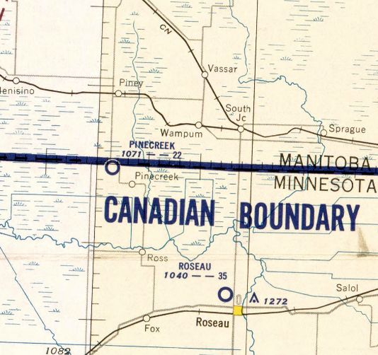
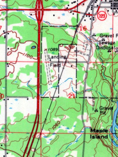
Piney Pinecreek Border Airport (48Y), Pinecreek, MN
48.999, -95.982 (Northwest of Duluth, MN)
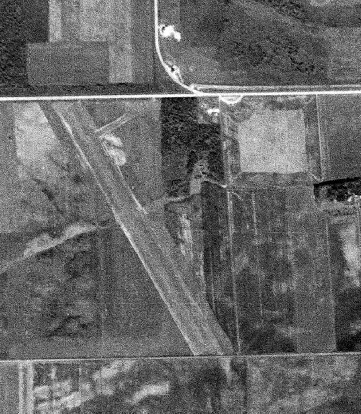
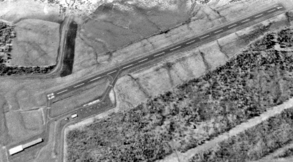
Piney Pinecreek Border Airport, as depicted on a 9/11/52 USGS aerial photo.
Piney Pinecreek Border Airport was one of 6 airports that crossed the Canada–US border & the easternmost.
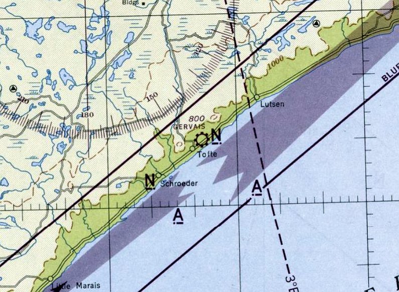
Piney Pinecreek Border Airport was not yet depicted on the November 1951 Lake of the Woods Sectional Chart.
The earliest depiction which has been located of Piney Pinecreek Border Airport was on a 9/11/52 USGS aerial photo.
It depicted a single unpaved northwest/southeast runway, which extended in the U.S. (but not yet over) the Canadian border.
There were no aircraft visible on the field.
According to its FAA Airport/Facility data, Piney Pinecreek Border Airport was activated in September 1952.
The earliest aeronautical chart depiction which has been located of Piney Pinecreek Border Airport was on the November 1952 Lake of the Woods Sectional Chart.
It depicted “Pinecreek” Airport as having a 2,200' unpaved runway.
A 10/14/65 USGS aerial view depicted Piney Pinecreek Border Airport as having a single unpaved northwest/southeast runway.
There were no aircraft visible on the field.
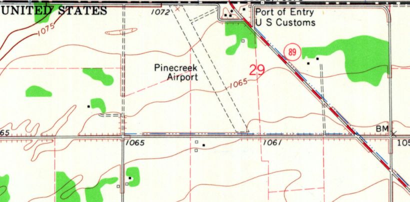
The earliest topo map depiction which has been located of Piney Pinecreek Border Airport was on the 1967 USGS topo map.
It depicted “Pinecreek Airport” as having a single northwest/southeast unpaved runway.
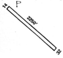
The 1975 Flight Handbook (courtesy of Jonathan Westerling) depicted Pine Creek Airport as having a single 2,250' Runway 14/32.
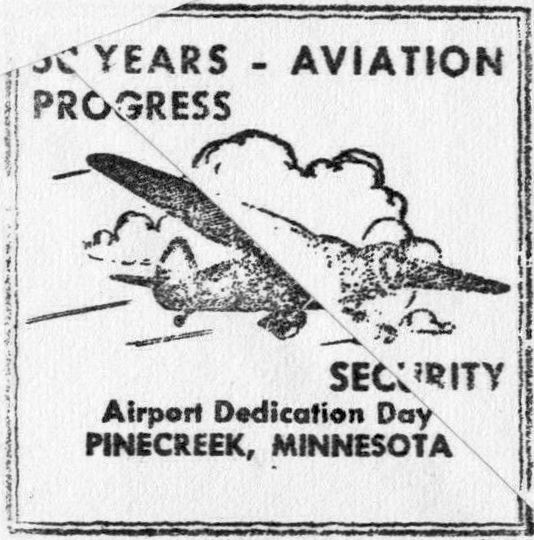
A 1979 postmark (courtesy of David Ross) commemorating “50 Years - Aviation Progress”, the Pinecreek Airport Dedication Day.
An article entitled “Boarder Airport Overcomes Gophers & Bureaucracies” buy Andrew Malcom in the 6/28/79 New York Times (courtesy of Jonathan Westerling) reported,
“Pinecreek is one of those tiny prairie towns that is so small both city limits signs could go up on the same post.
But Pinecreek & its Canadian neighbor, Piney, are about to go down in the history books - or rather, up on the world's aviation mans.
Finally, after years of binational talks, binational correspondence and binational bureaucratic nitpicking, this American community & its Canadian counterpart are about to open the world's first binational airport
unless some other pesky problem rears its head like a gopher on the runway.
On July 28 the Piney Pinecreek Binational Border Airport, which straddles the United States-Canadian border, will be formally dedicated.
Gov. Albert Quie of Minnesota & Premier Sterling Lyon of Manitoba are scheduled to be present.
There will be helicopters & jet flybys & parachutists & stunt fliers hanging upside down. And, of course, pancakes - courtesy of a Lutheran women's group.
Besides its unusual location & little-known aviation convenience as a customs clearing point for private planes,
the airport marks a 3,300' tribute in sod to the determination of two towns to overcome the bureaucratic barriers that stand along the invisible border here.”
“My stomach is so full of butterflies,” says Eugene Simmons, the American airport manager, “if only something else doesn't go wrong.”
Mr. Simmons, who is 81 years old, began the airport project when he was 51. Because of his advancing age, he lets his wife help fill in the gopher holes now.
But Mr. Simmons is still out there every two weeks or so, mowing the 49 acres of his beloved airfield where killdeer outnumber the planes.
Mr. Simmons, an aviation enthusiast, began to champion the airport idea in 1949 to facilitate the border's growing private plane crossings.
Thousands of fishermen, hunters and businessmen cross the border in private planes.
An airfield here to clear customs formalities would speed these travelers & reduce congestion at major fields in Minneapolis & Winnipeg.
It wouldn't hurt the area's reputation either, so the Pinecreek Improvement Association took on the project.
Pinecreek, a town without a post office, would have an airport.
The association's members obtained the approval of all of the town's neighbors, the customs agencies of both countries, and Minnesota's highway commissioner & Attorney General.
With Mr. Simmons in the forefront, the members lobbied .their legislators & met with bureaucrats, those faceless city folk regularly denounced by rural residents.
And they bargained down one local farmer whose land price suddenly seemed to exceed propriety.
On 7/29/53, the airport opened, little smaller than desired perhaps, but official nonetheless.
The runway ran smack up to the international boundary and ended, yet it quickly gained reputation as one of the best sod runways in these parts.
But problems began to spring up like dandelions. Canadian customs officials did not like having to traipse 100 yards into the United States to inspect every northbound plane.
And the planes were getting larger, but the runway wasn't. So in 1972 the airport's supporters proposed that the runway be lengthened.
One problem: To lengthen the field on the south meant closing a road & altering a mail route. The easiest plan, it seemed, was to lengthen the field 1,150' on the north.
Sure, it crossed the international border, but there was only brush there. And what's a border between friends? They found out.
Two local groups, one on either side of the border, jotted down an agreement. But it was unacceptable to Canada's Ministry of External Affairs, which required several more drafts.
The agreement seemed fine with State Department officials in Washington, but someone there suggested that they did not have the legislative authority to approve it.
So the late Senator Hubert Humphrey of Minnesota tacked a rider onto a foreign aid bill.
Then someone in Canada wondered whether a town like Piney could make an agreement with a foreign state. So that required a new law, too.
Canada also required the organization of formal airport authority with equal representation from both countries.
Then, of course, the land had to be purchased & the money appropriated to pay for it. Then the money had to be appropriated to build the airport.
And then the contract bids were let & there was some misunderstandings there. Finally, all was ready to begin construction.
That's when a bureaucrat down in St. Paul asked about state insurance & workmen's compensation. More talks, letters and phone calls followed, leading to a new insurance policy.
Work began & the grass was seeded. In the spring the airport commission - this year it's Canada's turn to chair it - set the date for the grand opening.
This year's frost brought up a lot of rocks, and they will have to be cleared away by the time the airport is dedicated.
The grass is growing out of control because Mr. Simmon's sickle bar is broken. And one State authority says he will require a new windsock; the old one is faded, he says.
Parking may be a problem, too. The airport wasn't built for 600 people. “Someday though,” said Ben Carnegie, the United States Customs Bureau officer, as he stepped out of the back door to clear the day's plane,
“I figure if we get enough publicity & more traffic & maybe some lights, too, we'll get a blacktop field here & grow from there.”
And someday after that, someone in Pinecreek may even own an airplane.
The 1983 AOPA Airports USA Directory (courtesy of Jonathan Westerling) described Piney Pinecreek Border Airport as having a single 3,300' turf Runway 13/31
and conducting gliding & parachuting activities.
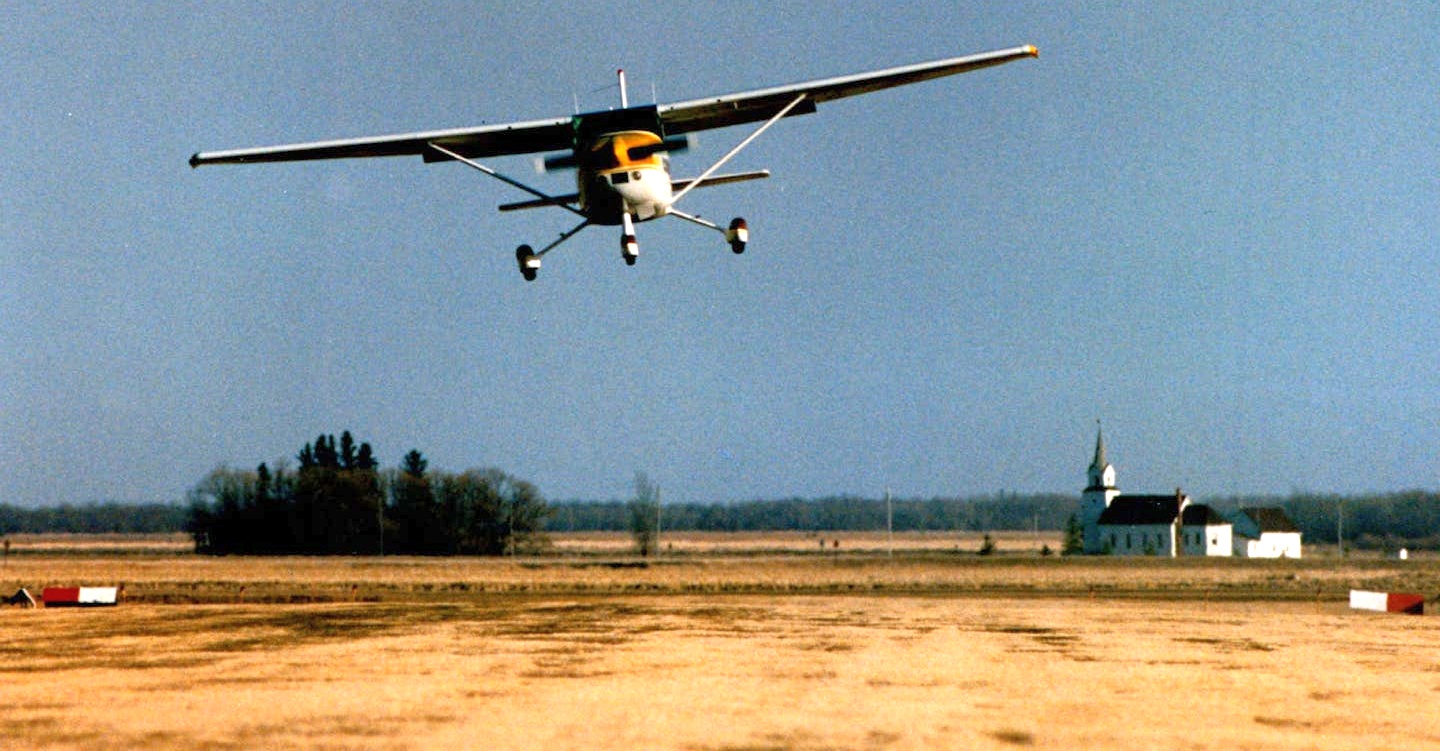
The only photo which has been located of an aircraft using Piney Pinecreek Border Airport was a 1993 photo of a single-engine Cessna landing on the grass runway.
The 1994 USGS topo map depicted “Pinecreek State Airport” as having a single northwest/southeast runway.
A 1994 aerial photo showed the Piney Pinecreek Border Airport runway remained unpaved,
and that is how it continued to be described in the 1995 AOPA Airports USA Directory (courtesy of Jonathan Westerling).
Piney Pinecreek Border Airport apparently gained a paved runway at some point between 1995-97,
as the 1997 AOPA Airports USA Directory (courtesy of Jonathan Westerling) described it as having a single 3,298' asphalt Runway 15/33,
and conducting airline service, agricultural operations, hang gliding, helicopter operations, parachuting, and ultralights.
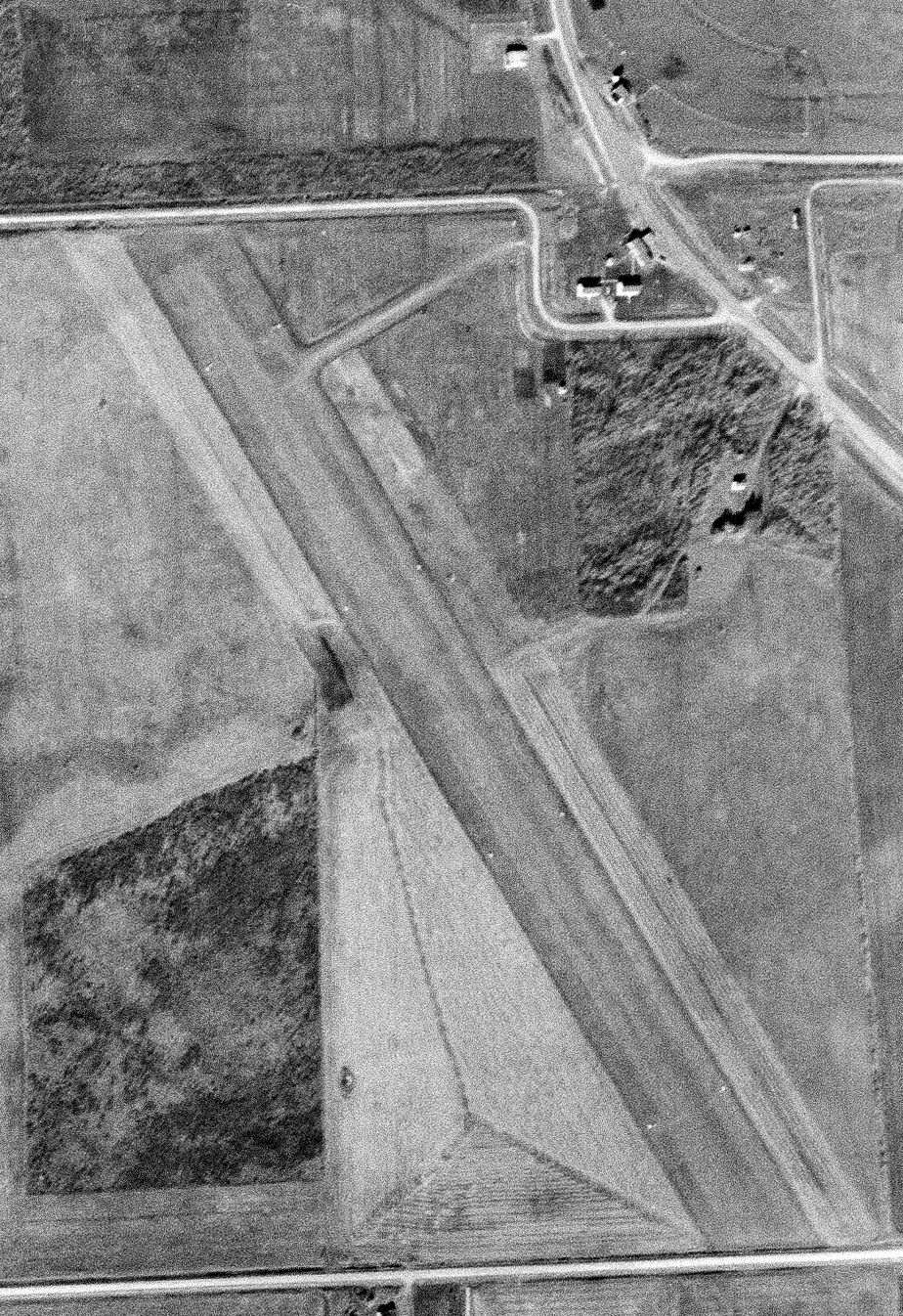
A 2003 aerial photo showed the Piney Pinecreek Border Airport runway had been upgraded to asphalt at some point between 1994-2003.
According to its FAA Airport/Facility data, for the year ending 5/31/11, Piney Pinecreek Border Airport conducted an average of 8 takeoffs or landings per day.
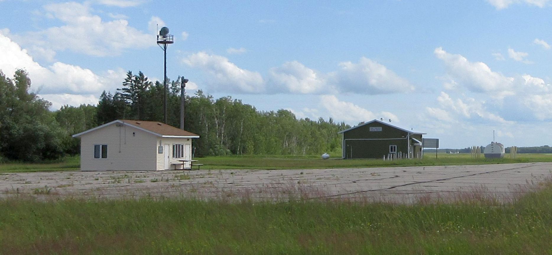
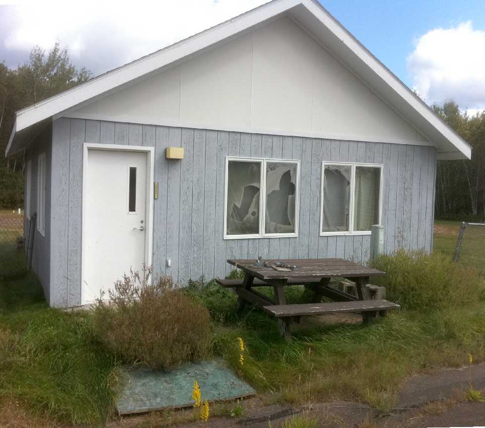
A 2019 photo of the Piney Pinecreek Border Airport ramp, with the building on the left in Canada & the building on the right being in the U.S.
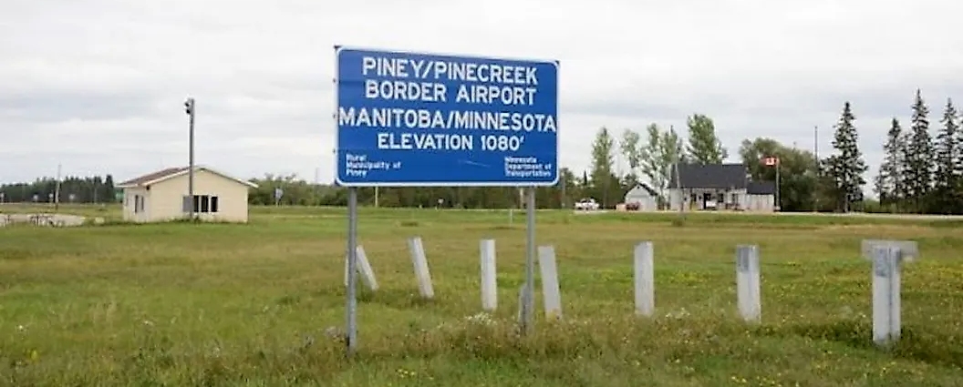
A pre-2024 photo of the Piney Pinecreek Border Airport sign, with the Canada & U.S. Customs facilities.
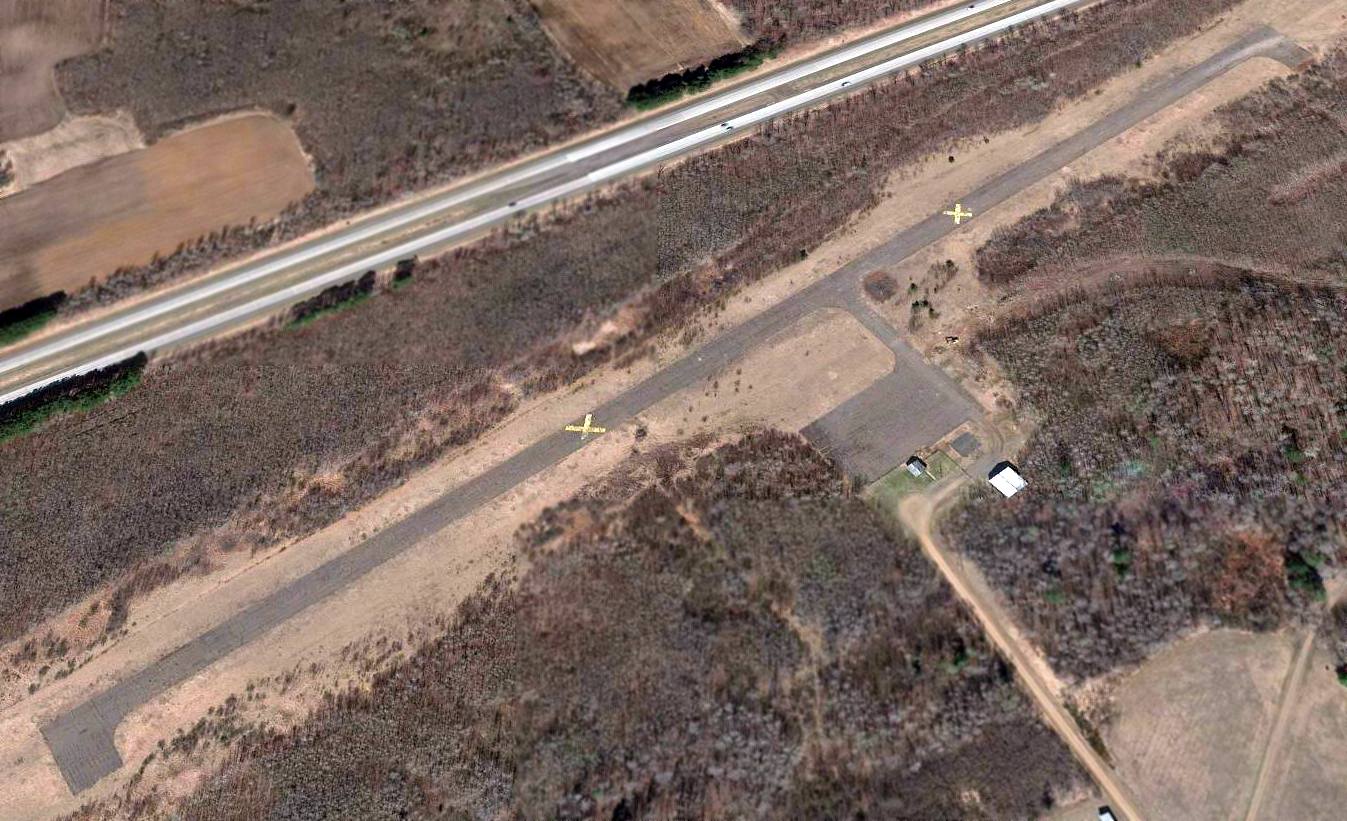
The 2024 Sectional Chart depicted Piney Pinecreek Border Airport as having a single 3,300' northwest/southeast paved runway.
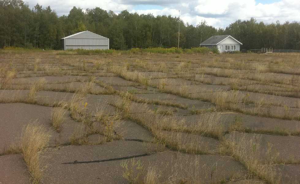
The 2024 Airfield/Facility Directory (courtesy of David Ross) depicted Piney Pinecreek Border Airport as having a single 3,297' asphalt Runway 15/33, “in poor condition”, with “tall vegetation growing through severe cracks”.
Piney Pinecreek Border Airport was described as being jointly owned by the MN Department of Transportation & the local government district of Piney Manitoba Canada, and was managed by Mark Elton.
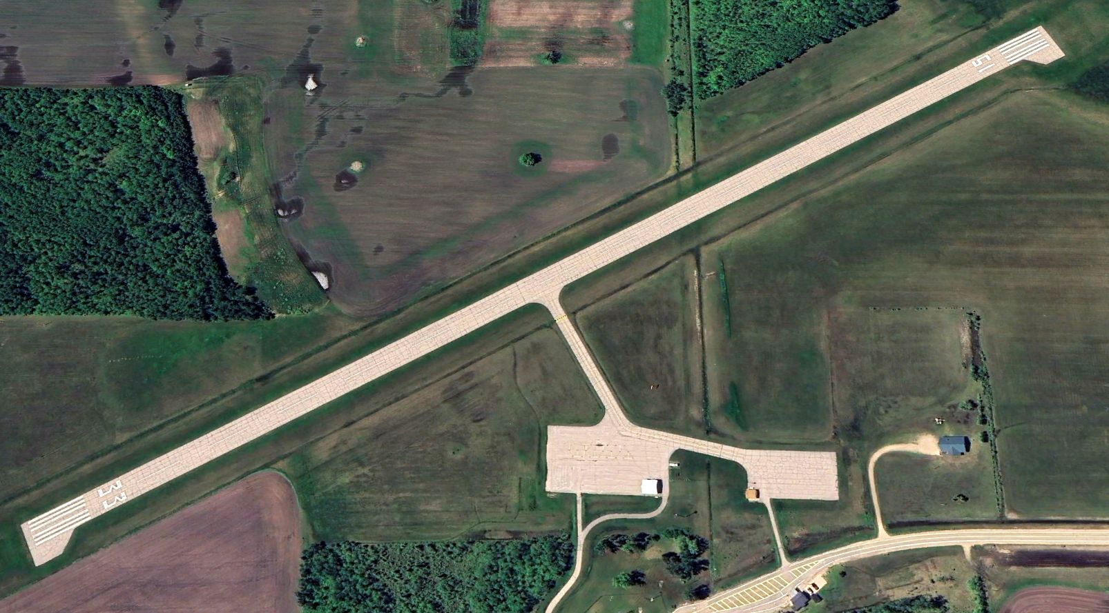
A 2024 aerial view looking west depicted Piney Pinecreek Border Airport as having a paved Runway 15/33, but there were no aircraft on the field.
According to Wikipedia, “Citing declining usage & significant impending repair costs, it was announced that the airport is scheduled for permanent closure on 12/27/24.
Costs for runway resurfacing & other repairs required to bring the airport up to current safety standards were estimated at $3.8 million.
As joint owner, the rural municipality of Piney, Manitoba was responsible for almost half of these costs, which they were unable to raise.
Without funding for repairs, officials from both governments elected not to renew the international agreement required to continue airport operations past this date.”
Thanks to Ron Plante for pointing out this airfield.
____________________________________________________
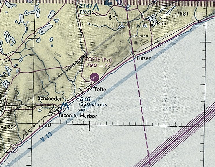
Gervais Landing Field / Cathedral of the Pines Airport / Tofte Airport (9MN9), Tofte, MN
47.588, -90.823 (Northeast of Duluth, MN)
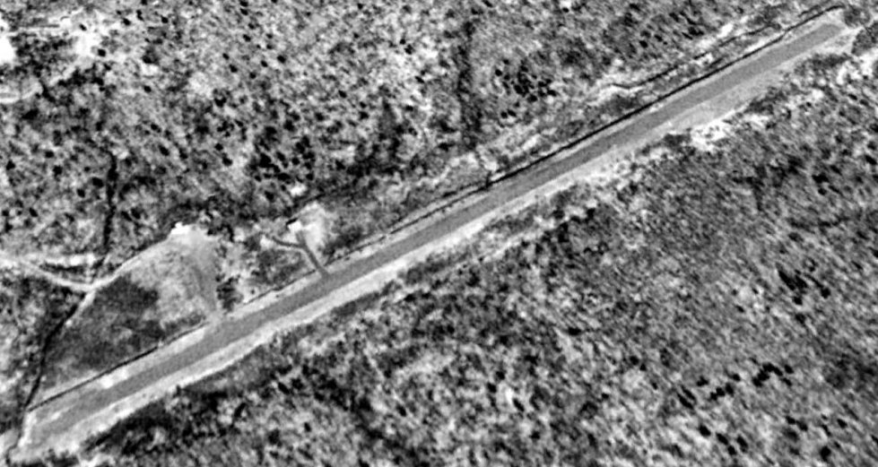
Gervais Landing Field, as depicted on the January 1946 Duluth Sectional Chart.
This small general aviation airport was evidently established at some point between 1945-46
(like hundreds of other small airports in the US post-WW2 aviation boom),
as it was not yet depicted on the June 1945 Duluth Sectional Chart.
The earliest depiction which has been located of Gervais Landing Field was on the January 1946 Duluth Sectional Chart.
It depicted Gervais as a commercial/municipal airport.
The earliest photo which has been located of Gervais Landing Field was a 1953 aerial view.
It depicted a single northeast/southwest unpaved runway, with a hangar on the northwest side.
There were no aircraft visible on the field.
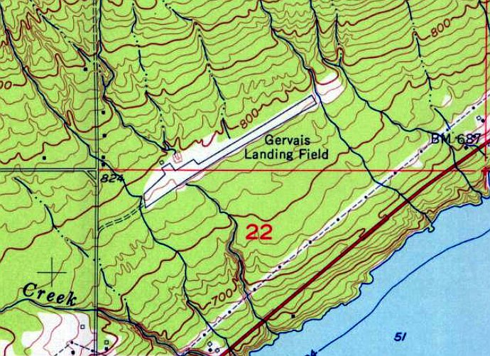
The earliest topo map depiction which has been located of Gervais Landing Field was on the 1955 USGS topo map.
It depicted Gervais Landing Field as having a single northeast/southwest paved runway, with a ramp & a small building on the northwest side.
At some point between 1955-77, Gervais Landing Field was evidently renamed Cathedral of the Pines Airport,
as that is how it was labeled on the 1977 USGS topo map, depicted with a single northeast/southwest runway.
Cathedral of the Pines Airport evidently was improved with a paved runway at some point between 1955-84,
as a 1984 aerial view depicted it as having a single northeast/southwest asphalt runway, and a 2nd hangar had been added on the northwest side.
There were no aircraft visible on the field.
A 1991 USGS aerial view looking north depicted Cathedral of the Pines Airport as having a single northeast/southwest paved runway, with 2 small hangars on the northwest side.
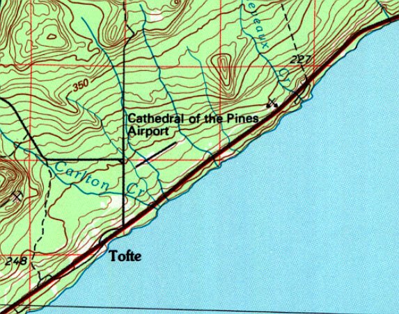
At some point between 1977-94, Cathedral of the Pines Airport was evidently renamed Tofte Airport,
as that is how it was labeled on the January 1994 Green Bay Sectional Chart (courtesy of Ron Plante), depicted as a private airfield with a single 2,700' northeast/southwest paved runway.
A report of a 3/14/96 accident (courtesy of Kyle Nobes) described how Cessna 172 N3898S nosed-over on landing at the Tofte Airport after hitting deep snow:
“The pilot reported that he received a weather briefing from the Kankakee Flight Service Station.
He received the NOTAMs for the route of flight & there was no mention of the airport being closed.
In discussions with the airport property owner, it was revealed that the airport had been closed since 1993 for repairs.
He stated the airport had been privately-owned but was given to the county as they were going to make the necessary repairs to the airport/runway.
The county did not do the repairs during the allotted time & the property was deeded back to the owner.
He stated it is currently a privately-owned airport which will most likely remain closed until 1998-99, when the repairs can be completed.
The January 1996 Green Bay Sectional shows the airport as open.
The current Airport Facilities Directory lists the airport as 'Unattended. Airport CLOSED indefinitely. Runway condition poor, 1-2 inch cracks & broken asphalt.'
The FAA Airport Safety Data Branch specialist stated that the airport will only be removed from the sectional if it is 'abandoned' or 'closed permanently' not 'closed indefinitely'.
However, the Airport Facility Directory will list the current status of the airport.”
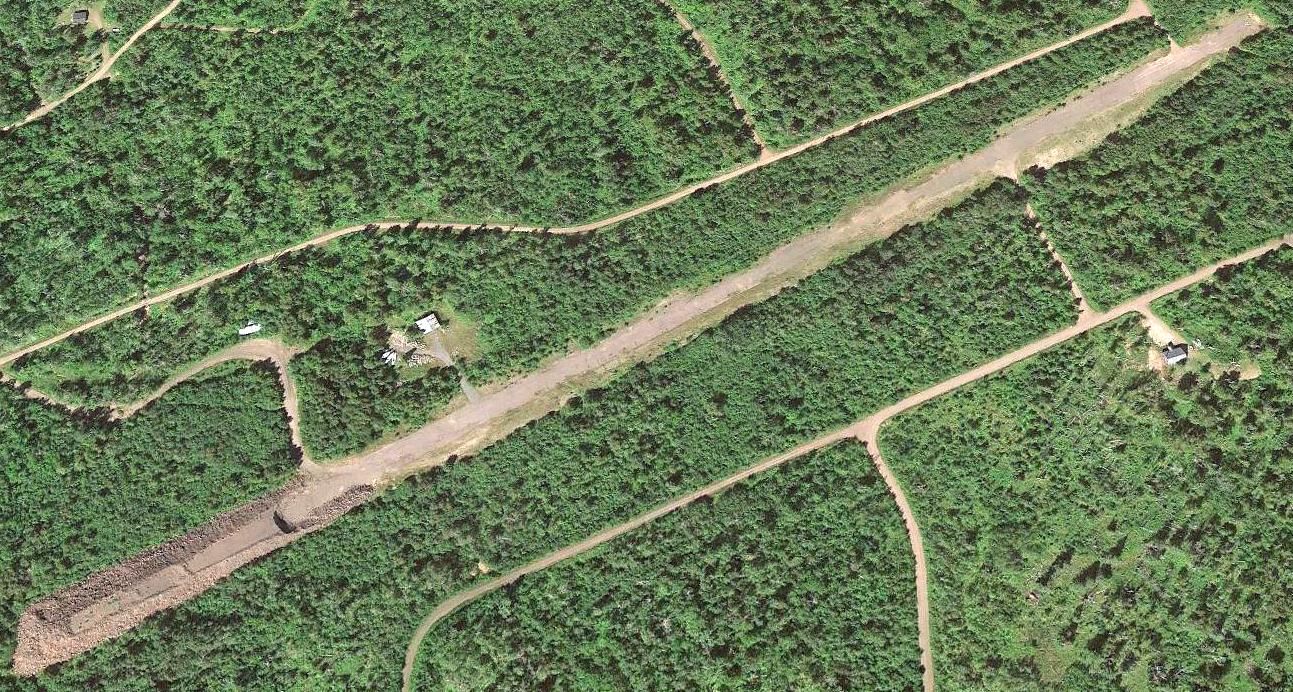
A 2013 aerial view looking north depicted Tofte Airport as having a single northeast/southwest paved runway, with 2 small hangars on the northwest side.
A large gravel pile covered the southwest runway end.
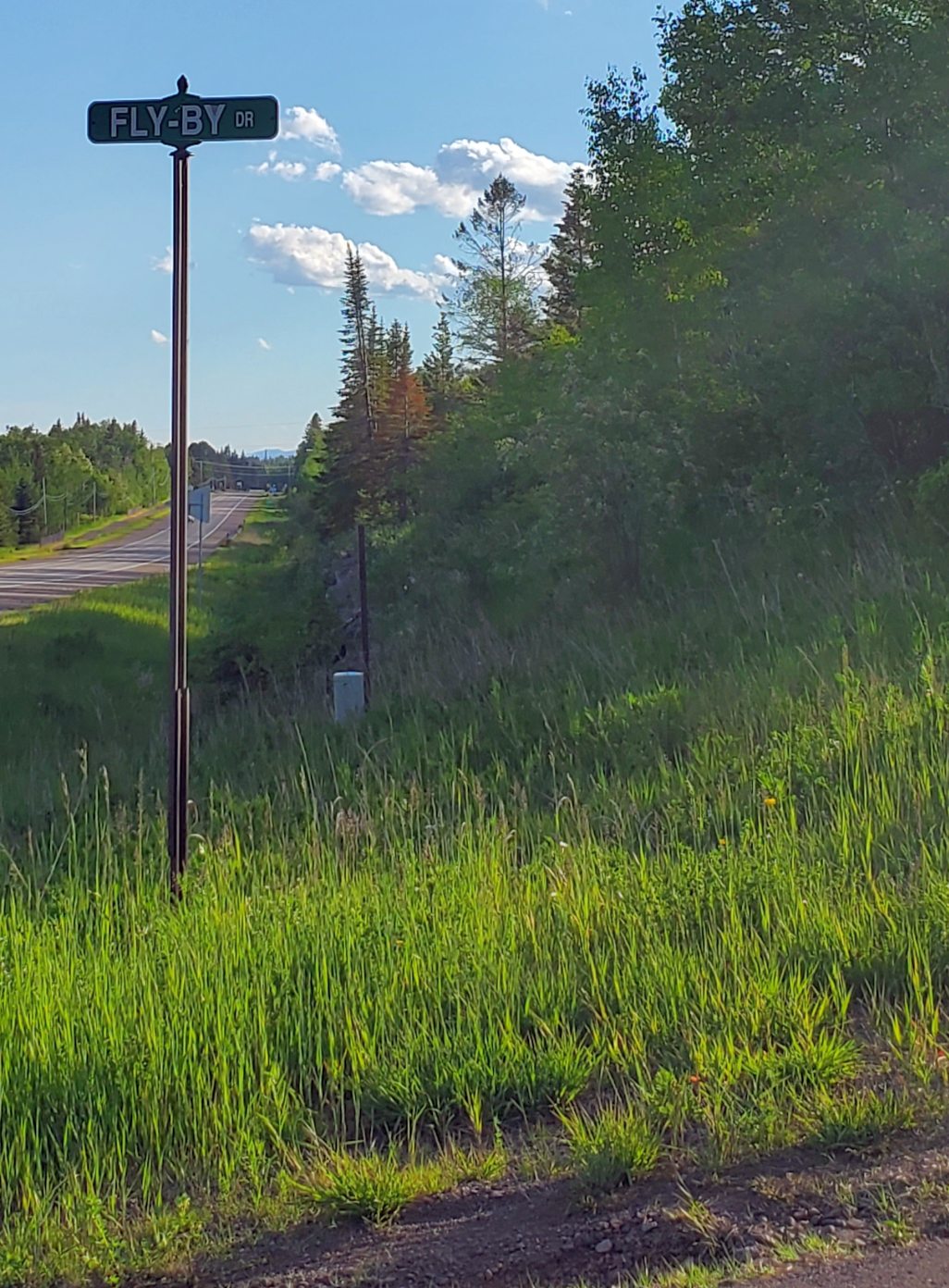
A 6/30/22 photo by Kyle Nobes of the street sign at the southern entrance to Tofte Airport, Fly-By Drive.
It leads to another street named Crosswind Trail. Was this intended to be a fly-in community?
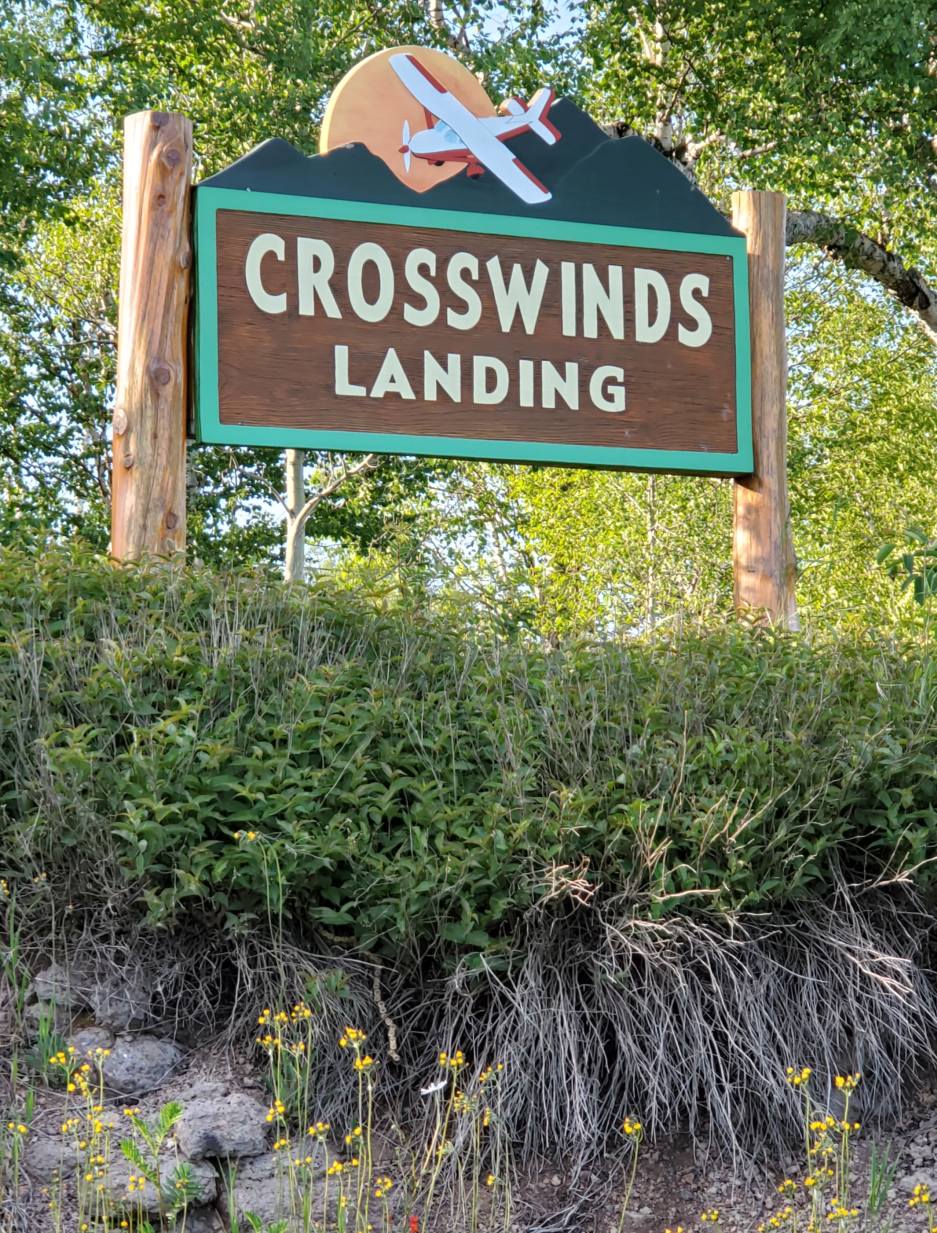
A 6/30/22 photo by Kyle Nobes of the “Crosswinds Landing” sign at Tofte Airport, presumably the name of the planned fly-in community.
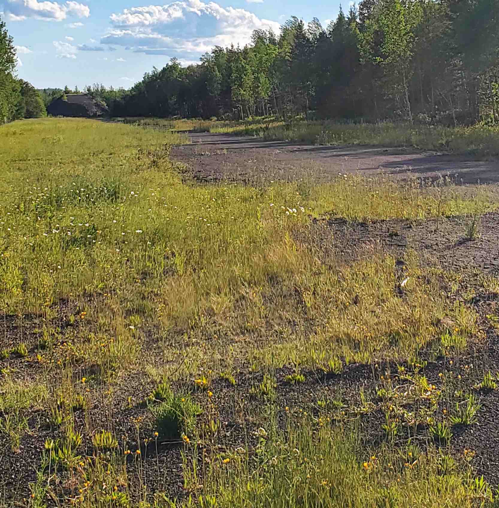
A 6/30/22 photo by Kyle Nobes looking southwest along the remains of the Tofte Airport paved runway, toward “A big pile of gravel owned by City of Tofte.
I drove out onto the runway from what appeared to be an old taxiway off Crosswind Trail.
Not much left to the runway, only some pavement on first third of northeast end.”

A 6/30/22 photo by Kyle Nobes of “a grader sitting on the northeast end” of the remains of the Tofte Airport runway.
Kyles Nobes reported, “On the GIS it appears a surgeon / development corporation from Minneapolis owns the runway & land around it.”
Thanks to Kyle Nobes for pointing out this airfield.
____________________________________________________
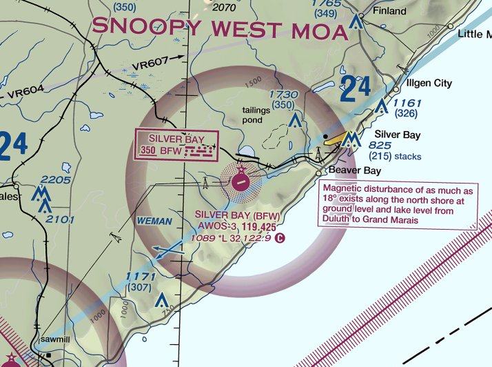
Silver Bay Airport / Wayne Johnson Silver Bay Municipal Airport, Silver Bay, MN
47.249, -91.416 (Northeast of Duluth, MN)
Silver Bay Airport, as depicted on the July 1965 Duluth Sectional Chart.
This small general aviation airport was evidently established at some point between 1964-65,
as it was not yet depicted on a 1954 aerial photo, the July 1964 Duluth Sectional Chart, or the 1964 USGS topo map.
The earliest depiction which has been located of Silver Bay Airport was on the July 1965 Duluth Sectional Chart.
It depicted Silver Bay Airport as having a 3,000' unpaved runway.
The 1965 USGS topo map depicted Silver Bay Municipal Airport as having a northeast/southwest paved runway, with a ramp & 2 small buildings on the northeast side.
The earliest photo which has been located of Silver Bay Airport was a 1981 aerial view.
It depicted Silver Bay Airport as having an asphalt Runway 7/25, with an asphalt ramp, 2 small buildings, and 2 light single-engine aircraft on the northeast side.
A 1991 USGS aerial view looking south at Silver Bay Airport showed the hangar had been relocated to a new ramp to the northeast at some point between 1981-91.
There were no aircraft visible on the field.
On 8/13/05, Silver Bay Airport was renamed Wayne Johnson Municipal Airport.
A 2010 aerial view of Silver Bay Airport showed 2 light aircraft on the ramp, and the runway markings were distinct.
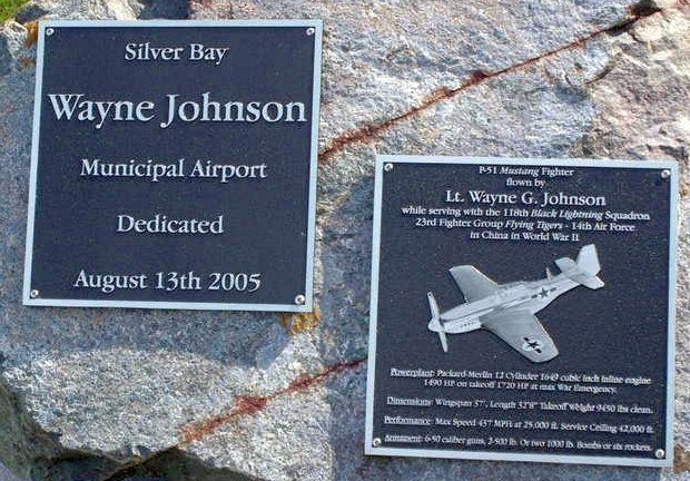
An 8/6/09 photo of the plaques commemorating the 2005 renaming of Wayne Johnson Municipal Airport.
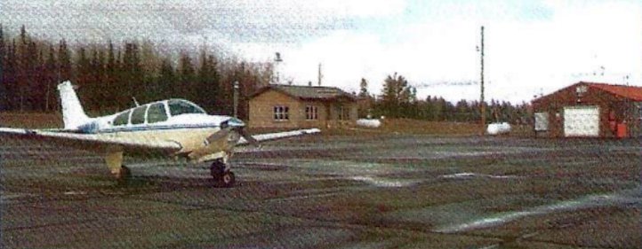
An undated photo of a Beech Bonanza at Silver Bay Airport (from the February 2012 MN Flyer, courtesy of Tom Foster).
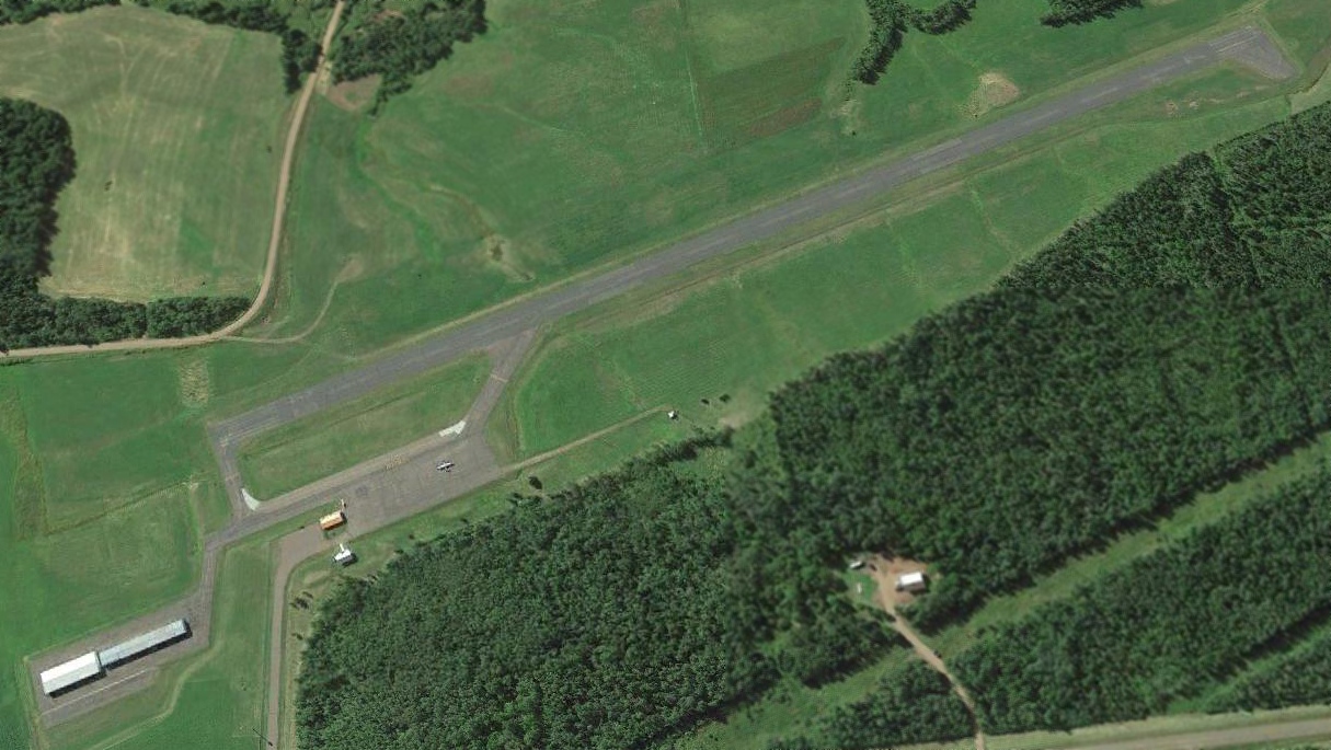
A 2013 aerial view looking south at Silver Bay Airport showed 1 light aircraft on the ramp, but the runway markings were considerably deteriorated, possibly having been removed.
A 2017 aerial photo showed 1 light single-engine aircraft parked on the Silver Bay Airport ramp.
The last aeronautical chart depiction which has been located showing Silver Bay Airport still open was on the May 2018 Duluth Sectional Chart.
It depicted Silver Bay Airport as having a single 3,200' northeast/southwest paved runway.
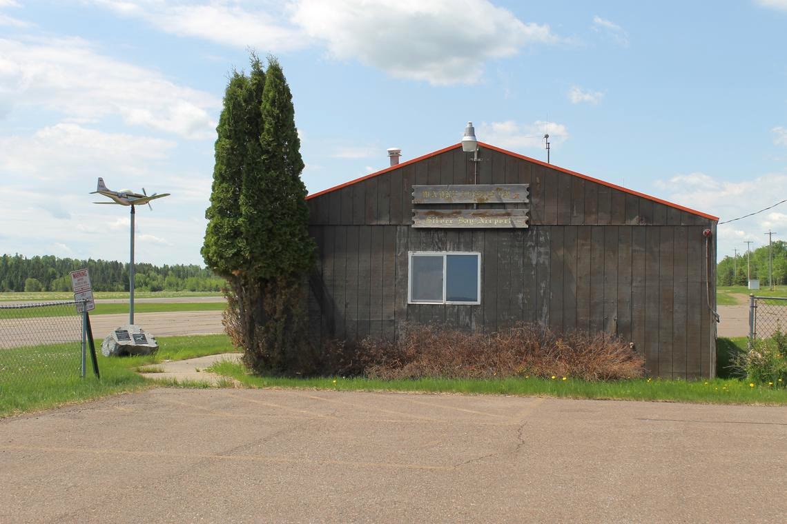
An undated photo of the Silver Bay Airport office, from a 2018 article, showing a P-51 Mustang model mounted on a pole as a wind direction indicator.
The P-51 is painted in the colors of Wayne Johnson's Mustang which he flew with the 118th TRS, 23rd Fighter Group, 14th Air Force in China during WW2.
A 6/10/18 Duluth News Tribune article reported, “The Wayne Johnson Silver Bay Municipal Airport has been closed by the Minnesota Department of Transportation Office of Aeronautics.
On May 31, two representatives from MnDOT who visited the airport to do a routine inspection found the runway condition had deteriorated enough to warrant closure.”
Silver Bay Airport was labeled “Closed” on the 2020 Duluth Sectional Chart.
Thanks to Lee Corbin for pointing out this airfield.
____________________________________________________
Ely Municipal Airport, Ely, MN
47.896, -91.836 (North of Duluth, MN)
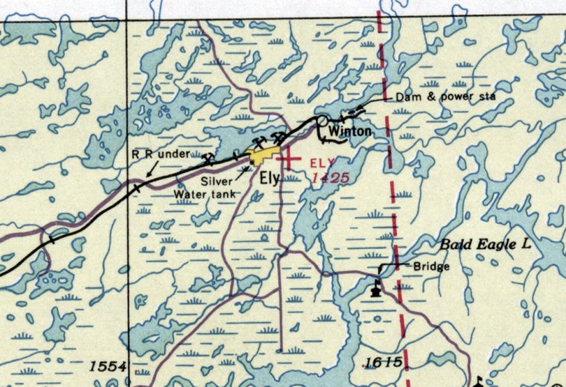
Ely Airport, as depicted on the September 1936 Duluth Sectional Chart.
According to a "Minnesota Flyer" magazine article (courtesy of Tom Foster), the original Ely Airport was established in 1933.
The earliest depiction which has been located of Ely Airport was on the September 1936 Duluth Sectional Chart.
It depicted Ely as an auxiliary airfield.
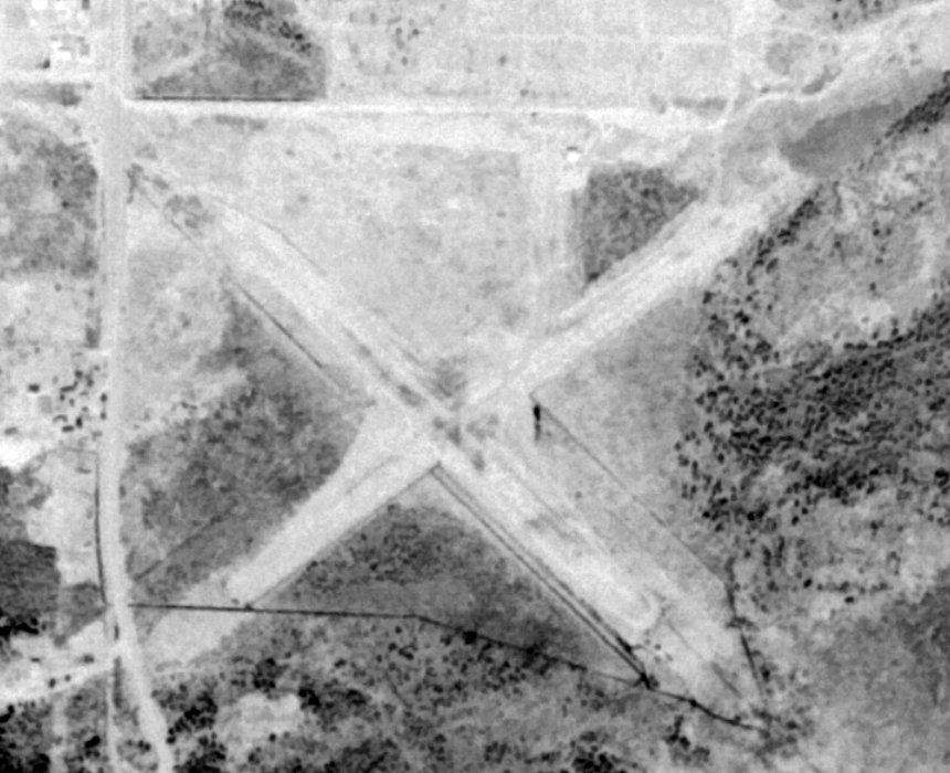
The earliest photo which has been located of Ely Airport was a 5/10/64 USGS aerial view (courtesy of Lee Corbin).
It depicted Ely as having 2 unpaved runways in an X-shape, with a small hangar on the northeast side.
There were no aircraft visible on the field.
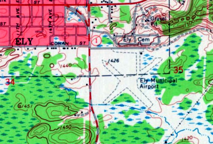
The 1965 USGS topo map depicted Ely Municipal Airport as having 2 unpaved runways in an X-shape, with a small building the northeast side.
The last aeronautical chart depiction which has been located of Ely Airport was on the July 1970 Duluth Sectional Chart.
It depicted Ely as having a 2,200' unpaved runway.
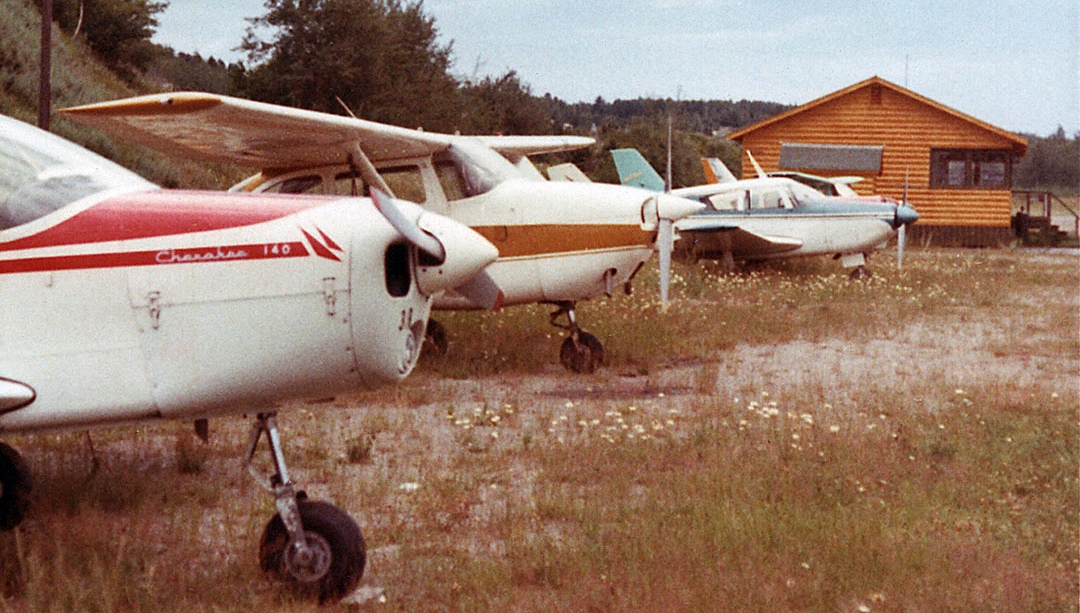
The only photo which has been located showing planes at the original Ely Airport was a 7/18/70 photo by Terry Schwartz.
Terry recalled, “I flew in the red/white Cherokee 140 on the left.
The 'Terminal Building' on the right was unattended, and contained not much more than a phone book & a pay phone.”
According to a "Minnesota Flyer" magazine article (courtesy of Tom Foster), the original Ely Airport was closed in 1972 when it was replaced by their new airport.
A 1991 USGS aerial photo (courtesy of Lee Corbin) showed baseball diamonds had been built over the northern part of the site of the original Ely Airport.
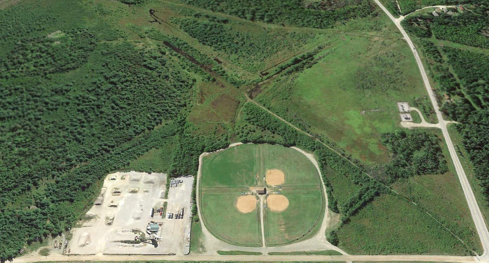
A 2013 aerial view looking south showed the characteristic orientation of Ely Airport's 2 former runways was still recognizable.
The former hangar also remained standing (the green-roofed building to the left of the baseball diamonds).
Thanks to Lee Corbin for pointing out this airfield.
____________________________________________________
Coleraine Airport, Coleraine, MN
47.281, -93.429 (Northwest of Duluth, MN)
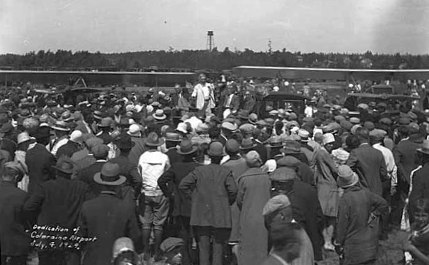
A 7/4/29 photo of the dedication of Coleraine Airport (from the Minnesota Historical Society, courtesy of Terrence Schwartz).
Coleraine Airport was dedicated on 7/4/29, as depicted in a photo of a crowd standing in front of 2 biplanes (from the Minnesota Historical Society, courtesy of Terrence Schwartz).
The earliest aeronautical chart depiction which has been located of Coleraine Airport was on the September 1936 Duluth Sectional Chart.
The only aerial photo which has been located of Coleraine Airport was a 5/2/47 USGS aerial photo.
It depicted the field as an unpaved northwest/southeast runway,
with 6 light single-engine aircraft & a small hangar on the northwest corner.
Eric Thomsen recalled, the “old airport used to be located right next to Trout Lake.”
The last aeronautical chart depiction which has been located of Coleraine Airport was on the May 1950 Duluth Sectional Chart.
It depicted Coleraine Airport as having a 2,200' unpaved runway & a seaplane base.
Coleraine Airport may have been closed (for reasons unknown) at some point between 1950-51,
as a 1951 aerial photo showed no aircraft on the field, which otherwise remained intact.
The 1952 USGS topo map did not depict Coleraine Airport, instead simply depicted an unlabeled clearing.
Coleraine Airport was no longer depicted on the May 1956 Duluth Sectional Chart (courtesy of Ron Plante).
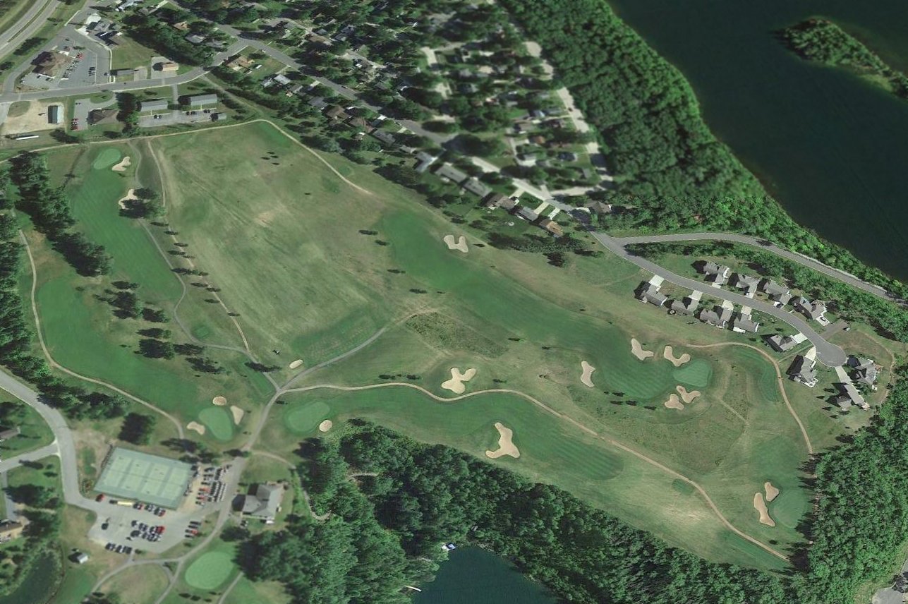
A 2013 aerial view looking northeast shows no trace remaining of Coleraine Airport, with the property covered by a golf course & houses.
As of 2017, street maps depict the site of Coleraine Airport as Eagle Ridge Golf Course.
The site of Coleraine Airport is located southeast of the intersection of Route 169 & McLean Avenue.
Thanks to Eric Thomsen for pointing out this airfield.
____________________________________________________
47.63, -91.415 (North of Duluth, MN)
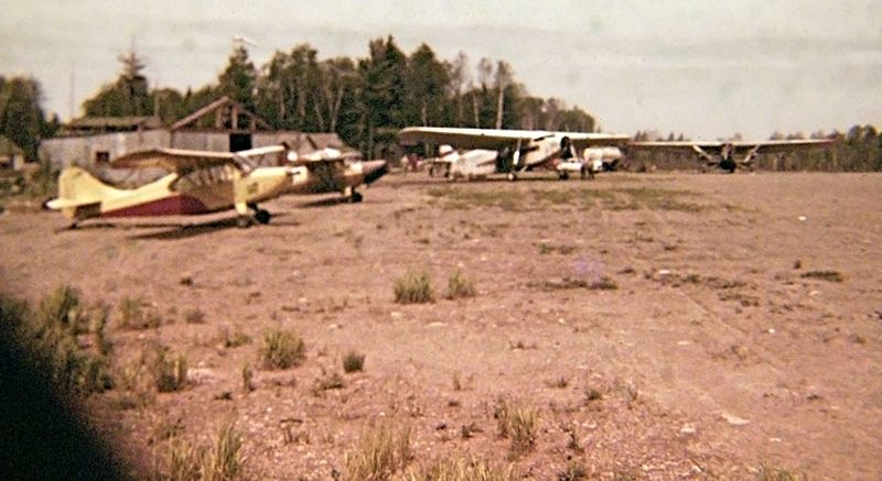
A 1960-63 photo by Roger Duncan (enhanced by Bill Grasha) of 4 planes at Duncan Airport, “when Johnson Brothers of Missoula used the strip for spray operations for the U.S. Forest Service.”
Duncan Airport was not depicted on a 1953 aerial photo, Duluth Sectional Charts from 1956, 1960, or 1970, or USGS topo maps from 1957, 1963, or 1976.
Roger Duncan recalled, “In the late 1950s, my dad, Jasper Duncan, built an airport near Isabella & was home to Duncan Airways, Inc.”
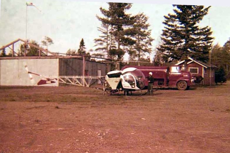
A 1960-63 photo by Roger Duncan (enhanced by Bill Grasha) of a Bell 47 helicopter at Duncan Airport.
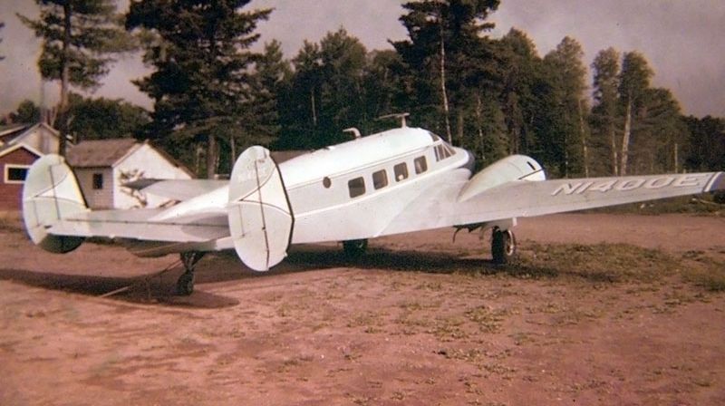
A 1960-63 photo by Roger Duncan (enhanced by Bill Grasha) of a Beech 18 at Duncan Airport.
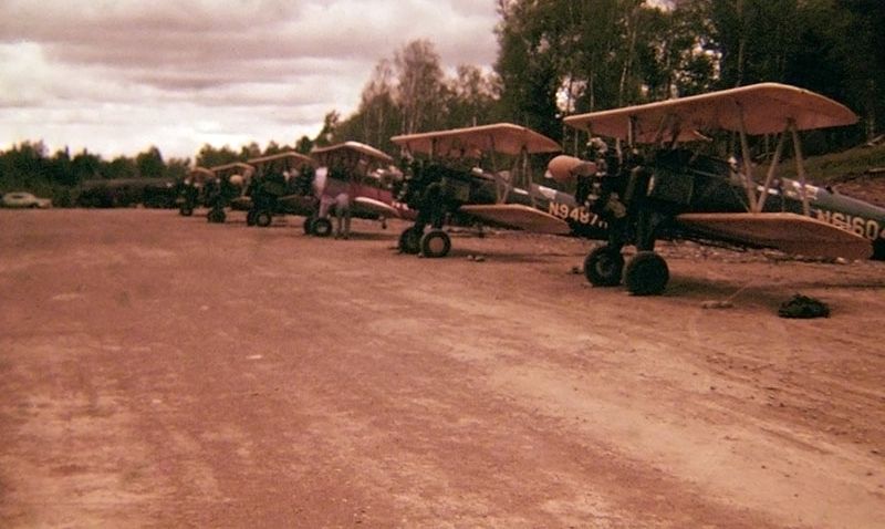
A 1960-63 photo by Roger Duncan (enhanced by Bill Grasha) of a row of 6 Stearman biplanes at Duncan Airport.
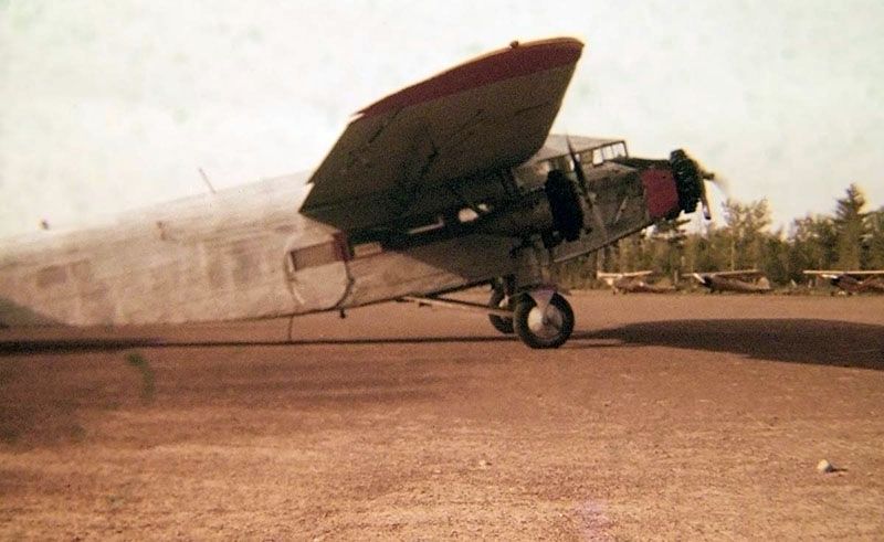
A 1960-63 photo by Roger Duncan (enhanced by Bill Grasha) of the remarkable spectacle of a Ford Trimotor at Duncan Airport.
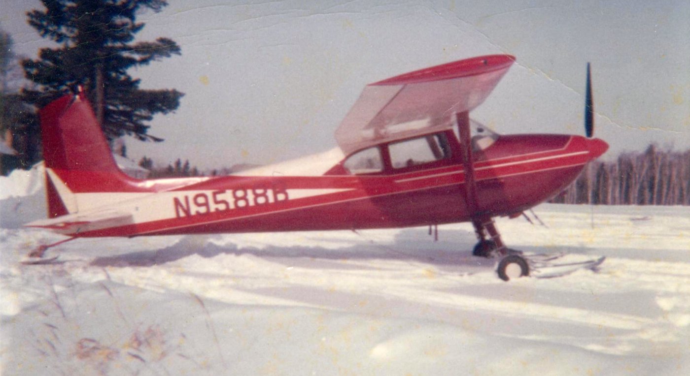
A 1960-63 photo by Roger Duncan of a Cessna 180 at Duncan Airport.
Roger Duncan recalled, “N9588B was kept on the airport during the winter months & on floats during the summer for moose hunting & fishing charters into Canada.”
The only airport directory depiction which has been located of Duncan Field was in the 1961 MN Airport Directory.
It depicted Duncan Field as having a single 2,500' sod northwest/southeast runway.
Roger Duncan recalled, “The airport was licensed by the State of Minnesota but was closed & abandoned a few years after he [Jasper Duncan] sold it.”
A 10/19/77 USGS aerial view depicted Duncan Airport as having an unpaved northwest/southeast runway.
A few small buildings were depicted on the northwest corner of the field, but there were no aircraft visible.
The 1982 USGS topo map depicted a northwest/southeast runway clearing, but the airfield was not labeled.
Roger Duncan recalled, “The current owner of the property built a garage on the runway to stop people from using it due to liability issues.”
A 1992 aerial view showed the garage built along the northern portion of the runway.
A 2013 aerial view looking southeast shows the majority of the Duncan Airport runway remains intact, though with a garage built along the northern portion.
The site of Duncan Airport is located on the east side of Route 1, three miles west of Isabella.
Thanks to Roger Duncan for pointing out this airfield.
____________________________________________________
Skyport Airport / Devil's Track Municipal Airport (GRM), Grand Marais, MN
47.825, -90.38 (Northeast of St. Paul, MN)
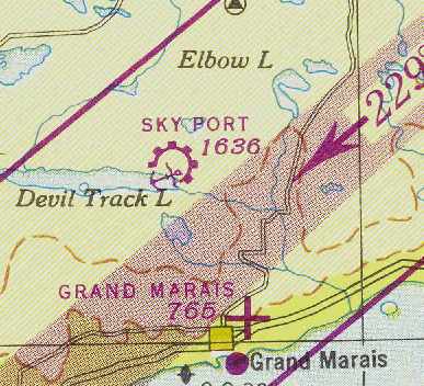
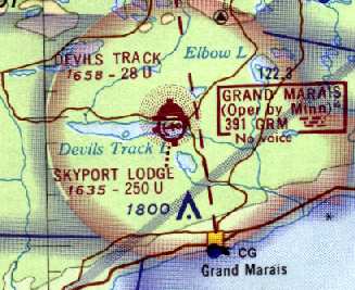
Skyport Airport & Seaplane Base, as depicted on the November 1948 Duluth Sectional Chart (courtesy of Chris Kennedy).
This small general aviation airport was located on the shore of Devil's Track Lake a few miles south of the Canadian Border.
It originally consisted of both a runway for land plane operations & a seaplane base.
Skyport Airport was not yet depicted on the December 1944 Duluth Sectional Chart (according to Chris Kennedy)
or the March 1945 Green Bay World Aeronautical Chart (according to Chris Kennedy).
According to a "Minnesota Flyer" magazine article (courtesy of Tom Foster), “After World War 2 Clarence Krotz opened Sky Port Lodge at Devils Track Lake.
Mr. Krotz also built the airport & seaplane base, which were licensed in 1947.
Besides the operating the lodge, he did charters & flight instruction in a Piper J-3.”
The earliest depiction which has been located of Skyport Airport was on the November 1948 Duluth Sectional Chart (courtesy of Chris Kennedy).
It depicted “Skyport” as a municipal/commercial airport & a seaplane base.
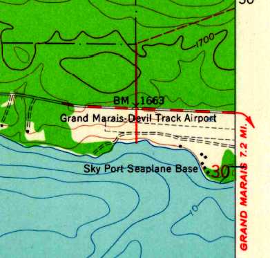
The 1960 USGS topo map depicted “Grand Marais - Devil Track Airport”
as having a single unpaved east/west runway, with the “Sky Port Seaplane Base” to the south.
The 1962 AOPA Airport Directory described "Grand Marais Municipal" as having a single turf 2,600' Runway 9/27,
listed the operator as Skyport Lodge.
According to a "Minnesota Flyer" magazine article (courtesy of Tom Foster), “It became a state airport, then was deeded to the county in the late 1960s.
Eventually the airport was paved & lighted.”
By the time of the July 1969 Duluth Sectional Chart (courtesy of John Voss),
Devil's Track had a single 2,800' paved runway & its own NDB navigational beacon.
Dave Lee recalled of Skyport Lodge, “I used to work there in the early 1970s.
At that time it was owned by Clarence Krotz, and run by his family.
I used to spend summers up there, and do odd jobs around the place for them.”
According to Randy Sohn, Devil's Track Airport was operated by Duane & Judy Cole.
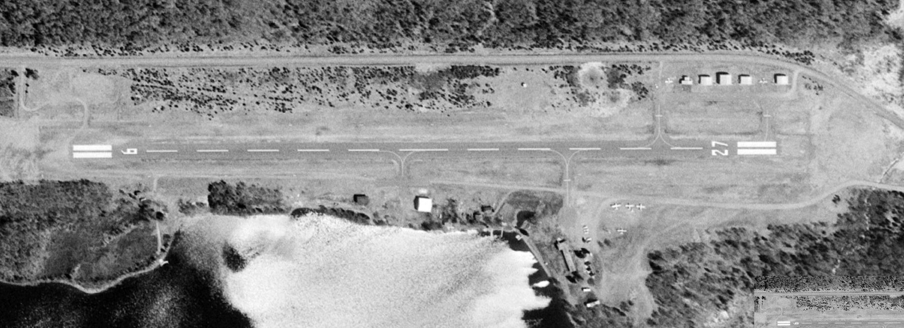
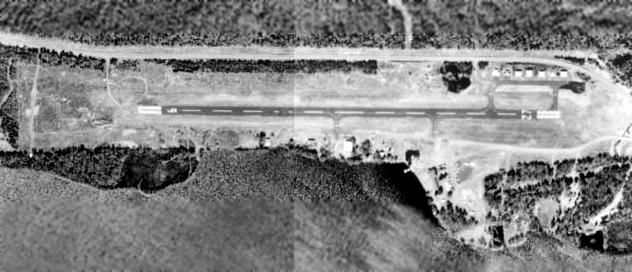
The earliest photo which has been located of Devil's Track Airport was a 6/6/76 USGS aerial view.
It showed Devil's Track Airport to have a single paved east/west Runway 9/27, with a few small hangars on the northeast side, and 6 light single-engine aircraft parked outside.
According to a "Minnesota Flyer" magazine article (courtesy of Tom Foster), “Clarence Krotz managed the airport & operated the lodge until 1980.”
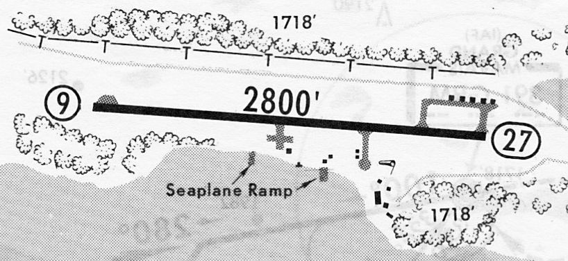
A 7/3/81 airport directory (courtesy of John Kielhofer) depicted Devil's Track Municipal Airport as having a paved 2,800' Runway 9/27,
with taxiways leaving to several small hangars on the south & northeast sides.
Two seaplane ramps were also depicted to the south.
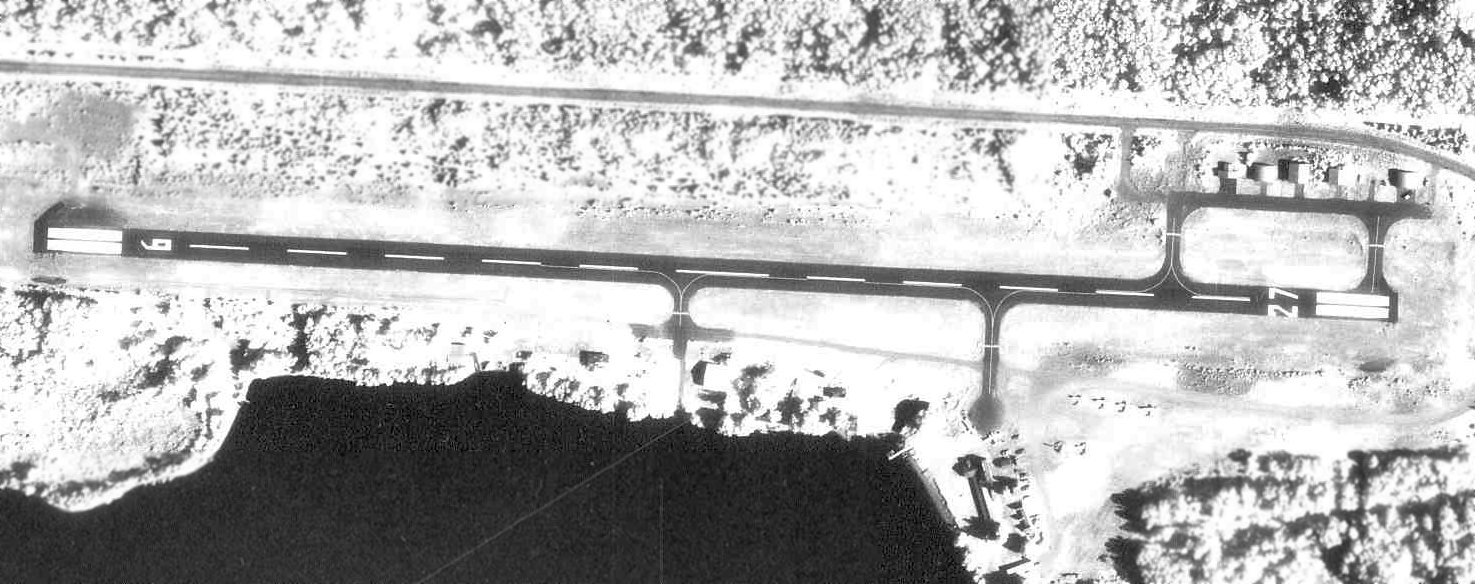
An 8/11/82 aerial view (from the Minnesota Historical Aerial Photographs Online) depicted Devil's Track Airport
as having a paved east/west Runway 9/27, with a few small hangars on the northeast side & 4 light aircraft parked on the southeast side.
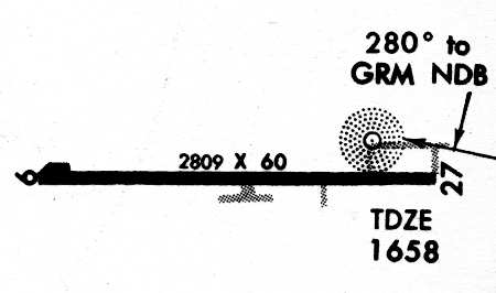
Devil's Track Municipal Airport, as depicted on the July 1990 Approach Procedures (courtesy of Timothy Aanerud).
As of the 1991 USGS aerial photo, Devil's Track Airport consisted of a single paved 2,800' Runway 9/27, a small ramp & several single-aircraft hangars.
The last listing which has been located of the Devil's Track Municipal Airport as an active airfields was in the 1989 North Central Airport Facility Directory.
The Devil's Track Municipal Airport was evidently closed at some point between 1989-93,
as the 1993 Airport/Facility Directory showed that it had been replaced by the new Grand Marais Cook County Airport, a mile to the north.
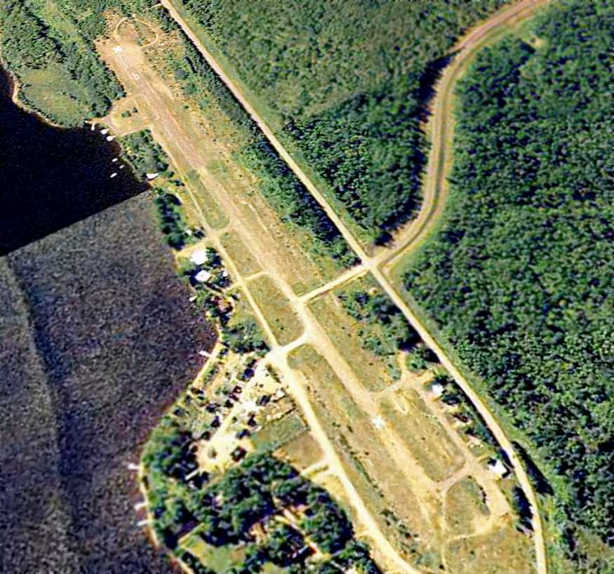
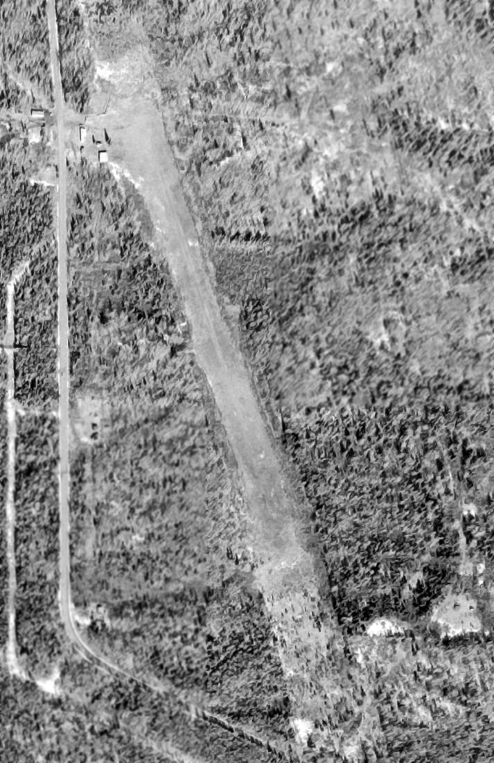
A June 2003 USGS aerial view looking northwest along the Devil's Track runway shows the facility appears to remain completely intact.
A 2013 aerial view looking northwest showed the Devil's Track Airport runway remained intact, but all of the hangars except one had been removed at some point between 2003-2013.
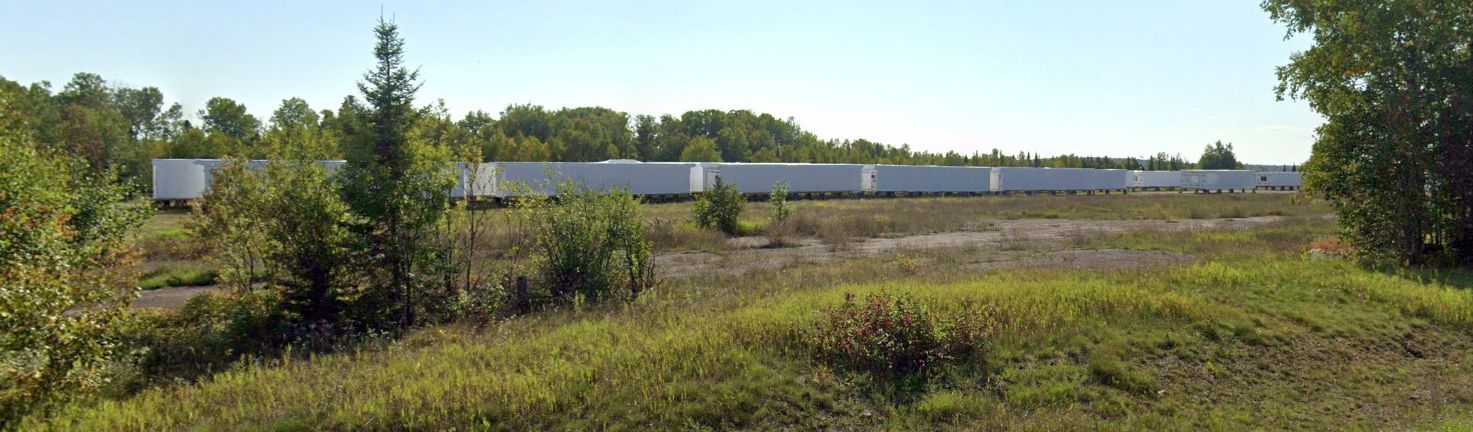
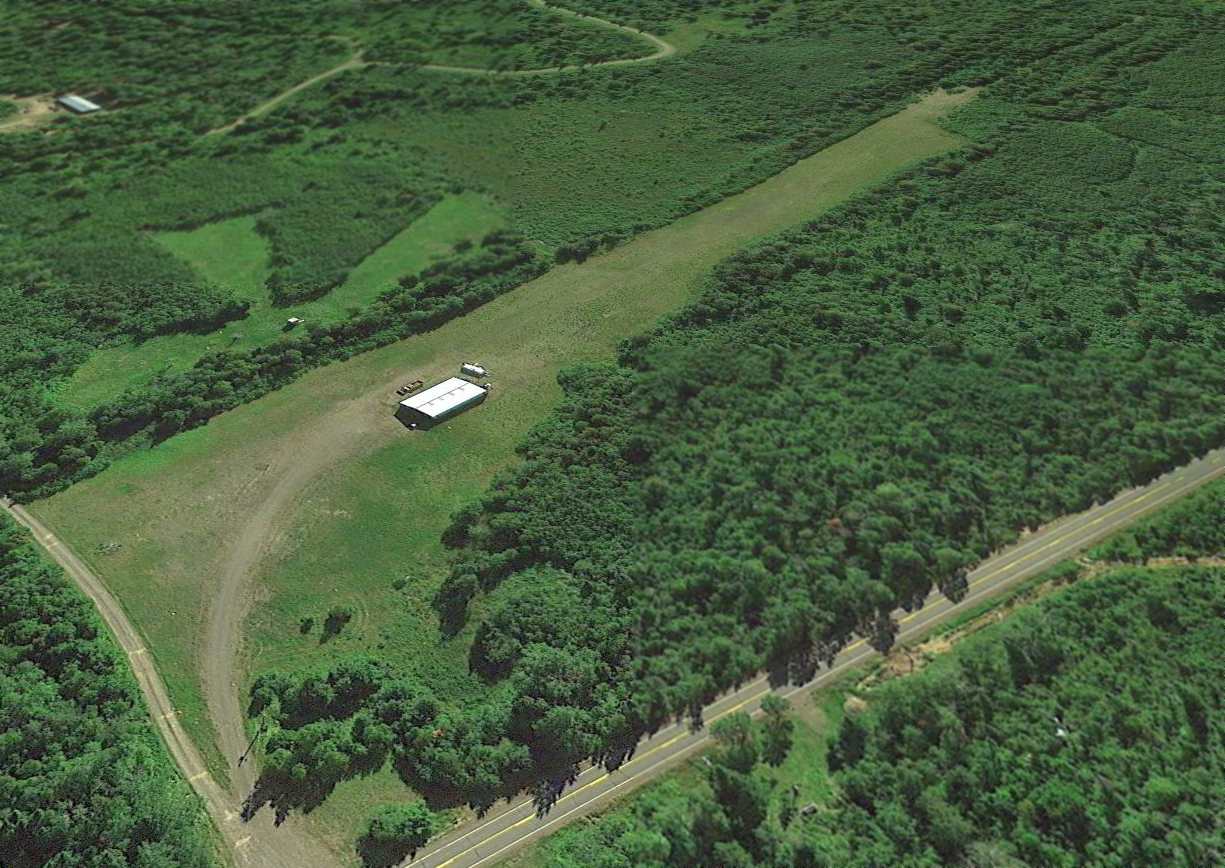
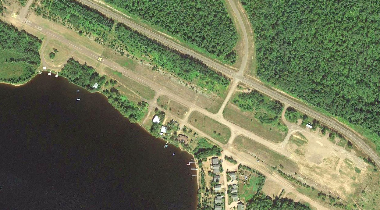
A 2025 photo looking southwest at the Devil's Track Airport site, showing the ramp & hangar foundations, and trailers being stored on the former runway.
Only the seaplane facilities at Devil's Track Lake continue to remain active, with a new name & identifier: Grand Marais Cook County Seaplane Base (0G5).
Thanks to Timothy Aanerud for pointing out this airfield.
____________________________________________________
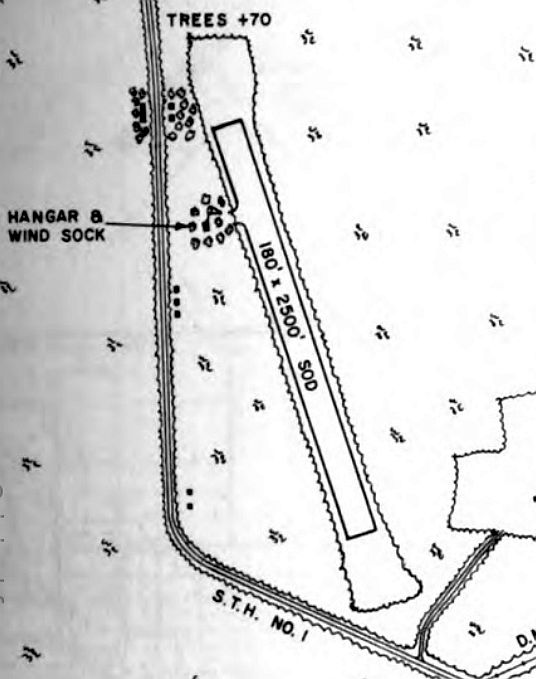
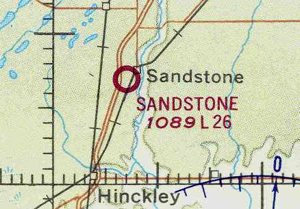
Sandstone Municipal Airport (57Y), Sandstone, MN
46.115, -92.89 (North of Minneapolis, MN)
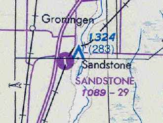
Sandstone Municipal Airport, as depicted on the 1961 USGS topo map.
This small general aviation airport was located adjacent to US I-35.
Sandstone Municipal Airport was not yet depicted on the April 1954 Duluth Sectional Chart (according to Chris Kennedy) or a 1957 aerial photo.
According to Tail Dragger, “The Sandstone Municipal Airport was originally laid out in the late 1950s with a natural surface runway.”
The earliest depiction of Sandstone Municipal Airport which has been located was on the 1961 USGS topo map.
It depicted an unpaved northwest/southeast runway, labeled simply as “Landing Strip”, with a small building on the east side.
The earliest directory listing which has been located of Sandstone Municipal Airport
was in the 1962 AOPA Airport Directory, which described it as having a 2,600' long sod runway.
The operator was listed as Rex Kerr.
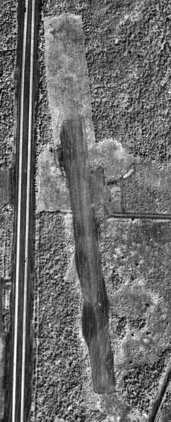
The earliest photo which has been located of Sandstone Municipal Airport was an 8/12/82 aerial view (from the Minnesota Historical Aerial Photographs Online).
It depicted Sandstone as having an unpaved northwest/southeast runway, with no buildings or aircraft visible.
The earliest aeronautical chart depiction of Sandstone Municipal Airport which has been located
was on the November 1971 CF-18 World Aeronautical Chart (courtesy of Chris Kennedy).
It depicted the field as having a 2,600' unpaved runway.
According to Tail Dragger, Sandstone Municipal Airport “was first paved in the 1970s.”
The July 1979 Green Bay Sectional Chart (courtesy of Chris Kennedy) depicted Sandstone as having a single 2,900' paved runway.
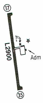
The 1987 Flight Guide (courtesy of Chris Kennedy) depicted Sandstone as having a single 2,900' paved Runway 17/35,
with a taxiway leading to a ramp on the east side of the field with a few small buildings, including the Administration building.
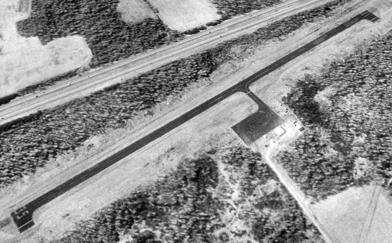
A 1991 USGS aerial view looking northwest depicted Sandstone Municipal Airport as having a single 2,900' paved Runway 17/35, and a small paved ramp area.
There were not any hangars on the field, and no aircraft were visible in the field either.
The 1998 Airport/Facility Directory described Sandstone Municipal Airport
as having a single 2,900' asphalt Runway 17/35.
However, the field was described as being unattended,
and the remarks said, "Runway 17/35 surface cracking & breaking up, cracks 2" wide with grass."
According to Tail Dragger, “It was built over a wetland area.
Over time, large pockets of clay soil beneath the 2,900' runway would shift with the freezes & thaws of the seasons,
causing the pavement to bend & buckle.
In 1999 & again in 2000, the MN Department of Transportation's Office of Aeronautics failed the runway for being too rough.
Repair costs were beyond the reach of the city's budget & state support for repair was limited.
There was no room to expand the runway to accommodate larger aircraft,
with an interstate highway to the northwest & an active railroad to the southeast.
With only 2 or 3 aircraft using the facility on a regular basis, the city council voted to close the airport in 2001.”
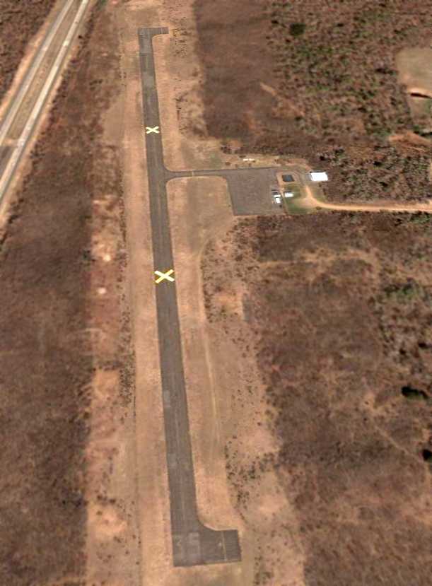
A 4/24/05 aerial view looking north along the Sandstone runway shows this fine little general aviation facility appears to remain completely intact –
what a shame to see it going to waste.
Tail Dragger reported, “Trailers used by the DNR are visible, but they are no longer there”, as of 2013.
An August 2012 photo by Tail Dragger of Sandstone's overgrown ramp, hangar, and office.

An August 2012 photo by Tail Dragger of airport markings which remain at Sandstone.
An August 2012 photo by Tail Dragger of the former Sandstone Municipal Airport office building.
Tail Dragger reported in 2013, “The ramp area has been used in recent years by the MN Department of Natural Resources
to temporarily land helicopters during wildland firefighting operations & fuel must be trucked in.
The DNR helicopter crews will occasionally sleep in the old office building when on required rest periods
and sometimes bring in trailers for extra bunk space.
The city uses the lone hangar on the property for storage.
A wireless phone tower has recently been erected near the southeast end of the runway.
Currently owned by the Sandstone Economic Development Authority,
there are plans to develop the airport property for a senior apartment community & assisted living facility,
which would be within a short drive of a planned hospital.”
A 2015 aerial view looking northwest depicted Sandstone Municipal Airport as remaining intact.
A 2025 aerial photo shows a road, Lursdorff Drive, was built over the majority of the former Sandstone runway at some point between 2015-2025.
The site of Sandstone Municipal Airport is located at the end of Airport Road, appropriately enough.
See also: http://www.dot.state.mn.us/aero/avoffice/ops/airdir/drawings/sandston.html
____________________________________________________
Or if you prefer to contact me directly concerning a contribution (for a mailing address to send a check),
please contact me at: paulandterryfreeman@gmail.com
If you enjoy this web site, please support it with a financial contribution.
____________________________________________________
This site covers airfields in all 50 states.