Abandoned & Little-Known Airfields:
West Virginia: Northeastern
© 2002, © 2026 by Paul Freeman. Revised 7/1/26.
This site covers airfields in all 50 states: Click here for the site's main menu.
____________________________________________________
Please consider a financial contribution to support the continued growth & operation of this site.
Burlington Airport / Baker Air Park (revised 7/14/22) - Capon Springs Airfield (added 8/6/24) - Cedar Meadows Airpark (added 3/29/20) - Charles Town Airport (added 3/18/21) - Dawson AAF (1st location) (revised 4/17/20)
Keyser Airport (revised 11/14/23) - Lewis Field / Brushy Fork Airport (revised 7/1/26) - Miller Field (revised 6/4/21) - Moorefield Airport (revised 1/15/21) - Rexroad Airfield (1st location) (revised 09/24/17)
Rexroad Airfield (2nd location) (revised 4/23/22) - Stump's Airfield (revised 5/4/20) - Summit Point Airport (added 3/29/20) - Thomas Airfield (revised 12/3/25) - Woodworth Field (added 4/23/20)
____________________________________________________
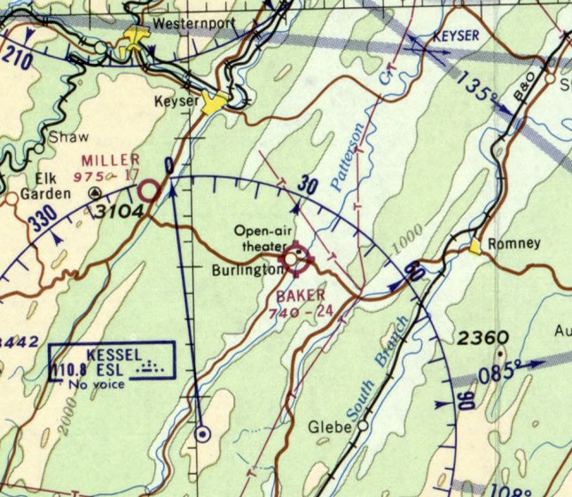
Capon Springs Airfield, High View, WV
39.147, -78.483 (West of Washington, DC)
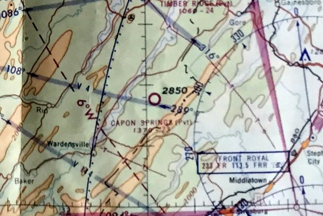
Capon Springs Airfield, as depicted on the July 1962 Huntington Sectional Chart.
Photo of the airfield while in use has not been located.
This small private airfield was evidently constructed at some point between 1958-63,
as it was not yet depicted on a 1958 aerial photo.
The earliest depiction which has been located of Capon Springs Airfield was on the July 1962 Huntington Sectional Chart.
It depicted Capon Springs as a private airfield having a 2,300' unpaved runway.
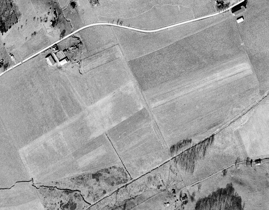
The earliest photo which has been located of Capon Springs Airfield was on a 1963 aerial photo,
which showed a newly-cleared unpaved northeast/southwest runway.
There were no aircraft or any buildings visible on the airfield.
Aerial photos from 1966 & later years continued to show the airfield in the same configuration, and never with any aircraft visible.

The earliest topo map depiction which has been located of Capon Springs Airfield was on the 1967 USGS topo map.
It depicted a single unpaved northeast/southwest runway, generically labeled “Landing Strip”.
David Warner recalled, “The field at Capon Springs... I believe it closed in the 1970s due to a nervous lawyer that advised the family to close it down.”

The last aeronautical chart depiction which has been located of Capon Springs Airfield was on the 1981 Washington Sectional Chart.
It depicted Capon Springs as a private airfield having a 2,300' unpaved runway.

The last topo map depiction which has been located of Capon Springs Airfield was on the 1987 USGS topo map.
It depicted a single northeast/southwest runway, generically labeled “Landing Strip”.
Capon Springs Airfield was evidently closed at some point between 1981-89,
as it was no longer depicted on the 1989 Washington Sectional Chart.
David Warner recalled, “Capon [Springs Airfield] was closed when I started working with the hotel/resort in the 1990s.
They kept it mowed & I’ve walked and measured the entire area & explored options for dealing with obstructions & terrain clearance.
I tried getting it reopened when I lived there. I was making good progress with the new generation of owners when I moved away in 2018.”

A 2019 aerial view showed the Capon Springs Airfield runway remained cleared, even though there's no indication it has been used as an airfield in almost 4 decades.
The site of Capon Springs Airfield is located on the south side of Airport Road, appropriately enough.
Thanks to David Warner for pointing out this airfield.
____________________________________________________
Lewis Field / Brushy Fork Airport, Buckhannon, WV
38.991, -80.27 (West of Washington, DC)

A circa 1943 aerial view looking north at Lewis Field from the 1945 AAF Airfield Directory (courtesy of Scott Murdock).
Lewis Field was not yet depicted on the 1942 Huntington Sectional Chart.
According to the Upshur County Airport website, “The prior airstrip along Brushy Fork Road [Lewis Field] was dedicated on 5/23/43
as part of the WV Wesleyan College program of pilot pre-flight training for World War II.”
The earliest depiction which has been located of Lewis Field was a circa 1943 aerial view from the 1945 AAF Airfield Directory (courtesy of Scott Murdock).
It depicted Lewis as having a rectangular unpaved landing area with several buildings along the north side.
The 1945 AAF Airfield Directory (courtesy of Scott Murdock) described Lewis Field as a 76 acre property having 2 sod runways, measuring 2,100' east-northeast/west-southwest & 1,850' northeast/southwest.
The field was said to have 2 hangars, and to be owned & operated by private interests.
The earliest aeronautical chart depiction which has been located of Lewis Field was on the May 1944 Huntington Sectional Chart,
which depicted Lewis as a commercial/municipal airport.
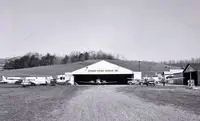
The earliest ground-level photo which has been located of Lewis Field was a circa 1950 photo of several light planes next to the Upshur Flying Service hangar.
The last photo which has been located showing Lewis Field still in operation was a 2/24/57 USGS aerial view.
It depicted 2 hangars on the north side of an northeast/southwest grass runway. No aircraft were visible on the field.
A 1963 aerial view showed Lewis Field in an unchanged configuration.

The earliest topo map depiction which has been located of Lewis Field was on the 1966 USGS topo map.
It depicted “Brushy Fork Airport” as having a single unpaved northeast/southwest runway, with 3 small buildings on the north side.
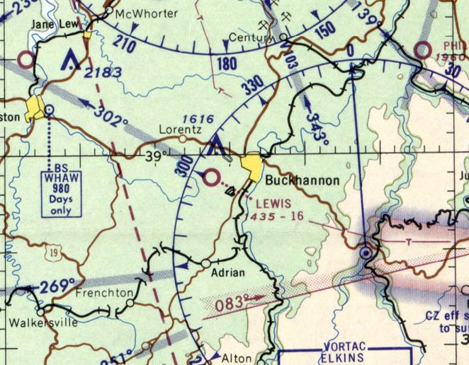
The last aeronautical chart depiction which has been located of Lewis Field was on the February 1969 Huntington Sectional Chart.
It depicted Lewis as having a mere 1,600' unpaved runway.
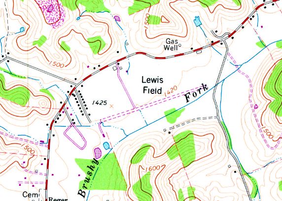
The last topo map depiction which has been located of Lewis Field was on the 1979 USGS topo map.
It depicted “Lewis Field” as having a single unpaved northeast/southwest runway, with 3 small buildings on the north side.
A 1982 aerial view showed Lewis Field in a very revised configuration.
It had gained a paved northeast/southwest runway at some point between 1963-82, along with 2 checkerboard-roof hangars on the southwest side.
Five light single-engine planes were parked near the hangars on the north side, which had also gained 2 other buildings.
The last photo which has been located showing aircraft at Lewis Field was a 1986 aerial view, which showed 2 light single-engine planes on the north side.
A 1996 aerial view did not show any aircraft at Lewis Field, and it also appeared as if the asphalt runway pavement had been removed at some point between 1986-96.
According to the Upshur County Airport website, “The prior landing strip at the base of the hill [Lewis Field] was closed in May 1998” when the new Upshur County Airport was opened.
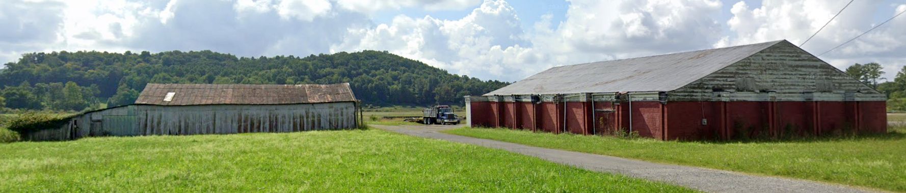
A 2023 photo looking southwest at the 2 hangars which remain on the north side of the Lewis Field site.

A 2023 photo looking southeast at the western hangar with attached office which remains on the north side of the Lewis Field site.

A 2024 photo of the Lewis Field site showed the hangars remained on the north & southwest sides, and the alignment of the runway is still recognizable, even though the runway pavement had been removed for a few decades.
The site of Lewis Field is located southeast of the intersection of Brushy Fork Road & Iesson Drive, less than a half-mile south of the present-day Upshur County Airport.
____________________________________________________
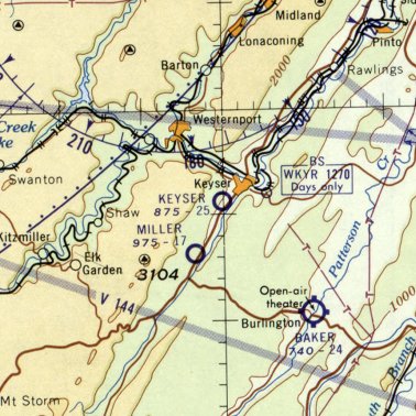
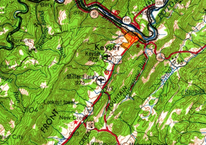
Miller Field (WV18), Keyser, WV
39.408, -79.014 (Northwest of Washington, DC)
Miller Field, as depicted on the October 1948 Huntington Sectional Chart.
According to Wings Over Cumberland (courtesy of Rick Harshbarger), “During WW2, Forrest Miller served as an instructor in the Civilian Pilot Training Program & in the War Training Service.
After the war, he continued instructing from his own airstrip, Miller Field, established in 1946, near Keyser.”
According to Rick Harshbarger, “Forest Miller was a local farmer who developed a love of aviation, eventually becoming a CFI & owning at least 1 tailwheel aircraft.”
A 1946 aerial view did not yet show any sign of Miller Field.
According to its FAA Airport/Facility Directory data, Miller Field was established in September 1947.
Miller Field was not yet depicted on the October 1947 Huntington Sectional Chart.
The earliest photo which has been located of Miller Field was a 1947 aerial view.
It showed the beginnings of a unpaved northwest/southeast runway.
The earliest aeronautical chart depiction which has been located of Miller Field was on the October 1948 Huntington Sectional Chart,
which depicted Miller as having a mere 1,700' unpaved runway.
Saundra Pancake reported, “Bill Pancake's Bill soloed at Miller Field on his 16th birthday, 2/9/56.
His instructor was the owner of the field Forrest Miller.”
The January 1960 Huntington Sectional Chart depicted Miller Field as having a 1,700' unpaved runway.
Miller Field, as depicted on the 1962 USGS topo map.
A 1966 aerial view showed Miller Field to have an unpaved northwest/southeast runway, but there did not appear to be any hangars.
Miller Field was not depicted at all on the 1981 USGS topo map.
A 1982 aerial view showed a row of small hangars had been added along the west side of Miller Field at some point between 1966-82.
But there were not any aircraft visible on the field.
Rick Harshbarger reported, “This little field was known area-wide because it was the home of Bill Pancake who was the best instrument repairman & tailwheel airplane expert in WV.
People flew in from all over. I've lived an 1/8 of a mile north of this field since 1987.
I could hear airplanes doing their run-ups on the ground & engines revving during their takeoff roll.
I could see the faces of the pilots as the field was configured to turn north, (left) right over my house after takeoff.”
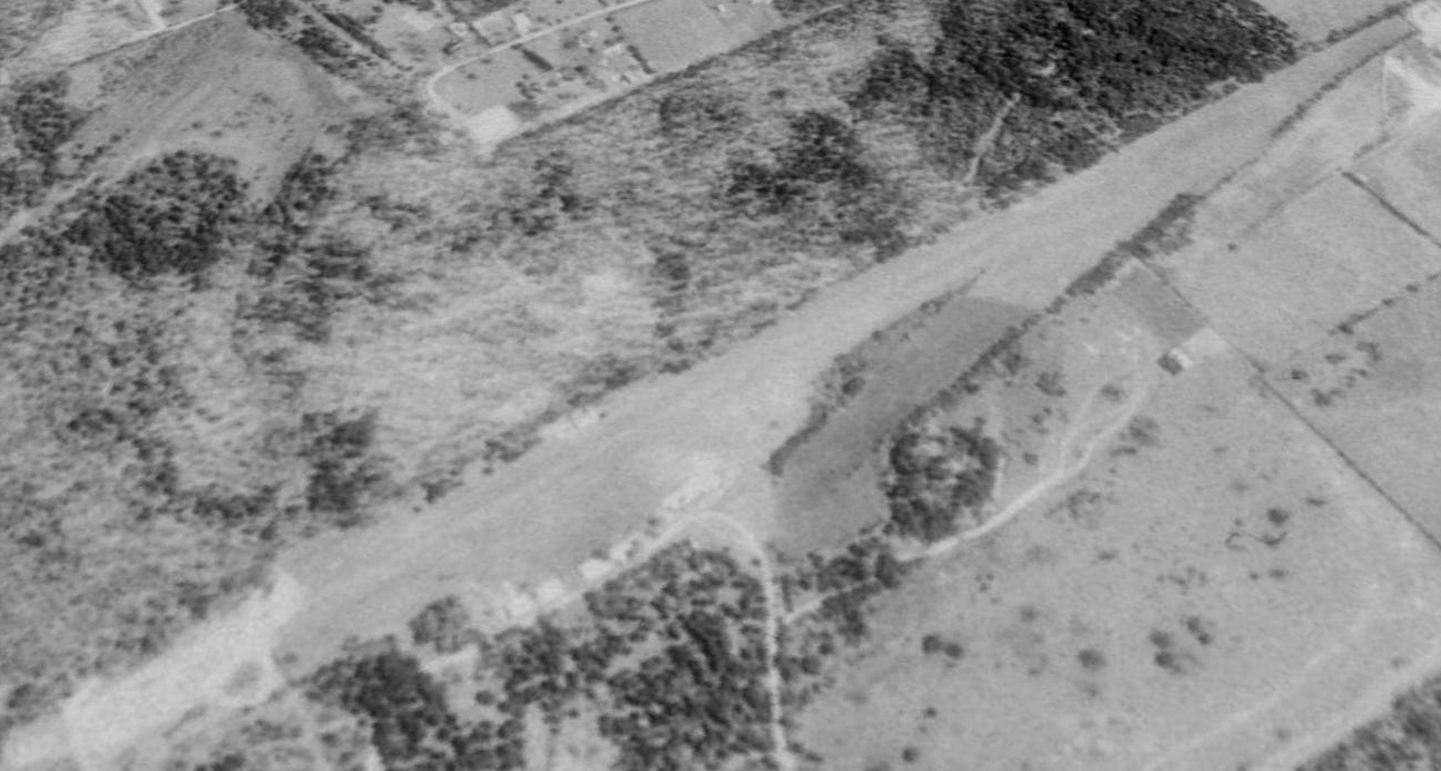
The earliest photo which is available of Miller Field was a 1989 aerial view looking east.
It depicted Miller Field as having a row of small hangars along the west side of a northwest/southeast grass runway.
There were no aircraft visible on the field.
For the year ending 10/24/94, the FAA Airport/Facility Directory described Miller Field as conducting an average of 17 takeoffs or landings per week.
Miller Field was not depicted at all on the 1996 USGS topo map.
Saundra Pancake reported, “Bill Pancake soloed grandson Michael Boggs on his 16th birthday on 7/4/04.
The earliest photo which is available showing aircraft at Miller Field was a 2007 aerial view looking east.
Two light single-engine aircraft were parked on the west side of the field.
Saundra Pancake reported, “Bill Pancake soloed grandson Curtiss Boggs on his 16th birthday on 10/30/08.”
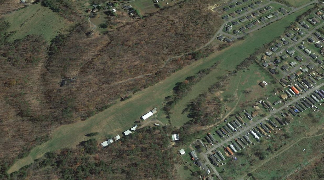
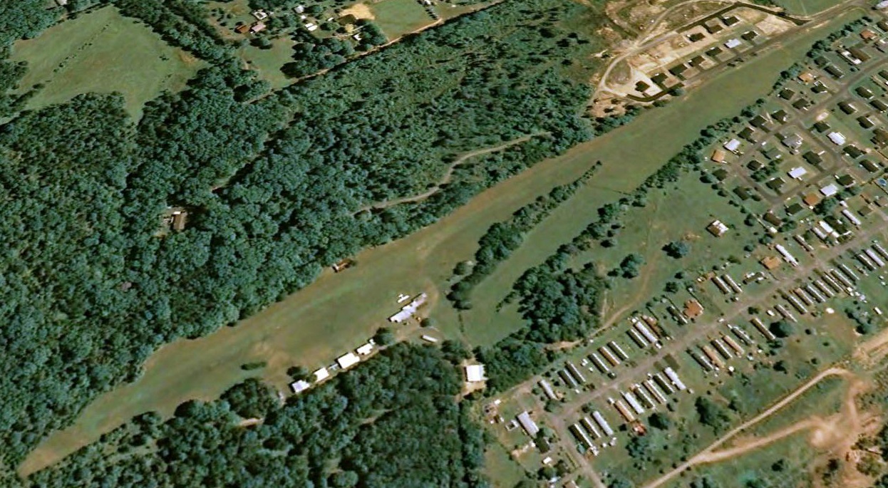
A 2016 aerial view looking east depicted Miller Field as having a row of small hangars along the west side of a northwest/southeast grass runway.
There were no aircraft visible on the field.
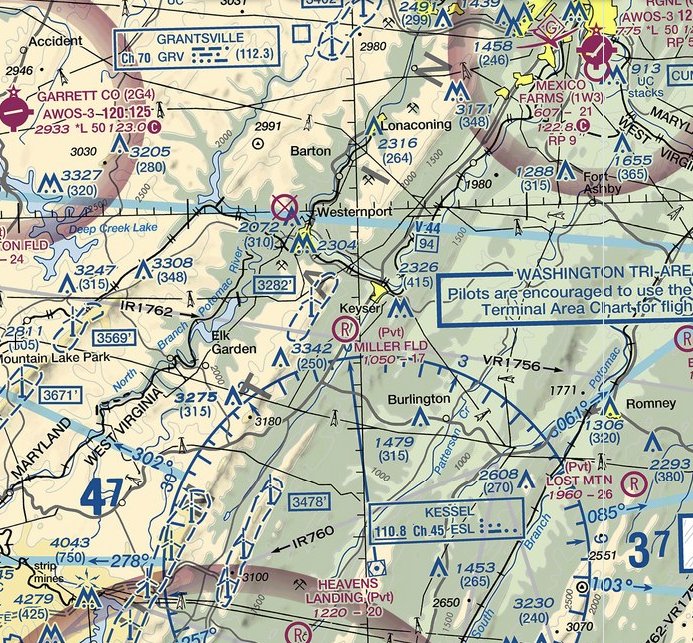
The 2021 Sectional Chart depicted Miller Field as a private airfield having a 1,700' unpaved runway.
As of 2021, the FAA Airport/Facility Directory described Miller Field as a private airfield owned by the Miller Family, and managed by Garold Garrett.
It was said to have a 1,700' turf Runway 15/33, described as “Runway rough & rolling, uphill to northwest & curving”, and to have 3 single-engine based aircraft.
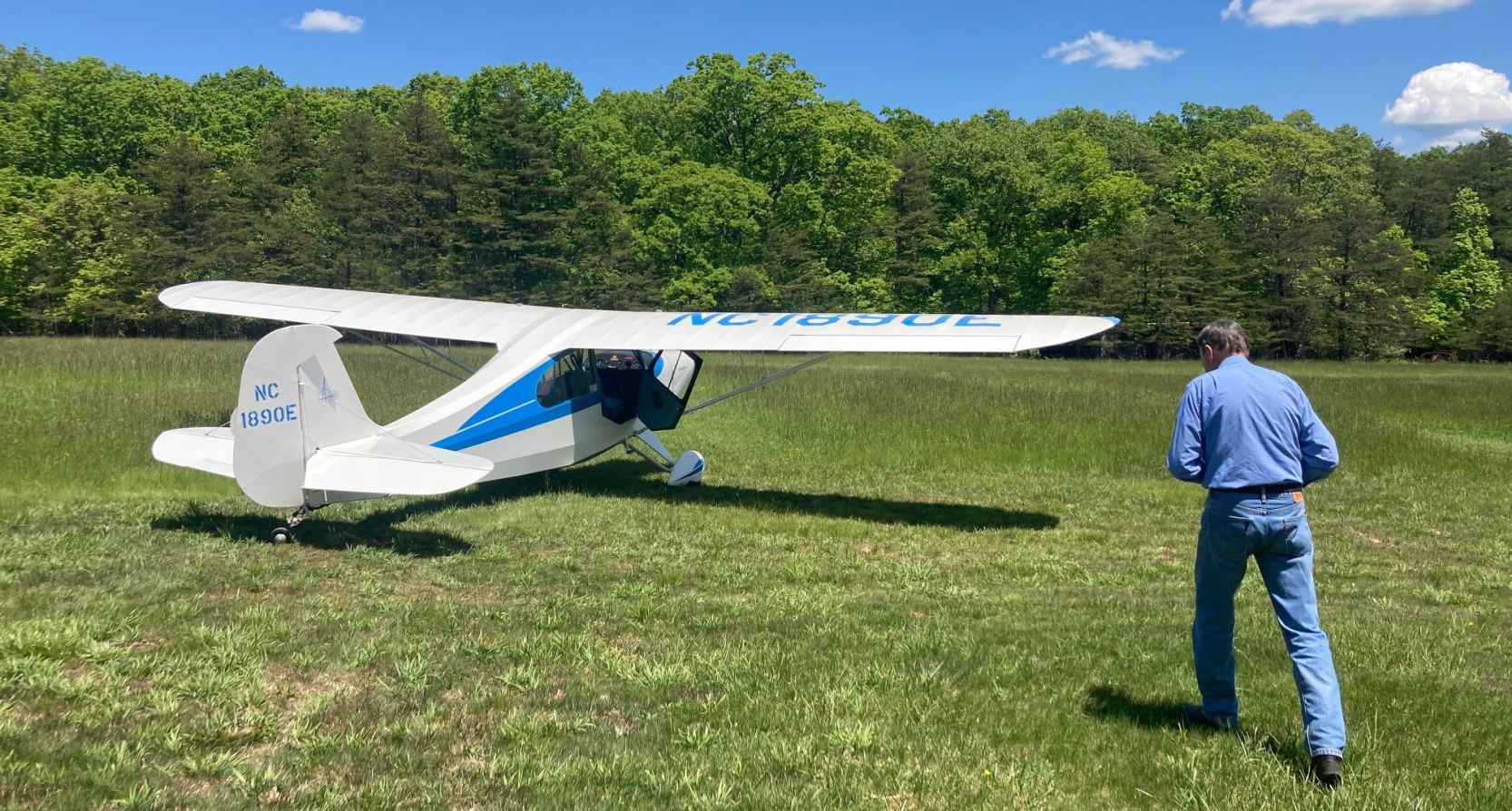
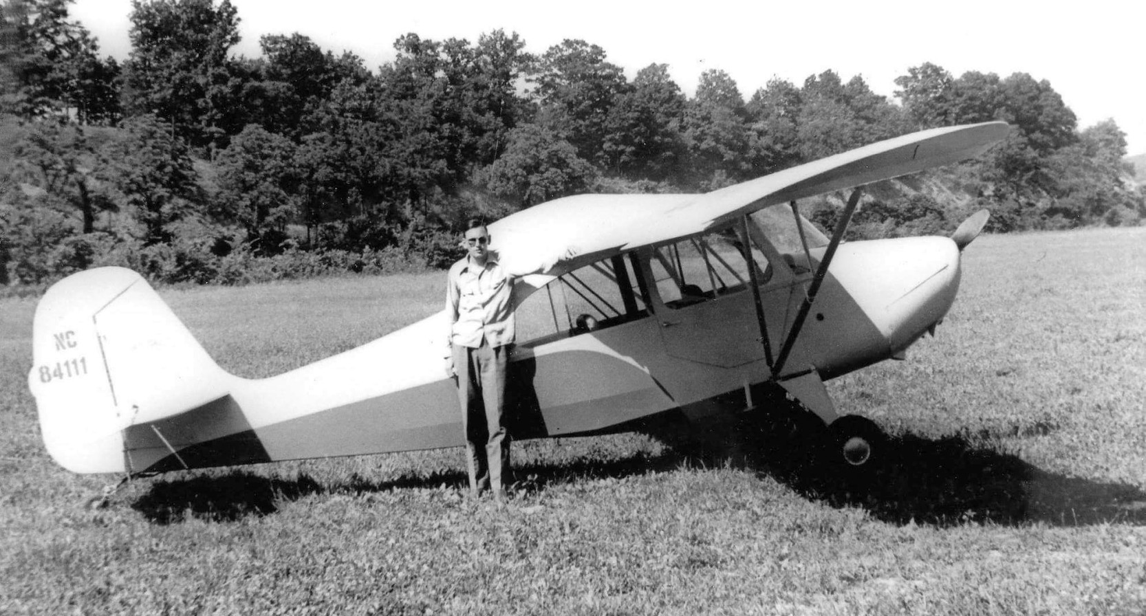
A 2021 photo of Bill Pancake walking to his Aeronca for the final departure after 65 years of flying off Miller Field.
A 2021 aerial view by Curtiss Boggs looking southeast at Miller Field, from his final flight from the field.
Note the closed-runway “X” symbol on the runway midpoint.
Unfortunately the end came for Miller Field in 2021, after 75 years of operation.
Saundra Pancake reported, “Last Thursday was a very sad day for our family. We were informed that the field was closing. It had been Bill Pancake's life.
The family does not want to assume liability after 65 years. There are only 2 airplanes there: Bill's & Keith Sines.”
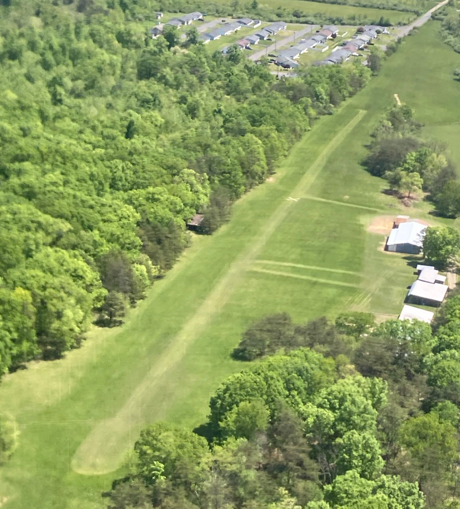
A 6/4/21 photo by Rick Harshbarger looking southeast along the former Miller Field runway.
Rick observed, “They've already got a cutting of hay off the runway. I can already see what it appears they're going to use the runway for... it's going to be used to make hay.”
A 6/4/21 photo by Rick Harshbarger looking northwest along the former Miller Field runway.
Rick observed, “The north & west ends are where the hangars were to the left and up the runway from my northwest facing picture.”
The site of Miller Field is located at the eastern terminus of Miller Airfield Lane, appropriately enough.
Thanks to Rich Harshbarger for pointing out this field.
____________________________________________________
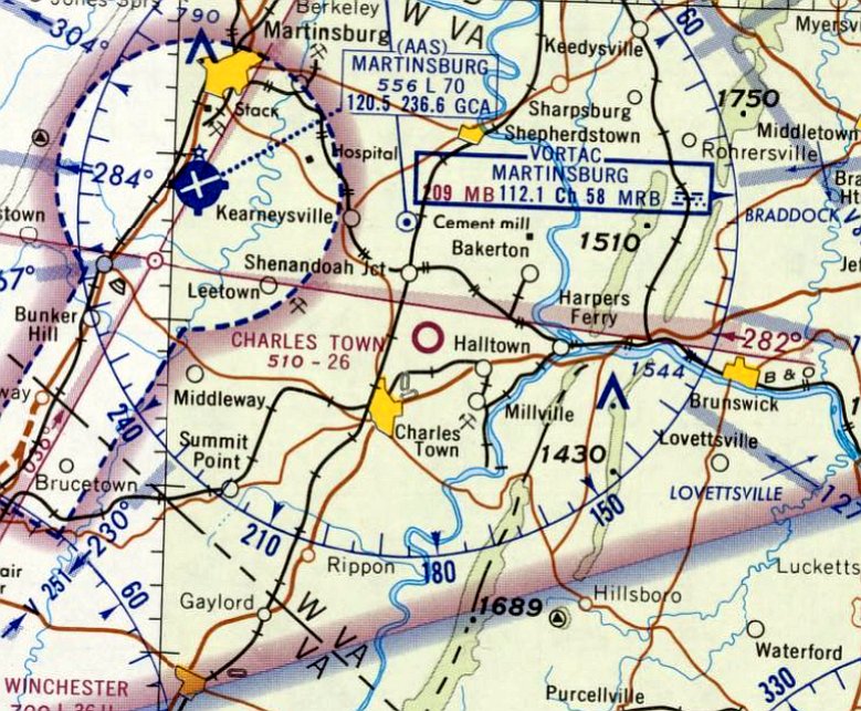
Charles Town Airport, Charles Town, WV
39.33, -77.833 (Northwest of Washington, DC)
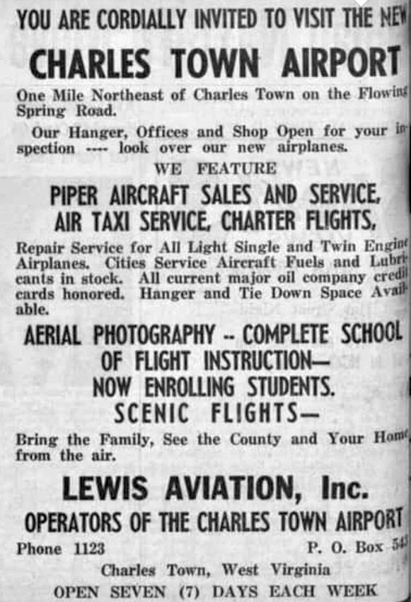
An advertisement for Lewis Aviation at the new Charles Town Airport, from the 1960 Spirit of Jefferson (courtesy of Mike Lee).
Photo of the airport while in use has not been located.
The short-lived Charles Town Airport was evidently established at some point in 1960,
as it was not yet depicted on the July 1960 Washington Sectional Chart.
The earliest reference which has been located to Charles Town Airport was an advertisement
for Lewis Aviation at the new Charles Town Airport in the 1960 Spirit of Jefferson (courtesy of Mike Lee).
It described the field as being 1 mile northeast of Charles Town on Flowing Springs Road,
and to have a hangar, offices, shops, fuel, Piper sales & service, air taxi, charter, tie downs, aerial photography, flight instruction, and scenic flights.
The operator was Lewis Aviation Inc.
Charles Town Airport was not depicted on the 1964 USGS topo map.
The earliest depiction which has been located of Charles Town Airport was on the 1964 Washington Sectional Chart.
It depicted Charles Town Airport as having a 2,600' unpaved runway.
The last depiction which has been located of Charles Town Airport was on the April 1965 Washington Sectional Chart.
It depicted Charles Town Airport as having a 2,600' unpaved runway.
The earliest photo which has been located of Charles Town Airport was a 1965 aerial view, perhaps taken after the airport's closure.
It depicted a single northeast/southwest unpaved runway, with 1 small hangar on the southwest side.
There were no aircraft visible on the field, nor any indication of recent aviation use.
Charles Town Airport evidently was closed at some point between 1965-66, lasting no more than only 6 years,
as it was no longer depicted on the March 1966 Washington Sectional Chart.
A 1969 aerial photo still showed signs of the Charles Town Airport runway.
Charles Town Airport was not depicted on the 1971 USGS topo map.
A 1974 aerial photo showed the runway had been plowed away, but the Charles Town Airport hangar remained standing.
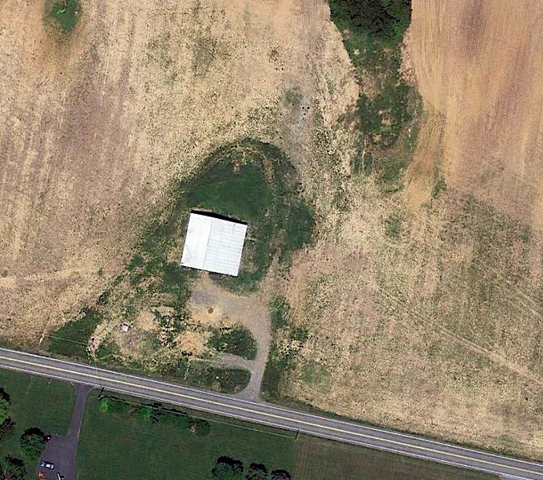
A 2013 aerial photo still showed the former Charles Town Airport hangar remained standing.
A July 2014 photo looking north still showed the former Charles Town Airport hangar remained standing, but construction was in progress which would soon remove it.
A later 2014 aerial photo showed the former hangar was removed at some point later in 2014, erasing the last trace of Charles Town Airport
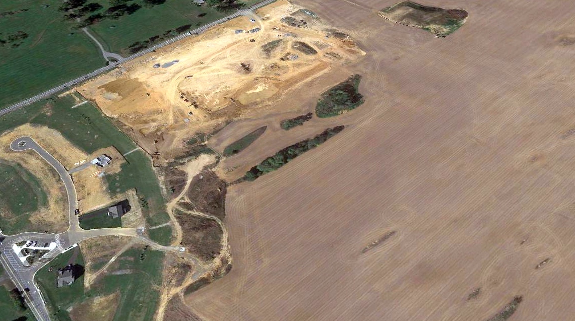
A 2017 aerial view looking northwest showed no trace of the former Charles Town Airport, with the property being covered by housing construction.
The site of Charles Town Airport is located northeast of the intersection of Flowing Springs Road & Country Club Road.
Thanks to Mike Lee for pointing out this airfield.
____________________________________________________
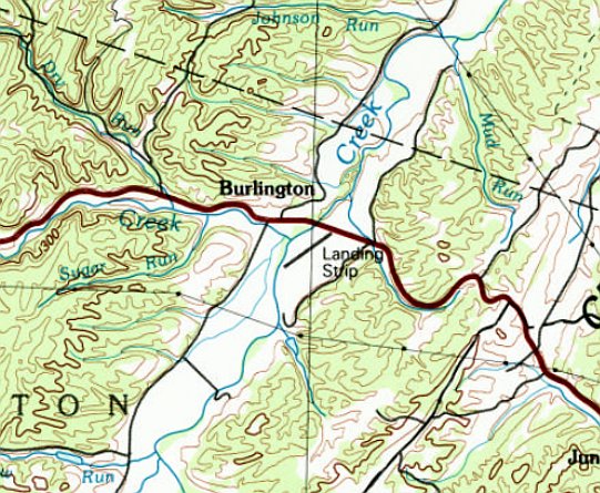
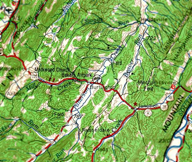
Woodworth Field, Burlington, WV
39.336, -78.909 (Northwest of Washington, DC)
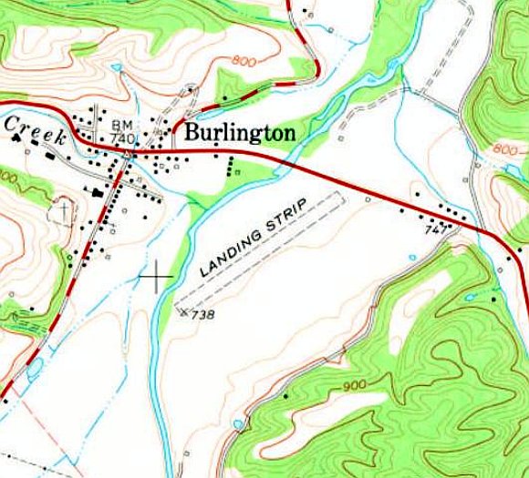
Woodworth Field, as depicted on the 1976 USGS topo map.
Woodworth Field was evidently constructed at some point between 1971-76,
as it was not yet depicted on a 1971 aerial photo.
The earliest depiction which has been located of Woodworth Field was on the 1976 USGS topo map,
which depicted a single unpaved northeast/southwest runway, labeled generically as “Landing Strip”.
Woodworth Field was not depicted on Washington Sectional Charts from 1978/81/94.
According to Rick Harshbarger, “This one is near & dear to me because of the owner
and my friendship with him & how he helped mentor my love for all things aviation.
Eugene Woodworth was one of the kindest gentlemen I ever had the pleasure to meet.
The field was constructed approximately 1978-80.
It was just east & across US Route 50 from the former Baker Air Park.
Woodworth Field was approximately 1,900' long.
Rick Woodworth (Eugene's son) remembers helping his Dad with grading the runway as a young boy.
There are 2 carport-like hangars. One for Eugene's 172 & later a 182 & another one I think put up by a Mr. Hadley who also had a Cessna there for a while.
I’ve seen many visitors in & out of the field over the years.”
Rick continued, “I was along for the ride when we landed an Apache at his field in Burlington.
Only 1,900' with trees at the south & powerlines and Route 50 on the north.
Landing wasn’t so scary but I don’t think we cleared the power lines by much when we departed.
Eugene was a County Farm Agent for the USDA in Petersburg WV.
Anytime the weather allowed it, he would fly the 20 minutes south from his field to Grant County Airport to get to work.
His children operate a large farm, Flying W Farm, and have a farm store & restaurant along Route 50 in Burlington.
Eugene & I had many a flying conversation sitting at one of their outdoor tables eating ice cream over the years.”
The 1983 USGS topo map depicted Woodworth Field as a single northeast/southwest runway, labeled generically as “Landing Strip”.
The earliest photo which has been located showing an aircraft at Woodworth Field was a 1986 aerial view.
It depicted Woodworth Field as having a single unpaved northeast/southwest runway, with 2 small buildings & a single-engine Cessna on the northeast side.
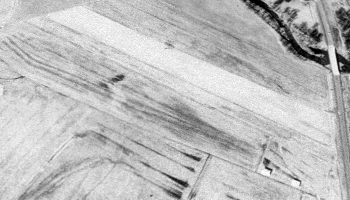
A 1989 aerial view looking southwest depicted Woodworth Field as a single northeast/southwest runway, with 2 small buildings on the northeast side.
The last photo which has been located showing an aircraft at Woodworth Field was a 1996 aerial view.
It depicted a single-engine Cessna on the northeast side.
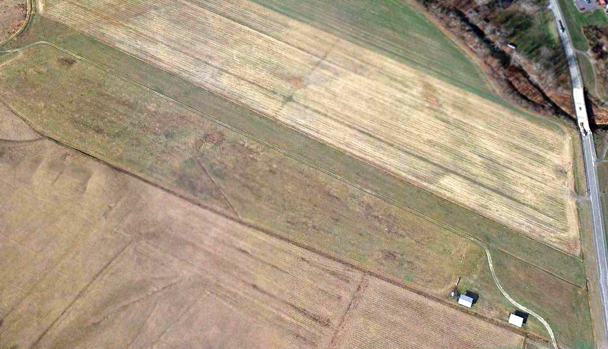
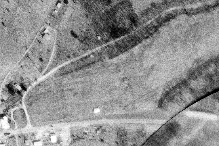
A 2013 aerial view looking southwest depicted Woodworth Field as a single northeast/southwest runway, with 2 small buildings on the northeast side.
Rick Harshbarger reported, “Sadly, in his 80s, Eugene Woodworth could no longer pass the FAA physical & was unable to fly anymore which upset him to be sure.
He & his son Rick still kept the runway mowed. My friend passed away on 3/17/18 at the age of 86. He was & is still missed greatly.”
A 4/20/20 photo by Rick Harshbarger looking south along the former Woodworth Field runway.
Rick Harshbarger reported in 2020, “I still pass the field everyday going to work. Rick still keeps the runway mowed.
Today both carport-like structures house farm equipment.
Although the field is not closed & is still mowed, it really ceased regular operation when Eugene could no longer fly his planes.
I’m still friends with the family & think of my friend Eugene Woodworth often.
He was one of a kind. May he rest in peace.”
A 4/20/20 photo by Rick Harshbarger looking southeast at one of the 2 former hangars at the site of Woodworth Field, with a windsock frame mounted on the left side.
A 4/20/20 photo by Rick Harshbarger looking southeast at one of the 2 former hangars at the site of Woodworth Field.
Thanks to Rick Harshbarger for pointing out this airfield.
____________________________________________________
39.328, -78.78 (Northwest of Washington, DC)
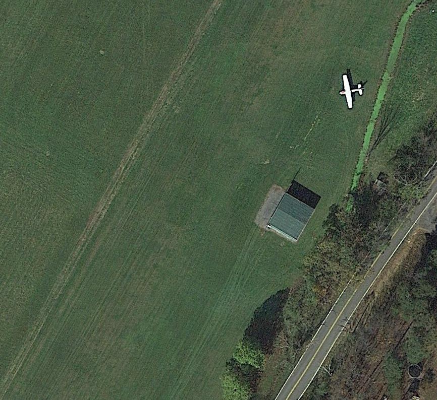
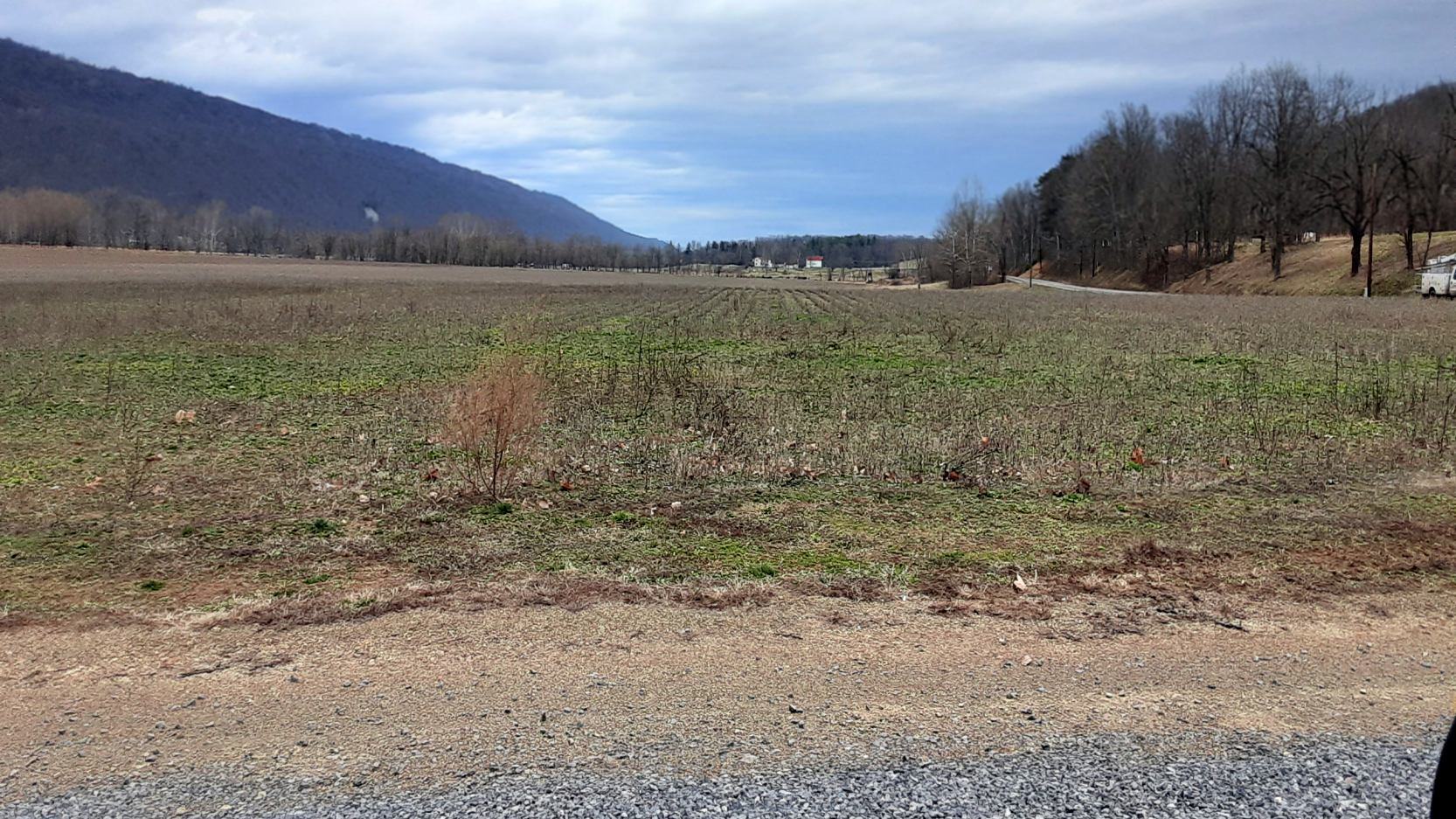
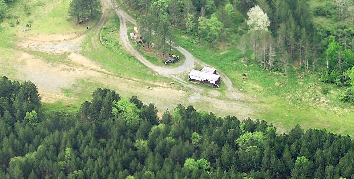
A 1993 aerial view looking northwest at Stump's Airfield.
This small private airfield was not yet depicted on a 1983 aerial photo.
According to Rick Harshbarger, “My estimate of the first year of operation [of Stump's Airfield] is 1983.
Henry Link had the first airplane (a homebuilt kit) at Stump Field.
He lost that plane when the river flooded during the great flood of 1985.”
The earliest depiction which has been located of Stump's Airfield was a 1993 aerial view, which depicted a northeast/southwest unpaved runway.
Stump's Airfield was not depicted on the March 1994 Washington Sectional Chart (courtesy of Ron Plante).
Rick Harshbarger reported, “Stump's Airfield... My good friend Dave Warner had his Cessna 172 there for years
and that's where I got my prescription for flying filled on a regular basis.
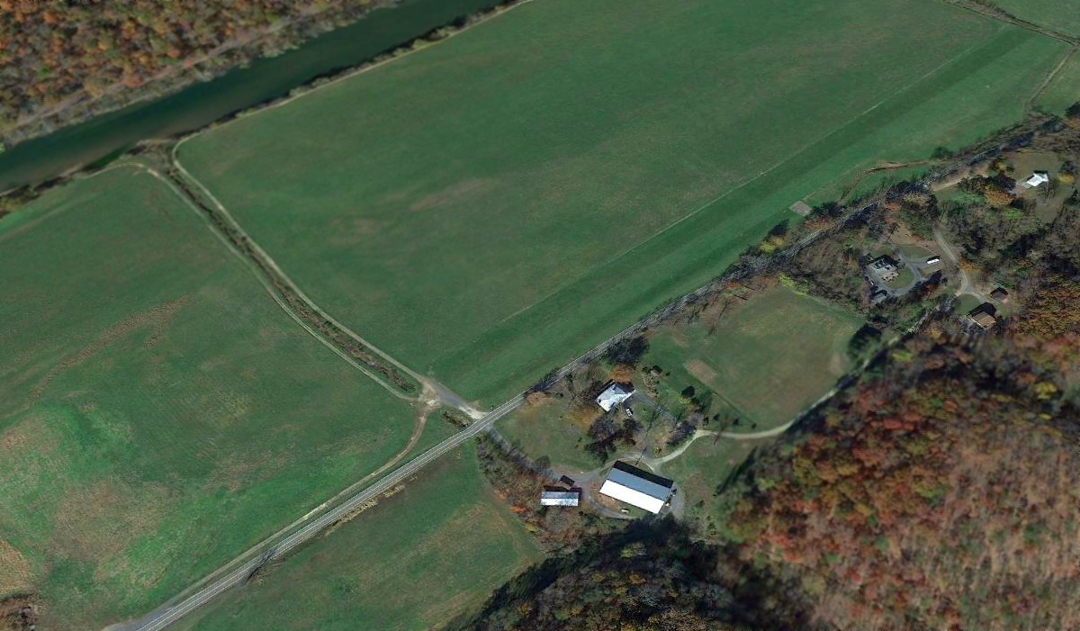
Stump's Field was a small farm airstrip serving Romney WV & was located parallel to River Road just west of town.
It was between the South Branch of the Potomac River & River Road.
It was named for the Stump family farm were it was located.
The runway was southwest/northeast & was approximately 2,000' long
with and additional overrun for larger twin-engine aircraft of 800' or so that was added by putting a large culvert in & covering it on the south end.
I saw a Cessna 310 use it for takeoff once; that was the only time I saw the extension used.
Stump's had runway lights that were controlled by microphone clicking on a certain radio frequency.”

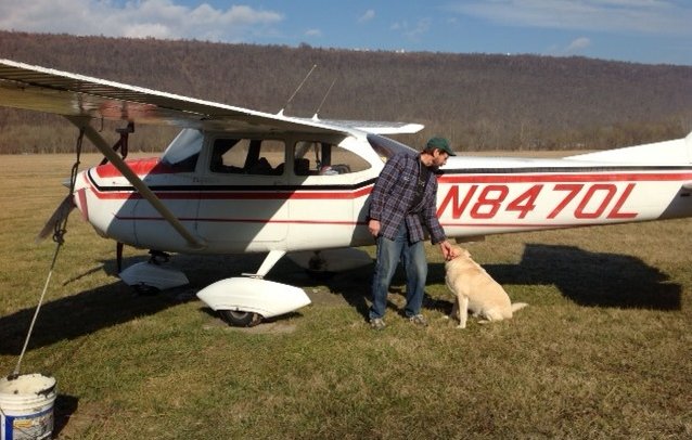
The earliest photo which has been located of an aircraft at Stump's Field was a 1997 photo by Bob Steele (courtesy of Rick Harshbarger) of David Warner departing to the north from Stumps Field in Cessna 172 N8470L.
Rick Harshbarger observed, “Notice one of the runway lights at the bottom-right.”
A circa 2000-2020 photo courtesy of David Warner of David & his original Cessna 172 N8470L at Stump's Airfield.
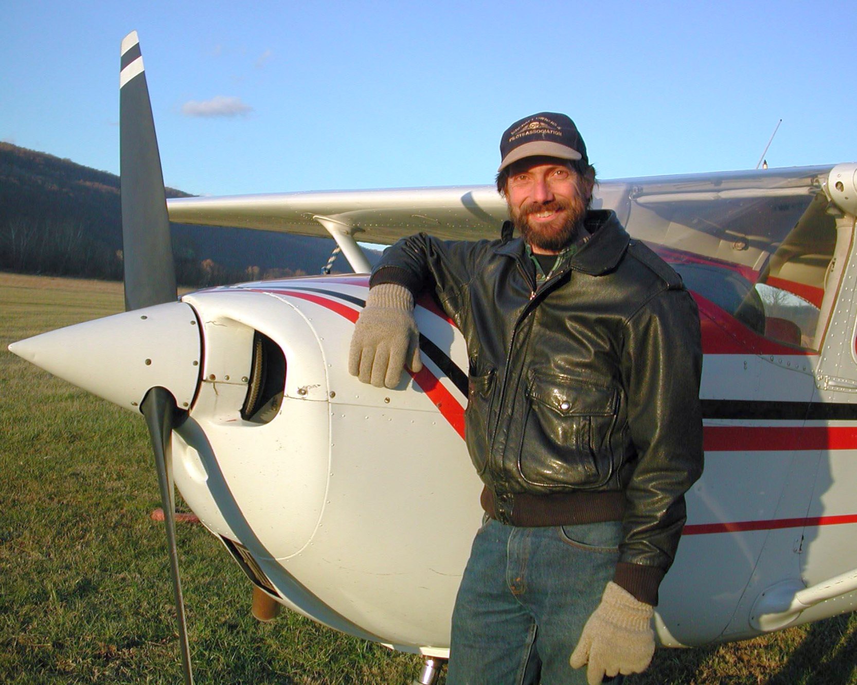
A circa 2000-2020 photo courtesy of David Warner of David & his original Cessna 172 N8470L at Stump's Airfield.
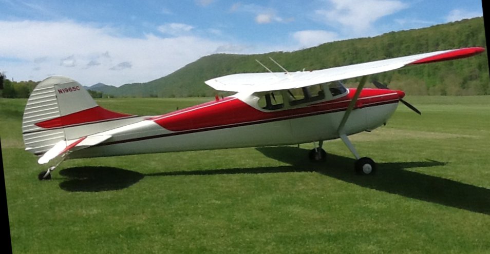
A circa 2000-2020 (courtesy of David Warner) looking south at a nice visiting Cessna 170 at Stump's Airfield.
David Warner recalled, “Flying into Stumps from the north, especially with a strong westerly wind,
the flow of air coming through the gap in the mountain just to the west was like flying through the turbulent flow from a water hose.
If one could stand it & keep descending until on short final over the trees, you'd escape that & enter a calm in the river valley that made the actual landing easy.
It was just the approach that was a bit alarming.”
A 2002 aerial view of Stump's Airfield depicted David Warner's Cessna 172 parked on the east side of the Stump's Airfield runway.
An October 2013 aerial view of Stump's Airfield depicted David Warner's Cessna 172 parked on the east side of the Stump's Airfield runway,
and showed that a small hangar had been constructed on the east side of the runway midpoint at some point between 2002-2013.
Stump's Airfield was not depicted on the 2014 USGS topo map, or the 2016 Washington Sectional Chart.
A 2016 aerial view looking northwest at Stump's Airfield showed the runway was still distinct, but there were no aircraft visible on the field,
and the small hangar on the east side of the runway midpoint had been removed at some point between 2013-2016, with only its foundation remaining.
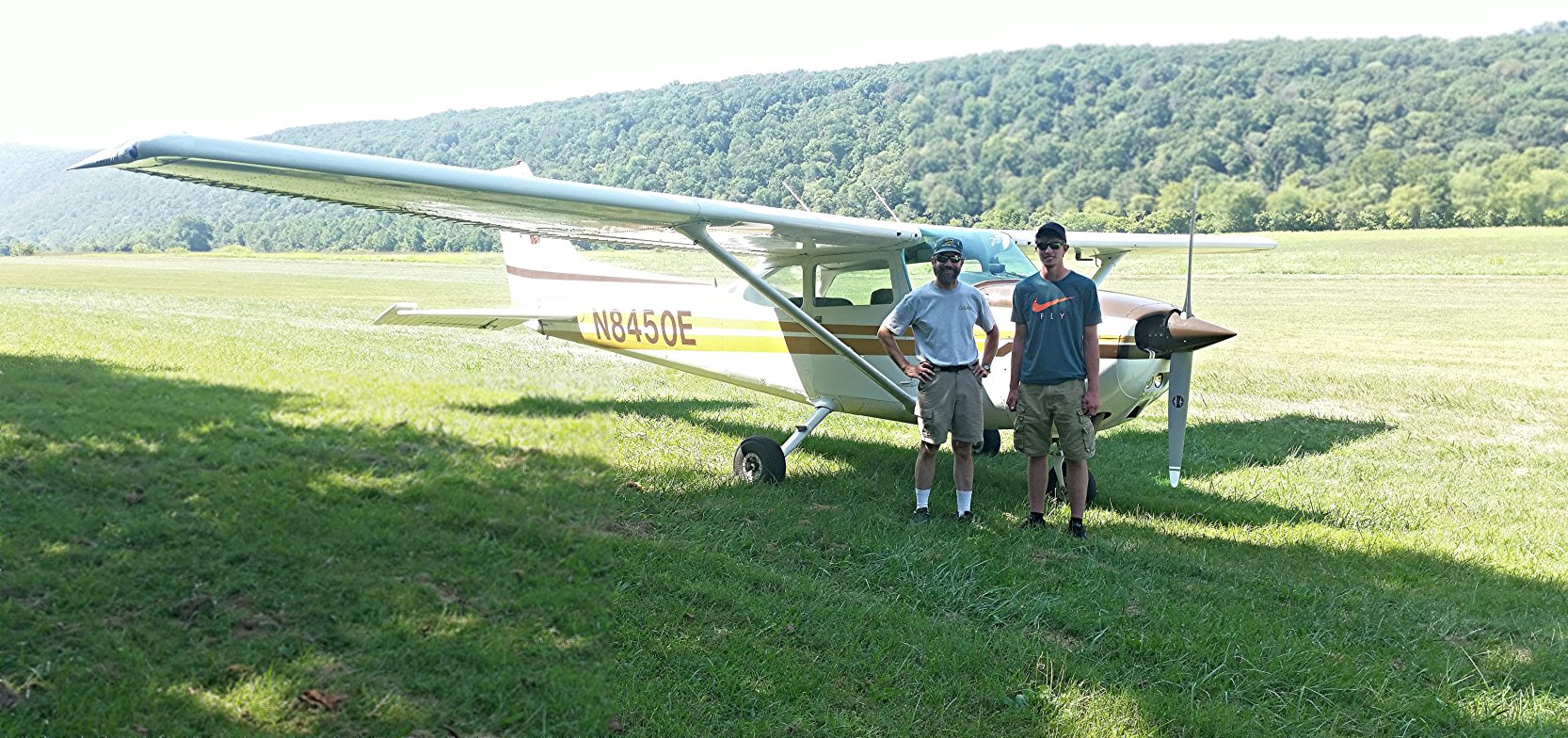
A circa 2017 photo courtesy of David Warner of David & young aviation fan in front of David's newer Cessna 172 N8450E at Stump's Airfield.
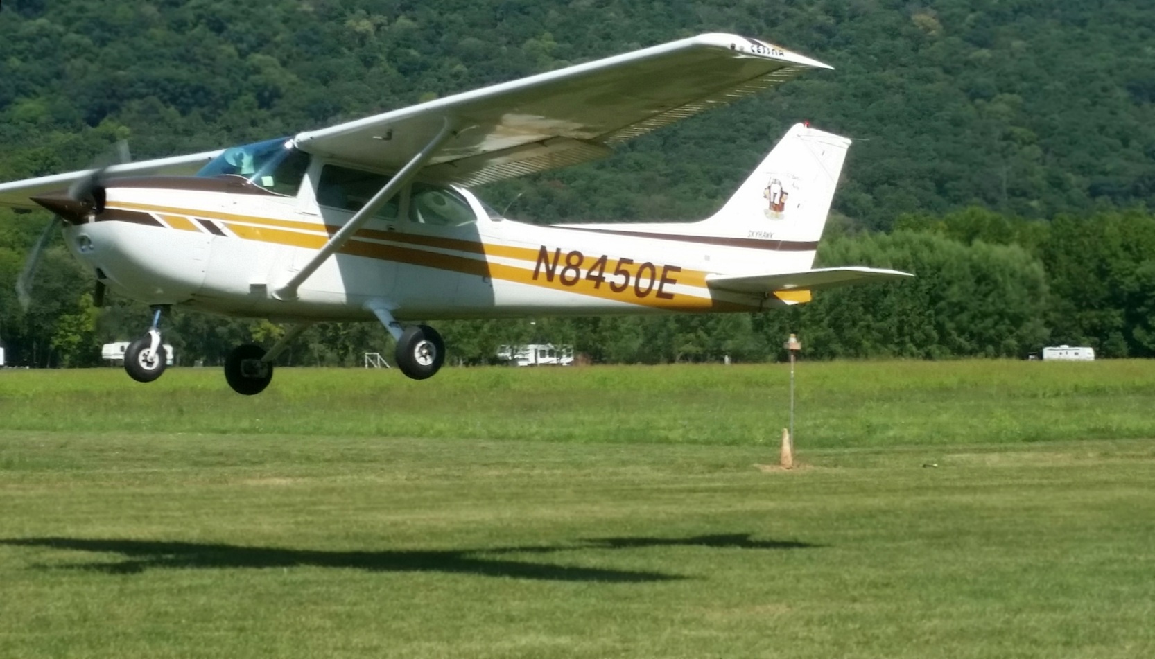
A circa 2017 photo courtesy of David Warner of David & his newer Cessna 172 N8450E taking off southbound from Stump's Airfield.
Rick Harshbarger reported, “My good friend Dave Warner, his Cessna 172 was the last plane based at Stump's Field.
The field was closed in 2020 when it was planted in beans by new owners.”
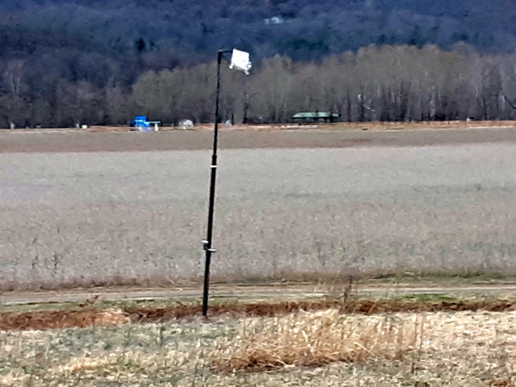
A March 2020 photo by Rick Harshbarger of the remains of the Stump's Airfield windsock.
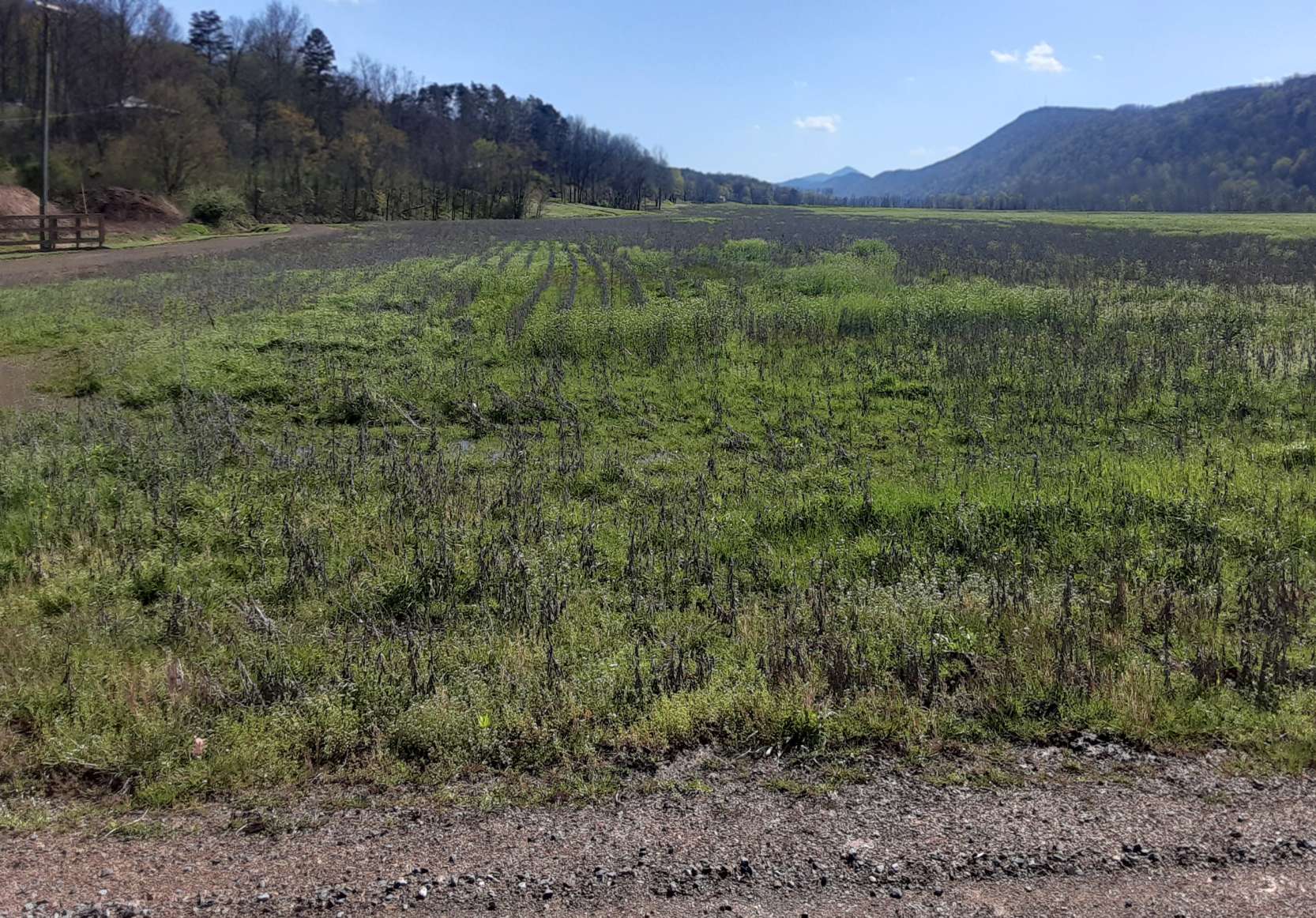
A March 2020 photo by Rick Harshbarger looking north along the remains of the Stump's Airfield runway, with beans starting to come up.
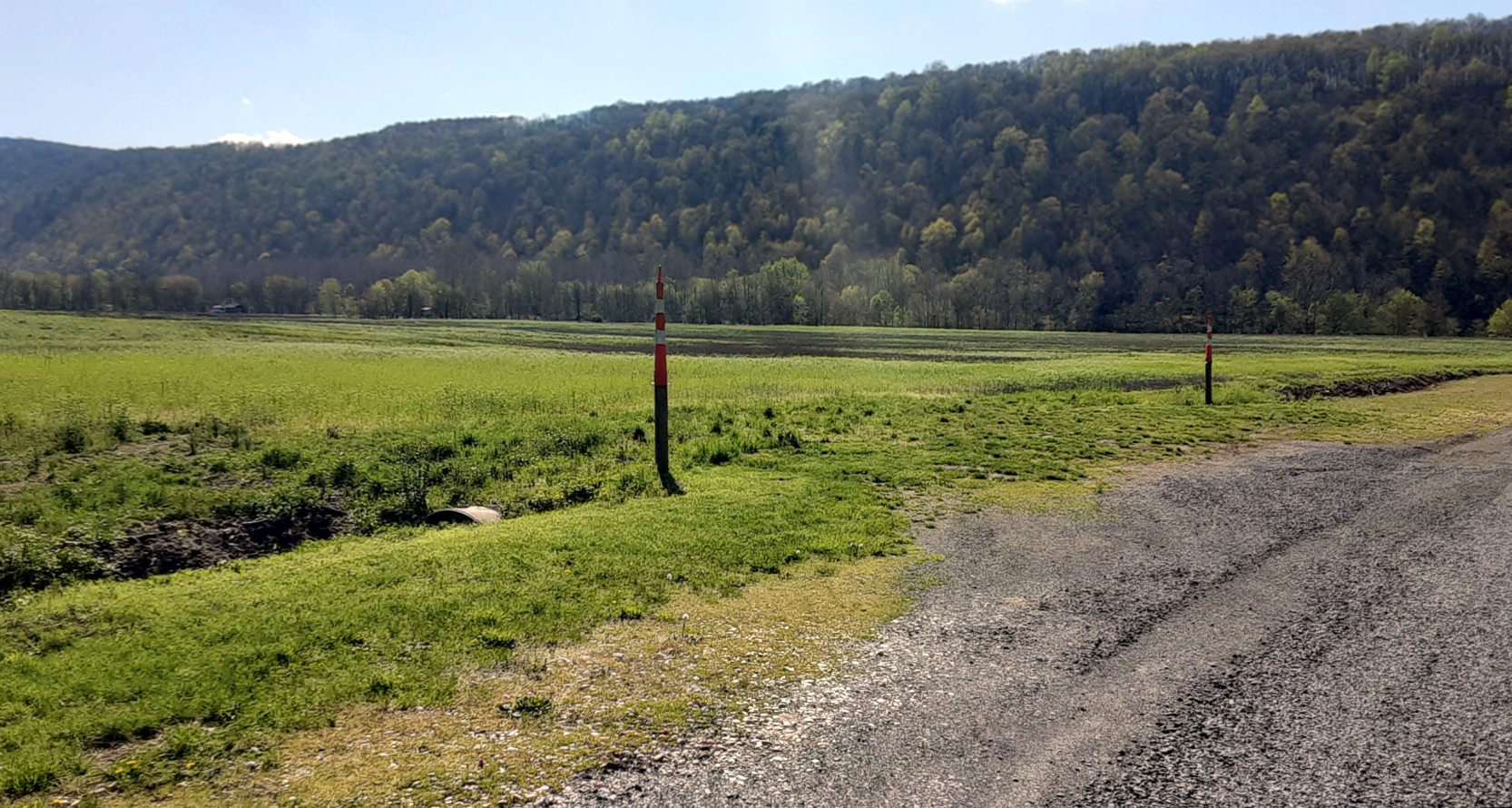
A 4/15/20 photo by Rick Harshbarger of 2 posts with an orange & white cone over each that marked the southern threshold of the Stump's Airfield runway.
A 4/15/20 photo by Rick Harshbarger looking south from the Northern threshold of the former Stump's Airfield runway.
A 4/15/20 photo by Rick Harshbarger looking east of the former Stump's Airfield hangar across River Road to the east where the planes would taxi across the road to reach the runway.
Thanks to Rick Harshbarger for pointing out this airfield.
____________________________________________________
Summit Point Airport, Summit Point, WV
39.247, -77.988 (Northwest of Washington, DC)
A 1997 aerial view looking northwest at Summit Point Airport.
This small private airfield was evidently constructed at some point between 1980-90,
as it was not yet depicted on a 1980 aerial photo.
The earliest depiction which has been located of Summit Point Airport was on a 1990 aerial view,
which depicted the beginnings of a northeast/southwest unpaved runway under construction, with a single small building (a hangar?) at the northeast end.
A 1997 aerial view depicted Summit Point Airport as having a northeast/southwest unpaved runway,
and a long hangar had been added on the east side at some point between 1990-97.
Summit Point Airport was not depicted at all on the 2001 USGS topo map.
In 2005, the Cedar Meadows Airpark was constructed adjacent to the south end of the Summit Point Airport runway,
on the opposite side of the railroad tracks.
Strange to have 2 small airfields directly adjacent to each other, and with their runways almost perpendicular.
Summit Point Airport was not depicted at all on the 2013 USGS topo map.
The only photo which has been located showing aircraft at Summit Point Airport was a 2013 aerial view looking southwest.
Two light single-engine aircraft were visible, one on either side of the runway.
A 2015 aerial view looking northwest at Summit Point Airport showed it remained intact, but no aircraft were visible on the field.
Summit Point Airport was not depicted on the 2016 Washington Terminal Aeronautical Chart or on the 2016 USGS topo map,
nor was it listed with the FAA as of 2020.
____________________________________________________
Cedar Meadows Airpark, Summit Point, WV
39.243, -77.992 (Northwest of Washington, DC)
A 2005 aerial view looking northeast showed the Cedar Meadows Airpark runway under construction.
This residential airpark was evidently constructed at some point between 2003-2005,
as it was not yet depicted on a 2003 aerial photo.
The earliest depiction which has been located of Cedar Meadows Airpark was on a 2005 aerial view,
which depicted the unpaved east/west runway under construction.
Strangely, the somewhat older Summit Point Airport was located adjacent to the north side of the Cedar Meadows Airpark runway,
on the opposite side of the railroad tracks.
Strange to have 2 small airfields directly adjacent to each other, and with their runways almost perpendicular.
Cedar Meadows Airpark was not depicted at all on the 2013 USGS topo map.
As of 2014, the Cedar Meadows Airpark website said that the construction phase of the airpark was complete, with 18 residential lots sold.
Four homes had been built, alongside a 3,000' grass strip, and the airfield identifier was being submitted to the FAA.
A 2015 aerial view looking northeast showed Cedar Meadows Airpark as having an east/west grass runway, with several homes along the south side.
There were no aircraft visible on the field.
Cedar Meadows Airpark was not depicted on the 2016 Washington Terminal Aeronautical Chart or on the 2016 USGS topo map,
nor was it listed with the FAA as of 2020.
____________________________________________________
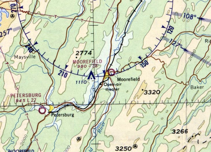
Moorefield Airport, Moorefield, WV
39.07, -78.947 (Northwest of Washington, DC)
Moorefield Airport, as depicted on the May 1944 Huntington Sectional Chart.
This little general aviation airport was evidently established at some point between 1942-43,
as it was not yet depicted on the November 1942 Huntington Sectional Chart.
The earliest reference which has been located to Moorefield Airport was its listing in a 1943 Directory of Airfields (courtesy of Scott Murdock, via Jonathan Westerling).
The earliest depiction which has been located of Moorefield Airport was on the May 1944 Huntington Sectional Chart.
It depicted Moorefield as a commercial/municipal airport.
The earliest photo which has been located of Moorefield Airport was an undated aerial view looking northeast from the 1945 AAF Airfield Directory (courtesy of Scott Murdock, via Jonathan Westerling).
It depicted Moorefield Airport as having 2 unpaved runways in an X-shape.
The 1947 Decker Guide to the Southeast States (courtesy of Jonathan Westerling) described Moorefield Airport
as having 2 sod runways measuring 2,800' northwest/southeast & 2,500' east/west.
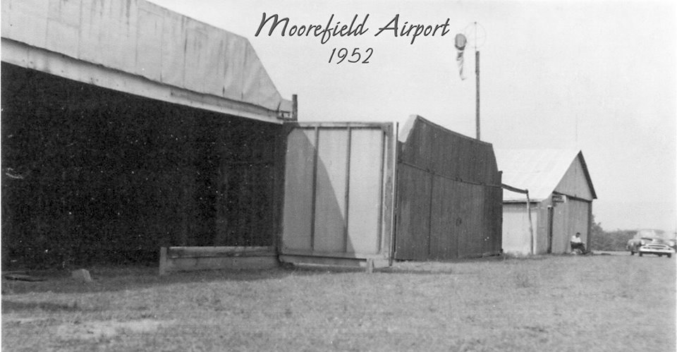
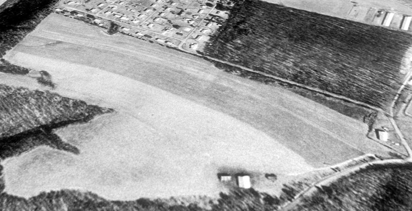
The earliest ground-level photo which has been located of Moorefield Airport was a 1952 photo (courtesy of Rick Harshbarger) of a row of hangars.
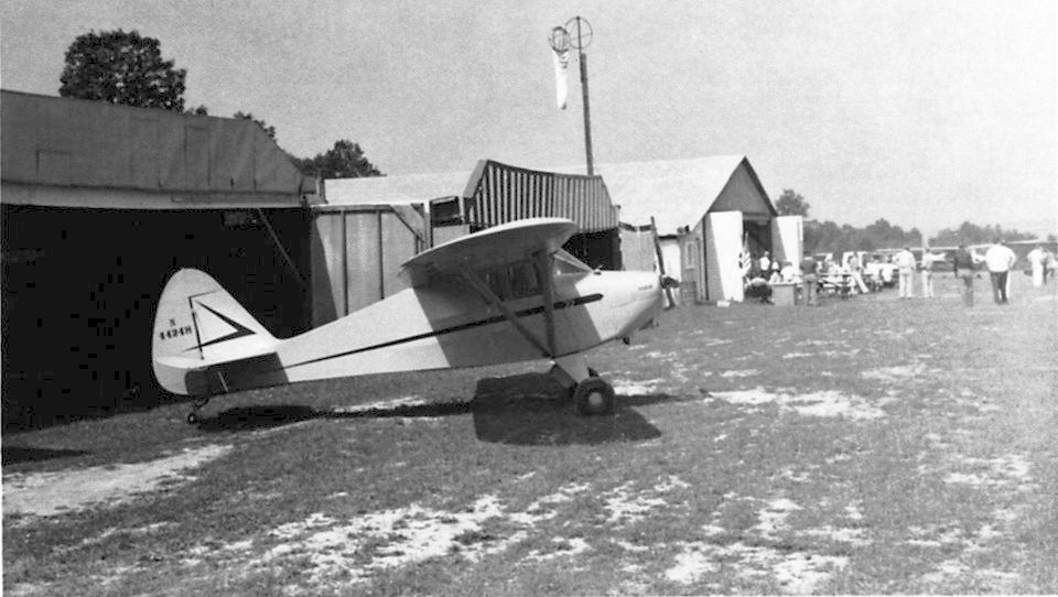
The only photo which has been located showing an aircraft at Moorefield Airport was a June 1960 photo (courtesy of Rick Harshbarger) of a Piper Vagabond PA-15 N4424H in front of the row of hangars.
Rick Harsbarger reported, “Moorefield Airport was called one of the busiest grass strips in WV.”
A 3/16/66 USGS aerial view depicted Moorefield Airport as having a grass northwest/southeast runway, with 4 small buildings/hangars on the southeast side.
There were no aircraft visible on the field.
Strangely, Moorefield Airport was not depicted at all on the 1966 USGS topo map.
The last aeronautical chart depiction which has been located of Moorefield Airport was on the February 1969 Huntington Sectional Chart.
It depicted Moorefield Airport as having a 2,800' unpaved runway.
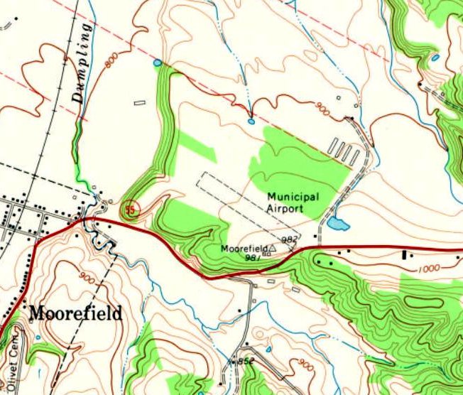
The earliest topo map depiction which has been located of Moorefield Airport was on the 1970 USGS topo map.
It depicted Moorefield “Municipal Airport” as having a single unpaved northwest/southeast runway, with 1 small building on the southeast side.
The last airport directory depiction which has been located of Moorefield Airport was in the 1975 Flight Handbook (courtesy of Jonathan Westerling).
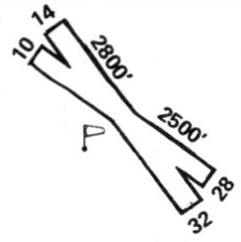
It depicted Moorefield Airport as having 2 unpaved runways ( 2,800' northwest/southeast & 2,500' east/west) in an X-shape.
However, the listing said “Airport is permanently closed, soon to be abandoned (5/75).”
Moorefield Airport was no longer depicted on the March 1978 Washington Sectional Chart.
According to Rick Harsbarger reported, “Folks used the new lighted paved strip in Petersburg & this one died out.”
The last reference that can be found to Moorefield Airport was in the 1979 WV Airport Directory (courtesy of Rick Harshbarger).
It described Moorefield Municipal Airport as being managed by William Harper,
and to have 2 turf runways (2,800' runway 14/32 & 2500' Runway 10/28), which is odd since previous depictions only showed a single runway.
It was also said to have a hangar & tiedowns.
According to Rick Harshbarger, Moorefield Airport was no longer listed in the 1980 WV Airport Directory or further editions.
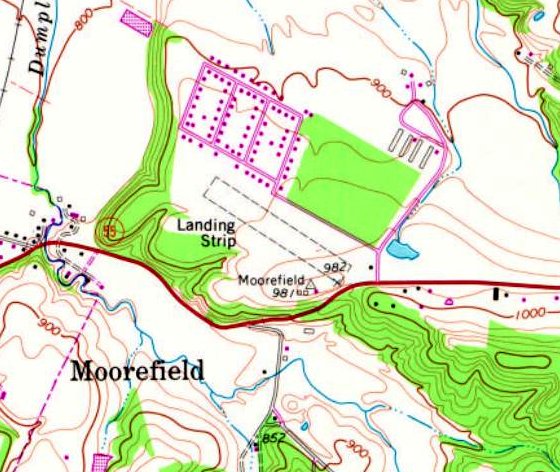
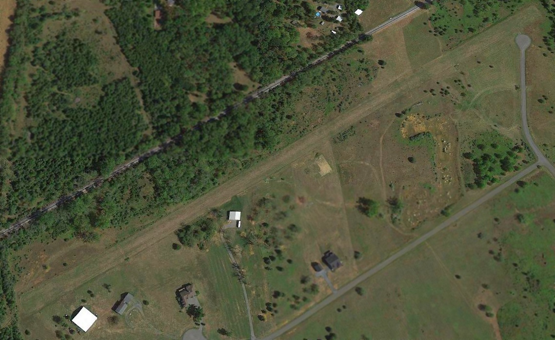
The former Moorefield Airport runway still depicted on the 1981 USGS topo map,
but it was labeled generically as “Landing Strip”.
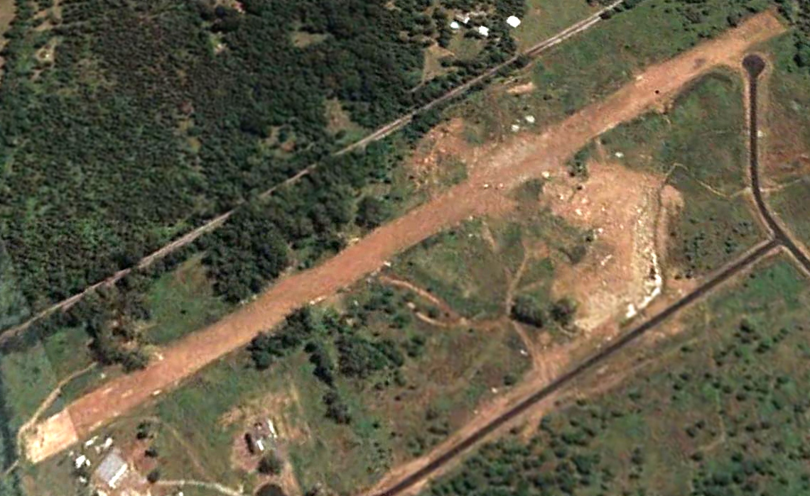
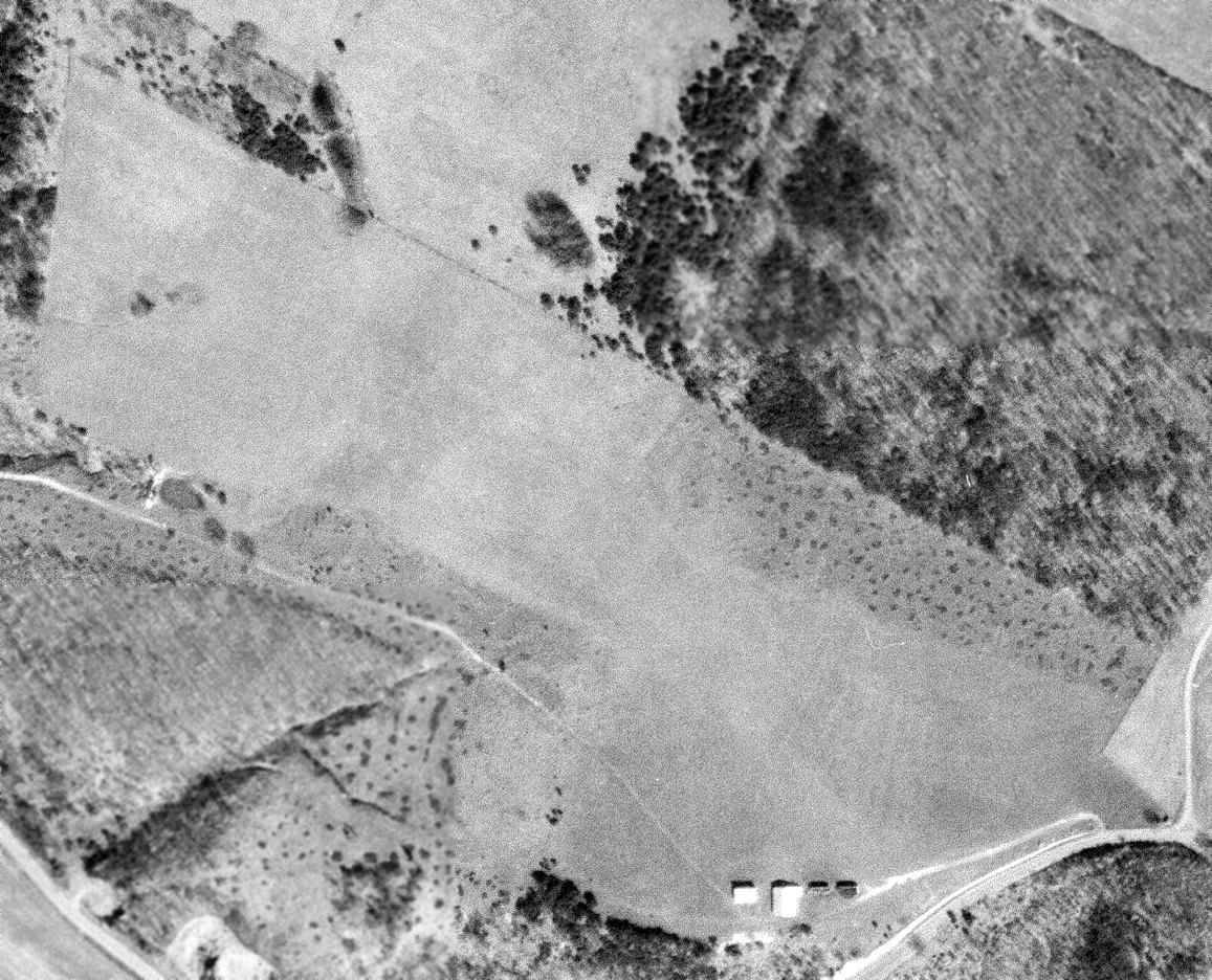
A 1991 USGS aerial view looking north depicted the former grass runway at Moorefield Airport as still remaining clear, but appearing to have been returned to cultivation.
Three of the 4 former hangars remained on the southeast side.
A 2003 aerial view showed that a school had been built at some point between 1991-2003 on the southeast portion of the Moorefield Airport site,
erasing the remnants of this little airport.
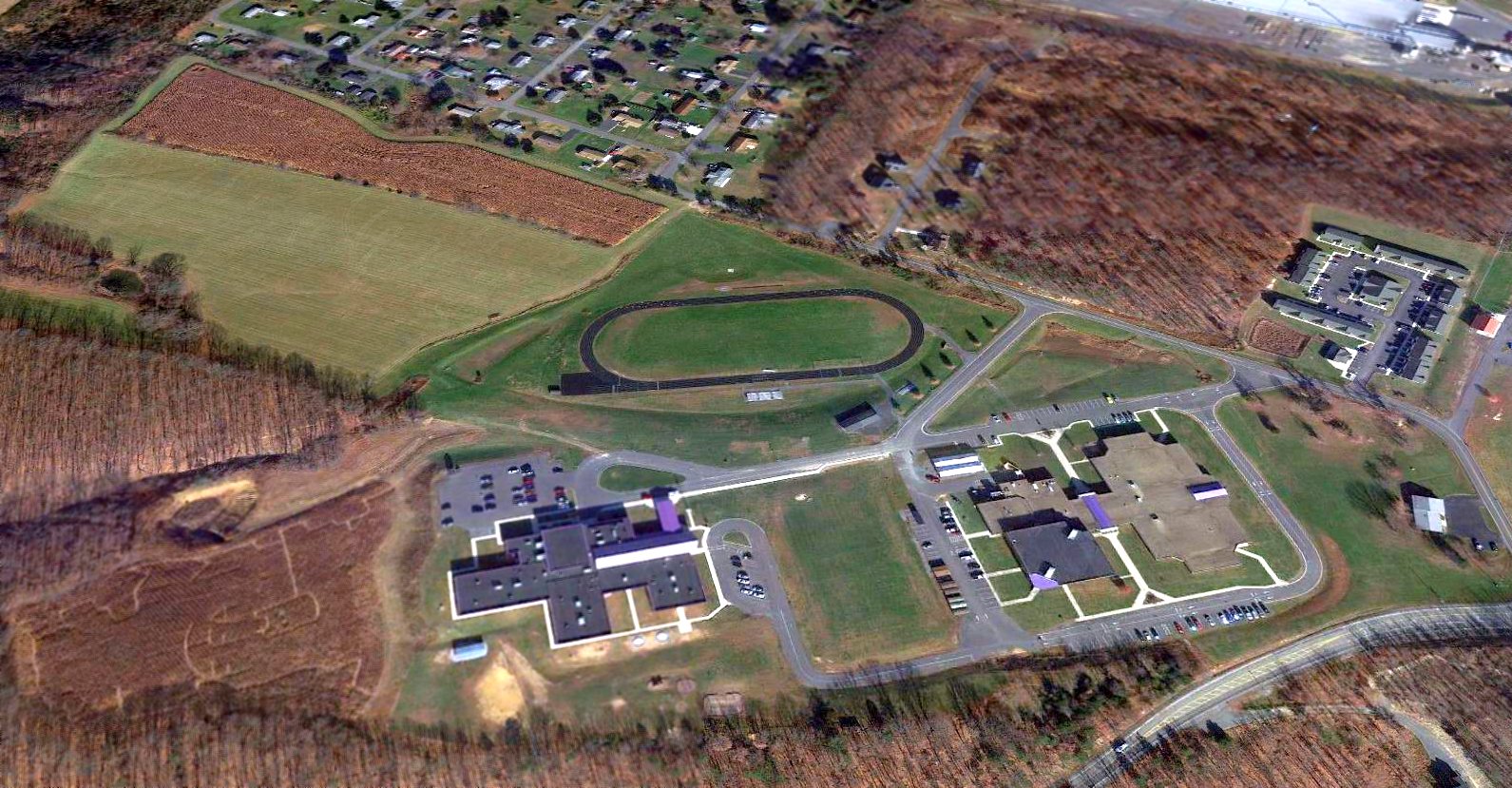
A 2013 aerial view looking north showed Moorefield Intermediate School & Moorefield Middle School occupying the southern portion of the Moorefield Airport site.
The only trace remaining of the little airport is the shape of the clearing of the northwest end of the runway.
Thanks to Rick Harshbarger for pointing out this airfield.
____________________________________________________
39.16, -79.51 (Northwest of Washington, DC)
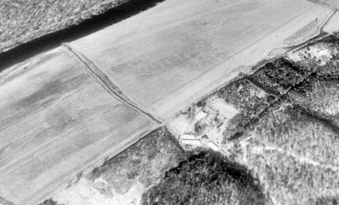
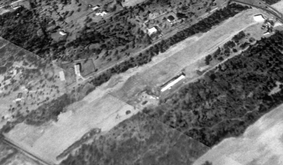
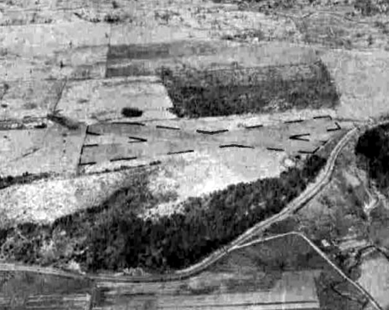
A 4/12/56 USGS aerial photo depicted Thomas Airfield as having a single unpaved northwest/southeast runway.
Not much is known about this small rural airfield, including its date of construction, purpose, or name.
The earliest depiction which has been located of Thomas Airfield was a 4/12/56 USGS aerial photo,
which depicted a single unpaved northwest/southeast runway.
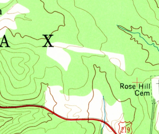
The 1959 USGS topo map depicted the northwest/southeast clearing of the Thomas Airfield runway, but did not label the airfield.
The Thomas Airfield was not depicted at all on the 1960 Huntington Sectional Chart.
The 1995 USGS topo map depicted Thomas Airfield as a single northwest/southeast runway, labeled simply as “Landing Strip”.
The Thomas Airfield was not depicted at all on the July 2001 Cincinnati Sectional Chart (courtesy of Rick Harshbarger).
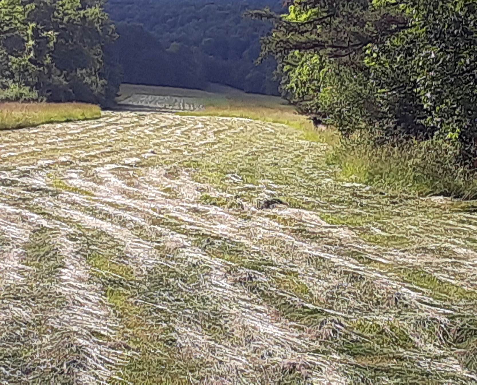
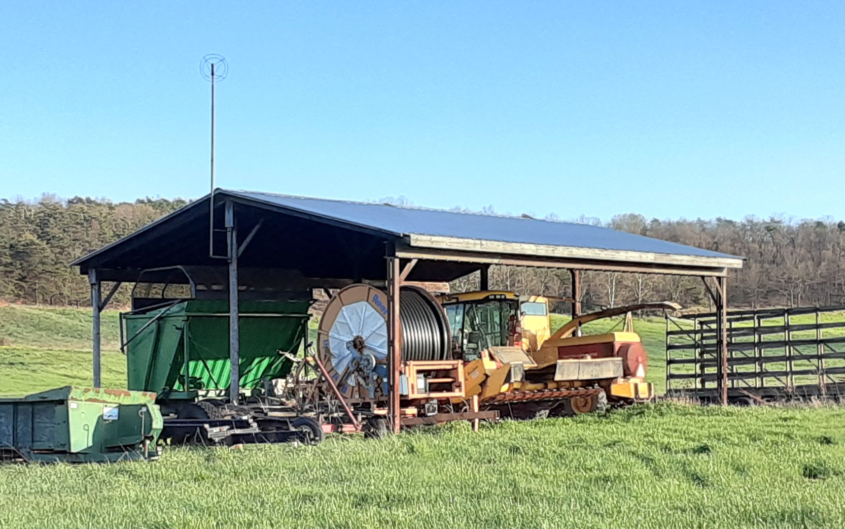
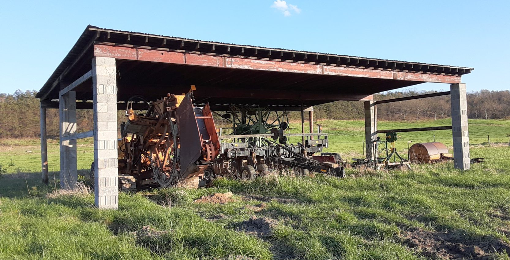
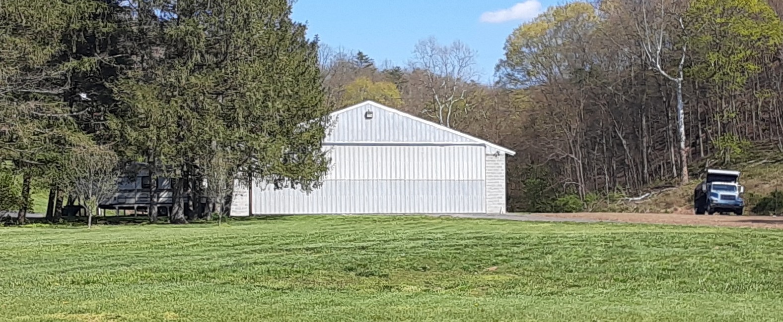
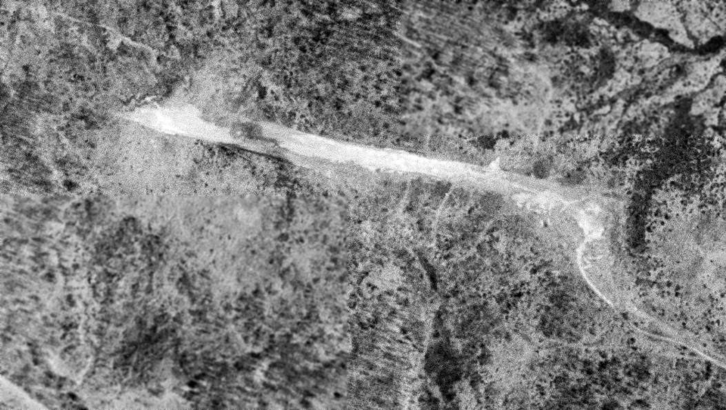
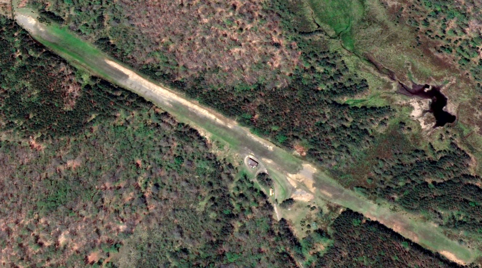
A circa 2010 aerial view looking south depicted a single T-hangar on the south side of the Thomas Airfield runway.
The T-hangar appeared to be open on the north side, but it was not evident if there was an aircraft inside.
As of 2015, there was no airfield in Thomas registered with the FAA.
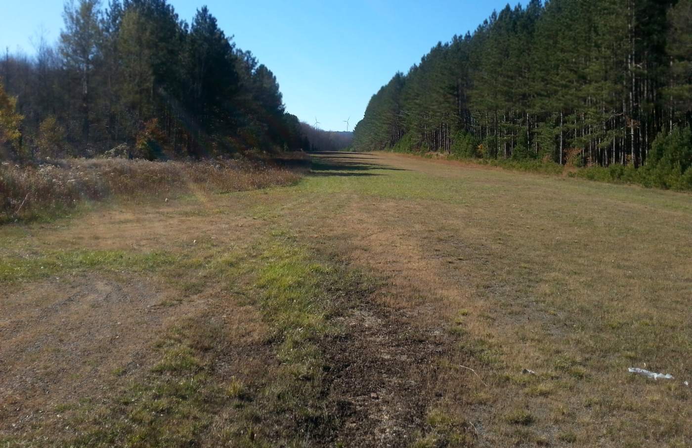
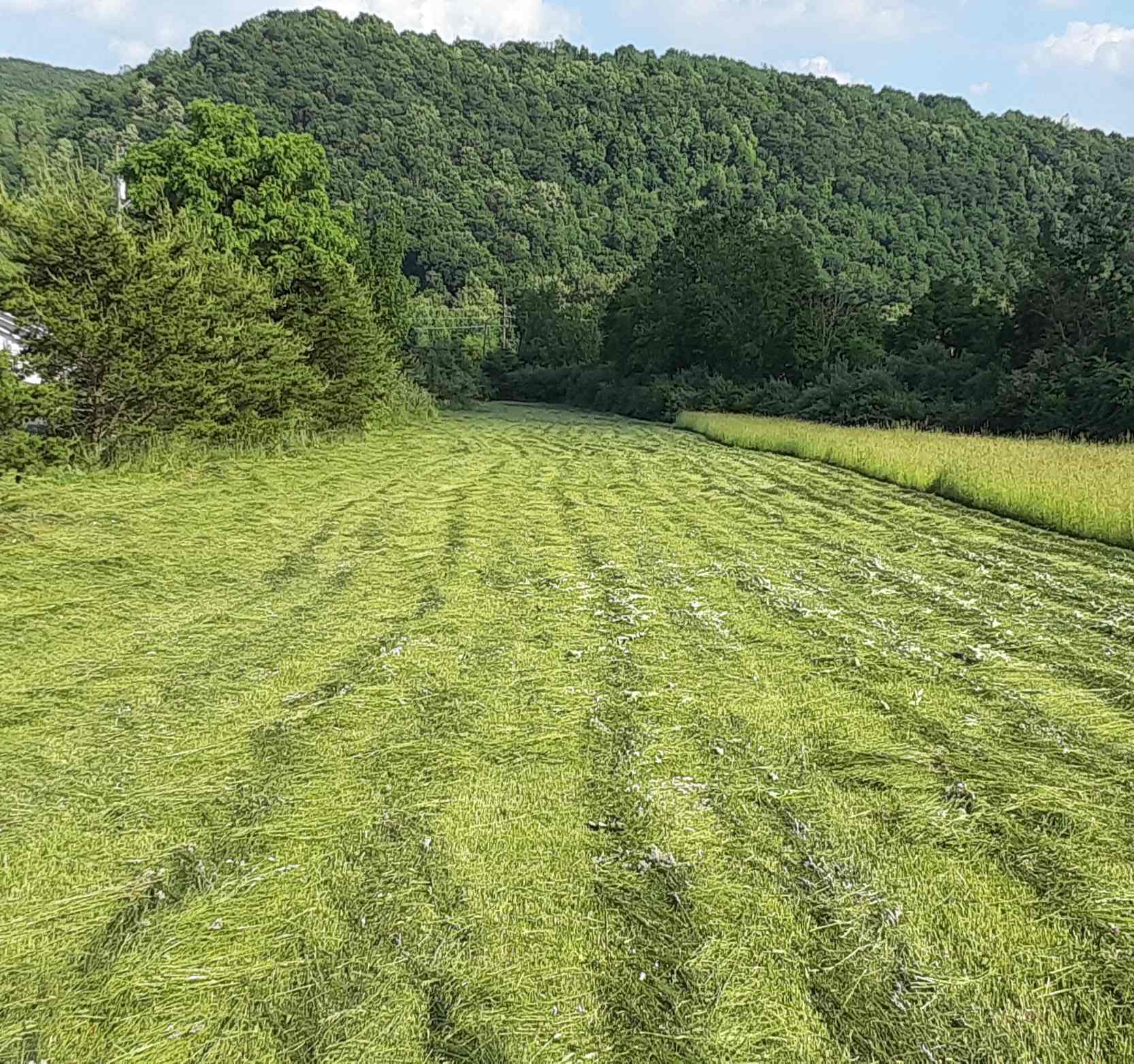
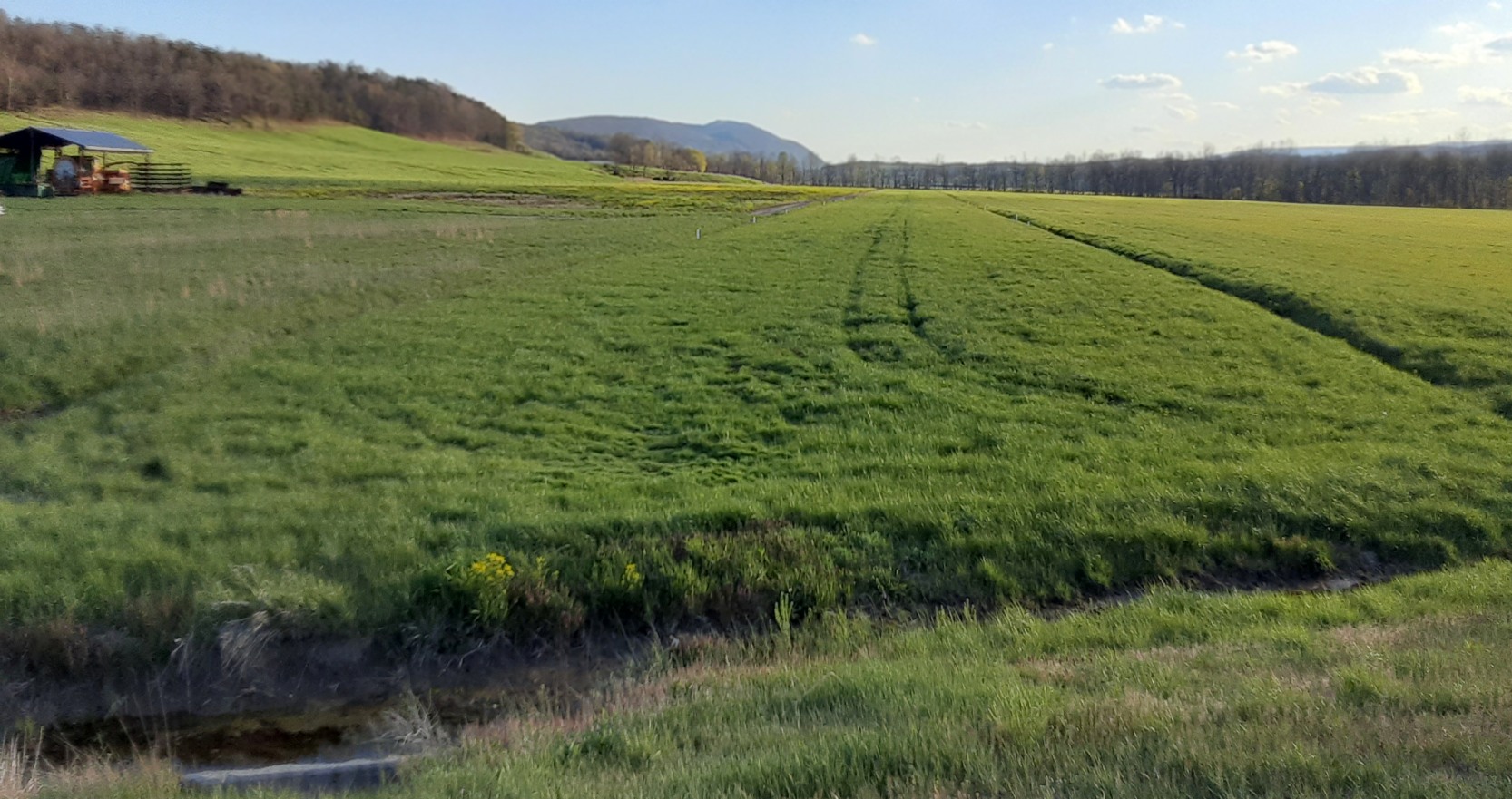
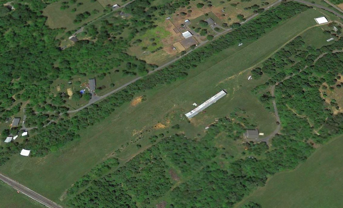
A 2015 photo by Rick Harshbarger looking northwest from the midpoint of the Thomas Airfield runway.
Rick reported, “It wasn't as easy to find as I thought, but with the help of a worker at the Thomas town hall, I eventually found it.
It's in MUCH better shape than I thought it would be. There are no aircraft there, but the runway is in very good shape.
I guesstimate the strip to be 2,750' x 80'. It appears to be rolled & mowed.
They've extended it to the southeast [compared to the 2013 aerial] picture - definitely longer in that direction now.
I think it is used a little [by aircraft] judging by tire marks in grass I could pick up. This strip took a lot of work to build.”
Rick also observed a “Runway drag for smoothing [the] runway”, and an “Old DoH road grader obviously used to work [the] runway.
This strip was cut out of a pine thicket. I can't imagine how many stumps had to be removed.”
Note the 2 windmills directly along the runway extended centerline, though.
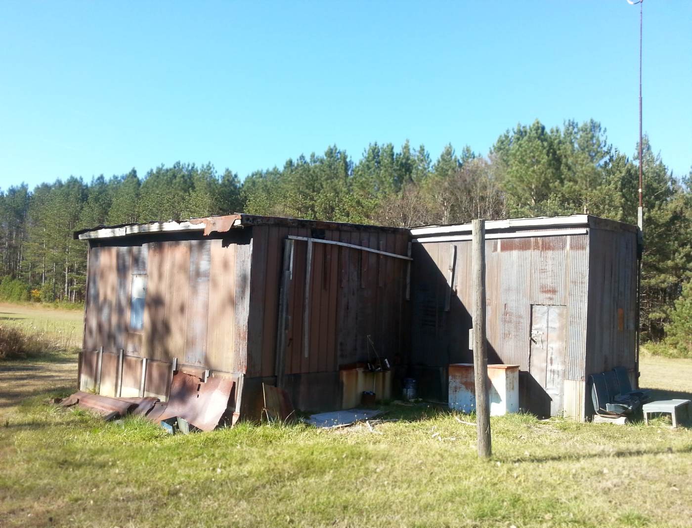
A 2015 photo by Rick Harshbarger looking northwest at the former T-hangar at Thomas Airfield. Rick reported, there are “No aircraft stored within.”
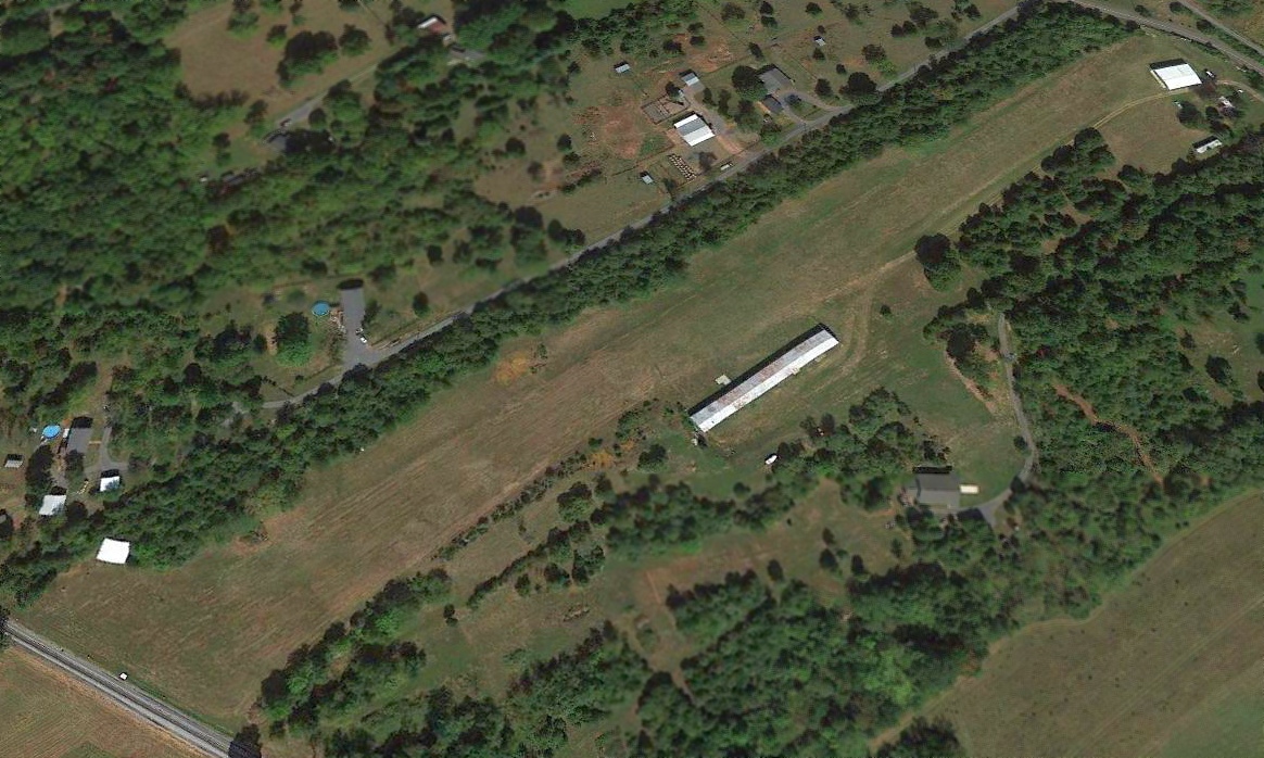
A 2020 aerial view looking north showed that someone has been keeping the Thomas Airfield runway cleared of growth, and the hangar remains intact as well.
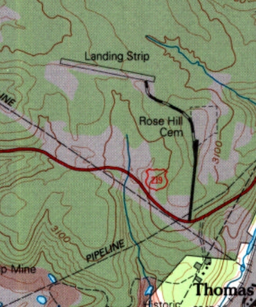
Thomas Airfield is located at the northern terminus of Airport Road, appropriately enough.
Thanks to Rick Harshbarger for pointing out this airfield.
____________________________________________________
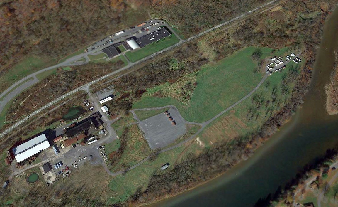
39.43, -78.99 (Northwest of Washington, DC)
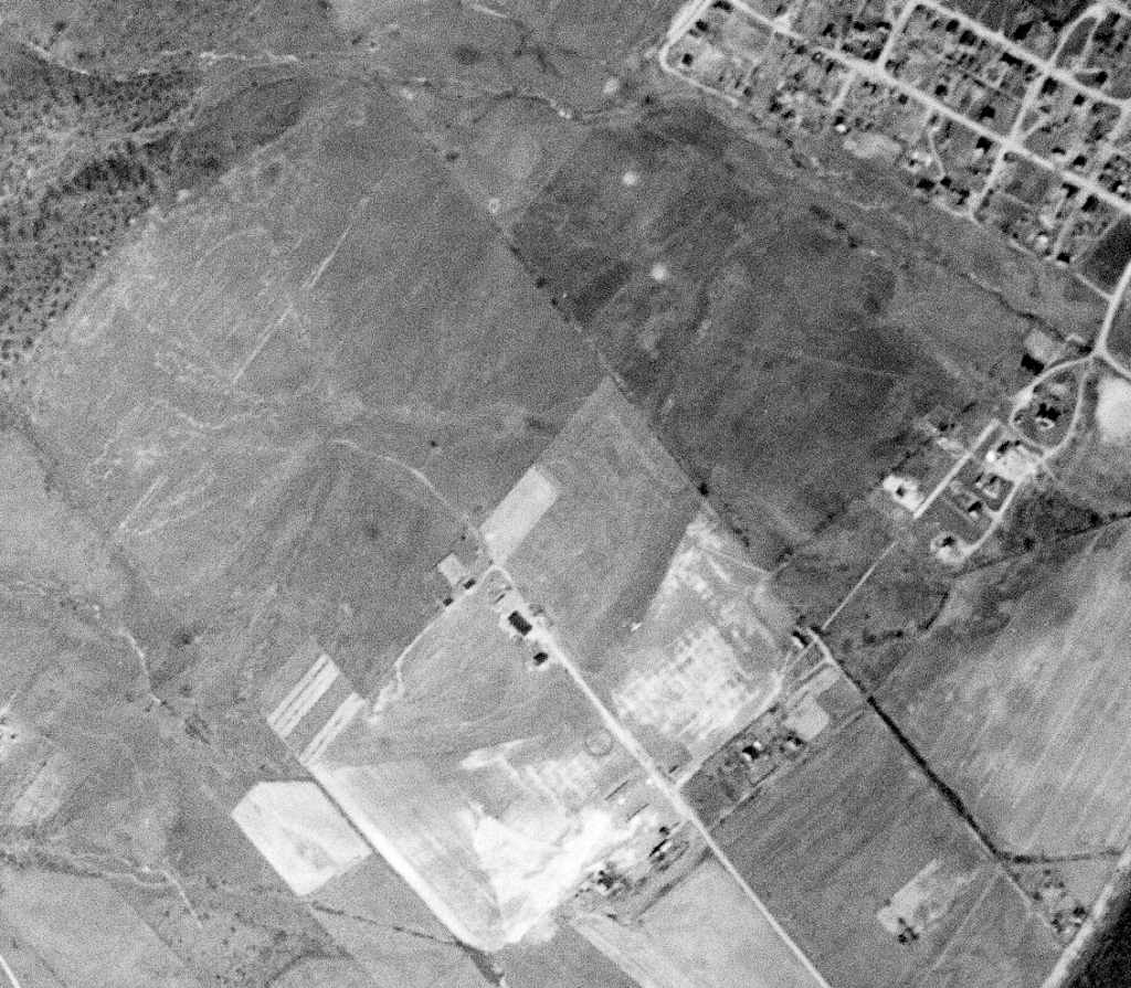
A 3/31/47 USGS aerial photo depicted one light-colored small aircraft in the middle of Keyser Airport.
Keyser Airport was not yet depicted on a 3/20/46 USGS aerial photo
nor on the October 1946 Huntington Sectional Chart (courtesy of Chris Kennedy),
According to Saundra Pancake (daughter of famous Keyser aviator Bill Pancake), “Keyser Airport was opened in 1946 by Arnold & Charles Ludwick who also owned Ludwick Chevrolet.”
The earliest depiction which has been located of Keyser Airport was on a 3/31/47 USGS aerial photo.
It depicted Keyser as an irregularly-shaped grass airfield, with an airport circle marking,
several small buildings (hangars?), and one light-colored small aircraft in the center of the photo.
According to Saundra Pancake, “On 10/14/47 an Army Air Force P-47 Thunderbolt made an off-airport unscheduled landing (crash) beside the [Keyser] airport runway & the pilot only had a broken nose.”
Broadus Bowman recalled, “It was called the Keyser Airport. One could take lessons there - they had a couple of J-3 Cubs.
A number of airplanes were tied down there, and I believe there were a few hangars.
It was located a couple miles south of Keyser on the west side of U.S. Route 220 - about a half-mile or mile off the road.
The runway ran sort of north/south, a grass runway.”
The earliest aeronautical chart depiction which has been located of Keyser Airport was on the 1948 Huntington Sectional Chart,
which depicted Keyser as having a mere 1,800' unpaved runway.
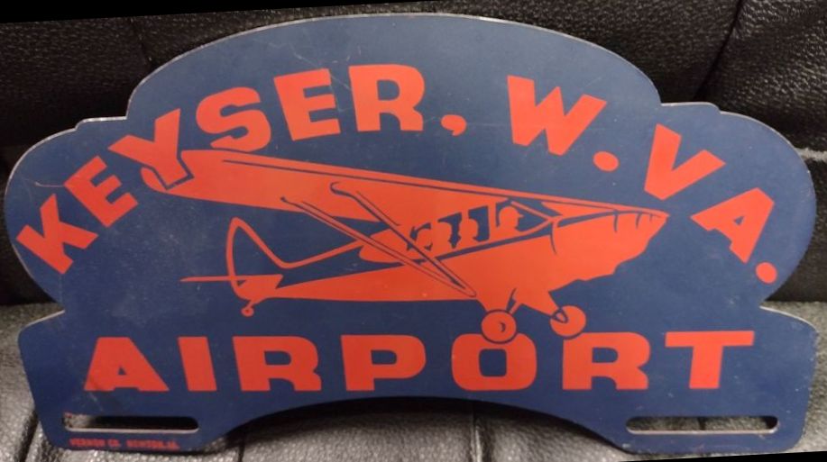
A circa 1950 license plate sign advertising Keyser Airport (from the Bill Pancake collection, courtesy of Rick Harshbarger).
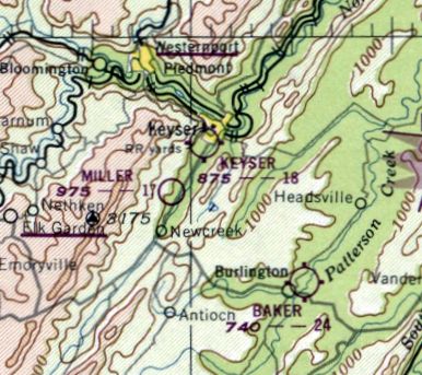
The 1951 USGS topo map depicted Keyser Airport as an irregularly-shaped outline, labeled simply as “Landing Field”,
with a few small buildings on the periphery.
According to Saundra Pancake, “Bill Pancake worked for Mr. Dantzic from 1953-56.”
According to Saundra Pancake, “The airport closed 6/1/56 & the operator of airport at that time was Stanley Dantzic.
Bill Pancake was the last person to fly off of the airport on October 1958.
Bill landed there to pick up his friend Jack Leatherman & they flew to the Burlington Airport.”
The last depiction which has been located of Keyser Airport was on the January 1960 Huntington Sectional Chart.
It depicted Keyser as having a 2,500' unpaved runway.
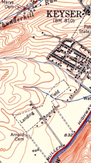
Keyser Airport, as depicted on the 1962 USGS topo map.
Keyser Airport was no longer depicted on the July 1962 Huntington Sectional Chart (courtesy of David Stevenson).
According to Rick Harshbarger, “My sister bought a house on a hill overlooking the former airport [in 1970]
and there were no planes there then & many of the houses in the 'Airport Addition' were already built.”
The 1972 USGS topo map continued to depict Keyser Airport as an irregularly-shaped outline, labeled simply as “Landing Field”.
The 1976 USGS topo map depicted streets & houses covering the site of Keyser Airport.
Rick Harshbarger reported in 2013, “The main hangar was used as a clothing factory for decades.”
Broadus Bowman reported in 2013, “Bill Pancake tells me when I drive up to the fire hall for the BHS Alumni Banquet I drove across the old runway!”
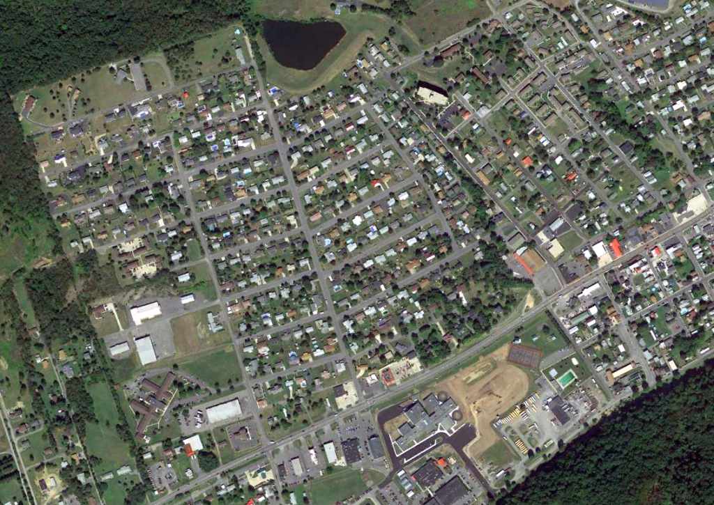
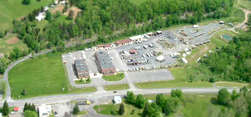
A 9/5/13 aerial photo showed houses covering the site of Keyser Airport.
However, according to Rick Harshbarger, the light-colored building at the bottom-left is the former main hangar.
According to Saundra Pancake, “The end of the runway was where Piney Valley is now.
The names of the streets in Airport Addition are aviation terms & names of the Ludwick family members.
Chandelle is the name of an aircraft maneuver. Beacon for the beacon navigation light. Terri was Arnold Ludwick's granddaughter.
Baker was named for Dave Baker who owned the Burlington airport.”
The site of Keyser Airport is located at the intersection of Beacon Street & Airport Street, appropriately enough.
____________________________________________________
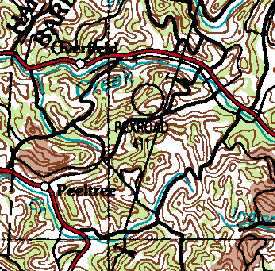
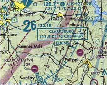
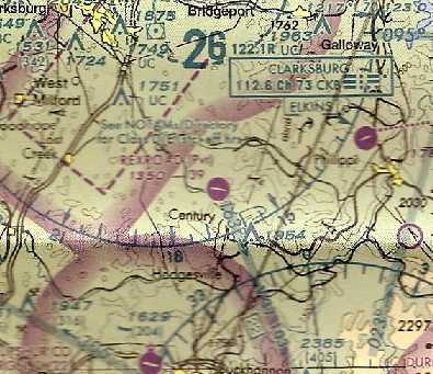
Rexroad Airfield (1st location), Peeltree, WV
39.16, -80.17 (Northwest of Washington, DC)
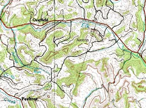
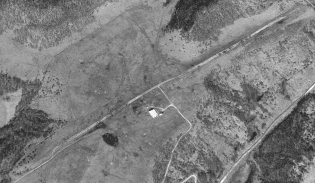
The 1981 USGS topo map depicted the 1st location of the Rexroad Airfield simply as “Airstrip”, but curiously did not depict a runway.
Photo of the airfield while in use has not been located.
This private airfield was evidently established at some point between 1977-81, as it was not yet depicted on the 1977 USGS topo map.
The earliest depiction of the Rexroad Airfield which has been located was on the 1981 USGS topo map.
Curiously, it labeled the site as “Airstrip”, but did not actually depict a runway.
The last depiction which has been located of the original Rexroad Airfield was on the 1988 USGS topo map.
At some point between 1988-97 the original location of the Rexroad Airfield was evidently replaced by a new location 2 miles to the southwest,
as the 1997 USGS aerial photo did not depict any trace of an airfield at the original location.
It appeared as if the original location had been replaced by strip mines.
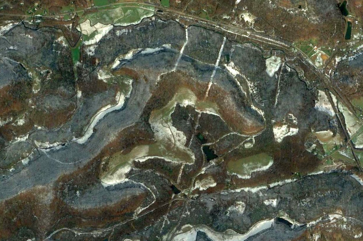
A 2013 aerial view did not show any recognizable trace remaining of the original Rexroad Airfield.
The site of the original Rexroad Airfield is located west of the intersection of Route 57 & Isaac S Run.
____________________________________________________
Rexroad Airfield (2nd location), Peeltree, WV
39.14, -80.21 (Northwest of Washington, DC)
A 1997 USGS aerial view looking northeast showed the 2nd location of the Rexroad Airfield as having a single east/west paved runway, with a checkerboard-roof hangar on the south side.
Photo of the airfield while in use has not been located.
Nothing was depicted at this location on a 1957 aerial view.
At some point between 1957-82 the original location of the Rexroad Airfield (2 miles northeast) was evidently replaced by a new location.
The earliest depiction which has been located of the 2nd site of the Redroad Airfield was a 1982 aerial photo.
It depicted Rexroad as having a single east/west paved runway, with a checkerboard-roof hangar on the south side.
The earliest depiction which is available of the 2nd site of the Redroad Airfield was a 1997 USGS aerial photo.
It depicted Rexroad as having a single east/west paved runway, with a checkerboard-roof hangar on the south side.
The earliest aeronautical chart depiction which has been located of the Rexroad Airfield was on the July 2001 Cincinnati Sectional Chart (courtesy of Rick Harshbarger).
It depicted Rexroad as a private airfield having a single east/west 3,900' paved runway.
A 2003 aerial view did not show any markings on the Rexroad Airfield runway.
The last aeronautical chart depiction which has been located of the Rexroad Airfield was on the July 2004 Cincinnati Sectional Chart.
It depicted Rexroad as a private airfield having a single east/west 3,900' paved runway.
The Rexroad Airfield was evidently closed (for reasons unknown) at some point between 2004-2007,
as an August 2007 aerial view showed the runway marked with a closed “X” symbol at each end.
The Rexroad Airfield was depicted as an abandoned airfield on the July 2008 Cincinnati Sectional Chart.
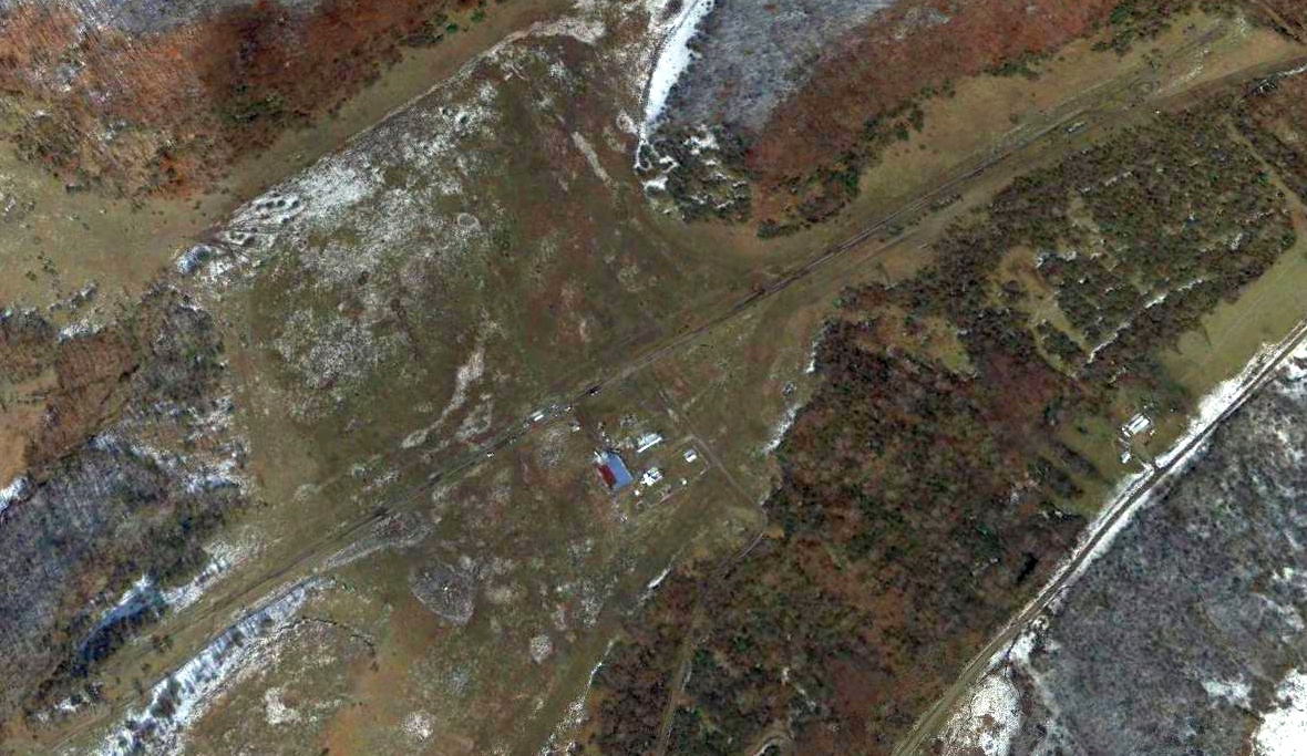
A 2013 aerial view looking northeast showed the Rexroad Airfield's runway & hangar remained intact, though deteriorated.
Nothing was depicted at the site of the Rexroad Airfield on the 2014 USGS topo map.
The 2017 USGS topo map depicted the Redroad Airfield's east/west runway as a runway, but unlabeled.
The site of the 2nd location of Rexroad Airfield is located north of the intersection of Route 20 & Arnolds Run.
____________________________________________________
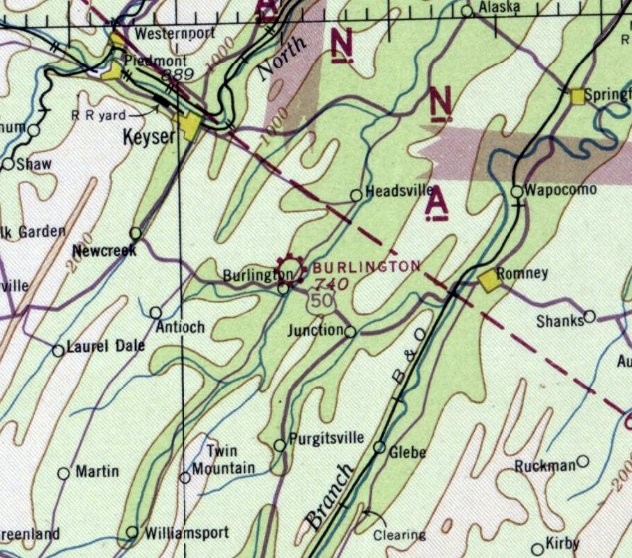
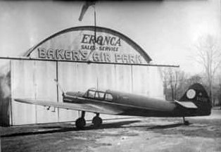
Burlington Airport / Baker Air Park, Burlington, WV
39.34, -78.91 (Northwest of Washington, DC)
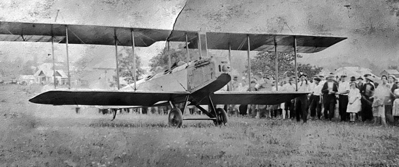
A circa 1930s photo of the first plane to land at the Burlington Airport, an unidentified biplane piloted by Herb Wentz (courtesy of Rick Harshbarger).
The date of establishment of the Burlington Airport has not been determined.
According to Bo Bowman, “The Burlington Airport probably opened in the late 1930s.
The owner was Dave Baker. Also had Baker's Drive-in Theater & Baker's Snack Bar restaurant across the highway.”
The earliest depiction of the Burlington Airport which has been located was a circa 1930s photo of the first plane to land there,
an unidentified biplane piloted by Herb Wentz (courtesy of Rick Harshbarger).
Robert Mitchell recalled, “From 1938-42 we were at Keyser & I remember seeing my very first airplane at the Burlington Airport.
It was a bright yellow Piper Cub.
The airport was sod & was located on the north side of US 50 just beyond an old hotel that had a pet deer.”
Burlington Airport was not yet depicted on the June 1942 Huntington Sectional Chart.
The earliest aeronautical chart depiction of the Burlington Airport which has been located was on the November 1942 Huntington Sectional Chart.
The April 1944 US Army/Navy Directory of Airfields (courtesy of Ken Mercer)
described Burlington Airport as having a 2,000' unpaved runway.
A circa 1943-45 aerial view looking north from the 1945 AAF Airfield Directory (courtesy of Scott Murdock)
depicted Burlington Airport as having a single northeast/southwest grass runway.
A single light plane was visible at the southwest corner.
The 1945 AAF Airfield Directory (courtesy of Scott Murdock) described Burlington Airport
as a 30 acre irregularly-shaped property within which were 2 sod runways, measuring 1,850' ENE/WSW & 1,000' NNE/SSW.
The field was said to have a single 46' x 40' metal & wood hangar,
and to be privately owned & operated.
According to Bo Bowman, “A 1945 Airport Directory described it as having a sod east/west 2,200’ x 500’ runway.
One interesting fact recalled is that a German Messerschmidt from WWII
was obtained & shipped to this airport by a local Army Air Corps man.
The plane was restored, painted a bright red,
and was sometimes flown on weekends for the local airport spectators’ enjoyment.”
A circa 1946/47 photo by Chris Caldwell (courtesy of Rick Harshbarger) of Alvin (Junior) Thrush & his Aeronca at Burlington Airport.
A 1947 aerial photo showed Burlington Airport as having a single east/west grass runway,
with 2 or 3 light planes parked near a few small buildings on the southwest side.
At some point between 1944-54 the official name of the airport had changed to “Baker”, that is how it was labeled on the 1948 Huntington Sectional Chart.
It depicted Baker as having a 2,400' unpaved runway.
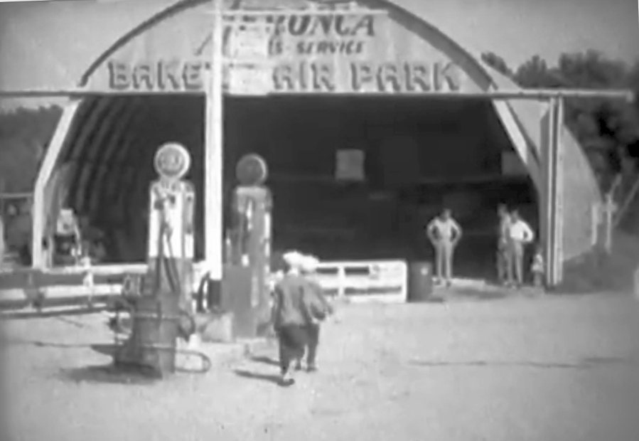
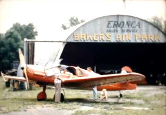
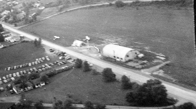
A still image of the “Baker Air Park” hangar from a 16mm film taken on 9/11/49 (courtesy of Bo Boman).
The boy with the sailor hat in the foreground is Bo Bowman, with his younger cousin Paul leading him to the hangar.
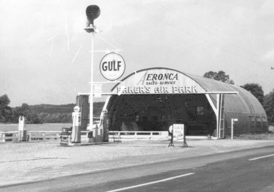
A circa 1940s picture of the same Baker's Air Park hangar (courtesy of Rick Harshbarger).
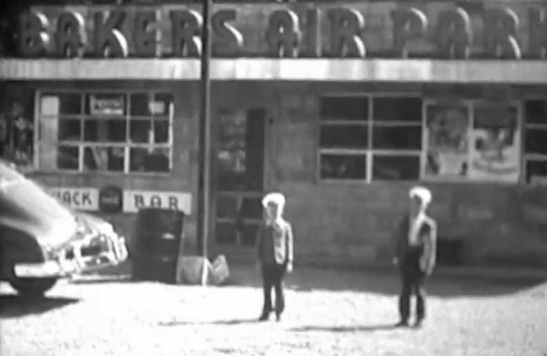
A still image of Bo Bowman & his cousin Paul in front of the “Bakers Air Park” snackbar from a 16mm film taken on 9/11/49 (courtesy of Rick Harshbarger).
According to Rick, “It was quite a lively place according my Dad whose hunting camp was just over the ridge from the airfield, especially on the weekends.”
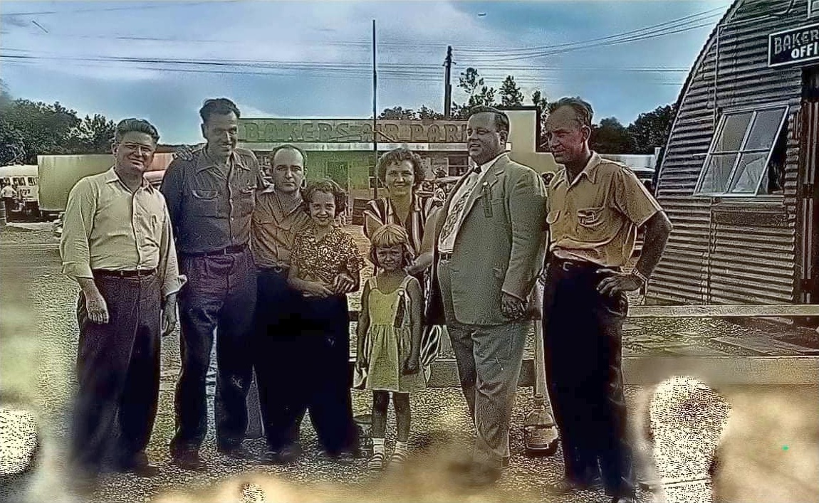
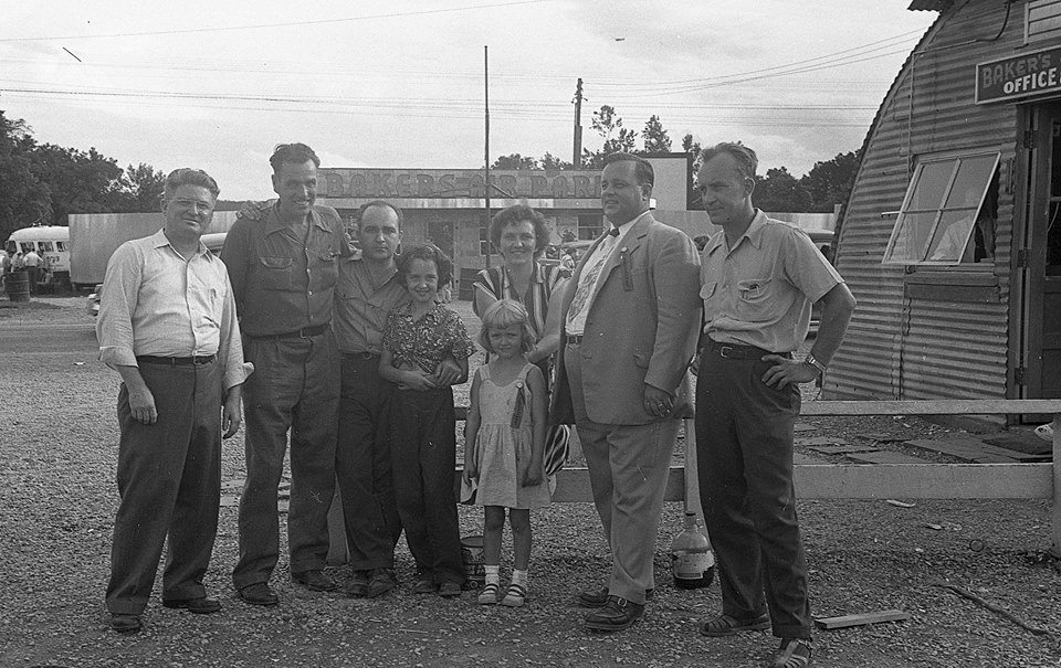
A circa 1940s/50s photo of Dave Baker & others in front of the “Bakers Air Park” snackbar (courtesy of Rick Harshbarger).
According to Bo Bowman, “This airport was a typical small-town country airport, offering passenger rides primarily on weekends.
The aircraft used for this purpose in the late 1940s were 2 Aeronca Champs.
The airport was owned & operated by David Baker.
This is where flying began for me at the age of about 8. I have lots of memories from there.
Dave Baker took me for my first airplane ride in an Aeronca Champ - both my Mother & I in one seat.”
According to Wings Over Cumberland by Bob Polling & Bill Armstrong (courtesy of Rick Harshbarger),
“By 1953, there was no longer much flight training at the air park.
A.V. 'Junior' Thrush had obtained his mechanic’s license under the GI Training Bill, and he began to take over the maintenance at Baker’s Air Park.
Dave obtained a contract to fly for the WV Department of Agriculture, doing forest survey work.
This involved low-altitude flying with an observer, while looking for diseased trees.
Flying a Cessna 140, they were working an area on the east side of the Knobley Mountains on a very windy day.
Getting into severe turbulence & downdrafts, they ended up in the trees, demolishing the aircraft.
Dave was quite badly injured. He recuperated, but this accident signaled the end of Dave’s flying career.”
The 1954 Huntington Sectional Chart (courtesy of Chris Kennedy) depicted Baker as having a 2,400' unpaved runway.
A still image from a Summer 1956 movie of the pretty red Messerschmidt Bf 108 Taifun in front of the “Baker's Air Park” hangar (courtesy of Rick Harshbarger).
According to Rick Harshbarger, “My Dad knew the guy with the Messerschmidt. They were both WW2 veterans.
He said he sent it back from Germany in pieces & reassembled it at Burlington.”
Note that the first letter of the “Aeronca” painted on the hangar had been removed, oddly.
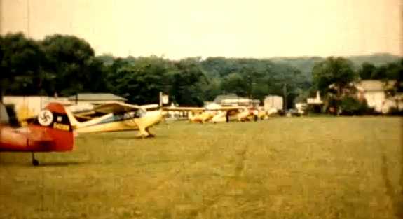
A still image from a Summer 1956 movie of the Messerschmidt Bf 108 Taifun & 5 other single-engine planes at Baker's Air Park (courtesy of Rick Harshbarger).
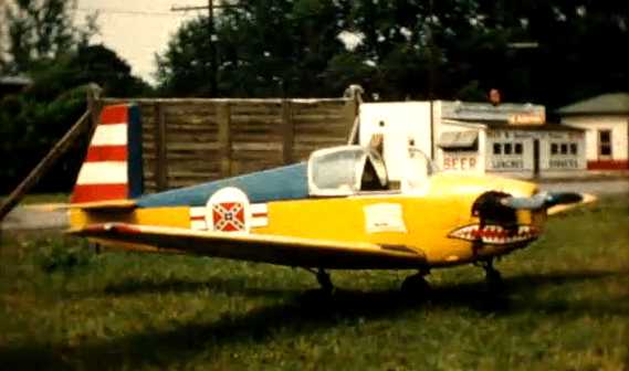
A still image from a Summer 1956 movie of a fancifully-painted Mooney Mite of the Confederate Air Force at Baker's Air Park (courtesy of Rick Harshbarger).
A circa 1950s photo of the red Messerschmidt Bf 108 Taifun in front of the “Baker's Air Park” hangar (courtesy of Rick Harshbarger).
The 1956 USGS topo map depicted it as “Bakers Airpark”.
A circa 1950s aerial view looking northwest at Baker Air Park (courtesy of Rick Harshbarger),
showing 2 light single-engine taildraggers parked near the hangar & smaller building.
A circa 1950s photo of the Baker family at Baker Air Park (courtesy of Rick Harshbarger).
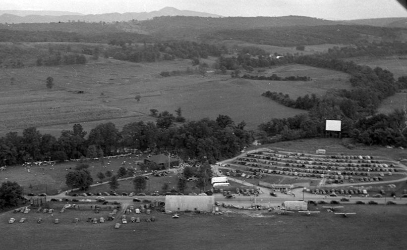
A circa late 1950s – early 1960s aerial view looking south at Baker Air Park (courtesy of Rick Harshbarger).
Rick remarked, “It's on the day of the annual 'Mill Picnic' held by the big paper mill in nearby Luke MD, Westvaco Corp.
You can see a huge crowd gathered for food, fun, games, plane rides, and that night, a free movie at the Baker Drive-in across US Route 50 from the airfield.
I remember going to these as a child as my Dad retired from that mill with 44 years of service. It seemed to me that everyone's Dad worked at 'The Mill'.”
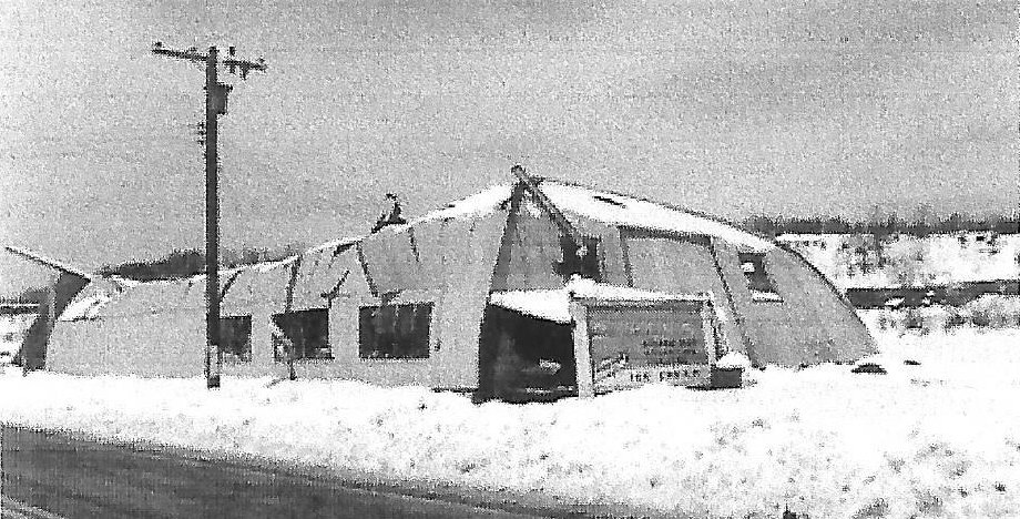
An undated photo of the Baker Air Park hangar, which had collapsed after a heavy snow in February 1962.
According to Wings Over Cumberland by Bob Polling & Bill Armstrong (courtesy of Rick Harshbarger),
“In February 1962, the hangar roof collapsed under an accumulation of heavy, wet snow.
Junior then moved his maintenance operation to a new building near his home.
Although the field remained usable for several years, no further operations were conducted there.”
The last aeronautical chart depiction which has been located of Baker Airpark was on the February 1969 Huntington Sectional Chart.
It depicted Baker as having a 2,400' unpaved runway.
According to Bo Bowman, “The Burlington Airport probably closed in the late 1960s.”
Baker Airpark was no longer depicted at all on the 1969 USGS topo map.
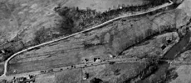
The Baker Airpark hangar was still standing in a 1971 aerial photo, and the airfield was still clear,
but there were no aircraft visible on the field.
By the time of the 1972 USGS topo map, the Baker Air Park was no longer depicted at all,
but another (unrelated?) airfield was depicted just to the southeast on the opposite side of Route 50.
An early 1980s photo by Terrie Rogers “of the Burlington Airpark snack bar which doubled as a snack bar for Baker's drive in movie theater” (courtesy of Rick Harshbarger).
According to Wings Over Cumberland by Bob Polling & Bill Armstrong (courtesy of Rick Harshbarger),
“The site was eventually sold to the state of West Virginia.”
A 1989 aerial photo showed 2 Department of Transportation buildings had been constructed on the site of Baker Airpark.
A June 2006 aerial photo by Bo Bowman looking north at the site of Baker Air Park.
According to Bo Bowman, “It was located parallel to & on the north side of Route 50,
bounded on the other side by the tree-lined road.”
The former airport property appears to have been reused as a highway department facility.
No trace appears to remain of the former airport.
The site of the former Baker Air Park is located on the north side of Route 50, east of its intersection with Route 11.
____________________________________________________
Dawson Army Airfield (1st location), Kingwood, WV
39.45, -79.67 (South of Pittsburgh, PA)
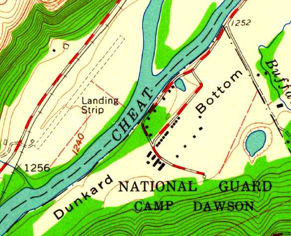
The original Dawson Army Airfield was depicted as an unpaved “Landing Strip”
on the northwest bank of the Cheat River on the 1960 USGS topo map.
Camp Dawson was established in 1909, when the WV State Legislature
authorized the purchase of 196 acres of land on Dunkard Bottom along the Cheat River in Preston County.
The camp was named in honor of William M. O. Dawson, a native of Preston County, who served as Governor from 1905-08.
Troops began training at Camp Dawson during the summer of 1909 and continued until the start of Word War I.
The camp was not used again until 1928 when it was reestablished as a training site for the West Virginia State Militia.
Units trained regularly at the camp until the outbreak of World War II
at which time the United States Government leased the camp for use as a Prisoner of War camp.
No airfield at Camp Dawson was yet depicted on the 1942 USGS topo map.
The original airfield for Camp Dawson was located on the northwest bank of the Cheat River.
The earliest reference to the Camp Dawson airfield came from Robert Mitchell,
who recalled, “In 1954-58 I was attached to the 249th Army Band WVNG in Fairmont.
We were attached to the local artillery unit for administrative purposes
and several times during those years we went up to Camp Dawson for rifle qualifications.
I do remember there being a small field there.
As I remember it, Dawson was a beautiful little camp.”
The earliest depiction of the Dawson airfield which has been located was a 1956 aerial photo.
It depicted a single unpaved northeast/southwest runway.
The earliest depiction of the Dawson airfield which is available was on the 1960 USGS topo map,
which depicted a single 2,500' unpaved runway, labeled simply as “Landing Strip”, with one small building on the southwest side.
However, no airfield at Dawson was depicted on the 1960 or 1967 Huntington Sectional Charts (according to Chris Kennedy),
or the February 1970 Cincinnati Sectional Chart (according to Chris Kennedy).
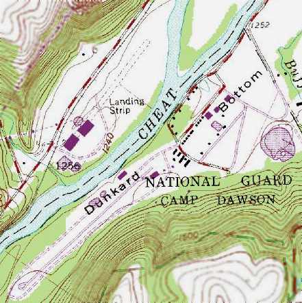
The 1976 USGS topo map still depicted the “Landing Strip”,
however the map also depicted 2 buildings superimposed over the southwest end of the runway.
At some point between 1970-76, the original Dawson AAF
was evidently replaced by a new airfield on the opposite side of the river,
as only the field on the southeast side of the river was depicted
on the August 1976 Cincinnati Cincinnati Sectional Chart (courtesy of Chris Kennedy).
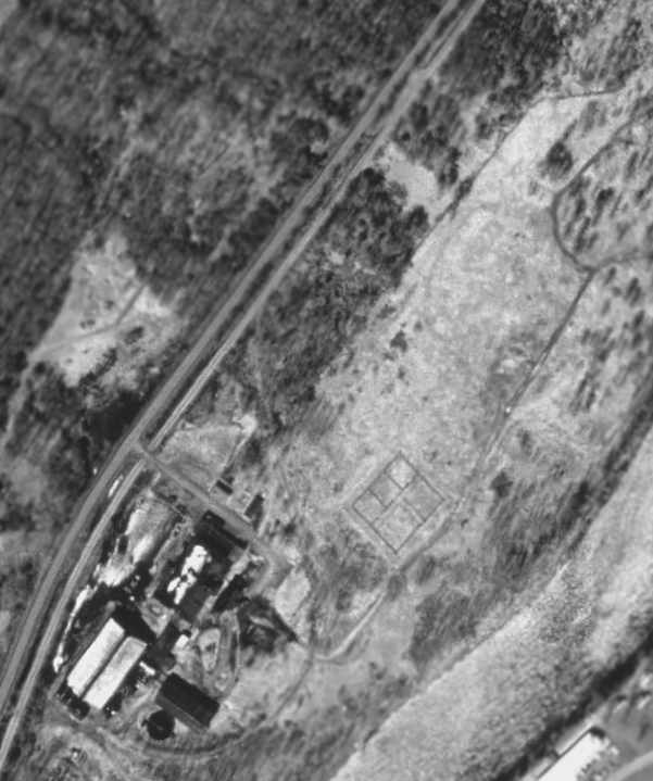
As seen in the 1997 USGS aerial photo, only the slightest trace is still recognizable of the outline of the runway of the original Dawson AAF.
A 2016 aerial view looking northwest showed no trace still recognizable of the original Dawson AAF.
The original Dawson AAF is located in between Route 72 & the Cheat River.
____________________________________________________
Or if you prefer to contact me directly concerning a contribution (for a mailing address to send a check),
please contact me at: paulandterryfreeman@gmail.com
If you enjoy this web site, please support it with a financial contribution.
____________________________________________________
This site covers airfields in all 50 states.