Abandoned & Little-Known Airfields:
Southwestern Washington State
© 2002, © 2025 by Paul Freeman. Revised 11/10/25.
This site covers airfields in all 50 states: Click here for the site's main menu.
____________________________________________________
Please consider a financial contribution to support the continued growth & operation of this site.
Cougar Flat Airstrip (added 6/16/22) - Elma Municipal Airport (revised 3/10/25) - Evergreen Field / Suggs Airport (revised 11/10/25)
Hewitt Field (revised 1/31/25) - Longview Airport / Taylor Airport (revised 10/23/20) - Ocean Park Skyport (added 7/31/22)
Ocean Shores Airport / Corning Field (revised 1/31/25) - Scholl's Airport / Clark County Airport (revised 11/10/25)
____________________________________________________
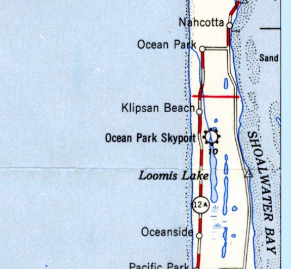
Ocean Park Skyport, Klipsan Beach, WA
46.457, -124.052 (Southwest of Seattle, WA)
Ocean Park Skyport, as depicted on a 1949 USGS topo map.
Photo of the airfield while in use has not been located.
This small airfield was evidently established at some point between 1938-49,
as it was not yet depicted on the 1938 USGS topo map.
The earliest depiction which has been located of Ocean Park Skyport was on a 1949 USGS topo map.
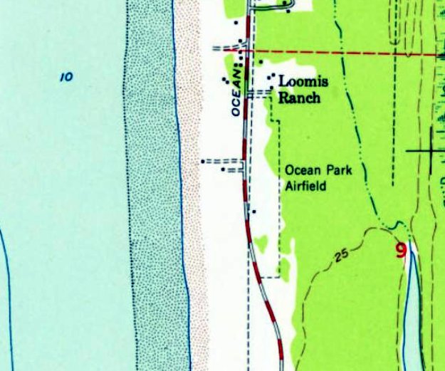
Another 1949 USGS topo map depicted “Ocean Park Airfield” as a north/south rectangular property outline, with a single small building on the west side.
The Ocean Park Airfield was not depicted at all on 1960s/70s/90s Sectional Charts.
The earliest photo which has been located of the Ocean Park Airfield was a 1981 aerial view, which depicted the runway as remaining clear.
John Sargent reported, “I tried to get permission to use the airfield in the early 1980s, but was denied.”
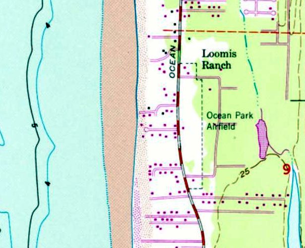
The 1984 USGS topo map continued to depict “Ocean Park Airfield” as a north/south rectangular property outline, with a single small building on the west side.
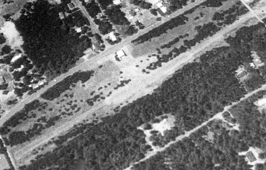
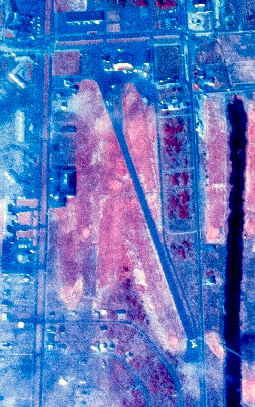
The earliest photo which is available of the Ocean Park Airfield was a 1996 aerial view looking northwest, which showed the runway as overgrown but intact.
A 2006 aerial view depicted several buildings had been built over the northern portion of the Ocean Park Airfield at some point between 1996-2006.
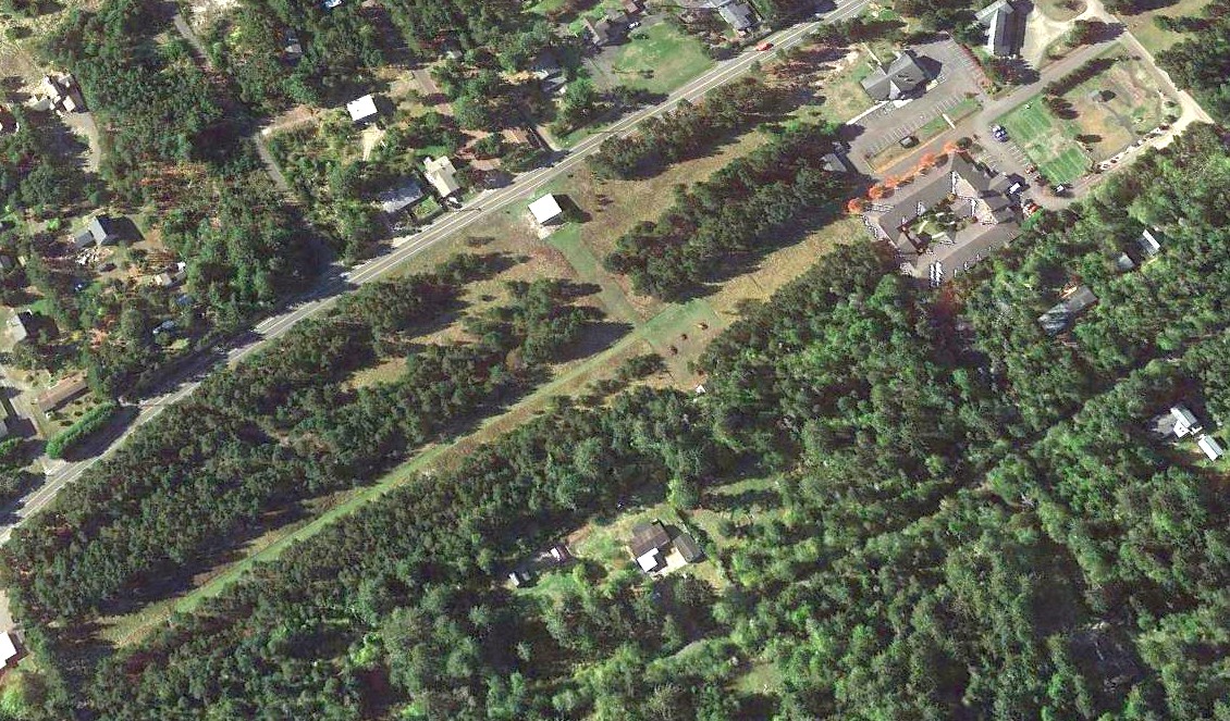
A 2018 aerial view looking northwest showed the majority of the Ocean Park Airfield runway remained recognizable, and the hangar remained on the west side.
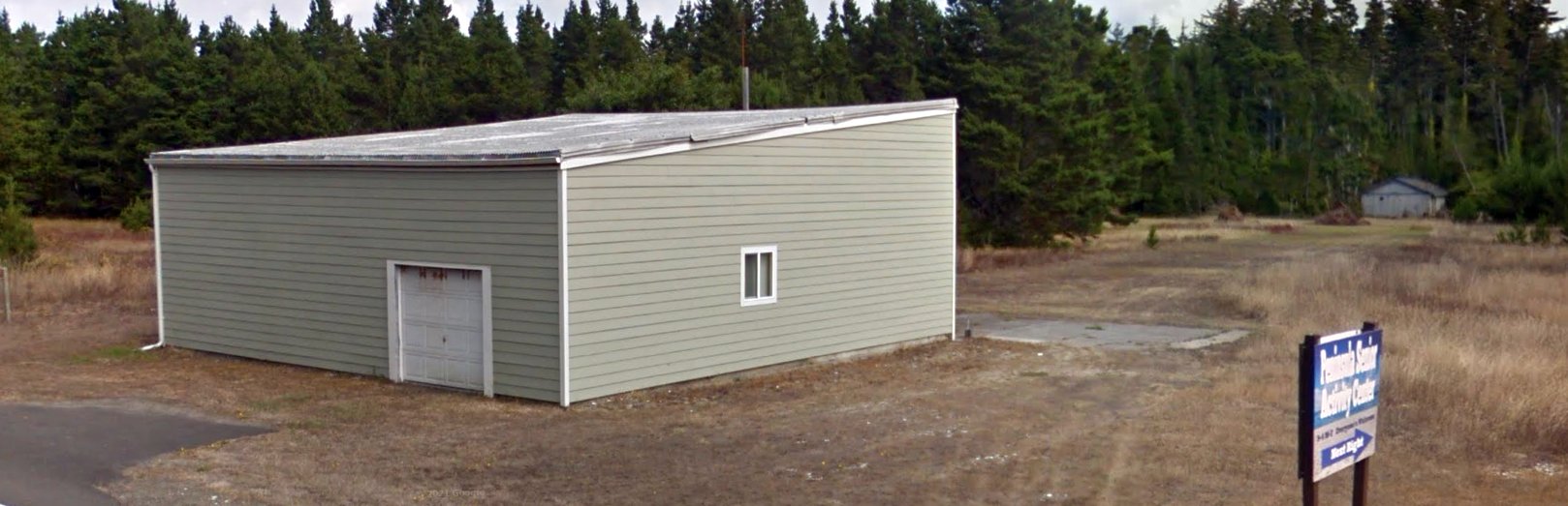
An August 2018 photo looking northeast showed the former hangar on the west side of the Ocean Park Airfield, along with another building on the east side.
John Sargent reported in 2022, “A hangar can be seen adjacent to Highway 103. It had a Cessna 180 in it belonging to a car dealer named Loren Corder.
I understand a Labor Day Car Show is held on the old airstrip every year.
Thanks to John Sargent for pointing out this airfield.
____________________________________________________
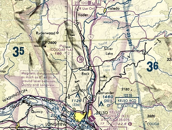
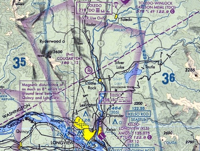
Cougar Flat Airstrip (WN24), Cougar Flat, WA
46.296, -122.952 (South of Seattle, WA)
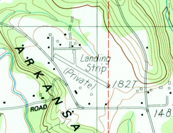
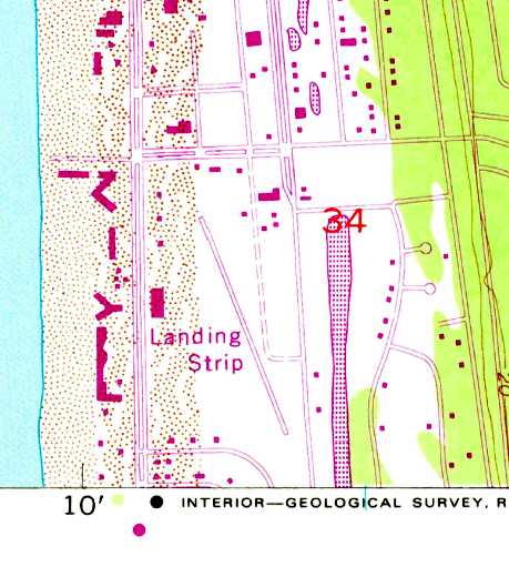
Cougar Flat Airstrip, as depicted on the 1984 USGS topo map (courtesy of Lee Corbin).
This small private airfield was evidently established at some point between 1970-81, as it was not yet depicted on a 1970 aerial photo.
The earliest depiction which has been located of Cougar Flat Airstrip was a 1981 aerial view.
It depicted a single northwest/southeast unpaved runway, with a few small buildings on the north side.
There were no aircraft visible on the field.
The earliest topo map depiction which is available of Cougar Flat Airstrip was on the 1984 USGS topo map (courtesy of Lee Corbin),
which depicted a single northwest/southeast runway, labeled generically as “Landing Strip (Private)”.
According to its FAA Airport/Facility Directory data, Cougar Flat Airstrip had a single 1,214' turf Runway 9/27 (which is a different runway orientation than all of the depictions).
The earliest photo which is available of Cougar Flat Airstrip was a 1990 USGS aerial view (courtesy of Lee Corbin).
It depicted a single northwest/southeast unpaved runway, with a few small buildings on the north side.
Two light single-engine aircraft were parked on the taxiway on the north side of the runway.
The earliest aeronautical chart depiction which has been located of Cougar Flat Airstrip was on the January 1994 Seattle Sectional Chart.
It depicted Cougar Flat Airstrip as a private airfield having a mere 1,200' unpaved runway.
The last aeronautical chart depiction which has been located of Cougar Flat Airstrip was on the June 1999 Seattle Sectional Chart.
It depicted Cougar Flat Airstrip as a private airfield having a mere 1,200' unpaved runway.
Cougar Flat Airstrip was evidently closed (for reasons unknown) at some point between 1999-2006,
as a 2006 aerial photo showed the aircraft gone, and the runway deteriorated.
A 2009 aerial photo showed houses having been built over Cougar Flat Airstrip at some point between 2006-2009.
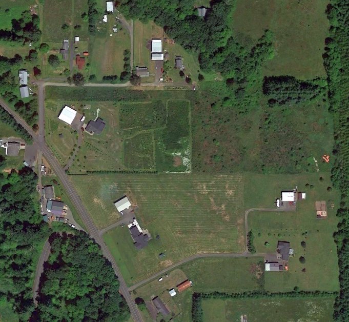
A 2021 aerial view showed houses covering the Cougar Flat Airstrip runway, of which only the faintest traces remained of the middle portion.
Thanks to Lee Corbin for pointing out this airfield.
____________________________________________________
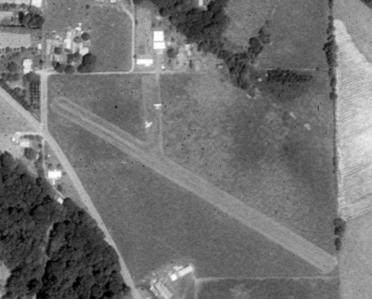
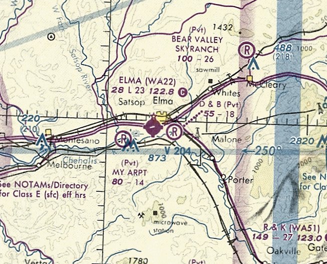
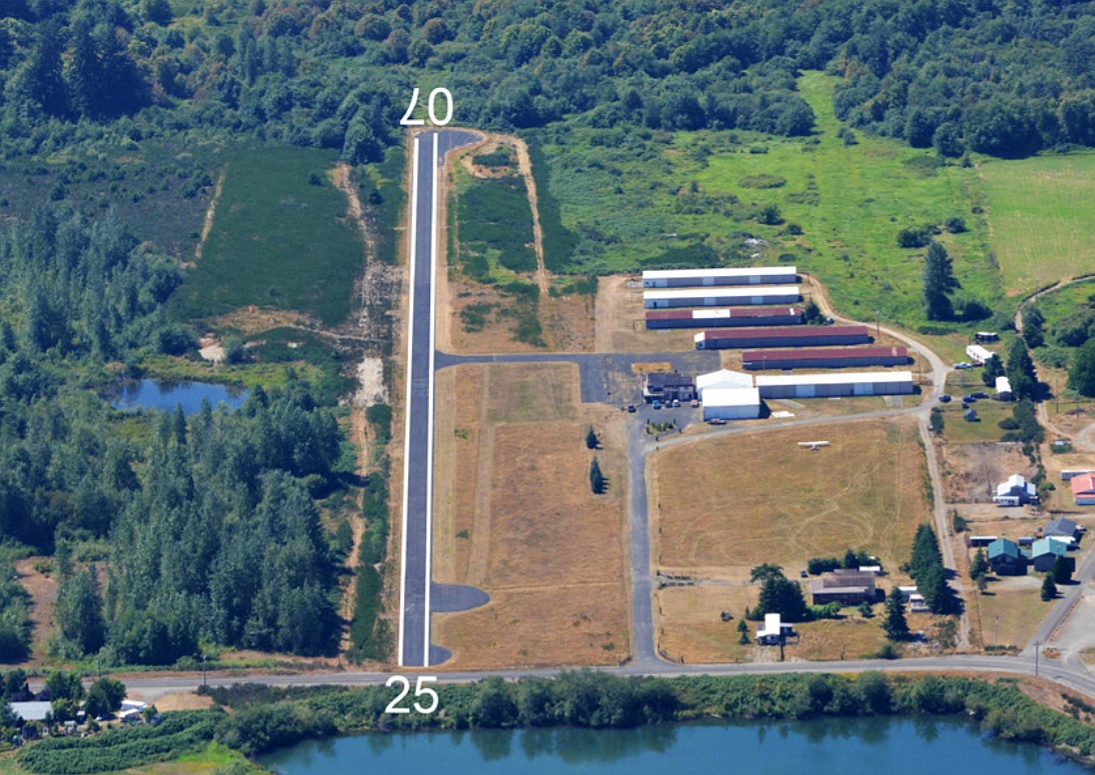
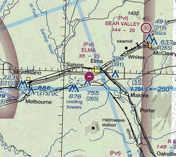
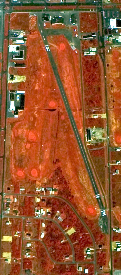
Elma Municipal Airport (4W8, 1WA7), Elma, WA
46.991,-123.43 (Southwest of Seattle, WA)
Elma Municipal Airport was labeled generically as “Landing Strip” on the 1986 USGS topo map.
Elma Municipal Airport was not yet depicted on the 1962 USGS topo map.
According to its FAA Airport/Facility Directory data, Elma Municipal Airport was established in December 1974.
John Prukop recalled, “I was the one who put the Elma Airport ON the Seattle Sectional Chart.
I worked closely with Mac McIver & Bill Hamilton at the Washington State Aeronautics Commission & FAA planners to secure a Planning Grant Program for the Environmental Study, etc.
to secure grant monies from the State of WA & the FAA for the the Airport Master Plan & the Paving & Lighting project which came along in about 1974-75.
A rotating beacon & lighted windsock were included, along with MIRL runway lights.
I served as the 'gratis' airport manager & ran Timberland Skyways, Inc., a small FBO & Texaco AvGas facility.
We had all the hangars full, over 20 students enrolled in our FAA Part 141 Flight School for Private, etc. They were good times.”
The earliest depiction which has been located of Elma Municipal Airport was a 1981 aerial view.
It depicted Elma as having a single east/west paved runway, 5 hangars on the north side, and 10 light single-engine aircraft parked on the northeast side.
The earliest depiction which is available of Elma Municipal Airport was on the 1986 USGS topo map,
which depicted a single east/west paved runway, labeled generically as “Landing Strip”, and 6 small buildings on the north side.
Brian Reynolds recalled, “I flew in & out of this airport in the 1980s. It actually had a restaurant in the big square building.
It was once a vibrant little airport for the $100 burger pilots.”
The earliest aeronautical chart depiction which has been located of Elma Municipal Airport was on the January 1994 Seattle Sectional Chart (courtesy of Ron Plante).
It depicted Elma as a public-use airport having a single 2,300' paved northeast/southwest runway.
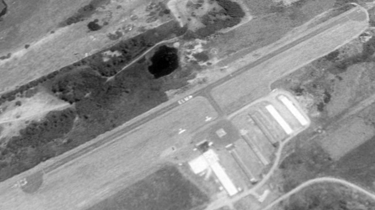
The earliest photo which is available of Elma Municipal Airport was a 1990 USGS aerial view looking southwest.
It depicted Elma as having a single asphalt Runway 7/25, 7 hangars on the north side, and 2 light single-engine aircraft parked on the northeast side.
An august 2013 photo looking west along Elma Municipal Airport's runway, showing 1 single-engine Cessna parked near the hangars.
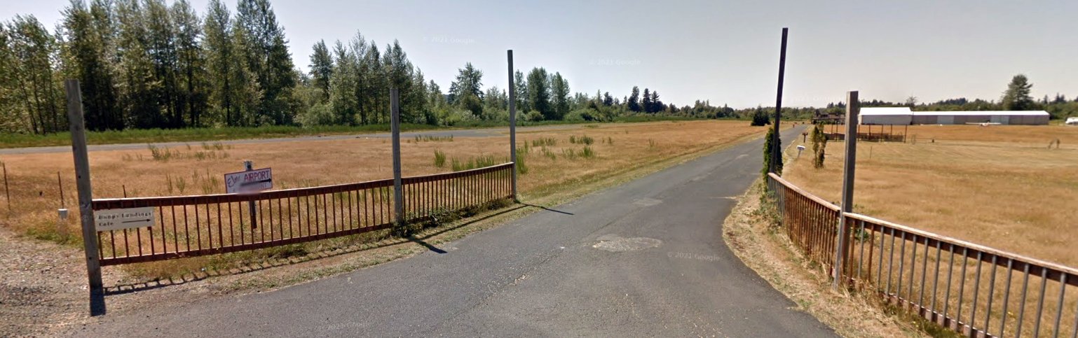
An august 2013 photo looking south at the Elma Municipal Airport entrance, showing a sign for the Happy Landings Cafe.
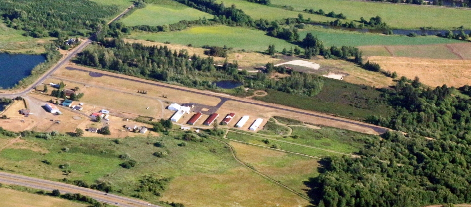
A 6/19/15 aerial view looking southeast pictured Elma Municipal Airport as having a paved east/west Runway 7/25 & 7 hangars on the north side of the field.
The only aircraft seen on the field was 1 single-engine Cessna parked in the grass on the northeast side, relatively far from the runway.
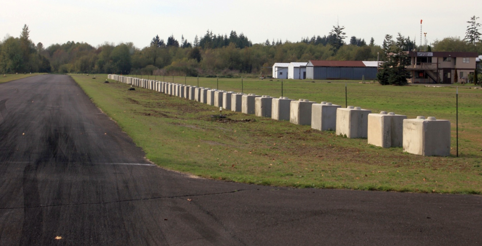
A 10/15/15 photo by Bob Bogash looking along the Elma Airport runway.
Bob reported, “The blocks were (I was told) to protect the race fans from wandering drag racers. The racers were on their own.
They also acted as good locomotive cow catcher devices for errant airplanes.”
Bob Bogash recalled, “Elma Airport had a great cafe & was one of the prime stops on the burger run trail.
I visited it several times on the ground & saw airplanes in hangars & airplanes flying in, but when I flew down I saw 'X's on the ends of the runways.
They looked very faded, like from a past construction project or some such, so I spent a whole year trying to find out its status.
I called the phone numbers listed with no results.
Then I went down a long daisy chain starting with Washington State Aviation Department, FAA airports division, City of Elma (it was listed as 'Elma Municipal'),
then Gray's Harbor County, Public Works Division; finally Washington State Patrol - whose Aviation Division flies around there & might fly in.
Nobody knew
anything. Someone thought the owner had died & the airport was in
a litigation over the probate.
Then one day, flying into
Shelton, which shared the CTAF frequency, I heard a guy in the
pattern in Elma.
So I flew down & landed. The cafe was in ruins, large concrete blocks lined a portion of the runway, and a bunch of questionable-looking guys were in a garage working on drag racers.
The strip was used for racing on weekends. They said the strip was going to be fixed up & the cafe re-opened, but never saw any later sign of it.
Checking my Logbook, I flew in there 10/15/15.
Then l learned from CLS Airport Manager via a 3rd party that airport was closed & the property was being used as a pot farm.”
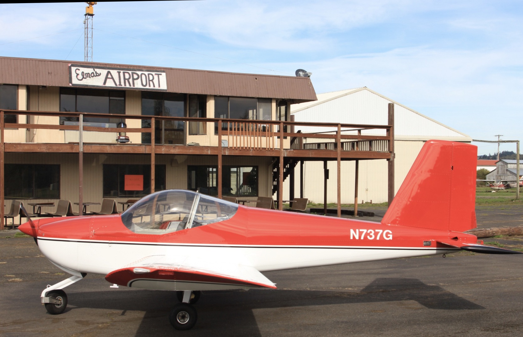
A 10/15/15 photo by Bob Bogash of his pretty Vans RV-12 in front of the Elma Airport cafe.
For the year 2017, the FAA Airport/Facility Directory described Elma Municipal Airport as conducting an average of 33 takeoffs or landings per day.
An undated aerial view looking west at Elma Municipal Airport from the 2020 WA Airport Directory.
It described Elma as having a 2,280' asphalt Runway 7/25, and pictured 7 hangars on the north side of the field.
Oddly, the only aircraft seen on the field was 1 single-engine Cessna parked in the grass (lower-right), relatively far from the runway.
As of 2020, the FAA Airport/Facility Directory described Elma Municipal Airport as a private use airport (contradictory for a “Municipal” airport),
owned by Deryck Tsang & managed by Colomba Tsang.
It was said to have a single 2,280' asphalt Runway 7/25, “in fair condition”,
and to have 28 single-engine aircraft based on the field.
The last aeronautical chart depiction which has been located of Elma Municipal Airport was on the 2020 Seattle Sectional Chart.
It depicted Elma as a private airfield having a single 2,300' paved east/west runway.
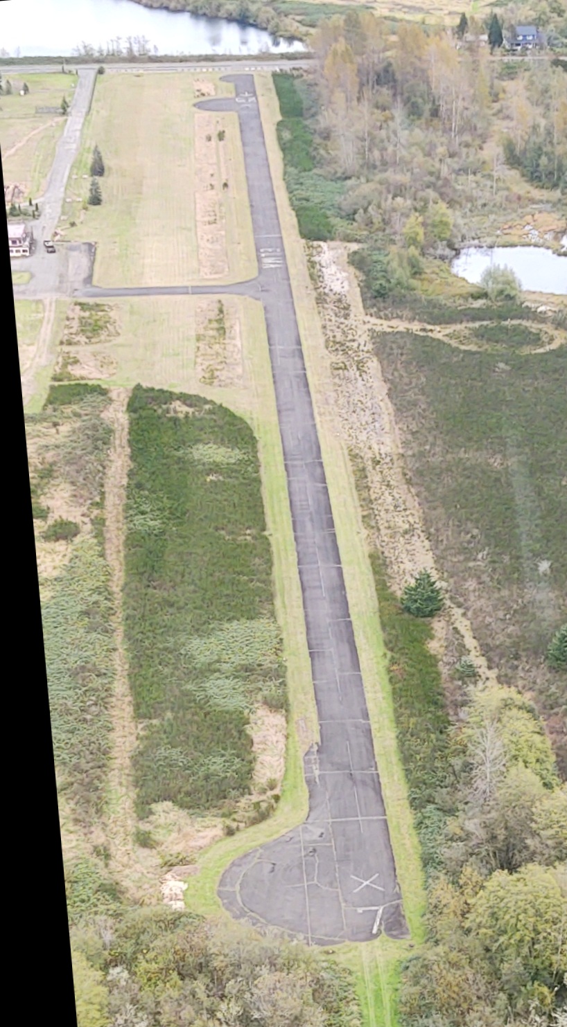
A 10/18/20 aerial view photo by Brian Reynolds looking east along Elma Municipal Airport's Runway 7.
B. Reynolds noted, “There are X's on the runway & the airport looks closed.
It looks like it was for sale as an airport recently, but I don’t think it’s for sale right now.”
No aircraft were visible on the field.
As of 2020, an undated photo showed a sign for the Happy Landings Cafe at the Elma Municipal Airport entrance.
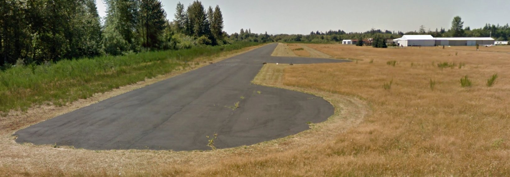
The 2/4/21 WSDOT Washington Skies (courtesy of John Townsley) reported, “Elma Municipal (1WA7) was recently closed to all aviation traffic.”
Lee Corbin reported in 2021 of a visit to Elma Airport, “Pretty sad. Grass growing up through the runway (but still usable), derelict hangars,
outdoor seating at the abandoned diner had bushes growing around the tables.
What’s funny is that the windsocks were in great shape, as if they had been replaced.”
Bob Bogash reported in 2021, “I confirmed today that Elma Airport has now closed.
Checking the aeronautical literature, it was still showing up until this week; when I updated my charts, I see it was dropped off the Sectional.”
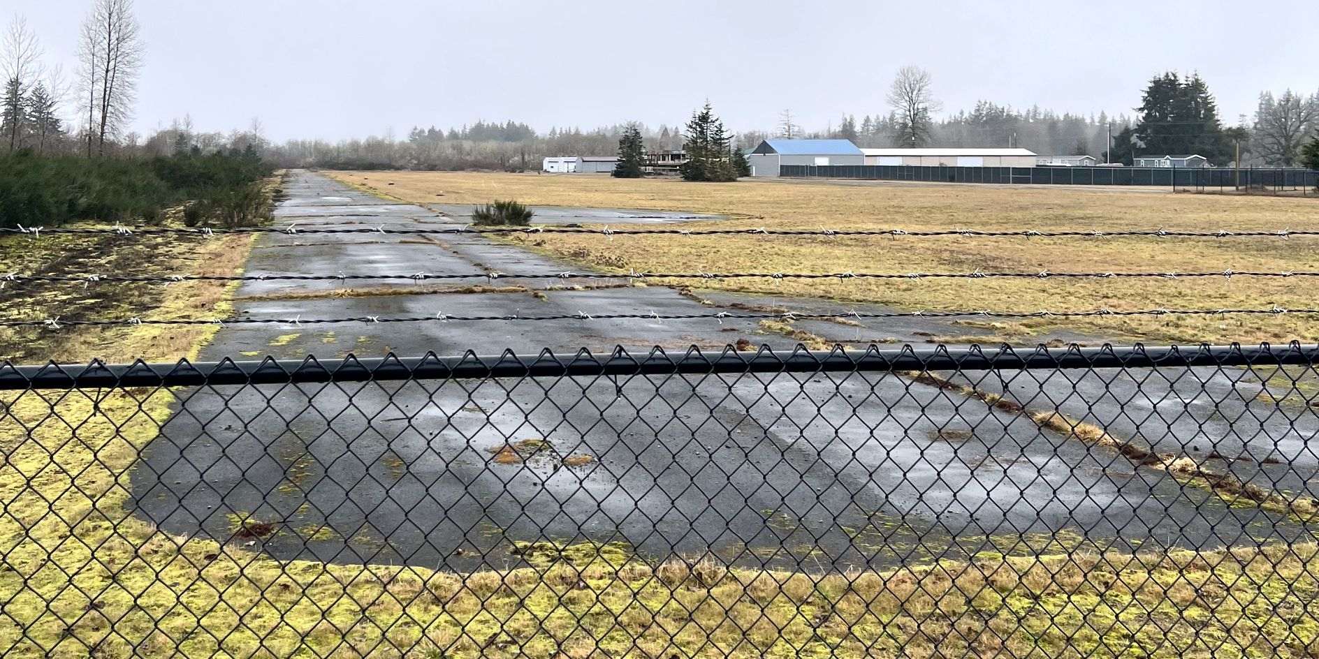
A 2/19/25 photo by Riley Wagner looking west along Elma Municipal Airport's Runway 25.
Riley noted, “Elma is in a deteriorating condition; it’s in a much worse state. The property looks completely abandoned, no sign of human activity, just a stray dog & a tattered windsock. The X’s on the runway are almost completely faded.”
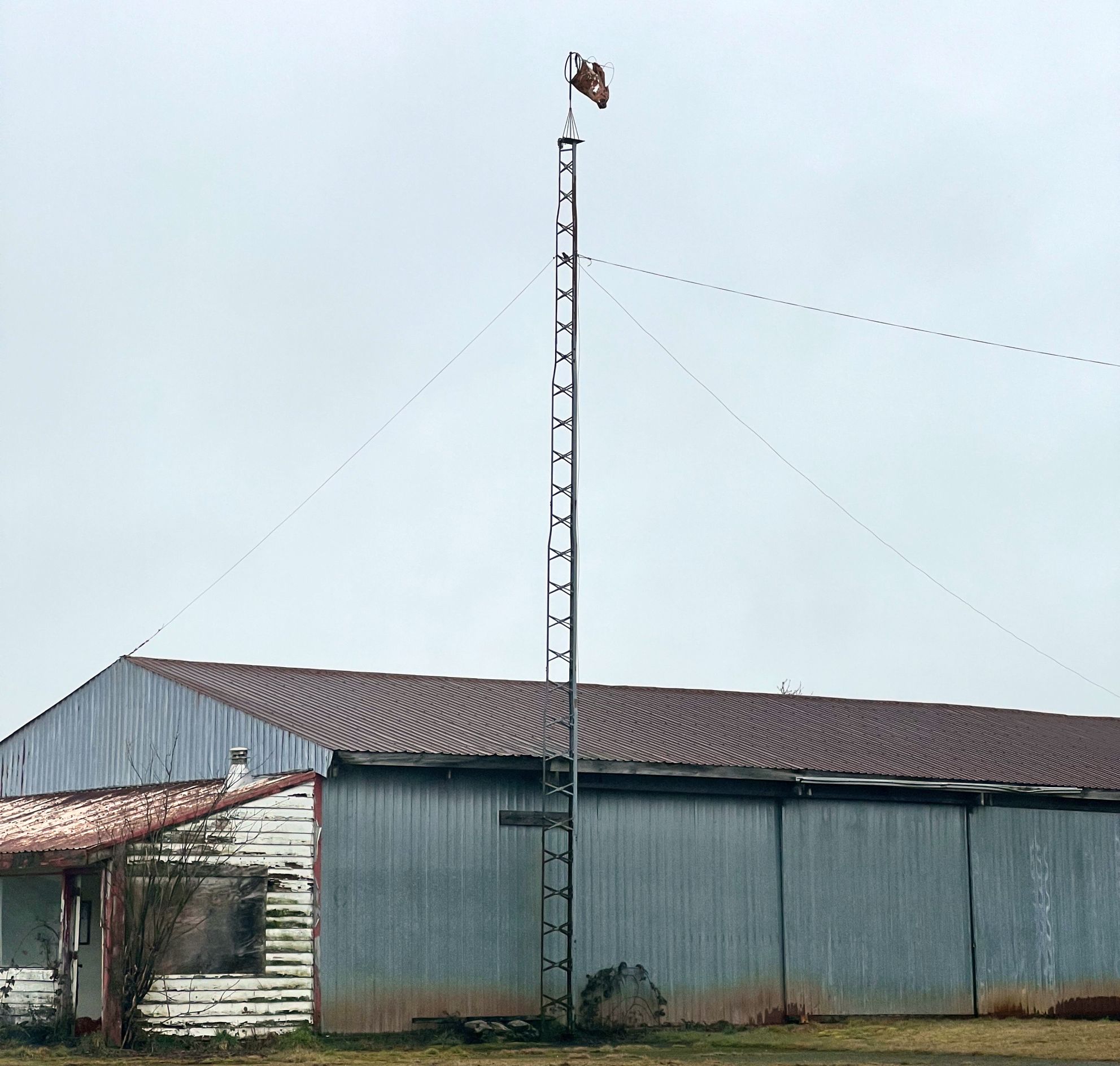
A 2/19/25 photo by Riley Wagner of a tattered windsock next to a former Elma Municipal Airport hangar.
Thanks to Brian Reynolds for pointing out this airfield.
____________________________________________________
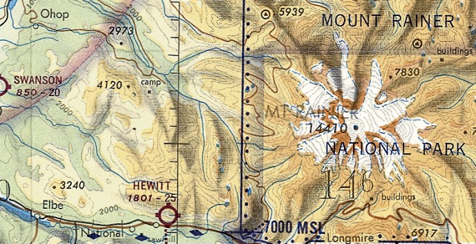
46.758, -122.018 (South of Seattle, WA)
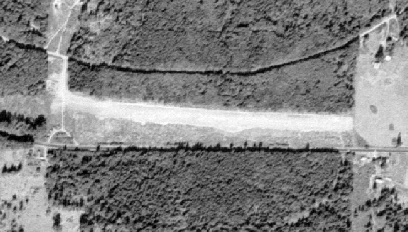
Hewitt Field, as depicted on a 1955 USGS aerial photo.
This small general aviation airport was evidently established at some point between 1952-55,
as it was not yet depicted on a 1952 aerial photo.
The earliest photo which has been located of Hewitt Field was a 1955 aerial view, which showed a single grass east/west runway.
According to Jonathan Westerling, “The founder of the airport was Walter Hewitt.”
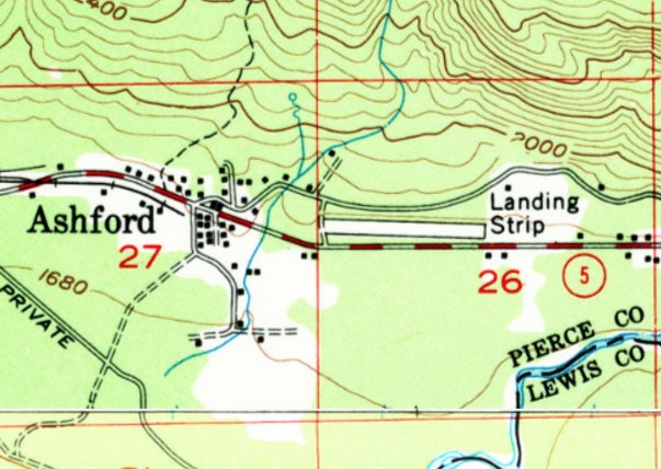
The earliest topo map de[iction which has been loccated of Hewitt Field was on the 1956 USGS topo map,
which depicted a single east/west runway, labeled simply as “Landing Strip”.
Hewitt Field was not yet depicted on the April 1959 Seattle Sectional Chart.
The earliest aeronautical chart depiction which has been located of Hewitt Field was on the October 1959 Seattle Sectional Chart.
It depicted Hewitt as having a 2,500' unpaved runway,
The 1963 Airman's Guide (courtesy of Jonathan Westerling) described Hewitt Field as having a 2,500' unpaved runway.
According to Karl Gruber, “Hewitt Field... We would land in there, hitchhike to Paradise, and climb the mountain.
James Beech was a well respected WW2 pilot & ran an aerial sightseeing business out of Hewitt Field.
He flew a Cessna 170 & later a 180. In the 1950s & 1960s he could be seen circling around the mountain almost any sunny summer day.”
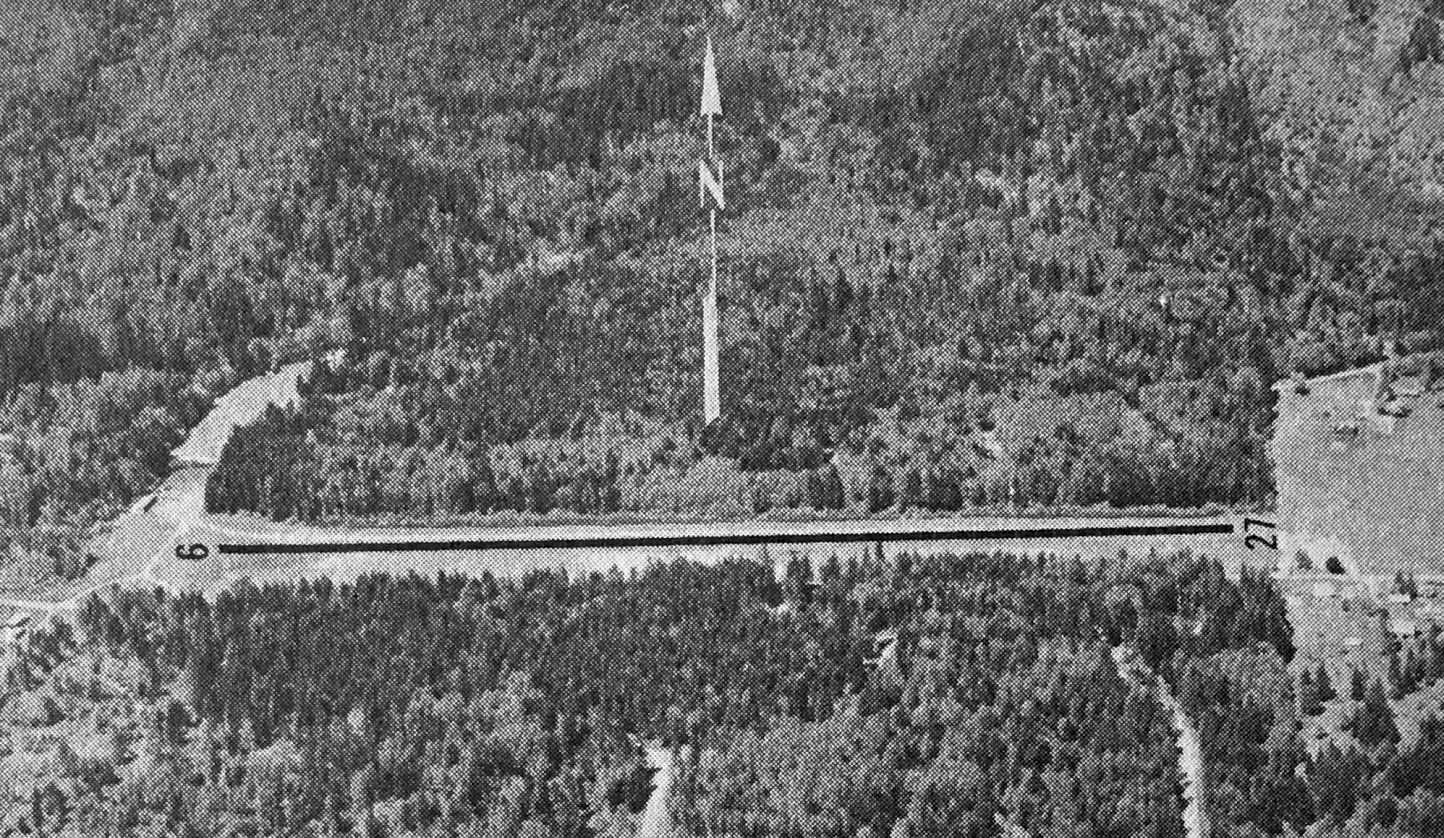
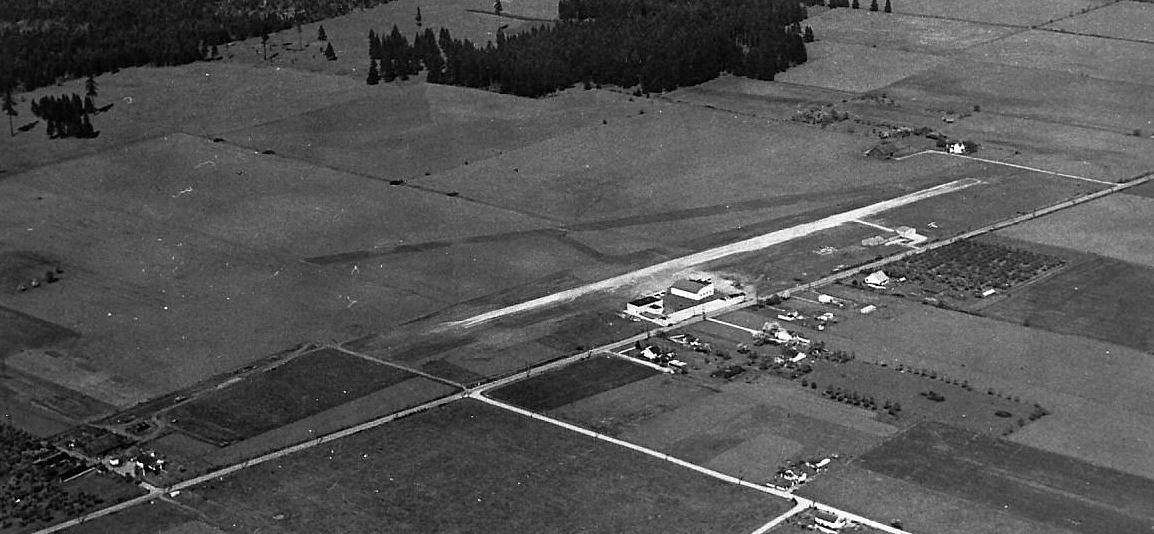
The only photo which is available showing Hewitt Field while it was open was an undated aerial view looking north from the 1971 WA Airport Directory (courtesy of Clayton Kimball).
It described Hewitt Field as having a 2,400' sod & gravel east/west runway, and listed the manager as James Beech.
The last aeronautical chart depiction which has been located of Hewitt Field was on the July 1971 Seattle Sectional Chart (courtesy of Ron Plante).
It depicted Hewitt as having a 2,500' unpaved runway,
The 1976 AOPA Airport Drirectory (courtesy of Jonathan Westerling) described Hewitt Field as a public-use airport having a 2,540' sod & gravel Runway 7/25 & hangars.
The operator was listed as Walter Hewitt.
By the time of the 1979 AOPA Airport Drirectory (courtesy of Jonathan Westerling), Hewitt Field's status had changed to a private airfield.
It was said to have a 2,470' gravel & turf Runway 7/25.
The last photo which has been located showing an aircraft at Hewitt Field was a 1983 aerial view, which showed one light single-engine plane parked northeast of the runway.
The 1983 AOPA Airport Drirectory (courtesy of Jonathan Westerling) said Hewitt Field had an on-field restaurant,
and had a 2,470' gravel & turf Runway 7/25 & hangars.
A 1984 aerial view showed Hewitt Field remained intact.
Hewitt Field evidently was closed at some point between 1983-89,
as it was no longer depicted on the 1989 Seattle Sectional Chart (according to Jonathan Westerling).
Jonathan Westerling reported, “This corresponds with the construction date of the Nisqually Lodge hotel which was built on the middle of the airfield in 1989.”
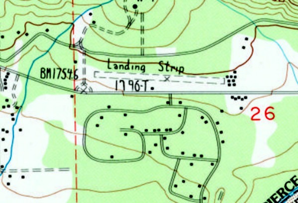
Hewitt Field was depicted on the 1990 USGS topo map as an east/west unpaved runway,
labeled simply as “Landing Strip”, with several small buildings on the east side.
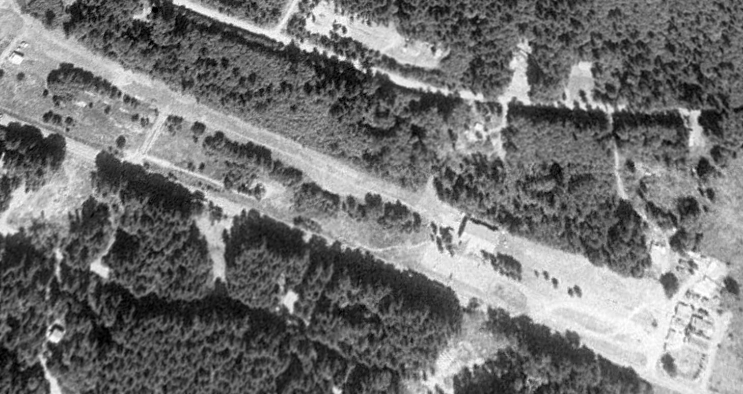
A 1994 USGS aerial view looking northwest depicted Hewitt Field after it had been closed, with a building having been built over the center portion of the runway.
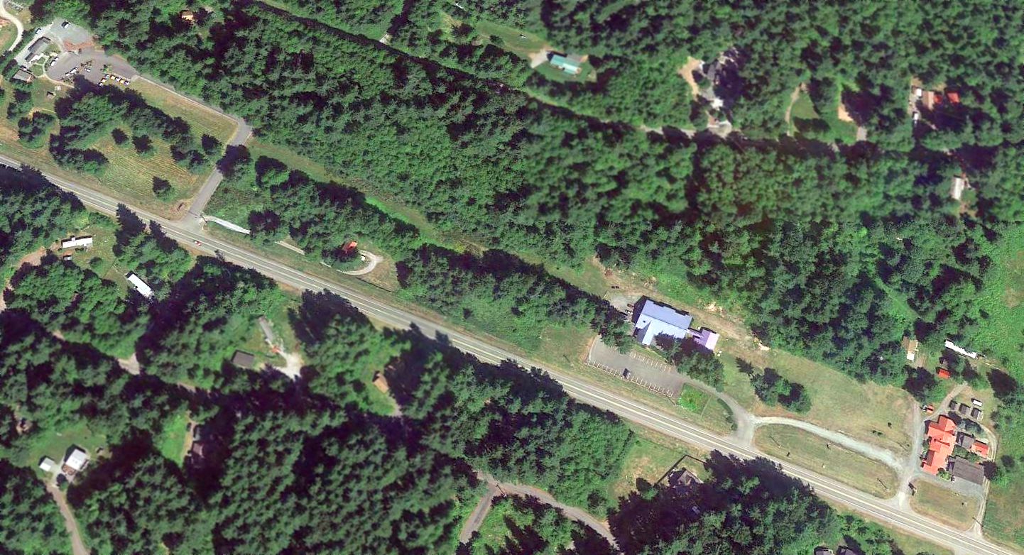
A 2014 aerial view looking northwest showed Hewitt Field's former runway remained somewhat recognizable.
A 1/12/19 photo by Jonathan Westerling looking east along the remains of Hewitt Field's runway.
Jonathan reported, the view is “looking roughly towards Mt. Rainier & the trees which are increasingly overtaking the runway.
It is mostly grown in at this point, and couldn't find any relics of its aviation use.
But it is literally minutes from the National Park entrance, so the views when taking off & landing on this field must have been sublime.”
A 1/12/19 photo by Jonathan Westerling looking west “toward the Nisqually Lodge hotel” on the edge of the site of Hewitt Field.
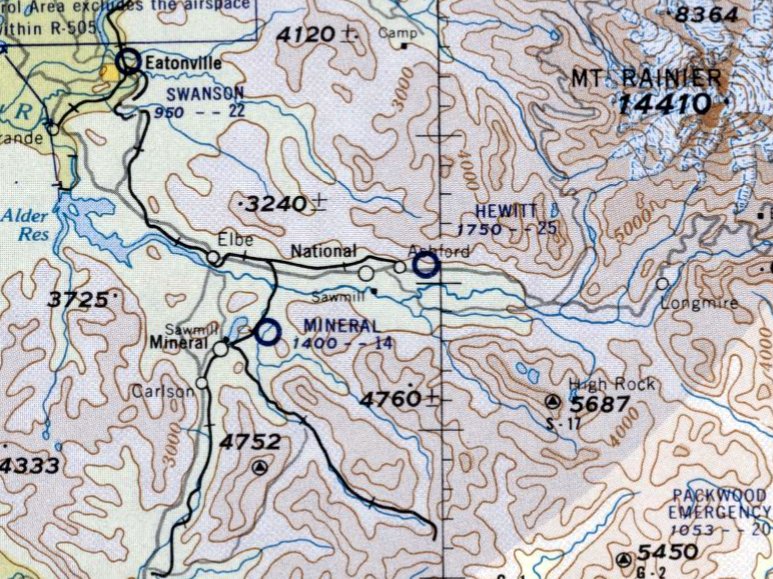
The site of Hewitt Field is located east of the intersection of Route 706 & Mt Tahoma Canyon Road East.
Thanks to Karl Gruber for pointing out this airfield.
____________________________________________________
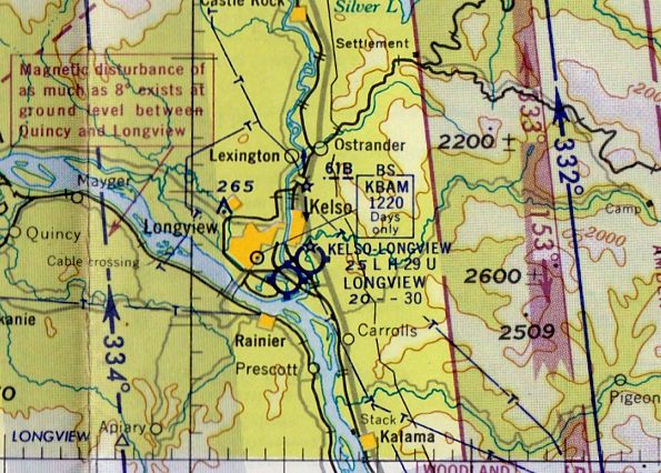
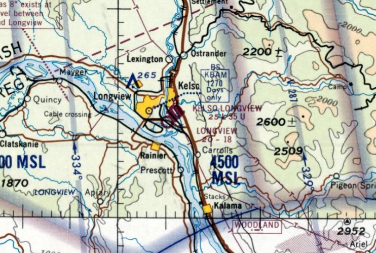
Longview Airport / Taylor Airport, Longview, WA
46.11, -122.92 (North of Portland, OR)
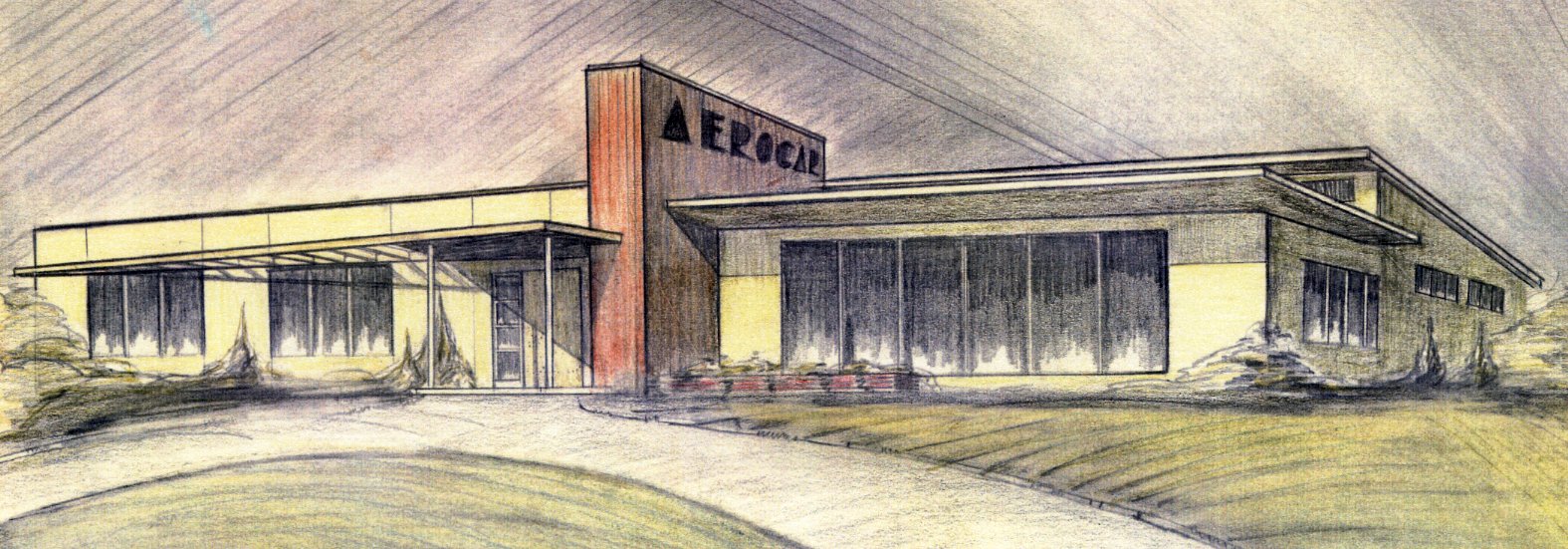
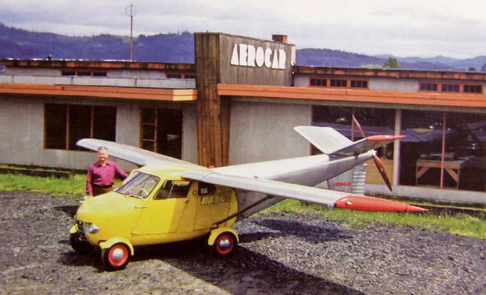
A 1947 artist's conception by Larry Rice of the Aerocar “plant” at Taylor Airport (from the collection of Molt Taylor, courtesy of Jake Schultz).
Longview / Taylor Airport was not yet depicted on the April 1948 Seattle Sectional Chart.
Taylor Airport was the factory airport for Taylor Aircraft, at which founder Molt Taylor developed the Aerocar,
a “roadable” aircraft which could be converted to a car by quickly removing the wings & rear fuselage.
The earliest aeronautical chart depiction which has been located of Longview Airport was on the October 1948 Seattle Sectional Chart,
which depicted Longview as having a 2,000' unpaved runway.
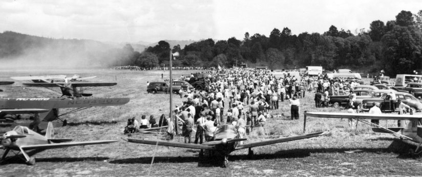
A 7/4/49 photo of the Junior Chamber of Commerce Airshow at Taylor Airport (from the collection of Molt Taylor, courtesy of Jake Schultz).
According to Jake Schultz's book “A Drive In The Clouds”, the first public showing of the Aerocar was at a Junior Chamber of Commerce fly-in at the field next to the factory on 7/4/49,
and the Aerocar's first flight was on 11/4/49.
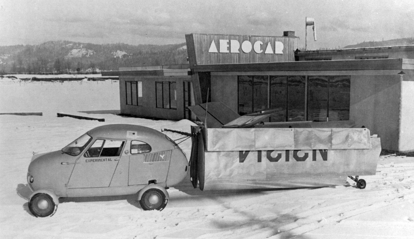
A 1949 photo of an Aerocar & its trailered wings & fuselage in front of the Aerocar “plant” at Taylor Airport (from the collection of Molt Taylor, courtesy of Jake Schultz).
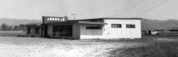
A 1949 photo of the Aerocar “plant” at Taylor Airport (from the collection of Molt Taylor, courtesy of Jake Schultz), with 2 high-wing taildraggers in the background.
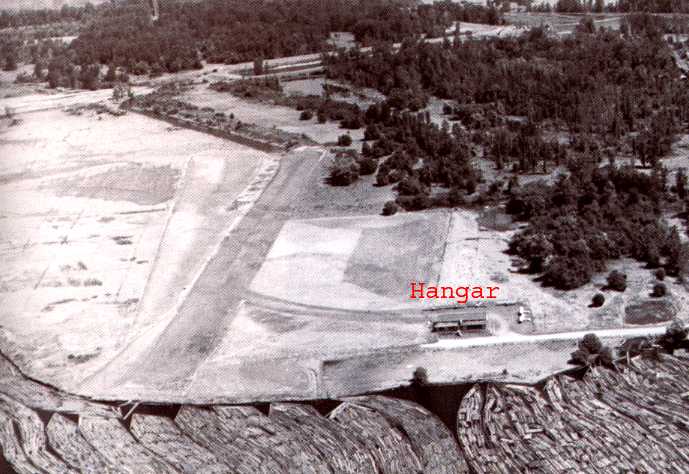
A circa 1949 aerial view looking east along the Taylor Airport runway (courtesy of Scott Kimball),
showing the hangar which would eventually become home to the Aerocar operation.
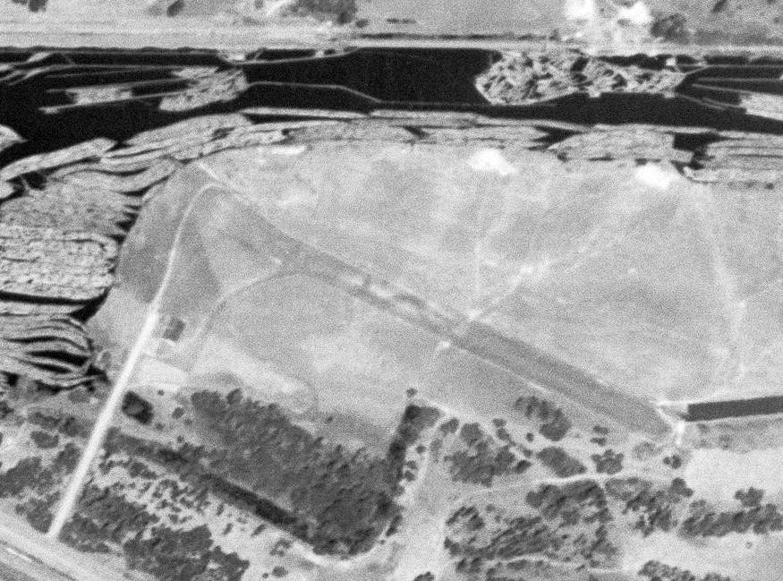
A 10/25/51 USGS aerial photo showed Taylor Airport to have an unpaved northwest/southeast runway, with the small Aerocar factory on the southwest side.
There were no aircraft visible on the field.
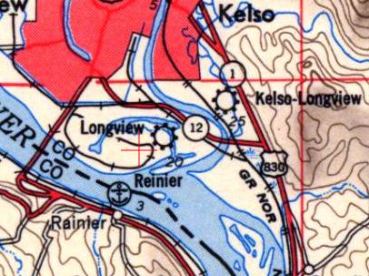
Longview Airport, as depicted on the 1953 USGS topo map.
An undated (circa 1950s) photo of Molt Taylor & one of his prototype Aerocars in front of the Aerocar factory at Taylor Airport.
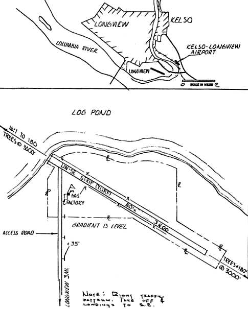
The location & layout of Longview Airport from the 1959 Washington Pilot's Guide (courtesy of Jerry Sorrell).
It depicted Longview Airport as having a single 3,400' turf northwest/southeast runway, with a factory on the southwest side.
The remarks said “Aerocar 'Flying Automobiles' built at field.”
Only 6 Aerocars were built. Molt Taylor tried to arrange deals with several manufacturers for mass production, but none came to fruition.
The April 1959 Seattle Sectional Chart (courtesy of Paul Columbus) depicted Longview Airport as having a 3,000' unpaved runway.
Longview Airport was still depicted on the 1962 USGS topo map.
Jerry Sorrell recalled of Taylor Airport, “When I started to fly in the mid-1960s, this field still existed.”
According to Jake Schultz, “Molt sold the Longview Airport in the mid-1960s (I believe to Longview Fiber) and those funds were used to acquire a smaller building & develop the Aerocar Model III.
The original Aerocar plant was used by a sportsman club for a while after Molt Taylor moved to the 3rd Avenue location.”
The last aeronautical chart depiction which has been located of Longview Airport was on the June 1967 Seattle Sectional Chart.
However, Longview Airport's depicted runway length had shrunken to a mere 1,800'.
Longview Airport was evidently closed at some point in 1967,
as it was no longer depicted on the December 1967 Seattle Sectional Chart.
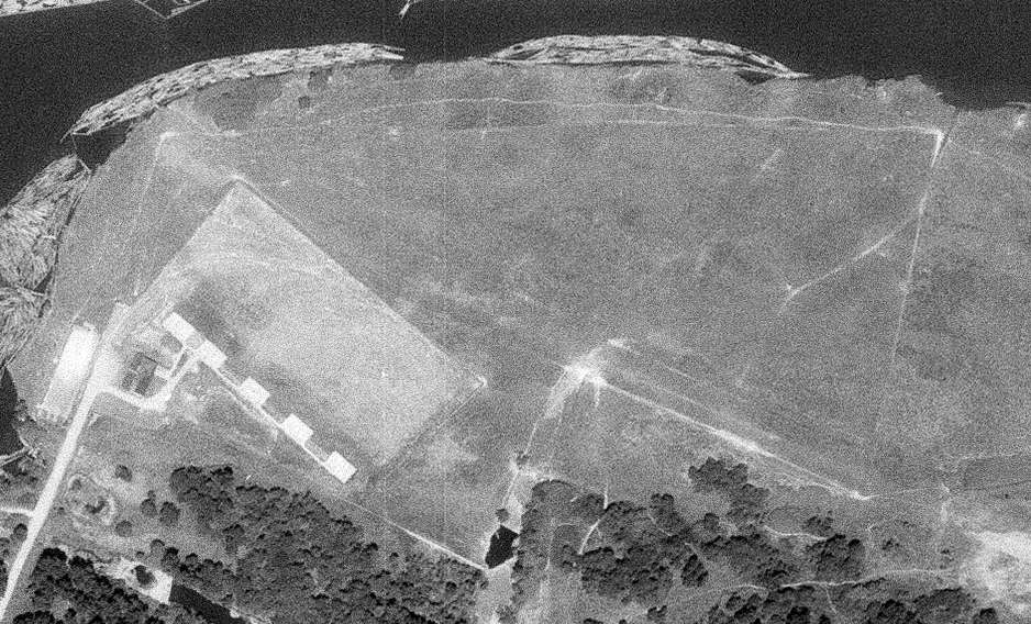
A 10/8/70 USGS aerial photo showed that an unidentified series of 5 concrete pads had been built on the west side of Taylor Airport,
which otherwise showed no signs of current aviation usage.
A 7/15/90 USGS aerial view showed a faint trace remaining of Taylor Airport's northwest/southeast runway, and the foundation of the Aerocar factory was still visible on the west side.
The foundation of the Aerocar factory was still visible in a 1994 aerial photo.
Jake Schultz recalled, “Molt Taylor & I drove to the location of Longview Airport in the mid-1990s.
He sat in my truck (he was less mobile due to a stroke) & pointed out the exact location of the original Aerocar plant foundation.
I was able to walk around on that abandoned foundation & pet the cows that were grazing in the field – the sight of which brought Molt to uncontrollable laughter
(he had grown up near Portland Oregon where his father was a cattle rancher!).”
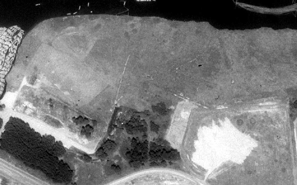
A 2000 aerial photo shows that the foundation of the Aerocar factory was wiped clean at some point between 1994-2000,
but the outline of a portion of the Taylor Airport runway remained recognizable.
A 2003 aerial photo showed that a new road had been built through the center of the Taylor Airport site at some point between 2000-2003,
erasing the last traces of the runway.
A 9/26/11 aerial view shows no trace remains at the site of Taylor Airport.
Jerry Sorrell observed in 2012, “The area has been reconstructed for other industrial purposes; now used for wood products stockpile.”
The site of Taylor Airport is located east of the intersection of Fibre Way & East Mill Road.
____________________________________________________
Evergreen Field (59S) / Suggs Airport, Vancouver, WA
45.62, -122.53 (North of Portland, OR)
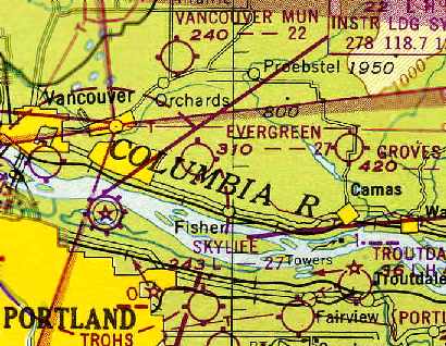
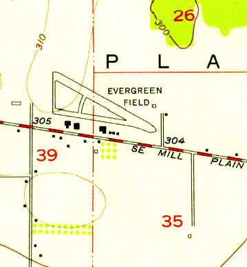
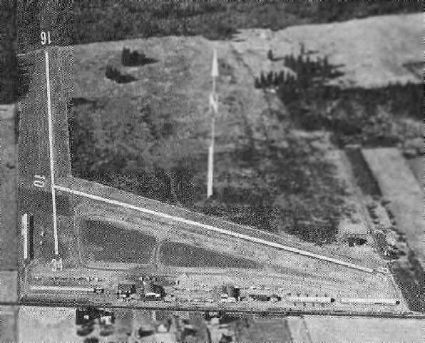
Evergreen Field, as depicted on the October 1948 Portland Sectional Chart (courtesy of Chris Kennedy).
Evergreen Field was founded in 1946, according to an article on Aero-news.net.
It was described as “a place where a flyer could stop for small town hospitality,
kids could earn flight time washing planes, students could learn to fly in taildraggers or contemporary planes.”
According to a 2/16/06 Vancouver Columbian article by Thomas Ryll (courtesy of Jerry Sorrell),
in “August 1944, Roy C. Sugg [was] granted a special conditional permit by the county planning commission for an airport on Mill Plain Road, 7 miles east of Vancouver."
In “1945, Wally Olson [bought] the airport.”
The earliest depiction of Evergreen Field which has been located was on the October 1948 Portland Sectional Chart (courtesy of Chris Kennedy).
It depicted Evergreen as having a 2,700' unpaved runway.
Jerry Sorrell recalled, “Evergreen Field... I knew the owner, Wally Olson. I think Wally bought the airport from Mr. Suggs after WW2.”
The earliest photo which has been located of Evergreen Field was a circa 1940s aerial view looking northeast (courtesy of John Guilmette).
It depicted Evergreen as having 2 east/west runways, with a few small hangars & 2 light planes on the south side.
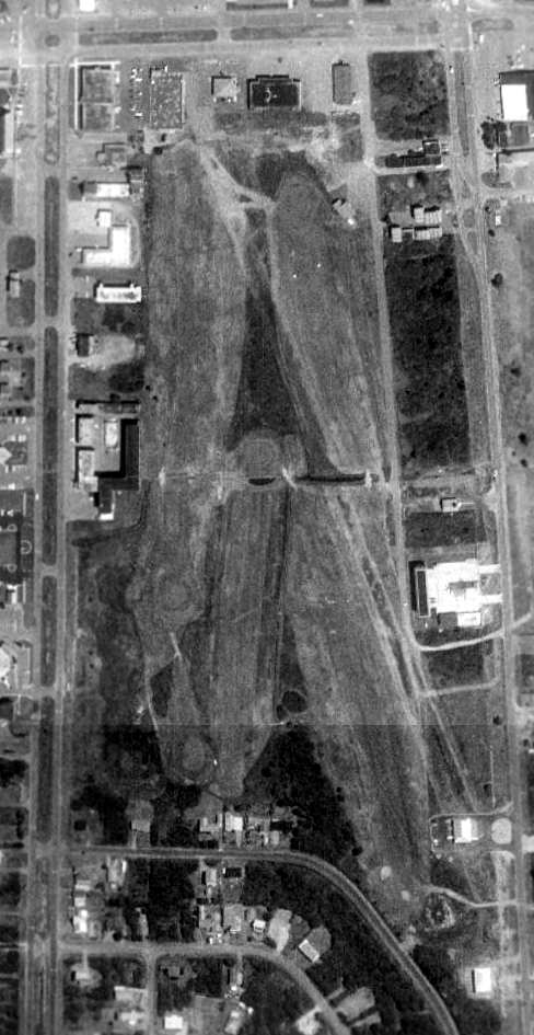
A 7/27/51 USGS aerial view depicted Evergreen Field as having 3 unpaved runways, with a few small hangars & 15 light planes on the south side.
The September 1954 Portland Sectional Chart (courtesy of Chris Kennedy)
continued to depict Evergreen as having a 2,700' unpaved runway.
The 1954 USGS topo map depicted Evergreen Field as having a northwest/southeast runway, with a taxiway & 6 buildings along the south side.
Charles Luce recalled, “Evergreen was a bucolic, quintessential grass strip
when I was a kid living in Vancouver in the early 1960s.
We used to ride our bikes out the field to watch planes take off & land.
At that time, Mill Plain road was a rather desolate 2-lane highway. Only a few cars to contend with.”
According to a 2/16/06 Vancouver Columbian article by Thomas Ryll (courtesy of Jerry Sorrell),
famed pilot Charles Lindbergh visited Evergreen Field several times in the early 1960s.
Jerry Sorrell recalled, “Wally [Olson] told me years ago that Mr. Lindbergh's trips to the area were to visit his wife’s relatives in nearby Ridgefield.
He told me that Mr. Lindbergh would fly the planes on occasion. In those years, it would probably have been the Taylorcraft & Aeronca.
Wally said that Mr. Lindbergh wanted to remain anonymous, and Wally honored that request.
I always wondered if the Aeronca & Taylorcraft I leaned to fly in 1967, were the ones that Mr. Lindbergh may have flown.”
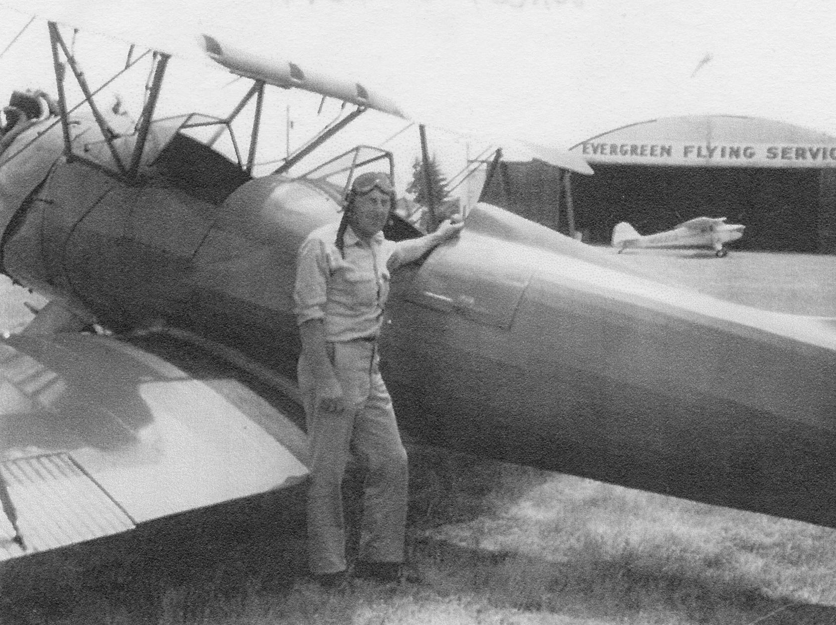
A circa 1960s photo of Evergreen Field owner Wally Olson & a UPF biplane in front of the Evergreen Flying Service hangar (courtesy of John Guilmette).
Evergreen Field was home to the Northwest Antique Airplane Club & Evergreen Fly-In since 1964,
according to an article on Aero-news.net.
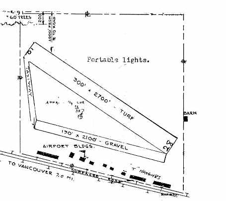
The 1966 Washington Pilot's Guide (courtesy of Chris Kennedy)
depicted Evergreen Field as having a 2,700' turf Runway 10/28
and a second 2,100' gravel Runway to the south.
A row of T-hangars was depicted along the south side of the field.
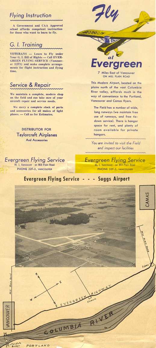
A 1960s brochure (featuring an undated aerial view looking northeast) from “Evergreen Flying Service – Suggs Airport” (courtesy of Jerry Sorrell).
Jerry Sorrell recalled, “Evergreen Field... I learned to fly there in 1967 & knew the owner, Wally Olson. He gave me the ad.”
According to a 2/16/06 Vancouver Columbian article by Thomas Ryll (courtesy of Jerry Sorrell),
in “April 1968, the county approved a plan for Olson's 88-lot, 42-acre Evergreen Airpark subdivision
for residents with 'take home' planes that are taxied from the airport's main runways.”
The July 1969 Portland Sectional Chart (courtesy of Chris Kennedy)
depicted Evergreen as having a 2,600' unpaved runway.
Jim Garver recalled, “I learned to fly at Evergreen Field. Wally Olson was my instructor there.
I solo'd in Taylorcraft 96202, which Charles Lindberg flew, so Wally told me.”
Evergreen Field gained a paved main runway & a crosswind grass runway at some point between 1969-71,
as the 1971 Washington Pilot's Guide (courtesy of Chris Kennedy)
depicted Evergreen as having a 2,600' Runway 10/28 (of which 2,300' was said to be blacktop),
along with a grass Runway 16/34.
Another row of T-hangars had also been added on the southwest corner of the field.
According to a 2/16/06 Vancouver Columbian article by Thomas Ryll (courtesy of Jerry Sorrell),
in “April 1973, the state's aeronautics director predicted a bleak future for Evergreen Airport,
saying it may not be able to stave off higher taxes & development pressure.”
By “June 1973, Evergreen had grown to 9 hangars & 140 planes, about half its capacity.”
According to a 2/16/06 Vancouver Columbian article by Thomas Ryll (courtesy of Jerry Sorrell),
in “December 1977, Olson told county commissioners that plans to extend 136th Avenue would kill chances for Evergreen's expansion.
The avenue was extended.”
The January 1982 Seattle Sectional Chart (courtesy of Paul Columbus)
depicted Evergreen Airport as having a 2,400' paved northwest/southeast runway.
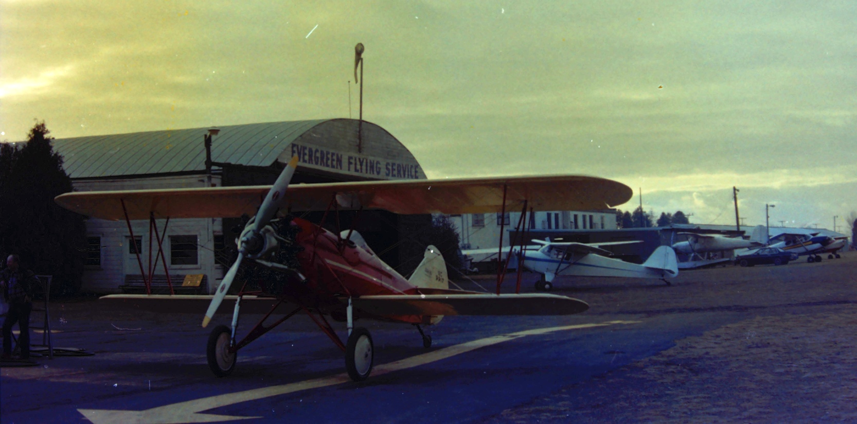
A circa 1980s/90s photo of a biplane & a variety of light single-engine aircraft in front of the Evergreen Flying Service hangar (courtesy of John Guilmette).
John Guilmette observed, “The old gray bench [on which Charles Lindbergh had sat] was below the windows of his old hangar.”
A circa 1980s/90s photo of a Cessna UC-78 at Evergreen Field (courtesy of John Guilmette).
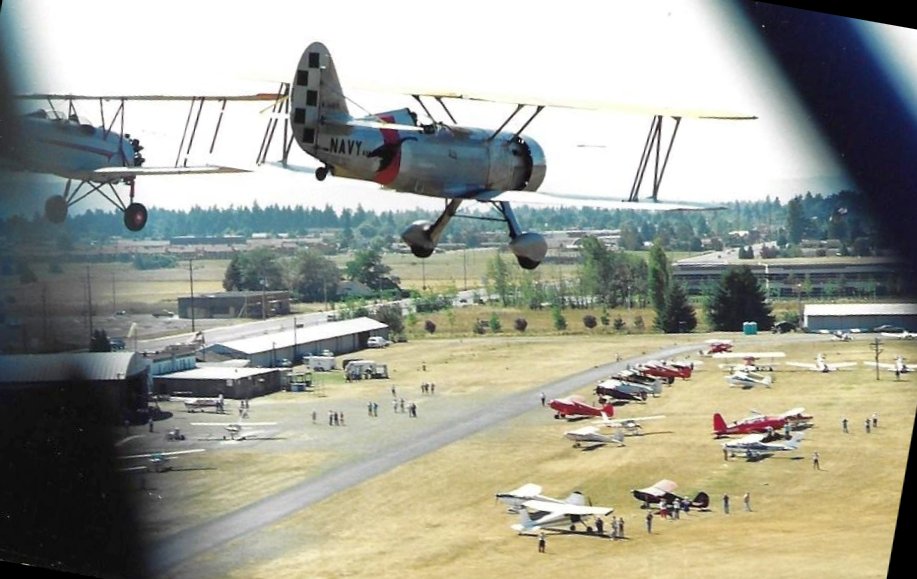
A circa late 1980s aerial view by John Guilmette of 2 biplanes overflying a show at Evergreen Field.
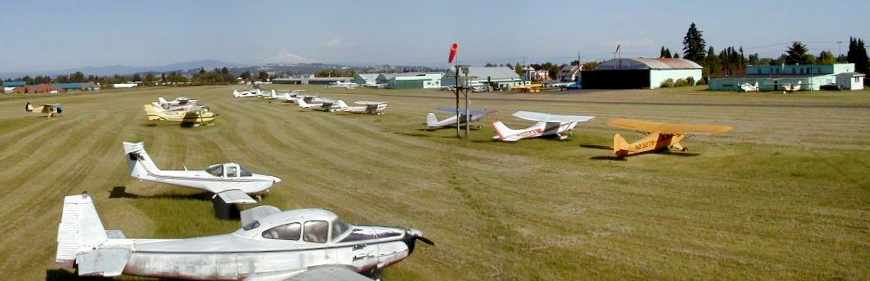
A 1990 USGS aerial view looking northeast depicted dozens of light planes on the south side of Evergreen Field's paved runway,
and several long hangars extending along the north/south grass runway.
The 1995 USGS topo map depicted Evergreen Field as having a single paved northwest/southeast runway (with a parallel taxiway),
along with an unpaved north/south runway.
A circa 1966-97 photo by John Guilmette of a fly-in at Evergreen Field.
John Guilmette recalled, “I used to work at Evergreen Field.
Wally Olson was the owner & he had an old wooden bench next to his hangar that was very decrepit
but when anyone would ask why he didn't get rid of it, he told them that that is where Lindbergh sat back when he came here once... it had to stay.”
Old gray bench just below the windows of his old hangar in 2nd pic... and Evergreen Field at different times in 'history'.
I knew Wally well, worked with him a bit & he let me fly his UPF-7 & we got his old ZQC-6 cabin Waco running again, and I flew that as well.”
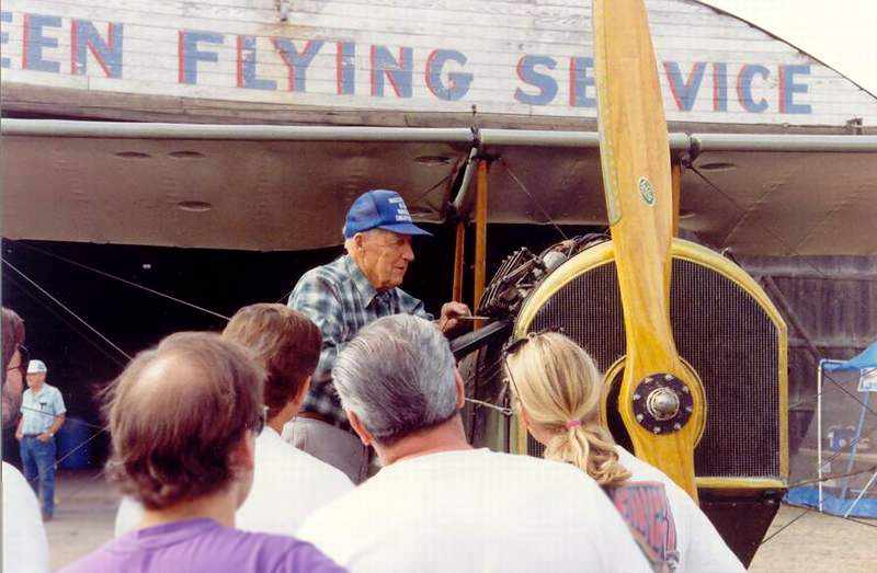
A late 1990s photo of Evergreen Airport owner Wally Olson, in front of the Evergreen Flying Service hangar (courtesy of Collin).
According to a 2/16/06 Vancouver Columbian article by Thomas Ryll (courtesy of Jerry Sorrell),
Evergreen Field owner/operator Wally Olson died of cancer at age 86 on 7/17/97.
In “October 1997, the North-South Airpark Association, consisting of homes along a grass strip north of & connected to the airport,
won a 4-year legal battle when the state Court of Appeals concurs with a local judge's ruling that residents can use the area for takeoffs & landings.
The private airstrip will remain open after Evergreen closes.”
In “April 1998, after hearing a storm of opposition, the Vancouver Planning Commission unanimously voted
to recommend against rezoning for apartments a piece of land that had been part of Evergreen's north-south runway.”
A May 2001 panoramic shot by Charles Luce of Evergreen Field.
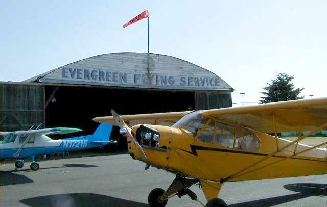
A May 2001 photo by Charles Luce of the Evergreen Flying Service hangar.
According to a 2/16/06 Vancouver Columbian article by Thomas Ryll (courtesy of Jerry Sorrell),
in “June 2001, the same day that Port of Vancouver officials announced they would not buy the airport,
the Olson family puts the 57-acre property up for sale, saying, 'The well has now run dry.'”
In November 2001, “The Olsons filed an application with the city, proposing development of the airport into commercial, light-industrial & office uses.”
In “April 2002, four years after buying 17 acres of the airport's north-south runway from the Olson family,
developer Walt Musa gained the city's OK to rezone the property.”
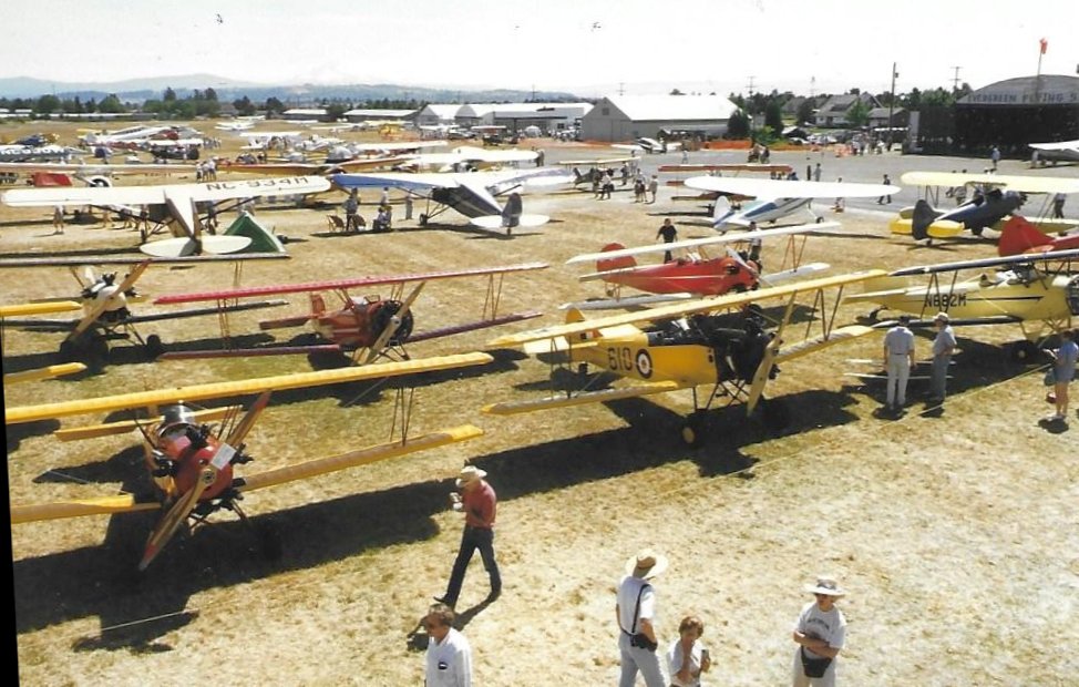
In “August 2002, the Northwest Antique Airplane Club's 43rd & final Evergreen event took place.”
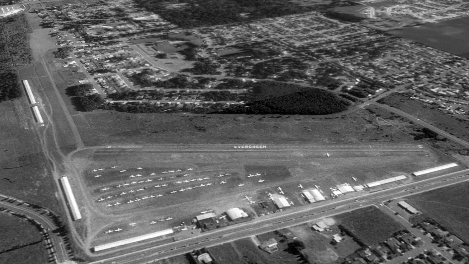
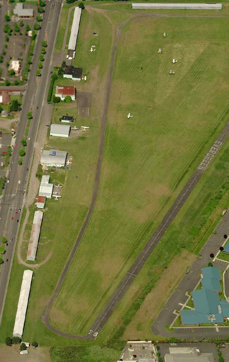
The 2002 USGS aerial photo depicted Evergreen Field
as being a very well-used airport, with over 50 aircraft visible parked on the field.
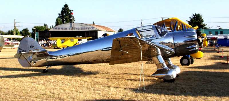
An 8/17/02 photo by Russell Williams of a beautiful 1938 Ryan SCW in front of the Evergreen Flying Service hangar.
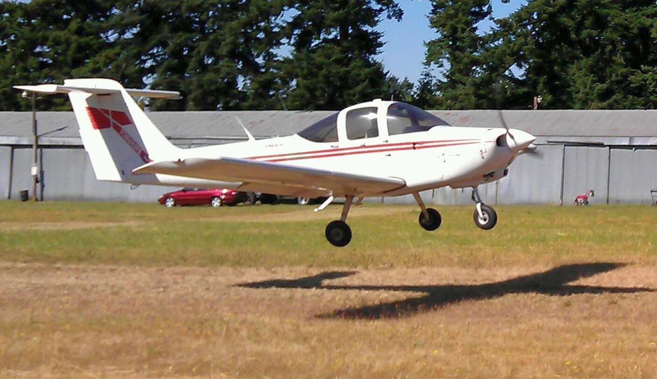
A 2004 photo by Doug Porter of his Piper Tomahawk N2566E taking off from Evergreen's grass runway.
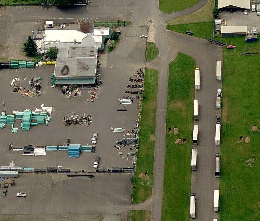
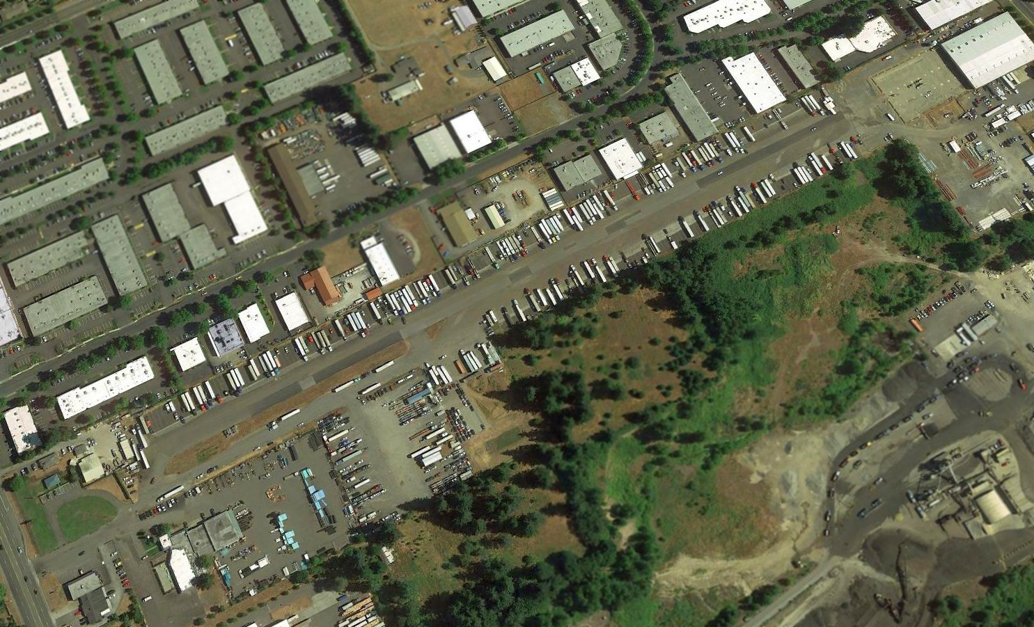
Doug recalled, “While the main east/west runways were being developed, the old north/south runway hangars were being rented out as storage units.
I stayed until the very end hiding out in one of those remaining dirt-floor hangars.”
The last aeronautical chart depiction which has been located of Evergreen Field
was on the Portland inset of the June 2005 Seattle Sectional Chart (courtesy of Mitchell Hymowitz).
It depicted Evergreen as having a single 2,100' paved northwest/southeast runway.
A 2005 aerial view looking northeast depicted a dozen light planes still remaining at Evergreen Field.
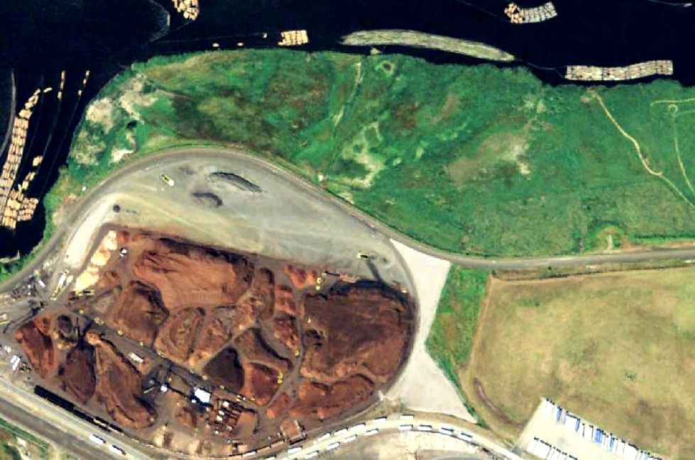
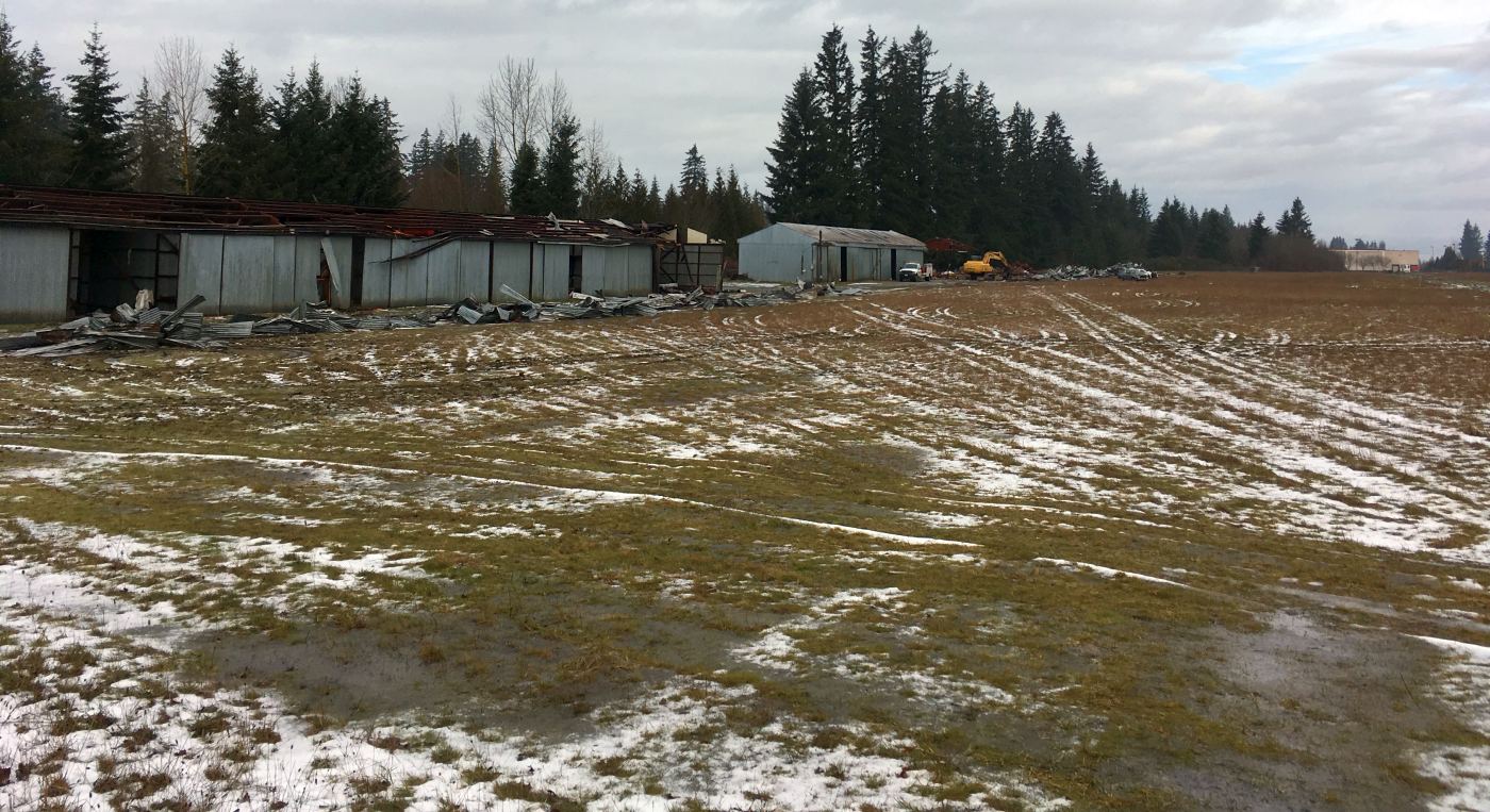
Unfortunately, the end for Evergreen Field came in 2006,
according to an article entitled “After 60 Years, Vancouver's Evergreen Field Shuts Down” on Aero-news.net.
The Northwest Antique Airplane Club held its final fly-in event at Evergreen in 2006,
“a bittersweet farewell party that saw over 250 guests & over 50 airplanes in attendance.
Until the flight school closed recently, Wally's original training fleet included several 1946 T-Crafts & a Cub -
and folks were welcome to wander around, poke a nose into an open hangar & say hello.
A multi-use business park - sporting with airport design cues -
will replace one of the last, great, old airports in the Vancouver-Portland area.
Somehow, that just don't seem right.”
In its last year of operation, the FAA Airport Facility Directory data for Evergreen Field described it as having a 2,155' asphalt Runway 10L/28R
and a parallel 2,000' turf Runway 10R/28L.
The field was home to a total of 165 aircraft, and it conducted an average of 186 takeoffs or landings per day.
A circa 2006 aerial view looking west at Evergreen Field,
showing 10 single-engine aircraft parked on the field.
According to Charles Luce, “As Vancouver & Camus grew towards each other,
Mill Plain boomed with big box stores & housing developments.
Evergreen survived only as long as Wally Olson owned it.
After he died, the Olson Family claimed it could no longer afford to keep the airport open,
which sounds plausible considering what insurance & taxes must have become.
Of course, I'm also sure they made a boodle selling this prime lot on Mill Plain.”
Evergreen Field was scheduled to close on 7/18/06.
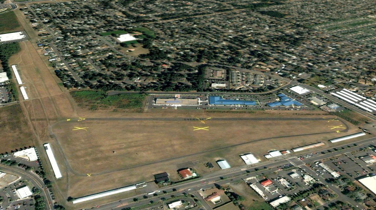
A sad sight for anyone who loves aviation: a 2006 aerial view looking northeast, showing multiple closed-runway “X” symbols over Evergreen Field.
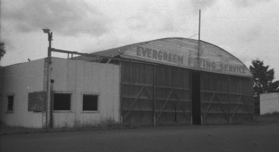
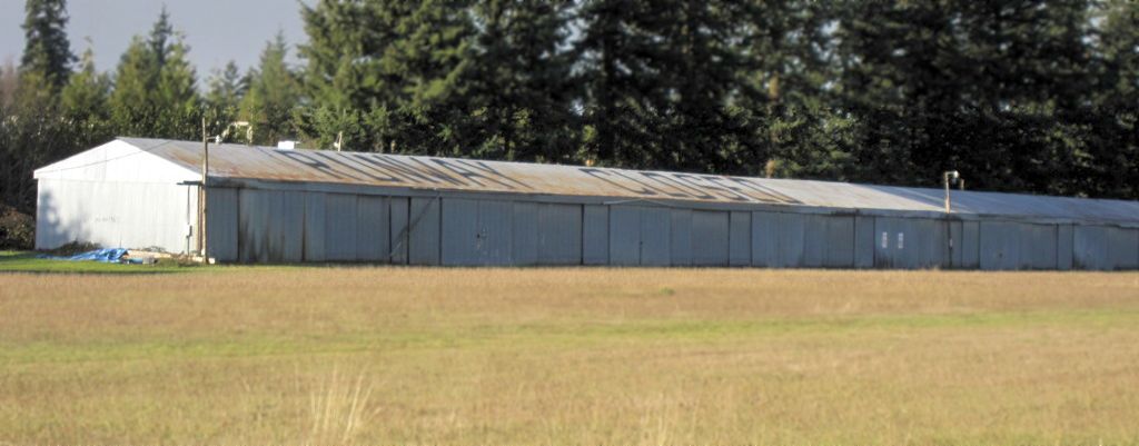
A 2007 photo by Joseph Kumanchik of the front of the Evergreen Flying Service hangar,
taken while “while the developers were waiting for plan approvals & proceeded with the demo[lition] work.”
A 2007 photo by Joseph Kumanchik of the rear of the Evergreen Flying Service hangar.
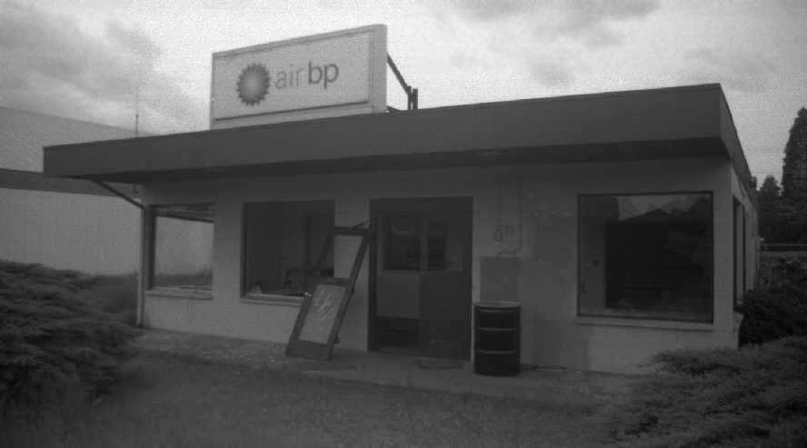
A 2007 photo by Joseph Kumanchik of the Evergreen Flying Service office.
Joseph Kumanchik reported in 2008, “The buildings are all gone now & development has begun.”
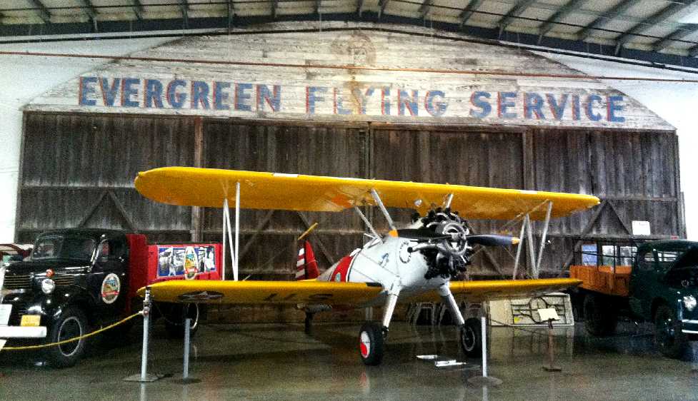
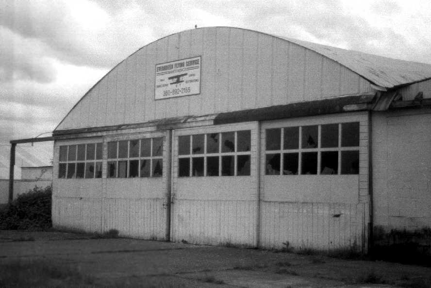
A 2012 photo by Patrick Joyce of the hangar wall bearing the sign “Evergreen Flying Service”,
saved from the wrecking ball & on display in the Western Antique Aeroplane & Automobile Museum.
Thank goodness that someone thought to save this relic of Washington general aviation for posterity.
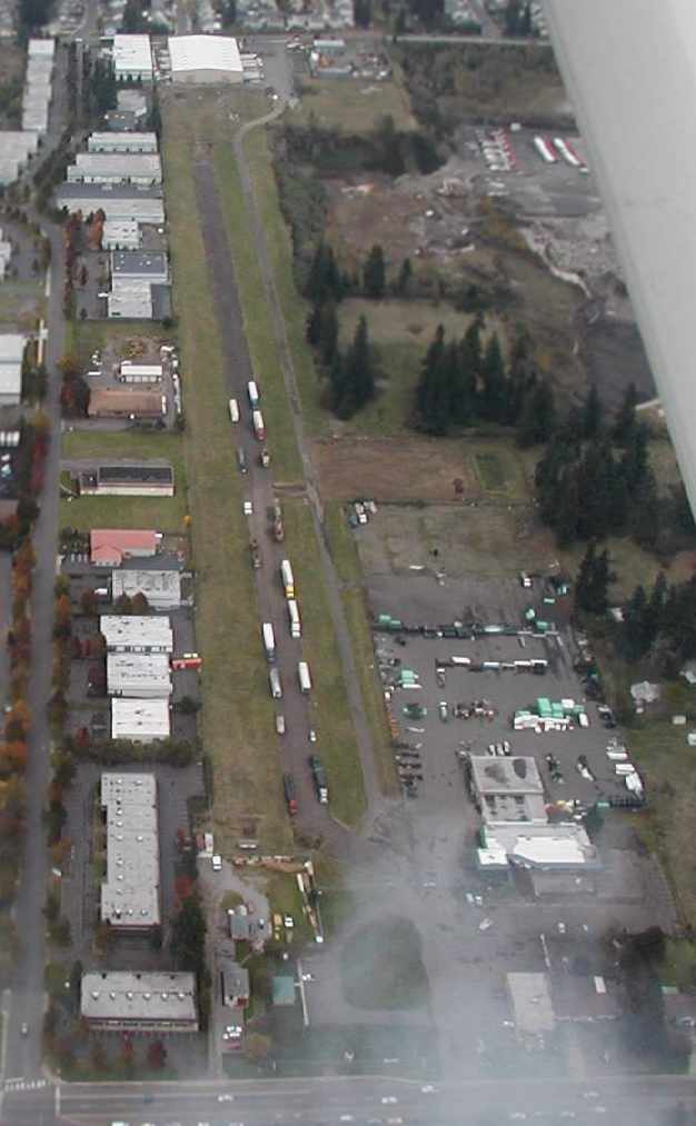
An 11/29/14 photo by Jonathan Westerling, “looking northwest along the remnants of Runway 28” at Evergreen Field.
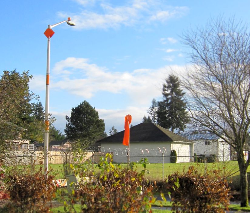
An 11/29/14 photo by Jonathan Westerling: “A windsock & a well-marked streetlight still mark the north end of Runway 16 at Evergreen.”
An 11/29/14 photo by Jonathan Westerling: “A closeup of the remaining hangars along the north/south runway at Evergreen spells out 'RUNWAY CLOSED'.”
Doug Porter recalled, Piper Tomahawk “N2566E's mark in history was to be absolutely the last bird to fly out of 59s (Evergreen Airport) off grass Runway 34 in May 2015.
Not bad considering it's been closed since 2006.”
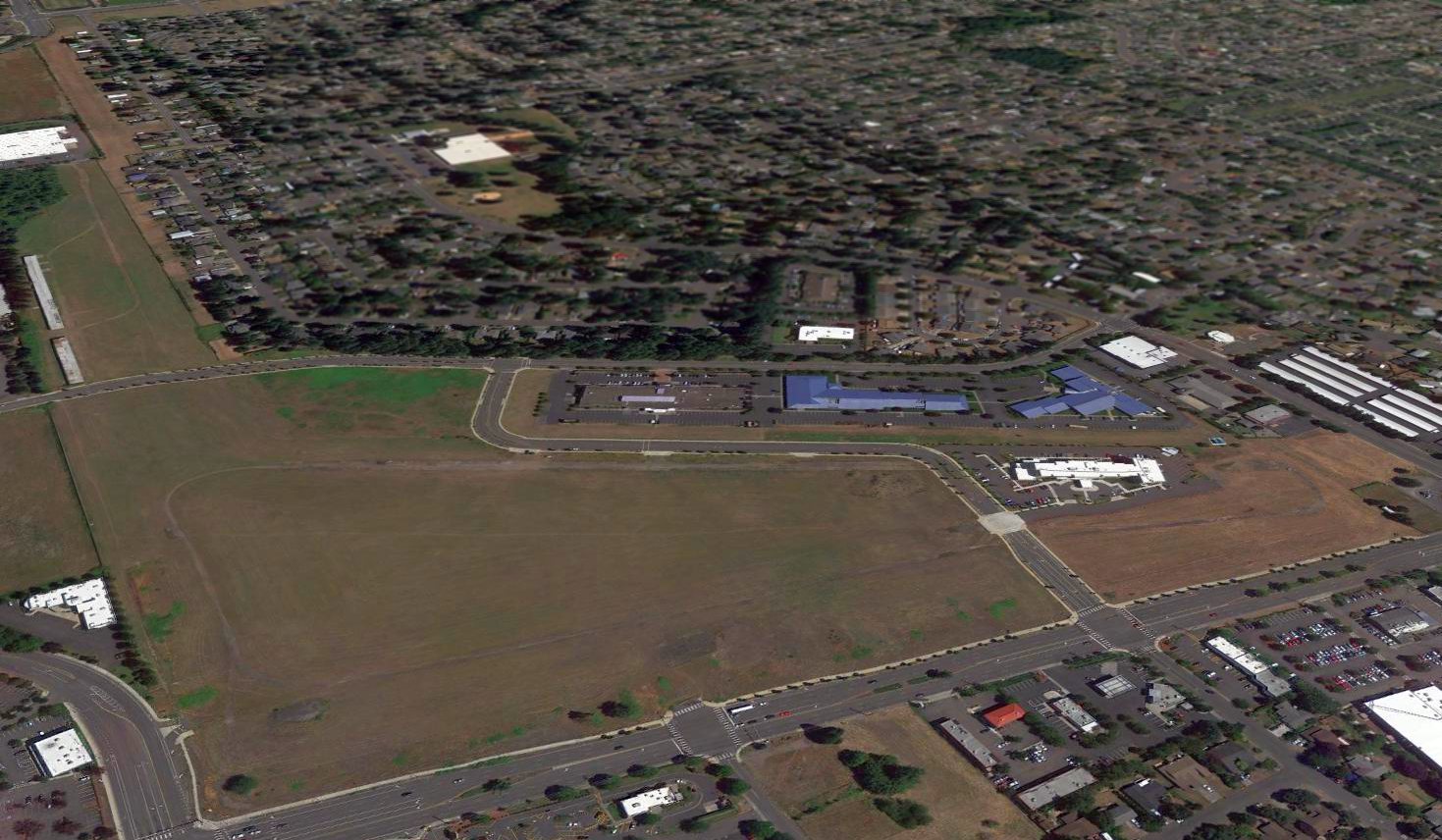
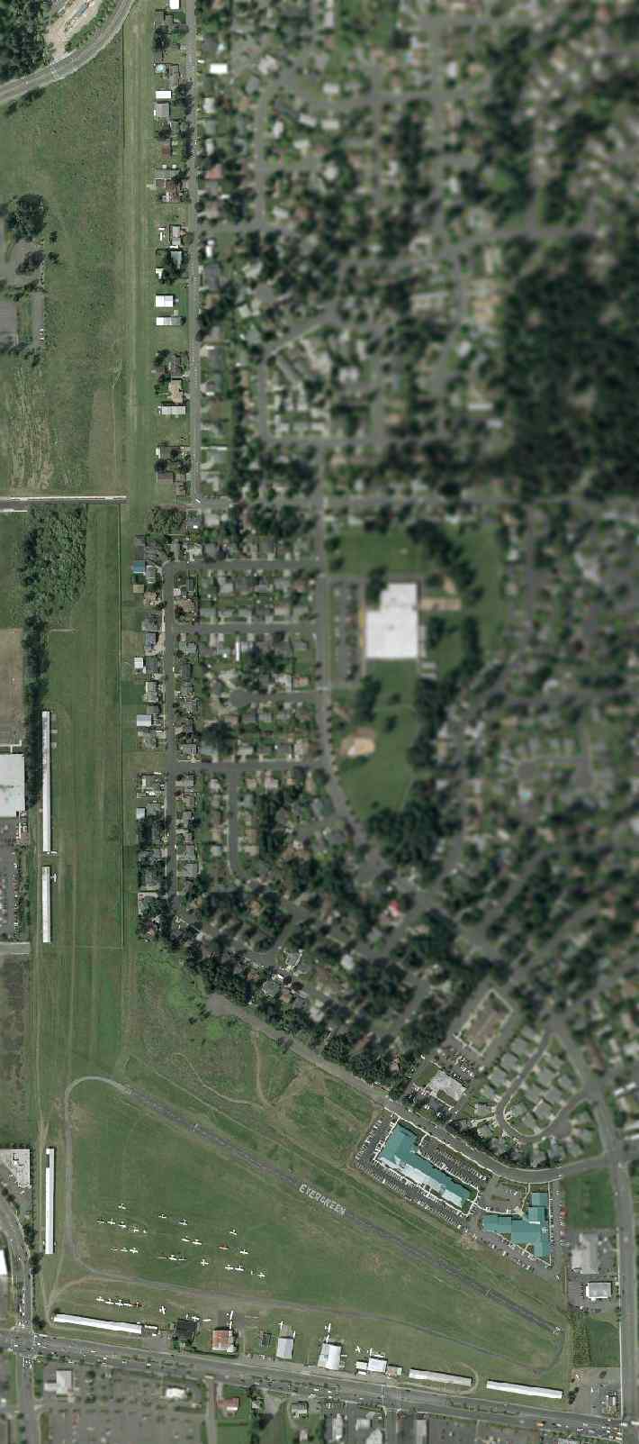
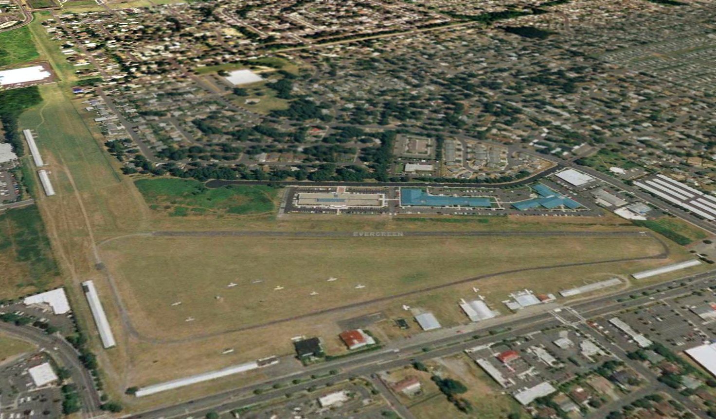
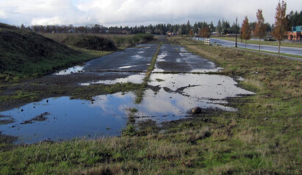
A 2016 aerial view looking northeast at the site of Evergreen Field, showing that a trace remains of its paved runway.
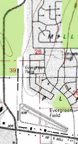
The 1,700' northern-most end of the north/south grass runway remains in use, as Evergreen North-South Airpark, a fly-in community.
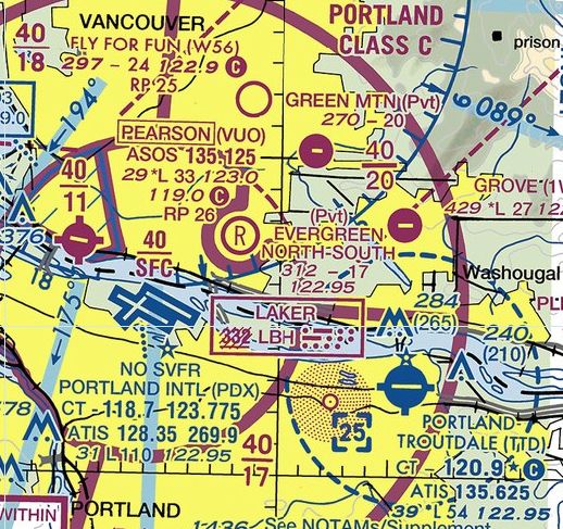
A de-scoped airfield continues on a portion of the Evergreen Field property,
as the December 2016 Seattle Sectional Chart depicts Evergreen North-South Airpark as a private airfield with a 1,700' unpaved runway.
Brian Visocky reported in 2017, “Evergreen Airport... the hangars on the old north/south grass runway were still being used even though a road was built thru it.
I rode my bike thru the area & there were still a couple of planes (Super Cubs & such) being hangared here as of a year ago.
I am sure they were not being used if at all even though the remaining grass field was big enough.
Note there is a fly-in community that is on the opposite side of the fence north-northeast to this field, still in operation, all that separated it was a chain link fence.”
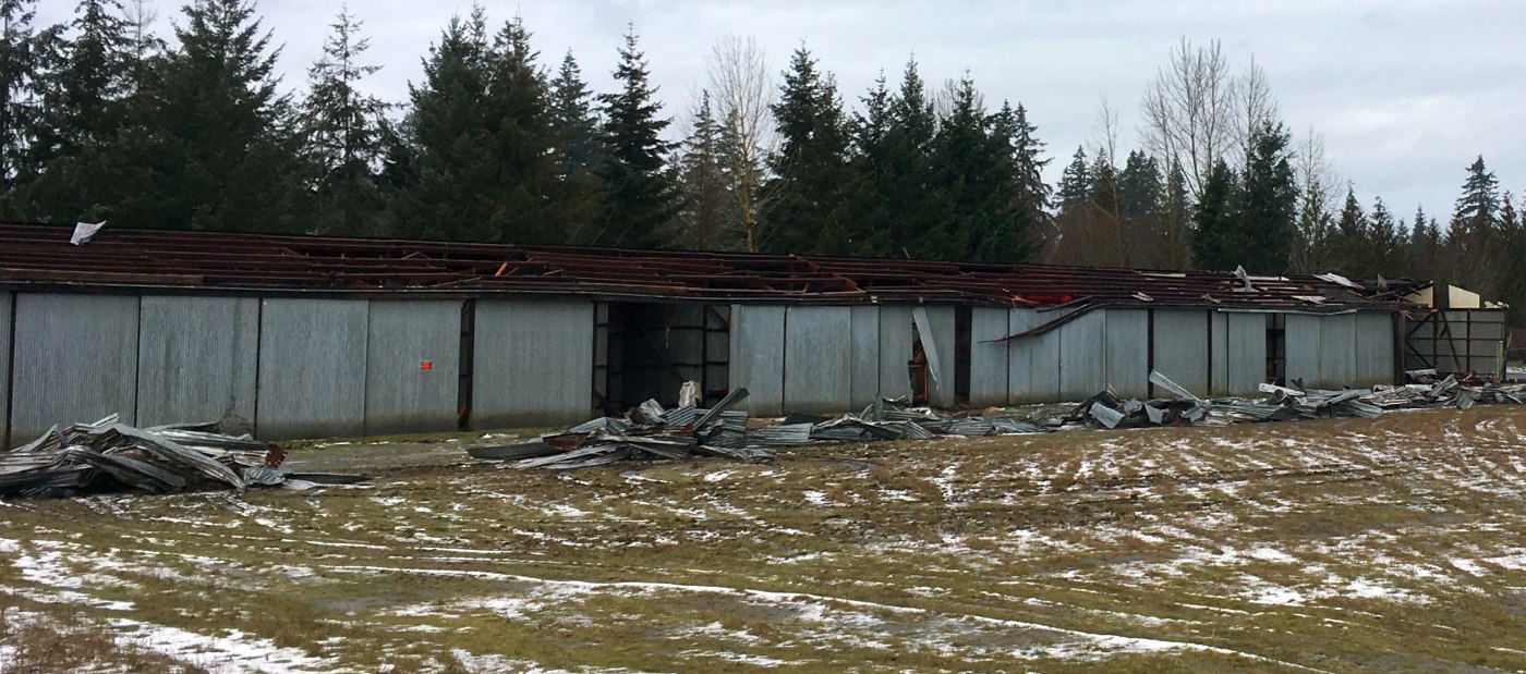
A 1/18/17 photo by Brian Viscoky looking northwest at the demolition of the hangars along the west side of the Evergreen Airpark site.
Brian reported, “They are now taking down the hangars. Sad to see them go. I love the smell of an old dirt floor metal hangar like these.”
A 1/18/17 photo by Brian Viscoky looking northwest at the hangars along the west side of the former Evergreen Airpark north/south grass runway.
A 5/2/17 photo by Ron Plante looking west at the runway numbers of the former Evergreen Field Runway 28, with a new hotel immediately behind it.
Ron Plante noted, “Development is rapidly covering the runway area, a retirement home is one of the bigger projects.
There is very little runway or taxiway left. Much to my surprise, behind the east side of the hotel is about 100' of Runway 28 with the numbers still visible.”
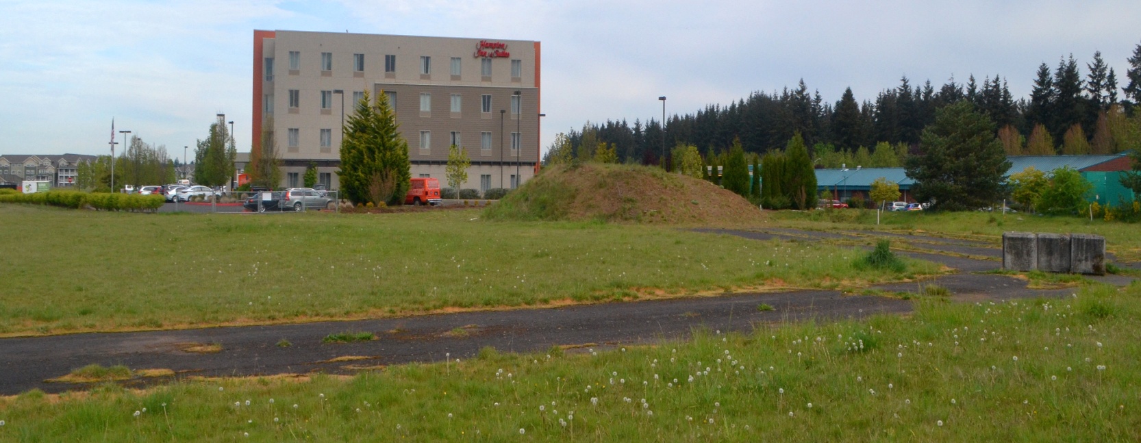
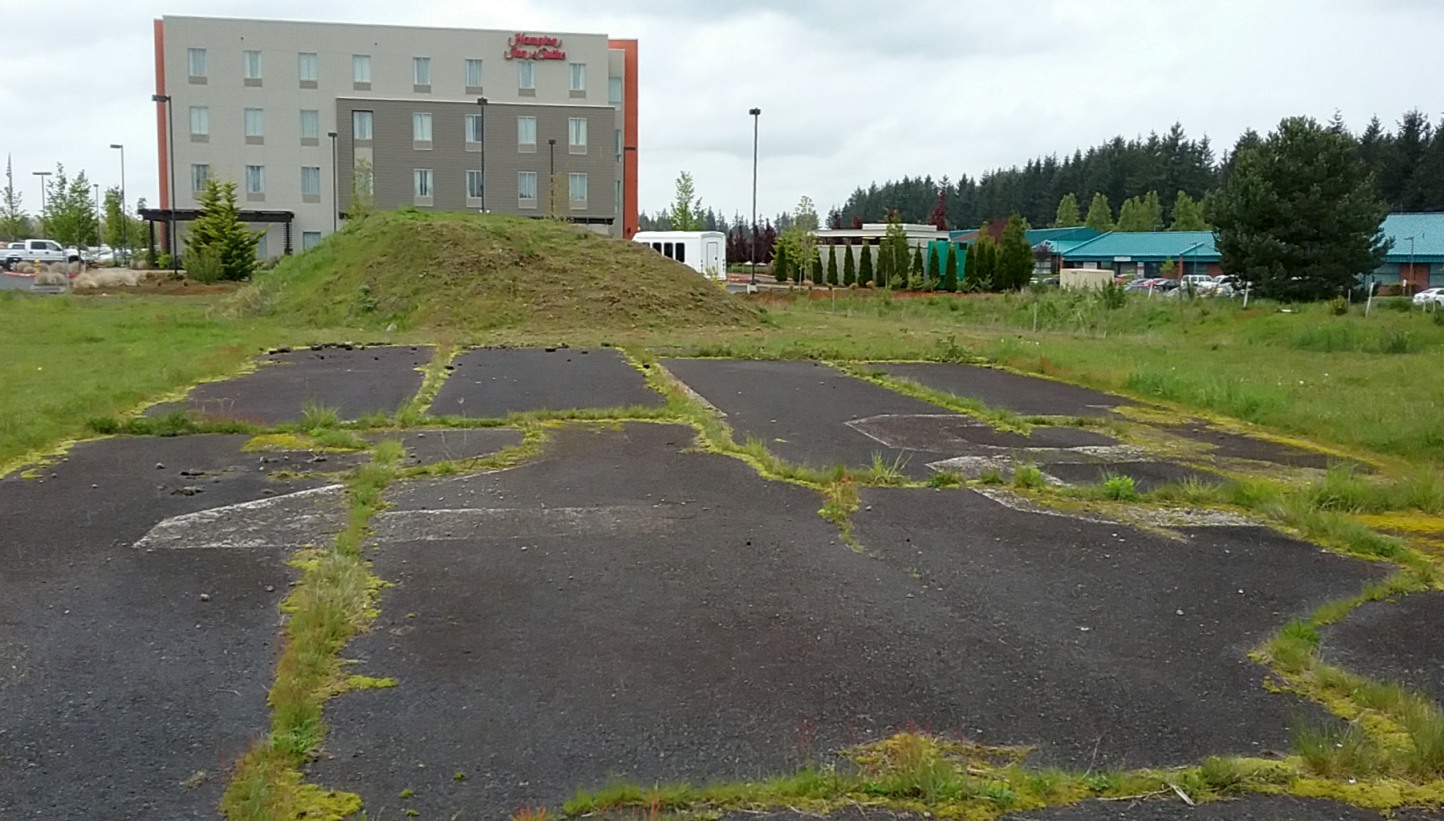
A 4/27/21 photo by Mark Morgan looking west at the remains of Evergreen Field runway pavement, with a Hampton Inn immediately behind it.
Mark reported, “A Hampton Inn occupies one portion of the former Evergreen Field. The property [is] now known as the mixed-use development 'The Landing.'”
Amazingly enough, some of the concrete survives at the extreme east end of the field, although the terrain there is now dominated by a vet's office & a new 7-11.”
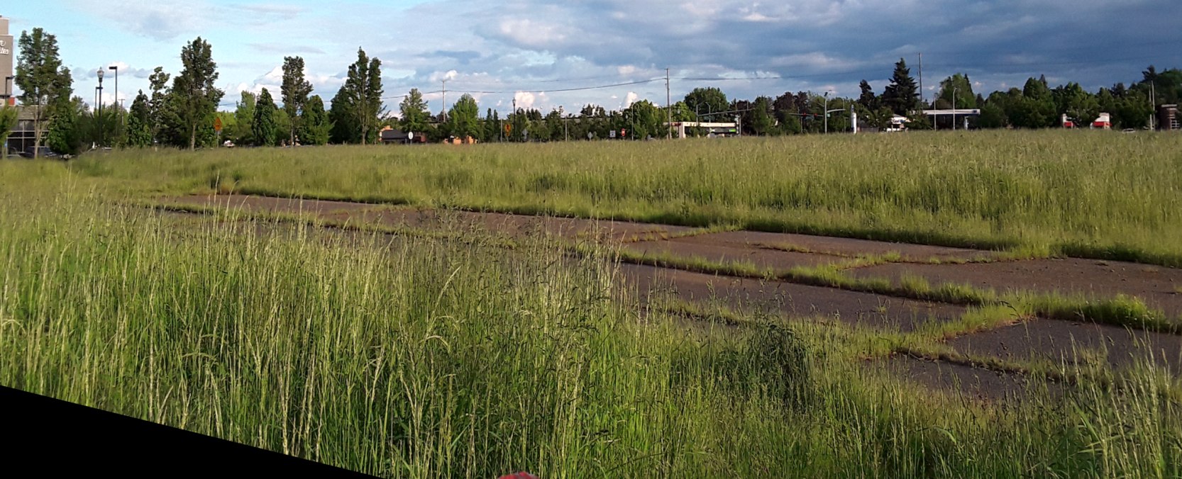
A 5/31/22 photo by Candy Jenkins looking southeast at the remains of the Evergreen Field runway pavement.
A 5/31/22 photo by Candy Jenkins looking west at the remains of the Evergreen Field runway pavement.
The site of Evergreen Field is located northeast of the intersection of Southeast Mill Plain Boulevard & Southeast 136th Avenue.
____________________________________________________
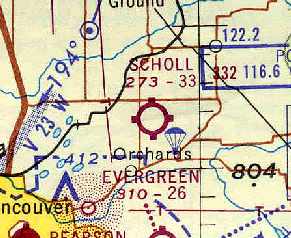
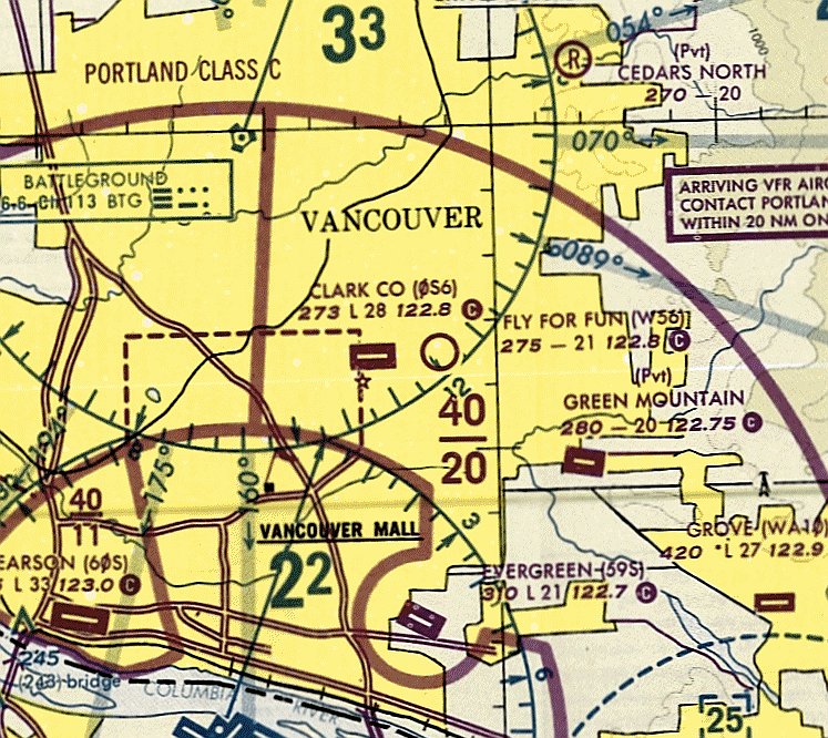
Scholl's Airport / Clark County Airport, Vancouver, WA
45.69, -122.545 (North of Portland, OR)
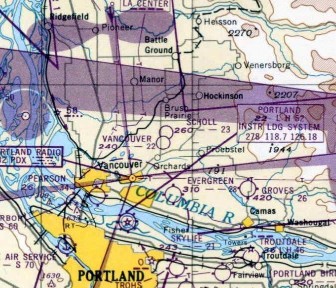
Scholl Airport, as depicted on the October 1949 Portland Sectional Chart.
This general aviation airport was apparently opened at some point between 1948-49,
as it was not depicted on the October 1948 Portland Sectional Chart (according to Chris Kennedy).
The earliest depiction of Scholl Airport which has been located was on the October 1949 Portland Sectional Chart.
It depicted Scholl as having a 2,300' unpaved runway.
Jeannie Yanko recalled, “I have so many wonderful memories of visiting my Uncle, Neil Scholl,
who had his home & airfield there when I visited beginning in the 1950s as a child.
He was always my favorite relative & I cherished the times my family visited him.
I used to wander all over that place and I even remember a turkey farm next door
where I got a great electric shock from the fence trying to get to them.”
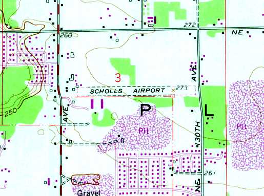
The earliest topo map depiction of Scholl Airport which has been located was on the 1954 USGS topo map.
It depicted Scholl as having a single east/west unpaved runway, with several buildings along the northwest & southwest sides.
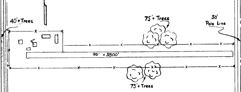
The 1963 WA Airport Directory (courtesy of Ron Dupas) depicted Scholl's Airport as having a single 3,800' turf east/west runway.
Five buildings (hangars?) were depicted on the northwest corner of the field.
The July 1969 Portland Sectional Chart (courtesy of Chris Kennedy) depicted "Scholl" as having a 3,300' unpaved runway.
An aerial view looking north at Scholl's Airport, from the 1971 WA Airport directory (courtesy of Chris Kennedy).
At least 7 light aircraft are visible on the west end of the field.
The 1971 WA Airport directory (courtesy of Chris Kennedy) depicted Scholl's Airport as having a single 3,300' turf Runway 7/25.
Several buildings or hangars were clustered around the west end of the runway, and a total of 7 light single-engine aircraft were visible on the field.
The manager was listed as Elvin Pluckett.
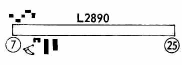
The 1972 Flight Guide (courtesy of Chris Kennedy) depicted Scholl's Airport as having a single 2,890' Runway 7/25.
Skydiving was listed as being conducted from the field.
Scholl's Airport was still listed as an active airfield in the 1976 AOPA Airport Directory (according to Chris Kennedy).
At some point between 1976-82 Scholl's Airport was evidently renamed Clark County Airport,
as that is how it was labeled on the January 1982 Seattle Sectional Chart (courtesy of Paul Columbus).
It depicted Clark County Airport as having a 2,800' paved east/west runway.
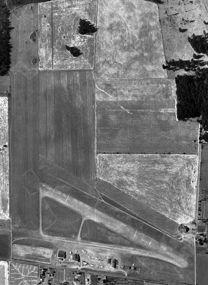
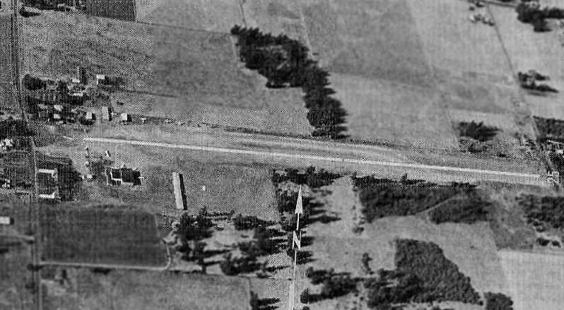
The last photo which has been located showing Scholl's / Clark County Airport still open was a 7/14/90 USGS aerial view looking northeast,
showing a dozen single-engine aircraft parked on the west side of the field.
Nearby resident Paul Feddema reported, "The airfield itself was fully functioning until 1992-93
when a new housing development went in on the east side of the airfield, across 130th Avenue (on the [east] side, going north & south)."
The last aeronautical chart depiction which has been located of Clark County Airport was on the January 1994 Seattle Sectional Chart (courtesy of Ron Plante).
It depicted Clark County Airport as having a 2,800' paved east/west runway.
The Clark County Airport runway was no longer depicted on the 1995 USGS topo map (although the former airfield buildings were still depicted).
Scholl's / Clark County Airport was no longer depicted on the June 1999 Seattle Sectional Chart (courtesy of Ron Plante).
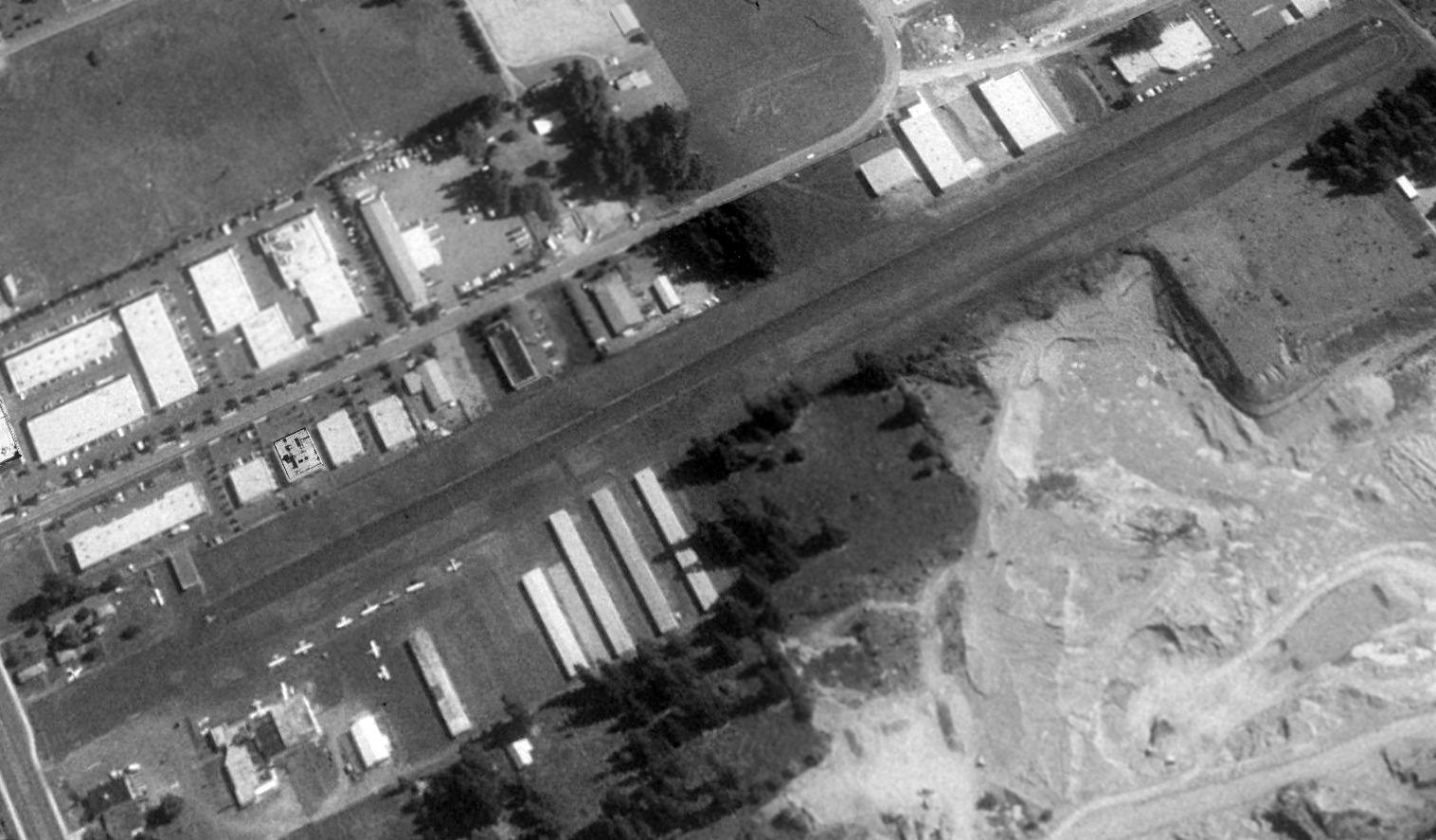
A 2000 USGS aerial photo showed the runway to remain intact at the site of Scholl's Airport,
with at least one closed-runway "X" symbol still visible in the middle of the runway.
Nearby resident Paul Feddema reported in 2004, "The building to the southeast of the strip is a Minit-Mart,
the building immediately to the southwest of that is the former Airport Inn
with connecting hangar to the northeast of it where fuel, flight lessons, and skydiving were all advertised.
The hangar no longer connects through the building & is a distribution point for some kind of plumbing supply place.
The Airport Inn itself was even renamed, when the strip closed, as Rumors.
The strip itself functions as an access road for several businesses
that bought up the hangar space cheap & converted for their own uses.
Until a few years ago, and maybe even still, the houses to the north of the airfield had their own private hangars
and I know of one that had a medium sized, all aluminum twin engine plane rotting in the backyard next to the former hangar.
It was weird considering the airfield had been closed for at least ten years by then."
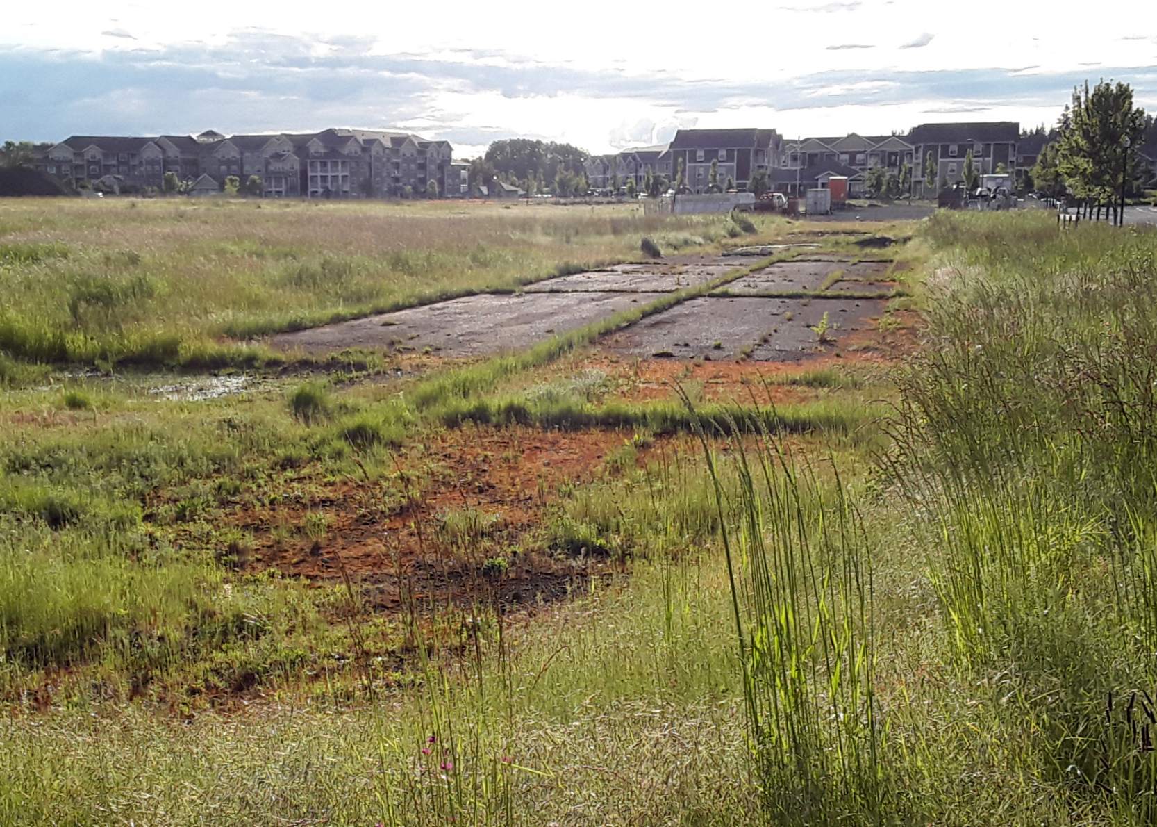
A 2005 aerial photo by Collin Gyenes looking east at the former runway of Scholl's Airport.
A circa 2007 aerial view looking west at the west end of the former runway of Scholl's Airport & the former hangar.
A 2018 aerial view looking northeast showed the majority of the former Scholl's Airport runway remained intact, although a building had been constructed over the east end.
Several former hangars remained standing on the southwest side.
A 2025 3-D aerial image looking southwest at the former Scholl's Airport hangar which remains on the southwest side.
The site of Scholl's Airport is located southeast of the intersection of Northeast 117th Avenue & Northeast 95th Street.
____________________________________________________
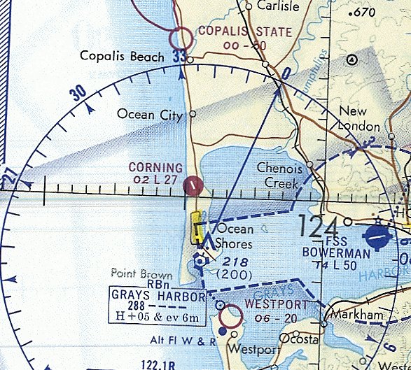
Ocean Shores Airport (original location) / Corning Field (S26), Ocean Shores, WA
47.005, -124.164 (Southwest of Seattle, WA)
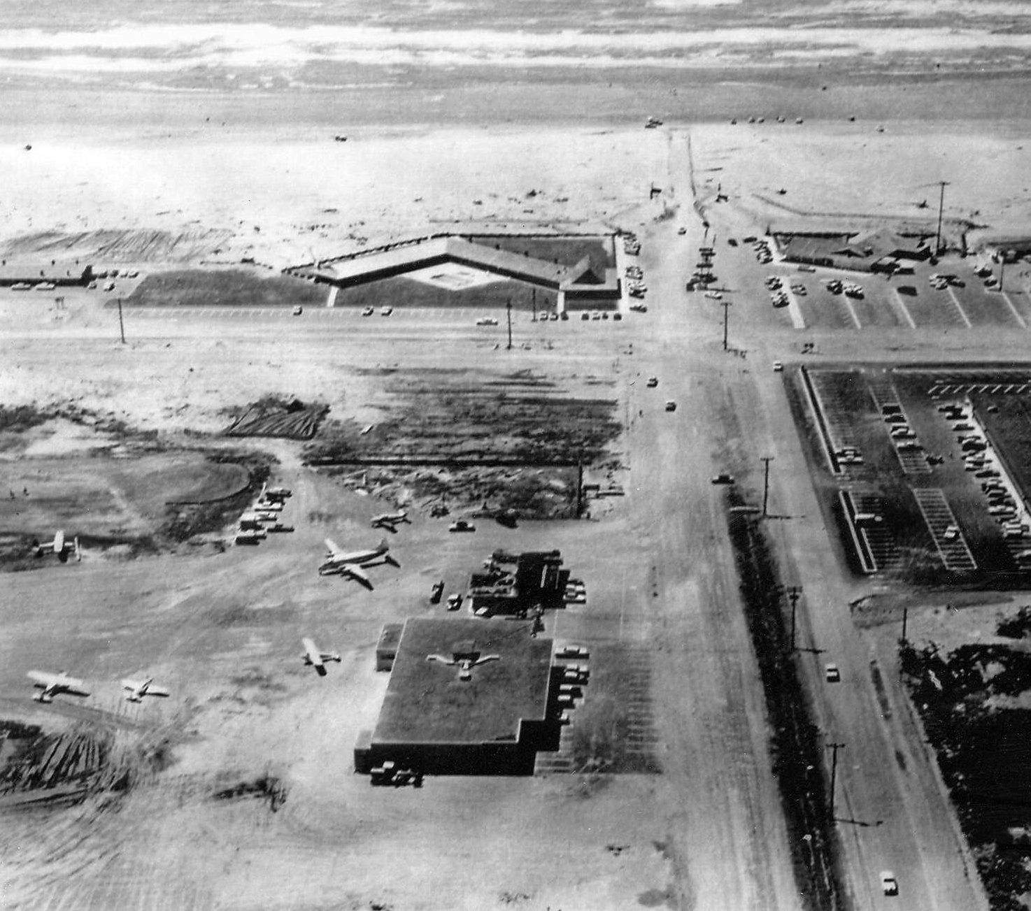
The earliest photo which has been located of Corning Field was an 11/2/67 aerial view looking west (courtesy of the Ocean Shores Public Library, via Lee Corbin).
This general aviation airport was located on a narrow peninsula along the Pacific Coast,
within a very small plot of land within the town of Ocean Shores.
The date of construction of Ocean Shores Municipal is unknown.
Ocean Shores Municipal Airport was not yet depicted on the 1955 USGS topo map or the October 1960 Seattle Sectional Chart.
The earliest depiction which has been located of Ocean Shores Municipal Aorport was a circa 1961-69 aerial view looking west (courtesy of the Ocean Shores Public Library, via Lee Corbin).
It depicted 5 planes parked on the north side, including a 4-engine De Havilland Dove airliner.
The earliest airport directory listing which has been located of Ocean Shores Airport was in the 1963 WA Airport Directory (courtesy of Ron Dupas).
It depicted Ocean Shores Airport as having a single 2,800' oiled northwest/southeast runway.
A bowling alley & a café were depicted immediately adjacent to the north end of the runway, but there were no hangars depicted.
A 1964 aerial view looking south (courtesy of the Ocean Shores Public Library, via Lee Corbin)
depicted Ocean Shores Airport as having an asphalt northwest/southeast runway, with 1 light plane parked on the northwest side.
There did not appear to be any hangars.
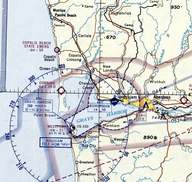
At some point between 1963-65, Ocean Shores Airport was apparently renamed to Corning Field,
as that is how it was labeled on the June 1965 Seattle Sectional Chart.
It depicted Corning Field as having a mere 1,900' unpaved runway.
An 11/2/67 aerial view looking east (courtesy of the Ocean Shores Public Library, via Lee Corbin) depicted Corning Field as having an asphalt Runway 14/32, with 1 light plane parked on the north side.
There did not appear to be any hangars.
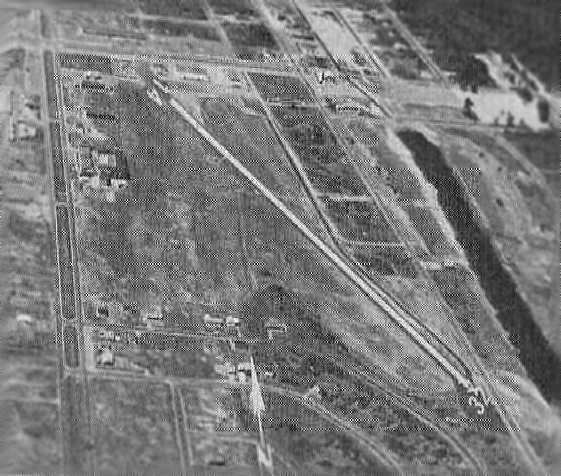
An aerial view looking north at Corning Field from the 1971 WA Airport directory (courtesy of Chris Kennedy).
The July 1971 Seattle Sectional Chart (courtesy of Ron Plante) showing Corning Field
has been gained a paved 2,700' runway at some point between 1967-71.
A 9/19/71 USGS aerial view depicted Corning Field as having an asphalt Runway 14/32, with a few small buildings & possibly some light aircraft on the north side.
The 1973 USGS too map depicted Corning Field as having a single northwest/southeast runway, labeled simply as “Landing Strip”.
At some point between 1971-82, Corning Field was renamed to Ocean Shores Municipal Airport,
as that is how it was listed in the 1982 AOPA Airport Directory (courtesy of Ed Drury).
It was described as having a single 2,050' asphalt Runway 14/32, and the operator was listed as Oceanaire.
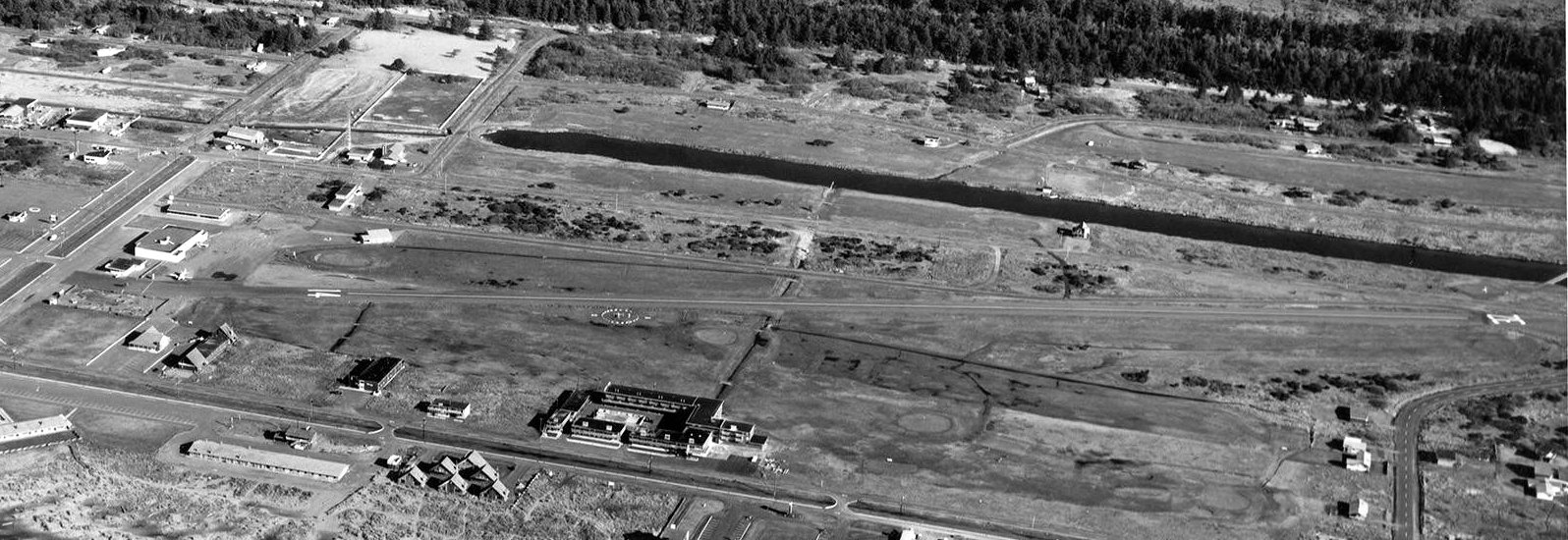
The last photo which has been located of the original Ocean Shores Airport was an 8/4/83 aerial view.
It depicted the field as having an asphalt Runway 14/32, with 4 light aircraft parked among several small buildings on the north side.
Karl Brohan “I have an interesting story about landing a CH-47A Chinook at Ocean Shores Airport in 1985.
It was a nice summer drill weekend in 1985. The C.O. of the 92nd Transportation Company, Medium Helicopter, based at Paine Field, wanted all available crews out flying.
We had to use up our fuel allotment or it would be reduced the following year. I was the Pilot In Command & I chose Lt. Jackie Reeves as my copilot.
We headed out to Ocean Shores on a magnificent sunny day. There was little wind as we made our approach & landing to the field which was very close to a golf course.
The parking checklist was in progress when the crew chief noticed a parent holding up a child so he could touch a slow moving rotor blade as it wound down!
The crew chief jumped out & directed the parent & the crowd forming around the aircraft to move back until the rotors had stopped.
Myself & the crew had lunch & returned to the aircraft about 45 minutes later to find the same crowd had set up lawn chairs under the rotors so they could watch the takeoff.
I explained that everyone must move away from the aircraft because of the danger from the rotors & possible flying debris from the rotors downwash.
The spectators moved back about 40' & wouldn’t budge any further.
We started up & decided a vertical takeoff was the safest departure so we wouldn’t fly directly over any people.
I pulled pitch with a slow turning vertical departure. The crew chief advised that the spectators in the lawn chairs were blown across the lawn!
I didn’t get to see that since I was scanning the area for other aircraft.”
Bob Bernsetin recalled, "I happen to have flown Skyhawks
during the period when Ocean Shores Municipal was still located in its original location."
He reported that in its later years, Ocean Shores Municipal Airport coexisted in close proximity with a golf course.
"In 1986, my last flight to Ocean Shores Municipal, the golf course was in operation already.
You landed amidst golfers whacking away.
Landing wasn't as much an issue as you might expect because the strip was at right angles to the coast
making the strong prevailing winds off the ocean the primary concern in my mind.
It would blow so hard as to make landings impossible on several attempts.
Finally making it in, the golfers were in my mind only as an afterthought.
Takeoff, on the other hand, was an entirely different matter.
I remember just at the point of roll crossing my fingers,
with a brief imagined moment of the golf ball striking my prop halfway down the runway.
Of course it didn't happen, and my trip home to Boeing field was as joyful as the rest of my flying career."
The location of this airfield, within the town of Ocean Shores, was apparently the reason why it was replaced in 1986
by a new Ocean Shores Municipal Airport located at a less constrained site a mile to the east.
Bob Bernsetin recalled, "Imagine my surprise on a later vacation trip to Ocean Shores.
On a lark, I decided to visit the airport again, and only found a golf course!
I kept ignoring signs to the airport, that were obviously a mistake, as I knew the airport had to be 'right here'!
Finally I went over to the new airport & saw it was indeed in a different place than I remembered.
I started to really wonder until I found evidence on the Internet of the decision to move the airport,
apparently very soon after I flew there."
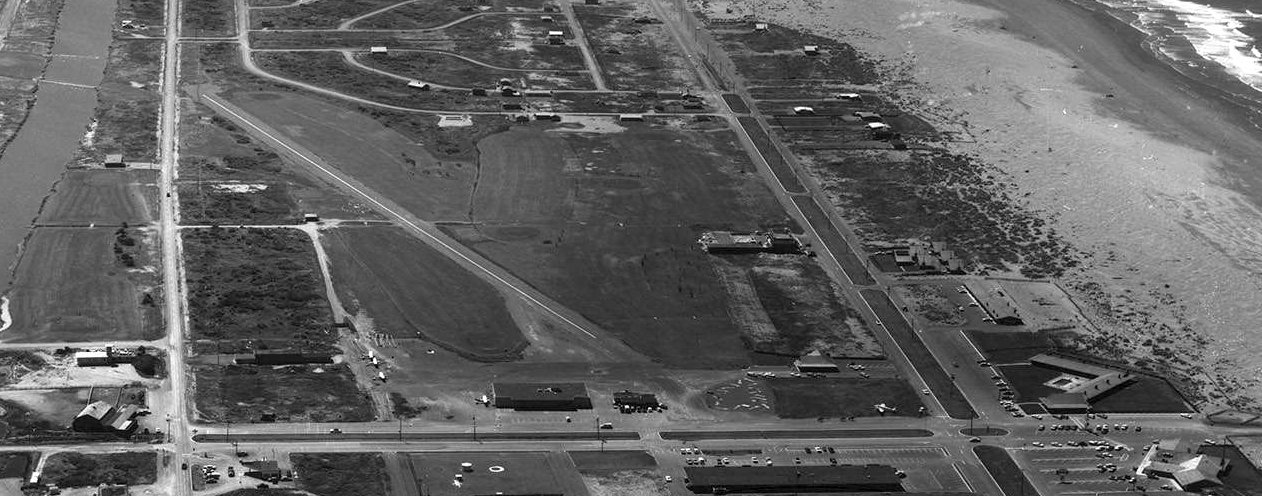
By the time of the 1990 USGS aerial photo, the site of the original Ocean Shores Airport had been completely covered with a golf course,
but the former runway outline (oriented northwest/southeast) was still recognizable.
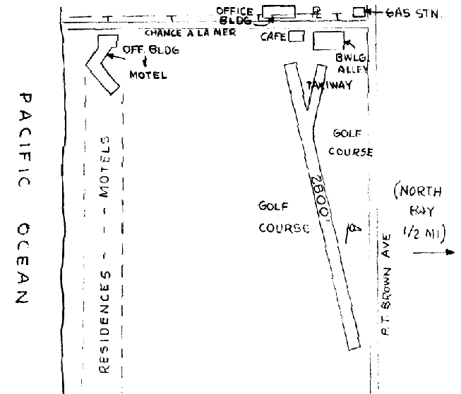
The site of the original Ocean Shores Airport is bounded by Ocean Shores Boulevard on the west, Chance A La Mer on the north,
Minard Avenue on the east, and Ensign Avenue on the south.
Thanks to Glenn Powell for pointing out this airport.
____________________________________________________
Or if you prefer to contact me directly concerning a contribution (for a mailing address to send a check),
please contact me at: paulandterryfreeman@gmail.com
If you enjoy this web site, please support it with a financial contribution.
____________________________________________________
This site covers airfields in all 50 states.