Abandoned & Little-Known Airfields:
Southern Texas
© 2002, © 2026 by Paul Freeman. Revised 4/10/26.
This site covers airfields in all 50 states: Click here for the site's main menu.
____________________________________________________
Please consider a financial contribution to support the continued growth & operation of this site.
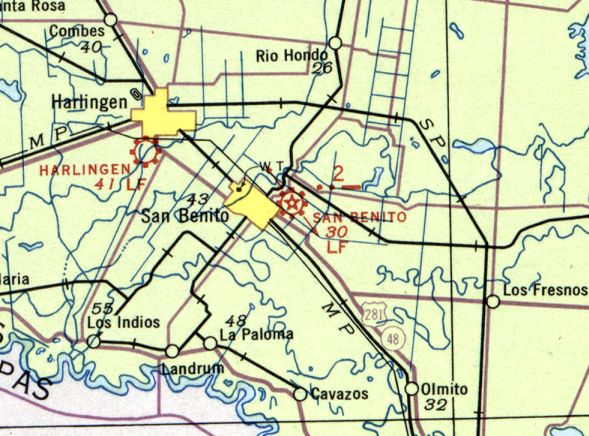
Edinburg Municipal (revised 6/11/18) - Esperanza Ranch Airfield (added 2/24/25) - Falcon State Park Airfield (revised 5/4/22) - Fox Airport (added 12/24/19) - Harlingen Airport (original location) (added 4/10/26)
Harlingen Municipal Airport / Harvey Richards Field (revised 7/25/23) - Humble Kelsey Airfield (added 3/28/20) - Mauldin Airport (revised 5/7/17)
Moore Aux AAF #2 / Mission Field / Arrowhead Ranch Airfield (revised 1/3/17) - Moore Aux AAF #3 / Rio Grande Field (revised 11/21/19) - San Benito Municipal (revised 7/27/23)
____________________________________________________
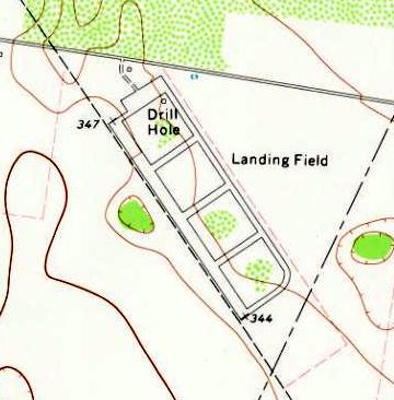
Esperanza Ranch Airfield, Yturria, TX
26.565, -97.784 (Southeast of San Antonio, TX)
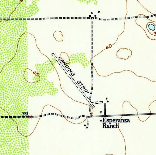
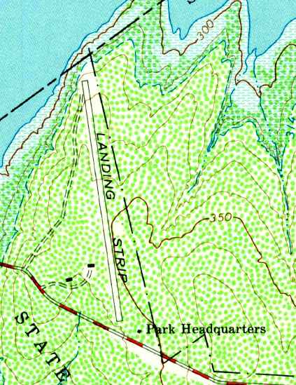
Esperanza Ranch Airfield, as depicted on the 1958 USGS topo map.
This rural ranch airfield was evidently established at some point between 1953-58, as it was not yet depicted on a 1953 aerial photo.
The earliest depiction which has been located of Esperanza Ranch Airfield was on the 1958 USGS topo map.
It depicted a single unpaved northwest/southeast runway, labeled generically “Landing Strip”, with the buildings of Esperanza Ranch to the southeast.
No airfield was depicted at this location on the August 1958 Corpus Christi Sectional Chart (or subsequent Sectional Charts), just several ranches.
The earliest photo which has been located of Esperanza Ranch Airfield was a 1960 aerial view.
It depicted a single unpaved northwest/southeast runway, with the buildings of Esperanza Ranch to the southeast.
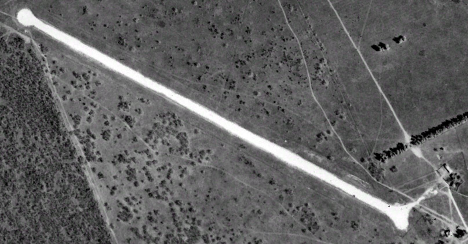
The earliest photo which is available of Esperanza Ranch Airfield was a 1961 aerial view looking northeast.
It depicted a single unpaved northwest/southeast runway, with the buildings of Esperanza Ranch to the southeast, but no aircraft were visible on the field.
The 1992 USGS topo map depicted Esperanza Ranch Airfield as a single northwest/southeast runway, labeled generically “Landing Strip”.
A 2023 aerial view looking northeast depicted the remains of the Esperanza Ranch Airfield runway remained recognizable.
Thanks to Sebastian Nielsen for pointing out this airfield.
____________________________________________________
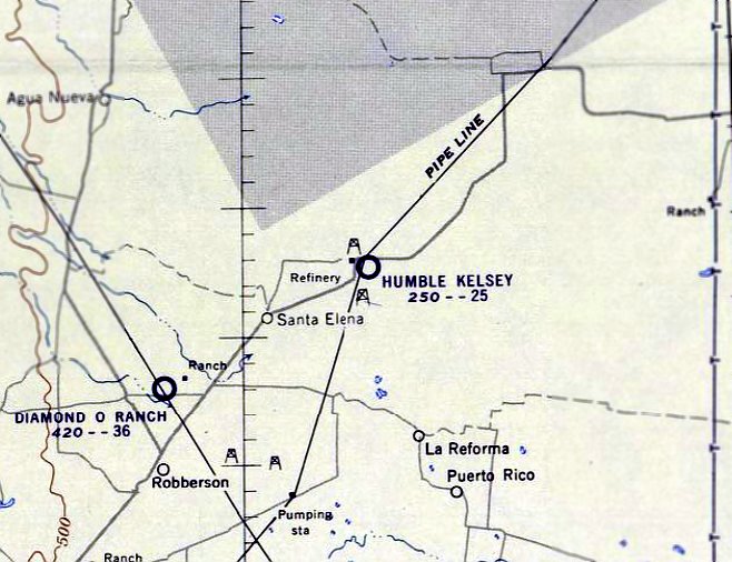
Humble Kelsey Airfield, Santa Elena, TX
26.792, -98.416 (South of San Antonio, TX)
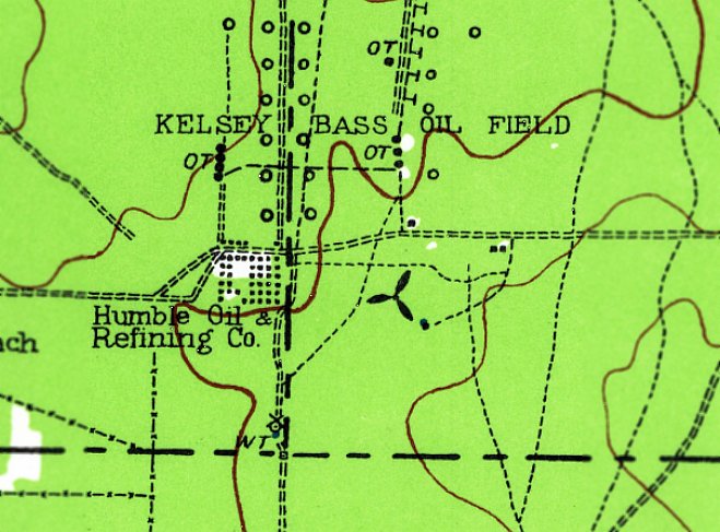
Humble Kelsey Airfield, as depicted (with the airplane propeller symbol) on the 1939 USGS topo map.
The date of establishment of this early private airfield in a very remote section of Southern Texas has not been determined.
The earliest depiction which has been located of Humble Kelsey Airfield was on the 1939 USGS topo map.
It did not depict any aspect of the airfield's configuration, just a airplane propeller symbol.
Humble Kelsey Airfield was not depicted on Corpus Christi Sectional Charts from 1939-47.
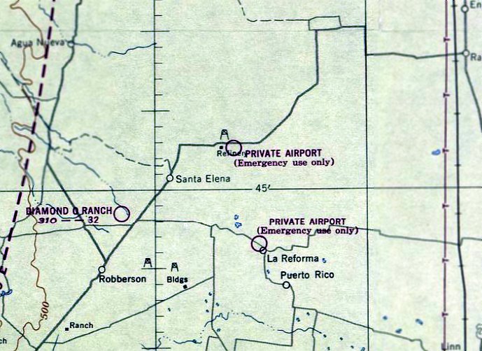
The earliest aeronautical chart depiction which has been located of Humble Kelsey Airfield was on the July 1948 Corpus Christi Sectional Chart.
It depicted it simply as “Private Airport (Emergency use only)”.
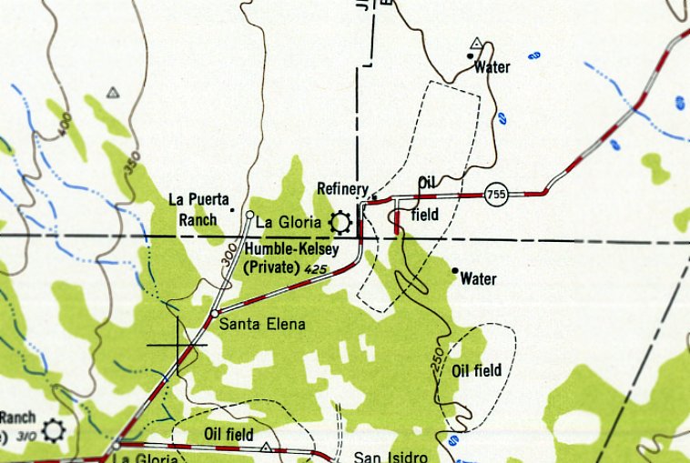
The 1949 USGS topo map depicted “Humble-Kelsey (Private)” Airfield on the opposite (west) side of Route 755,
which was most likely erroneous.
The 1957 USGS topo map once again depicted “Humble Kelsey” Airfield on the correct (east) side of Route 755.
The last aeronautical chart depiction which has been located of Humble Kelsey Airfield was on the August 1957 Corpus Christi Sectional Chart.
It depicted Humble Kelsey Airfield as having a 2,500' unpaved runway.
Humble Kelsey Airfield was evidently closed (for reasons unknown) at some point between 1957-58,
as it was no longer depicted on the August 1958 Corpus Christi Sectional Chart.
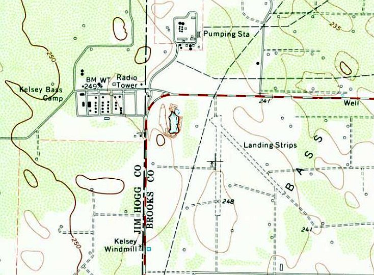
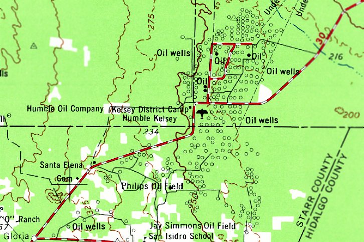
The 1972 USGS topo map depicted Humble Kelsey Airfield as 2 unpaved runways, labeled generically as “Landing Strips”.
The earliest photo which has been located of Humble Kelsey Airfield was a 1993 USGS aerial view looking east.
It depicted 2 unpaved runways, with numerous cleared pads around the runways (possibly oil wells).
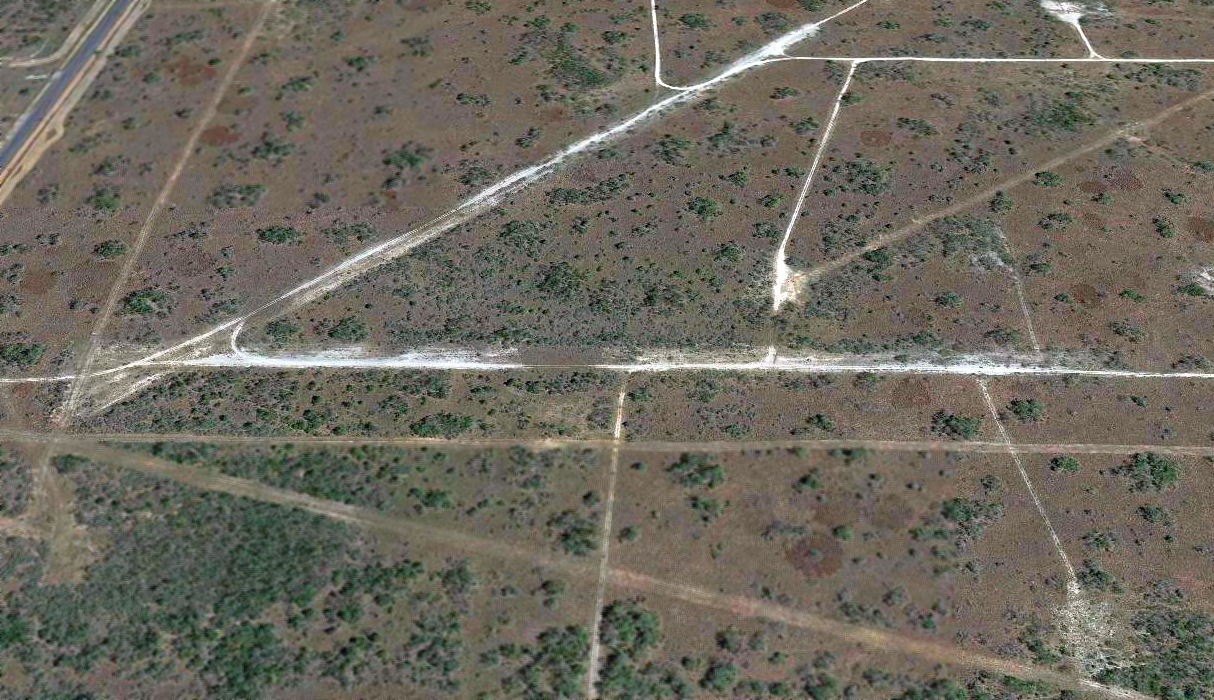
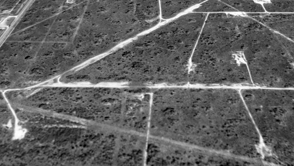
A 2019 aerial view looking east depicted Humble Kelsey Airfield as having 2 unpaved runways, deteriorated but still recognizable.
Thanks to Stewart Lanham for pointing out this airfield.
____________________________________________________
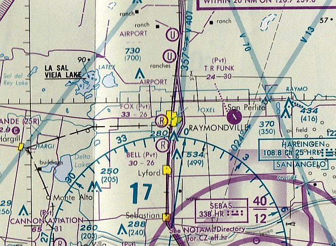
Fox Airport, Raymondville, TX
26.473, -97.791 (Southwest of Corpus Christi, TX)
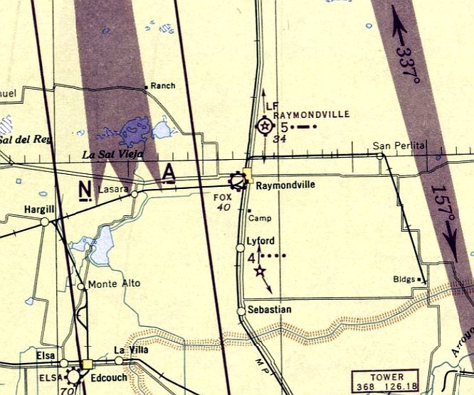
Fox Airport, as depicted on the January 1946 Corpus Christi Sectional Chart.
This small general aviation airport was evidently established at some point between 1945-46,
like hundreds of other small American airports established in the immediate post-WW2 general aviation boom.
Fox Airport was not yet depicted on the July 1945 Corpus Christi Sectional Chart.
The earliest depiction which has been located of Fox Airport was on the January 1946 Corpus Christi Sectional Chart,
which depicted Fox Airport as a commercial/municipal airport.
The earliest photo which has been located of Fox Airport a 1949 TX General Land Office aerial photo (courtesy of Lee Corbin).
It depicted Fox Airport as having 4 light single-engine general aviation aircraft parked near a hangar on the northeast side of an unpaved airfield.
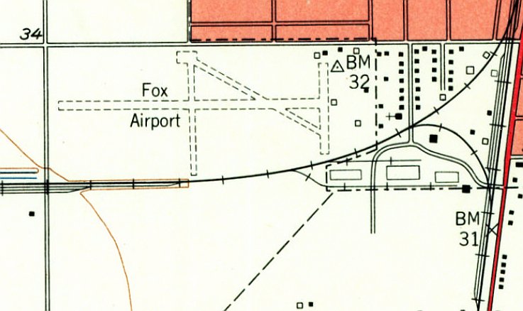
The 1956 USGS topo map (courtesy of Lee Corbin) depicted Fox Airport as having 3 unpaved runways, with several small buildings on the northeast side.
A 1961 TX General Land Office aerial photo (courtesy of Lee Corbin) depicted Fox Airport as remaining intact,
but there were no aircraft visible on the field.
The 1970 USGS topo map depicted Fox Airport in the same fashion as the 1956 topo map.
The 1984 USGS topo map no longer depicted Fox Airport.
The last aeronautical chart depiction which has been located of Fox Airport was on the June 1993 Brownsville Sectional Chart (courtesy of Ron Plante).
It depicted Fox Airport as a private airfield having a 2,600' unpaved runway.
Fox Airport was evidently closed (for reasons unknown) at some point between 1993-2009,
as it was no longer depicted on the 2009 Brownsville Sectional Chart.
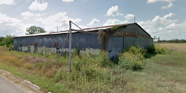
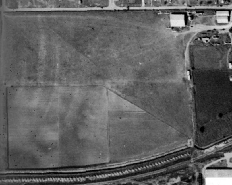
A 2011 photo looking southeast (courtesy of Lee Corbin) depicted the hangar at the northeast corner of the Fox Airport site as remaining intact.
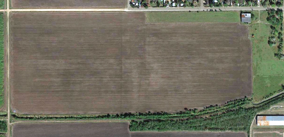
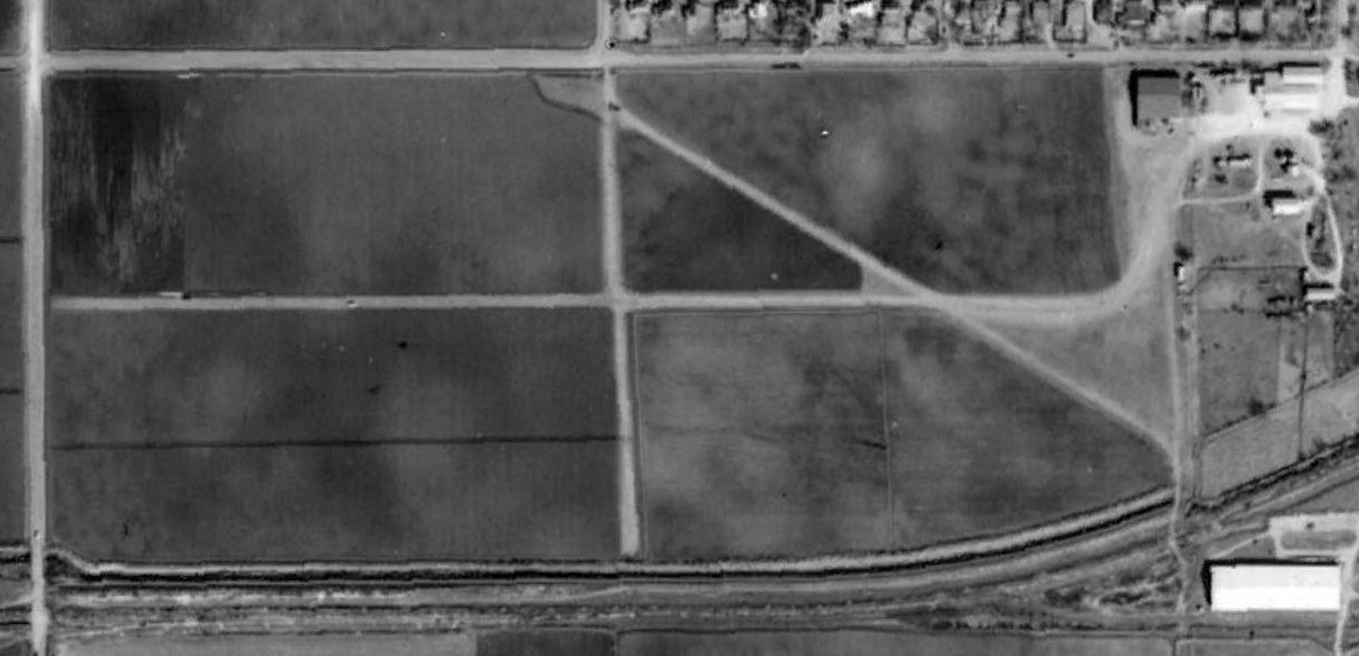
A 2017 aerial view showed the site of Fox Airport has been returned to cultivation, but the hangar at the northeast corner remains standing.
Thanks to Lee Corbin for pointing out this airfield.
____________________________________________________
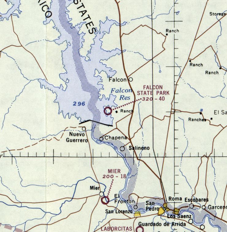
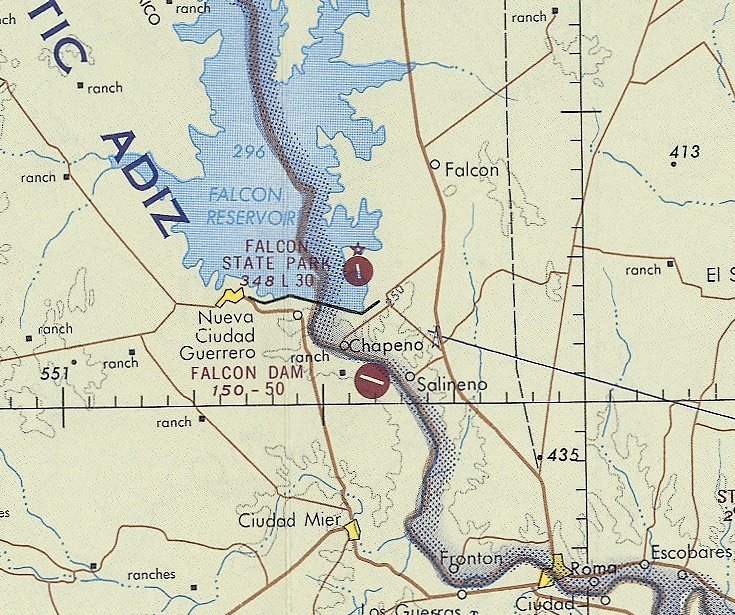
Falcon State Park Airfield, Falcon Heights, TX
26.585, -99.14 (Southwest of Corpus Christi, TX)
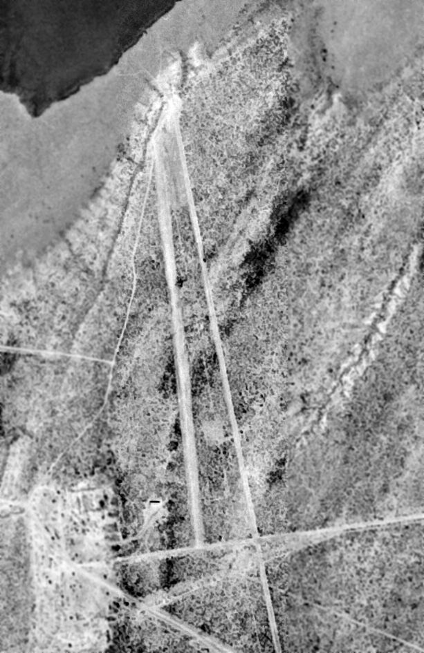
A 2/26/64 USGS aerial view of the Falcon State Park Airfield.
This airfield is located a mere 2 miles from the Mexican border, adjacent to the shore of Falcon Lake.
The purpose of the airfield has not been determined.
Falcon State Park Airfield was evidently established at some point in 1964,
as it was not yet depicted on the 1962 USGS topo map nor on the 1964 Corpus Christi Sectional Chart.
The earliest depiction of Falcon State Park Airfield which has been located was a 2/26/64 USGS aerial view,
which depicted a single northwest/southeast runway with one small building on the southwest side.
The 1965 USGS topo map depicted Falcon State Park Airfield as a single northwest/southeast runway, labeled “Landing Strip”.
Falcon State Park Airfield was still not depicted on the February 1965 Corpus Christi Sectional Chart.
The earliest aeronautical chart depiction which has been located of Falcon State Park Airfield was on the July 1965 Corpus Christi Sectional Chart,
which depicted Falcon State Park Airfield as having a 4,000' unpaved runway.
Falcon State Park Airfield had evidently gained a paved runway at some point between 1965-68,
as the ebruary 1968 Corpus Christi Sectional Chart depicted it as having a single 3,000' paved northeast/southwest runway.
The last aeronautical chart depiction which has been located of Falcon State Park Airfield was on the January 1972 Corpus Christi Sectional Chart (courtesy of Ron Plante).
It depicted Falcon State Park Airfield as having a single 3,000' paved northeast/southwest runway.
The 1980 USGS topo map depicted Falcon State Park Airfield in the same fashion as the 1965 topo map.
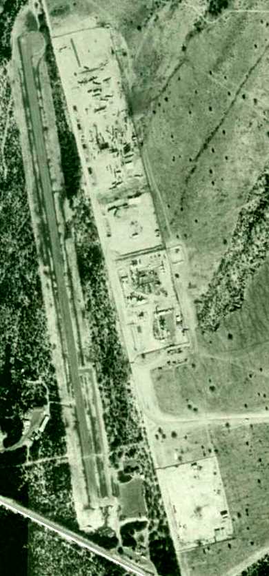
A 1995 USGS aerial view depicted Falcon State Park Airfield as having a single paved north/south runway,
along with a paved ramp on the southeast side.
A 4/8/08 aerial view looking north appeared to show Falcon State Park runway as remaining intact,
with several trailers parked along the southern portion (perhaps to impede illicit use of the strip).
Falcon State Park Airfield was depicted as an abandoned airfield on the August 2020 Brownsville Sectional Chart.
The site of Falcon State Park Airport is located northwest of the intersection of Highway 77 & McAllen Road.
____________________________________________________
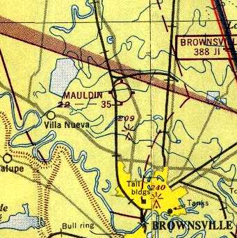
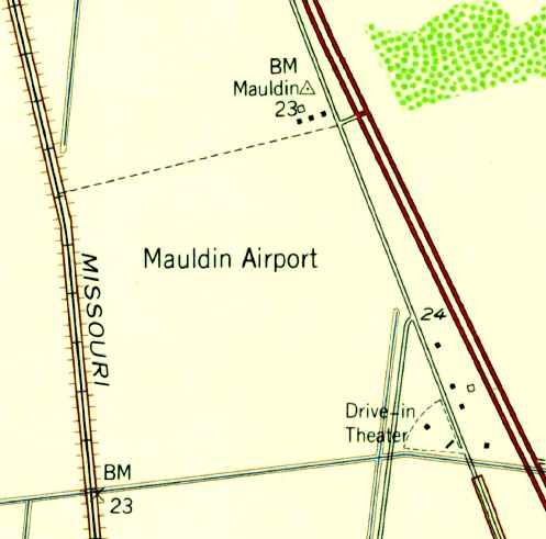
Mauldin Airport, Brownsville, TX
25.969, -97.516 (Southwest of Corpus Christi, TX)
Mauldin Airport, as depicted on the June 1941 Corpus Christi Sectional Chart.
Mauldin Airport was apparently built at some point between 1939-41,
as it was not yet depicted on the February 1939 Corpus Christi Sectional Chart.
The earliest depiction of Mauldin Airport which has been located was on the June 1941 Corpus Christi Sectional Chart,
which depicted it as a commercial/municipal airport.
According to the book "70 Years of Airport History in Brownsville" (courtesy of Steve Cruse),
Les Mauldin was an early manager of the Brownsville Municipal Airport.
By the 1940s, Mauldin was operating his own airport, north of the town.
According to Steve Cruse, his uncle soloed at Mauldin Airport in 1942.
The 1944 US Army/Navy Directory of Airfields (courtesy of Ken Mercer)
described Mauldin Airport as having a 2,200' unpaved runway.
According to the book "The First 70 Years - A History of Higher Education in Brownsville" (courtesy of Steve Cruse),
In the early 1940s, a civilian pilot training course was offered by Brownsville Junior College,
with the flying conducted at Mauldin Airport.
In 1941, night classes were offered to train young men in preparation for entering the Army Air Corps.
The 1947 Brownsville Local Aeronautical Chart (courtesy of Steve Cruse)
depicted Mauldin as a commercial airport, having a 3,500' unpaved runway.
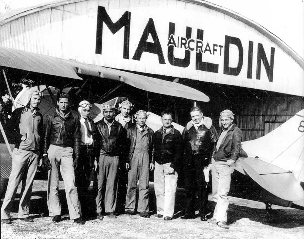
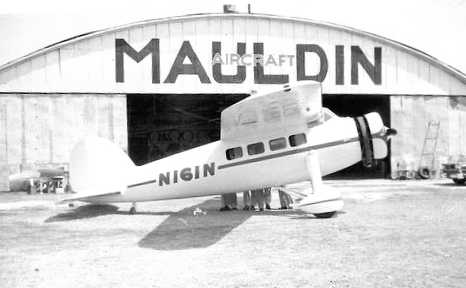
The earliest photo which has been located of Mauldin Airport was a circa 1940s photo (courtesy of Stan Amyett)
of Richard Eckert (the shortest man in the middle) & a group in front of a biplane & a “Mauldin Aircraft” hangar.
Stan Amyett would be interested in hearing from anyone who knows anything about the picture or the people pictured.
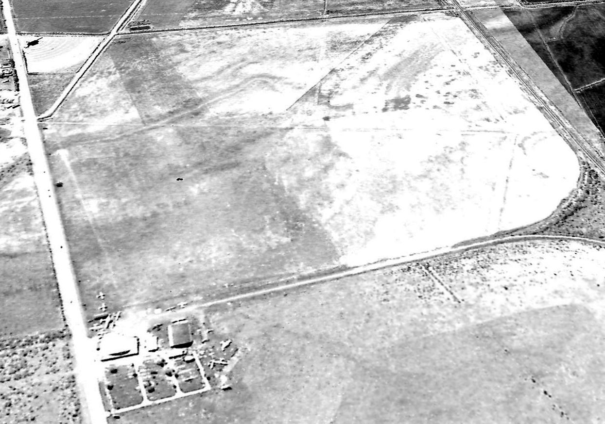
The earliest aerial photo which has been located of Mauldin Airport was a 1949 aerial view looking south.
It depicted Mauldin Field as as having 3 turf runways, with several buildings & a dozen aircraft on the northeast side.
The 1956 USGS topo map depicted Mauldin Airport simply as an open area with 3 small buildings along the northeast corner.
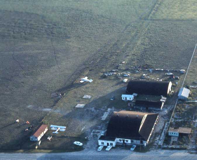
A circa 1960-61 aerial view by Tom Kramer looking west at Mauldin's hangars,
with a biplane & a low-wing monoplane parked outside.
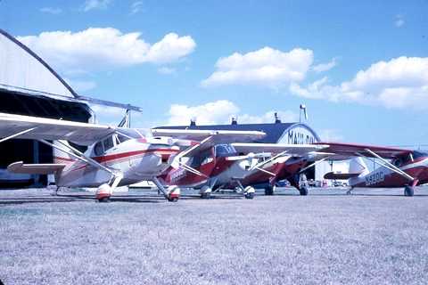
A circa 1960-61 photo by Tom Kramer of planes at Mauldin Airport.
A circa 1960-61 photo by Tom Kramer “of a Lockheed Vega that Les Mauldin & some of the boys from Harlingen AFB
restored just in time for an air show at the Air Base.
Unfortunately the Vega crashed & burned minutes after takeoff. No one was injured because Les Mauldin was at the controls.”
The 1962 AOPA Airport Directory described Mauldin Airport as having 3 sod runways, with the longest being the 3,850' Runway 4/22.
The operator was listed as Maulidn Aircraft Inc.
A 1962 aerial view depicted Mauldin Field as as having 3 turf runways.
Several buildings were depicted at the northeast corner of the field, around which were parked several light aircraft.
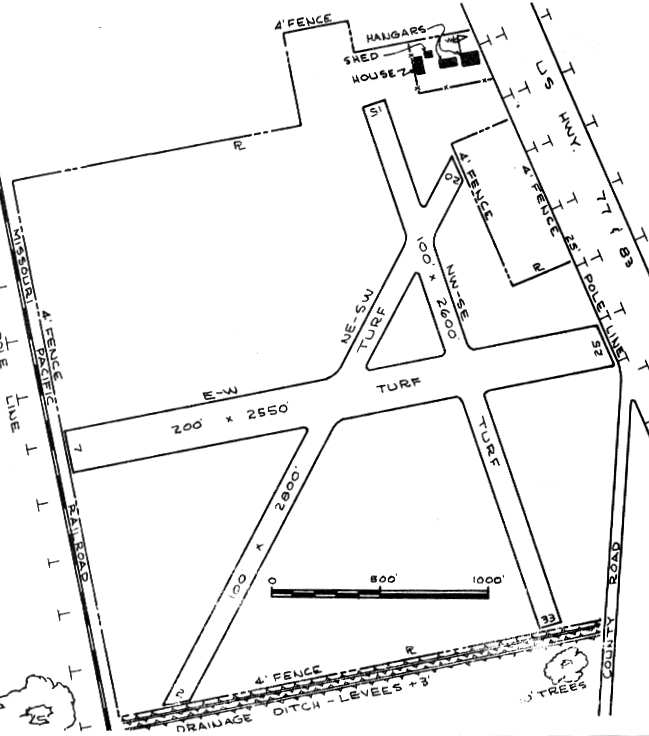
The 1963 TX Airport Directory (courtesy of Steve Cruse) depicted the field as having 3 turf runways, with the longest being the 2,800' Runway 2/20.
A house & 2 hangars were depicted at the northeast corner of the field.
The operator was listed as Mauldin Aircraft Inc., with the manager being L. W. Mauldin.
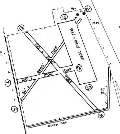
The 1967 TX Airport Directory (courtesy of Brad Stanford) showed that 2 new turf runways had been added: a 2,900 Runway 13/31 & a 1,800' x 500' Runway 15/33.
The manager was still listed as L.W. Mauldin.
The last depiction which has been located of Mauldin Airport was on the January 1972 Brownsville Sectional Chart (courtesy of Ron Plante).
It depicted Mauldin as having a 2,900' unpaved runway.
Les Mauldin died in 1978, after having been a pilot for 61 years.
At the time of his death he was still active in buying & selling aircraft parts & supplies.
Mauldin Airport was evidently closed at some point between 1972-79,
as it was no longer depicted on the July 1979 Brownsville Sectional Chart.
The 1995 USGS topo map no longer depicted any airfield at the site, but the name of the field lived on,
as a survey marker named "Mauldin" was still depicted at the site of the airport.
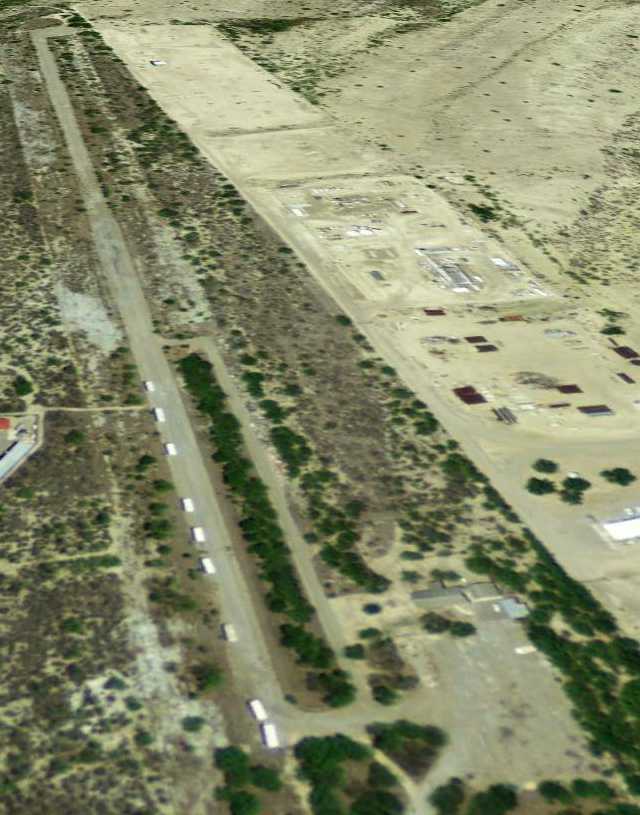
A 1995 USGS aerial photo showed the site of Mauldin Airport still existed as a cleared area, but no trace of any individual runways was still apparent.
A single hangar remained at the northeast corner of the former airport property
(the same hangar depicted depicted on the 1963 & 1967 airfield diagrams).
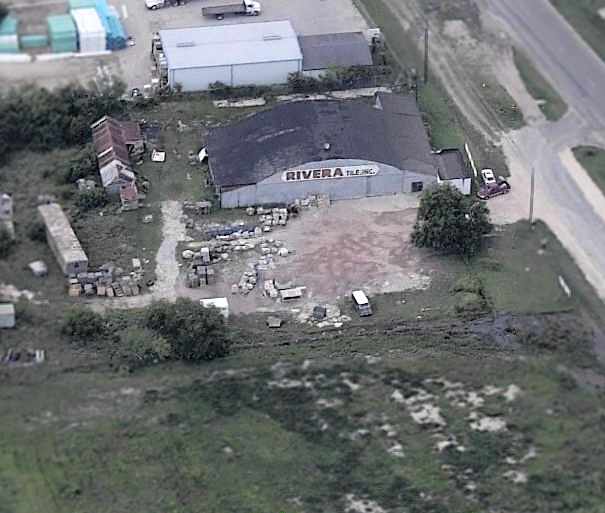
A circa 2006 aerial view looking north at a former hangar which remained at the northeast corner of the former airport property, labeled “Rivera Tile Inc.”.
A large “Academy Sports & Outdoors” store had been constructed over the southeast corner of the property at some point between 1995-2006.
Unfortunately, Todd Bohling reported in 2007 that the last vestige of the former Mauldin Airport is now gone:
“The hangar has been torn down; it is to be the site of a new Kohls Department store or a Conn's electronics store.
The whole former airport is now several stores - Home Depot, Academy Sports & several small strip malls & fast-food places.”
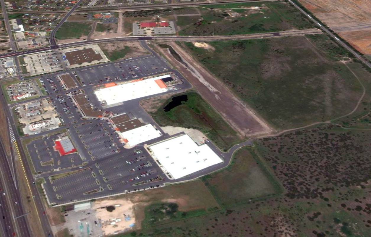
A 2012 aerial view looking south showed no trace remaining of Mauldin Airport.
The site of Mauldin Airport is located northwest of the intersection of Highway 77 & McAllen Road.
____________________________________________________
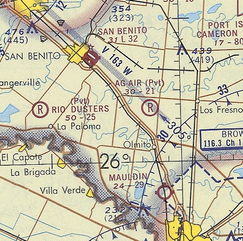
San Benito Municipal Airport (T66), San Benito, TX
26.132, -97.612 (Southwest of Houston, TX)
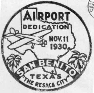
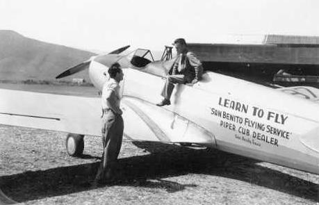
A postmark commemorated the 11/30/30 Dedication of San Benito Airport.
A wealth of information & photographs of this small airport were provided by Steve Cruse, of Cruse Aviation Parts, Inc..
Over the years the San Benito Airport progressed through municipal purchase of the land,
installation of equipment by the CAA, lease to the CAP,
lease to the US Navy, and finally lease to the San Benito Flying Service.
A postmark commemorated the 11/30/30 Dedication of San Benito Airport.
The Airport Directory Company's 1933 Airport Directory (courtesy of Chris Kennedy)
described San Benito as Site 2 along the Brownsville - Houston airway,
one of the Department of Commerce's network of Intermediate Fields.
The field was said to have 2 sod runways in an "L" shape: 2,640' northwest/southeast & 1,930 northeast/southwest.
The earliest aeronautical chart depiction which has been located of San Benito Airport was on the August 1935 Corpus Christi Sectional Chart.
The San Benito Airport was leased to the Civil Air Patrol by the city of San Benito in 1942,
and the CAP's Lower Coastal Unit was moved from Brownsville to San Benito.
The administration building was moved by the CAP from Brownsville to San Benito.
During the 2 years of service at San Benito, Unit 12 of the CAP patrolled the coast continuously
and was cited as playing a big part in assisting the Navy in eliminating the U-boat threat in the Gulf waters.
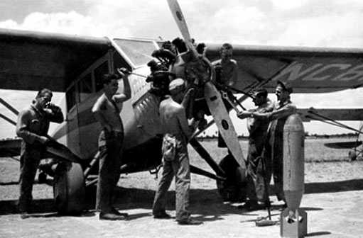
The earliest photo which has been located of San Benito Municipal Airport was a circa 1942-43 photo (courtesy of Steve Patti)
of an unidentified Civil Air Patrol plane being worked on, with a bomb in the foreground.
A circa 1942-43 photo (courtesy of Steve Patti) of San Benito, showing an unidentified Civil Air Patrol plane, hangar, and beacon light tower.
In 1943, after the CAP unit was moved, the Navy leased the airport,
and began coastal patrols from San Benito using a blimp manned by Navy personnel.
A concrete blimp mooring circle was built on the southwest corner of the field, just northeast of the hangars.
When the U-boats were driven from the Gulf, the Navy canceled its lease at the end of 1944.
When the CAP canceled its lease in 1944, the city bought the administration building & erected the hangar.
Steve Cruse's father & uncle operated Cruse Aviation, the FBO at San Benito starting in late 1944.
San Benito Airport was not yet depicted on the 1945 USGS topo map.
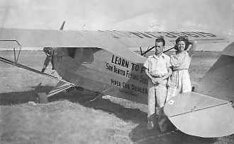
A 1945 photo of King & Sylvia Cruse in front of a Piper at San Benito (courtesy of Steve Cruse).
In 1945, the Harlingen Valley Morning Star described the field has as having 120 acres of smooth ground,
fenced & with boundary lights installed & operated by the Civil Aeronautics Administration.
A tall steel tower with automatic flashing beacon in the northwest corner of the field was also installed
and was operated by the CAA, which had $50,000 invested in the field facilities at the time.
There was an administration building housing offices of the San Benito Flying Service,
two flight training classrooms, 2 rooms for use of the local pilots club,
and 2 rooms used by the Department of Agriculture pink bollworm dusting experiments.
With the outbreak of the Second World War, a unit of the Coastal Air Patrol (a branch of the Civilian Air Patrol)
was formed at San Benito of civilian pilots overage or physically unqualified for Army or Navy air service.
This organization built a splendid record of service patrolling the coastal waters in the fight against U-boats.
Ganey Bradfield recalled, “On 12/31/45 (my 17th birthday),
I took my check ride for my Private Pilot's Certificate with 'King' Cruse at San Benito.
I passed & was the youngest Private Pilot in TX for a short time.”
![]()
A circa 1946 photo (courtesy of Steve Cruse) of the San Benito administration building (with observation tower),
which had been relocated by the CAP from Brownsville to San Benito in 1942.
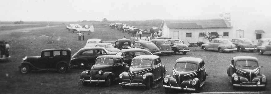
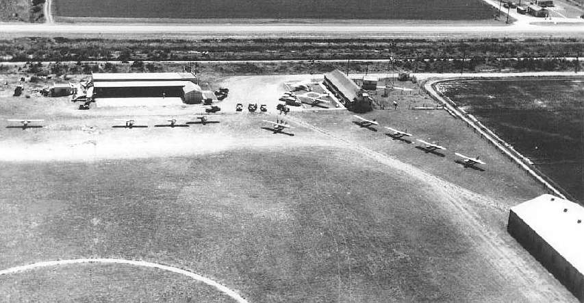
A circa 1946 photo (courtesy of Steve Cruse) looking south at San Benito during an airshow / fly-in.
A 1946 photo of a PT-19 of the San Benito Flying Service (courtesy of Steve Cruse).
A 1946 photo of Piper Cubs being assembled at San Benito (courtesy of Steve Cruse).
A 1946 photo of Pipers in front of the hangars at San Benito (courtesy of Steve Cruse).
A 1946 photo of a Fly-In at San Benito (courtesy of Steve Cruse).
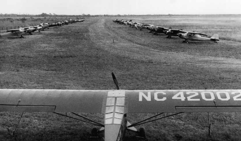
Immediately after the end of WW2, San Benito Airport became a busy transshipment point for the delivery of general aviation aircraft to Latin America.
An assembly line was set up for the reassembly of Piper Aircraft,
which were shipped from the Piper factory to San Benito stacked six per railroad box car.
A total of 107 aircraft were delivered through San Benito in 1946.
A report by the local Chamber of Commerce covering the year 1946 said that a 140' x 60' hangar had been built at the airport.
The report also made the claim that "more light planes are flown in the Lower Rio Grande Valley than in any other part of the USA."
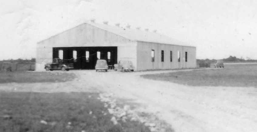
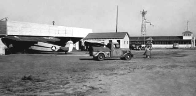
A circa 1940s photo (courtesy of Steve Cruse) showing the 'new' hangar at San Benito,
either during construction or shortly after its completion.
Compare the hangar photo with the 2002 photo of the same hangar (several paragraphs below).
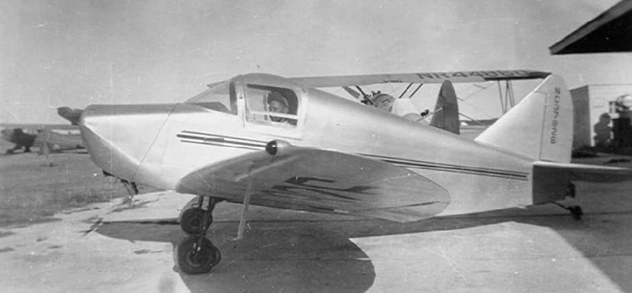
A circa 1946-48 photo of a rare Culver Cadet (NC37826) on the ramp at San Benito,
with a Stearman (NR44880) in the background (courtesy of Steve Cruse).
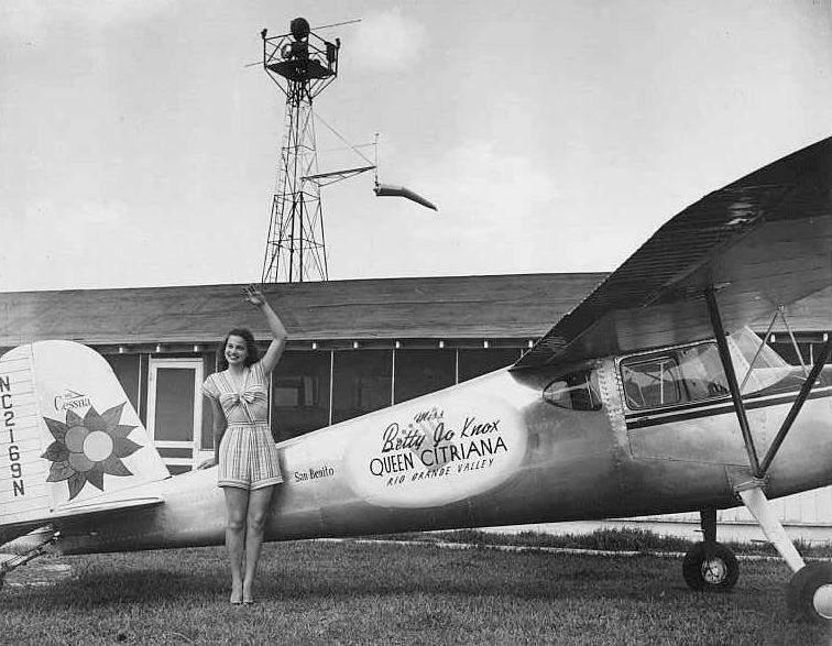
A 1947 promotional shot of the "Queen Citriana" in front of a Cessna at San Benito (courtesy of Steve Cruse).
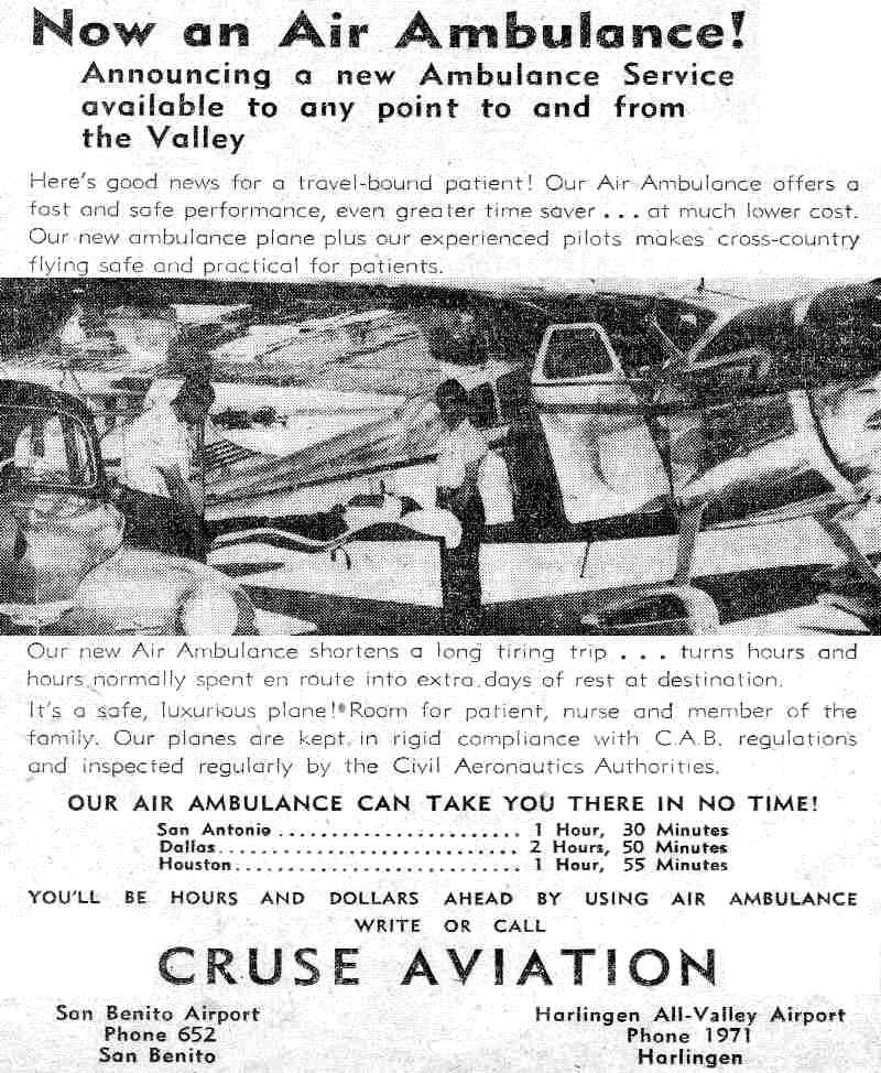
An advertisement from the 8/23/49 issue of the All Valley Evening News (courtesy of Steve Cruse)
showing a Cessna 195 of Cruse Aviation outfitted as an air ambulance).
A 1949 TX General Land Office aerial view looking north depicted San Benito Airport as having 3 grass runways, the former blimp circle, and a few hangars on the west side.
No aircraft were visible on the field.
A November 1950 photo (courtesy of Steve Cruse) of a very unusual crop-duster conversion of a Piper J-3 Cub at San Benito.
Note the cropped-down rear fuselage. Steve noted, “I wonder what useful load was?”
A 1952 aerial view of the hangars at San Benito (courtesy of Steve Cruse). Note the WW2-era blimp mooring circle at bottom-left.
The hangar in the lower right corner is the only building remaining in the 1996 photo below.
In 1952, Cruse Aviation purchased six new Cessnas for use in a contract for flying USDA inspectors along the Mexican border.
A picture of runway construction appeared in the 7/7/52 issue of the All Valley Evening News (courtesy of Steve Cruse).
The caption read: “Preparing a new runway at San Benito Municipal Airport
requires the work of heavy earth-moving machinery.
The new strip runs southeast to northwest, in the path of the prevailing gulf wind.
It is part of San Benito's bid to become a major air terminal for private & executive-type aircraft.”
The August 1954 Corpus Chrisi Sectional Chart (courtesy of Chris Kennedy) depicted San Benito as having a 2,500' unpaved runway.
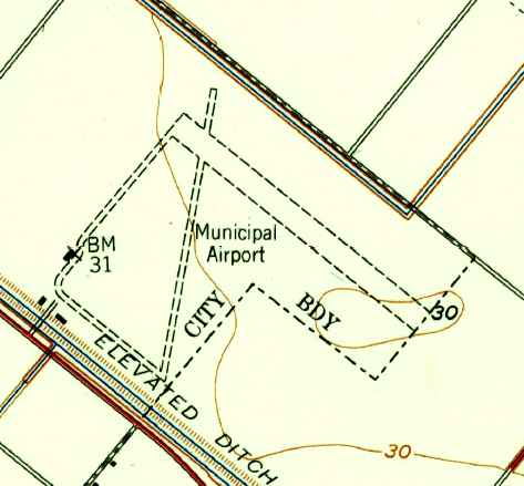
The earliest topo map depiction which has been located of San Benito Airport was on the 1956 USGS topo map.
It depicted the “Municipal Airport” as having 2 unpaved runways.
Cruse Aviation eventually relocated from San Benito to Houston Hobby Airport.
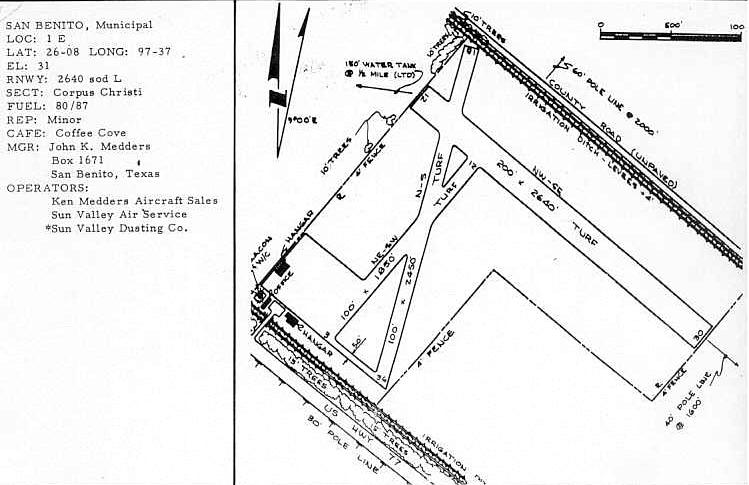
As listed in the 1963 TX Airport Directory (courtesy of Steve Cruse),
San Benito Airport consisted of 3 turf runways (the largest, 12/30, was 2,640' long), with 2 hangars on the southwest corner,
and the operators were listed as Sun Valley Air Service, Sun Valley dusting and Ken Medders Aircraft Sales.
The 1966 Brownsville Local Aeronautical Chart (courtesy of John Price) depicted San Benito Airport as having a 2,60' unpaved runway.
By the time of the 1982 AOPA Airport Directory (courtesy of Ed Drury),
San Benito's Runway 12/30 had been paved & lengthened to 3,200',
Runway 18/36 was also paved, and Runway 3/21 had been abandoned. The operator was Young Flying Service.
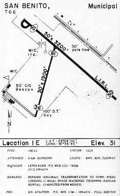
The 1985 TX Airport Directory (courtesy of Steve Cruse) listed San Benito Airport's operator as B/S Aviation.
The last depiction which has been located of San Benito Airport was on the June 1993 Brownsville Sectional Chart (courtesy of Ron Plante).
It depicted San Benito as having a 3,200' paved runway.
The last photo which has been located showing aircraft at San Benito Airport was a 1995 USGS aerial view looking north,
on which 2 light aircraft were visible parked near the hangars on the west side.
The only remaining active runway was 12/30, which had been lengthened to 3,500'.
Note the WW2-era blimp mooring circle still evident in the southwest corner.
San Benito Airport was evidently closed at some point between 1995-2002,
as it was depicted as an abandoned airfield on 2002 aeronautical charts.
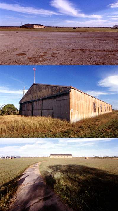
A series of photos of how the former San Benito Airport appeared in 2002 (courtesy of Steve Cruse).
Note the windsock still on the hangar (middle photo), and the remains of the blimp mooring circle (lower photo).
Compare the hangar photo with the 1940s photo of the same hangar (several paragraphs above).
Steve Cruse drove by the former San Benito Airport in 2002, and reported that "There is a truck driving school there now.
The 1946 hangar is still there - it looks pretty raggedy. The rotating beacon is still there - it must have been well built."
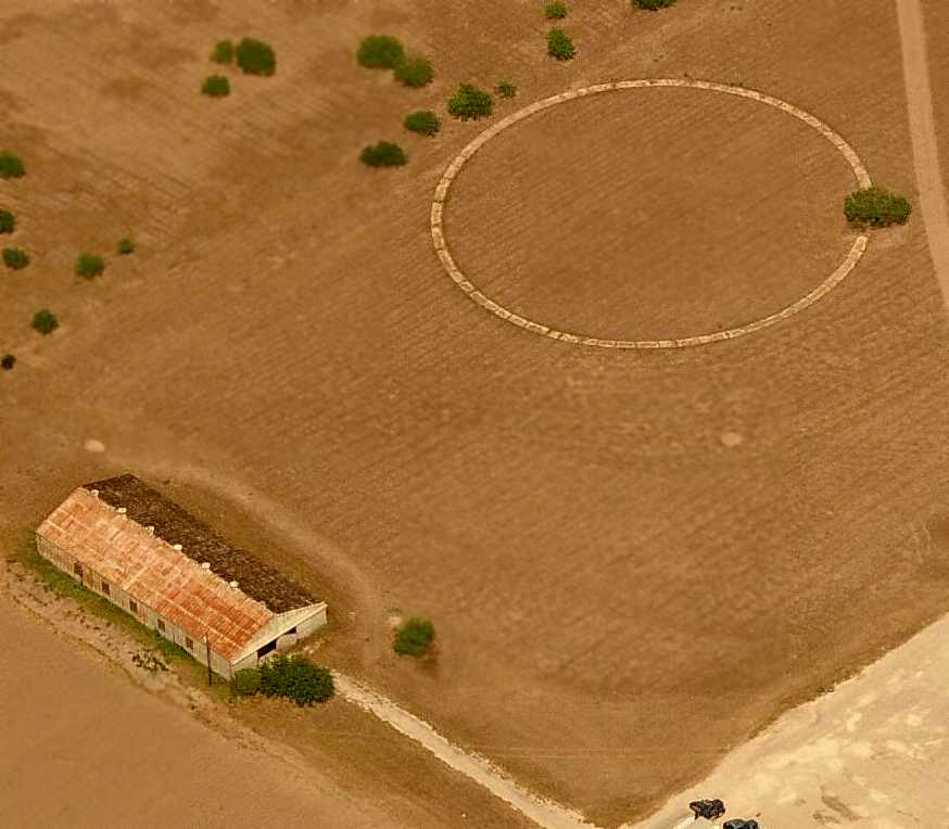
A circa 2006 aerial view looking east at the 1940s hangar & the WW2-era concrete blimp mooring circle at San Benito.
A circa 2006 aerial view looking south at a later-vintage hangar & the rotating beacon light tower at San Benito.
Steve Cruse observed, “The rotating beacon is still standing in 2006.”
Amazingly a 2016 aerial view looking north showed the San Benito Airport remained intact though more overgrown.
The pavement of Runway 12/30 & 2 paved taxiways remained evident, along with the WW2-era blimp mooring circle, and 2 hangars still remained erect.
A 2022 aerial view showed the San Benito Airport hangars & blimp mooring circle had been removed at some point between 2016-2022,
covered by buildings of the AEP TX San Benito Service Center.
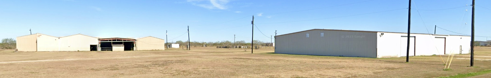
A 2023 photo looking east at 2 hangars which remain on the east side of the San Benito Airport site.
See also: Harlingen Valley Morning Star, 9/23/45.
____________________________________________________
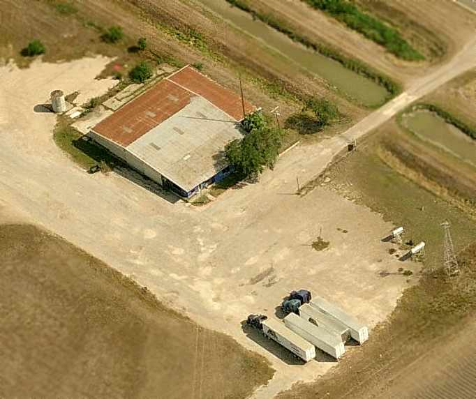
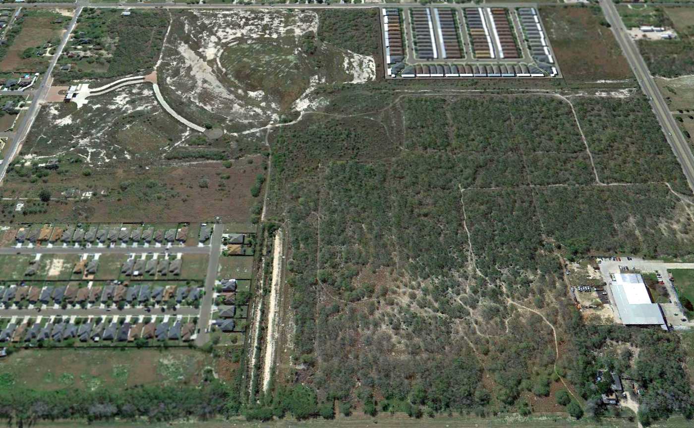
Harlingen Airport (original location), Harlingen, TX
26.169, -97.713 (Southwest of Houston, TX)
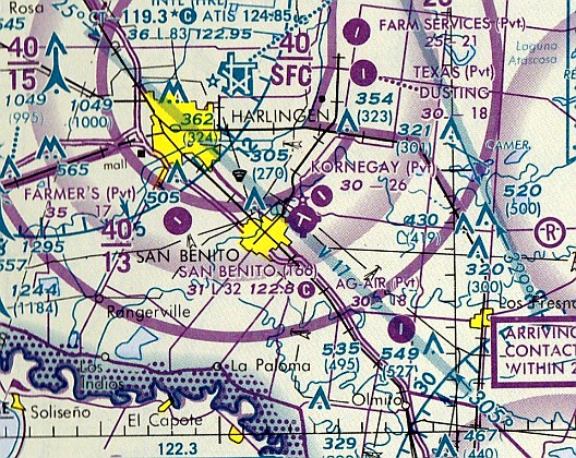
“Harlingen Airport, as depicted on the August 1935 Corpus Christi Sectional.
The date of establishment of Harlingen's original airport has not been determined.
The earliest depiction of Harlingen Airport which has been located was on the August 1935 Corpus Christi Sectional Chart.
It depicted Harlingen as a commercial/municipal airport.
Tim Vasquez reported, “On the August 1946 [Sectional] Chart it was shown as “Harlingen COM AP” which suggested it was designated for agriculture operations or freight,
as this was the same time that All-Valley Municipal Airport was taking over the old Harlingen AAF airfield.”
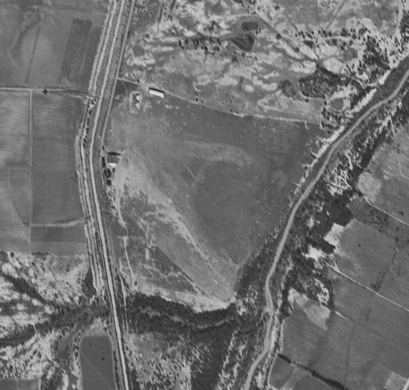
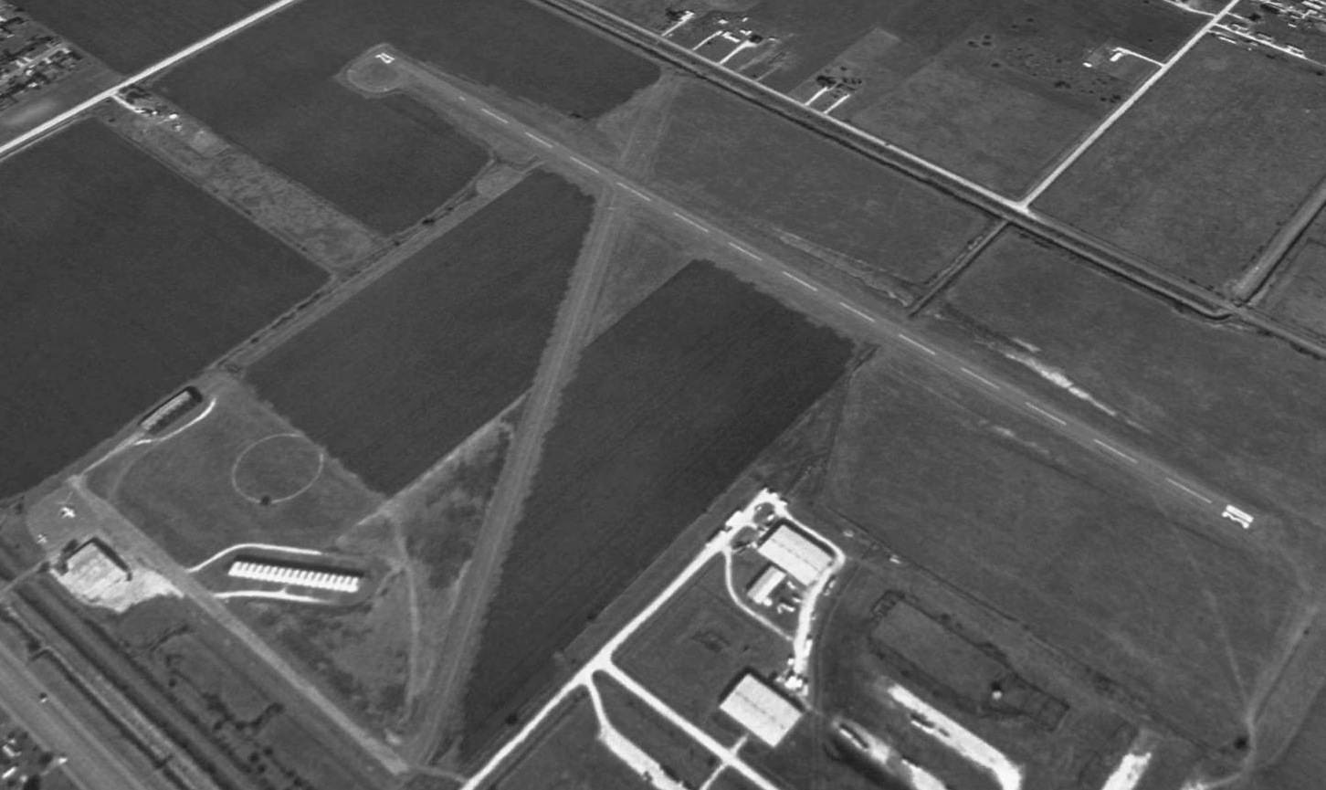
The earliest photo which has been located of Harlingen Airport which a 12/2/46 USGS aerial view.
It depicted Harlingen as having 2 grass runways & 2 small hangars on the northwest side.
The only topo map depiction which has been located of the original Harlingen Airport was on the 1953 USGS topo map, which depicted Harlingen as a private airfield.
The last photo which has been located showing the original Harlingen Airport while open was a 4/7/53 USGS aerial view.
An airport circle marking was southeast of the runway intersection.
The last depiction which has been located of the original Harlingen Airport was on the August 1954 Corpus Christi Sectional (courtesy of Chris Kennedy).
It depicted Harlingen as having a mere 1,800' unpaved runway.
The original Harlingen Airport was evidently closed at some point in 1954-55, as it was no longer depicted on the 1955 Corpus Christi Sectional Chart.
It had presumably been replaced by the new Harlingen Airport to the northwest.
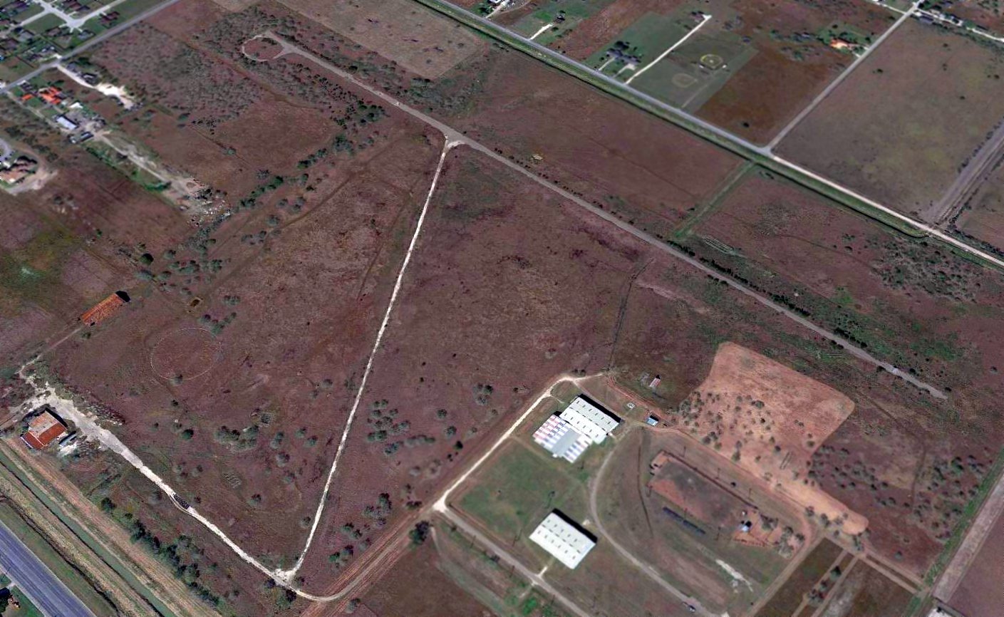
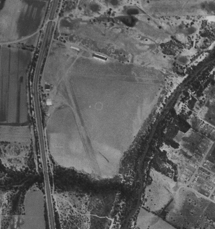
The site of the original Harlingen Airport was largely unchanged in 1962 & 1970 aerial photos.
A 1983 aerial photo showed that a golf course had been constructed on the site of the original Harlingen Airport at some point between 1970-83.
A 2023 aerial view looking north showed no trace remaining of the original Harlingen Airport.
As of 2026, street maps label the site of the original Harlingen Airport as the Tony Butler Golf Course.
Thanks to Tim Vasquez for pointing out this airifeld.
____________________________________________________
Harlingen Municipal Airport / Harvey Richards Field, Primera, TX
26.205, -97.755 (Southwest of Houston, TX)
“Harlingen (New)” Airport, as depicted on the August 1954 Corpus Christi Sectional (courtesy of Chris Kennedy).
No airfield was depicted at this location on the 1945 USGS topo map or the March 1954 Corpus Christi Sectional Chart
The earliest depiction of Harvey Richards Field which has been located
was on the August 1954 Corpus Christi Sectional (courtesy of Chris Kennedy).
It depicted “Harlingen (New)” Airport as having a 3,600' paved runway.
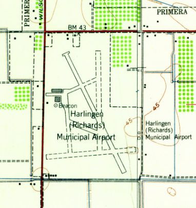
The earliest topo map depiction which has been located of Harvey Richards Field was on the 1956 USGS topo map.
It depicted “Harlingen (Richards) Municipal Airport” as having 1 paved northwest/southeast runway, 2 unpaved runways,
and taxiways leading to a ramp, buildings, and a beacon on the west side.
According to a 7/1/60 Valley Morning Star newspaper article (courtesy of Drew van Horne),
Trans-Texas Airways shifted their operations over to Harvey Richards Field from Harlingen Air Force Base on the night of 6/30/60.
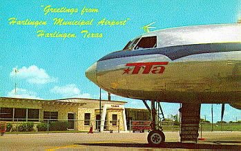
A circa 1961-67 postcard of a Trans-Texas Airways Convair 240 or 600 in front of the Harlingen Municipal Airport terminal (courtesy of Drew van Horne).
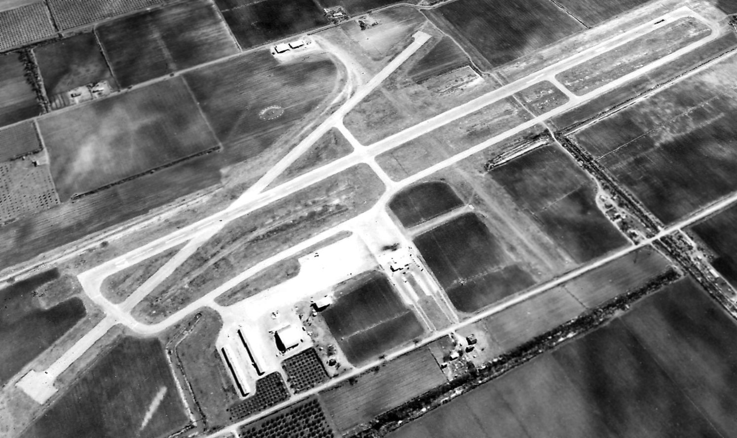
A 1962 TX General Land Office aerial view looking southeast depicted Harvey Richards Field to have 2 paved runways.
A ramp on the northwest side had 4 buildings, and 2 small hangars were located on the east side.
Several light aircraft were parked on the northwest ramp.
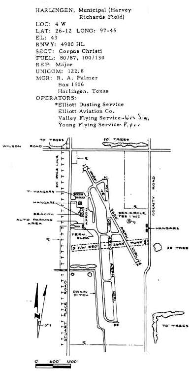
As it appeared in the 1963 TX Airport Directory (courtesy of Steve Cruse),
Harvey Richards Field consisted of 2 paved runways (the primary Runway 19/35, was 4,900', asphalt),
a third turf runway, taxiways, an apron, several hangars & a terminal building.
The operators were listed as Elliot Dusting Service, Elliot Aviation Company,
Valley Flying Service, and Young Flying Service.
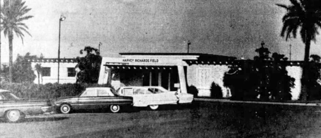
An undated photo of the Harvey Richards Field terminal from a 10/28/64 newspaper article (courtesy of Drew van Horne).
The 1966 Brownsville Local Aeronautical Chart (courtesy of John Price)
depicted Harlingen Municipal Airport as having 2 paved runways, with the longest being 4,900'.
Accordng to the article “Airplanes, Airports, and Airlines in Harlingen” (courtesy of Drew van Horne),
the City of Harlingen approved the sale of Harvey Richards Field to the Harlingen Country Club for $133,650 on 8/17/67.
According to a 12/19/67 Brownsville Herald newspaper article (courtesy of Drew van Horne),
Trans-Texas Airways shifted their operation from Harvey Richards Field on the night of 12/20/67
back to the much larger Harlingen AFB after the military base was closed & the airfield became available for civil reuse.
The last depiction which has been located of Harlingen / Harvey Richards Field
was on the February 1968 Corpus Christi Sectional Chart.
It depicted Harlingen as having 2 paved runways, with the longest being 4,900'.
At some point between 1968-80, the Harvey Richards Field property was redeveloped into the Palm Valley golf course,
as the 1980 USGS topo map depicted the golf course covering the airport site,
and the airport was no longer depicted on the 1983 Brownsville Sectional Chart.
A 1995 aerial photo showed the golf course having erased any trace of Harlingen Municipal Airport.
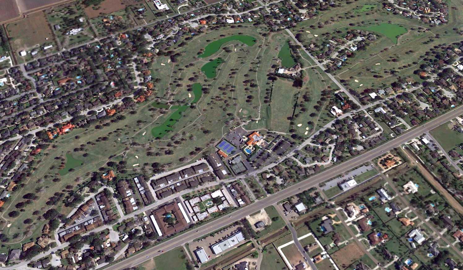
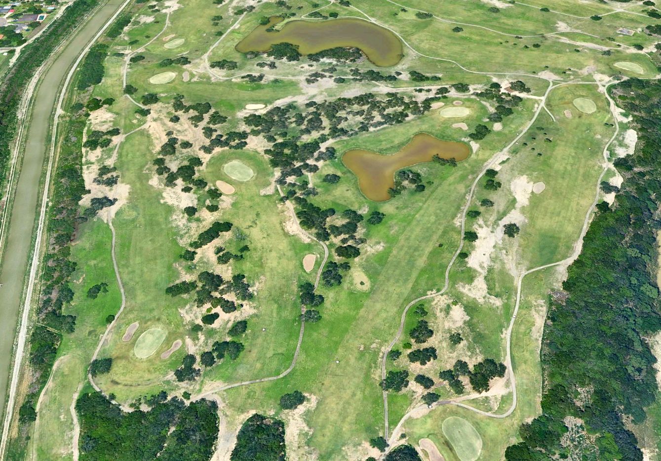
A 2016 aerial view looking southeast showed no obvious trace remaining of the Harlingen Municipal Airport.
However, a close inspection reveals the airport terminal building remains: the small gray building in between the tennis-courts at the bottom-center of the photo.
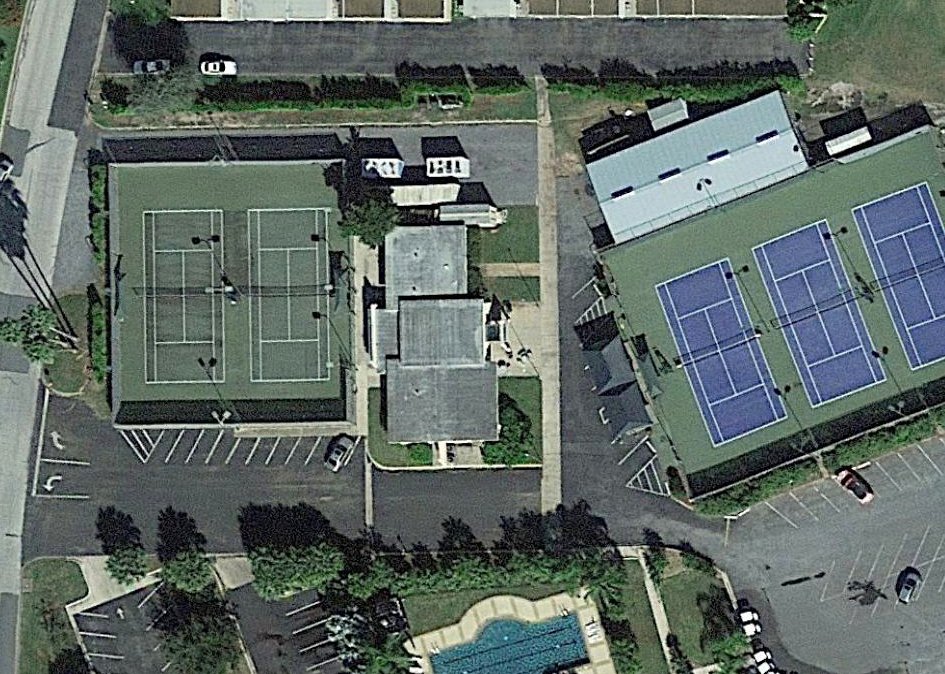
A 2017 aerial view of the former Harlingen Municipal Airport terminal building, now reused as a country club office building.
As of 2019, the City of Palm Valley website reported, “Harvey Richard Harlingen Municipal Airport... there is one building that still exists. It is the tennis building at the country club.
If you go in the building you will see in the center of the floor a logo that dates back to when the city constructed the building to serve as the terminal.”
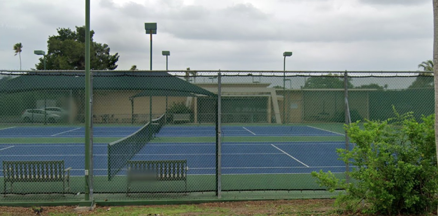
A 2023 photo (courtesy of Phil Dorsett) looking east at the former Harlingen Municipal Airport terminal building, now reused as a country club office building.
Compare to the 1960s photo of the terminal to see the distinctive architecture of the entrance.
The site of Harlingen Municipal Airport is located southeast of the intersection of Wilson Road & Stuart Place Road.
Thanks to Steve Cruse for information about Harvey Richards Field.
____________________________________________________
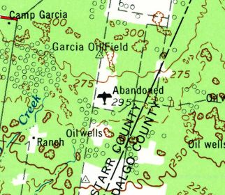
Moore Auxiliary Army Airfield #3 / Rio Grande Field, Sullivan City, TX
26.345, -98.565 (Southwest of Corpus Christi, TX)
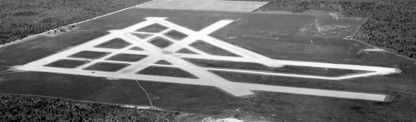
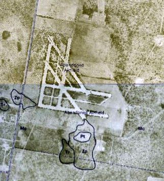
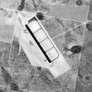
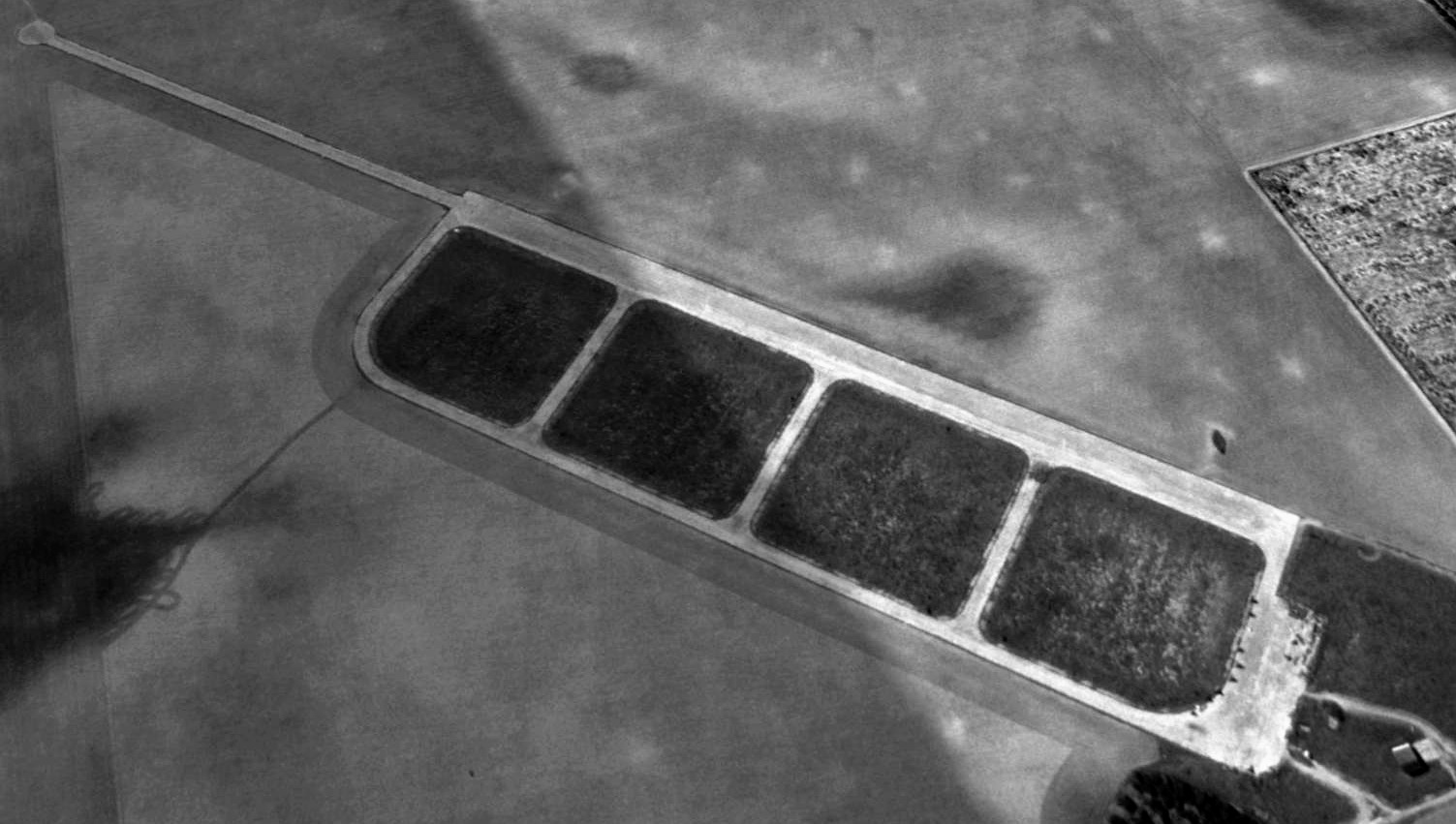
A circa 1943-44 USAAF aerial view looking north at Moore Auxiliary Army Airfield #3 (courtesy of Brian Rehwinkel).
Moore Auxiliary #3 / Rio Grande Field was one of 3 satellite fields used during WW2 by Moore AAF,
which conducted basic & advanced single engine pilot training.
Brian Rehwinkel reported of Moore Auxiliary #3, “According to the AAF history for the airfield, the airfield opened in 1941.
I don’t know if the field was used before paved runways were added in 1943.
Apparently, Auxiliary # 2 was originally an all-grass airfield, so it is possible all the auxiliary fields were grass.”
A 5/15/43 AAF list of airfields of the Gulf Coast Training Center (courtesy of Ron Plante)
described Moore Field Auxiliary #3 as having 6 asphalt 3,000' runways (an amazing array for an auxiliary field).
Brian Rehwinkel reported, “The paved runways were completed at Auxiliary # 3 in September 1943.
All 6 runways were 3,000’ & this field even had 3 taxiways, which really was something of a luxury for such a small training airfield at the time.
The runways were on a 384 acre parcel, which was leased.
I don’t know if the U.S. later purchased the property, given the $250,000 investment in the runways & taxiways.”
Moore #3 was not yet depicted on the December 1943 Corpus Christi Sectional Chart.
The earliest depiction which has been located of Moore Aux #3 was a circa 1943-44 USAAF aerial view looking north (courtesy of Brian Rehwinkel).
It depicted Moore Aux #3 as having an amazing complement of 6 paved runways & 3 taxiways.
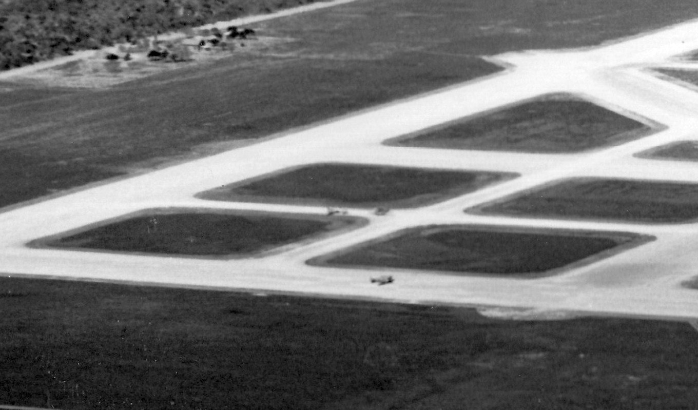
A closeup from the circa 1943-44 USAAF aerial view of Moore Auxiliary Army Airfield #3 (courtesy of Brian Rehwinkel).
Brian Rehwinkel noted, “You can barely make out some aircraft on the field.”
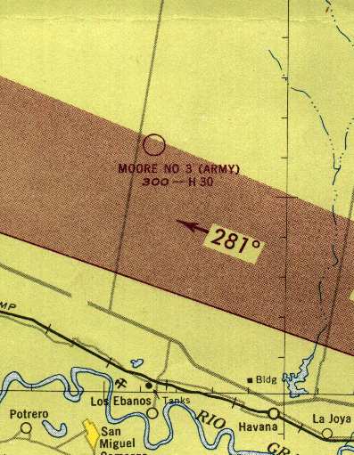
The earliest aeronautical chart depiction which has been located of Moore Auxiliary #3 was on the June 1944 Corpus Christi Sectional Chart,
which depicted "Moore #3 (Army)" as an auxiliary airfield.
The 1947 Brownsville Local Aeronautical Chart (courtesy of Steve Cruse) depicted "Moore #3 (Army)" as a military airfield.
Moore #3 was evidently reused for some period of time as a civilian airport,
as "Moore #3" was depicted on the 1949 Corpus Christi Sectional Chart (according to Chris Kennedy),
without having any indication of military status.
The last aeronautical chart depiction which has been located of Moore #3
was on the March 1951 Corpus Christi Sectional Chart.
It depicted Moore #3 as having a 3,000' paved runway.
Moore #3 was apparently abandoned at some point in 1951,
as it was no longer depicted on the August 1951 Corpus Christi Sectional Chart.
Moore #3 was labeled as an abandoned airfield on the 1957 USGS topo map.
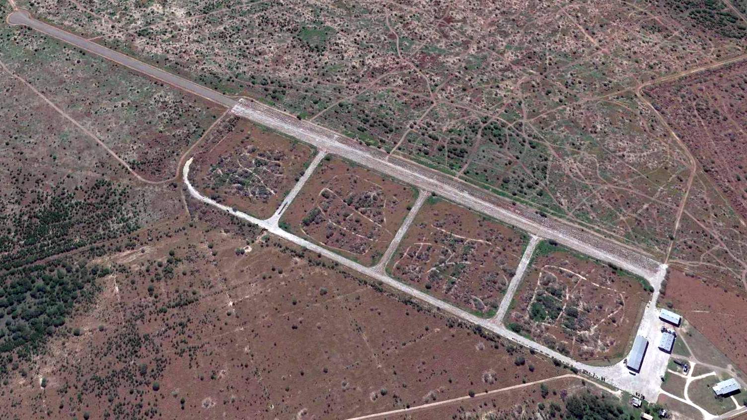
A circa 1960-65 aerial view of Moore Auxiliary Army Airfield #3,
from a 1972 USDA Soil Survey of Starr County (courtesy of Michael Kersten).
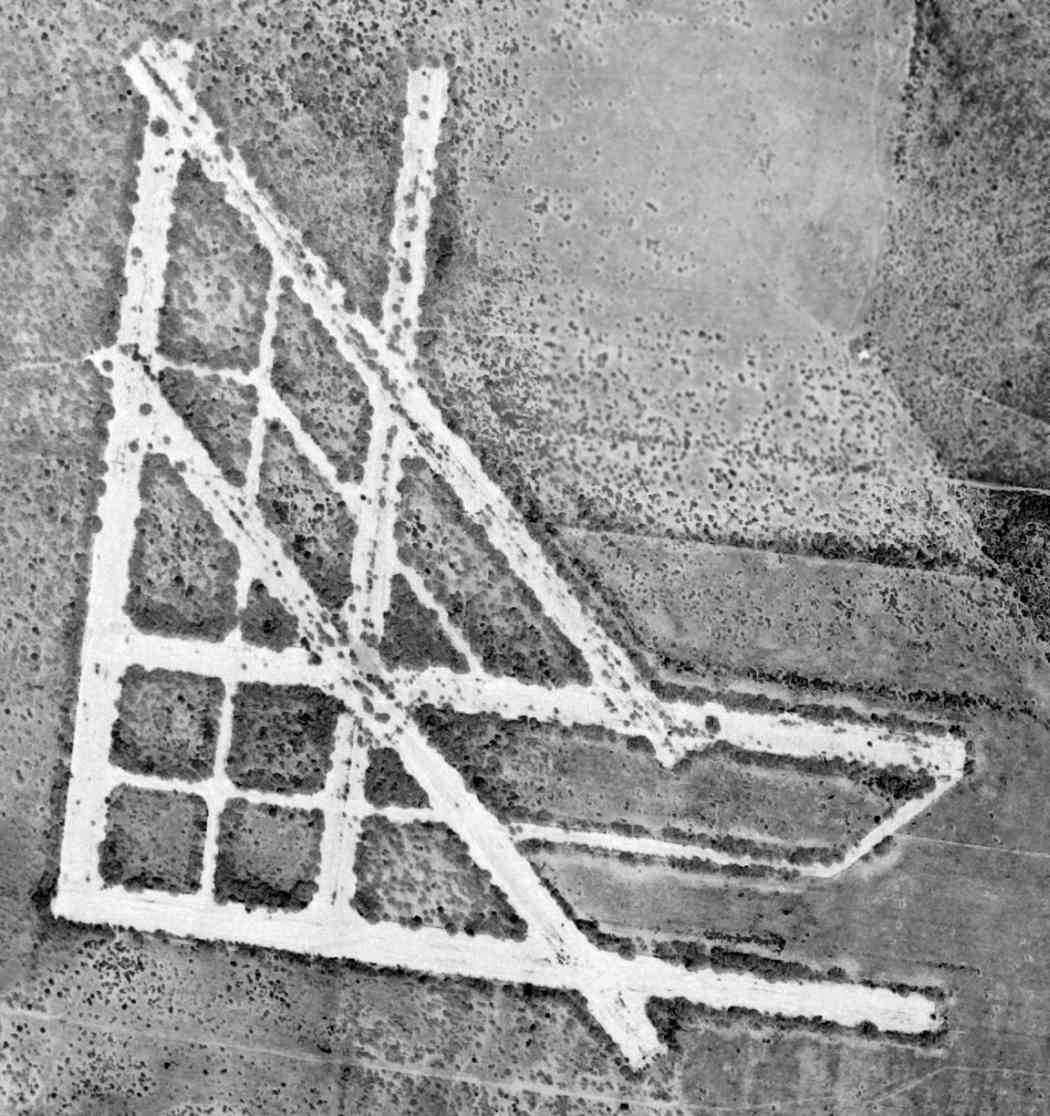
A 3/2/64 USGS aerial view depicted Moore #3 to have no less than 6 paved 3,000' runways & numerous taxiways.
For an auxiliary airfield, Moore #3 was unusually extensive, having with 6 runways.
Moore #3 was no longer depicted at all on the 1966 Brownsville Local Aeronautical Chart (courtesy of John Price).
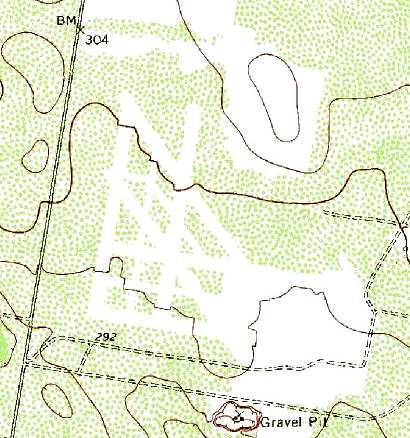
Although unlabeled, the outlines of no less than six 3,000' runways & numerous taxiways
were clearly still depicted on the 1980 USGS topo map.
Moore #3 was not depicted at all on the 1988 USGS topo map.
In the 1995 USGS aerial photo, the former runways had been removed,
with all of the area of the former airfield having reverted to farmland.
But the faint traces of the numerous runways & taxiways are still clearly apparent in the photo.
A 2005 aerial photo showed that the faint outlines of the numerous runways & taxiways were still perceptible.
The site of Moore #3 is located northwest of the intersection of County Line Road & Sevenmile Road, 5 miles north of Sullivan City.
____________________________________________________
Moore Auxiliary Army Airfield #2 / Mission Field / Arrowhead Ranch Airfield, McCook, TX
26.55, -98.44 (Southwest of Corpus Christi, TX)
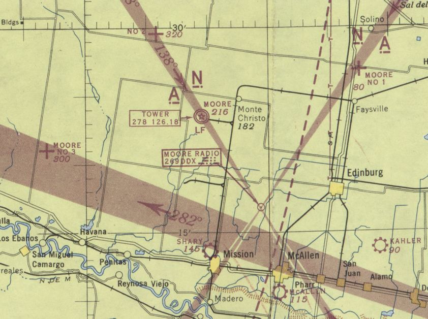
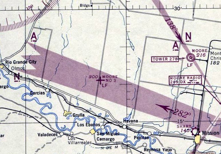
Moore Aux "#2", as depicted in relation to its parent airfield, on the January 1945 Corpus Christi Sectional Chart (courtesy of Chris Kennedy).
Photo of the airfield while open has not been located.
Moore Aux #2 was one of 3 satellite fields used during WW2 by Moore AAF,
which conducted basic & advanced single engine pilot training.
A 5/15/43 AAF list of airfields of the Gulf Coast Training Center (courtesy of Ron Plante)
listed Moore Field Auxiliary #2 but did not specify any runway configuration.
The date of construction of Moore Aux #2 is unknown.
It was not yet depicted on the December 1943 Corpus Christi Sectional Chart (courtesy of Chris Kennedy).
The earliest depiction of Moore Aux #2 which has been located was on the January 1945 Corpus Christi Sectional Chart (courtesy of Chris Kennedy).
It depicted "#2" as an auxiliary airfield.
Moore Aux #2 was evidently reused for some period of time after WW2 as a private civilian airfield,
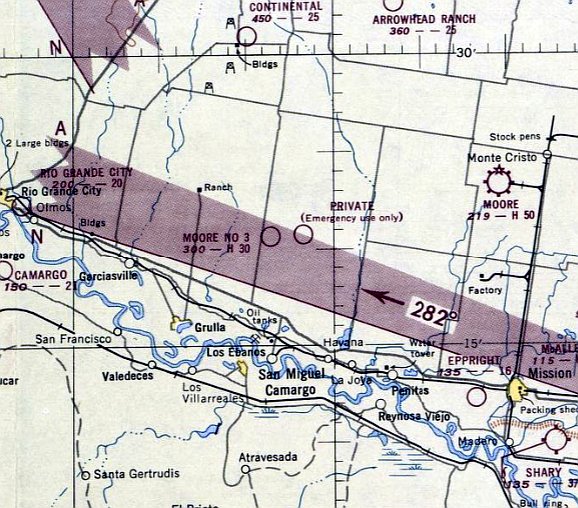
as it was labeled "Private (Emergency use only)" on the 1949 Oklahoma City Sectional Chart (according to Chris Kennedy).
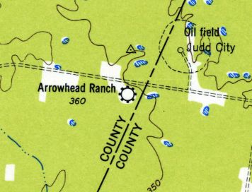
Moore Aux #2 was evidently renamed Arrowhead Ranch during its period of civilian reuse,
as that is how it was labeled on the 1949 USGS topo map.
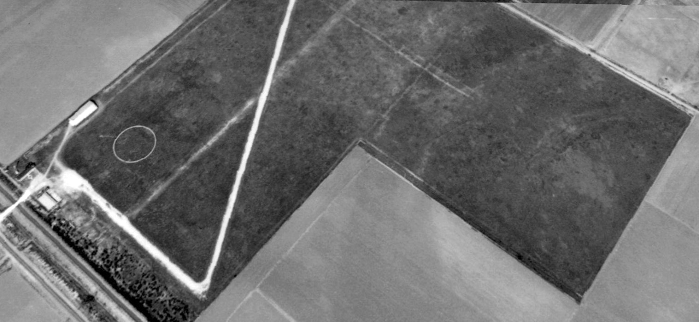
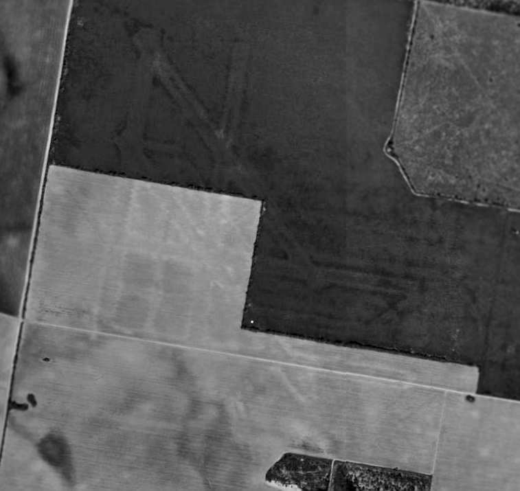
The earliest photo which has been located of the Moore Aux #2 airfield was a 4/15/55 USGS aerial view.
It showed Moore #2 as having a single paved northwest/southeast runway, a paved parallel taxiway, a ramp, and 4 connecting taxiways.
The airfield was labeled as “Arrowhead Ranch (Abandoned)” on the 1957 USGS topo map.
Moore #2 was labeled “Abandoned airport” on the 1966 Brownsville Local Aeronautical Chart (courtesy of John Price).
The 1972 USGS topo map depicted Moore Aux #2 as having a single paved northwest/southeast runway,
a paved parallel taxiway, a ramp, and 4 connecting taxiways.
The airfield was still depicted (labeled simply "Landing Strip") on the 1988 & 1990 USGS topo maps.
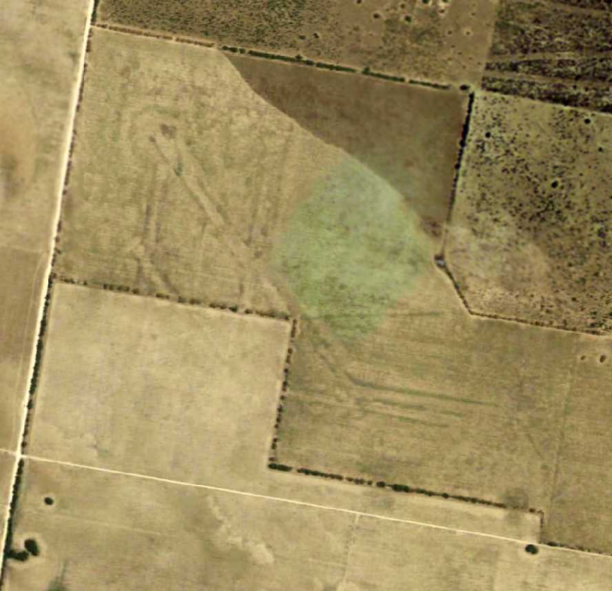
A 1995 USGS aerial view looking southwest depicted Moore Aux #2 as having an additional 1,900' runway extension on the south end,
which was roughly half the width of the original runway segment.
This runway lengthening was presumably done for the post-WW2 civil reuse of the airfield.
Moore Aux Airfield #2 was still depicted as an abandoned airfield on 2002 aeronautical charts.
A 2016 aerial view looking southwest at Moore Aux #2 showed several buildings had been added at the north end of the field at some point between 1995-2005,
but the field remains otherwise unchanged.
Moore Aux Airfield #2 is located northwest of the intersection of Route 681 & Route 490, 5 miles northwest of McCook.
____________________________________________________
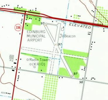
Edinburg Municipal Airport, Edinburg, TX
26.304, -98.21 (Southwest of Corpus Christi, TX)
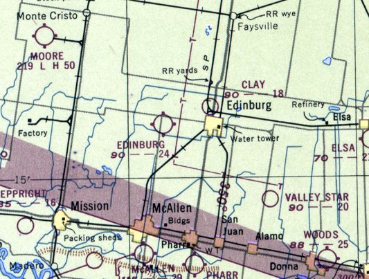
Edinburg Airport, as depicted on the January 1948 Corpus Christi Sectional Chart.
This municipal airport was evidently established at some point between 1946-49,
as it was not yet depicted at all on the August 1946 Corpus Christi Sectional Chart.
The earliest depiction of Edinburg Municipal Airport which has been located was on the January 1948 Corpus Christi Sectional Chart,
which depicted "Edinburg" as having a 2,400' unpaved runway.
Edinburg Airport, as depicted on the 1949 USGS topo map.
The earliest photo which has been located of Edinburg Municipal Airport was a 4/15/55 USGS aerial view.
The northwest/southeast runway had evidently been newly paved.
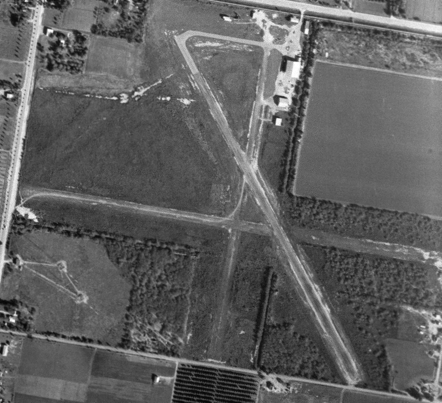
An 11/24/61 USGS aerial view depicted Edinburg Municipal Airport as having 1 paved runway, 2 unpaved runways,
and several hangars on the northeast side.
The 1962 AOPA Airport Directory described Edinburg as having a 2,800' blacktop Runway 13/31, a 3,100' turf runway 9/27, and a 2,400' turf Runway 18/36.
The operator was listed as Tripplett Aviation.
The 1963 USGS topo map depicted Edinburg Municipal Airport as having 3 runways, with the northwest/southeast runway paved.
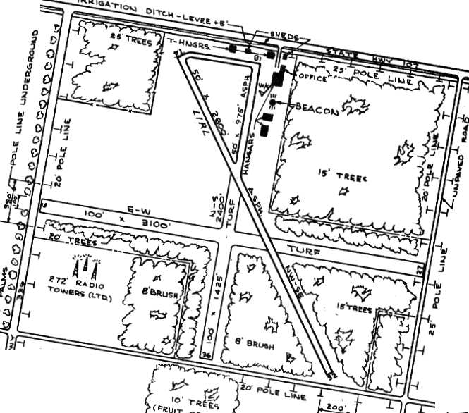
The 1963 TX Airport Directory (courtesy of Steve Cruse) depicted Edinburg Municipal as having 5 hangars & a beacon
along the north end of Runway 18/36.
The manager was listed as Jack Owens,
and the operators were listed as Southwick Airplane Service & Tripplett Aviation & Spraying Service.
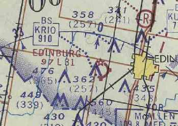
Edinburg Airport, as depicted on the July 1969 Brownsville Sectional Chart (courtesy of Chris Kennedy).
Edinburg Airport was depicted in basically the same configuration in the 1970 TX Airport Directory (courtesy of Ray Brindle)
as that is how it was listed in the 1963 TX Airport Directory.
Apparently, Edinburg Airport was closed when the more substantial Moore Auxiliary Army Airfield #1
was made available for civilian reuse, becoming "Edingburg International Airport".
The date of closure of Edinburg Municipal Airport is unknown,
but was apparently between 1970-82,
as it was not listed among active airfields in the 1982 AOPA Airport Directory
nor depicted on the 1983 Brownsville Sectional Chart.
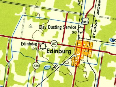
The airfield was depicted as "Edinburg Municipal Airport" on the 1983 USGS topo map,
but was not depicted at all on the 1988 USGS topo map.
Edinburg Municipal was no longer depicted at all (not even as an abandoned airfield) on recent aeronautical charts.
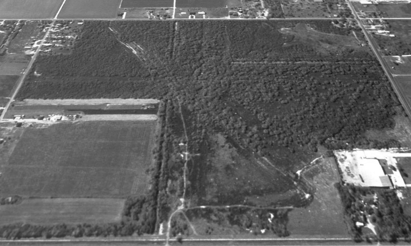
A 1995 USGS aerial view looking south showed the former Edinburg Municipal Airport runways had become overgrown,
but their outlines were still distinctly apparent by comparing with the airfield layout diagram.
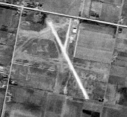
A 2014 aerial view looking south at the site of Edinburg Municipal Airport showed that houses had been constructed on the northeast & southwest corners,
but portions of the north/south & east/west runways were still recognizable.
The site of Edinburg Municipal is located southeast of the intersection of Routes 107 & 336.
____________________________________________________
Or if you prefer to contact me directly concerning a contribution (for a mailing address to send a check),
please contact me at: paulandterryfreeman@gmail.com
If you enjoy this web site, please support it with a financial contribution.
____________________________________________________
This site covers airfields in all 50 states.