Abandoned & Little-Known Airfields:
Texas: Lubbock area
© 2002, © 2025 by Paul Freeman. Revised 3/22/25.
This site covers airfields in all 50 states: Click here for the site's main menu.
____________________________________________________
Please consider a financial contribution to support the continued growth & operation of this site.
Howard County Municipal Airport (revised 3/22/25) - Lamesa Field (revised 5/17/24) – Lubbock AAF / Reese AFB (revised 5/16/24)
Lubbock AAF Aux #4 / Abernathy Field / Abernathy Municipal Airport (revised 3/22/25)
Terry County Aux Airfield / Reese AF Aux (revised 3/1/25) - Rhodes Airport / Shallowater Airport (revised 12/3/23)
South Plains AAF Auxiliary #2 / Idalou Airport (revised 12/3/23) - U & S Flying Service Airfield / Hamilton Field (revised 5/16/24)
____________________________________________________
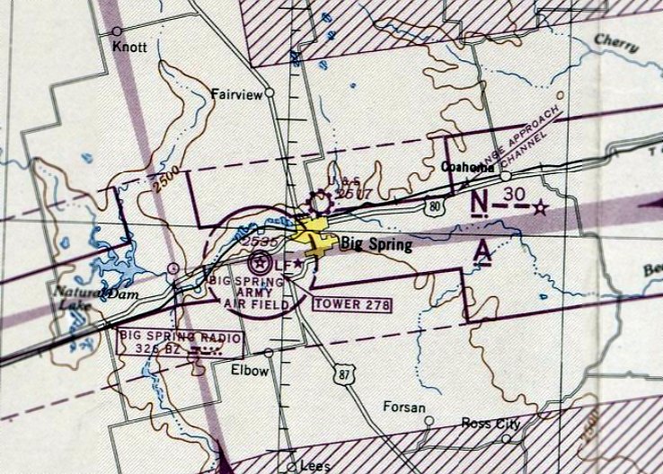
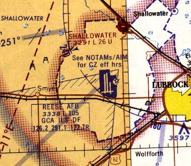
South Plains Army Airfield Auxiliary #2 / Idalou Airport, Lorenzo, TX
33.716, -101.605 (Northeast of Lubbock, TX)
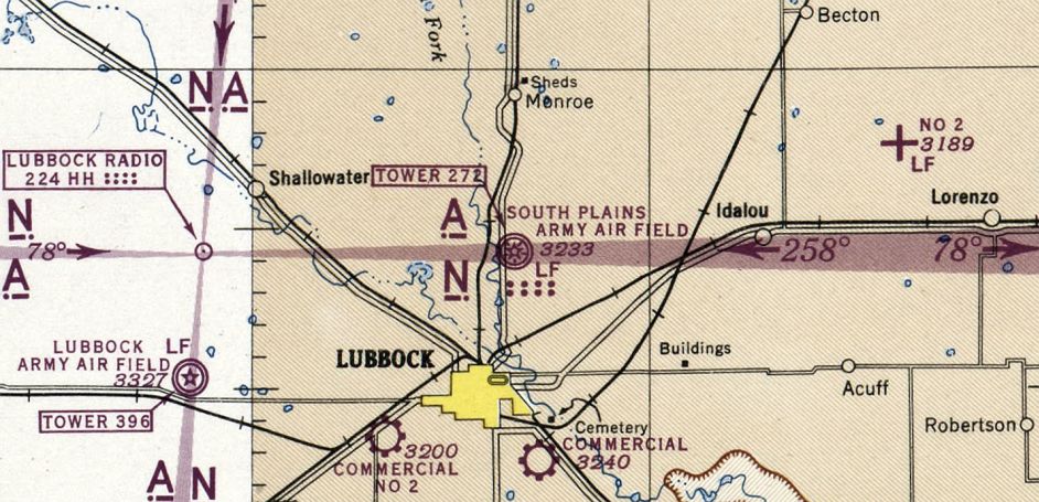
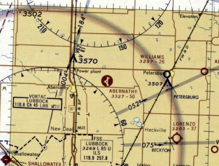
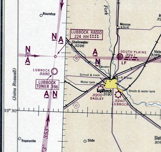
South Plains Army Airfield Auxiliary #2, as depicted on the March 1944 Dallas Sectional Chart (courtesy of Bob Morris).
This airfield was evidently established at some point between 1940-44,
as it was not yet depicted on the September 1940 Dallas Sectional Chart.
South Plains Army Auxiliary Airfield #2 was evidently built to support flight training operations at nearby South Plains Army Airfield,
which was activated on 9/11/42.
The earliest depiction of which has been located of South Plains Army Auxiliary Airfield #2 was on the March 1944 Dallas Sectional Chart (courtesy of Bob Morris).
It depicted “No 2” as an auxiliary airfield.
South Plains Army Airfield Auxiliary #2 was evidently reused at some point between 1944-46 as a civilian airport named Idalou,
as that is how it was depicted on the March 1946 Dallas Sectional Chart.
Idalou Airport was evidently closed (for reasons unknown) at some point between 1946-50, as it was no longer depicted on the February 1950 Dallas Sectional Chart.
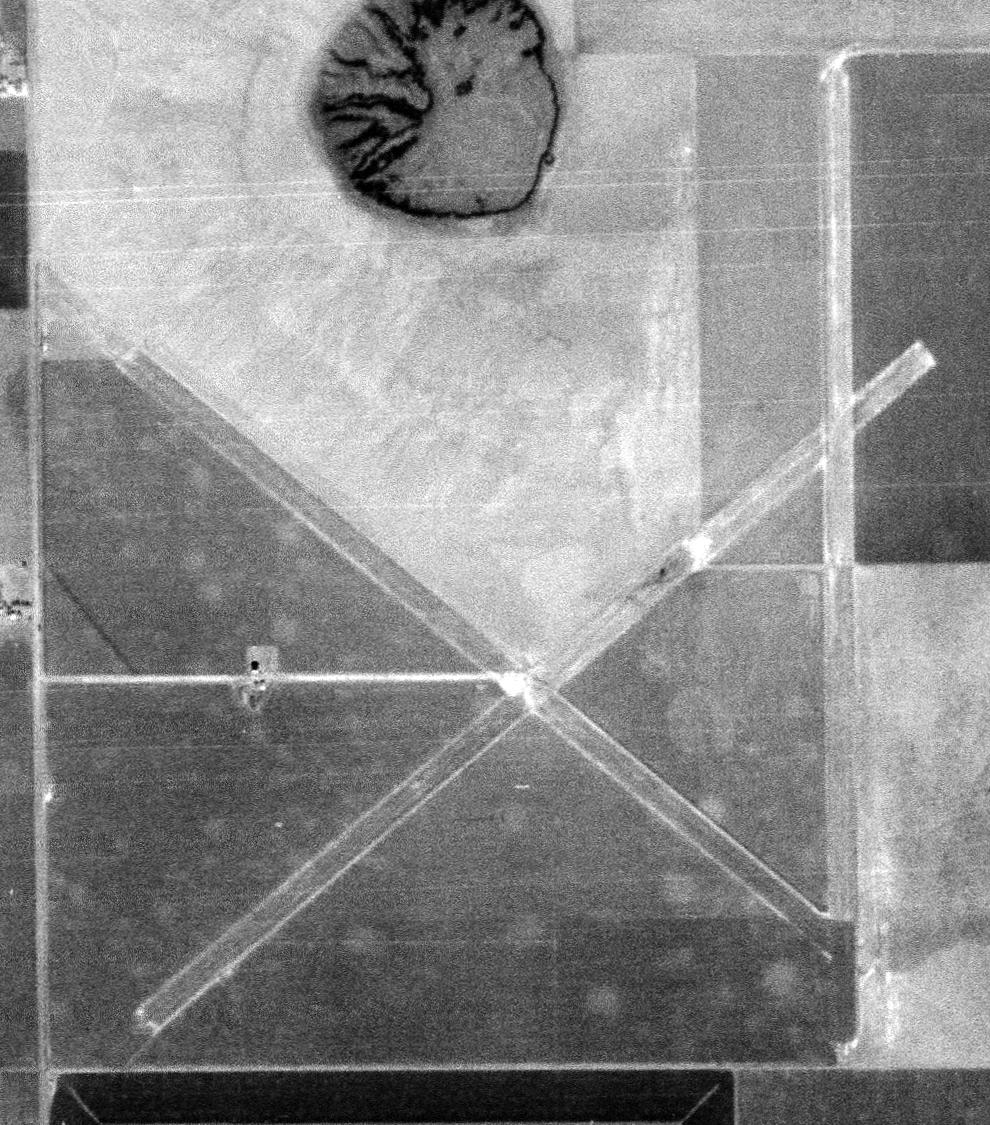
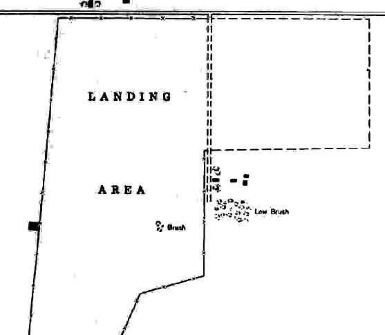
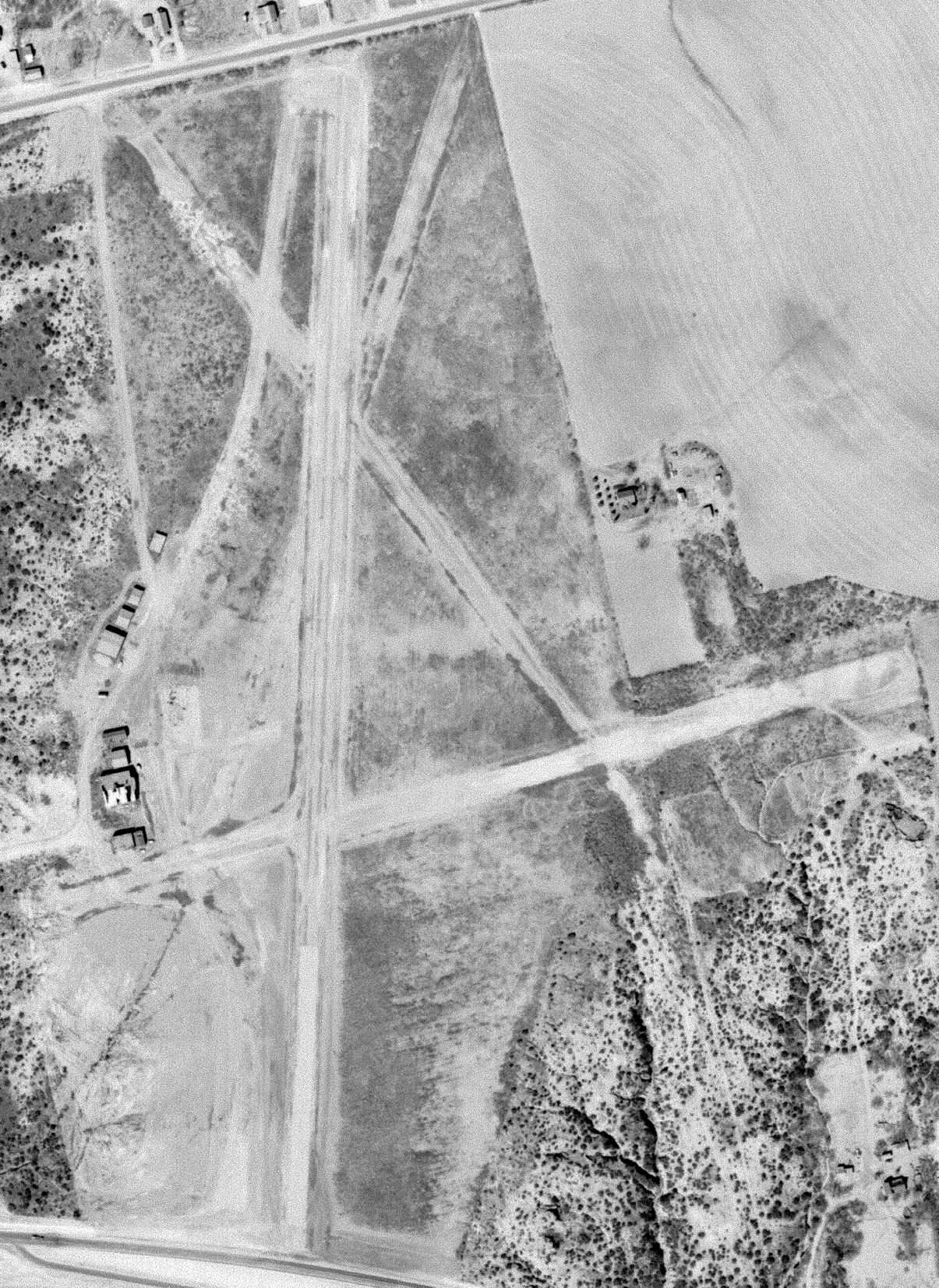
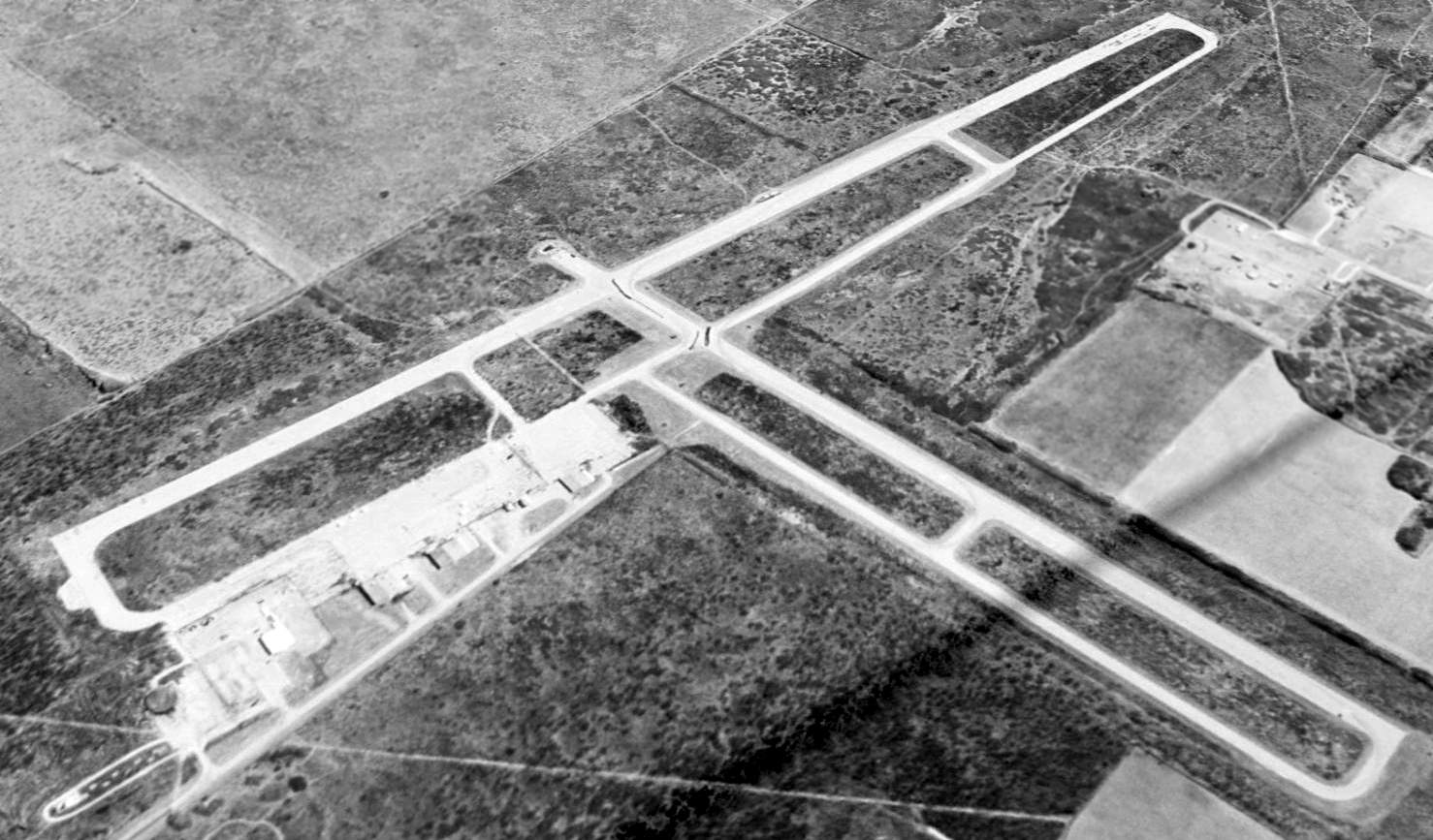
The earliest photo which has been located of the former South Plains Army Airfield Auxiliary #2 was a 2/28/54 Army Map Service aerial view (courtesy of Bob Morris).
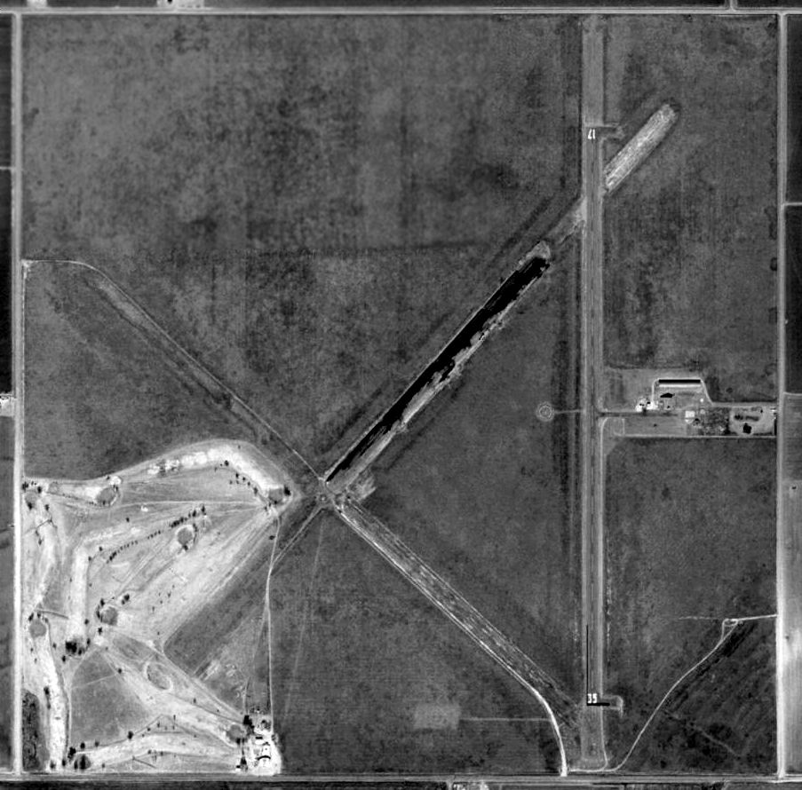
The airfield had 3 runways, all approximately 5,000' long, oriented southwest/northeast, northwest/southeast, and north/south.
A few small buildings sat on the west side, but there did not appear to be any hangars, nor indication of any recent aviation use.
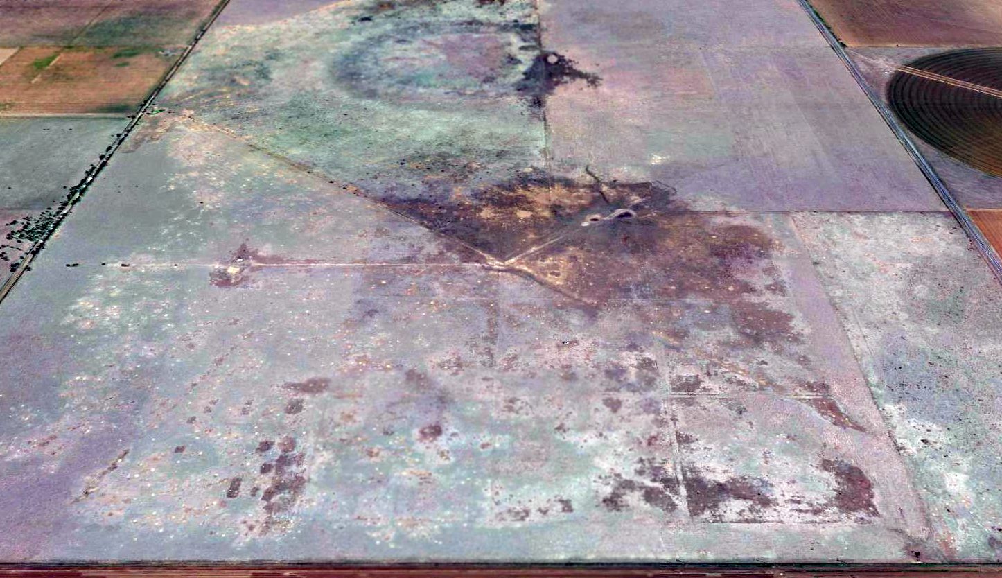
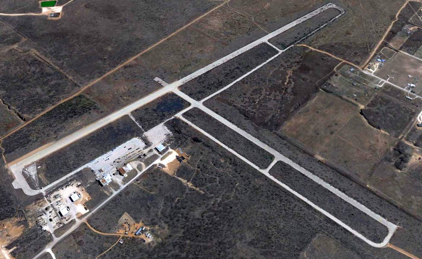
A 2016 aerial view looking south at the site of South Plains Army Airfield Auxiliary #2 shows the 3 former runways remained barely recognizable..
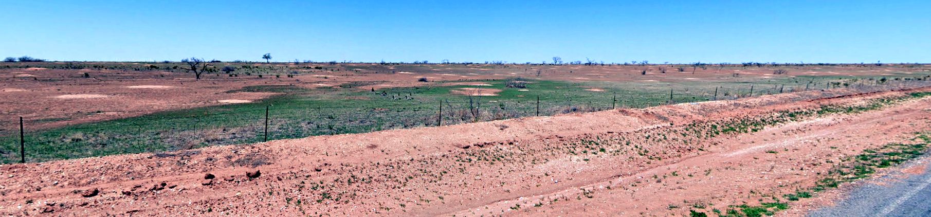
A 2023 photo looking northwest showed no trace of South Plains Army Airfield Auxiliary #2.
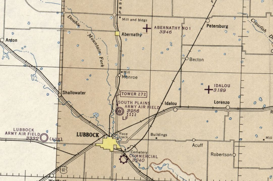
The site of South Plains Army Airfield Auxiliary #2 is located northwest of the intersection of Route 789 & Road 5800.
Thanks to Bob Morris for pointing out this airfield.
___________________________________________________
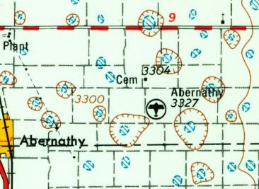
Lubbock Army Airfield Auxiliary #4 / Abernathy Field / Abernathy Municipal Airport (F83), Abernathy, TX
33.844, -101.765 (Northeast of Lubbock, TX)
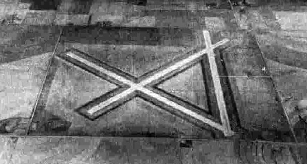
A 10/12/43 aerial view looking north at “Lubbock Army Airfield Auxiliary #4 (Abernathy Field)” from the 1945 AAF Airfield Directory (courtesy of Scott Murdock).
Abernathy Field was not yet depicted on the February 1943 Dallas Sectional Chart.
According to Wikipedia, “Abernathy Municipal Airport was built during World War II & opened in November 1943
as Abernathy Auxiliary Field by the United States Army Air Forces as an auxiliary field for nearby Lubbock Army Air Field & South Plains Army Air Field.
The field was initially built for use by Lubbock Army Air Field, but following the activation of South Plains Army Air Field, was assigned to that base.”
The earliest depiction which has been located of Abernathy Field
was a 10/12/43 aerial view looking north from the 1945 AAF Airfield Directory (courtesy of Scott Murdock).
It depicted “Lubbock Army Airfield Auxiliary #4 (Abernathy Field)” as having 3 paved runways.
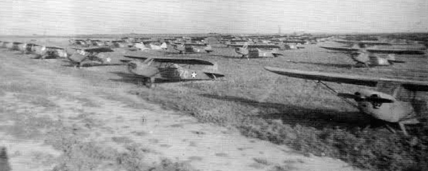
A WW2 era photo of large numbers of Army L-2/3/4 aircraft at Abernathy Field (courtesy of John Voss).
The liaison aircraft were used by the glider pilot training program at nearby South Plains AAF, which then conducted “dead stick” landing training at Abernathy Field.
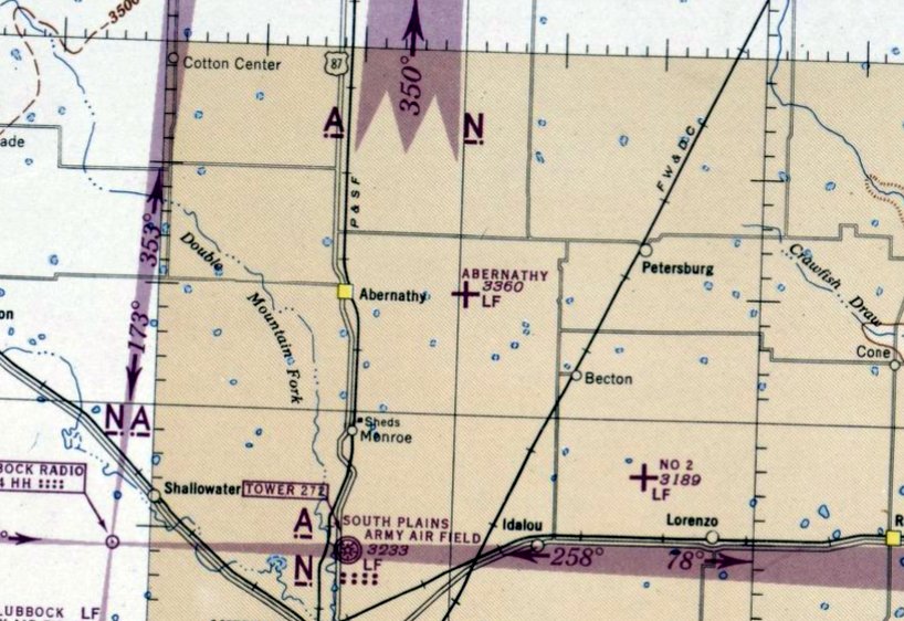
The earliest aeronautical chart depiction which has been located of Abernathy Field was on the March 1944 Dallas Sectional Chart.
It depicted Abernathy as an auxiliary airfield.
According to Wikipedia, “In 1944 after the conclusion of training operations at South Plains Army Air Field, Abernathy reverted to Lubbock Army Air Field for the duration of the war.”
The 1945 AAF Airfield Directory (courtesy of Scott Murdock) described “Lubbock Army Airfield Auxiliary #4 (Abernathy Field)”
as an 840 acre square-shaped property having 3 asphalt 5,000' runways.
The field was said to not have any hangars, to be owned by the U.S. Government,
operated by the Army Air Forces, but to be inactive.
According to Wikipedia, “At the end of World War II, the field was declared surplus & released to the War Assets Administration for disposal.
The field was given to the City of Abernathy for use as a civil airport.”
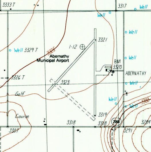
The 1954 USGS topo map depicted Abernathy as a civilian airport.
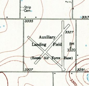
The 1957 USGS topo map depicted Abernathy as having 3 paved runways,
labeled as “Auxiliary Landing Field (Reese Air Force Base)”.
The 1963 TX Airport Directory (courtesy of Steve Cruse)
depicted Abernathy Municipal Airport as having 3 asphalt runways, although the northwest portion of Runway 12 had been abandoned.
Two hangars, a house, and another building were depicted on the east side.
Mike Kmetz recalled, “Abernathy Airport... My first solo flight with 3 landings was here.
I started my instruction with the Aero Club at Reese AFB.
Due to the intensive jet traffic there, my instructor flew us over to Abernathy where I could do my solo unmolested in a Cessna.
I recall using the northeast/southwest runway with the golf course at the south end.
I remember that because on one practice takeoff, my instructor pulled back the power so I could try an emergency landing.
As I headed down toward that golf course we saw golfers on the fairway split & head off into the weeds.
We aborted the approach & headed back to Reese.
Back then (1963) it seemed that was the only runway in use. I don’t think there were any structures at the airport back then.”
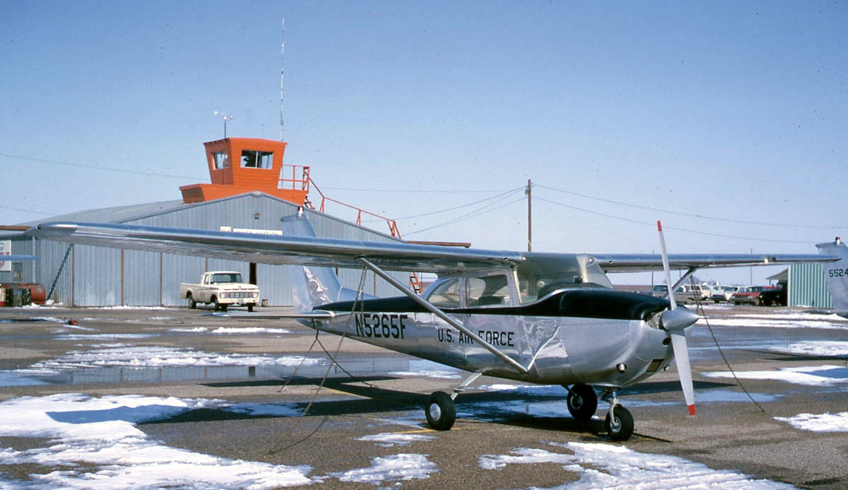
A 1966 photo by Bob Krone of an Air Force Cessna T-41 at Abernathy Airport (courtesy of Alan Hodgson).
Bob Krone recalled, “Abernathy... I was in Class 67-D at Reese & our T-41 training was approximately November 1965 - February 1966.
We had many trips in that old blue bus from Reese.”
The last aeronautical chart depiction which has been located of Abernathy Field was on the July 1968 Dallas Sectional Chart.
It depicted Abernathy as having 3 paved runways, with the longest being 5,000'.
The pavement of Abernathy's Runway 12/30 had evidently been removed at some point between 1963-70,
as the 1970 TX Airport Directory depicted Abernathy Municipal Airport as having 2 asphalt runways & a turf Runway 12/30.
A 3/22/76 USGS aerial photo depicted Abernathy as having 3 paved runways.
The 1985 USGS topo map depicted Abernathy Municipal Airport as having 2 paved runways & 1 unpaved runway.
A 1995 USGS aerial photo showed Abernathy Municipal Airport as having a paved Runway 17/35, with the pavement of the 2 other runways having been removed.
A 2002 aerial view showed that Runway 17/35 had been newly repaved with asphalt, but did not yet have any runway markings.
A 2005 aerial view showed that Runway 17/35 had been painted with standard runway markings.
Scott Grissman reported, “In 2007 the Wings Miniature Aircraft Society Club with permission of city manager Mike Cypert begin flying Radio-Controlled model aircraft on the north 1/3 of the runway at Abernathy Airfield.”
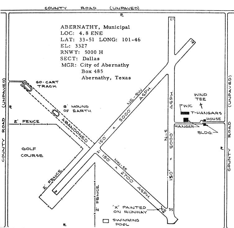
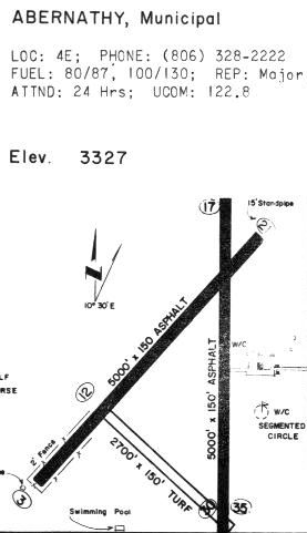
As of 2009, the TX Airport Directory described Abernathy Municipal Airport as having a 4,000' paved Runway 17/35,
with a ramp & 3 small buildings on the east side.
The manager was listed as Mike Cypert, and it listed Porterfield Propellors as the Fixed Base Operator.
For a 1-year period ending 4/22/12, the FAA's Airport/Facility Directory data showed Abernathy Municipal Airport
conducted an average of 50 takeoffs or landings per month.
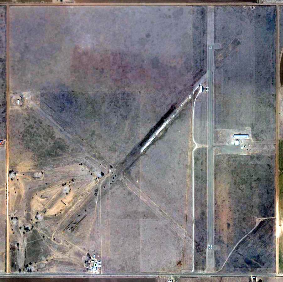
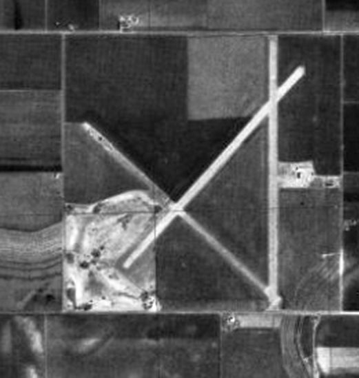
The last photo which has been located showing Abernathy Municipal Airport still marked as an active airfield was a 2013 aerial view.
The facility of the Wings Miniature Aircraft Society Club can be seen on the northwest side of Runway 17.
Abernathy Municipal Airport was evidently closed (for reasons unknown) at some point between 2013-2014,
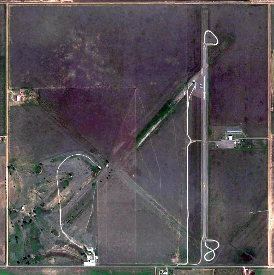
as a 2014 aerial view showed the 1 remaining runway marked with yellow closed-runway “X” symbols.
As of 2015, the FAA's Airport/Facility Directory still listed Abernathy Municipal Airport, but with a status of “Closed permanently”.
It was also still depicted on the September 2016 Dallas Sectional Chart, but noted as “Closed”.
Randy Coller reported of Abernathy Airport, “Last inspection was 5/16/20. At that time, it was listed as 'Closed Indefinitely'.
It had been closed for a long time. When I was there, it was being used as truck driver training.”
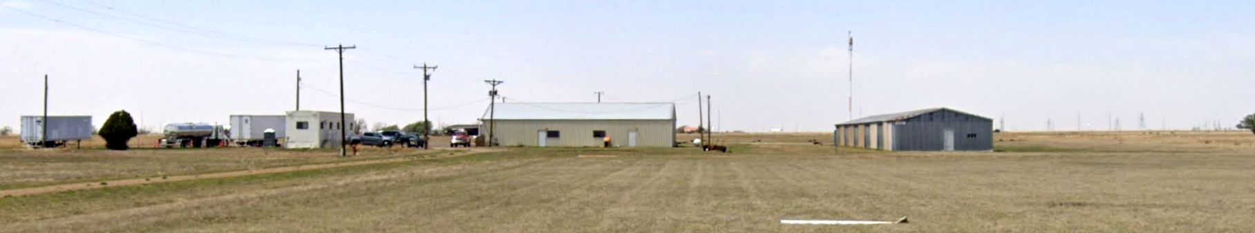
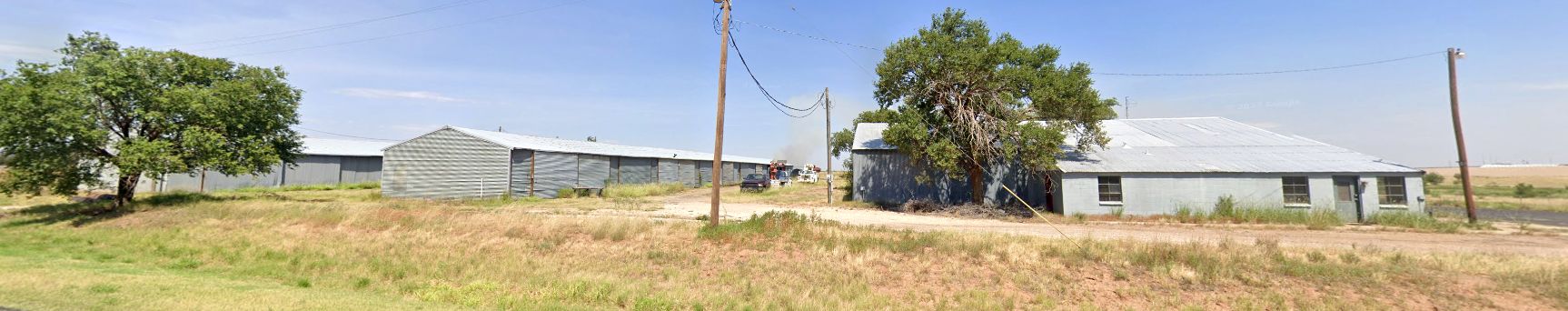
A 2023 photo looking west at former hangars on the east side of the Abernathy Municipal Airport site.
Abernathy Municipal Airport was depicted as an abandoned airfield on the 2024 Sectional Chart (courtesy of Randy Coller).

A 2025 photo by Scott Grissman of a P-51 model aircraft of the Wings Miniature Aircraft Society Club on approach to Abernathy Municipal Airport with the old hangars in the background.
A 2025 photo by Scott Grissman of a the facilities of the Wings Miniature Aircraft Society Club on the northwest side of Abernathy's Runway 17.
Scott Grissman reported, “The Wings Miniature Aircraft Society Club maintains 1,000' of the runway.
The trucking company that was using the airport with us is gone. We are the sole users of the site to date.
Abernathy Municipal Airport is located northwest of the intersection of Route 2600 & Road U.
Thanks to Mike Kmetz for pointing out this airfield.
___________________________________________________
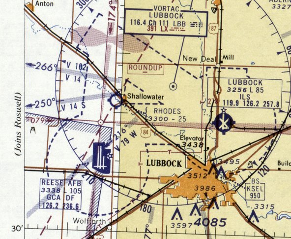
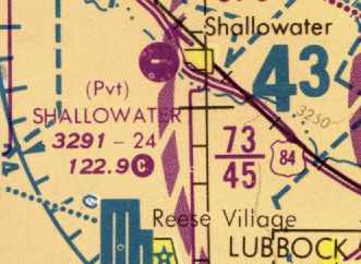
Rhodes Airport / Shallowater Airport, Shallowater, TX
33.68, -102.01 (Northwest of Lubbock, TX)
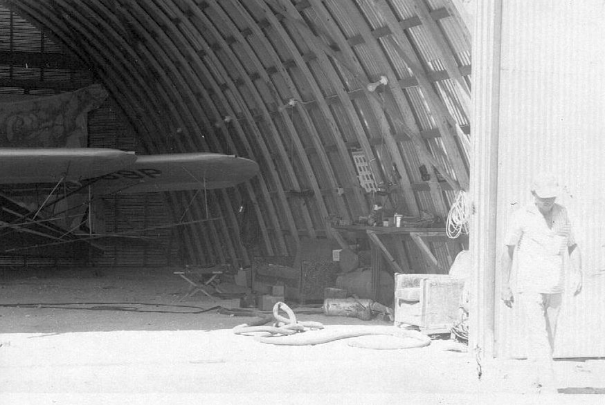
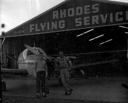
An October 1956 photo of Wendell Rhodes in front of a Rhodes Airport hangar (courtesy of Danny Rhodes).
Danny Rhodes reported that he is “the son of L.W. (Squeaky) Rhodes, owner & operator of Rhodes Flying Service in Shallowater.
Dad was in aviation most all of his life, coming out of the Air Force as a pilot & soon after went into his business aerial dusting, then aerial spraying, instructing, charter etc.
At that time he also built the airport inside the city limits of Shallowater with one single east/west dirt runway.
Then later at the west end of the east/west runway added the north south/dirt runway. They also built T-hangars & a shop at this airport.”
The earliest depiction which has been located of Rhodes Airport was an October 1956 photo of Wendell Rhodes in front of a Rhodes Airport hangar (courtesy of Danny Rhodes).
However, Rhodes Airport was not yet depicted on the January 1957 Dallas Sectional Chart (courtesy of Ron Plante).
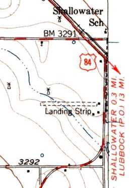
The earliest map depiction which has been located of Rhodes Airport was on the 1957 USGS topo map.
It depicted a single unpaved east/west runway, labeled generically as “Landing Strip”.
Danny Rhodes reported, “About 1957-1958 is when the new highway loop around town was being built & going about half way through the east/west runway.
He [Squeaky Rhodes] then bought & built the airport south of the loop where the remains are at now with 3 rows of T-hangars & a shop hanger.
This airport eventually had 3 runways as shown & the east/west paved [runway] with lights.”
A 1960 photo of Wendell (Squeaky) Rhodes & a Piper Cub in front of a Rhodes Airport hangar (courtesy of Danny Rhodes).
The earliest aeronautical chart depiction of Rhodes Airport which has been located was on the August 1960 Dallas Sectional Chart.
It depicted Rhodes as having a 2,500' unpaved runway.
The 1960 Jeppesen Airway Manual (according to Chris Kennedy) described Rhodes as having 2 unpaved runways, with the longest being 2,500'.
At some point between 1960-62, the field was evidently renamed "Shallowater" Airport,
as that is how it was labeled on the August 1962 Dallas Sectional Chart (courtesy of David Brooks).
It depicted Shallowater as having a 2,800' unpaved runway.
A 1960s photo of Danny & Wendell Rhodes with a Beech Bonaza in front of the Rhodes Flying Service hangar (courtesy of Danny Rhodes).
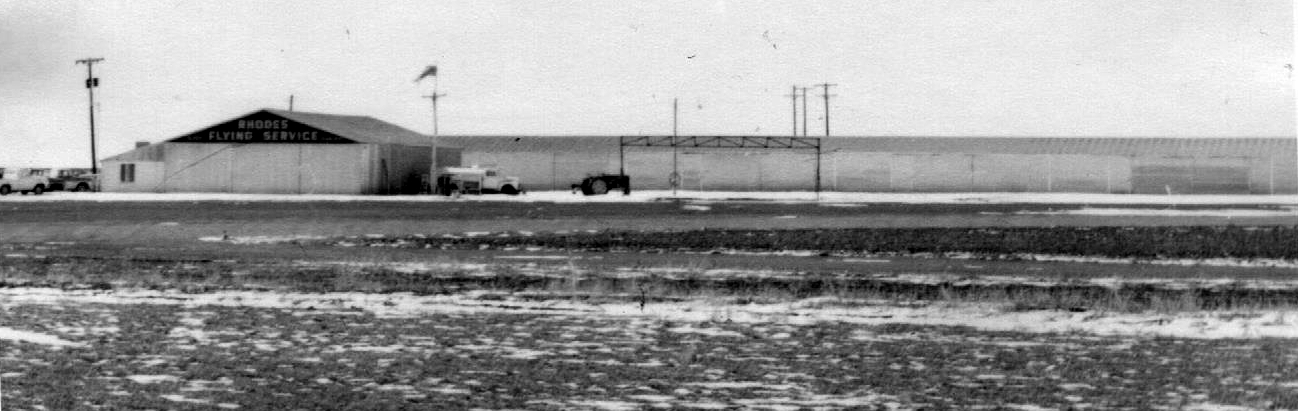
A 1960s photo of the Rhodes Flying Service hangar (courtesy of Danny Rhodes).
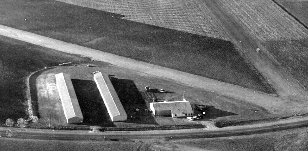
A 1960s aerial view looking north at the Rhodes Airport hangars, and a Beech Bonanza parked outside (courtesy of Danny Rhodes).
A 1960s aerial view looking east at the Rhodes Airport hangars, and the V-tail of the Beech Bonanza just visible beyond the Rhodes Flying Service hangar (courtesy of Danny Rhodes).
According to Danny Rhodes, his father L.W. (Squeaky) Rhodes “owned & operated” Shallowater Airport “until he sold out in January 1966.”
Shallowater apparently gained a paved runway at some point between 1962-68,
as the July 1968 Dallas Sectional Chart (courtesy of Chris Kennedy) depicted the field as having a single 2,400' east/west paved runway.
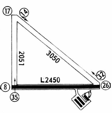
The 1971 Flight Guide (courtesy of David Brooks) depicted Shallowater Airport as having a 2,450' paved Runway 8/26,
along with 2 unpaved runways (3,050' Runway 14/32 & 2,051' Runway 17/35).
Three buildings were depicted on the southeast corner of the field.
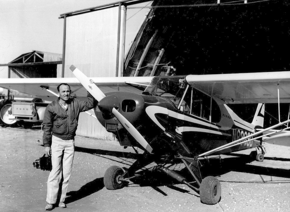
Jon Gravestock recalled, “Shallowater Airport... I worked there as an Airframe & Powerplant mechanic in the summer of 1974.”
A 2/18/77 USGS aerial view depicted Shallowater Airport as having 3 runways & a few small buildings on the southeast side. There were no aircraft visible on the field.
The 1977 Flight Guide (courtesy of David Brooks) showed that the northwestern corner of Shallowater Airport had been 'chopped off' at some point between 1971-77,
shortening the length of Runway 14/32 to 2,700'.
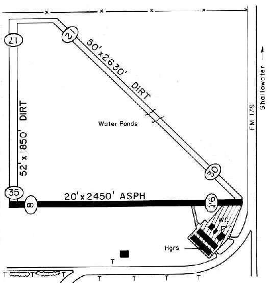
The 1983 TX Airport Directory (courtesy of Chris Kennedy) depicted Shallowater Airport as having a single 2,450' asphalt Runway 8/26
along with a 2,630' dirt Runway 12/30 & a 1,850' dirt Runway 17/35.
A ramp on the southeast corner of the field had 2 long hangars & 3 smaller buildings. The manager was listed as Gary McMillian.
The June 1985 Albuquerque Sectional Chart (courtesy of David Brooks) still depicted Shallowater as a public-use airport.
The status of Shallowater Airport evidently changed to a private airfield at some point between 1985-91,
as that is how it was depicted on the May 1991 Albuquerque Sectional Chart (courtesy of David Brooks).
The field was depicted as having a 2,400' paved runway.
Shallowater Airport was evidently closed (for reasons unknown) at some point between 1991-93,
as it was no longer depicted at all on the May 1993 Albuquerque Sectional Chart (courtesy of Ron Plante).
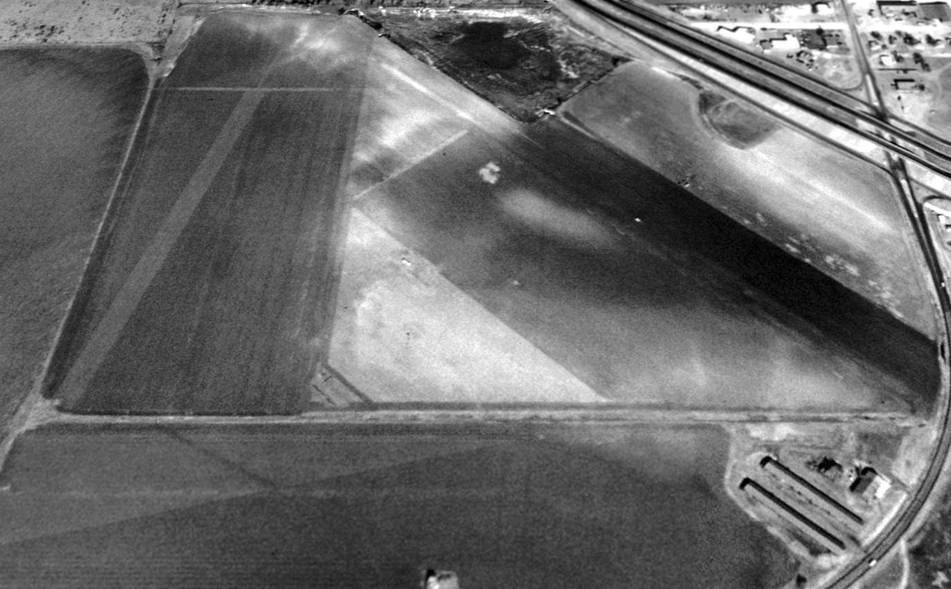
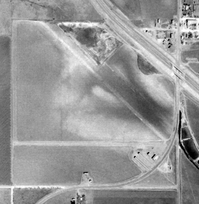
As seen in a 1996 USGS aerial view looking north, Shallowater Airport's runways & hangars were still intact.
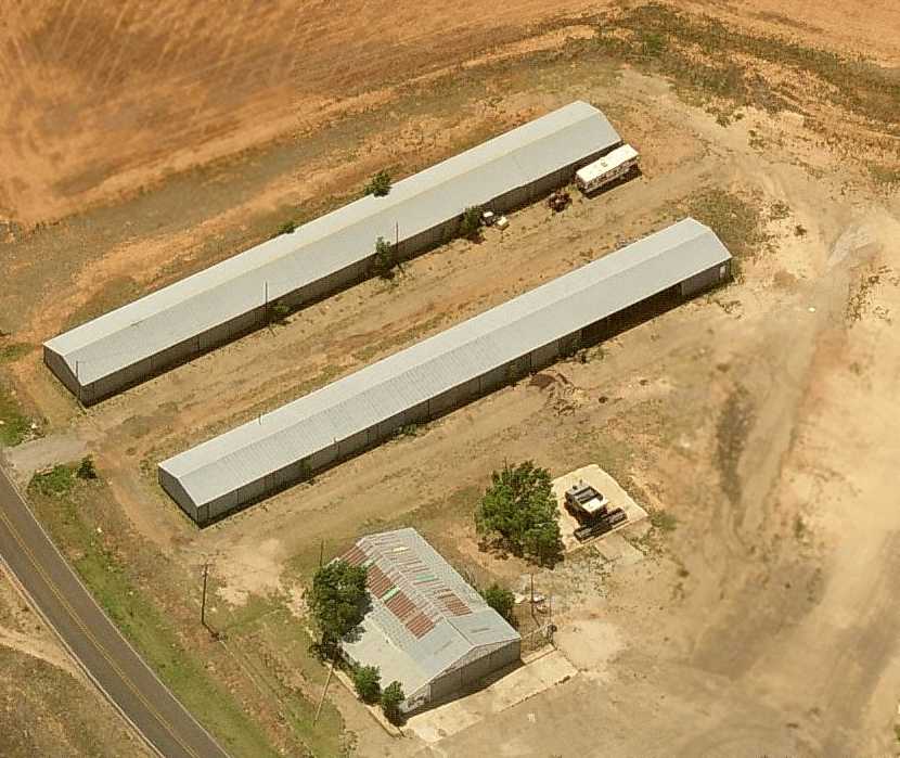
A circa 2006 aerial view looking west at the former hangars at the site of Shallowater Airport.
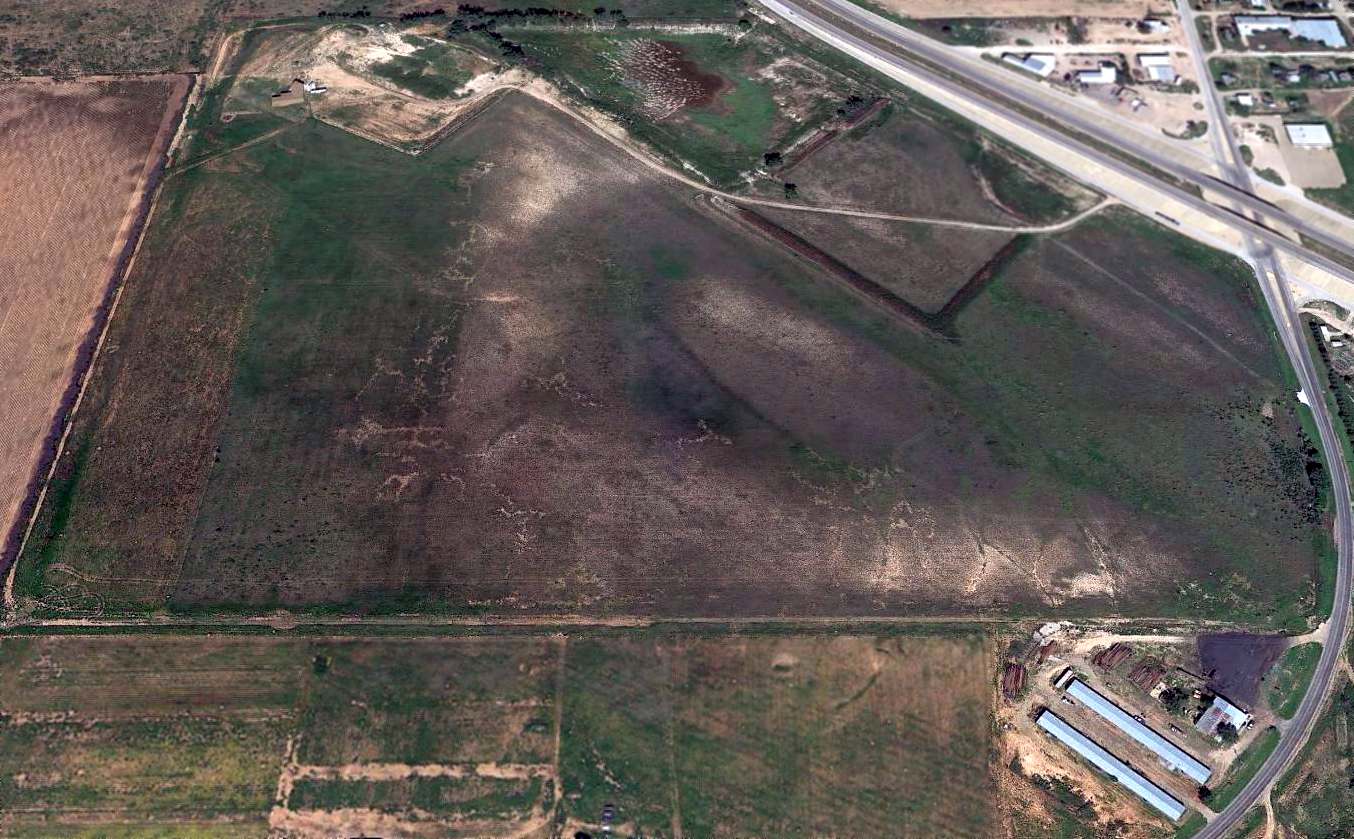
A 2014 aerial view looking north showed that Shallowater Airport's paved east/west runway still remained, along with the hangars at the southeast corner of the the former airport.
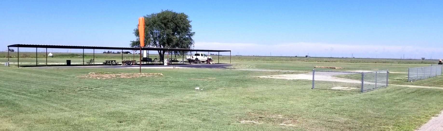
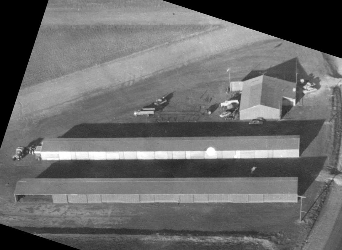
A 2023 photo looking northwest at the former hangars & airport office at the southeast corner of the Shallowater Airport site.
Shallowater Airport is located southwest of the intersection of Route 84 & Avenue E.
___________________________________________________
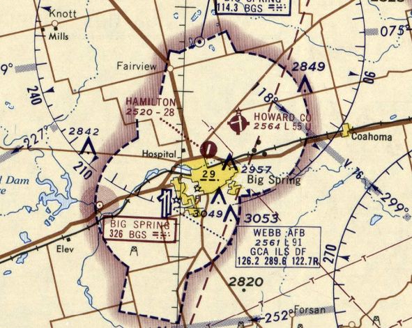
U & S Flying Service Airfield / Hamilton Field, Big Spring, TX
32.27, -101.47 (Southeast of Lubbock, TX)
The "U & S" Flying Service Airfield, as depicted on the March 1944 Dallas Sectional Chart.
Photo of the airfield while open has not been located.
This general aviation airport was evidently constructed at some point between 1943-44,
as it no airfield at this location was yet depicted on the 1942 USGS topo map nor on the February 1943 Dallas Sectional Chart.
The earliest depiction which has been located of the U & S Flying Service Airfield was on the March 1944 Dallas Sectional Chart.
The April 1944 Army/Navy Directory of Airfields (courtesy of Joe Bensen)
described the "U & S Flying Service" Airfield as being located 1.5 miles north of Big Spring,
and the field was said to have a 2,700' unpaved runway.
The 1945 AAF Airfield Directory (courtesy of Scott Murdock) described the “U & S Flying Service Airport”
as a 108 acre irregularly-shaped property having 4 bare runways, the longest being a 3,000' north/south strip.
The field was said to have 2 metal hangars, 76' square & 56' square.
U & S was described as being owned & operated by private interests.
The airfield was evidently renamed "Hamilton Field" at some point between 1945-54,
as that is how it was labeled on the August 1954 Dallas Sectional Chart (courtesy of Chris Kennedy).
It was depicted as having a 3,200' unpaved runway.
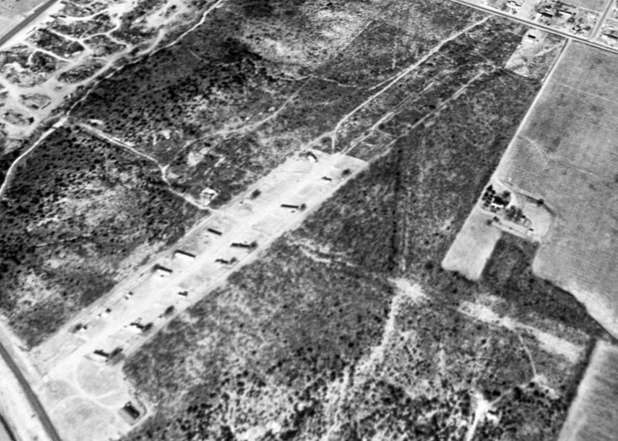
The earliest photo which has been located of Hamilton Field was a 1957 aerial view.
Hamilton Field was seen to have 4 unpaved runways, with a row of hangars & several aircraft along the west side.
The 1962 AOPA Airport Directory described Hamilton Field as having a 2,700' asphalt Runway 18/36 & a 1,850' graded Runway 9/27.
The operator was listed as Hamilton Flying Service.
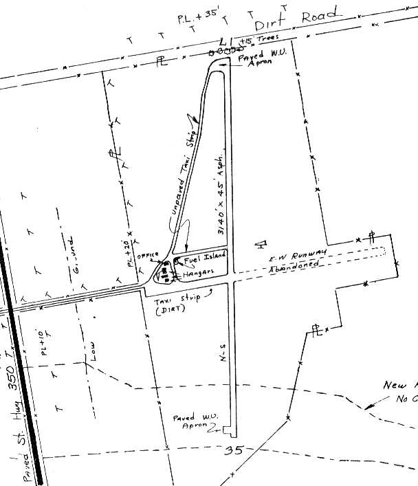
By the time of the 1963 TX Airport Directory (courtesy of Steve Cruse),
Hamilton Field's Runway 18/36 had been lengthened to a 3,140' asphalt strip, but the crosswind runway had been abandoned.
The office, fuel island, and 3 hangars were just north of the west end of the former Runway 9/27.
Ominously, though, the end was in sight for this little airport, as the 1963 Directory depicted a "New Highway Right-Of-Way, No construction this date"
passing along the southern portion of Runway 18/36.
This would eventually become Interstate 20, and would spell the end of the airport.
A 2/20/65 USGS aerial view depicted Hamilton Field possibly after its closure.
Hamilton Field was seen to have 3 unpaved runways, but the southern end of the primary runway was truncated by the new Interstate 20.
A row of small hangars was along the west side, but no aircraft were visible on the field.
The last aeronautical chart depiction which has been located of Hamilton Field was on the February 1966 Dallas Sectional Chart.
It depicted Hamilton as having a single 2,800' paved northeast/southwest runway.
Hamilton Field was evidently closed at some point between 1966-68,
as it was no longer depicted on the 1968 Dallas Sectional Chart.
Interstate 20 was depicted on the 1975 USGS topo map, but not the airport.
The 1978 USGS topo map still depicted a single north/south runway, but did not label the site as an airfield.
A 1996 USGS aerial view looking northwest at Hamilton Field showed the remains of both runways were still very much apparent.
The middle portion the remains of Runway 18/36 was apparently being reused as a road, along which what appeared to be several mobile homes were situated.
A 2015 aerial view looking northwest showed the remains of Hamilton Field's paved Runway 17/35 was still quite recognizable.
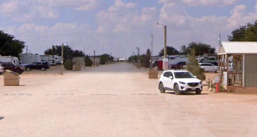
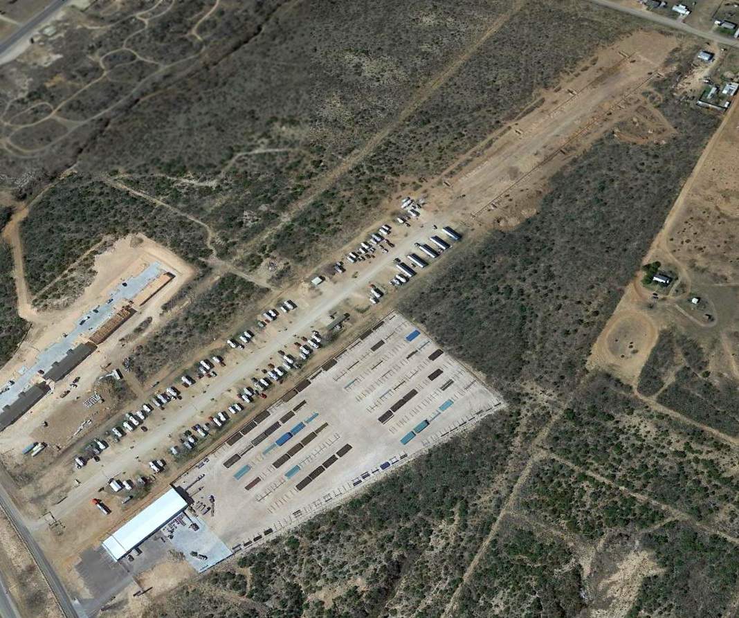
A 2022 photo looking north along the remains of Hamilton Field's Runway 35, reused as an RV park.
As of 2023, street maps labeled the Hamilton Field site as the Southridge RV Park in Big Spring.
The site of Hamilton Field is located northeast of the intersection of Interstate 20 & Route 350.
____________________________________________________
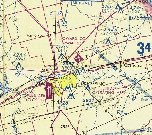
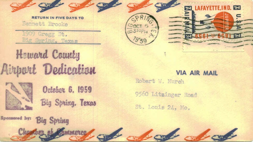
Howard County Municipal Airport, Big Spring, TX
32.31, -101.44 (Southeast of Lubbock, TX)
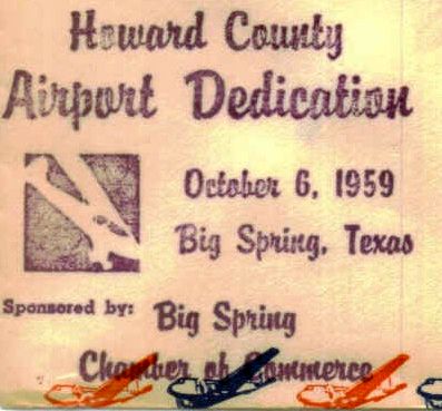
A postmark commemorated the 10/6/59 Howard County Airport Dedication.
The Howard County Airport was not yet depicted on the August 1954 Dallas Sectional Chart (courtesy of Chris Kennedy).
A postmark commemorated the 10/6/59 Howard County Airport Dedication.
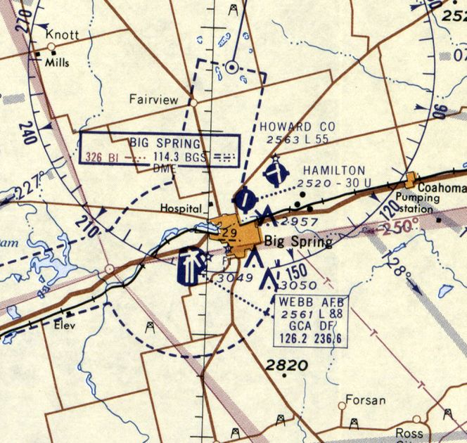
The earliest depiction which has been located of Howard County Airport was on the August 1960 Dallas Sectional Chart.
It depicted Howard County Airport as having 2 paved runways, with the longest being 5,500'.
The earliest directory listing which has been located of the Howard County Airport was in the 1962 AOPA Airport Directory.
It described Howard County as having 2 paved runways, and listed the operator as Big Spring Aircraft Inc.
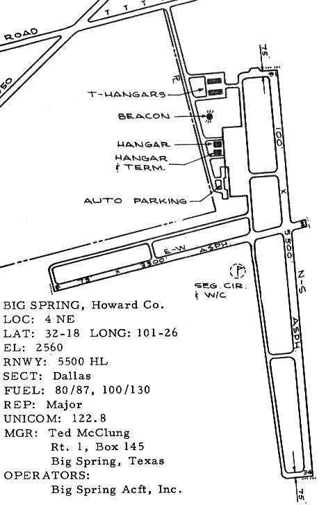
The 1963 TX Airport Directory (courtesy of Steve Cruse)
described Howard County Airport as having 2 asphalt runways: 5,500' Runway 16/34 & 3,500' Runway 6/24.
According to Scott Murdock, the Air Force based T-41s from Webb AFB at Howard County, and conducted the T-41 phase of training here.
Michael Moore recalled, “The checkered control tower at Howard County Airport:
“It was used as a control/observation tower for the USAF T-41 program & the occupants were instructors or military supervisory personnel.
At each program there would be a major & 2 captains supervising the civilian management.
Occupants of the tower could not legally direct traffic per se, but could give out advisories to inbound & outbound traffic,
including the Trans Texas flights that came in there twice daily & mixed with the T-41 aircraft.
It was also used to tell students to return to the field due to deteriorating weather conditions,
or to advise them of dangerous situations developing in the traffic pattern & such things.
The hangar beside the tower was the headquarters for that program
with a classroom for a morning class & an afternoon class with approximately 20-25 instructors with 2 maintenance people.
The T-41 program military supervisors served as check pilots on elimination rides but all the instructors were civilian working for a contractor called Bell Flying Service.
It was an active place.”
John Wiley recalled, “We used Howard County for our T-41 training in 1967.
I was in Class 69-04, the Dust Devils, and we flew our first UPT sorties out of Howard County.
It was run by a company the USAF had hired
and with the exception of a few instructors, all were civilians.
We lost more than a few guys in the first 6 weeks flying the 'washing machine'.”
“When I arrived on 12/7/67 we landed in a Trans-Texas Convair with turboprops.
It was cold as hell & before we had hit the ground,
the crew had shut down the Convair, turned off all the switches & were GONE.
I was standing there with my new uniform, my garrison hat & a brand new set of brown bars.
I got a ride to Webb & spent the first night in the BOQ.
My instructor was a guy named Major Hamela, great guy & good aviator.
Our class had a couple of Iranians, a few Saudi & 2 Marines
along with a mixture of philosophy, theology, engineering, English lit, music & business majors.
We graduated in December 1968, and by March, we had lost our first guy, one of the Marines in an A-4.
It would not be the last.”
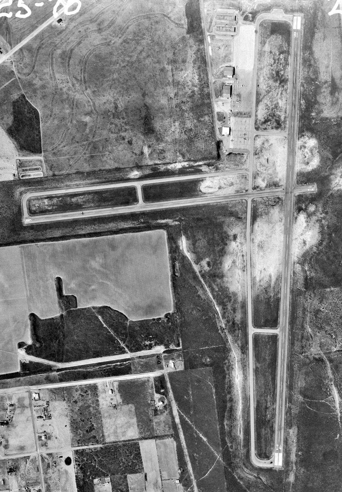
The earliest photo which has been located of Howard County Airport was a 2/25/70 USGS aerial view.
It depicted Howard County Airport as having 2 paved runways with parallel taxiways, and several buildings on the northwest ramp.
A total of 17 single-engine aircraft were visible, including what appears to be an F-86 Sabre jet fighter on static display on the grass northeast of the ramp.
The 1971 USGS topo map depicted Howard County Airport as having 2 paved runways with parallel taxiways, and several buildings on the northwest ramp.
The much larger nearby Webb AFB closed in 1977, becoming Big Spring Airport.
According to M. Moore, the Air Force T-41 flight training program at Howard County “was shut down when Webb Air Force Base shut down.”
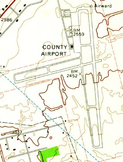
Howard County Airport, as depicted on the 1978 USGS topo map.
The last aeronautical chart depiction which has been located of Howard County Airport was on the 1978 DFW Sectional Chart (courtesy of Ray Brindle).
It depicted Howard County Airport as having 2 paved runways, with the longest being 5,500'.
Howard County Airport was apparently closed at some point between 1978-85,
as it is not included among active airports in the 1985 TX Airport Directory,
and it was not even depicted at all on the 1985 USGS topo map.
A 1996 USGS aerial view looking southeast showed Howard County Airport to have 2 runways, taxiways, a ramp & several hangars.
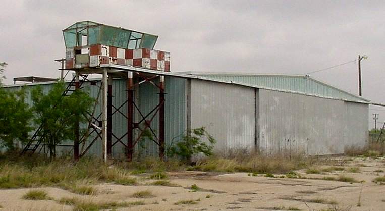
A 2002 photo by Scott Murdock of the southern-most hangar with attached control tower at Howard Municipal,
leftover from its Air Force T-41 flight training days.
As of 2002, the Howard County Airport property was mostly abandoned, with some usage by a few industrial businesses & some RC model airplane activity.
A 2015 aerial view looking southeast at Howard County Airport showed that this extensive airfield still remained completely intact -
a shame to see so much aviation infrastructure not being put to any aviation use.

Amazingly a 2024 photo looking northeast shows the former Howard Municipal Airport Air Force control tower remains standing, looking like a scene out of a zombie show.
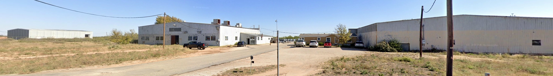
A 2024 photo looking northeast at the row of former Howard Municipal Airport hangars – a lot of infrastructure no longer serving any aviation purpose.
Appropriately enough, the Howard County Airport site is located at the end of Airport Road, south of Old Airport Road (Route 26).
____________________________________________________
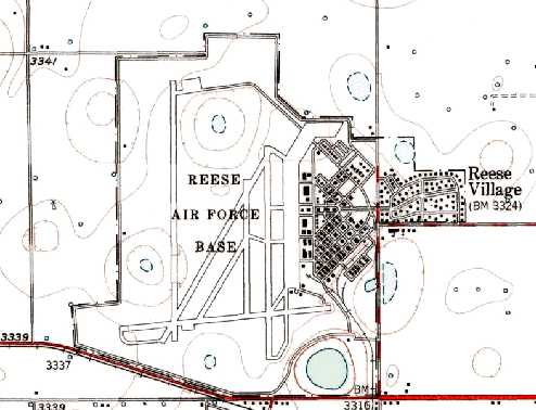
Lubbock Army Airfield / Reese AFB, Lubbock TX
33.62, -102.06 (Northwest of Downtown Lubbock, TX)
A 1942 aerial view looking northeast at the Lubbock Army Flying School.
Lubbock Army Airfield was not yet depicted on the August 1941 Dallas Sectional Chart.
According to The Handbook of TX Online, this base was built in 1941 on 2,000 acres that were offered by the City of Lubbock.
Cotton fields & grassland gave way to a huge military installation when construction began on 8/22/41.
Initial construction of the base only took 5 months, and Lubbock Field officially opened on 1/22/42.
It was originally known as the Lubbock Army Air Corps Advanced Flying School.
It offered primary flight training to cadets & instrument training for pilots.
The earliest depiction which has been located of Lubbock Field was a 1942 aerial view looking northeast.
It depicted the field as having 3 paved runways, with a massive concrete ramp on the east side,
and a large number of buildings to the east.
The base was renamed to the Lubbock Army Flying School in early 1943,
and then to Lubbock Army Airfield later that year.
Aircraft flown from the base during WW2 included the T-6 Texan, AT-17 Bobcat, and AT-9 Jeep.
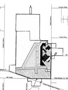
A 1943 Army Corps of Engineers plan of Lubbock AAF (courtesy of Rex Ricks),
showing the original WW2 airfield configuration of 3 runways.
The earliest aeronautical chart depiction which has been located of Lubbock AAF was on the February 1943 Dallas Sectional Chart.
During WW2, Lubbock AAF had a total of 5 satellite airfields: West Aux #1 (24 miles west of Lubbock), of which no trace has been identified,
South Aux #2 (33 miles West-Southwest of Lubbock), North Aux #3 (12 miles NW of Reese AFB), of which no trace has been identified,
Opdyke Aux #4 (4 miles east of Opdyke), of which no trace has been identified,
and Abernathy Aux (5 miles ENE of Abernathy, still reused as Abernathy Municipal Airport).
The 1945 AAF Airfield Directory (courtesy of Scott Murdock) described Lubbock AAF
as a 1,631 acre rectangular property having 3 asphalt 6,500' runways, oriented north/south, east/west, and northeast/southwest.
The field was said to have 3 metal hangars, measuring 184' x 100'.
Lubbock AAF was described as being owned by the City of Lubbock & operated by the Army Air Forces.
The complement of auxiliary airfields was listed as: #1 West Field, #2 South Field, #3 North Field, and #4 Abernathy Field.
However, the title of Lubbock AAF's listing indicated the field was “Inactive”.
Lubbock AAF was closed at the end of 1945, after graduating 7,009 pilots.
In the post-WW2 years, the base was reportedly used as a meeting place for National Guard, Air Reserve, and Naval Reserve units.
Lubbock was reactivated by the Air Force in 1949 as a multiengine pilot-training base.
It was named Lubbock Air Force Base, until being renamed Reese Air Force Base in late 1949.
The main aircraft used at Reese during this period was the TB-25 Mitchell bomber,
which was used to train student officers & aviation cadets.
An Army Corps of Engineers Environmental Impact Statement (courtesy of Rex Ricks)
stated, “The North American TB-25 Mitchell was the basic training aircraft from 1949-59.”
A 1949 aerial view looking west at Lubbock AFB.
The AT-6 Texan was also used starting in 1949 to augment multi-engine pilot training.
The last AT-6 training mission took place at Lubbock on 5/19/53.
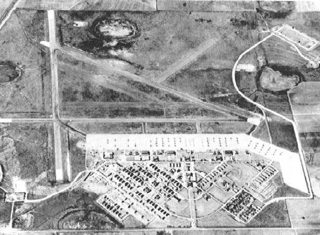
A 7/20/54 USGS aerial view depicted Reese AFB while construction was underway for a 2nd north/south runway,
presumably to support jet operations.
A closeup from the 7/20/54 USGS aerial view, showing an amazing number of aircraft packed onto Reese AFB's ramp.
The 1957 USGS topo map depicted Reese AFB with its new 2nd north/south runway.
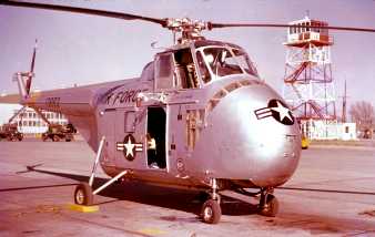
A 1957 photo by Bill Lyster of a Sikorsky H-19A (51-3893) at Reese AFB.
The TB-25 was used at Reese until the base was converted to single-engine jet training in 1959.
The last TB-25 to fly at Reese was placed on static display at the main entrance to the base.
The T-33, a single-engine jet, was the only training aircraft at Reese from January 1959 until the T-37 arrived in March 1961.
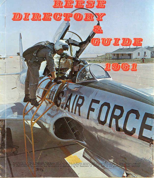
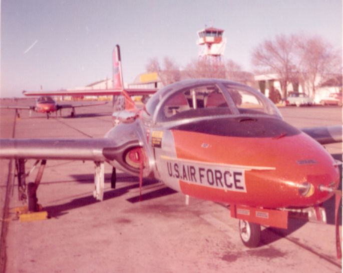
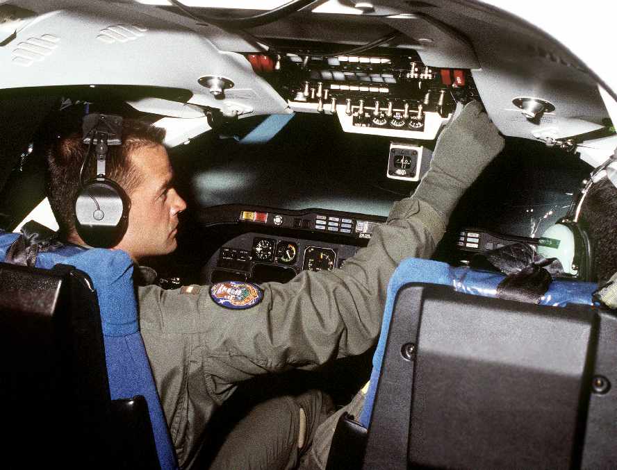
An undated photo on the cover of the 1961 Reese AFB Directory & Guide (courtesy of Mike Kmetz),
showing a crew entering a Lockheed T-33 Shooting Star.
An Army Corps of Engineers Environmental Impact Statement (courtesy of Rex Ricks) stated,
“By 1962, Reese AFB had expanded to the west, north, and east.
A 3rd north/south runway (the primary instrument runway) had been constructed.
Remnants of the original 3 runways remained, and may have been used on occasion.”
The supersonic T-38 was used at Reese starting in 1963
to permit qualification of pilots for quicker transition to larger & faster aircraft.
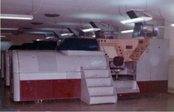
A March 1963 photo by Mike Kmetz of a Link C-11 Instrument Flight Trainer (a simulator of the Lockheed T-33) at Reese AFB.
Mike recalled, the photo is “from my 2 years as an instrument flight instructor at Reese AFB.
How things have changed. Those old simulators were analog systems powered by vacuum tube amplifiers & servomechanisms.
They could easily drift out of alignment, but they managed to get the job done. Primitive by today’s standards.
The Link C-11 instrument flight trainer was used for T-33 jet training. They were being phased out as the T-38s were arriving in 1963.
I worked in T-37 training on the Link T4 IFTs. We even had one original Link ME-1 IFT from 1955 – very similar to the T4.”
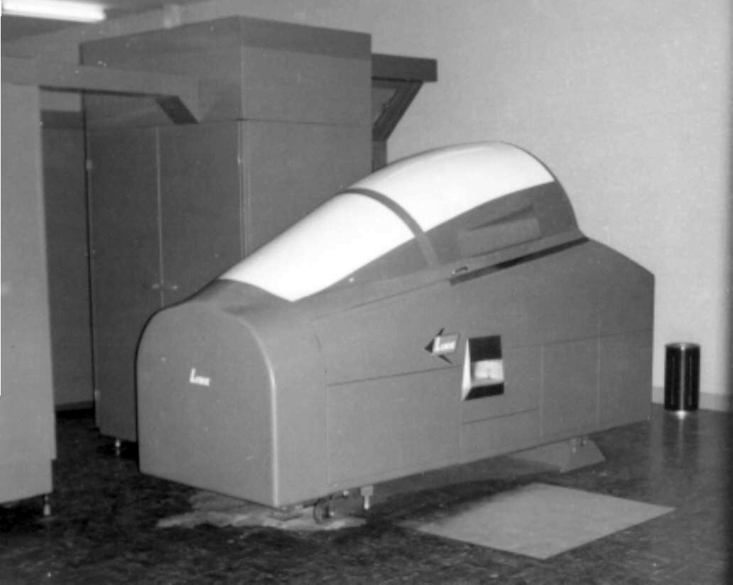
A March 1963 photo by Mike Kmetz of a Link T-7 Instrument Flight Trainer (a simulator of the Northrop T-38) at Reese AFB.
Mike recalled, “The T7 IFTs (for T-38 training) were just being installed in the new high-bay building as I was getting ready to depart.
The T7s were still not equipped with motion systems. They did have a limited vertical motion device to give onset to stall warning, but that was it.”
A March 1963 photo by Mike Kmetz of Lockheed T-33 Shooting Stars, “ready to retire”, at Reese AFB.
Mike recalled, “Those West Texas dust storms were something awful. We would see planes return with all the international orange paint sandblasted off the leading edges.”
A March 1963 photo by Mike Kmetz of Cessna T-37s at Reese AFB.
A March 1963 photo by Mike Kmetz of new Northrop T-38 Talons at Reese AFB.
From March 1965 to June 1973, a military version of the Cessna 172, the T-41, was used at Reese.
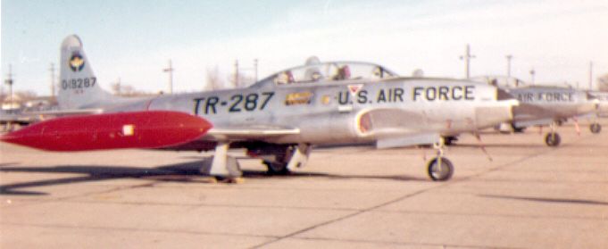
Reese AFB, as depicted on the 1966 Roswell Sectional Chart (courtesy of John Voss).
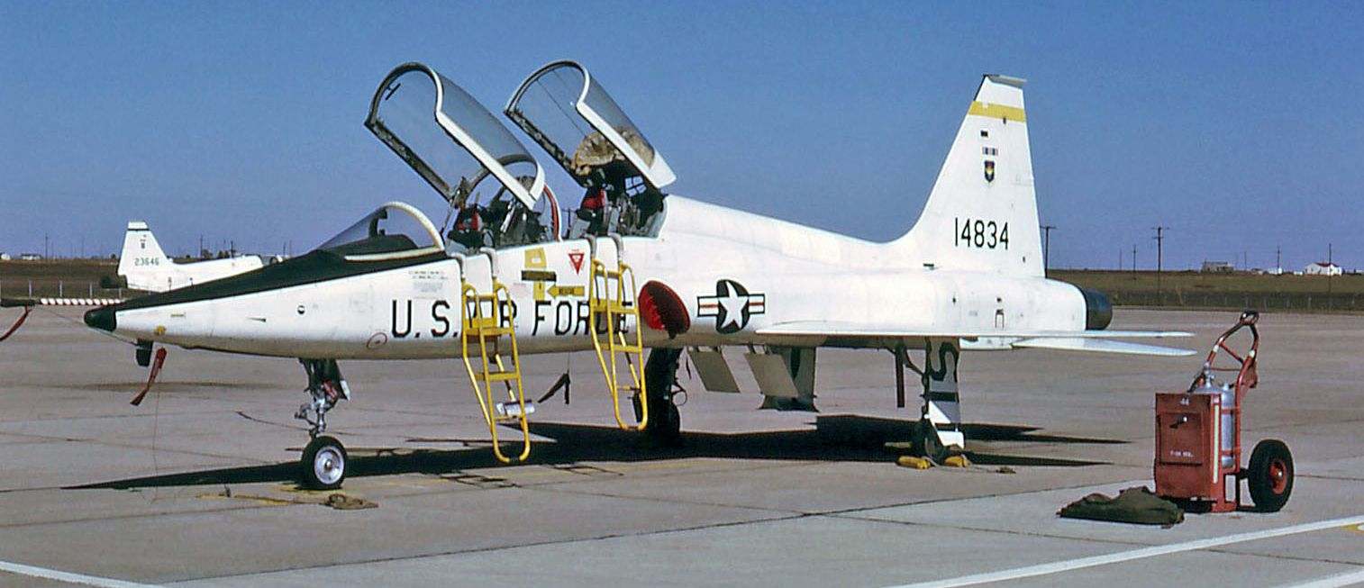
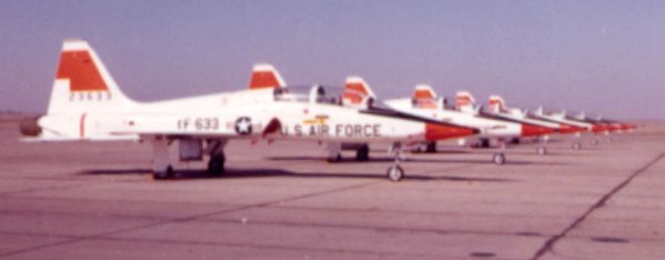
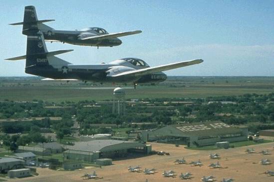
A 10/20/75 photo of pretty Northrop T-38A Talon C/n T0630 67-14834 at Reese AFB.
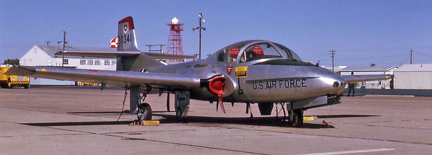
A 10/20/75 photo of bare-metal Cessna T-37B Tweety Bird C/n 40503 59-0341 at Reese AFB.
Reese began using its first Operational Instrument Flight Simulator in August 1977.
The base became a focal point for national media in 1979 when the Crown Prince Of Iran began his military flight training at Reese.
His residence in the South Plains was cut short several months later, however, with the deposition of his father, The Shah Of Iran.
The Crown Prince, as a security measure, was returned to his homeland under cover of night.
Reese AFB was also home to the very first female USAF pilot trainees in the late 1970s.
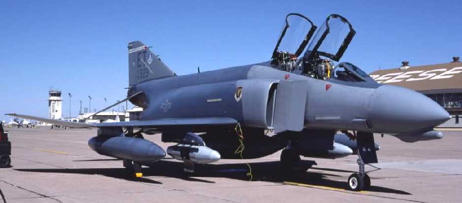
A circa 1980s photo by Gerald McMasters of the very 1st F-4D built (64-0929) transient at Reese AFB.
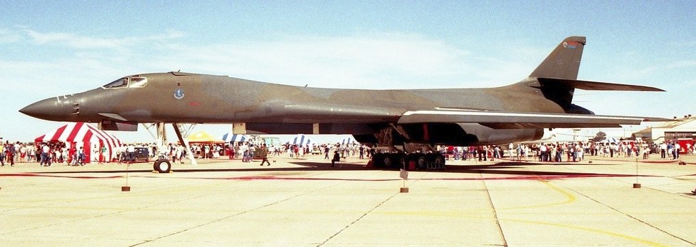
A 3/25/89 photo of a Rockwell B-1B bomber at Reese AFB during an open house.

A 3/25/89 photo of a Northrop T-38A Talon mounted on a pylon at Reese AFB.
The T-1A Jayhawk, the first new training aircraft to be added to the U.S. Air Force inventory in 30 years, arrived at Reese on 1/18/92.

The last aeronautical chart depiction which has been located of Reese AFB was on the May 1993 Albuquerque Sectional Chart (courtesy of Ron Plante).
It depicted Reese as having 3 parallel paved runways, with the longest being 10,500'.
A circa 1990s photo of a T-37, T-1, and T-38 in front of a Reese hangar.
During its last decade (the 1990s), Reese conducted Specialized Undergraduate Pilot Training,
using a complement of 200 aircraft (the T-37, T-38, and T-1).
In 1995 the Base Realignment And Closure Commission designated Reese for closure, to be carried out in another 2 years.
A 5/17/96 DoD photo by Bill Allen of a naval student's preflight check
in a T-1A Operational Flight Trainer (flight simulator) at Reese AFB.
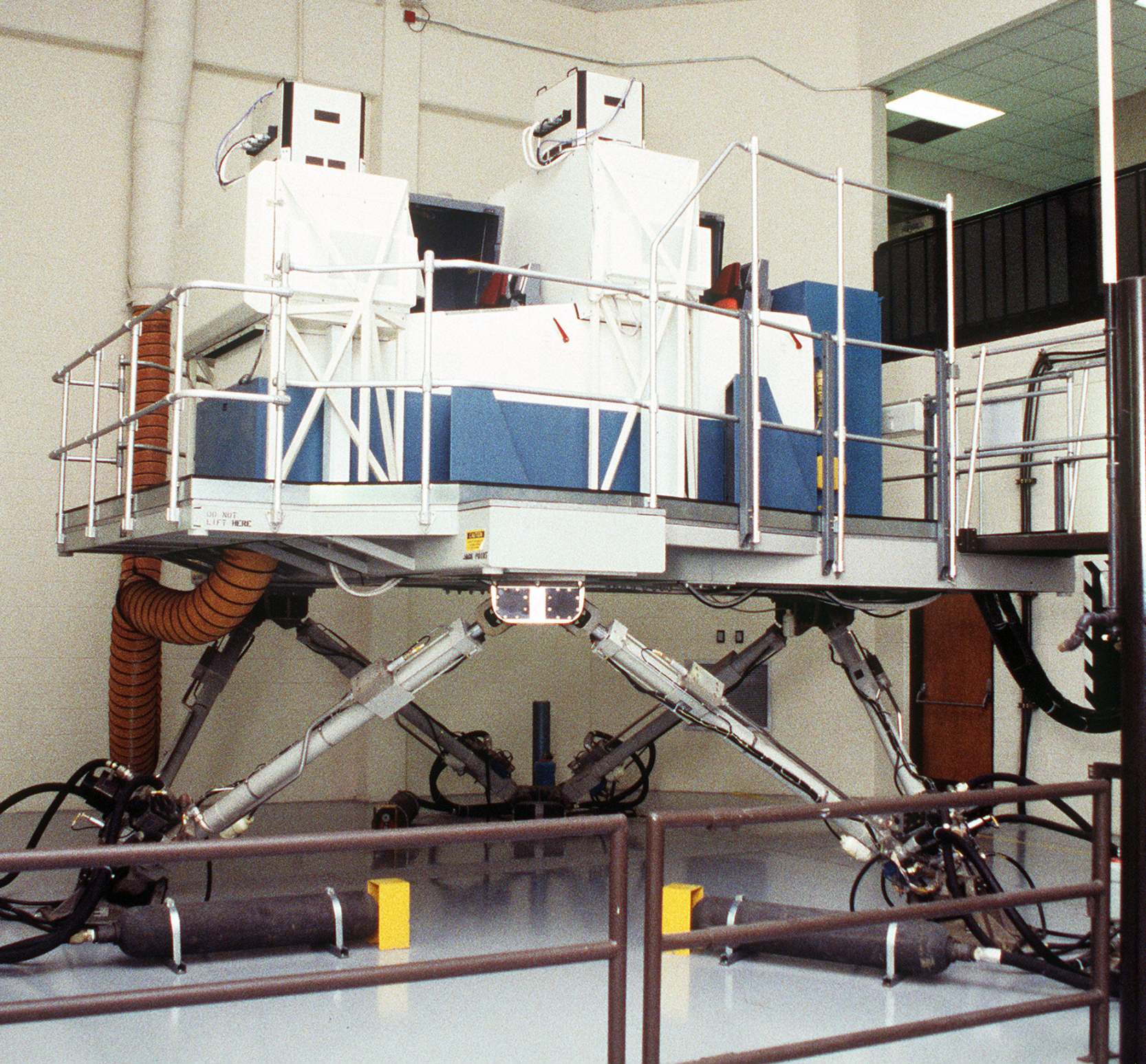
A 5/17/96 DoD photo by Bill Allen of the exterior of a T-38 Talon full motion flight simulator inside a Reese AFB highbay.
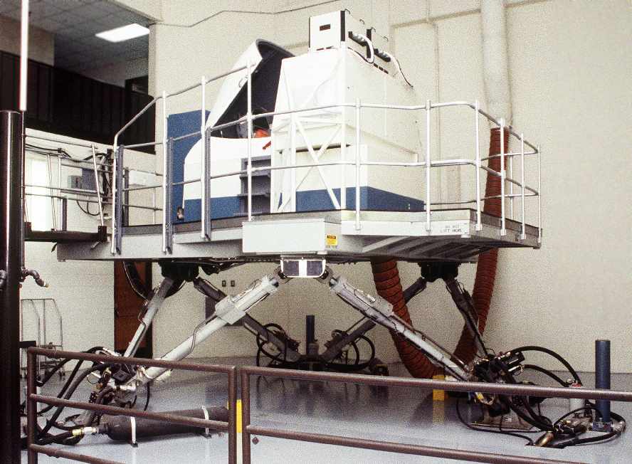
A 6/20/96 DoD photo by Bill Allen of the exterior of a T-37 Operational Flight Trainer (flight simulator) inside a Reese AFB highbay.
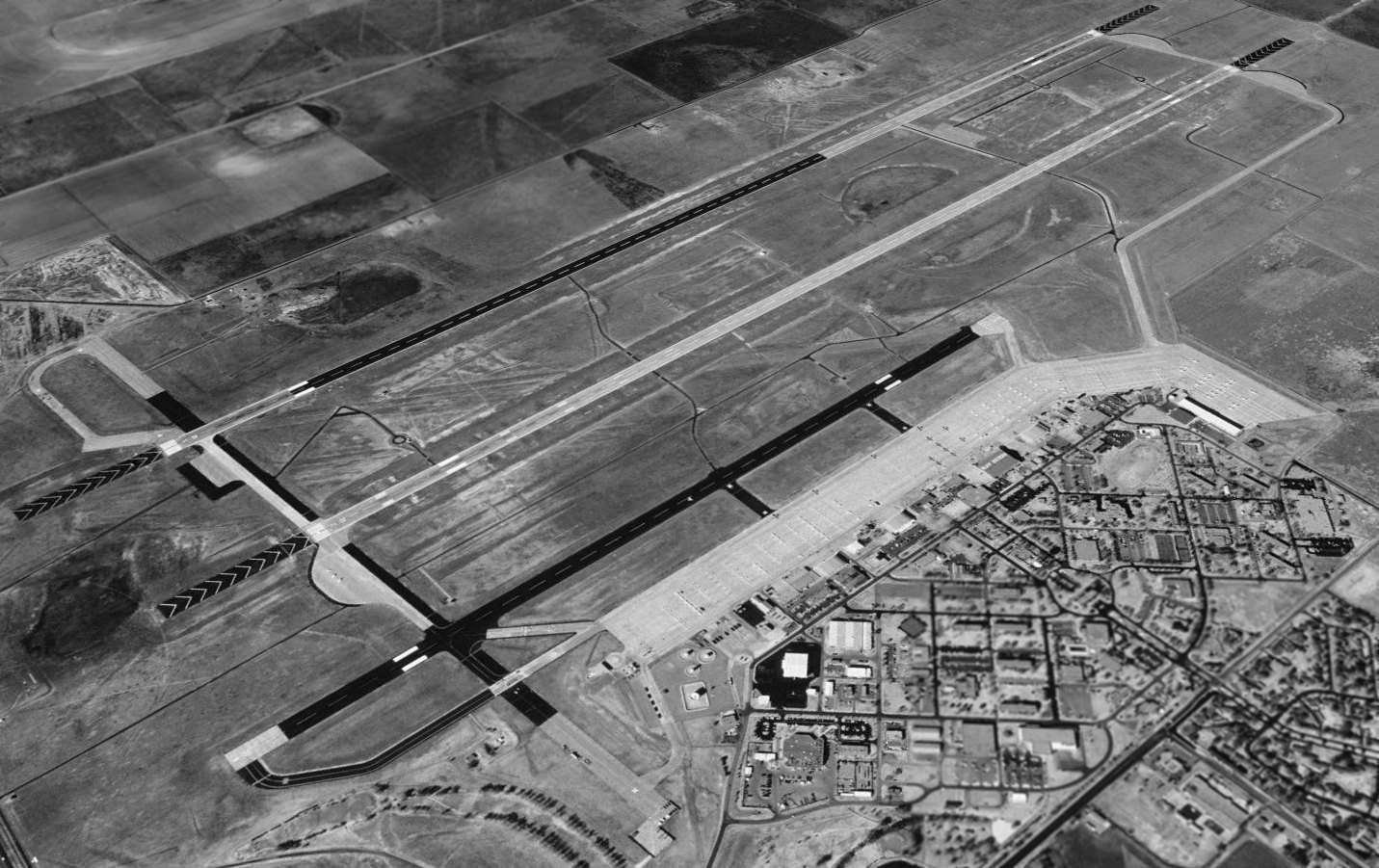
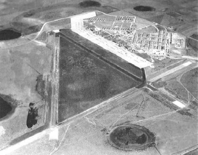
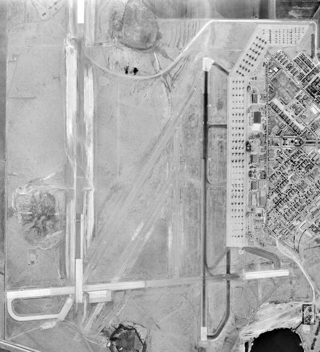
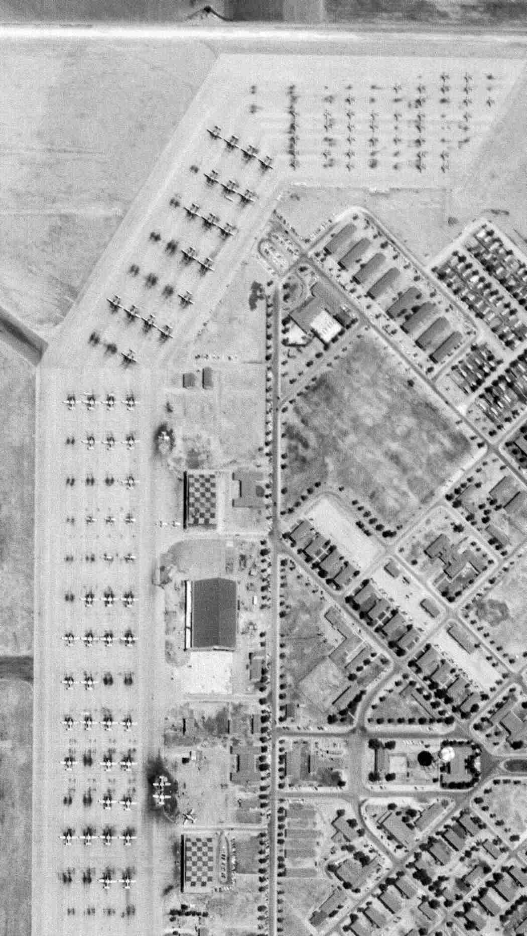
A 1996 USGS aerial view looking northwest depicted Reese AFB while still active.
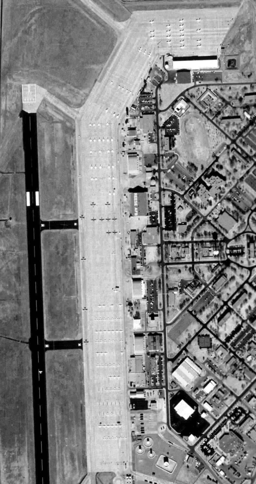
A closeup from the 1996 USGS aerial photo, showing over a hundred T-38s, T-37s, and T-1s on the Reese AFB ramp.
T-37 jet trainers overfly a ramp filled with T-38s, while Reese was still active.
Reese was closed in 1997 as part of the Base Realignment and Closure Commission process.
In its history, Reese trained a total of 25,349 pilots.
At the time of its closure, the base consisted of a total of 3,000 acres, with some 700 buildings.
The airfield consisted of 3 North/South runways (the largest is 10,500' long), 2 former crosswind runways, and large ramp areas & numerous large hangars.
Ulrich Neumann recalled, “I am a glider pilot & was part of what may have been the last aviation-related activity of the former Reese AFB.
In 2002, the Sports-Class & 18m-Class National Contest was held at Reese AFB.
A total of around 80 gliders competed over a 2 week period.
It was an unforgettable experience, since most of us had never flown off such a huge airfield.
We used to main runway to stage the gliders in a single file on the left side of the runway & still had plenty room for the tow-planes to land on the right side.
For landing, we used the 'short' runway closer to the ramp & the operations building.
Our daily briefings took place in the theater complex & one of the banquets was held in the fire station.
The entire compound looked like it had just been abandoned.”
The local government worked to redevelop Reese for civilian businesses, as the Reese Technology Center.
It had a variety of tenants, including the Texas Tech University, a police training center, and South Plains College.
As of 2004, Reese Airpark (8XS8) was listed as a private airfield owned by the Lubbock Reese Development Authority.
A 2005 aerial photo showed thousands of objects (containers?) stored all over Reese's former runways, taxiways, and ramps.
There was no sign of any aircraft on the field.
It also showed that all of the former housing on the east side of the base had been leveled – with nothing to replace it – a very strange sight.
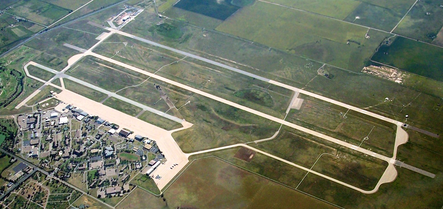
An 8/23/10 aerial view looking southwest at the massive former Reese AFB airfield complex, showing not a single aircraft on the ramp.
As of 2013, Reese Airpark was still being marketed for commercial redevelopment.
The airfield remained listed as a private airfield, but did not have a Fixed-Base Operator.
A 2015 aerial view looking east at the Reese AFB ramp, with no aircraft visible.
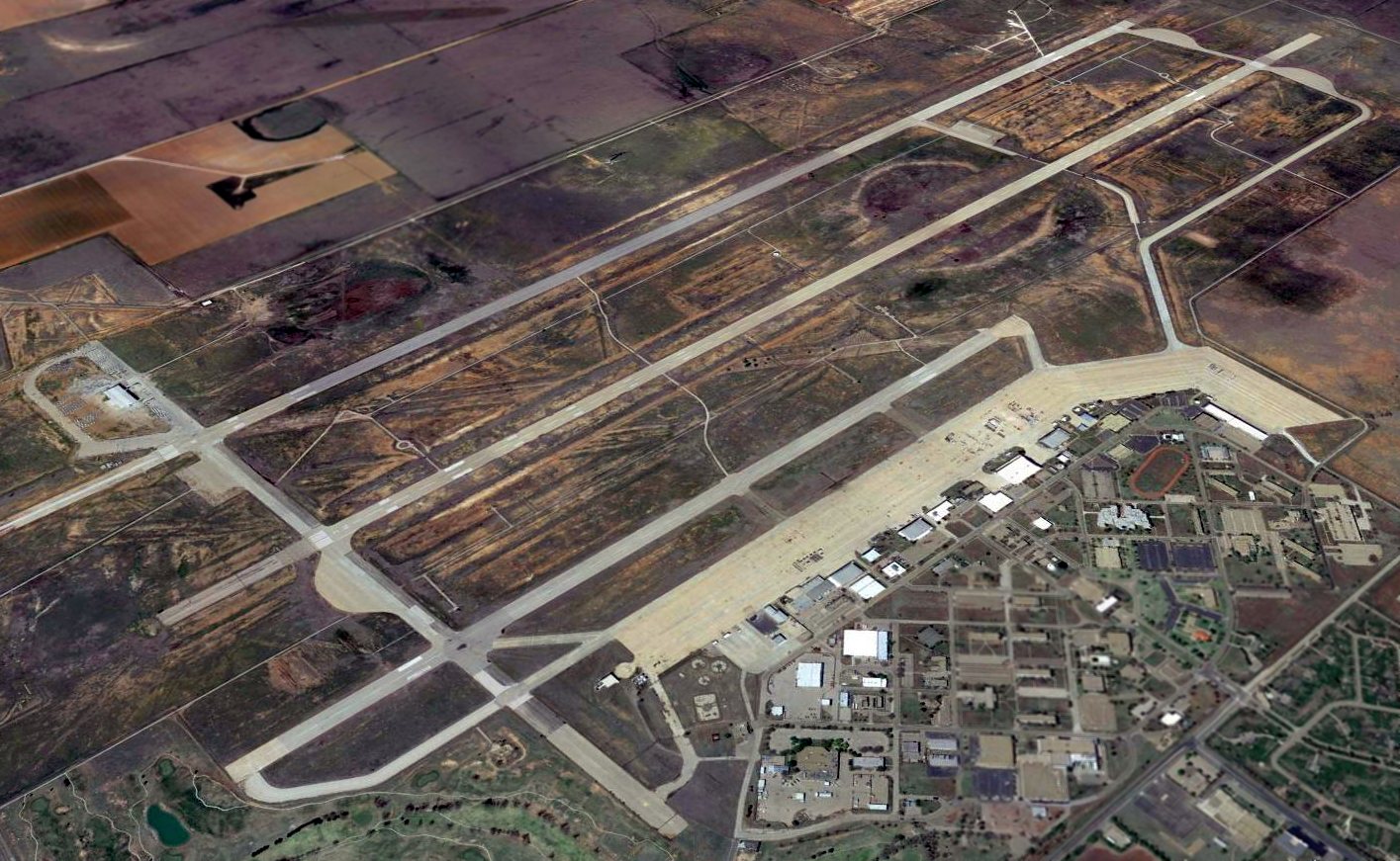
A 2016 aerial view looking northwest at the massive former Reese AFB airfield complex.
Not a single aircraft appears anywhere on the huge airfield - a sad sight.

A May 2024 photo by Mike Legeros of a Reese AFB historical sign.

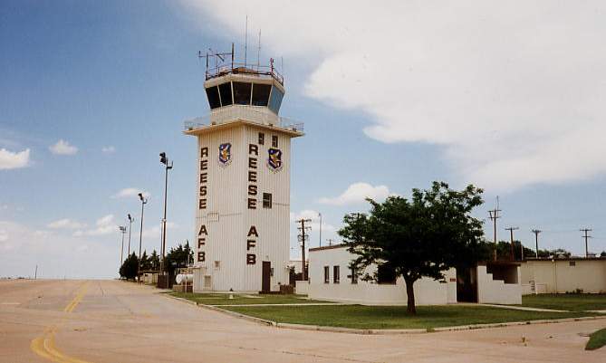
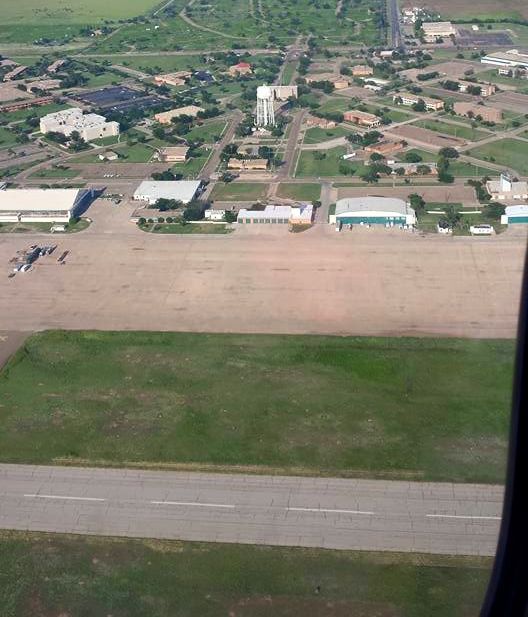
A May 2024 photo by Mike Legeros of the abandoned Reese AFB control tower.

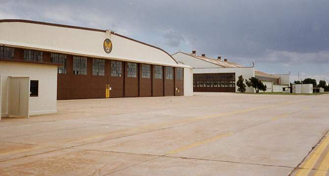
A May 2024 photo by Mike Legeros of a former Reese AFB hangar.
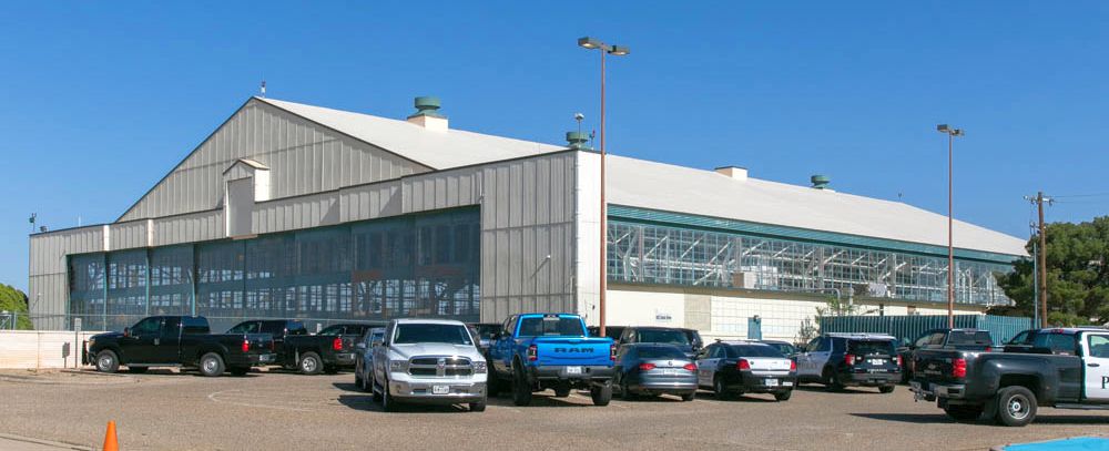
A May 2024 photo by Mike Legeros of a former Reese AFB hangar.
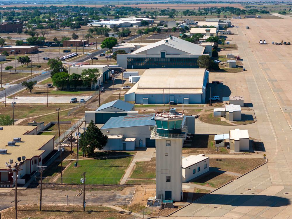
A May 2024 drone aerial view by Mike Legeros looking south at the abandoned Reese AFB control tower & former hangars.

A May 2024 drone aerial view by Mike Legeros looking southwest at the abandoned Reese AFB control tower & former hangars.

A May 2024 drone aerial view by Mike Legeros looking southeast at the former Reese AFB ramp & hangars.
See also: Lou Thole's "Forgotten Fields of America", Volume III.
____________________________________________________
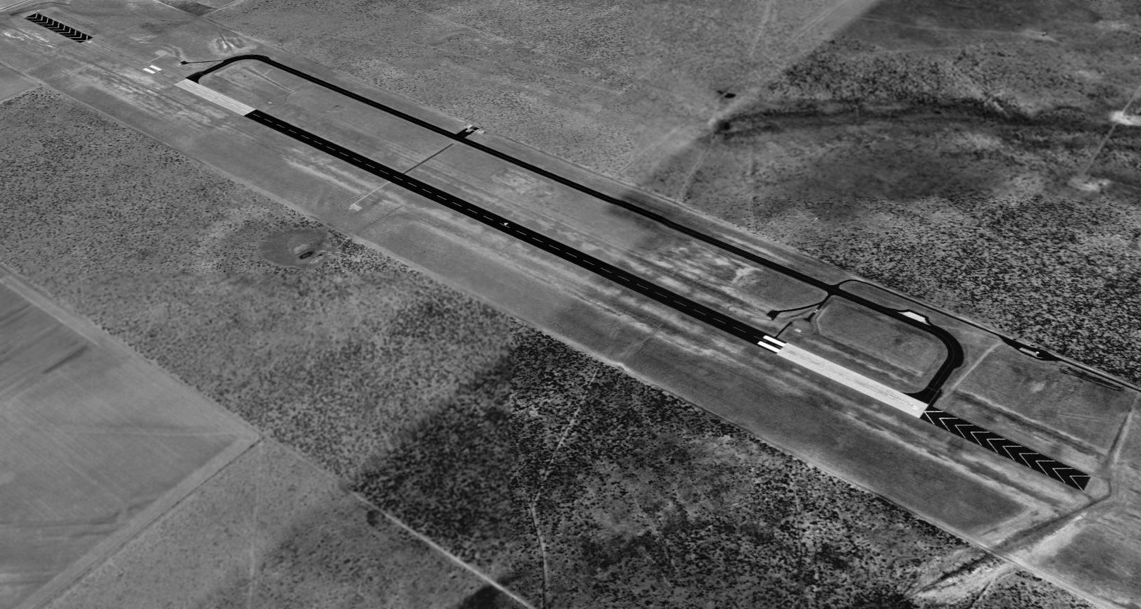
Terry County Air Force Auxiliary Airfield / Reese Air Force Auxiliary Airfield, Sundown TX
33.38, -102.37 (Southwest of Lubbock, TX)
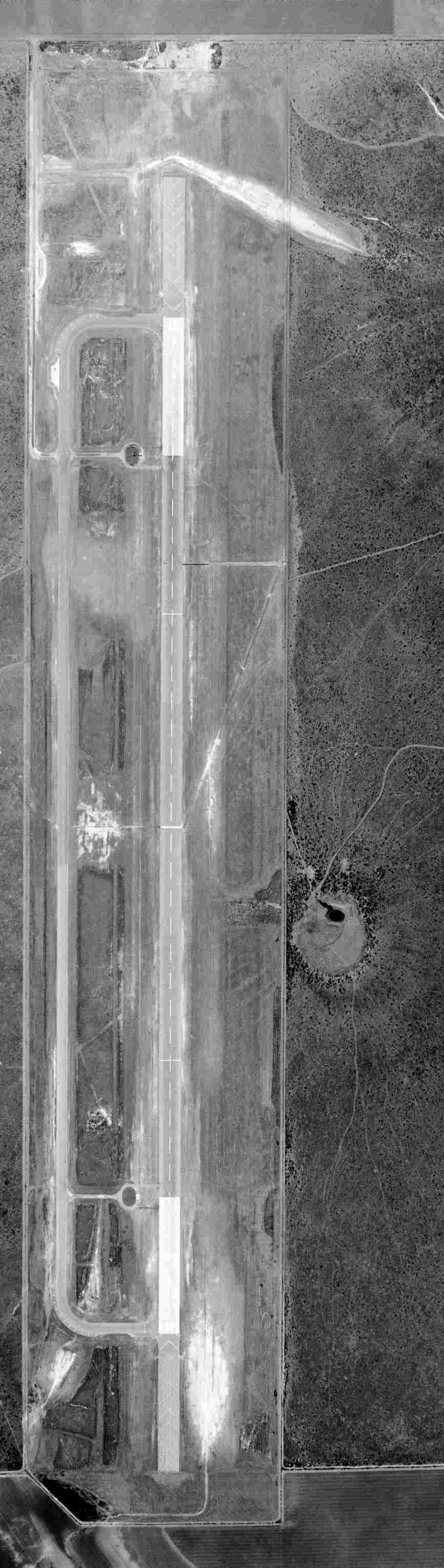
A 4/25/62 USGS aerial view of "Terry Co AF Aux".
A 1957 aerial view did not yet show Terry County Auxiliary Airfield.
According to an Army Corps of Engineers Environmental Impact Statement (courtesy of Rex Ricks),
“Terry County Auxiliary Airfield – Until developed, the TCAA site consisted of predominantly of agricultural crops & undeveloped grassland.
In 1960 the airfield was developed & consisted of a single north/south runway with a taxiway to the west.
A new fire station was constructed in 1960.”
A 2,826 square foot storage building was constructed in 1960.
The earliest photo which has been located of the Terry County AF Auxiliary Airfield was a 4/25/62 USGS aerial view,
which depicted it as having a single paved north/south runway.
The Army Corps of Engineers Environmental Impact Statement (courtesy of Rex Ricks) stated, “The runway was extended in the mid 1960s.”
The runway lengthening was intended to support jet training at nearby Reese AFB.

The earliest aeronautical chart depiction which has been located of Terry County Air Force Auxiliary Airfield was on the 1966 Roswell Sectional Chart (courtesy of John Voss).
It depicted "Terry Co AF Aux" as having a single 8,900' paved runway.
Dick Belle recalled, "I was a student at Reese in 1968-69.
We practiced visual approaches in the T-37 at Terry County. It was known as 'FIZZLE'.
I remember very clearly the radio call us neophyte pilots had to make as soon as we departed Reese on our way to Terry County:
'RUM-DUM, BLUE CHIP 42, WOOLFORTH FOR FIZZLE'.
Translation: Rum-dum was a flight following operation at Reese, Blue Chip the call sign,
Woolforth was a little West Texas town, and Fizzle was Terry County Aux.
It was quite a mouthful to blurt out while hanging on for dear life to our first jet.
Once you could say that & fly at the same time, you knew you were on the right track."
It was labeled "Terry County Auxiliary Airfield" on the 1973 & 1983 USGS topo maps.
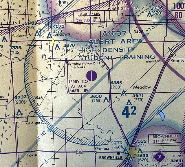
The last aeronautical chart depiction which has been located of Terry County Air Force Auxiliary Airfield was on the November 1985 Albuquerque Sectional Chart (courtesy of Jonathan Westerling).
It depicted "Terry Co AF Aux" as having a single 8,900' paved runway.
A 2,942 square foot fire station was built at the Terry County Auxiliary Airfield in 1990.
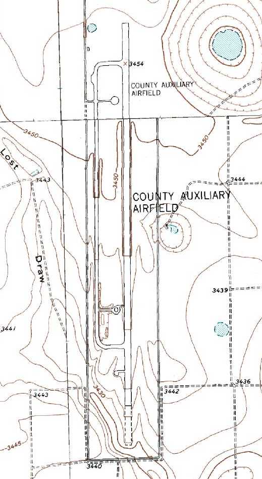
The Terry County Auxiliary Airfield was labeled merely "County Auxiliary Airfield" on the 1991 USGS topo map.
A 1996 USGS aerial view looking southwest at Reese Auxiliary Airfield, presumably while the field was still open.
A close examination reveals a light single-engine aircraft on (or low above) the center of the runway.
The Reese Auxiliary Airfield was presumably closed when Reese AFB itself closed in 1997, if not before.
At the time of its closure, the airfield consisted of 8,900' Runway 1/35 & a parallel taxiway.
At some point between 1996-2002, the former Reese Auxiliary Airfield was reused as a drag racing track, the Dolca Motorplex (thanks to Mike Bell for pointing this out).
Phil Cornell (the General Manager of the Ed Moseley AutoMall, a primary sponsor of the new drag strip) provided the following details about the airfield:
"When Reese closed a local crop duster in Levelland bought it [the auxiliary airfield]
so he wouldn't have to ferry loads all the way from Levelland to the Brownfield area to spray.
As you can tell, it was a lot more facility than any FLEET of crop dusters would need.
He was just landing on the taxiway, which is nicer than most small airports around here.
A friend of his saw it one day & mentioned that it would be a good drag strip.
I'm not sure of the exact specs but I believe the first half mile of it is concrete, 36 inches deep & 150 feet wide.
No civilian could afford to build that today. So, because of the construction it is a very fast drag strip that needs virtually no maintenance."
Ulrich Neumann recalled, “In 2002, the Sports-Class & 18m-Class National Contest was held at Reese AFB.
A total of around 80 gliders competed over a 2 week period.
One day, I didn't make it home due to a thunderstorm between me & Reese AFB.
I had no choice but to land at the Terry County Auxiliary Airfield.
The runway was in bad shape with weeds growing out of the seams,
but fortunately, a glider does not require a whole lot of space to land.
The field was used by the crop dusting operation.
They were flying a huge turbine-powered agricultural plane (Turbo-Thrush?) off the taxiway.”
The former Reese Auxiliary Airfield was being offered for sale on Ebay in 2005.
The 520 acre property (including the runway, taxiway, former fire station, and storage building) was listed for $1 million.
The runway was described in the sale listing as being 8,900' x 150’, plus 1,000’ overrun extension on both north & south ends.
Approximately 2,800' on the south end is paved concrete
and approximately 1,000' on the north end is paved concrete for the touchdown areas,
the center section is paved asphalt for the run-out distance, total surface area includes 181,667 square yards.
The taxiway was described as paved asphalt with some aircraft parking area & includes 71,217 square yards of surface area.
The former fire station (currently used as a shop / office building) is 2,942 square feet, and the storage building is 2,826 square feet.
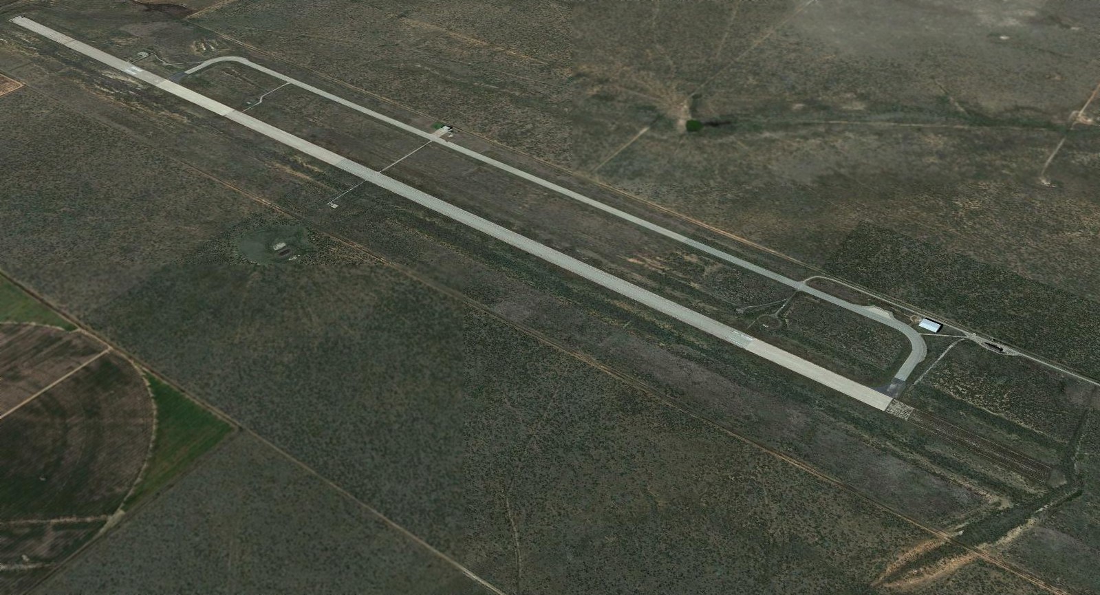
A 2017 aerial view looking southwest at the massive runway of the former Reese Aux Airfield.
____________________________________________________
32.85, -101.92 (South of Lubbock, TX)
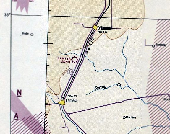
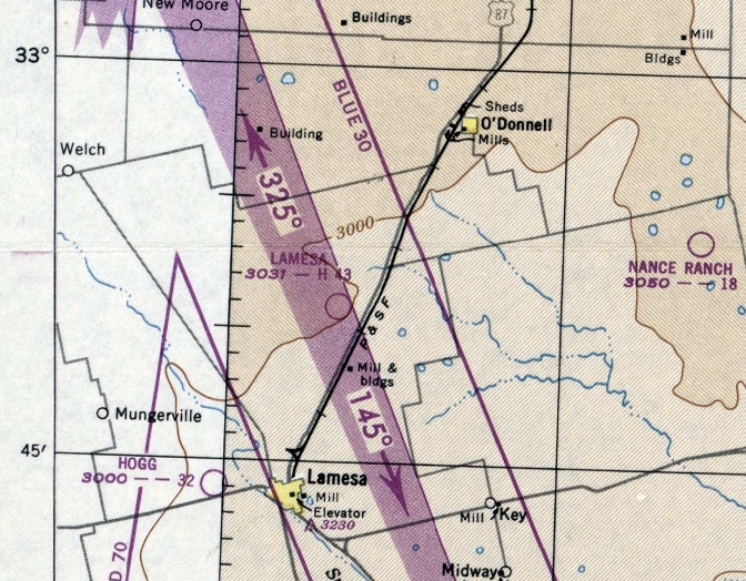
Lamesa Field, as depicted on the February 1943 Dallas Sectional Chart.
Lamesa Field was not yet depicted on the August 1941 Dallas Sectional Chart.
Lamesa Field was established in 1942 as an Army Air Forces contract flying school.
The John Wilson Glider School provided elementary & advanced glider training to Army aviation cadets
of the 28th Army Air Forces Glider Training Detachment until its deactivation in 1943.
In that year, the 3rd Army Air Forces Liaison Training Detachment was moved from Plainview to Lamesa,
with liaison pilot training provided by Clent Breedlove Aerial Services.
The earliest depiction which has been located of Lamesa Field was on the February 1943 Dallas Sectional Chart.
It depicted Lamesa Field as a commercial/municipal airport.
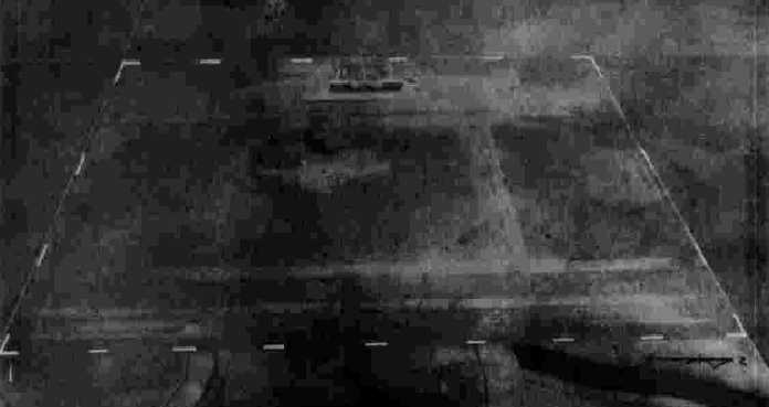
The earliest photo which has been located of Lamesa Field was a 10/14/43 aerial view looking west from the 1945 AAF Airfield Directory (courtesy of Scott Murdock).
It depicted Lamesa Field as a square grass area with several buildings along the west side.
Liaison pilot training ended at Lamesa in 1944.
The 1945 AAF Airfield Directory (courtesy of Scott Murdock) described Lamesa Field as a 640 acre square-shaped property having 3 runways,
the longest being the 4,280' asphalt penetration NNW/SSE strip.
The field was said to have 2 wooden hangars, the largest being a 200' x 100' building.
Lamesa was described as being owned by Dawson County, the City of Lamesa, and the Defense Plant Corporation.
The field was said to be operated by the Reconstruction Finance Corporation & the Defense Plant Corporation.
The remarks said “U.S. Government storage center for surplus aircraft.”
The last aeronautical chart depiction which has been located of Lamesa Field was on the February 1949 Dallas Sectional Chart.
It depicted Lamesa as having a 4,300' paved runway.
Lamesa Field was evidently abandoned at some point in 1949, as it was no longer depicted on the August 1949 Dallas Sectional Chart.
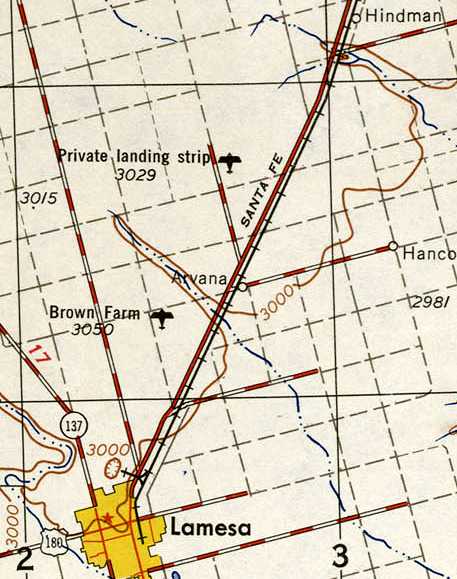
The 1954 USGS topo map depicted the former Lamesa Field simply as “Private Landing Strip”.
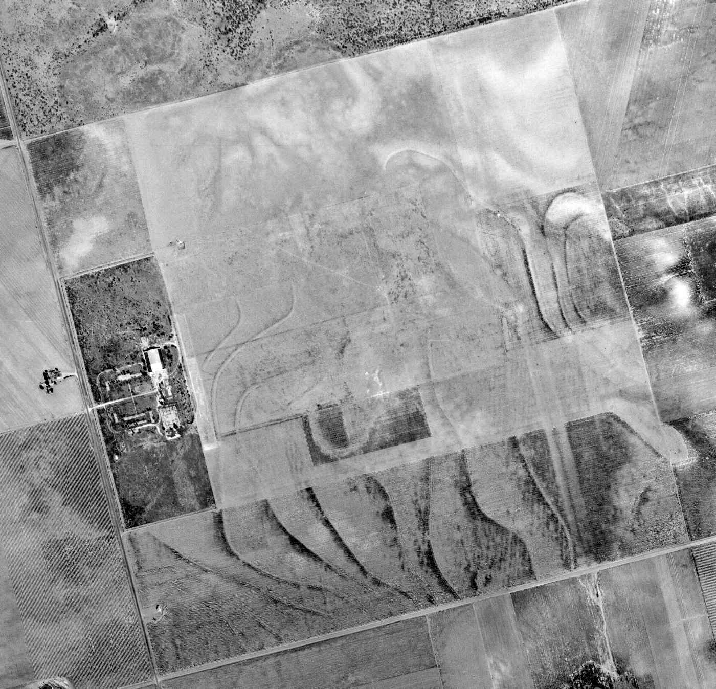
A 10/18/67 USGS aerial view of the site of Lamesa Field showed the majority of the airfield area had been returned to farming, but the remains of the ramp were still recognizable.
One hangar remained standing on the west side, but the southern hangar appeared to have been removed.
The former Lamesa Field wasn't depicted at all on the 1968 or 1974 USGS topo maps.
John Henson recalled, “In the 1970s the ramp still existed & a small portion of what appeared to be a runway was also there.
I flew over it many times while I was learning to fly & also saw it from the ground while driving around the area.”
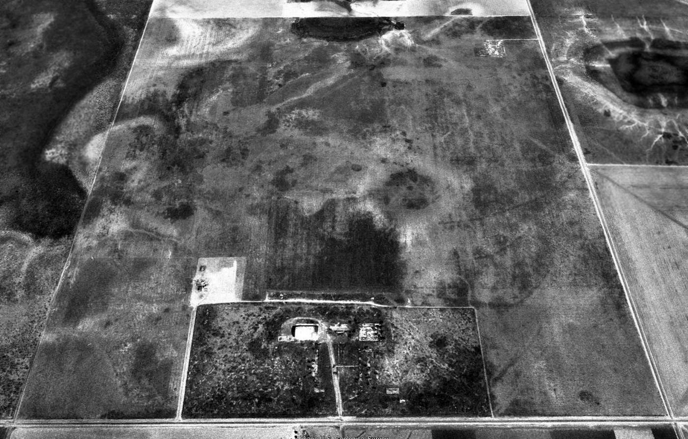
A 1991 USGS aerial view looking northeast at the site of Lamesa Field showed the rectangular outline that presumably delineated the airfield area is still intact, as well as one hangar on the west side.
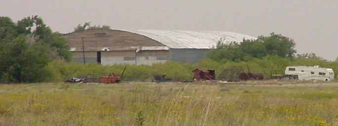
A 2002 photo by Scott Mudock looking northwest at the only remaining hangar at Lamesa.
John Henson reported in 2008, “Lamesa Field is for all practical purposes completely gone except for the hangar.
When I saw the remains the hangar was being used as a barn & the ramp had farm implements parked on it.
There was a farm house just to the southwest of the hangar.”
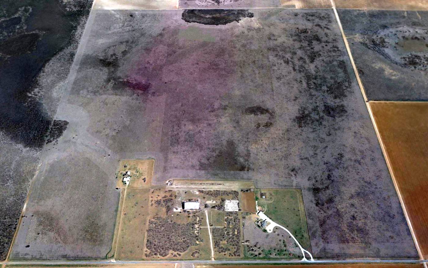
A 2016 aerial view looking northeast at the site of Lamesa Field showed the rectangular outline that presumably delineated the airfield area is still intact, as well as one hangar on the west side.
The site of Lamesa Field is located west of Glider Road (how appropriate!), two miles north of Route 87.
Thanks to Scott Murdock for locating this field.
See also: The Handbook of Texas Online.
____________________________________________________
Or if you prefer to contact me directly concerning a contribution (for a mailing address to send a check),
please contact me at: paulandterryfreeman@gmail.com
If you enjoy this web site, please support it with a financial contribution.
____________________________________________________
This site covers airfields in all 50 states.