Abandoned & Little-Known Airfields:
Western Tennessee
© 2002, © 2026 by Paul Freeman. Revised 7/2/26.
This site covers airfields in all 50 states: Click here for the site's main menu.
____________________________________________________
Please consider a financial contribution to support the continued growth & operation of this site.
Arlington Municipal Airport (revised 4/25/23 - Boen Field / Milan Municipal Airport (revised 11/3/21)
Gill-Dove Field (revised 4/13/21) - Isle-A-Port Airport (revised 4/25/23) - Memphis Flying Service Airport (revised 12/7/25) - NOLF 09507 / Site 6 / Base 9 (revised 11/2/21)
NOLF 15305 (revised 1/21/17) - Jacks Creek Intermediate Field (revised 4/13/21) - Memphis Downtown Airport / Mud Island Airport (revised 2/10/24)
NOLF 34105 / Hagler Airport (revised 11/24/17) - Savannah Airfield (added 12/24/19) - Wilson Field (revised 7/2/26)
____________________________________________________
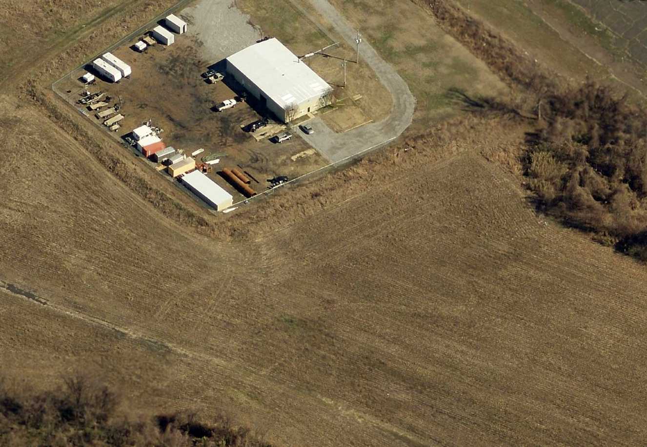
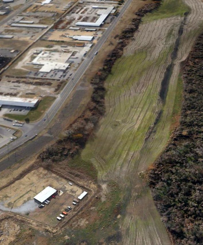
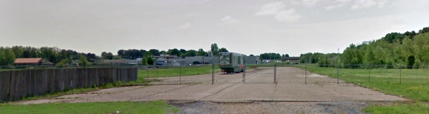
Savannah Airfield, Savannah, TN
35.18, -88.02 (Southwest of Nashville, TN)
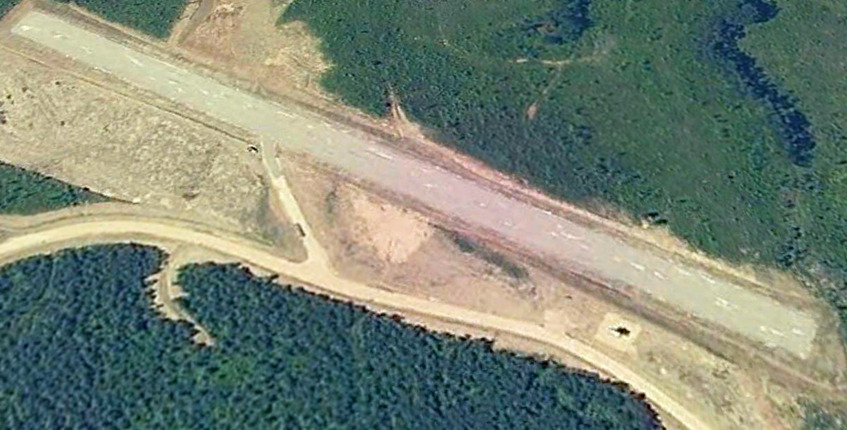
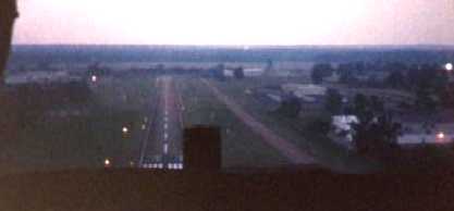
The Savannah runway apparently under construction, as seen in a 2010 aerial view looking north.
The specific name of this airfield has not been determined.
A 2008 aerial photo did not yet show any airfield at this site.
A 2010 aerial view showed construction under way of a single paved northwest/southeast runway.
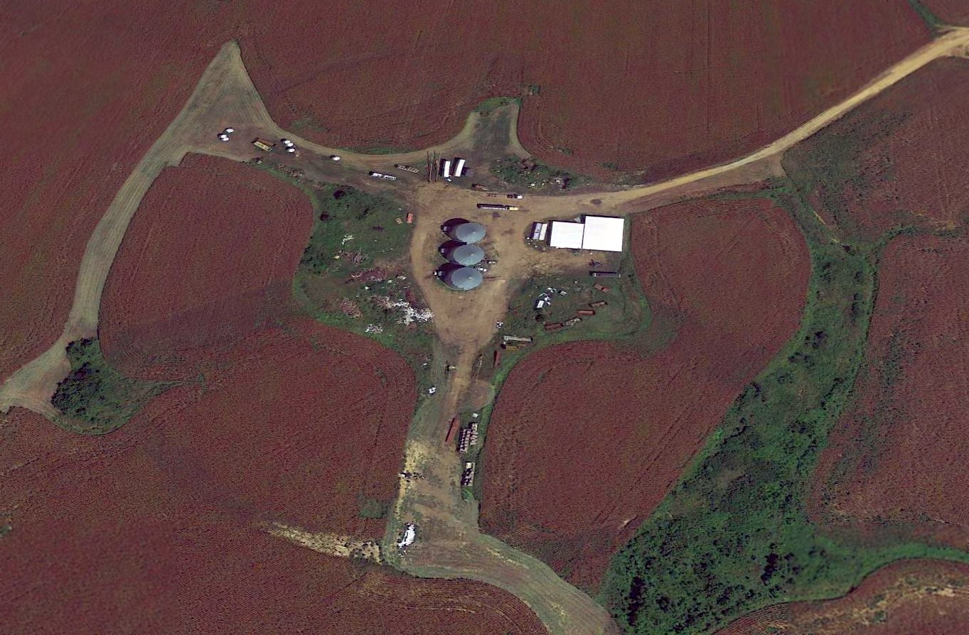
This unusual installation in a remote part of TN was built for testing unmanned aerial vehicles.
The airfield was evidently never listed with the FAA or charted as a manned aircraft airfield,
even though it had a paved 2,300' runway, 2 hangars, and a control tower with its own radar.
The airfield was not depicted on the 2013 USGS topo map.
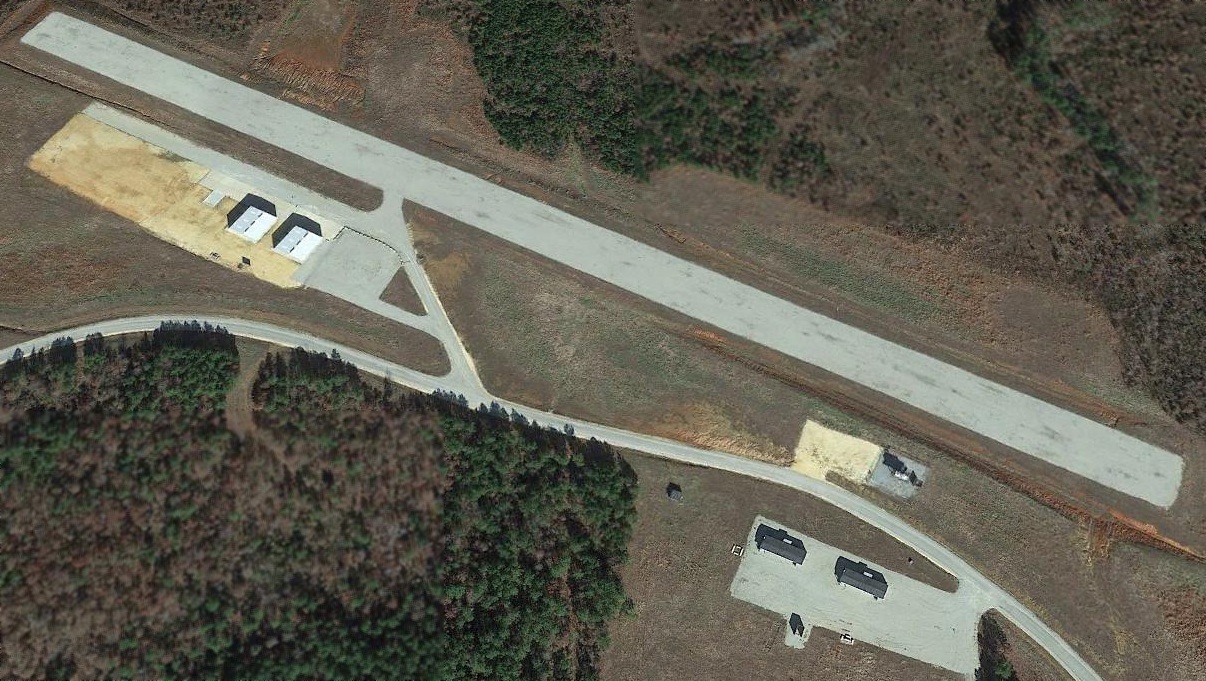
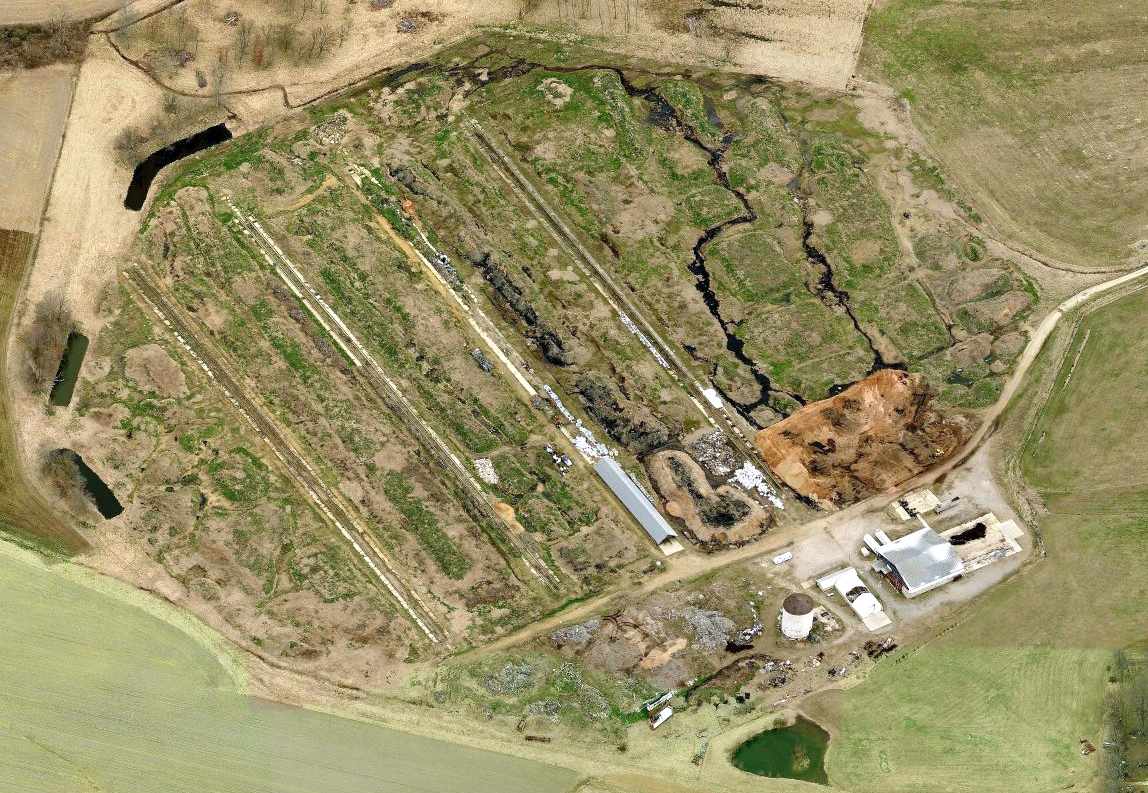
A 2015 aerial view looking north at the Savannah Airfield showed it to have a single paved northwest/southeast runway,
a paved ramp with 2 hangars on the southwest side, and a control tower on the southeast side.
The airfield was not depicted on the 2016 USGS topo map.
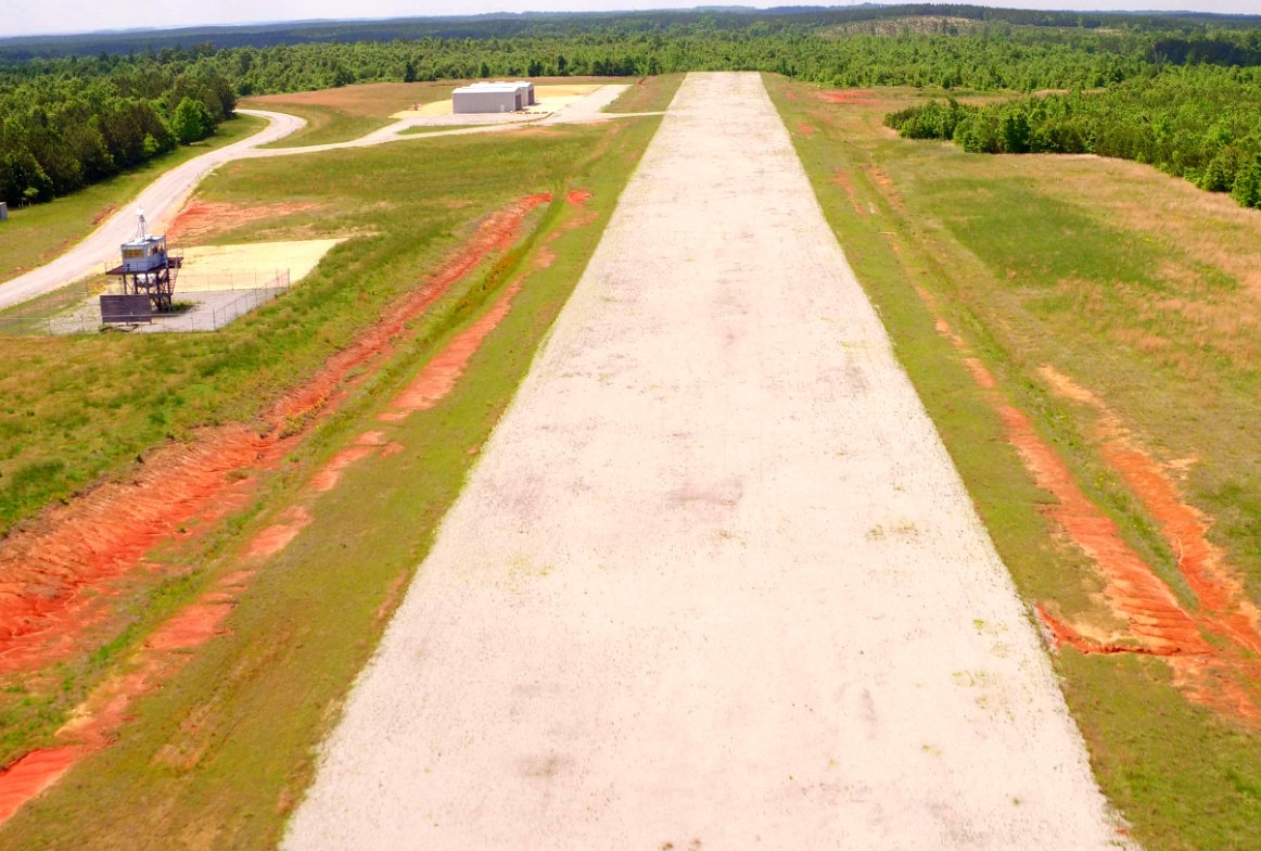
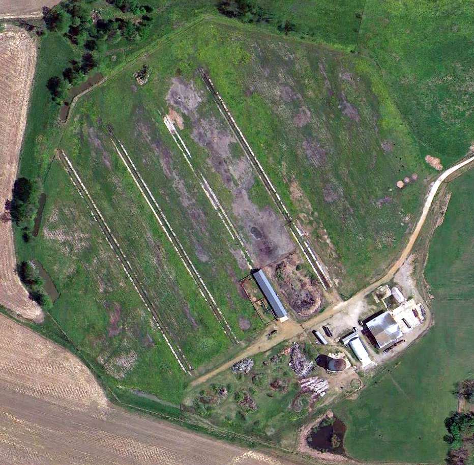
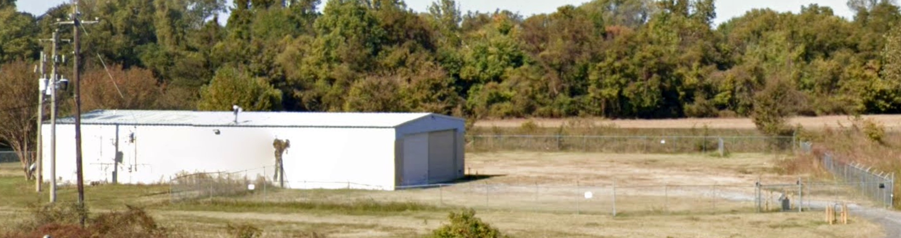
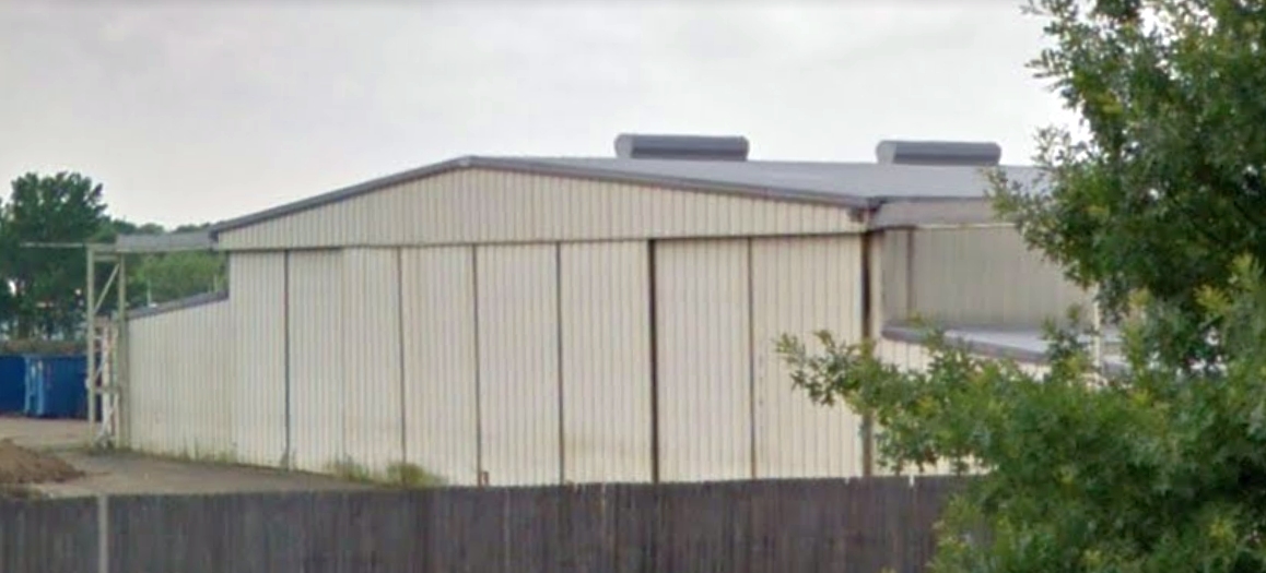
A 2019 aerial view looking northwest along the Savannah runway, showing the 2 hangars on the southwest side & the control tower on the southeast side.
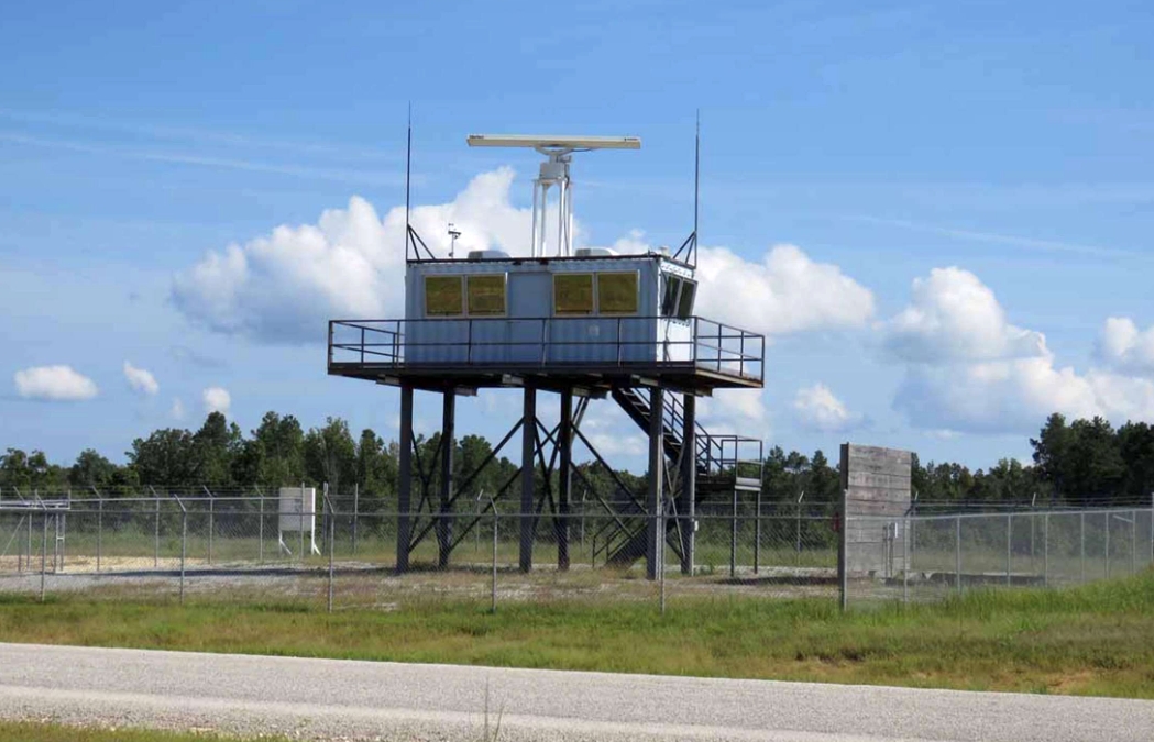
A 2019 photo of the Savannah control tower, complete with a radar on top.
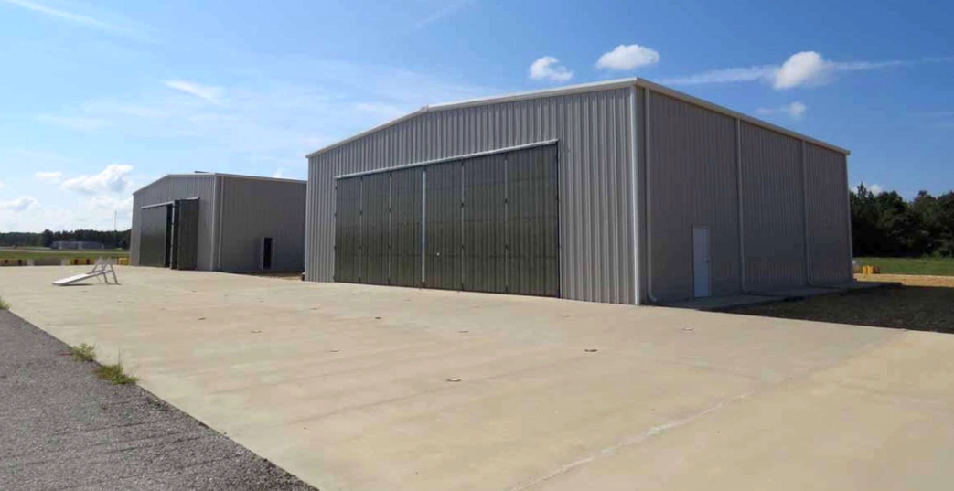
A 2019 photo of the 2 Savannah hangars.
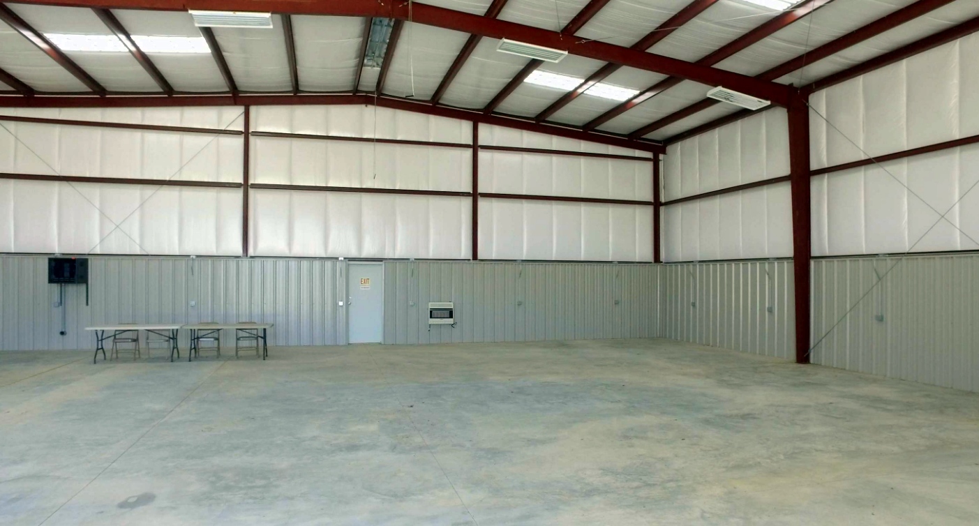
A 2019 photo of the interior of a Savannah hangar.
A 2019 real estate listing advertised a listing price of $8,650,000 for the 6,203 acres including the airfield & its accompanying facilities.
____________________________________________________
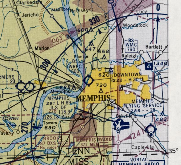
Memphis Flying Service Airport, Memphis, TN
35.058, -89.898 (Southeast of Downtown Memphis, TN)
Memphis Flying Service Airport was depicted simply as “Memphis” on the April 1945 Chattanooga Sectional Chart.
This small general aviation airport on the southeast side of Memphis was evidently established at some point between 1942-45,
as it was not yet depicted on the August 1942 Chattanooga Sectional Chart.
The earliest depiction which has been located of Memphis Flying Service Airport was on the April 1945 Chattanooga Sectional Chart.
It labeled the field simply as “Memphis”, which must have led to confusion as it also labeled the main Memphis Airport (a few miles west) with the same exact name.
According to Memphis Magazine, “Memphis Flying Service was a grass landing strip, a couple of hangars, and some basic maintenance facilities.
It had no tower, and probably not any navigation lights. A wind sock told flyers which way the wind was blowing, and that was it.
But what made this particular base unusual was the person who ran it.”
According to an old Memphis Press-Scimitar article, "For the first time in the history of Memphis aviation,
a woman has been named general manager of one of the city's largest privately-owned aviation enterprises."
According to Memphis Magazine, “In fact, at the time - we're talking late 1940s here - LaVelle Walsh was the only female airport operator in the United States.
Not for long. Walsh stepped down the following year, for reasons not made clear in the newspaper articles.”
Even so, “She injected new life into the local flying game, and made Mid-South operators sit up & take notice."
According to Memphis Magazine, “Among other accomplishments, she made Memphis Flying Service the largest veterans flight-training school in this region.”
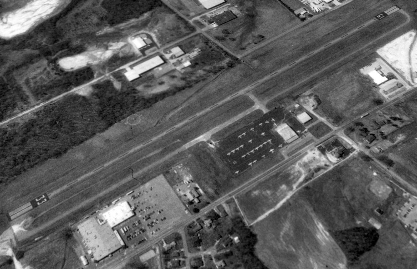
The earliest photo which has been located of Memphis Flying Service Airport was a 1956 aerial view.
It depicted Memphis Flying Service Airport as having 2 unpaved runways, with 4 hangars & 11 light single-engine aircraft on the southwest side.
Memphis Flying Service Airport, as depicted on the 1959 USGS topo map.
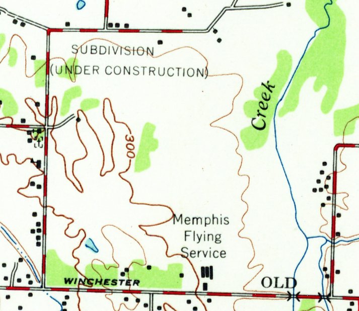
The 1960 USGS topo map depicted Memphis Flying Service Airport as having 4 buildings on the south side of an open field.
Note that ominously it also depicted “SUBDIVISION (UNDER CONSTRUCTION)” on the north side of the airport property -
a factor which would soon consume the little airport.
The last aeronautical chart depiction which has been located of the Memphis Flying Service Airport was on the February 1960 Chattanooga Sectional Chart.
It depicted the field as having a 2,800' unpaved runway.
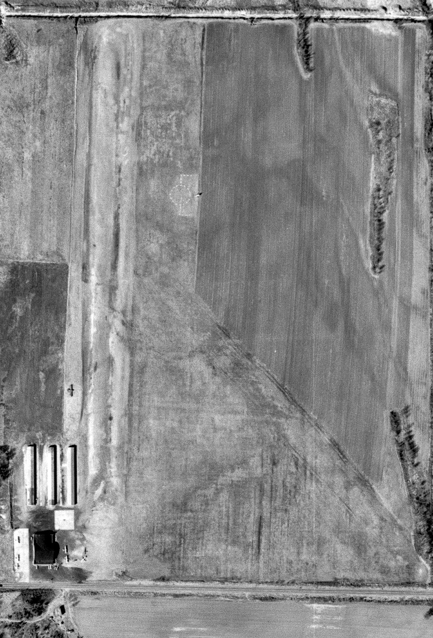
The last depiction which has been located of Memphis Flying Service Airport (and the only photo of it which is available) was a 3/6/63 USGS aerial view.
The airfield configuration remained unchanged, compared to the 1956 photo, but the number of aircraft visible on the field had decreased to 7.
According to Memphis Magazine, “The little airfield closed sometime in the late 1960s.”
Memphis Flying Service Airport was evidently closed at some point between 1963-65,
as it was no longer depicted on the August 1965 Chattanooga Sectional Chart.
The 1965 USGS topo map continued to depict the 4 hangars of Memphis Flying Service,
and the majority of the airfield area remained clear, but residential streets had covered the northern portion.
Ronnie Kelly recalled, “I grew up in the 1960s in the Parkway Village area of Memphis.
As a kid, we often played at an abandoned Fixed-Base Operator that was just blocks from our house (I lived on Luzon Drive).
This FBO would have been at what is now the intersection of Winchester Road & Clearbrook.”
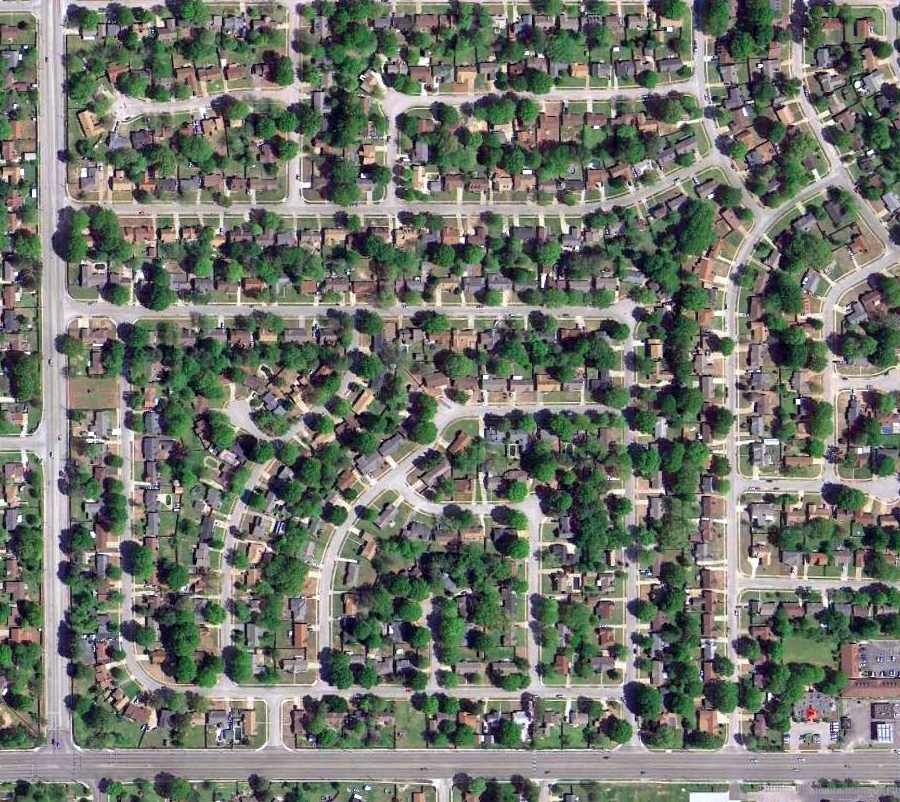
A 1971 aerial view showed no trace remaining of Memphis Flying Service Airport, with the site covered by houses.
Yet another of our nation's thousands of grassroots airports consumed by the never-ending appetite for housing.
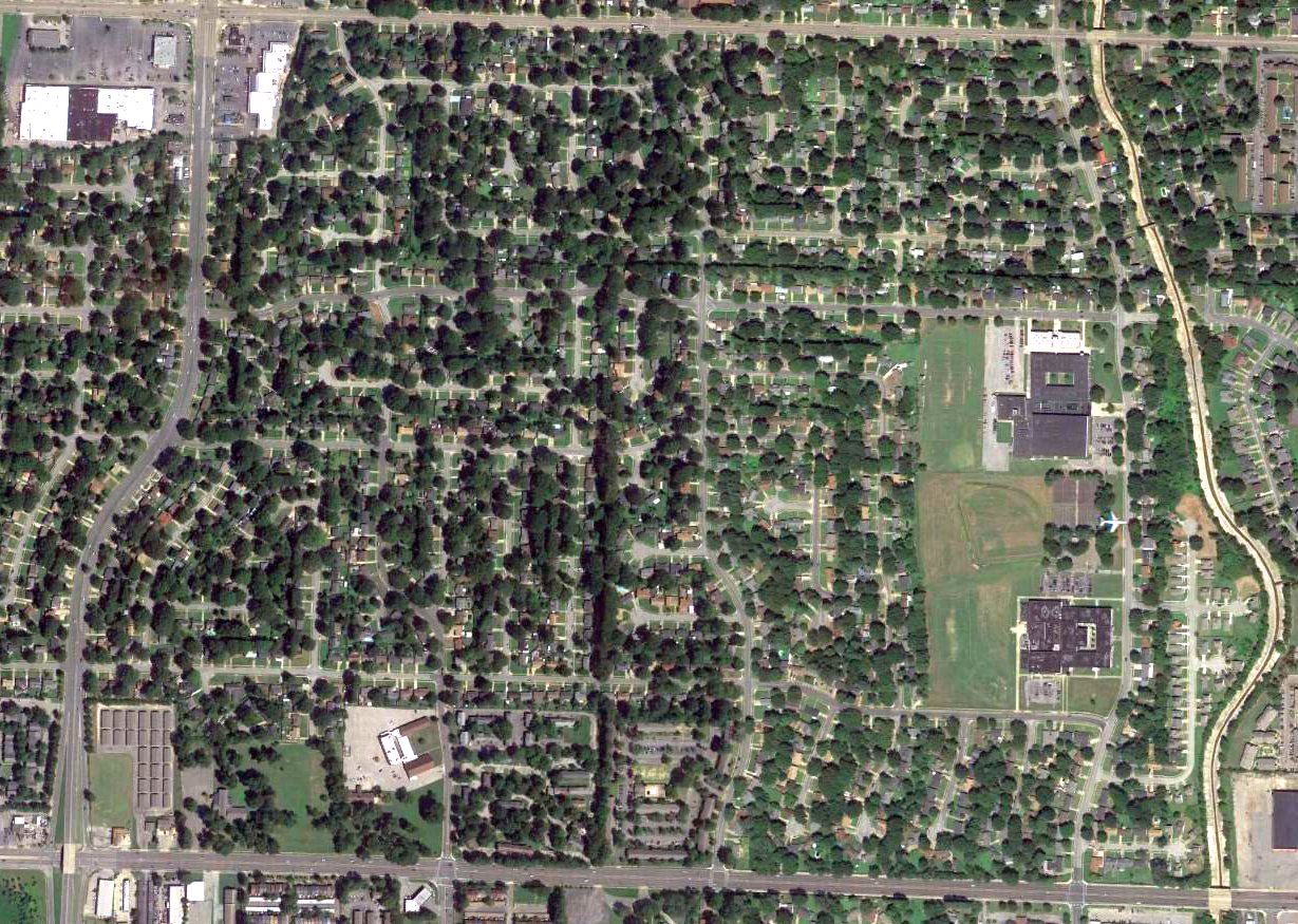
A 2017 aerial view showed no trace remaining of Memphis Flying Service Airport.
Ironically though, the photo did capture a 737 overflying the east side of the airport site.
Thanks to Ronnie Kelly for pointing out this airfield.
____________________________________________________
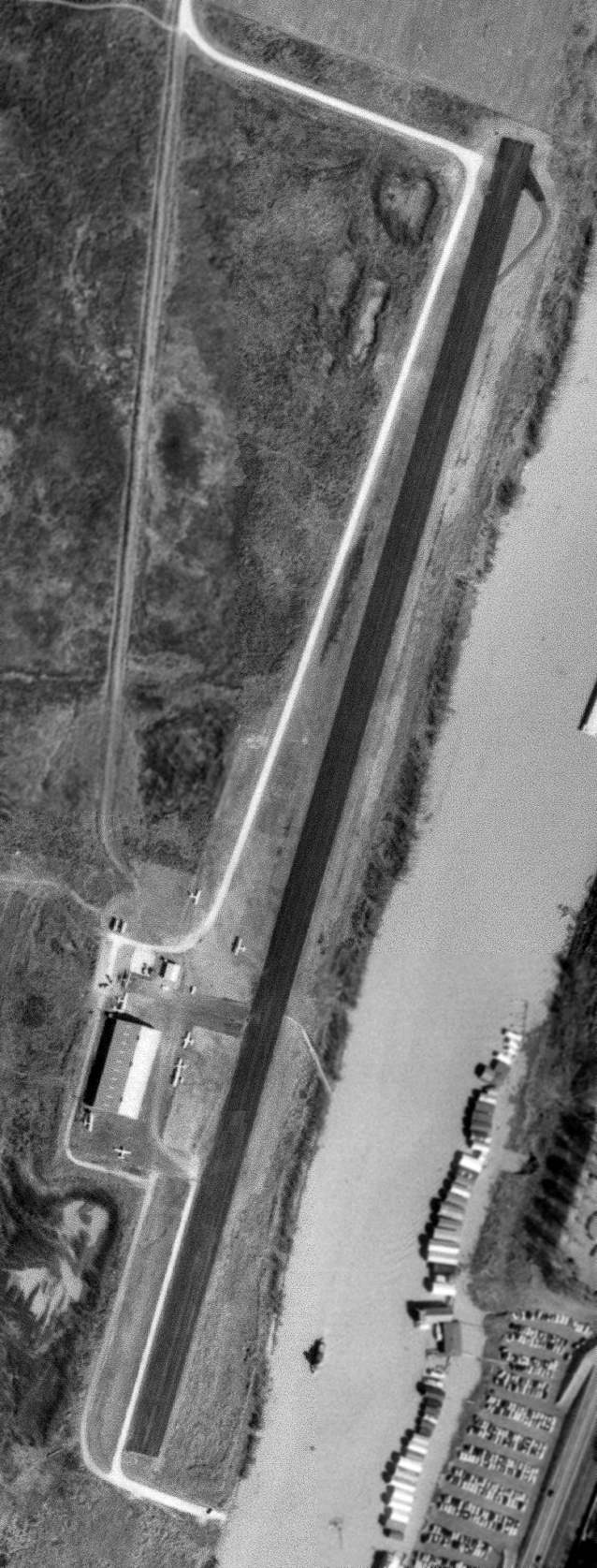
35.04, -89.85 (Southeast of Downtown Memphis, TN)
Wilson Field, as depicted on a 10/22/43 aerial view looking north from the 1945 AAF Airfield Directory (courtesy of Scott Murdock).
According to an article by Vance Lauderdale in the 5/29/12 Memphis Magazine, “Wilson Field was owned & operated by Harry Wilson.
A self-taught pilot since 1915, Wilson had flown in the Signal Corps during World War I
and teamed up with Vernon Omlie, one of this area's first aviators, in the 1920s.
He took over Omlie's Mid-South Airways Corporation after the older pilot died in a plane crash near St. Louis in 1938.
Wilson moved the company to Memphis Municipal Airport,
but had to relocate several miles east when the U.S. Army commandeered the city's main airfield during World War II.
During the war, he supervised pilot training for the military.
In later years, he provided flight classes, aircraft maintenance, and other services,
and slowly built up a sprawling 'boneyard' of vintage airplanes & parts.”
Wilson Field was not yet depicted on the August 1942 Memphis Sectional Chart.
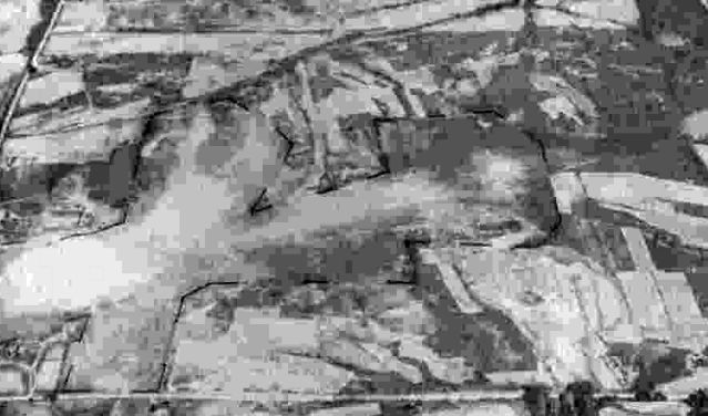
The earliest depiction which has been located of Wilson Field was a 10/22/43 aerial view looking north from the 1945 AAF Airfield Directory (courtesy of Scott Murdock).
It depicted Wilson Field as an irregularly-shaped unpaved airfield.
The earliest aeronautical chart depiction which has been located of Wilson Field was on the March 1944 Memphis Sectional Chart.
It depicted Wilson Field as a commercial/municipal airport.
The 1945 AAF Airfield Directory (courtesy of Scott Murdock) described Wilson Field as a 160 acre property having 3 sod runways, the longest measuring 2,600' east-northeast/west-southwest.
It was said to have a single wood hangar, and to be owned & operated by private interests.
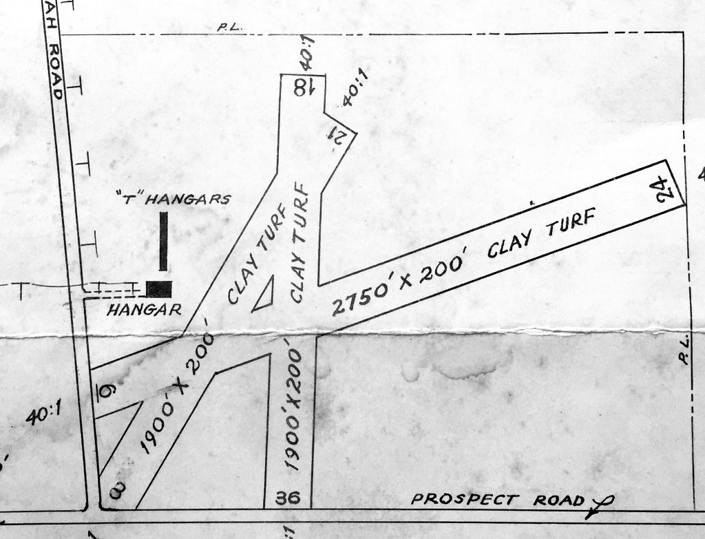
A diagram of Wilson Field from a 10/27/47 FAA record (courtesy of Emmett “Red” Atkins, via Don Jones)
depicted Wilson Field as having 3 clay turf runways, with the longest being the 2,750' Runway 6/24.
A hangar & T-hangars were located on the northwest side.
Frank Bawlow recalled, “My father flew out of Wilson Field as a young man in his Aeonca Chief.
My father also went flying with one of Harry's cats unexpectedly one day; thankfully the wild cat stayed in the wing.”
The earliest photo which has been located of Wilson Field was a 1954 USGS aerial view (courtesy of Richard Stieg).
It depicted Wilson Field as having 2 unpaved runways, with a building & several light aircraft on the northwest side.
Richard Stieg recalled of Wilson Field, “There were several WW2-era aircraft located on the field along with a number of civilian aircraft,
one of which was a 1946 Aeronca Champ owned by my Uncle, Warren Slater.
This was where I took my first flight at age 9.
I remember 3 T-6s & a Beech 18 sitting in the tall weeds slowly fading away.
There were a number of hangars still smelling of dope & mahogany & pine shavings, and it seemed like a dozen cats dozing everywhere.
I remember flying out of there several times as a kid.”
Wilson Field, as depicted on the 1959 USGS topo map.
According to an article by Vance Lauderdale in the 5/29/12 Memphis Magazine, “In the 1960s, a reporter visited Wilson Field 'in the quiet countryside'
and noted that 'airplanes remain on the field from World War II training days.
Weeds & young trees grow through their fuselages.
Wilson says one man wants one of the old planes as a plaything for his children.'”
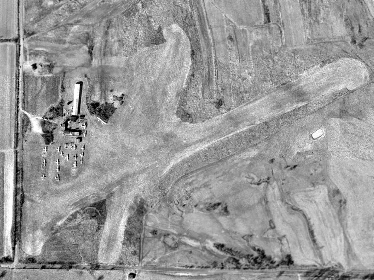
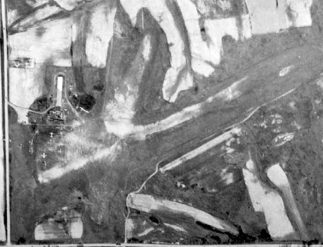
A 3/6/63 USGS aerial view depicted Wilson Field perhaps at the zenith of its popularity,
with a total of 19 light aircraft parked amidst the buildings on the northwest side of the 2 grass runways.
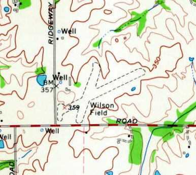
The 1965 USGS topo map depicted Wilson Field as having 2 unpaved runways & 2 small buildings on the northwest side.
Lauderdale continued, “It was certainly an odd place.
Many years ago, I confess to a bit of trespassing, when I went with some friends to explore it at night.
At the time, there was even a big old DC-3 parked there, and we climbed through a door, roamed through the cluttered cabin, and sat in the cockpit.
Suddenly, a light flashed on in the hangar across the field - we didn't know anyone stayed there at night! -
so we got spooked & scurried away, half-expecting to get shot before we reached our cars.”
The December 1968 Memphis Sectional Chart (courtesy of Ron Plante) depicted Wilson Field as having a 2,700' unpaved runway.
The 1973 USGS topo map continued to depict Wilson Field in an unchanged manner.
Rick Herberger recalled, “I met Mr. Wilson in 1971, and visited this airport occasionally.
I happened upon Wilson Field, flying in & out of there several times.”
The last aeronautical chart depiction which has been located of Wilson Field was on the May 1972 Memphis Sectional Chart.
It depicted Wilson as having a 2,400' unpaved runway.
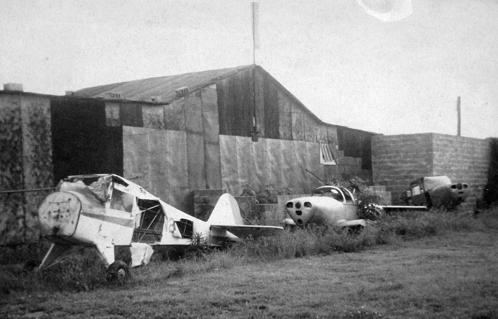
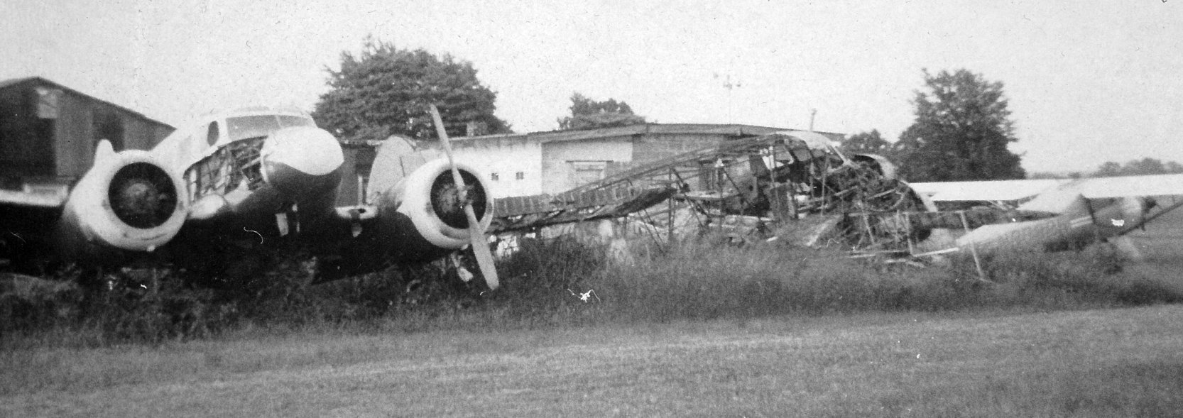
The last photos which has been located of Wilson Field were a set of July 1973 photos by Rick Herberger of a group of forlorn aircraft at Wilson Field,
including this Piper Cub, Ercoupe, and another unidentified single-engine taildragger behind a hangar.
Rick Herberger recalled, “I asked Mr. Wilson for permission to take the pictures, and he allowed me to poke around the planes & into the storage buildings & hangars.
A true treasure trove of old aircraft, engines, and parts.”
A July 1973 photo by Rick Herberger of 2 Cessna T-50 Bobcats at Wilson Field.
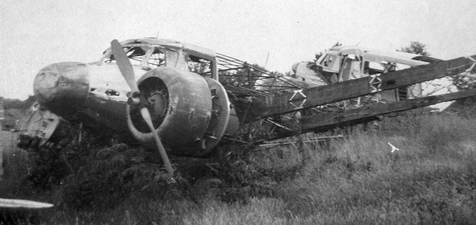
A July 1973 photo by Rick Herberger of 2 Cessna T-50 Bobcats at Wilson Field.
Rick Herberger recalled, “I think Mr. Wilson passed away in 1975,
a developer bought the land from his heirs & I was told that the developer plowed everything under instead of hauling it off to a dump site.
But who knows what really happened.”
Lauderdale continued, “Wilson, hailed by the Memphis Press-Scimitar as 'a pioneer figure in aviation in Memphis', died in 1975.”
Richard Stieg recalled, “After Harry passed away, I heard that the Smithsonian hauled away
several flatbed loads of aircraft parts including an almost complete Stearman carcass.
The property was sold & totally developed in a residential subdivision by 1980.”
The 1983 USGS topo map depicted dense residential streets covering the site of Wilson Field.
Wilson Field was no longer depicted on the May 1987 Memphis Sectional Chart.
A 2014 aerial view showed no trace remaining of Wilson Field.
The site of Wilson Field is located northwest of the intersection of Ridgeway Road & East Raines Road.
Thanks to Richard Stieg for pointing out this airfield.
____________________________________________________
Naval Outlying Landing Field 09507 / Site 6 / Base 9, Bolton, TN
35.29, -89.83 (Northeast of Memphis, TN)
Memphis NOLF 09507, as depicted on the March 1944 Chattanooga Sectional Chart.
Memphis Naval Outlying Field #09507 (also known as Site 6 or Base 9) was one of at least 16 outlying fields
used to support high-volume flight training operations based at NAS Memphis [6 miles west] during the Second World War.
The designation of Naval Outlying Land Field 09507
refers to its bearing from the parent Naval Air Station, NAS Memphis (095 degrees) and its distance (07 nautical miles).
According to Brian Rehwinkel, “NAS Memphis had a very unusual reference system for its fields relative to the other training stations.
NAS Memphis had Base numbers, Site numbers, and Bureau of Aeronautics numbers for each of its fields.
This field was Base number 9, Site number 6, and BuAer number 09507.”
Memphis OLF #09507 was not yet depicted on the August 1942 Chattanooga Sectional Chart.
According to Brian Rehwinkel, “Memphis OLF #09507 was one of the early fields acquired for training at NAS Memphis.
The field was apparently acquired sometime in late fall or early winter in 1942
(the first OLF was opened on 10/23/42, according to the station history).
Soon after the field was opened, the decision was made to make this an all-weather field & place a paved mat on the field
(the field was relatively small at just under 127 acres).
The land for this field was originally leased & the Navy apparently later purchased most of the land for this field (and all other paved OLFs supporting NAS Memphis).
The mat was an octagon-shaped landing mat consisting of asphalt – 2 inches in depth over a 6 inch rock base - with a maximum length of 1,500’ for takeoffs & landings.
This was a pretty typical length for these types of training fields.”
The octagon airfield configuration was somewhat common to WW2-era NOLFs,
which permitted flight training operations to be conducted regardless of the direction of the prevailing wind.
A 4/1/44 “Outlying Field Report” for NAS Memphis (from the National Archives, courtesy of Brian Rehwinkel)
indicated that NOLF 09507 was apparently still being leased.
The earliest depiction which has been located of NOLF 09507 was on the March 1944 Chattanooga Sectional Chart.
It depicted NOLF 09507 as an auxiliary airfield.
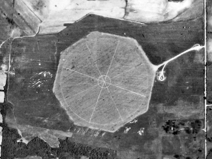
The earliest photo which has been located of NOLF 09507 was an 8/14/45 National Archives aerial view (courtesy of Brian Rehwinkel).
It depicted NOLF 09507 as an asphalt octagon, without any buildings.
The last aeronautical chart depiction which has been located of NOLF 09507
was on the top-right of this portion of the October 1946 Chattanooga Sectional Chart (courtesy of Chris Kennedy).
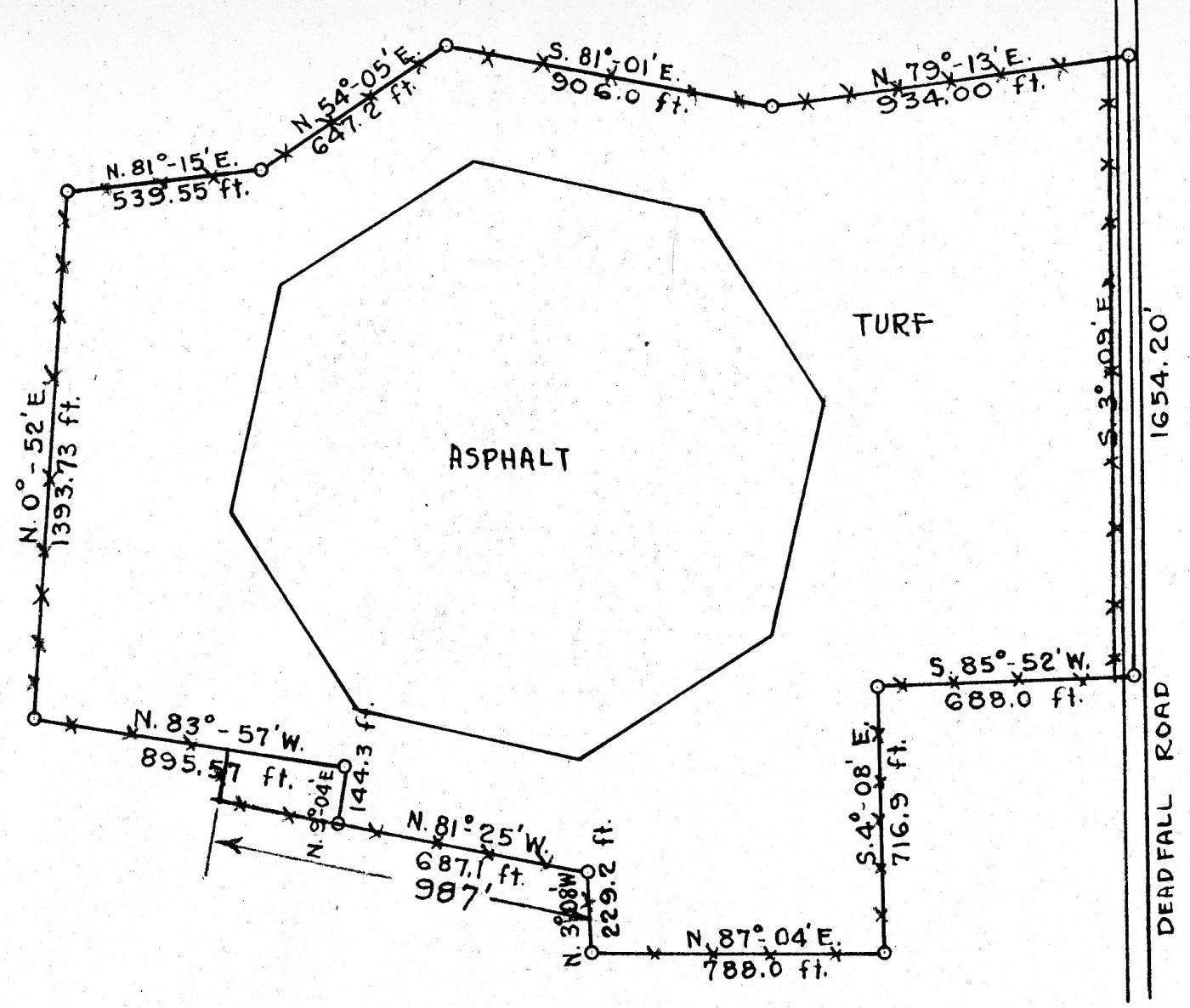
A circa 1946-47 National Archives layout map of “Auxiliary Training Field Site 6 #09507” (courtesy of Brian Rehwinkel) depicted its octagon-shaped airfield layout.
According to Brian Rehwinkel, “The field was used for a short time by the Navy after WWII, but, like so many other fields, just wasn’t suitable for post-war use.
Although I don’t know exactly when this field was disposed of, I believe it was probably sometime in the mid-1950s.
Several other of the paved fields used by Memphis were disposed of at this time.”
Jerry McLin recalled, “As a kid my Dad & I use to fly model airplanes at [Base] 9 which was south of Godwin Road & west of Deadfall Road in the area of Rosemark,
a Naval Outlying Field of Naval Air Station Memphis.”
A 4/2/63 USGS aerial view showed a large set of farming buildings had been constructed over the airfield octagon of NOLF 09507 at some point between 1945-63.
A circa 2010 aerial view looking north showed most of the farming buildings had been removed from the NOLF 09507 site at some point between 1963-2010.
The airfield pavement had also been removed, but the octagonal outline was still plainly recognizable.
A 2014 aerial view showed the NOLF 09507 octagonal airfield outline was still plainly recognizable.
The site of NOLF 09507 is located southwest of the intersection of Godwin Road & Deadfall Road.
Thanks to Jerry McLin for pointing out this airfield.
____________________________________________________
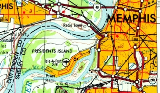
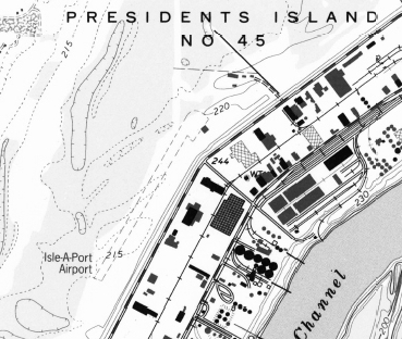
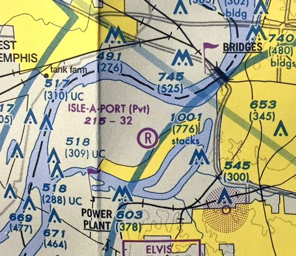
Isle-A-Port Airport (TN43), Memphis, TN
35.1, -90.11 (West of Downtown Memphis, TN)
The beginnings of Isle-A-Port Airport, as depicted on a 3/8/73 USGS aerial photo (courtesy of Dallam Oliver-Lee).
This small general aviation airport on President's Island (actually a peninsula in the Mississippi River)
was evidently created at some point between 1968-73,
as it was not yet depicted on a 1968 aerial photo (courtesy of Dallam Oliver-Lee).
The earliest photo which has been located of Isle-A-Port Airport
was a 3/8/73 USGS aerial photo (courtesy of Dallam Oliver-Lee).
It depicted perhaps the start of the airport, with just a single unpaved northeast/southwest runway.
Isle-A-Port Airport was not yet depicted on the November 1974 Memphis Sectional Chart (courtesy of Ron Plante).
The first labeled depiction which has been located of Isle-A-Port Airport was on the 1978 USGS topo map (courtesy of Dallam Oliver-Lee).
The earliest aeronautical chart depiction which has been located of Isle-A-Port Airport
was on the 1985-86 TN Aeronautical Chart (courtesy of Alex Hauzer).
It depicted Isle-A-Port as a “STOL” (Short Takeoff & Landing) field having a 2,200' unpaved runway.
The last topo map depiction which has been located of Isle-A-Port Airport was on the 1993 USGS topo map (courtesy of Dallam Oliver-Lee).
It depicted Isle-A-Port as having a single unpaved northeast/southwest runway, with one small building on the northeast side.
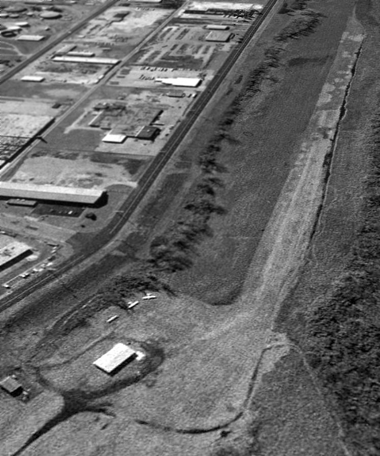
The only photo which has been located showing aircraft at Isle-A-Port Airport was a 1994 USGS aerial view looking southwest.
It showed 3 single-engine aircraft parked near the small building at the northeast end of the runway.
The last aeronautical chart depiction which has been located of Isle-A-Port Airport
was on the 2009 Memphis Terminal Aeronautical Chart.
It depicted Isle-A-Port as a private airfield having a 3,200' unpaved runway.
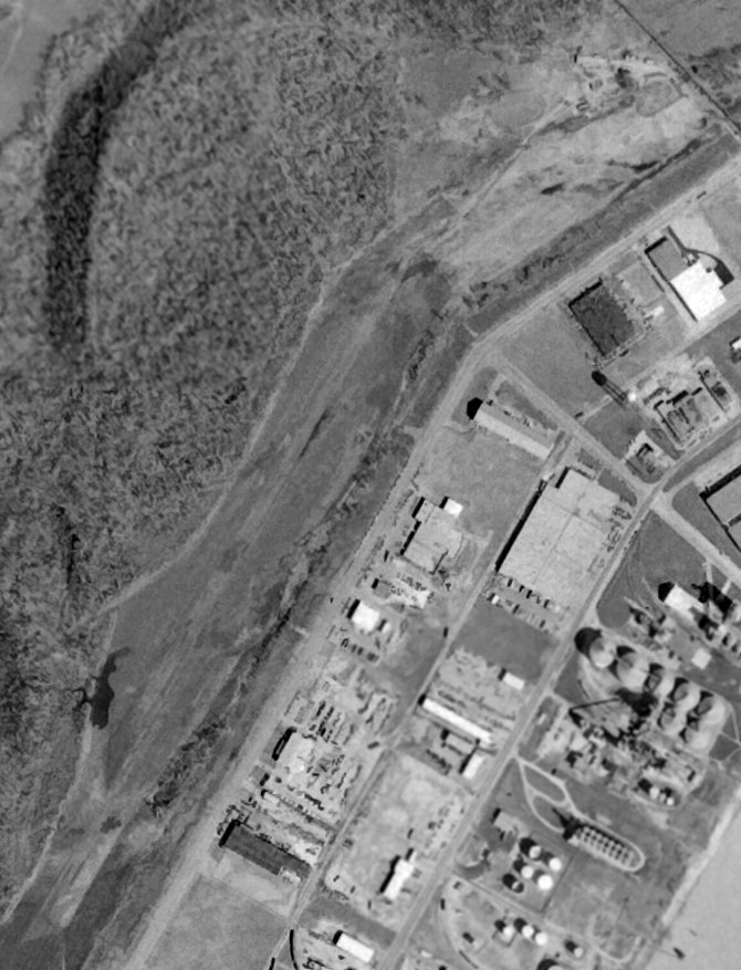
A circa 2010 aerial view looking east showed the airport building remained intact, though fenced off from the runway, which was very deteriorated.
A 11/1/12 aerial view looking southwest showed the airport building remained intact, though fenced off from the runway, which was very deteriorated.
Isle-A-Port Airport was evidently closed (for reasons unknown) at some point between 2009-2017,
as it was no longer depicted on the 2017 Memphis Sectional Chart.
A 2021 photo looking west at the former Isle-A-Port hangar.
The site of Isle-A-Port Airport is located west of the intersection of Harbor Avenue & Dock Street.
Thanks to Dallam Oliver-Lee for pointing out this airfield.
____________________________________________________
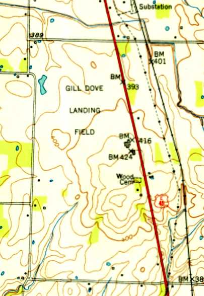
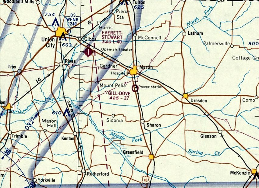
36.3, -88.85 (West of Nashville, TN)
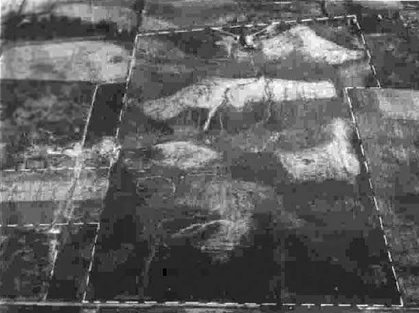
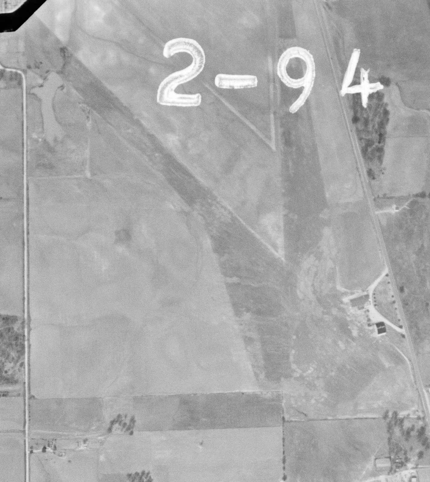
Gill-Dove Field, as depicted on the September 1941 Nashville Sectional Chart.
Gill-Dove Field was not yet depicted on the June 1939 Nashville Sectional Chart.
According to the book “The Aviation History of Tennessee” by Jim Fulbright (courtesy of David Stevenson),
“Gill-Dove Field was opened in 1940 along Highway 45E, south of Martin.
Its name was derived from flying service operator Gilbert Stalcup & his wife Dove, who called their business Dove Airways.
Stalcup owned the property & he initially leased the airfield to the City of Martin & later to Weakley County.
The field consisted of a 3,600' north/south turf runway & a 3,400' northwest/southeast turf strip.”
According to the book “The Aviation History of Tennessee” by Jim Fulbright (courtesy of David Stevenson),
“In 1940 Dove Airways conducted the Civilian Pilot Training Program which provided primary instruction necessary for a pilot's licence.
Occasionally Army personnel were ordered to the CPTP.”
Both Army & Navy cadets were instructed at Gill-Dove during the war.
The earliest depiction which has been located of Gill-Dove Airport was on the September 1941 Nashville Sectional Chart.
It depicted Gill-Dove as a commercial/municipal airport.
The earliest photo which has been located of Gill-Dove Airport
was an 11/3/43 aerial view looking east from the 1945 AAF Airfield Directory (courtesy of Don Coady).
It depicted the field as an unpaved landing area with a building along the east side.
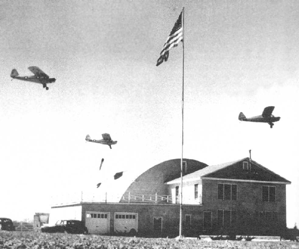
A circa 1940-45 photo of 3 Piper J-3 Cubs of the Civilian Pilot Training program overflying the Gill-Dove hangar.
The 1945 AAF Airfield Directory (courtesy of Scott Murdock) described Gill-Dove Airport
as a 207 acre rectangular property having 4 sod runways, the longest being a 3,900' northeast/southwest strip.
The field was said to have 3 hangars (the largest being a 107' x 60' wood structure),
and to be owned & operated by private interests.
According to the book “The Aviation History of Tennessee” by Jim Fulbright (courtesy of David Stevenson),
“When the war ended, Gil Stalcup turned his hangar into a nightclub,
and the airport was essentially inactive.
The primary north/south runway however remained in good condition & was used many years thereafter for local flying.”
Kent recalled, “Martin, TN... I soloed 10/12/45 at a little grass strip with one ex-military hangar.
It was used in early war years by the CPT program. After CPT was done away with it became a civilian field.
It was about 3 miles south of town on west side of Highway 43.
At that time the airport was run by a couple. Gilbert & wife Dove & it was known as Gill-Dove Aviation.”
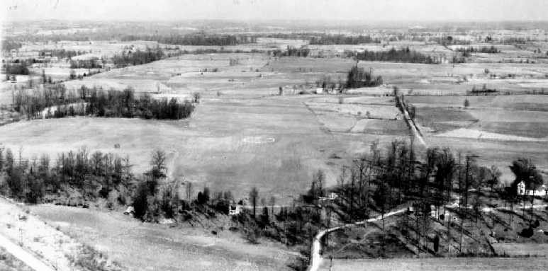
The last photo which has been located of Gill-Dove Field was a 4/12/46 aerial view looking west.
It depicted a hangar & office building next to a grass airfield, with 4 planes visible on the field.
The 1950 USGS topo map depicted Gill Dove Landing Field as an open area with 2 buildings along the east side.
A 3/18/50 aerial view depicted Gill-Dove as having 2 grass runways, with 2 buildings at the southeast corner.
No aircraft were visible on the field.
A 1951 aerial view depicted Gill-Dove in an unchanged fashion.
According to the book “The Aviation History of Tennessee” by Jim Fulbright (courtesy of David Stevenson),
“Gill-Dove Field operated as a publicly licensed facility through the 1960s.”
The last depiction which has been located of Gill-Dove Field on the January 1968 Nashville Sectional Chart.
It depicted Gill-Dove Field as having a 2,700' unpaved runway.
Gill-Dove Airport was apparently closed (for reasons unknown) at some point in 1968,
as it was no longer depicted on the July 1968 Nashville Sectional Chart.
The 1983 USGS topo map still labeled the site as Gill Dove Landing Field.
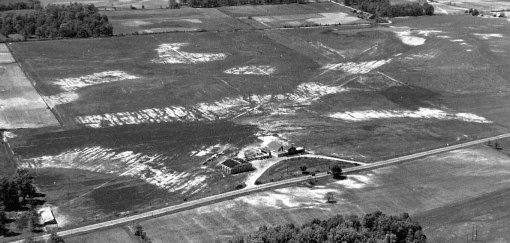
In 1996-97 Westview High School & a complex of athletic fields was built over the site of Gill Dove Field.
Don Coady reported, “I teach at [Westview] high school & was present when the school & park was built in 1996-97;
quite a bit of buried debris from the field was dug up during construction.”
A 1997 aerial view showed that Westview High School & the athletic fields covered the site, erasing any trace of Gill Dove Field.
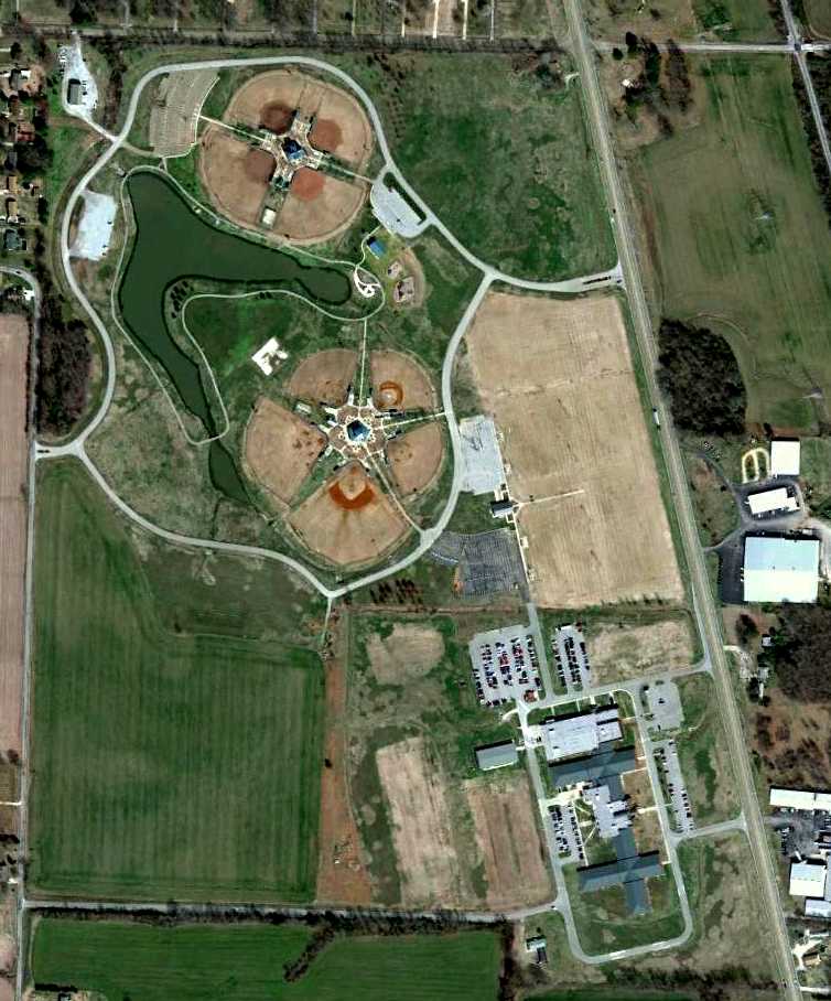
A 2/29/12 aerial view did not show any recognizable trace of Gill Dove Field.
The site of Gill-Dove Field is located southwest of the intersection of Route 43 & Stella Ruth Road.
____________________________________________________
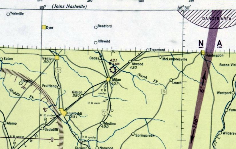
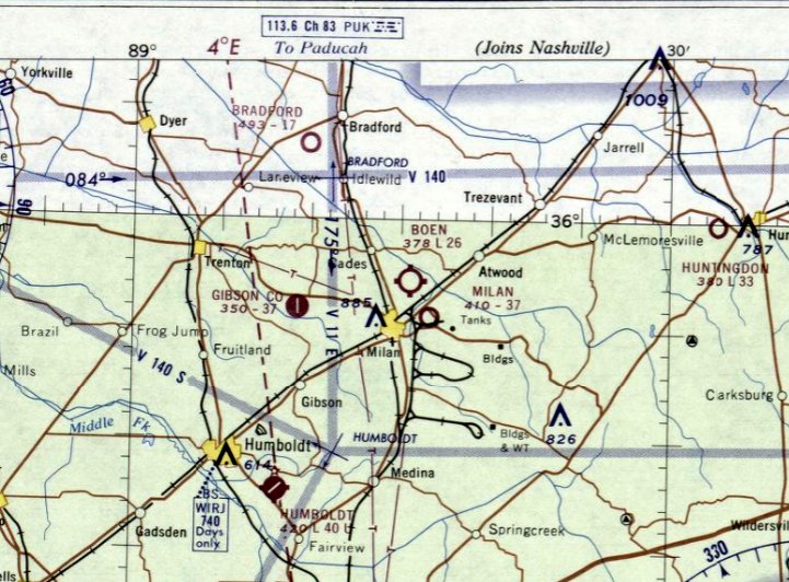
Boen Field / Milan Municipal Airport, Milan, TN
35.96, -88.74 (West of Nashville, TN)
A 3/18/36 aerial view of Milan Airport.
Milan Airport was not yet depicted on the January 1936 Chattanooga Sectional Chart.
According to the book “The Aviation History of Tennessee” by Jim Fulbright (courtesy of David Stevenson),
“The airport at Milan was originally constructed in 1936 & maintained as a Civil Aeronautics Administration auxiliary airfield.”
The earliest photo which has been located of Milan Airport was an 3/18/36 aerial view,
showing 2 grass runways with an airport circular marking at the intersection.
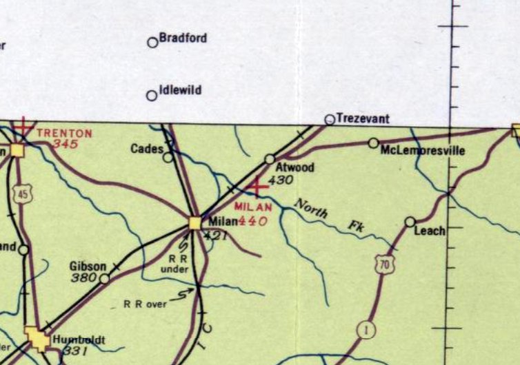
The earliest aeronautical chart depiction which has been located of Milan Airport was on the September 1936 Chattanooga Sectional Chart.
It depicted Milan Airport as an auxiliary airfield, located east of Route 79 & northeast of the North Fork, which is a somewhat different location than later depictions.
The February 1937 Chattanooga Sectional Chart depicted Milan Airport about a mile further southwest compared to the 1936 chart, southwest of the North Fork.
Did the airport move locations, or was this an inaccuracy by mapmakers of the time?
Milan Airport was still depicted on the July 1940 Chattanooga Sectional Chart.
According to the book “The Aviation History of Tennessee” by Jim Fulbright (courtesy of David Stevenson),
“It was seldom used until the Boen family developed it into a private airfield in 1941.”
Milan Airport was no longer depicted on the January 1942 Chattanooga Sectional Chart.
Milan Airport once again was depicted on the March 1944 Chattanooga Sectional Chart, as a commercial/municipal airport,
but depicted at a location a mile to the north of previous depictions, on the opposite side (northwest) of Route 79.
According to the book “The Aviation History of Tennessee” by Jim Fulbright (courtesy of David Stevenson),
“In 1946 the airport became a municipal facility by agreement between the private property owner & the City of Milan.
The airfield was located 2 miles north of town & consisted of 2 intersecting turf runways.”
Bruce Bowen reported, “I am restoring a 1946 Piper J-3 [N92313] that was delivered to Boen Airfield [Milan Airport] in April 1946.
The log books show entries for many years by Arne, Eric, and Raold Boen.”
A 1947 aerial view depicted Milan Airport as having 2 grass runways,
with 3 light aircraft & a small building on the east side of the field.
According to the book “The Aviation History of Tennessee” by Jim Fulbright (courtesy of David Stevenson),
“With financial assistance from the city, a hangar was erected & other improvements completed in the late 1940s.”
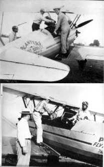
Two early 1950s photos of an unidentified biplane of Planters Flying Service, used to spray for mosquitos, at the Milan Airport.
Pictured are Eric Boen, Harry Paulus, and Mayor Floyd Burrow.
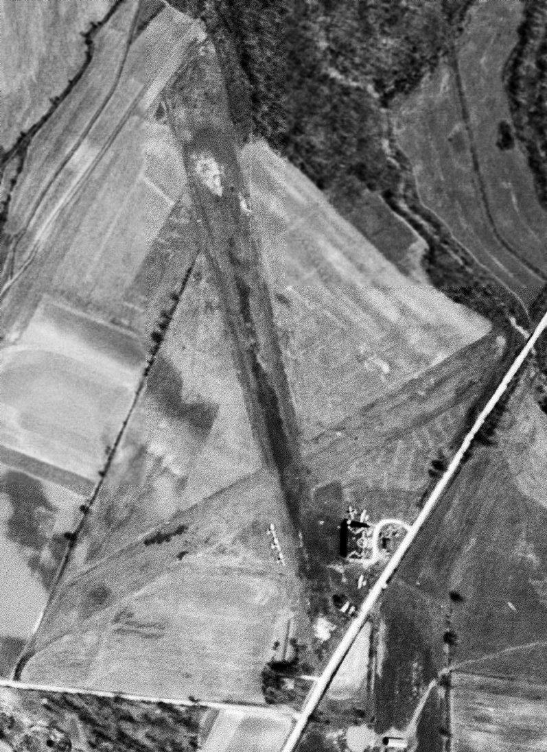
The last photo which has been located showing aircraft at Milan Airport was a 4/17/51 USGS aerial view.
It depicted Milan as having 2 unpaved runways, with some small buildings & 6 single-engine aircraft on the east side of the field.
It was still depicted as Milan Airport on the August 1958 Chattanooga Sectional Chart.
Milan Airport was evidently renamed Boen Field at some point between 1958-59,
as that is how it was depicted on the February 1959 Chattanooga Sectional Chart, with a 2,600' unpaved runway.
A 1960 aerial view no longer depicted the northeast/southwest runway,
and no aircraft were visible on the field, but the hangar remained standing.
According to the book “The Aviation History of Tennessee” by Jim Fulbright (courtesy of David Stevenson),
“By the early 1960s the airport was in state of disrepair, and flying activity was practically non-existent.
It remained unlicensed until March 1964 when Lawrence Browning became manager
and the airport again qualified for licensing as a public airport.”
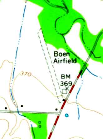
The 1966 USGS topo map depicted Boen Airfield as having a single unpaved northwest/southeast runway,
and 3 small buildings along the southeast side.
According to the book “The Aviation History of Tennessee” by Jim Fulbright (courtesy of David Stevenson),
“When Browning moved his operation to the new Milan-Trenton, Gibson County Airport in 1966, Boen Field was abandoned.”
The last aeronautical chart depiction which has been located of Boen Field was on the August 1966 Chattanooga Sectional Chart.
It depicted Boen Field as having a 2,600' unpaved runway.
Boen Field was no longer depicted on the February 1967 Chattanooga Sectional Chart.
A 1997 aerial view showed the hangar had been removed at some point between 1960-97.
The airfield area remained a clear field, but the runways were no longer recognizable.
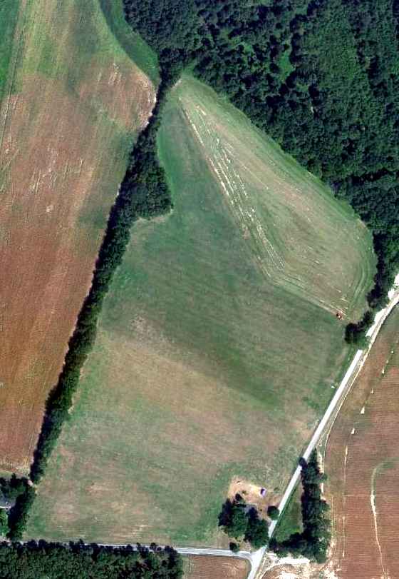
An 8/29/11 aerial view did not show any recognizable trace of the Milan Airport.
The site of Milan Airport is located northwest of the intersection of James Burrow Road & Milan Airport Road, appropriately enough.
____________________________________________________
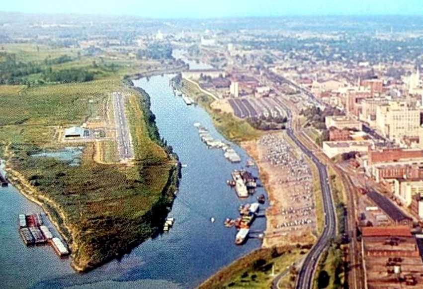
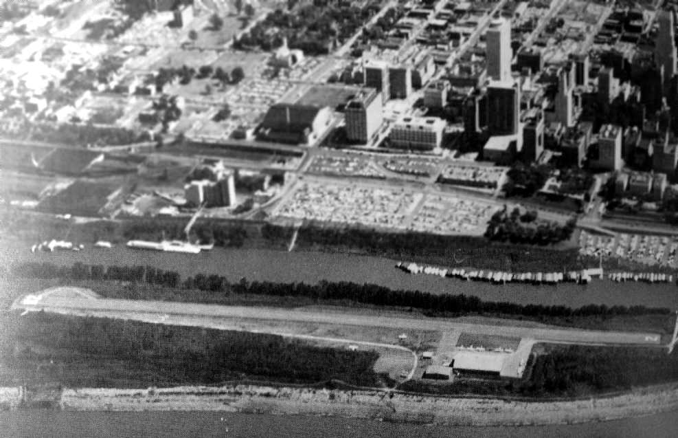
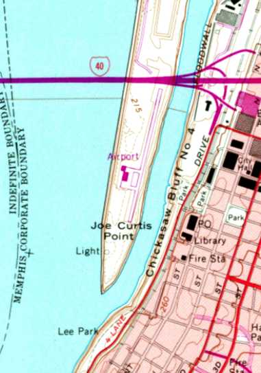
Memphis Downtown Airport / Mud Island Airport, Memphis, TN
35.15, -90.06 (West of Downtown Memphis, TN)
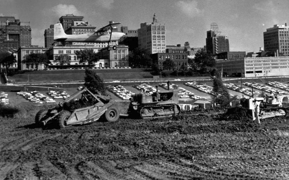
An October 1958 photo of a Cessna flying low over Memphis Downtown Airport, still under construction.
No airfield was yet depicted at this location on the 1954 Little Rock Sectional Chart.
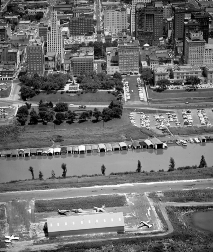
A 1958 aerial view looking east at Mud Island Airport (courtesy of Rob Grant),
with 5 light aircraft parked around hangar next to the runway, with the Memphis skyline in the background.
According to the book “The Aviation History of Tennessee” by Jim Fulbright (courtesy of David Stevenson),
Memphis Downtown Airport was dedicated on 10/3/59 on Mud Island, right across the river from downtown Memphis.
It featured a 3,100' paved runway, and was said to be the first airport in the nation built so close to a downtown.
The airport was owned by the City of Memphis & leased for operation.
The first tenant operator was Downtown Airport Inc.
The airport was used by business travelers who appreciated its convenience to downtown Memphis,
and it featured a pontoon ferryboat for the 300' trip to the mainland.
It even had a great slogan: “You’re strictly uptown when you land downtown.”
A circa 1959 aerial view looking north at Memphis Downtown Airport
showed a single paved north/south runway, with a ramp & hangar on the southwest side.
The earliest aeronautical chart depiction which has been located of Memphis Downtown Airport was on the February 1960 Little Rock Sectional Chart,
which depicted Downtown as having a 3,000' paved runway.
A 1960 aerial view looking east showed 9 light aircraft visible at Memphis Downtown Airport (courtesy of David Stevenson).
By 1961, Mud Island Airport was conducting 30 landings per day, according to newspaper reports.
A 3/8/63 USGS aerial view showed Memphis Downtown Airport having a single asphalt northeast/southwest runway,
with a few small buildings & 9 single-engine aircraft on the southwest side.
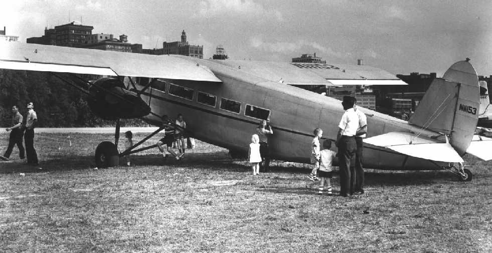
A circa 1964-70 photo of a 1931 Stinson SM-6000 Tri-Motor on the grass at Mud Island Airport.
According to the book “The Aviation History of Tennessee” by Jim Fulbright (courtesy of David Stevenson),
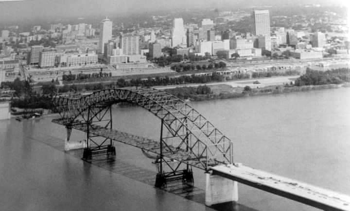
after only a mere 6 years of operation, a bitter fight to save Memphis Downtown Airport began in 1965,
when a new bridge across the Mississippi River was proposed,
which would extend directly over the north end of the runway.
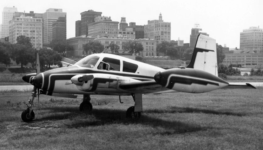
The last ground-level photo which has been located showing Mud Island Airport still open was a 1966 photo by Nick Williams of 1956 Cessna 310 N639F c/n 35400.
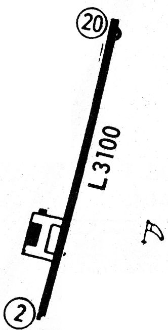
The 1968 Flight Guide (courtesy of Robert Levittan) depicted Memphis Downtown Airport
as having a single paved 3,100' Runway 2/29, with a ramp & 2 buildings on the southwest side.
The last aeronautical chart depiction which has been located of Memphis Downtown Airport was on the December 1968 Memphis Sectional Chart (courtesy of Ron Plante),
which depicted Downtown as having a 3,100' paved runway.
The last depiction which has been located showing Mud Island Airport still open was on the 1970 USGS topo map.
It depicted a single paved north/south runway,
with a ramp & 2 buildings on the southwest side, all labeled simply as “Airport”.
Note the proximity of the Route 40 bridge which had been built directly across the north end of the runway,
spelling the end for this convenient downtown airport.
According to the book “The Aviation History of Tennessee” by Jim Fulbright (courtesy of David Stevenson),
Memphis Downtown Airport was closed on 8/13/70, and big yellow closed-runway X markings were painted on the runway.
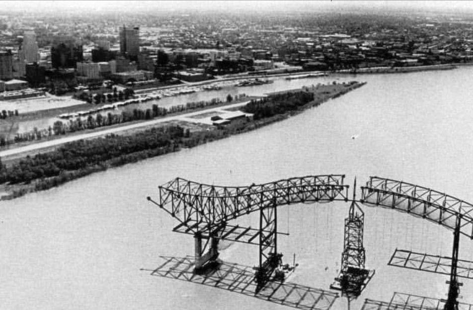
A circa 1971 aerial view looking southeast at Mud Island Airport (courtesy of Jim Rice), with the Hernando Desoto bridge under construction in the foreground, the cause of the airport's closure.
The airport appeared to be closed, with no aircraft or vehicles evident.
A circa 1971 aerial view looking southeast at Mud Island Airport (courtesy of Jim Rice), with the Hernando Desoto bridge under construction in the foreground, the cause of the airport's closure.
The airport appeared to be closed, with no aircraft or vehicles evident.
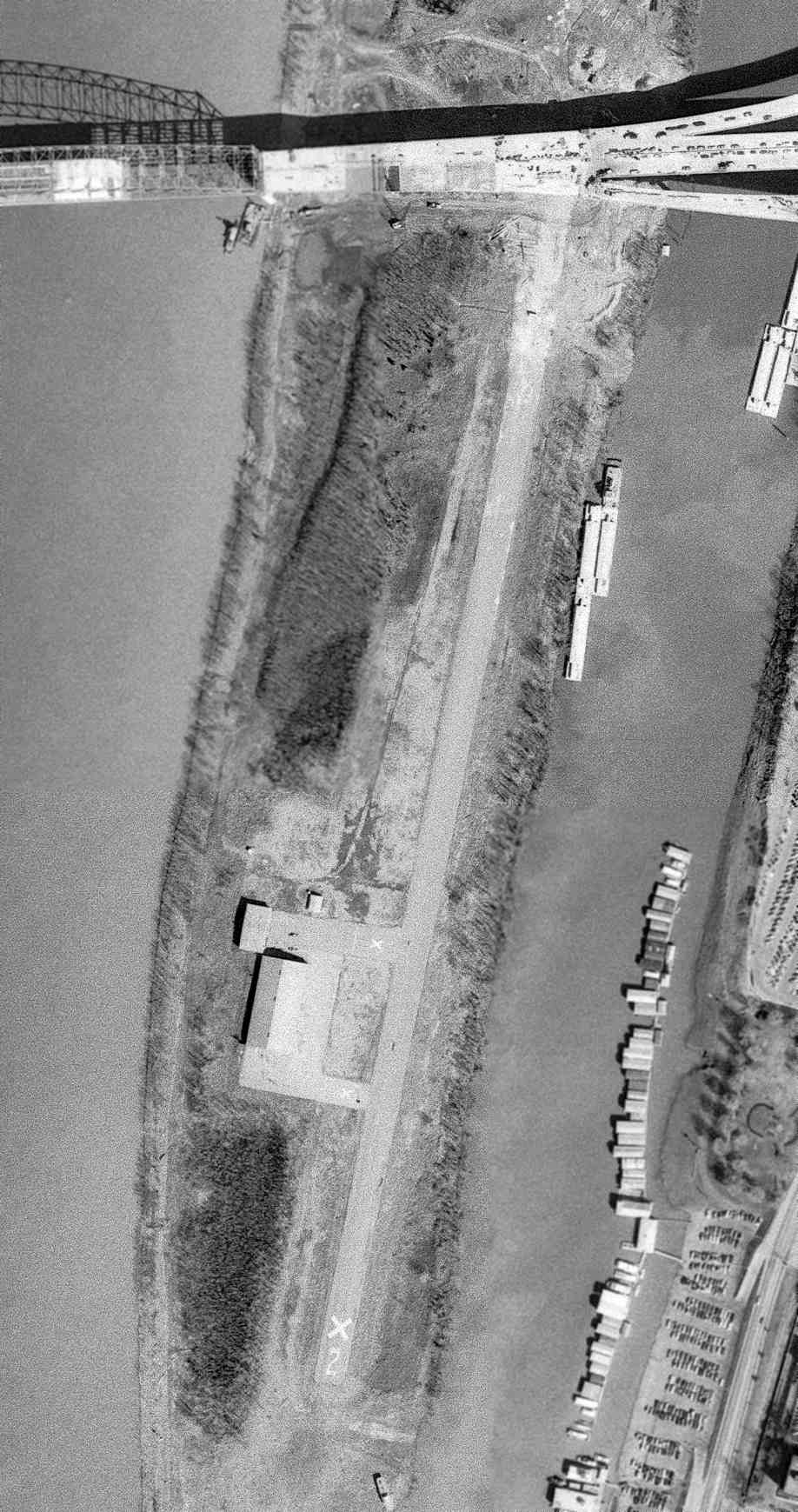
The last depiction which has been located of Mud Island Airport was on a 3/8/73 USGS aerial view.
The runway & airport buildings were still intact, though the runway & taxiway were marked with closed “X” symbols.
Mud Island Airport was depicted as an abandoned airfield on the November 1974 Memphis Sectional Chart (courtesy of Ron Plante).
At some point between 1973-87 the Mud Island Airport site was converted into a park.
Mud Island saw one more aviation use, when in 1987 the historic B-17 bomber “Memphis Belle”
was installed for display in a new pavilion with large tarp cover located on the northern portion of the Mud Island Airport site.
A 1997 aerial view showed no trace remaining of the Mud Island Airport.
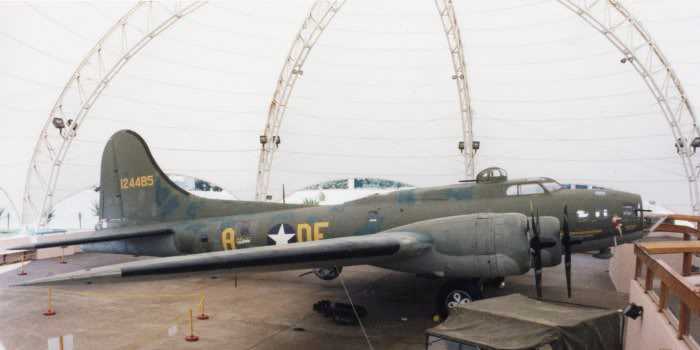
A 1999 photo of the B-17 “Memphis Belle” under its tarp on Mud Island.
The vintage B-17 was still open to the elements & prone to weathering.
Dissatisfaction with the site led to the Memphis Belle being disassembled and removed from Mud Island for restoration in 2003.
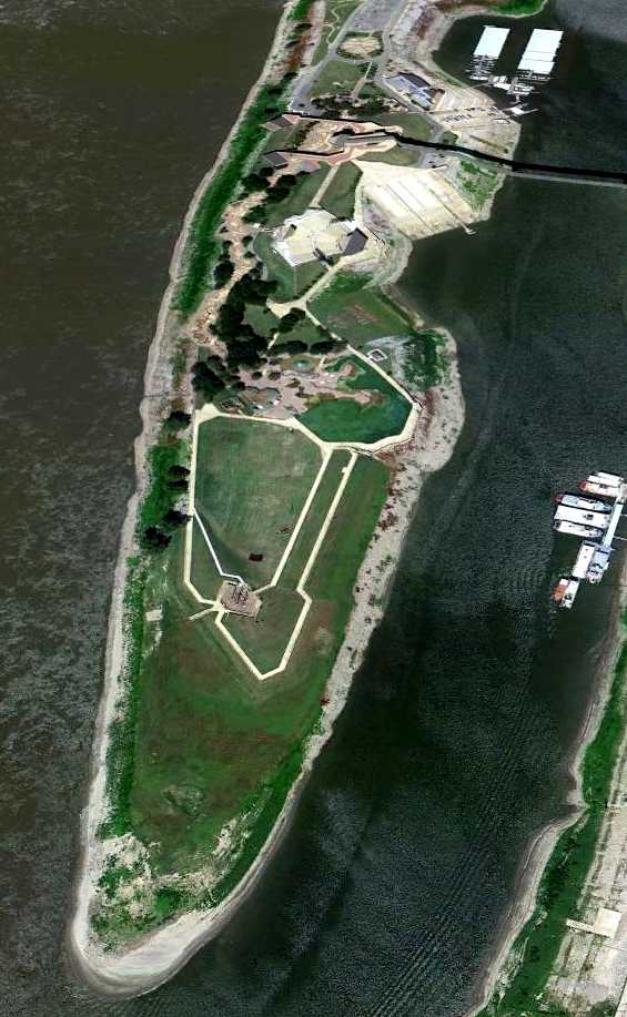
A 2011 aerial view looking north showed no trace remaining of the Mud Island Airport.
The site of Mud Island Airport is located south of the intersection of Interstate 40 & Island Drive.
____________________________________________________
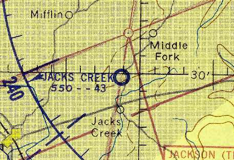
Jacks Creek Intermediate Field, Jacks Creek, TN
35.5, -88.52 (Southwest of Nashville, TN)
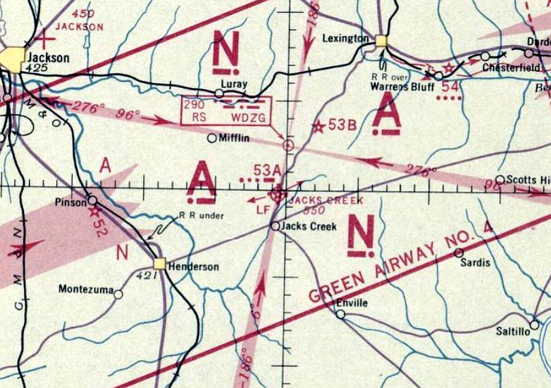
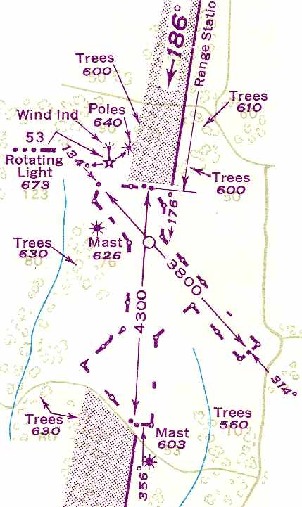
Jacks Creek Intermediate Field, as depicted on the August 1939 Chattanooga Sectional Chart.
Jacks Creek Intermediate Field was one of the Department of Commerce's network of Intermediate Fields
which were constructed along airways between major cities, for the emergency use of commercial aircraft.
According to the book “The Aviation History of Tennessee” by Jim Fulbright (courtesy of David Stevenson),
“The lighted airway beacon & emergency field that had once been located in Chesterfield [was] reestablished near Jacks Creek.
The Jacks Creek airfield consisted of a 5,000' runway.
Facilities included a radio range approach system, a weather station & a communications building.
On 8/13/38 local citizens held an airport grand opening which featured aerobatics & parachute jumps.”
Jacks Creek Intermediate Field was not yet listed among active airfields
in The Airport Directory Company's 1938 Airport Directory (according to Chris Kennedy)
nor depicted on the March 1939 Chattanooga Sectional Chart.
The earliest depiction of the field which has been located was on the August 1939 Chattanooga Sectional Chart.
It depicted Jacks Creek as being Site 53A along the airway.
The Airport Directory Company's 1941 Airport Directory (courtesy of Chris Kennedy)
described Jacks Creek as being Site 53A along the Dallas-Louisville airway.
The field was said to consist of an irregularly-shaped sod field having three runways,
of which the longest was the 4,300' north/south strip.
The field was said to be illuminated, but to offer no other services.
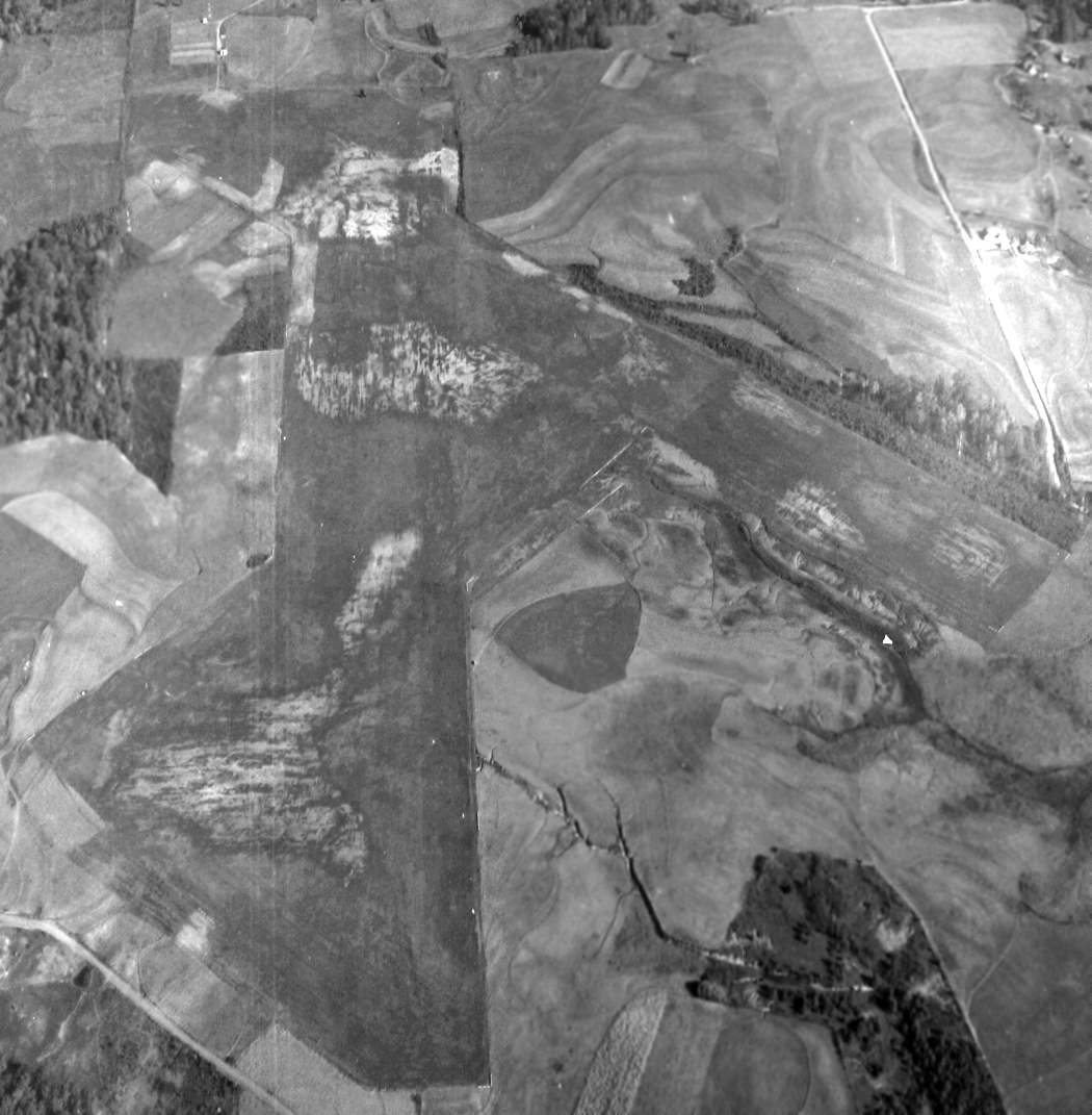
The only photo which has been located of Jacks Creek Intermediate Field from when it was operational
was a 10/28/43 National Archives aerial view looking north (courtesy of Brian Rehwinkel).
It depicted Jacks Creek as having 3 unpaved runways.
The April 1944 U.S. Army & Navy Directory of Airfields (courtesy of Ken Mercer)
described Jacks Creek as Site 53 along the Dallas-Louisville Airway,
and described the field as having a 4,300' unpaved runway.
The 1945 AAF Airfield Directory (courtesy of Scott Murdock) described Jacks Creek Intermediate Field
as a 133 acre irregularly-shaped property having 3 sod runways, the longest being a 4,300' north/south strip.
The field was not said to have any hangars,
to be owned by private interests, and operated by the Civil Aeronautics Administration.
The 1948 USAAF Pilot's Handbook (courtesy of Chris Kennedy)
depicted Jacks Creek as an unpaved airfield having two runways: 4,300' north/south & 3,800' northwest/southeast.
According to the book “The Aviation History of Tennessee” by Jim Fulbright (courtesy of David Stevenson),
“The weather station remained at Jacks Creek until the late 1940s
when it was moved to Jackson's McKellar Field.”
The last aeronautical chart depiction which has been located of Jacks Creek
was on the August 1956 Chattanooga Sectional Chart (courtesy of Chris Kennedy).
It depicted Jacks Creek as a public-use airport having a 4,300' unpaved runway.
According to the book “The Aviation History of Tennessee” by Jim Fulbright (courtesy of David Stevenson),
“When the U.S. Department of Commerce lease ran out in 1956,
all other equipment was removed & the land returned to farming.”
This was quite a bit longer than most Intermediate Fields lasted,
as their need had been obviated by advances in the range & reliability of commercial aircraft.
Jacks Creek Intermediate Field was no longer depicted on the January 1961 Chattanooga Sectional Chart (according to Chris Kennedy).
USGS topo maps from 1979, 1986, and 1989 did not depict anything at all at the location of the airfield.
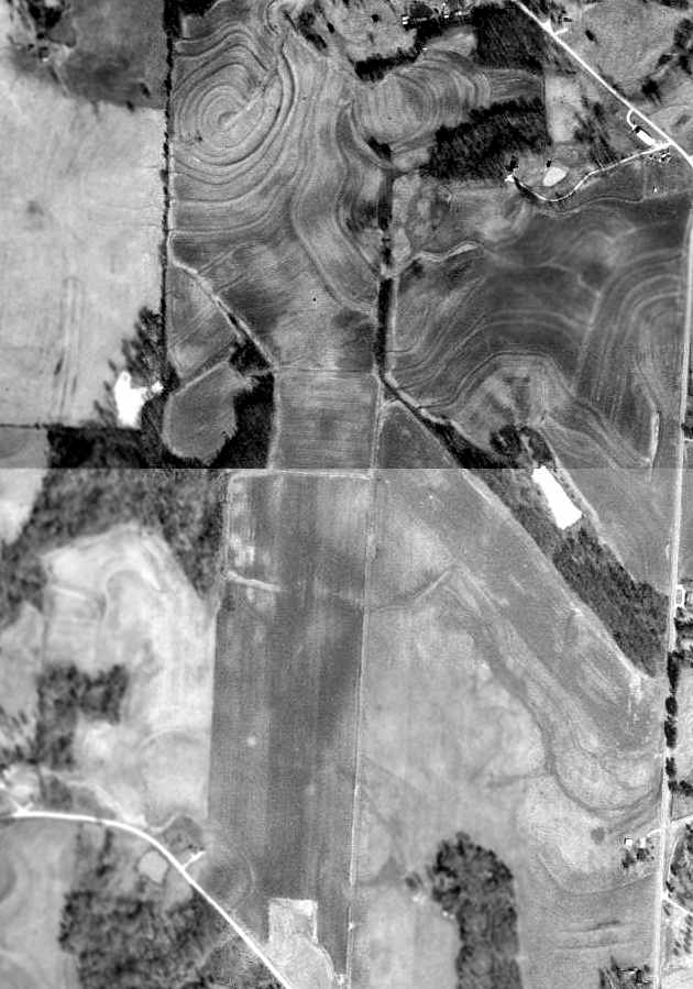
As seen in the 1997 USGS aerial photo, the outline of the 2 former runways at Jacks Creek was still recognizable.
The site of Jacks Creek Intermediate Field is located southwest of the intersection of Route 22A & Jones Road.
____________________________________________________
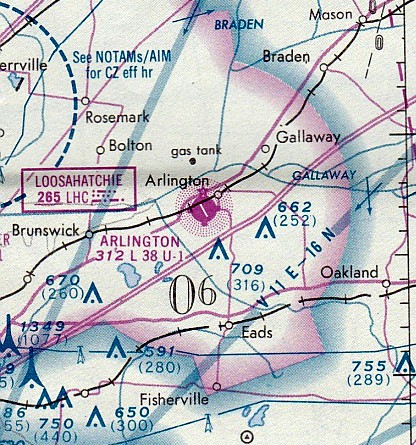
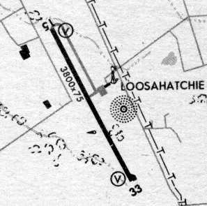
Arlington Municipal Airport (LHC), Arlington, TN
35.28, -89.67 (Northeast of Memphis, TN)
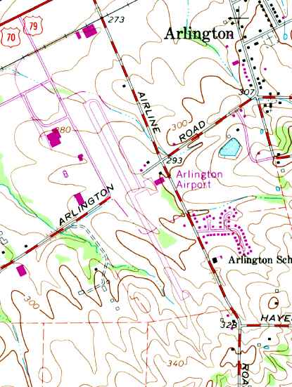
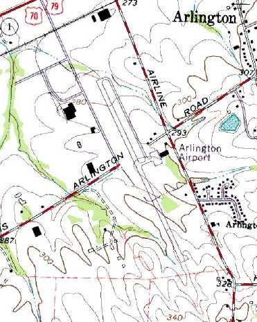
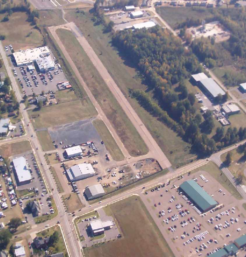
Arlington Airport, as depicted on the 1973 USGS topo map.
This is the story of yet another well-used general aviation airport
which has been swallowed up by surrounding development.
It lasted a mere 30 years - not a very long time for a taxpayer investment.
The Arlington Municipal Airport was not yet depicted on the 1965 USGS topo map or the August 1968 Chattanooga Sectional Chart.
According to a report by the University of Memphis, the Arlington Municipal Airport was constructed in 1968
as a result of a grant agreement between the Federal Aviation Administration & the Town of Arlington.
A hangar & terminal were added the following year with the State of TN sharing the cost with the Town of Arlington.
The Arlington airport was in operation by 1969.
According to the book “The Aviation History of Tennessee” by Jim Fulbright (courtesy of David Stevenson),
“The airport was formally dedicated 9/29/70 with a fly-in & airshow sponsored by the Arlington Lions Club.”
The earliest depiction which has been located of Arlington Municipal Airport was on the 1973 USGS topo map.
It depicted Arlington Municipal as having a single northwest/southeast paved runway.
The earliest aeronautical chart depiction which has been located of Arlington Airport
was on the November 1974 Memphis Sectional Chart (courtesy of Ron Plante).
It depicted Arlington as having a 3,800' paved northwest/southeast runway.
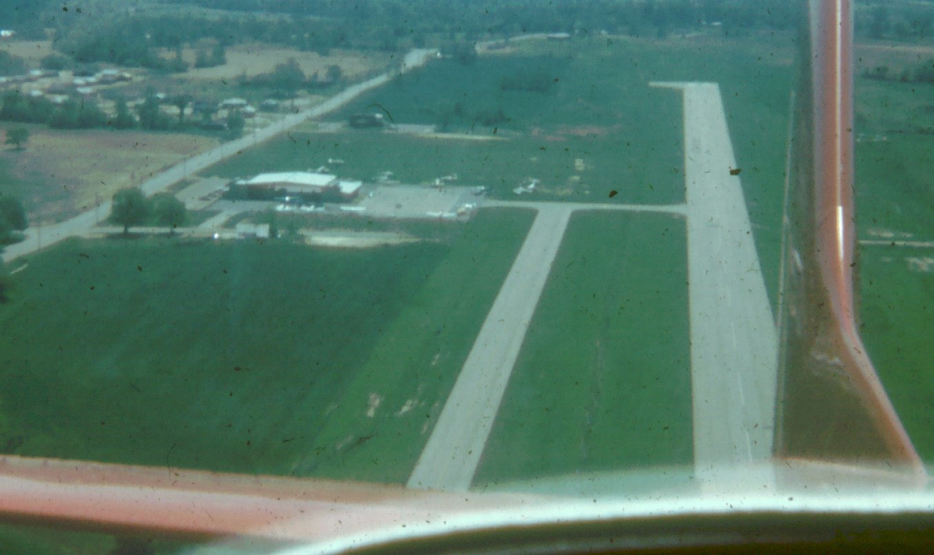
The earliest photo which has been located of Arlington Airport was an early 1972 aerial view by Timothy Miller looking southeast.
It depicted Arlington as having a single northwest/southeast paved runway, with a paved parallel taxiway, and a ramp, hangar, and several light planes parked nearby.
Timothy recalled, “In 1972 I was 18 & I would ride my bicycle out the the NAS Memphis Flying Club & hitch rides with the guys. Arlington was a good place to do touch & goes.”
The 1981 DoD VFR Supplement (courtesy of John Clifford) depicted Arlington Municipal as having a single 3,800' asphalt Runway 15/33.
The 1981 USGS topo map depicted Arlington Airport as having a single paved northwest/southeast runway,
with a parallel taxiway leading to a ramp with a single hangar on the east side.
The 1982 AOPA Airport Directory (courtesy of Ed Drury) listed the operators at Arlington Municipal as Shamrock Aero, Jewel Aircraft Engine Overhaul,
Ken Guthrie Aircraft Sales, and Starflight Inc.
Local pilot Bill Zollinger reported that "I don't recall if Shamrock Aero was there from the beginning
but it was certainly there by the mid-1970s & continued at least until the late 1980s.
It was owned by Dr. Sam Hardison, a local dentist, and the manager was Gary Miller.
John Jewell came along about 1977 & opened an engine overhaul shop there.
Richard Starnes had a general maintenance shop. Jack Adams Aircraft Sales had an office there before Ken Guthrie.
Ken arrived about 1980 or so."
Bill continued, "In the late 1960s the mayor, Sam Yorty, lead a coalition of the town council to fund the airport & an adjoining industrial park.
The two were supposed to complement each other.
The town as a sleepy bedroom community of Memphis never fully accepted or realized the value of either but at least the industrial park was quiet.
First they pushed Shamrock out for bringing in too much business (noise)
and then they hired a retired FedEx flight engineer to run the place.
He told them he would get the registration of any noisy aircraft & have the FAA punish them.
He lasted 3-4 years & they brought in East Memphis Aviation as a lame duck
whereupon they jerked the rug & airport out from underneath him after not accepting any more aid money
and waiting the proscribed period after which they are no longer liable.
Then they made sure to place things on the ex-runway to ensure no further use even as an emergency airfield.
What they failed to take into account (other than the obvious)
is that Memphis is growing in their direction & within a very few years will completely surround them.
This will bring 24 hour grocery stores & the other bustle & noise from the 'big' city to them.
If they had paid a little more attention to their economic base
and planned to grow their town they would at least have minimized this effect."
A 1985 photo taken while Gary Burlison was on final approach to Arlington's Runway 33.
Gary recalled, “I received my private certificate in July 1985.
My instructor's name was Jim Dotson; he worked there 8-10 years.”
The last aeronautical chart depiction which has been located of Arlington Airport
was on the 1985-86 TN Aeronautical Chart (courtesy of Alex Hauzer).
It depicted Arlington as having a 3,800' paved northwest/southeast runway.
As of 1998, Arlington Municipal was apparently a quite well-used airport, with a total of 51 resident aircraft,
and conducting an average of 94 takeoffs or landings per day.
The fixed base operator was Memphis East Aviation.
Chris Lobdell recalled, “I learned to fly at KLHC in Arlington in the late 1990s. The Fixed Base Operator where I took my first lessons [was] East Memphis Aviation.”
A 1998 USGS aerial view looking northwest showed Arlington Municipal Airport to have a 3,800' paved runway,
parallel taxiway, and a ramp with 2 hangars on the east side.
A total of 29 light aircraft were visible parked outside.
In spite of this relative health, the town of Arlington had the University of Memphis
conduct a "cost/benefit analysis" of whether or not to close their airport in 1998.
Guess what? The result of their "cost/benefit analysis" was to close the airport -
which was probably a foregone conclusion that the "analysis" was intended to support.
By selling the 102 acre municipal property to developers (who rarely have any connection to local politicians, right?),
the town government was able to realize a substantial short-term financial gain,
regardless of the long-term loss of a municipal asset (which was partially paid for by both federal & state taxpayers).
Rhea Palmer recalled, "My husband & I spent a lot of time out at Arlington Airport.
We were there when it was closed & it was a fiasco!
A.I. Guron was the man running it at the time. I have fond memories of that airport.
My husband asked me to marry him at the end of Runway 15."
Thomas Oehl helped to narrow down the date of closure of Arlington Municipal.
He recalled, “I was based at Arlington Airport when it closed. I moved my aircraft the day I was notified.
My son, who I was giving flight instruction to at the time, has a more accurate logbook.
His last flight at LCH was March 27 & his next solo flight was 4/9/99 at the Millington Charles Baker Airport, our new home base.”
Chris Lobdell observed, “It's a shame that development & short-sighted politicians caused the closure of the airport.”
Arlington Municipal was depicted as an abandoned airfield on the April 1999 Memphis Terminal Aeronautical Chart (courtesy of Ron Plante).
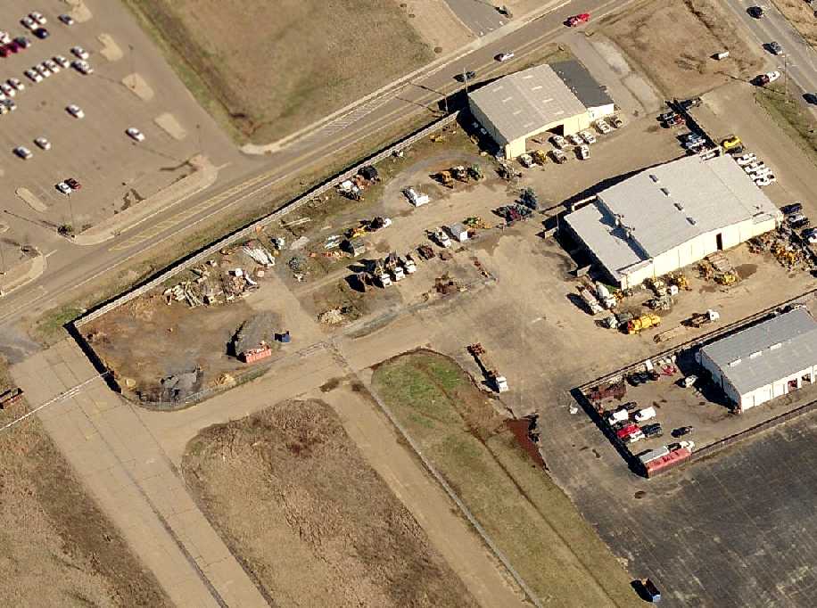
A 2006 aerial view by Damon Morris looking south at the remains of the Arlington Municipal Airport.
The southern half of the runway & taxiway remain intact, while new construction covers the northern portion.
The former ramp & several hangars also remain intact.
A circa 2007 aerial view looking north at the former hangars & runway remains of the Arlington Municipal Airport.
A 2012 photo looking southeast along the remains of the Arlington Municipal Airport runway.
A 2012 photo looking west at a former Arlington Municipal Airport hangar.
An 8/9/13 aerial view by Jim Rice taken from his J-3 Cub looking south at the remains of the southern end of Arlington Municipal Airport.
Jim observed, “Only a small part of the runway & taxiway remain. The hangar is still intact.”
A 2018 aerial photo showed the former Arlington Municipal Airport hangar was removed at some point between 2013-2018.
Arlington Municipal airport is located south of the intersection of Route 70 & Airline Road, appropriately enough.
____________________________________________________
Naval Outlying Landing Field 15305, Ellendale, TN
35.29, -89.83 (Northeast of Memphis, TN)
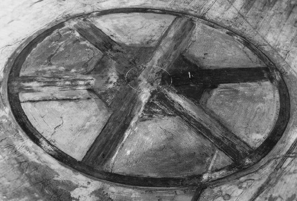
A 3/23/43 U.S. Navy aerial view of NOLF 15305 (courtesy of Brian Rehwinkel).
According to Brian Rehwinkel, “Memphis OLF #15305 (also known as Site 15)
was one of at least 16 outlying fields used by NAS Memphis [5 miles northwest] during the Second World War.”
The designation of Naval Outlying Land Field 15305
refers to its bearing from the parent Naval Air Station, NAS Memphis (153 degrees) and its distance (05 miles).'
According to Brian Rehwinkel, “The field was first leased in late 1942 or early 1943.
A 12/31/44 Outlying Field Report for NAS Memphis described the field with a 'stabilized' landing mat with 3 runways
(It is likely the field was originally a grass field).”
NOLF 15305 was not depicted at all on the March 1944 Chattanooga Sectional Chart (courtesy of Chris Kennedy).
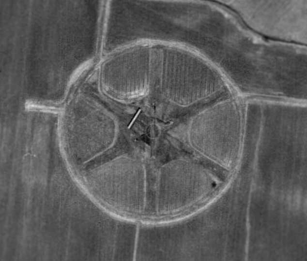
The earliest depiction of the field which has been located was a 3/23/43 U.S. Navy aerial view (courtesy of Brian Rehwinkel).
Brian observed it showed “the field, apparently shortly after the landing mat was added.
Erosion seems to be a bit of a problem.”
It showed the field to consist of a distinctive “wagon wheel” configuration,
with 3 paved runways extending from a central landing mat, surrounded by a paved circular ring.
Many of Memphis' satellite airfields were built in this same "wagon wheel" airfield configuration.
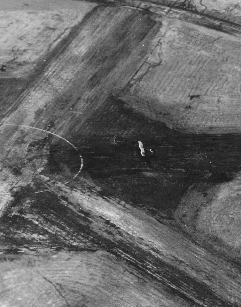
A closeup from the 3/23/43 U.S. Navy aerial view (courtesy of Brian Rehwinkel), showing a biplane trainer near the center of the field.
The earliest aeronautical chart depiction which has been located of NOLF 15305
was on the April 1945 Chattanooga Sectional Chart.
It depicted 13305 as an auxiliary airfield.
According to Brian Rehwinkel, “The Navy [acquired] title to the field in May 1945.
The Navy purchased the land for this field (and the land for the other 4 hard-surfaced outlying fields)
because of the considerable investment made in putting stabilized landing mats on these fields in order to make them 'all-weather' landing areas.
After the war, this field – and the 4 other paved fields – was retained for a period after the war.”
The October 1946 Chattanooga Sectional Chart (courtesy of Chris Kennedy)
depicted NOLF 15305 as an auxiliary airfield.
A circa 1947 Navy document (courtesy of Brian Rehwinkel) described the runway as a
“one inch wagon wheel shaped asphalt pavement on a 6 inch sub base.”
The document went on to describe the 1,200' runways in “poor” condition.
The last aeronautical chart depiction which has been located of “15305 (Navy)”
was on the February 1950 Chattanooga Sectional Chart.
NOLF 15305 was evidently abandoned at some point between1950-55,
as it was no longer depicted at all on the February 1955 Chattanooga Sectional Chart.
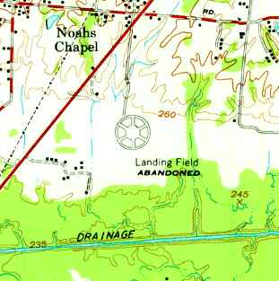
The wagon wheel runway layout of NOLF 15305 was still depicted on the 1960 USGS top map,
labeled as “Landing Field Abandoned”.
Local pilot Bill Zollinger recalled that "The 'Wagon Wheel' at Ellendale was a common landmark
to those of us flying from Shelby County airport.
There was a lot of speculation about whether engine out training
was allowed to progress to the point of actually doing a touch & go on it.
I came close but never actually touched down.
There was also speculation that the wagon wheel was the very site, or certainly close by,
that Phoebe Omilie & her husband used as part of the process of bringing air mail to the Memphis area."
Skip Robertson recalled, “I was in a [model airplane] club that used the field in the early 1970's until around 1976.
I believe that it was in 1976 that the club lost it's lease there.”
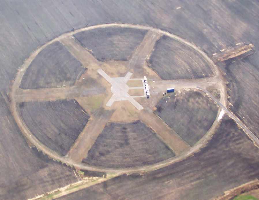
As seen in the 1997 USGS aerial photo,
the airfield at Ellendale consists of three 1,300' runways, arranged evenly around the compass,
with a circular track running around the periphery.
This runway configuration was ideal for primary flight cadets,
as it allowed a landing to be made with minimal crosswind component regardless of the prevailing wind direction.
The runways of the former airfield are still remarkably well preserved in the above 1997 aerial photo.
A narrow shed for a model airplane club sits just west of the runway intersection.
Skip Robertson reported, “You can see where we used the center of the two crossed runways...
the X's on them are still a little visible.
I believe that they were concrete at the time.
You can also see the 3 taxiways from the pit area...one at each end and one in the center.”
Recent USGS topo maps did not depict anything at all at the location of the airfield.
Jack Estes reported in 2005, “The narrow 'structure' is actually a pilots shed for a local radio-control airplane club.
If you look carefully in the center of the runways, you can see two smaller paved runways that the models fly off of.
We frequently get Stearman traffic, and your occasional 172 shooting an engine out.
Every now & then, a Stearman will touch down.
That is rare though, because the original parts of the runway are very rough rock/grass.”
A 2006 aerial view by Damon Morris looking southwest at the remains of the Ellendale airfield,
showing the model aircraft runways & buildings which have been added over the site of the military airfield.
An August 2011 aerial view by Jim Rice looking southwest at the remains of the Ellendale airfield.
Brian Rehwinkel observed in 2012, “Considering the fact the runways were constructed close to 70 years ago,
it is impressive the outlines can still be seen.
I am guessing the runway surface deteriorated long ago, and what we see today is the remains of the extensive sub base
(particularly considering the fact the runways were apparently in poor condition way back in 1947).”
NOLF 15305 is located one mile east of Route 14, four miles north of Ellendale, TN.
____________________________________________________
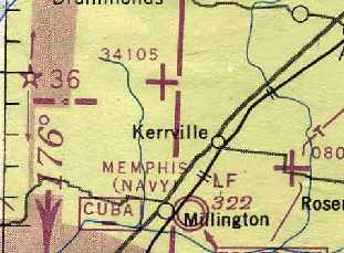
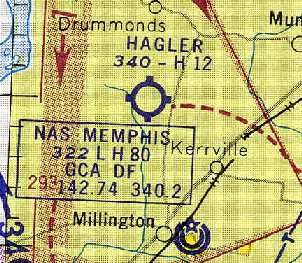
Naval Outlying Landing Field 34105 / Hagler Airport, Wilkinsville, TN
35.415, -89.902 (Northeast of Memphis, TN)
A 10/22/43 National Archives aerial view looking north at NOLF 34105 (courtesy of Brian Rehwinkel).
This former military airfield was one of 10 satellite airfields
which were used during WW2 to support NAS Memphis (4 miles southeast),
which was one of the busiest Navy training fields during the war.
Many of Memphis' satellite airfields were built in the same "wagon wheel" airfield configuration.
The designation of Naval Outlying Land Field 34105
refers to its bearing from the parent Naval Air Station, NAS Memphis (341 degrees) & its distance (05 miles).
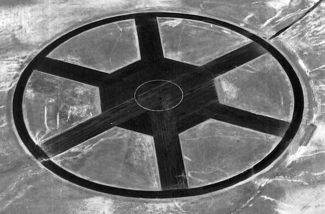
The earliest depiction which has been located of NOLF 34105
was a 10/22/43 National Archives aerial view looking north (courtesy of Brian Rehwinkel).
The photo showed NOLF 34105's wagon-wheel configuration of 6 asphalt runways surrounded by an asphalt ring.
This configuration was designed to ensure that student pilots always had a runway facing into any prevailing wind.
Brian Rehwinkel observed, “I don’t know the date this field opened, but the field appears newly paved in this photo.”
NOLF 34105 was not depicted at all on the March 1944 Chattanooga Sectional Chart (courtesy of Chris Kennedy).
The earliest aeronautical chart depiction which has been located of Field 34105
was on the October 1946 Chattanooga Sectional Chart (courtesy of Chris Kennedy).
NOLF 34105 was most likely abandoned by the Navy quite soon after the end of WW2.
It was not depicted at all on the 1960 USGS topo map.
Richard Douglass recalled, “I was stationed at NAS Memphis during 1960-61, undergoing training to be an aviation electronics technician.
Soon after arriving in June 1960 I heard about a Navy flying club.
I had been in the Civil Air Patrol before joining the Navy, and was already interested in getting a pilot license.
I joined the club & found they flew out of an airport that had been an NAS Memphis auxiliary field during WW2.
In 1960 it was a ramshackle affair in the boondocks run by one A. B. Hagler, who was also one of the flight instructors.
I recall a small shack as an office. Only one 1,200' paved runway was in use, and it had an 800' grass extension at the normal approach end.
We were instructed avoid a touchdown on the grass, because cows often grazed there & left their calling cards.
When the cows were there, that grass extension was fenced off.
Their hooves also sunk into the soil creating bumps & depressions, and in the winter cold especially these factors made the surface quite bumpy.
But it acted as a great approach path to the paved runway.”
Richard continued, “The field was out of the way of other flight activity, offering a perfect place for beginning students to learn.
The 1,200' runway was long enough, but sometimes maddeningly short.
The Cessna 120/140 series was a very clean airplane, and taught students exacting speed control.
If one was 5 MPH too fast on final approach, the bird would just float down the runway in ground effect,
float & not come down, and the amused instructor might laugh as you were forced to go around for another try.
My first flight was on 7/9/60 in a Aeronca Champ, but most were in a club Cessna 120 or 140.
The first few flights are logged as originating from 'Millington'; By October 1960 my log book calls it Hagler's Air Park, and by December we were logging it as Hagler Skyport.
My last flight from there was on 4/23/61, and there was no talk about the place closing down.
The aircraft available to the flying club included at least one Cessna 120, a Cessna 140 and the Champ 7AC.
I think there were a few other airplanes based there, but as I recall the main activity was the instruction of the Navy flying club students.”
The former Navy airfield was depicted as "Hagler" Airport on the 1961 Chattanooga Sectional Chart (courtesy of Chris Kennedy),
and described as having a mere 1,200' paved runway.
Unlike many other small WW2-era outlying fields, this one apparently saw some reuse as a civil airport,
as it was depicted as "Hagler" Airport on the 1961 Chattanooga Sectional Chart (courtesy of Chris Kennedy).
The Aerodromes table on the chart described the field as having two runways:
a 1,200' hard-surface strip & a 2,100' turf strip.
However, Hagler was apparently abandoned at some point between 1961-63,
as it was labeled "Abandoned airport" on the 1963 Chattanooga Sectional Chart (courtesy of Chris Kennedy).
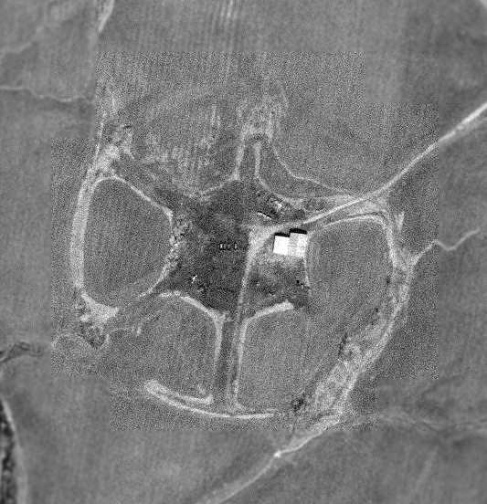
As seen in the 1997 USGS aerial photo,
the airfield at Wilkinsville consists of three 1,300' runways, arranged evenly around the compass,
with a circular track running around the periphery.
The airfield layout is still quite apparent in the above 1997 aerial photo,
although the airfield is somewhat more deteriorated than that at Ellendale.
Two buildings (barns?) have been constructed just east of the runway intersection.
The Wilkinsville airfield is exactly the same configuration as NOLF 15305 in nearby Ellendale.
USGS
topo maps do not depict anything at all at the location of the
airfield.
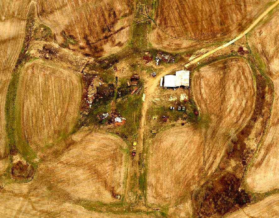
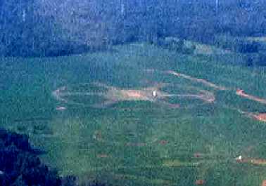
The wagon-wheel layout of the former NOLF 34105 runways was still barely recognizable in a circa 2006 aerial view looking north.
The wagon-wheel layout of the former NOLF 34105 runways was still barely recognizable in 2017 aerial view looking north.
The site of NOLF 34105 is located at the southwestern terminus of Ahaz Armstrong Road, west of Wilkinsville Road.
____________________________________________________
UL>
Or if you prefer to contact me directly concerning a contribution (for a mailing address to send a check),
please contact me at: paulandterryfreeman@gmail.com
If you enjoy this web site, please support it with a financial contribution.
____________________________________________________
This site covers airfields in all 50 states.