
Abandoned & Little-Known Airfields:
New York: Long Island: Eastern Suffolk County
© 2002, © 2025 by Paul Freeman. Revised 12/23/25.
This site covers airfields in all 50 states: Click here for the site's main menu.
____________________________________________________
Please consider a financial contribution to support the continued growth & operation of this site.
Coram Airport (revised 4/18/22) - Flowerfield Airfield (revised 1/15/21) - Grumman Peconic River Airfield / Calverton Executive Airpark (revised 12/23/25)
Lufker Airport (added 9/20/24) - New Sayville Airport (revised 6/18/22) - Sayville Airport (revised 6/18/22) - Spadaro Airport (revised 9/20/24)
____________________________________________________
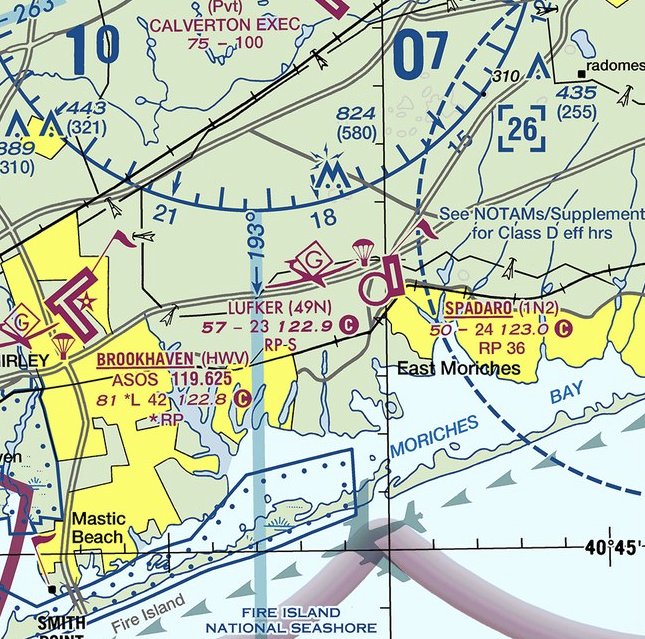
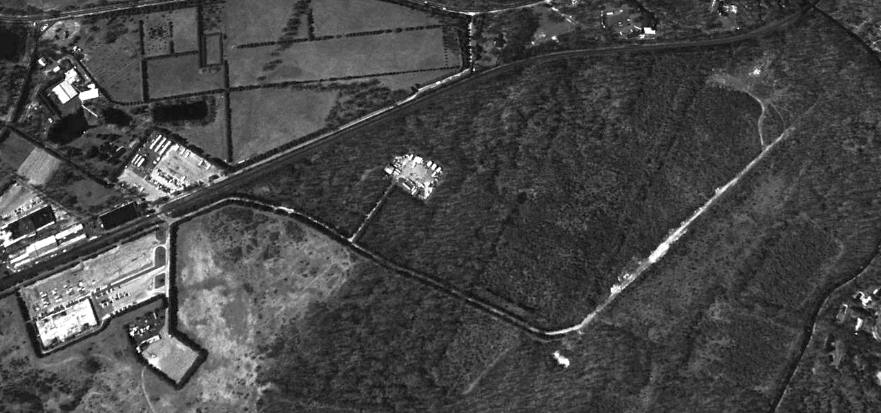
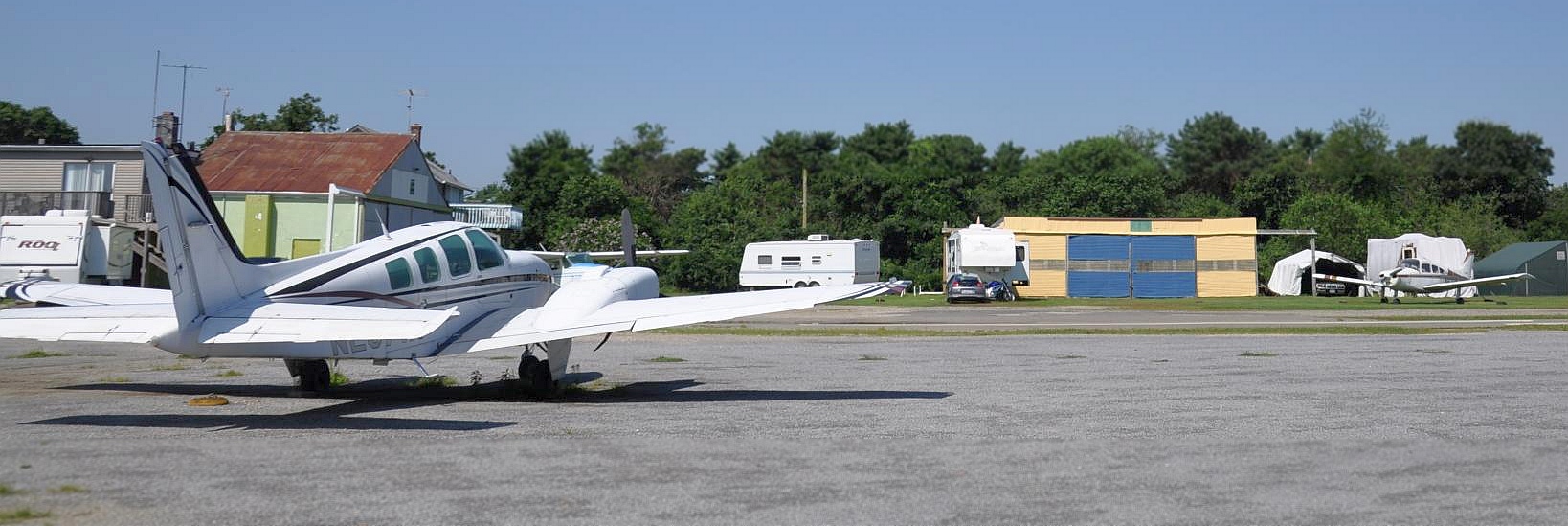
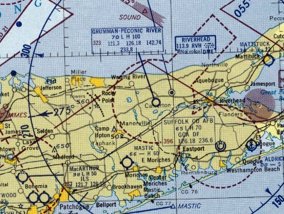
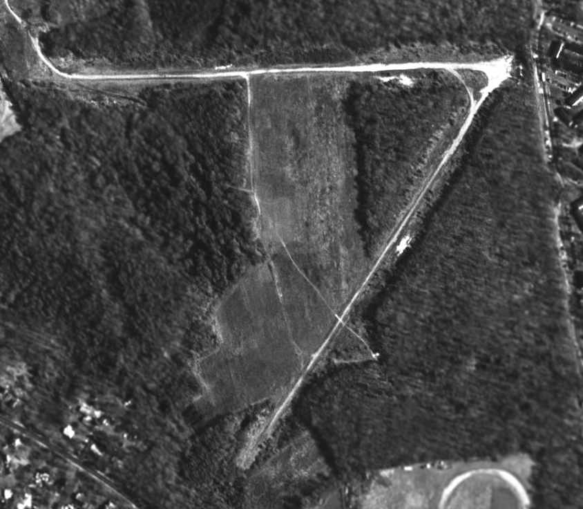
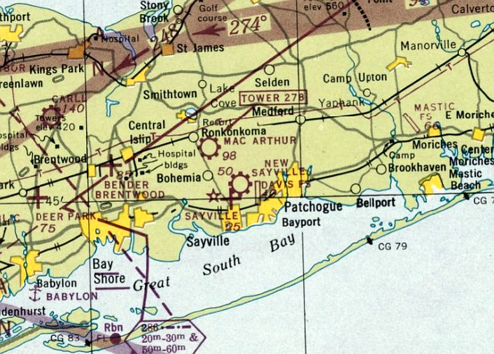
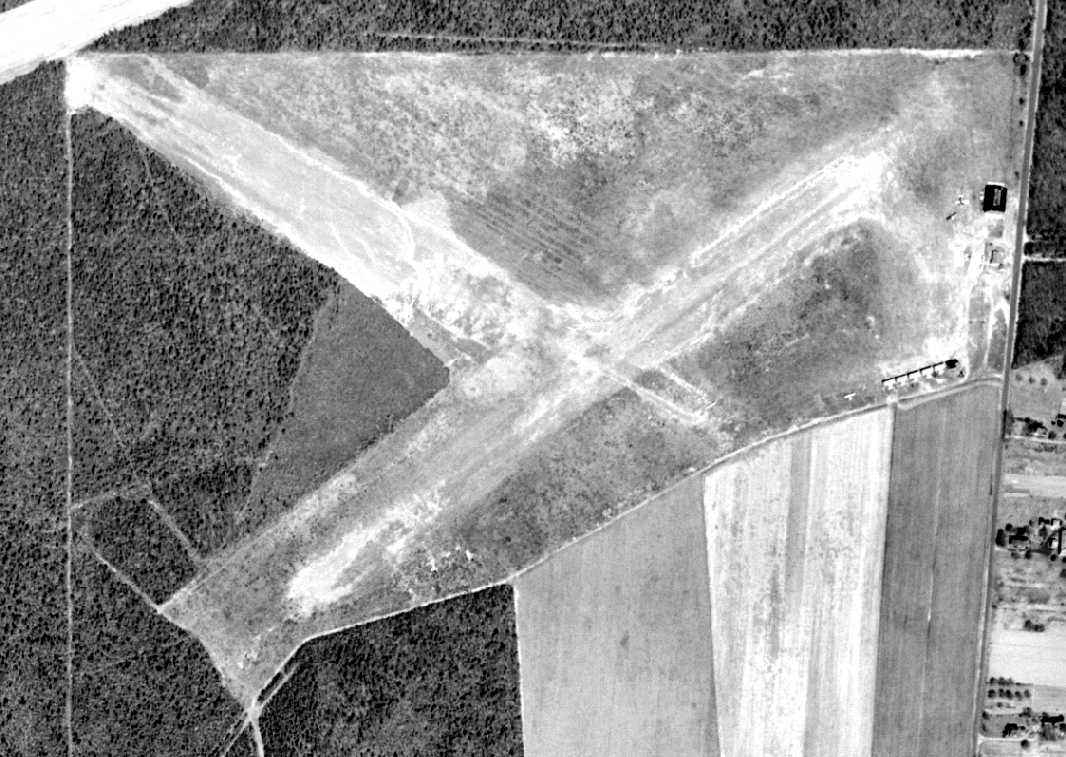
Lufker Airport (O00, 4NY7, 49N), East Moriches, NY
40.823, -72.75 (East of New York, NY)
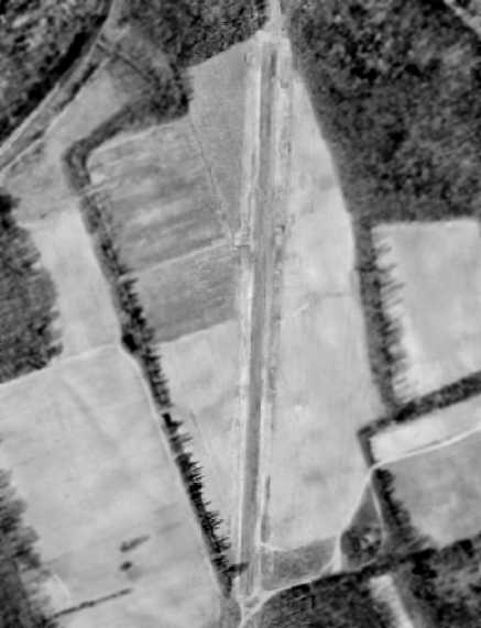
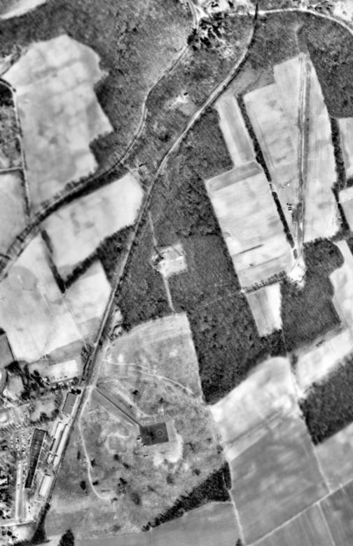
Lufker Airport, as depicted on a 11/11/59 USGS aerial view.
According to Wikipedia, “Lufker Airport was originally a farm field owned by Teddy Kijowski's father. After Teddy soloed his first airplane, he began taking airplanes into his father's field.
He used a dirt road that ran down the middle of the fields as his runway. The dirt road is where the current runway lays.
Eventually, Teddy bought his own airplane & began keeping it on the field. He also turned the dirt road into a grass runway. Friends began to bring their airplanes there & people started to rent tie-down spaces.”
The earliest depiction which has been located of Lufker Airport was on a 11/11/59 USGS aerial view.
It depicted a north/south grass clearing, but no planes or other aviation aspects were recognizable.
Strangely, Lufker Airport was not depicted on NY Sectional charts from the 1950s-80s.
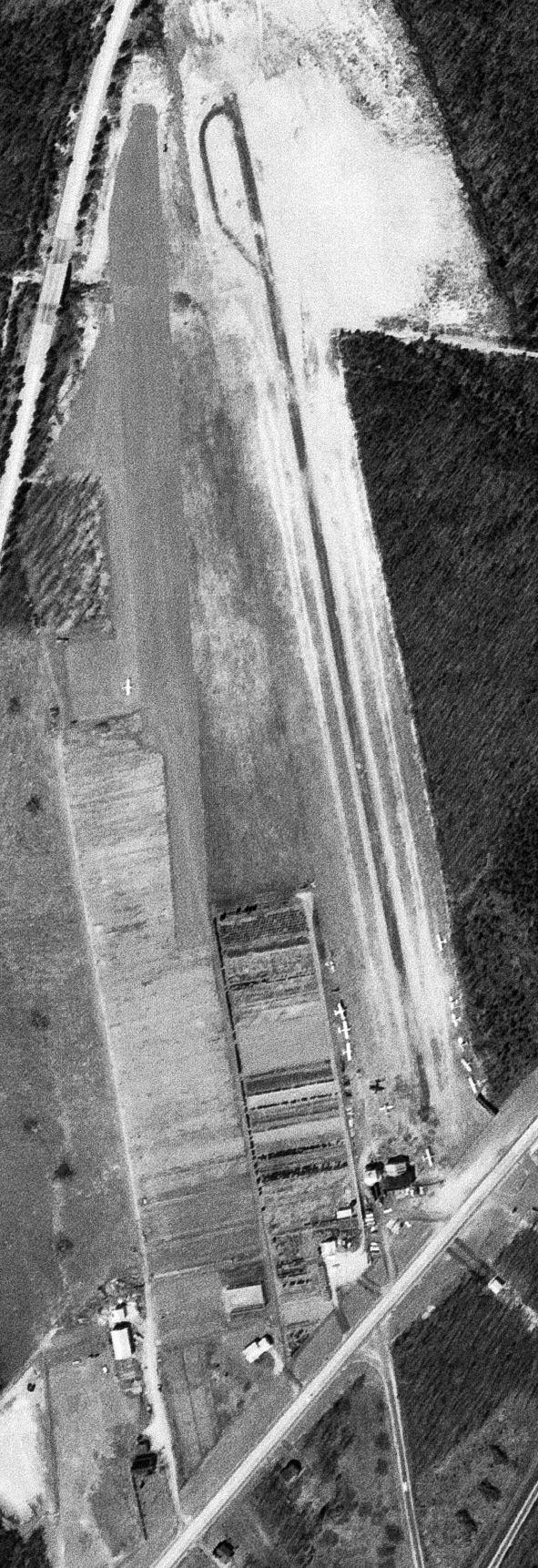
The earliest photo which has been located showing planes at Lufker Airport was a 3/29/66 USGS aerial view.
It depicted 1 light single-engine plane parked on the west side of a grass north/south runway.
Note that it also depicted the paved parallel runway of Spadaro Airport immediately adjacent to the east.
Wikipedia continued, “In the 1970s the airport was used for flight instruction & several airplanes were built from the ground up, including one built by Donald Trump's cousin Al Creighton.
In April 1984 Teddy Kijowski sold the airfield to Louis Lufker, a Suffolk County police officer who was interested in the field for several years.
Lufker was operating an aerial advertising business around the New York City area & was looking for his own field.
Lou was familiar with the field, many years prior he gave flight instruction (out of Zahn's & Bayport Airports) and brought his students in there.
Lufker was also operating seaplanes (charter) around the Long Island area around the same time.
As an Army Reserve Aviator, Lou brought Army helicopters into Teddy's Field & gave Mr. Kijowski rides. A friendship started which eventually led to Teddy selling the field to Lufker.”
Wikipedia continued, “The field has also been used by Hollywood actor Cliff Robertson. He flew into the field in the 1970s & hung around.
John F. Kennedy Jr. flew in & parked his airplane to go out to the Hamptons.
Lufker owns a Marine Corps L-19 that President John F. Kennedy bought & put on his compound so John Jr. could play in as a kid.
New York State Governor George Pataki used the field in the state helicopter.”
Wikipedia continued, “Since 1984, Lufker rented the field to several banner towing operations & at one time operated a glider school.
He also gave aerobatic flight lessons in his 1941 Stearman Biplane. Lufker is an Airfame & Powerplant mechanic & maintains aircraft on the field.
In the early 1990s Lufker opened a machine shop at the field - Lufker Precision Manufacturing made precision metal & plastic gears for the aircraft, automotive, and medical industry.
The field is home to general aviation aircraft including antique biplanes, ultralights, powered parachutes, helicopters, and gliders.
There is also a skydiving operation and a non-profit airplane museum called 'The Pioneers of Flight'. During the summer, there is a flea market on the airport grounds.
The Experimental Aircraft Association has a chapter on the field. In the past years, the field has hosted carnivals & a circus during the summer.”

The earliest aeronautical chart depiction which has been located of Lufker Airport was on the 1993 NY Sectional Chart.
It depicted Lufker as a public-use airport having a 2,300' unpaved runway.

A 1994 USGS aerial view looking northeast showed Lufker Airport to have a single grass north/south runway, with 2 light single-engine aircraft & a small hangar on the southeast side.
According to the FAA Airport/Facility Directory, for the year ending 9/8/10, Lufker Airport conducted an average of 7 takeoffs or landings / day.
It had 43 based aircraft: 25 single-engine, 15 ultralights, and 3 gliders.

A 2013 photo of a Citabria at Lufker Airport.

A 2015 photo of the Lufker Airport sign.
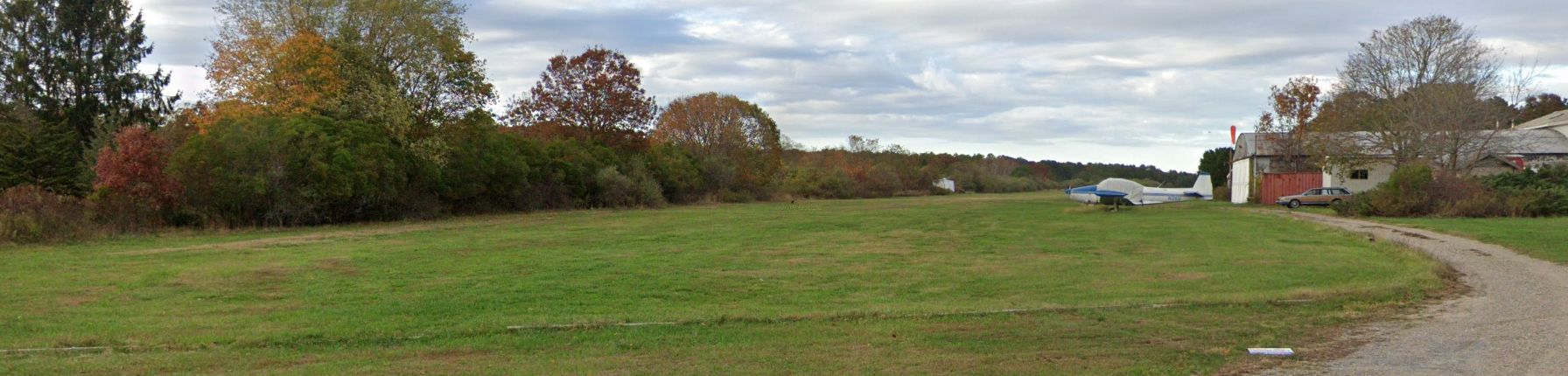
A 2019 photo looking north along Lufker Airport's runway showed a Navion parked next to the hangar.
The 2019 NY Terminal Aeronautical Chart depicted Lufker Airport as having a 2,300' unpaved runway & to conduct glider operations.

The last photo which has been located showing planes at Lufker Airport was a 2023 aerial view looking northeast, which showed 2 light single-engine planes parked on its east side.
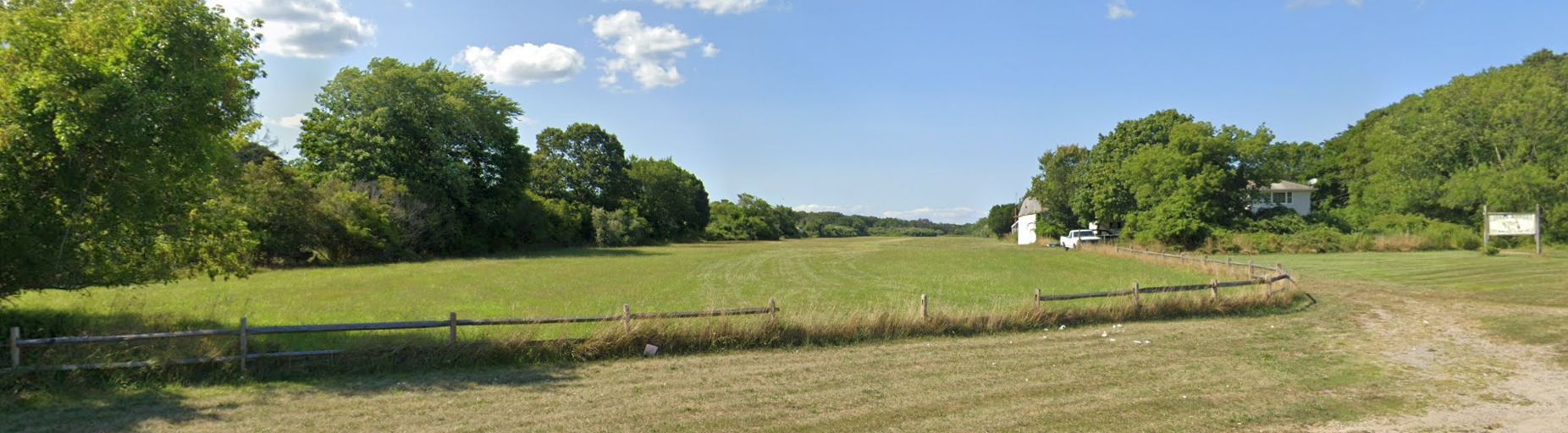
A 2024 photo looking north along Lufker Airport's runway showed the field devoid of planes.

The 2024 NY Terminal Aeronautical Chart depicted Lufker Airport as having a 2,300' unpaved runway & to conduct glider operations.
Ed Drury reported in 2024, the family which owns Lufker Airport “are closing it for development soon.”
Thanks to Ed Drury for pointing out the closure of this airport.
____________________________________________________
Flowerfield Airfield, Flowerfield, NY
40.9, -73.14 (East of New York, NY)
A 1954 aerial photo depicted the single north/south runway at Flowerfield.
This little airfield was the home of a pioneering but little-known company in the history of aviation - the Gyrodyne Company of America,
which developed the first practical unmanned helicopter.
It is ironic that in the beginning of the 21st century,
the development of armed unmanned aerial vehicles seems to be "all the rage" in the American aircraft industry,
yet this obscure little company was mass-producing an armed unmanned helicopter
(that even operated from the decks of small ships) way back in the 1960s.
The founder of Gyrodyne, Peter Papadakos, was the pioneer who perfected the American Coaxial helicopter design.
While other helicopter pioneers such as Igor Sikorsky pursued the tail rotor system,
Frank Piasecki the tandem rotor system & Charlie Kaman, the intermeshing rotor system,
Papadakos believed that the coaxial rotor system held the greatest promise.
Papadakos spent his entire life working tirelessly promoting his ideal of the "perfect helicopter".
Papadakos bought the assets of the bankrupt Bendix Helicopter company in 1946
(which included the unfinished design of a coaxial helicopter), and founded the Gyrodyne Company of America.
A small hangar facility was leased at Fitzmaurice Field at Massapequa, NY,
and it was there that the Gyrodyne Model 2B compound helicopter was developed
and eventually performed demonstrated flights for 7 Air Force pilots.
No airfield was yet depicted at this location on the 1947 USGS topo map.
By 7/1/51 enough capital has been raised to acquire a tract of land for the new company in St. James.
Originally called "Flowerfield", the property had been a flower nursery, run by a retired General Motors executive's wife.
On the 320 acres that Papadakos acquired for the company, several buildings & 2 homes stood.
The bulb storage facility (eventually called Building 1) totaled some 28,000 sq.ft.,
which was transformed into executive offices, engineering, drafting & machine shop facilities.
In 1951, Gyrodyne moved to this new location
which provided the company with both a permanent home & a base for future expansion.
From this new base of operations, the young Gyrodyne company
began to perform subcontract work for Long Island's strong defense base.
Such nearby aircraft companies as Republic & Grumman were customers for Gyrodyne's machine shop
and allowed for new tools & machines to be acquired
and underwrite the expenses associated with the helicopter development.
Most of the 50 or so part-time employees working for this small start-up were paid in Gyrodyne stock.
A machinist made $5 / hour, which translated to 1 share of common stock / hour.
Papadakos felt that making his employees shareholders of the firm
was his best chance of holding onto his quality machinists & engineers which were in high demand at the time.
In 1951, Papadakos sought a better way to control the Model 2B compound helicopter.
He knew he had to modify the airframe, but did not want to take his only flying aircraft apart.
One evening, a group of engineers gathered at the company's new facilities at Flowerfield.
The engineers saw what they needed to do - they literally cut the Model 2B in half in order to widen it & also lengthen the cabin;
all without Mr. Papadakos' knowledge.
Needless to say, many stressful days soon followed!
His Gyrodyne crew soon modified the model 2B by also removing the 2 side engines.
Also added were movable tail surfaces, power boost controls & other minor improvements.
In June 1951, Gyrodyne received it's first contract from the Naval Bureau of Aeronautics,
to accumulate & submit flight test data pertaining to the coaxial configuration.
The scope of the contract was to record the flying qualities of the coaxial configuration.
The resultant Model 2C was instrumented for the flight test program.
The instrumentation package included an oscillograph & a photo panel.
The flight test program was completed & final report submitted by December 1952.
This was the first documentation of flying qualities of a coaxial rotor helicopter in the US.
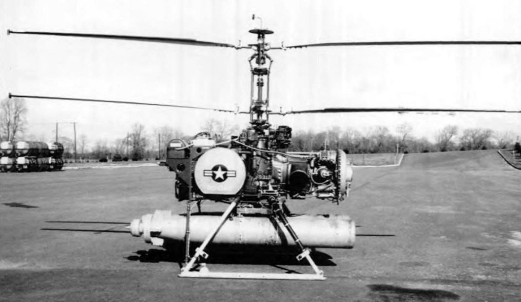
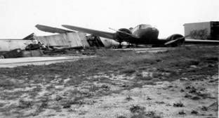
An undated photo of the sole Gyrodyne GCA2 (N74101), a 5 passenger compound helicopter which first flew in 1951.
Movable vertical surfaces (rudders) & differential collective in the rotors were incorporated for yaw of the flight test.
The results of the instrumented flight test indicated that the coaxial rotor configuration
possessed excellent flying qualities in all regimes of flight except for the low speed autorotation
where the yaw control means proved inadequate.
In order to overcome this difficulty, Gyrodyne continued its research work toward improving the directional control characteristics.
In March of 1953, the idea of using tip brakes on the tips of the rotor blades was conceived.
Flight tests of this concept proved that the problem of effective yaw control in autorotation for a coaxial helicopter had been solved.
This was a major breakthrough for the coaxial configuration, and the company was granted a patent for this configuration.
The tip brake "made the coaxial possible", Mr. Papadakos was to later state.
If fact, shortly after the development of that tip brake design,
the XRON Rotorcycle contract was awarded & Gyrodyne was on its way to becoming a major defense contractor.
The desired configuration of the XRON was changed to that of an unmanned drone helicopter,
thus creating the QH-50A (later known as the DASH).
No airfield at this location was depicted on the 1953 NY Terminal Aeronautical Chart (courtesy of Tim Zukas) or subsequent aeronautical charts.
The earliest depiction of the Flowerfield Airfield which has been located was a 1954 aerial photo.
It depicted the single north/south runway, which appeared to be the only aviation facility at the site at that time.
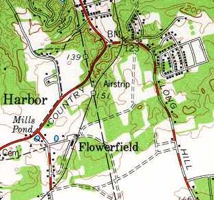
The Flowerfield Airfield was depicted (but labeled only as "Airstrip") on the 1956 USGS topo map.
It depicted Flowerfield as having a single 1,900' runway, oriented north/south.
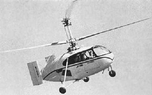
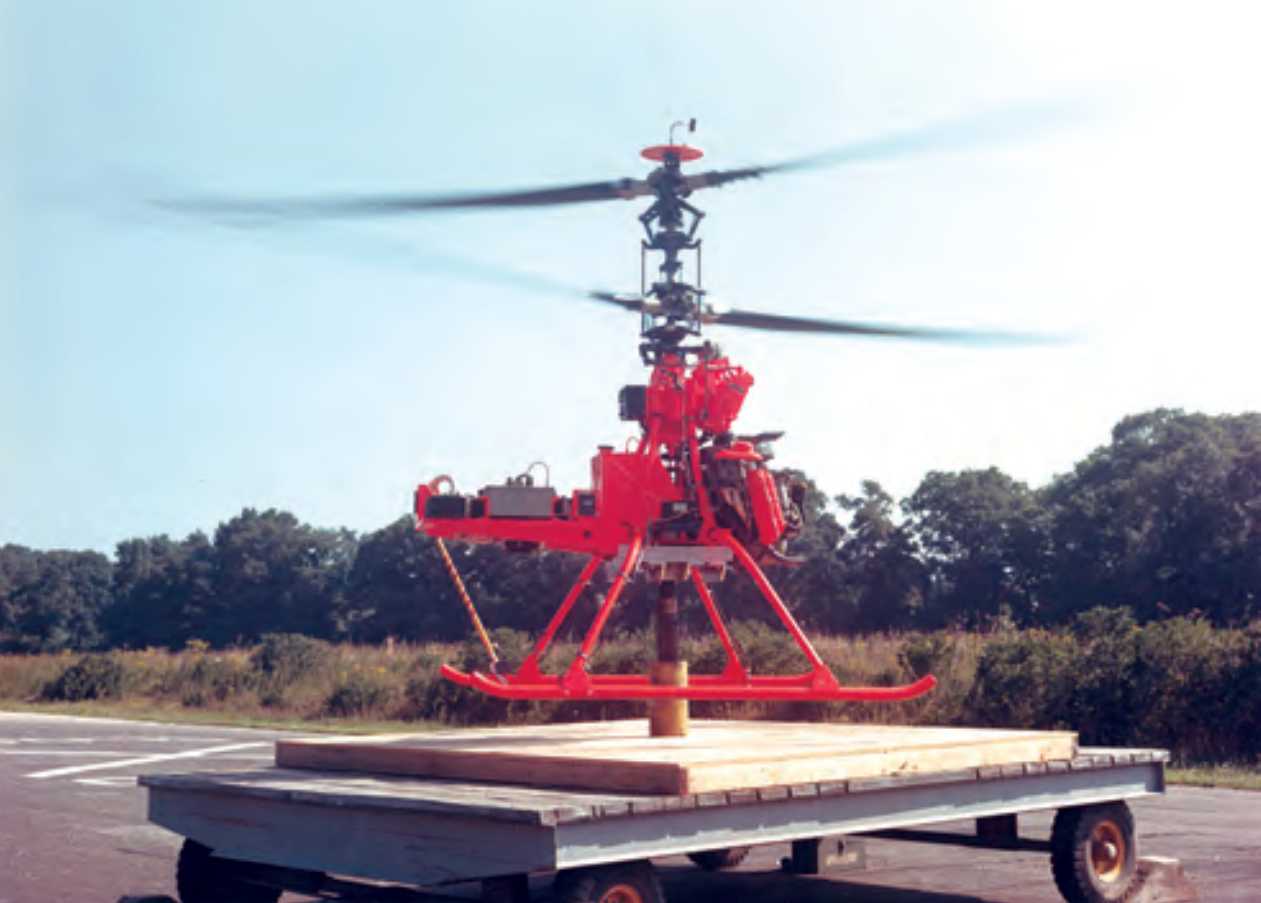
A 1960 photo of Gyrodyne's XRON 1-man reconnaissance helicopter flying over Flowerfield.
A 1961 aerial photo showed that a tethering rig had been added at some point between 1954-61 just southwest of the runway.
A 1962 aerial photo showed Flowerfield's north/south runway, tethering pad to the southwest,
and the Gyrodyne company plant buildings at the southwest corner.
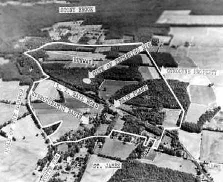
A circa 1960s aerial view looking northeast at the Flowerfield Airfield of the Gyrodyne Company (courtesy of Jos Heyman).
It depicted the single runway, as well as a circular "tethering rig" to the southwest of the runway,
and a "hydrodynamic basin" on the opposite (western) side of the railroad, across from the manufacturing plant.
By 1963, Gyrodyne had over 700 employees & many stationed all around the world to support the U.S. Navy's DASH weapon system.
However, Mr. Papadakos, still maintained the position as "head of marketing"
as he personally would invite dignitaries to his large Gyrodyne establishment
and speak with them of his company's coaxial helicopters & their benefits.
When it appeared that the modified XRON drone would actually become the initial DASH prototype,
major visits by the head Navy personnel increased dramatically by 1961.
A 1965 photo of a DSN-1 (QH-50A) on a Gyrodyne Flowerfield hover fixture.
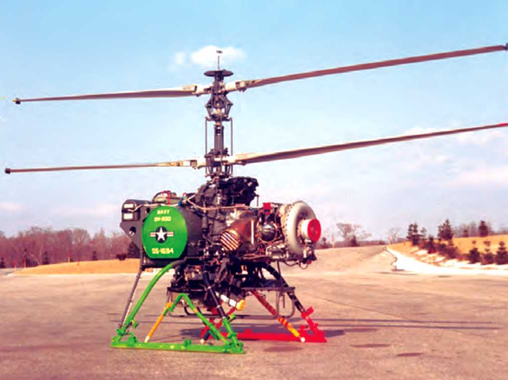
A circa 1960s photo of DS-1694, a QH-50D with the Snoopy sensor package, at Gyrodyne Flowerfield before it was deployed to Vietnam.
The QH-50 DASH drone helicopter which was eventually developed & mass-produced by Gyrodyne was a remarkable machine,
and an amazing engineering achievement for such a small independent company, particularly way back in the 1960s.
The QH-50 was powered by a single small turbine engine, which turned 2 contrarotating main rotor blades.
It was capable of operating off of the very small helicopter deck of Gearing-class destroyers, even in open sea conditions.
The mission of the DASH was to extend the anti-submarine 'reach' of its parent destroyer,
by delivering a payload of 2 homing torpedoes onto a submarine target detected by the destroyer.
With the development work & subsequent manufacturing of the QH-50A/B, QH-50C & the QH-50D,
Mr. Papadakos' life was centered on his evolving company.
It seemed that the greatest obstacle to his unmanned machine, that being Naval Aviators,
had accepted the idea that manned flight off destroyers was best left to expendable drones, but that was not to last.
While the QH-50C's enemy was that of the undersea "red menace"
in the manner of 300 Soviet fast-attack submarines & was a weapon system of deterrence,
the QH-50D found itself flying from fewer & fewer destroyers
as those DASH equipped ships began to reach their limit of their operational lifetime.
Yet DASH was not being installed on the new destroyers joining the Navy.
While the Navy's ship count was decreasing, the size of naval ships was increasing,
and the flight deck of new destroyers was being made larger
and designed around the new LAMPS (Light Airborne Multi-Mission-Purpose-Ship based) concept helicopters.
Suddenly, the Navy had more QH-50s than it needed, and by 8/29/69 the last Navy QH-50D had been delivered.
Although the Japanese DASH program had begun, it had not taken long to deliver their 20 D models
and parts demand for the meticulous Japanese mechanics was not as strong as it had been for the U.S. Navy.
One tech-rep for Gyrodyne had reported that Japanese QH-50s with over 1,000 landings
looked as if they had just come from the assembly line; they were so well maintained!
Mr. Papadakos had seen this end coming & had positioned the company to possibly having to survive with little or no government defense work.
On 6/14/66, he formed the Flowerfield Properties wholly-owned subsidiary of the Gyrodyne Company
for the purpose for holding certain assets of the company's property.
A circa 1968 photo of the world's first armed drone helicopter: a Gyrodyne QH-50 armed with 2 torpedoes, at the Flowerfield test site.
A 1969 aerial photo showed that another plant had been constructed to the southwest of the airfield
(on the east side of the road) at some point between 1961-69,
along with a large paved area that may have been related to flight tests.
During this time, however, Papadakos continued to try & convince the Department of Defense of the value of the coaxial rotor system.
In 1969, the Allison powered QH-50E had flown.
In 1970, the 2-stage transmission equipped 24' rotor system had successfully been flown.
That aircraft, with a slower rotor RPM of 570, allowed for greater speed & a payload of close to 2,000 pounds.
Then in 1971, Mr. Papadakos used the knowledge gained from the 2-stage transmission / 24' rotor system program
to enter the Heavy Lift Helicopter (HLH) competition.
Unfortunately, the government decided after asking for a request for proposal
from all the helicopter companies to cancel the program.
That was the final request for proposal Gyrodyne ever responded to.
Papadakos felt that to place his company at risk on the whimsical needs of the military no longer justified the risks.
He consolidated the remaining helicopters in part of Gyrodyne's building #17
so that what parts support & transmission overhauls required could occur.
By 1972 Papadakos was remodeling the now empty Gyrodyne Flowerfield manufacturing facilities
and subdividing them into small suites in order to turn the property into an industrial park.
In 1986, Papadakos was approached by both the Israeli Aircraft Industries & Dornier Gmbh of Germany
to examine the use of the QH-50E as a modern surveillance drone with modern electronics.
While the Israelis purchased a Technical Data Package containing engineering reports & flight analysis of the QH-50E,
Dornier took their interest much further. In the Summer of 1986, Dornier sent a 3 person team to learn all they could about the QH-50D.
After dismantling one aircraft for inspection & then reassembling it, Dornier flew the aircraft on a hovering fixture on 10/16/86.
This had been quite an effort for Mr. Papadakos, who at age 72, found himself working long hours as a Program manager yet again.
Papadakos also had found it difficult to find former employees
whom after 17 years since the assembly line had shut down, were physically able to do the work.
Luckily, several former employees were available to assist in the effort
which concluded when Dornier asked to take the aircraft back to Germany
to integrate their digital auto-pilot & other modifications for their GEAMOS program.
In the spring of 1987, Mr. Papadakos received visitors from the Naval Air Warfare Center, China Lake, CA.
The QH-50D was still in use by the Navy as a target for anti-helicopter missiles.
The Navy needed rotor blades for those aircraft & requested a bid to have blades made.
Papadakos put a bid on the cost of finding personnel from the production days when Gyrodyne made their own blades.
Also, the Navy wanted to take possession of the remaining helicopters they owned under a no-cost contract,
but which Gyrodyne had stored for the Navy for safe-keeping.
In the fall of 1987, those helicopter assets left with many of the Rotorcycles going to museums & schools (which wanted the Porsche engines for shop classes).
From 1988-91, Papadakos spent his time assisting Dornier with their drone development.
During this time, political upheaval had changed the mission of the Dornier/QH-50E
from that of a land based drone used for reconnaissance against East Germany
to that of being based on a destroyer to patrol the waters of a unified Germany;
like it had been during the DASH days.
To see the revitalization & interest of the very aircraft that had launched his company's future some 35 years before
was a huge source of pride for not only Mr. Papadakos, but the few still surviving original helicopter employees
that had been part of the largest Unmanned Aerial Vehicle program in the world.
Papadakos kept working on advancing his aircraft's role in the world until he died on 5/26/92.
As seen in a 4/8/94 USGS aerial view looking northwest, the single north/south runway remained intact at Flowerfield (right side of photo).
The tethering pad (previously used for helicopter flight tests) is just to the west of the runway,
and the former Gyrodyne company plant buildings are at the southwest corner (bottom-left).
Mr. Papadakos' death left many tasks uncompleted.
By 1995, Gyrodyne was producing 60 plus rotor blades for the Navy - a contract worth over $ 1.4 million.
Dornier continued with their program & eventually received 3 aircraft & other parts
for their Allison engine powered SEAMOS maritime surveillance drone.
By 1998, Gyrodyne faced the hard economic realities of storing helicopter assets that had not generated any income since 1986
in which the personnel who had created those assets, had simply passed away.
Faced with not being able to service the now only user of the QH-50,
the Army's Program Executive Office, Simulation, Training & Instrumentation (PEO STRI),
Gyrodyne management made the decision to enter into an agreement on 10/29/99
with Aviodyne U.S.A. of Los Angeles, to take possession of all remaining QH-50 assets
to support the U.S. military users of the QH-50.
President Stephen Maroney reported that "This action is in keeping with our clear direction
to focus on the Company's primary asset - the 326 acre Flowerfield property."
By December 1999, all helicopter assets had been removed from Gyrodyne-New York,
and placed within the company in Los Angeles, called Gyrodyne-CA.
In combination with the disposal of its oil investments, the Company was expected to realize proceeds of approximately $400,000.
"While neither of these sales represent a major financial impact for the Company,
the Aviodyne agreement brings closure to a very significant part of Gyrodyne's history -
the design & manufacturing of helicopters for military use primarily during the 1950 & 1960s", Maroney said.
As of 2004, the Gyrodyne Company continues to operate,
but its primary focus has become the redevelopment of the Flowerfield property (a total of 314 acres).
Five former Gyrodyne buildings (Buildings 1, 2, 7, 8, and 17) have been leased to other tenants for light industrial uses.
A 4/4/04 aerial view depicted the Flowerfield runway in largely the same manner as seen in 1994.

into a private community with an 18-hole championship golf course & 336 luxury residential units.
Yet another airfield removed to make way for a golf course -
that seems to be a common fate for so many of our country's historic airfields.
A circa 2006 aerial view looking west at the former Flowerfield tethering pad (previously used for helicopter flight tests).
According to Keith, “The big building on the far side of the pic of the tethering pad was” dates from before 1973.
A circa 2006 aerial view looking west at the former Flowerfield runway.
According to Keith, this was added at some point after 1985.
A 11/25/06 aerial view showed that land adjacent to the east side of the former runway had been cleared for construction,
and much of the former runway pavement had faded (or been removed).
A 3/31/07 aerial view showed that construction had begun on a building on the east side of the former runway.
A 9/6/09 aerial view showed that an unknown building had been completed on the east side of the former runway,
and the alignment of the former runway was no longer recognizable,
erasing the last sign of this little former airfield which occupied an interesting place in American military aviation technological development.
A 2019 aerial view looking northwest showed no trace remaining of Flowerfield's former runway (right side of photo).
However the helicopter tethering pad remained (center of photo), along with the former Gyrodyne company plant buildings at the southwest corner (bottom-left).
Evidently the 2004 plan for developing a golf course housing community on the site never came to fruition.
The site of Flowerfield is located northwest of the intersection of Mills Pond Road & Parkside Avenue.
Thanks to Jos Heyman for pointing out this airfield.
____________________________________________________
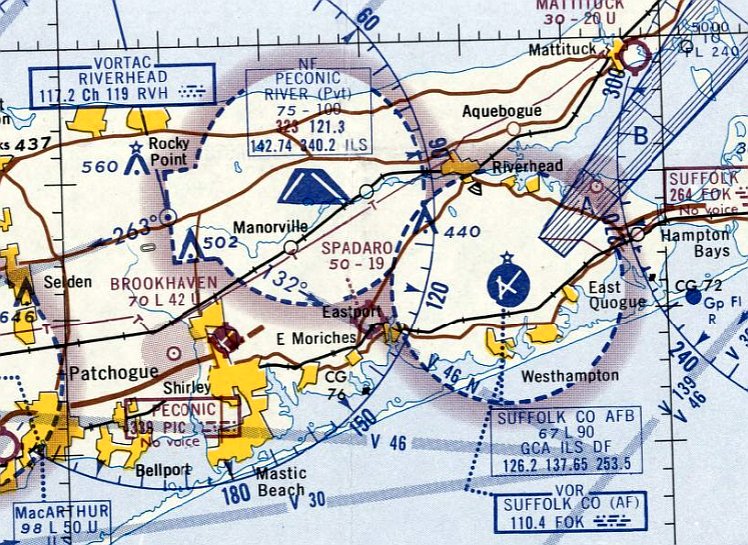
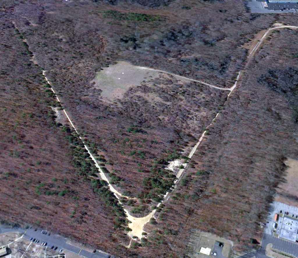
Spadaro Airport (1N2), East Moriches, NY
40.828, -72.749 (East of New York, NY)
Spadaro Airport, as depicted on the April 1965 NY Sectional Chart.
Spadaro Airport was not yet depicted on a 1961 aerial photo.
According to its FAA Airport/Facility Directory data, Spadaro Airport was activated in June 1962.
According to Jeff Sellars, “Bart Spadaro was the founder of this airport in the 1950s.
Spadaro used to run all of the services out of this little 2,000' airstrip.
Bart was an instructor pilot & had a full small flight school there; he was also an A&P & IA aircraft mechanic.”
The earliest depiction which has been located of Spadaro Airport was on the April 1965 NY Sectional Chart.
It depicted Spadaro Airport as having a 1,900' unpaved runway.
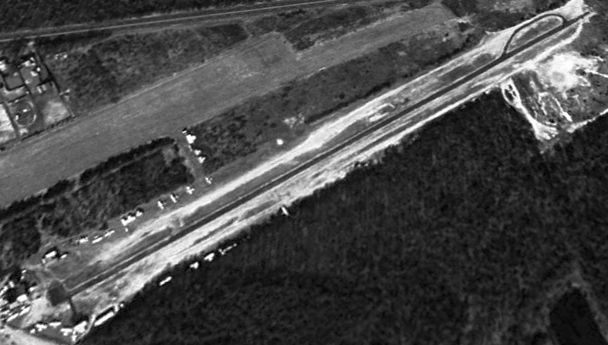
The earliest photo which has been located of Spadaro Airport was a 3/29/66 USGS aerial view.
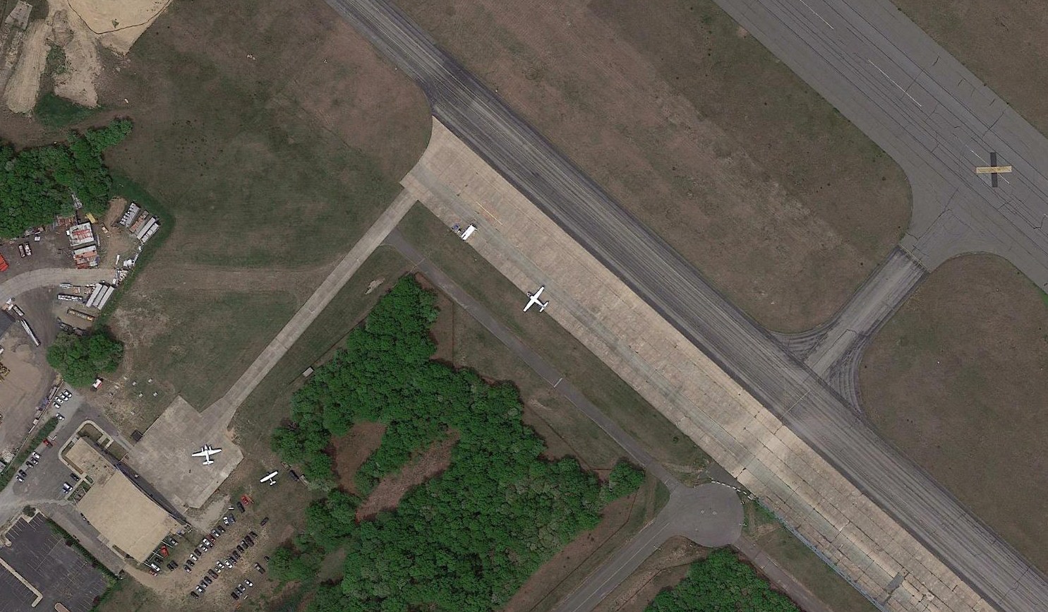
It depicted a paved northwest/southeast runway, with 10 light single-engine aircraft parked near a few small buildings on the south side.
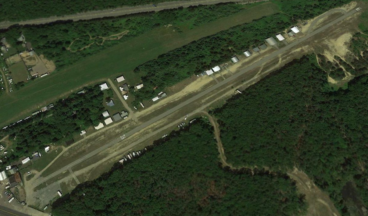
Note that it also depicted the unpaved parallel runway of Lufker Airport adjacent to the west.
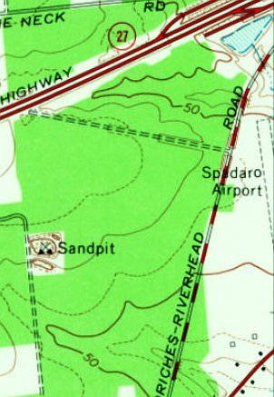
The earliest topo map depiction which has been located of Spadaro Airport was on the 1967 USGS topo map.
It depicted Spadaro Airport as having a single unpaved north/south runway.
A 1994 USGS aerial view looking northwest showed that Spadaro Airport had an asphalt north/south runway & a dozen light aircraft & several small buildings along its south side.
An 8/1/09 photo of a Beech Baron at Spadaro Airport.
According to the FAA Airport/Facility Directory, for the year ending 9/8/10, Spadaro Airport conducted an average of 16 takeoffs or landings / day.
It had 29 based aircraft: 15 ultralights, 12 single-engine, 1 multi-engine, and 1 helicopter.
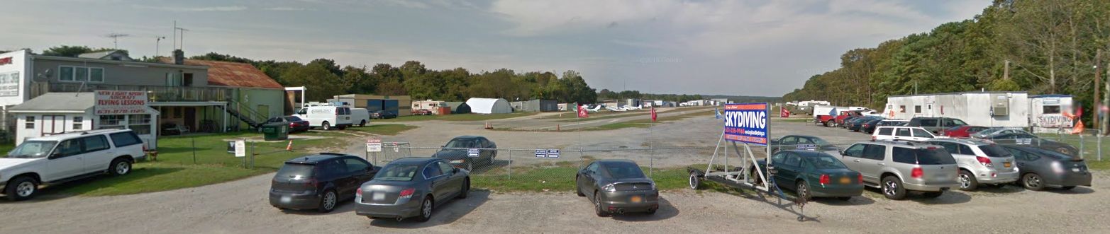
A 2012 photo looking northwest at Spadaro Airport, showing signs for flying lessons & skydiving.
Jeff Sellars reported, “Around here, Long Island, where the prices went skyrocketing up through the roof,
it has become very hard for an average guy to get into or stay into general aviation anymore.
It has become something that is reserved for the wealthy. Or successful business owners.
Renting a hanger spot for one plane at nearby Farmingdale is between $1,000-$1,500.
At Spadaros, Bart was charging us $50/month until 6 years ago & it went up to $100/month,
then when he passed [in 2013] his daughter was asking for an increase to $200/month & most of us struggle with that.
The owner is the lady Mrs. Spadaros. She inherited the property a few years ago when her father, Bart Spadaro passed away [in 2013].”
According to Wikipedia, “Bart Spadaro (founder of the airport) died 10/5,/13, at which time Susan Spadaro (Bart's daughter) assumed control of the airport.
Since then, aviation services such as aircraft maintenance, aircraft repair, aircraft inspections, aircraft rentals, flight instruction, sightseeing, etc. were no longer available at the facility.
Skydiving operations continued at the airport & were provided by an independent operator.
Airport maintenance was the removal of debris around the perimeter of the airport as well as removal of abandoned vehicles & hangars. The dirt taxiway was not very well maintained.
The segmented circle was typically overgrown with weeds & was not visible during warmer months. There were no wind sock, flags or any other devices on the field to indicate wind direction or wind speed.
The asphalt runway surface was in generally good condition although there was a pothole near the beginning of Runway 18 on the right side. Markings for Runway 18 were faded to the point of no longer being visible.
Adjacent to the runway was mostly bare sandy ground that was prone to creating dust clouds & flung gravel in the presence of propeller blast.
Susan Spadaro was not known to hold any credentials in the field of aviation.
As of 2016, the airport was closed to operations. The town of Brookhaven decided to shut down the airport, due to failure of pilots to action the noise abatement procedures established by the town,
bringing a series of complaints that led to its closure, as well as the closure of Lufker Airport for 3 months.
In 2018, the airport & the land were listed for sale at $2,900,000.”
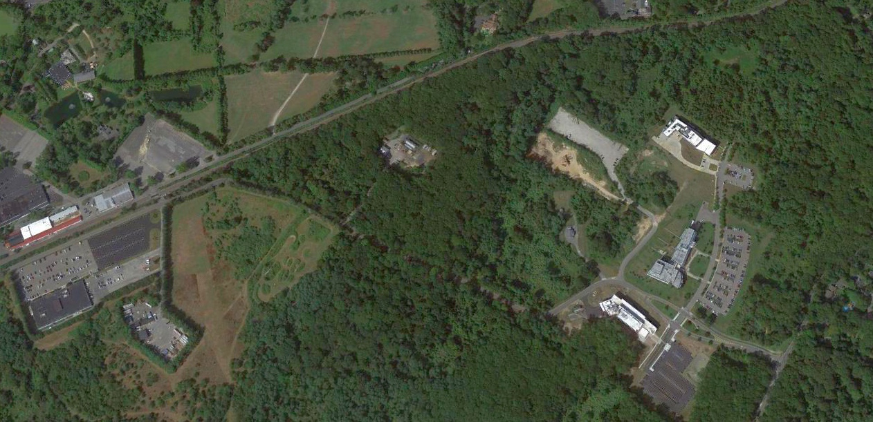
A 2018 aerial view looking northwest showed that Spadaro Airport's Runway 18/36 & numerous hangars remained intact, but with only 1 single-engine aircraft remaining visible on the field.
More aircraft were visible along the adjacent grass runway of still-open Lufker Airport in the background.
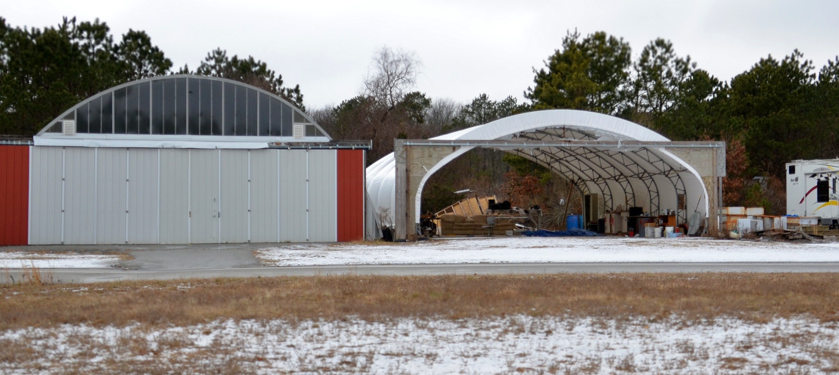
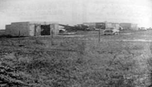
A 1/1/18 photo of Spadaro Airport hangars.
The 2019 NY Terminal Aeronautical Chart depicted Spadaro Airport as having a 2,400' paved runway north/south runway, and to conduct parachute operations.
As of 2019, the FAA Airport/Facility Directory described Spadaro Airport as having a 2,400' asphalt Runway 18/36 “in good condition”.
It was said to be owned by Bart Spadaro, and managed by Susan Spadaro.
Sparado Airport was said to have 26 based aircraft, and to conduct an average of 17 takeoffs or landings per day.
Jeff reported in 2019, “Adjoined, the property next door with this airport is another airport which is a grass runway & that is called Luftger & it is a different owner.
Some of us were using Lyft car by taxiing over to the other field but he decided to close off the opening so now Spadaros Airport is just for storage of RVs & boats.
There were two sky diving operations running out of these airports.
One company at each airfield. They have been there for years, Long Island Skydiving & the other one I think was Sky Dive Long Island.”
Jeff continued, “The closures started with noise complaints coming from some new high-end neighborhood, near the fields.
They went to the town & the town opened the books & found something off with the paperwork regarding zoning, business permits, etc.
They closed Luftger first then a few weeks later Spadaros. But Luftger got a lawyer & fought & 2 years later it reopened.
But Susan Spadaro did not fare well in the battle as she did not have finances for representation.
It’s sad in many ways - it closes out an era for us pilots there.
Some guys have been there for 40 years & they had to sell their planes & get out of aviation.
I am an average guy, carpenter, home improvement, etc., I struggle to stay in it. But I love it.
I still have my hangar on the field & I am one of the last few guys still there but no one flies out of the field anymore.”
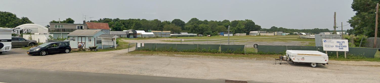
A 2021 photo looking northwest at Spadaro Airport, showing the hangars & runway.
Spadaro Airport is located northeast of the intersection of Montauk Highway & Locust Avenue.
Thanks to Jeff Sellars for pointing out this airport.
____________________________________________________
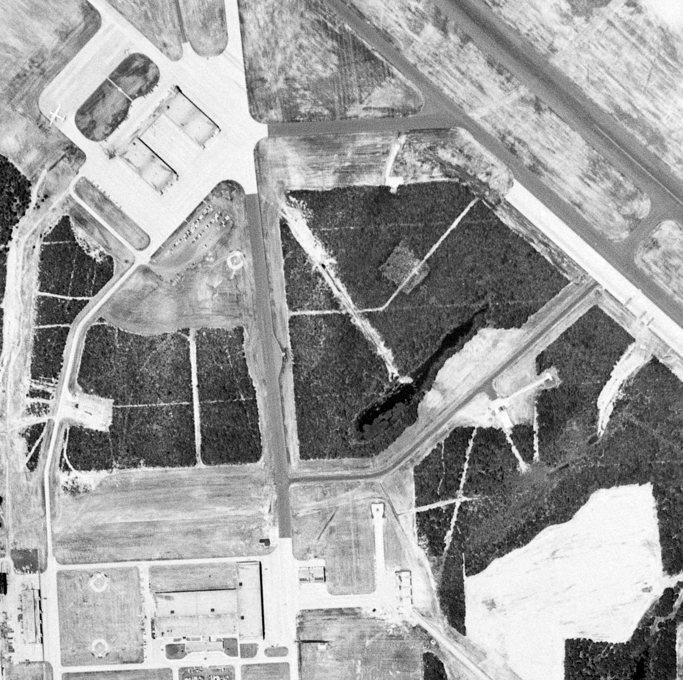
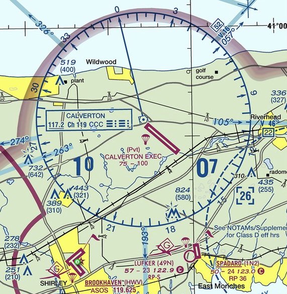
Grumman Peconic River Airfield / Calverton Executive Airpark (CTO), Calverton, NY
40.92, -72.79 (East of Bethpage, NY)
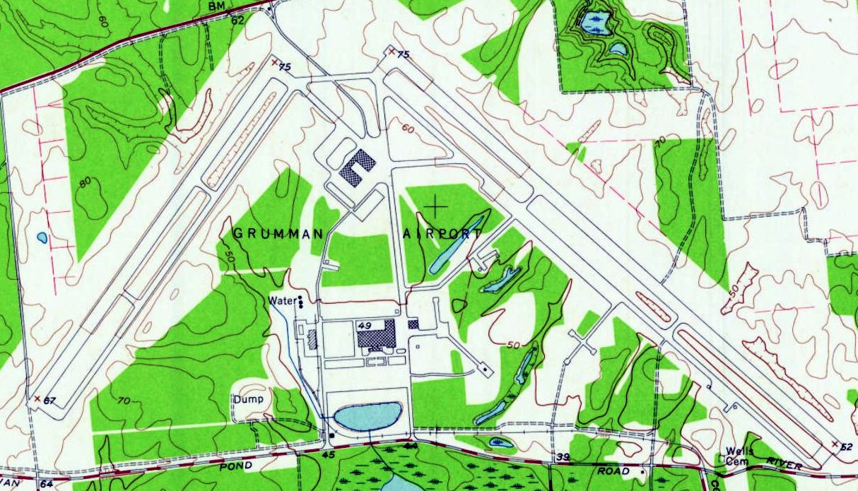
“Grumman Peconic River" Airfield, as depicted on the July 1954 NY Sectional Chart.
Peconic River Airfield was built as the factory airfield for Grumman's Calverton factory.
Their was was designated the Naval Weapons Industrial Reserve Plant, Calverton (NWIRP),
a government-owned, contractor-operated (GOCO) facility.
According to Wikipedia, “About 1950, the United States Navy purchased about 6,000 acres on the Peconic River.
Among the properties purchased was a mansion belonging to the grandson of F.W. Woolworth.”
Peconic River's 2 paved runways (14/32 & 5/23) were completed in 1953.
Peconic River Airfield was not yet depicted on the January 1954 NY Sectional Chart.
The earliest depiction which has been located of the Peconic River Airfield was on the July 1954 NY Sectional Chart.
It depicted Grumman Peconic River Airfield as having a 10,000' paved runway & a control tower.
The Assembly Building (Plant 6) was accepted for Grumman operation in 1954, and production commenced that same year.
Also in 1954, Hangar #4 was occupied by the Flight Test Department, and Hangar #1 was occupied.
In 1956, construction was completed on the Firing-In area (gun butts) & the Engine Test House.
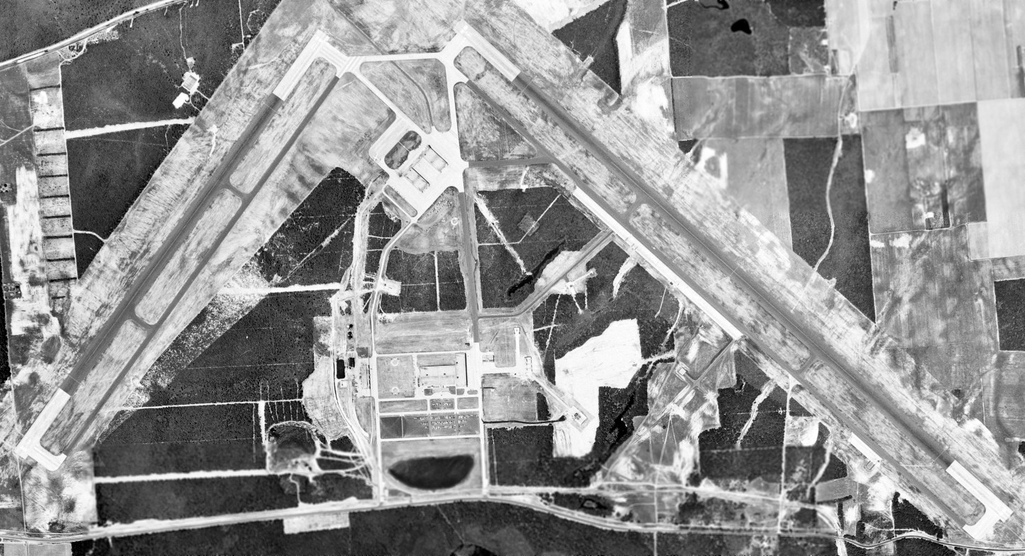
The earliest photo which has been located of the Peconic River Airfield was a 6/10/57 USGS aerial view.
It depicted the field as having 2 paved runways, taxiways, ramps, hangars, and factory buildings.
A closeup of the 6/10/57 USGS aerial view of the Peconic River Airfield showed a unidentified twin-engine aircraft on the northwest ramp.
The 1957 USGS topo map depicted “Grumman Airport” as having 2 paved runways, taxiways, ramps, hangars, and factory buildings.
The Rotodome Test Area (used for E-2 Hawkeye radar development) was completed in 1961.
The 1962 AOPA Airport Directory described Peconic River Airfield as having 2 paved runways.
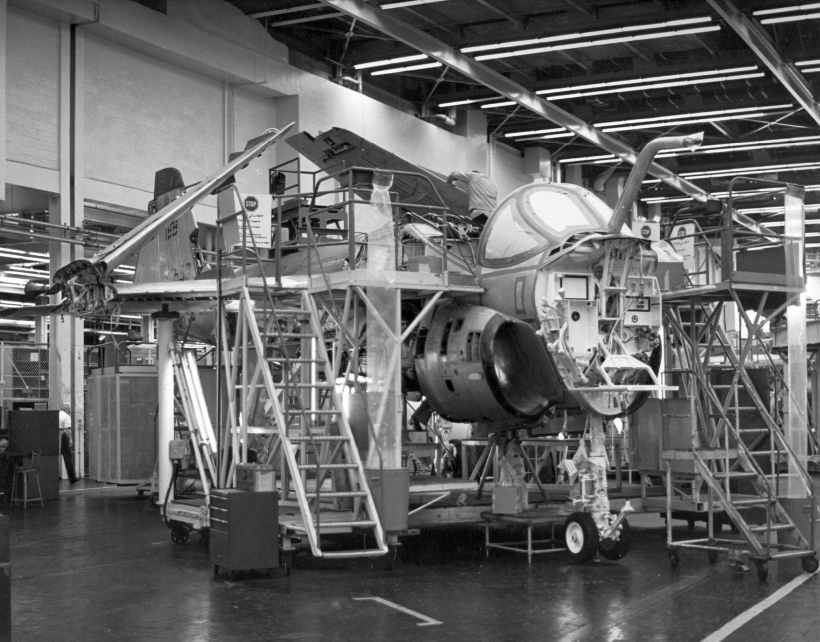
Grumman's Calverton facility eventually was the birthplace of many famous Grumman aircraft, including the F-14 Tomcat, A-6 Intruder, EA-6B Prowler, and E-2 Hawkeye.
The Grumman site consisted of Plant 6, where final assembly of F-14s, A-6s, EA-6Bs, and E-2Cs took place, and the Flight Test Plant 7.
In 1965, New York Governor Nelson Rockefeller proposed converting the Peconic River Airfield into the 4th New York City metropolitan airport joining Laguardia, JFK, and Newark Airport.
The proposal was abandoned following opposition from both Grumman & local residents.
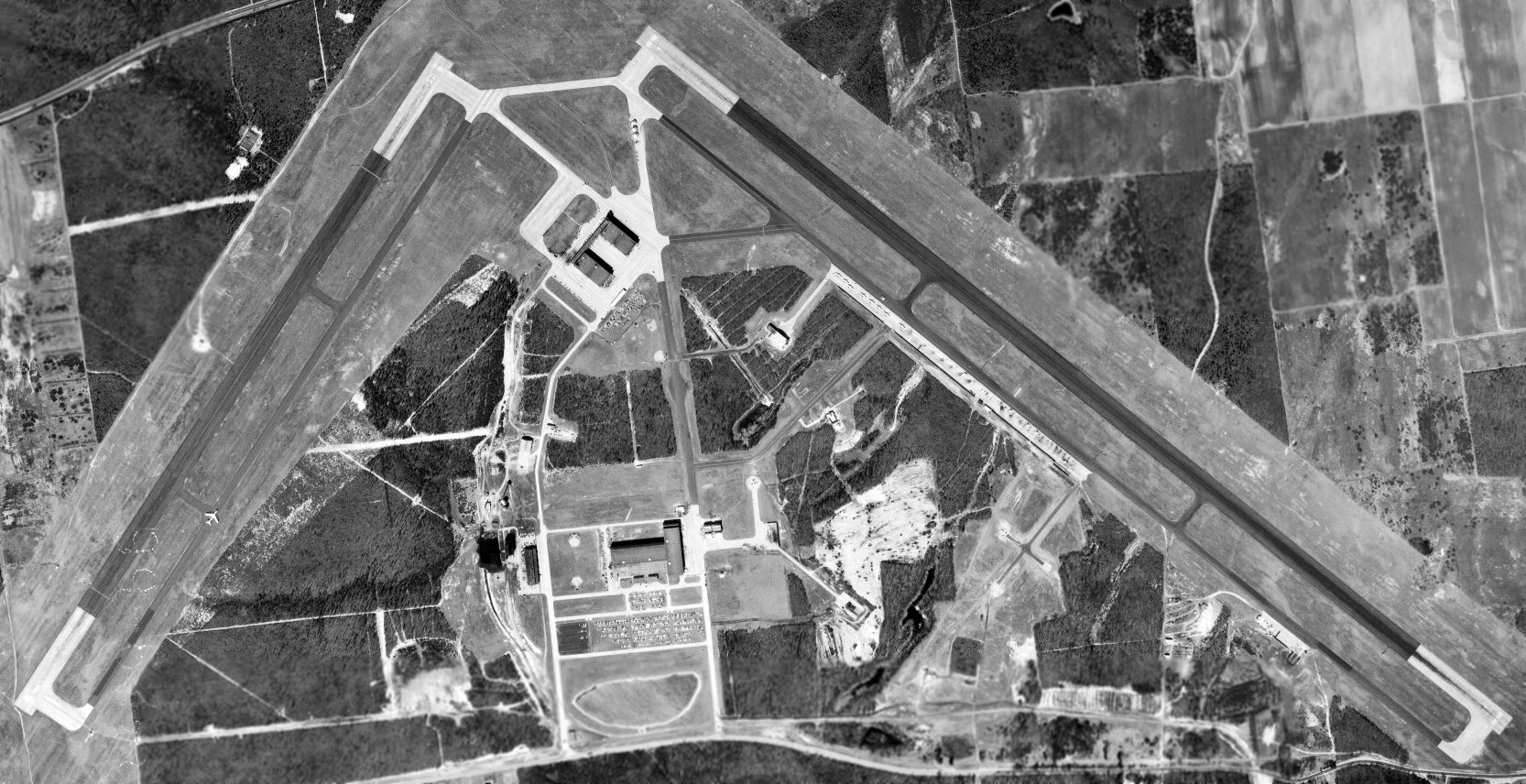
A 3/29/66 USGS aerial view depicted the Peconic River Airfield with the same runway configuration as seen in 1957.
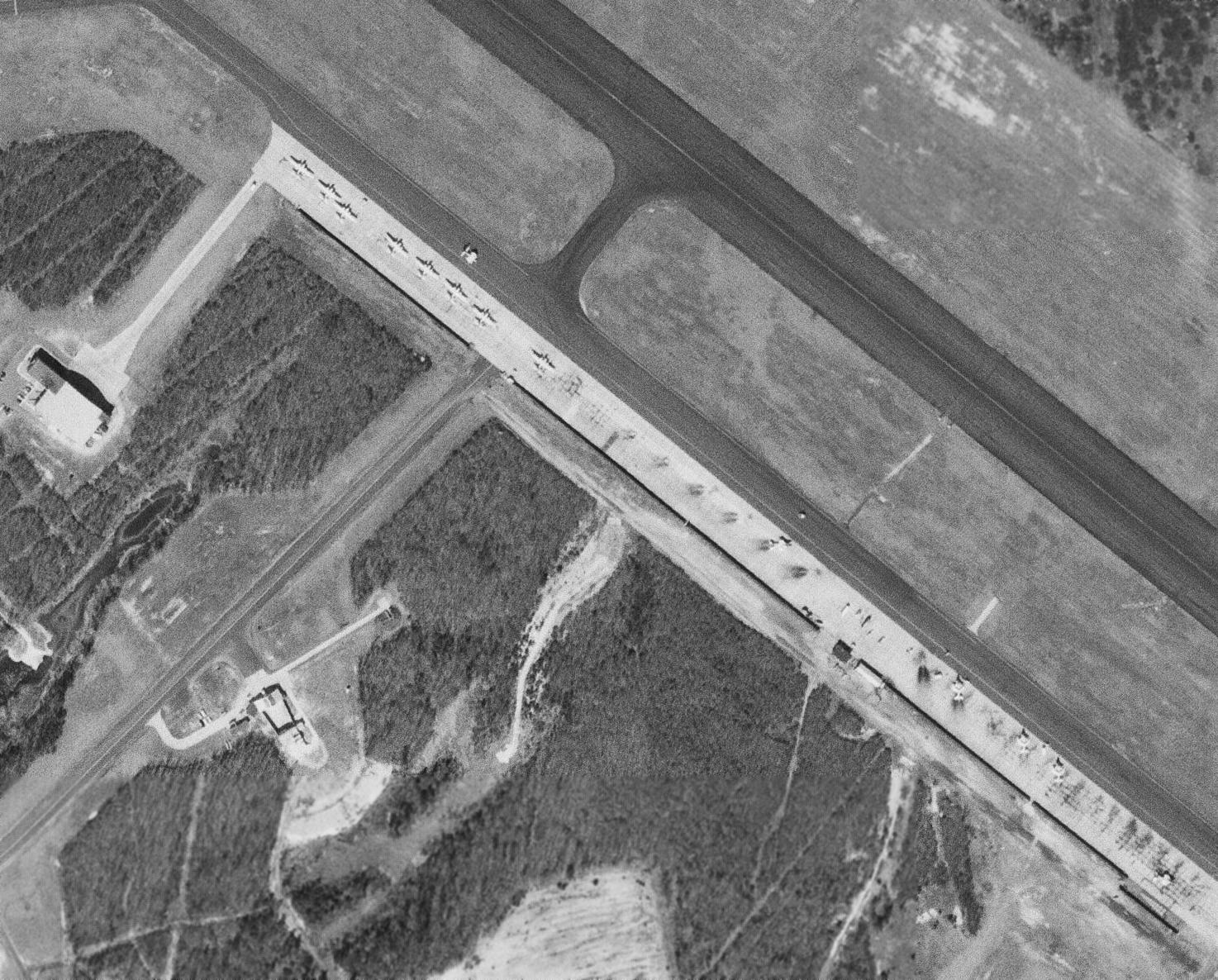
A closeup of the 3/29/66 USGS aerial view of the Peconic River Airfield showed 13 aircraft (S-2 Trackers & A-6 Intruders?) on the northeast ramp.
During the Space Race, Grumman built a mock-up of the lunar surface at Calverton to test its proposed Mobility Laboratory (MOLAB) vehicle,
and many of the lunar astronauts visited the plant.
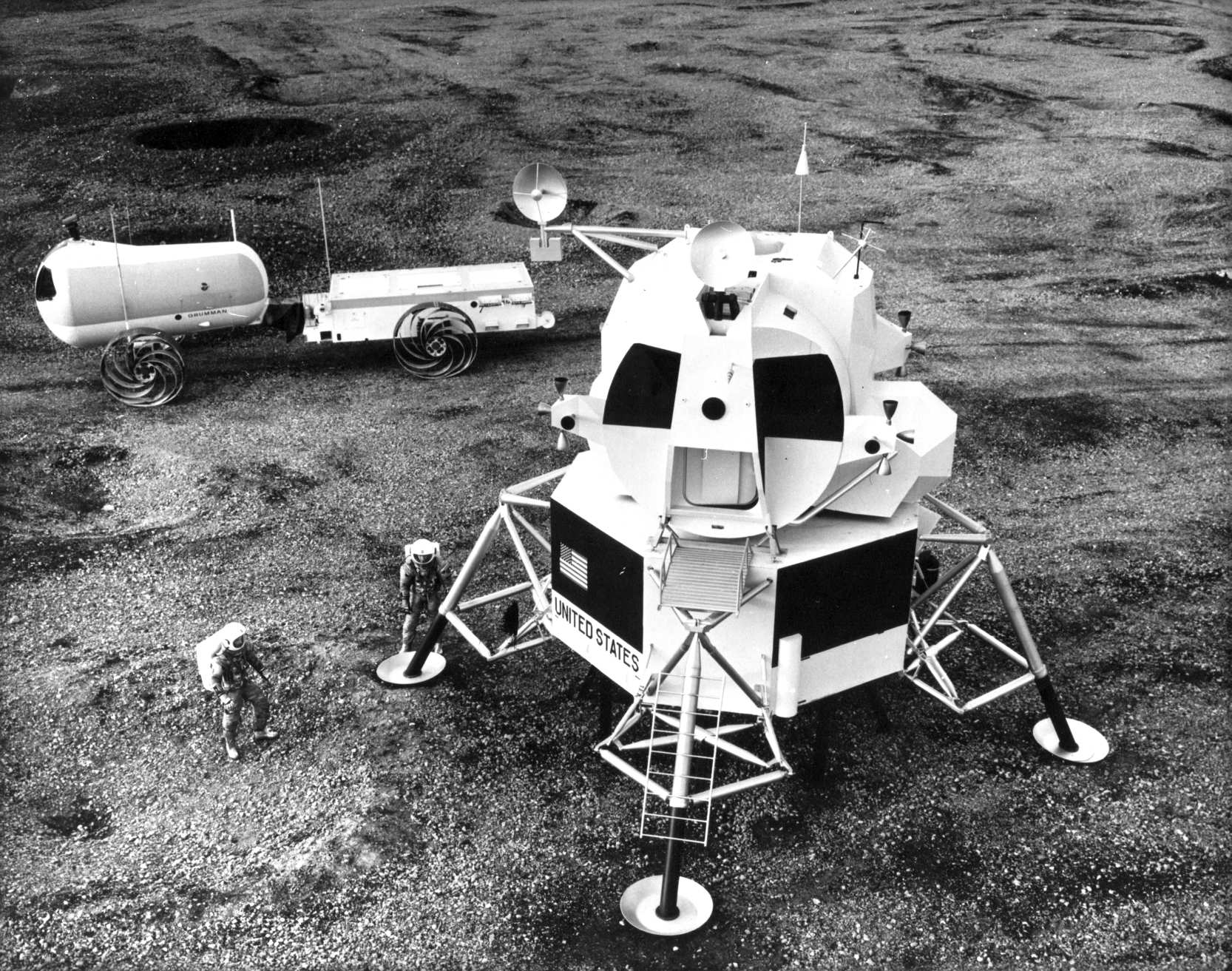
A circa 1969 photo of prototypes of the Grumman Mobility Laboratory (MOLAB) & Lunar Excursion Module on a simulated lunar surface at Grumman's Calverton plant at Calverton.

A 12/21/70 photo of the rollout of the first Grumman F-14 Tomcat fighter (BuNo 157980) at Grumman's Calverton plant.

A 1972 photo of a mockup built at Grumman's Calverton plant of a proposed F-14 Tomcat variant for the Air Force's Air Defense Command.
A 1973 or later photo of Grumman A-6A Intruder BuNo 155632 on the Grumman Calverton assembly line during its upgrade to the A-6E configuration.
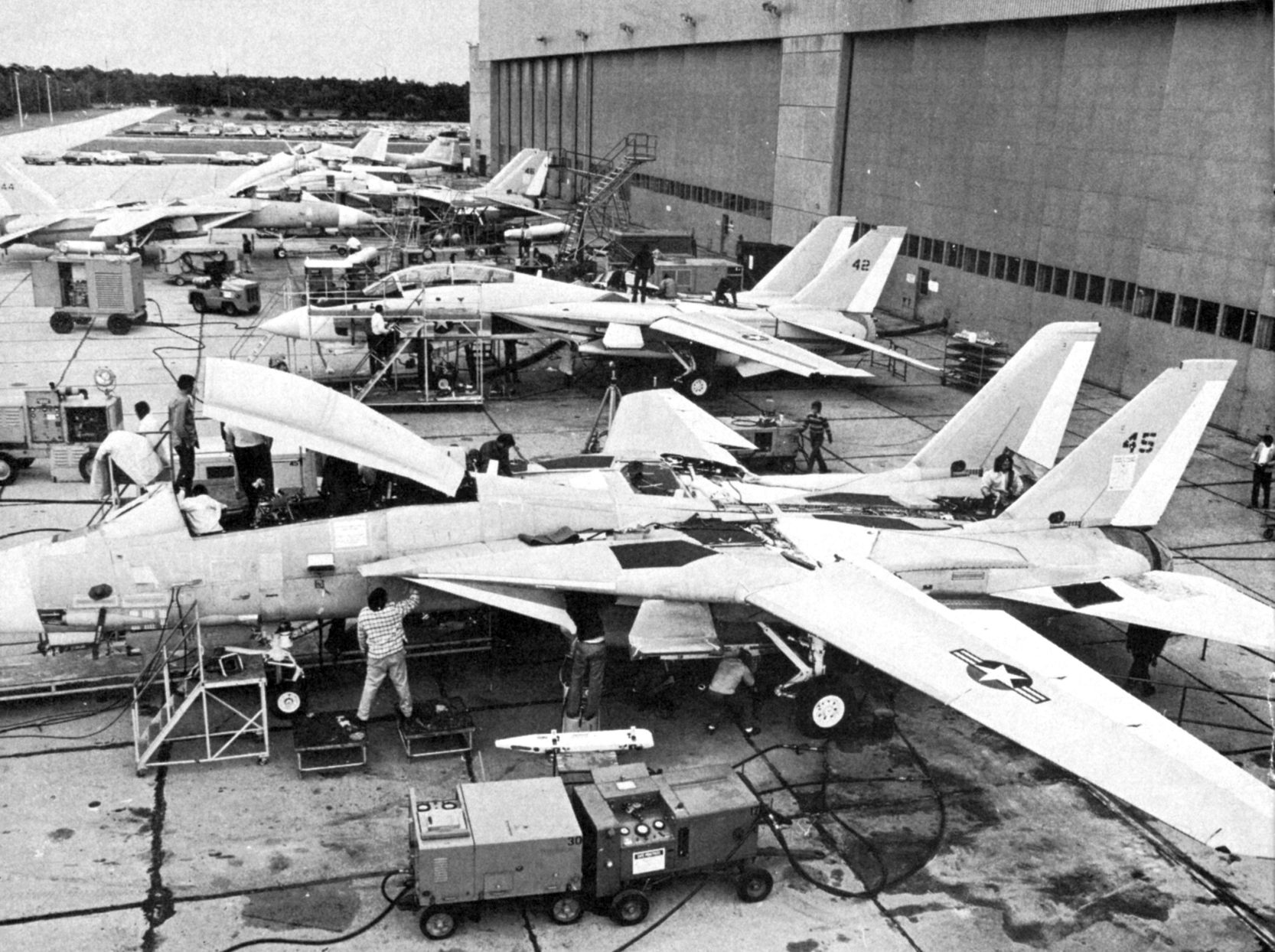
A 1974 photo of newly-built F-14 Tomcats & an A-6 Intruder outside Grumman's Calverton plant.
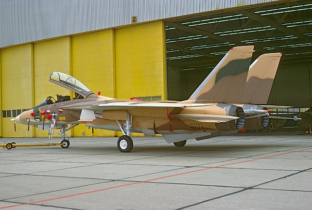
A 4/8/76 photo of F-14A Tomcat 160305 outside the Grumman Calverton plant just prior to its delivery to the Imperial Iranian Air Force.

A 1977 photo of a General Dynamics F-111A which had been modified by Grumman Calverton into an EF-111A prototype, taking off or landing at Calverton.
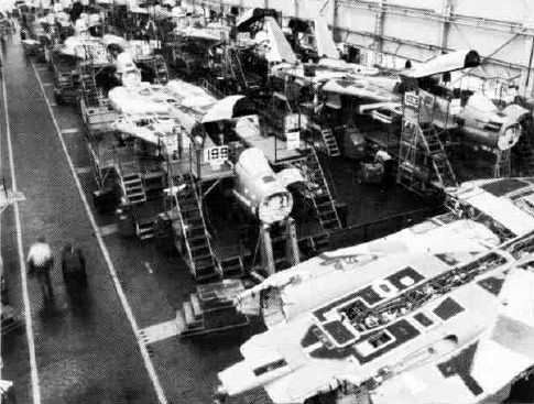
A 1980 photo of the Grumman Calverton F-14 Tomcat production line.
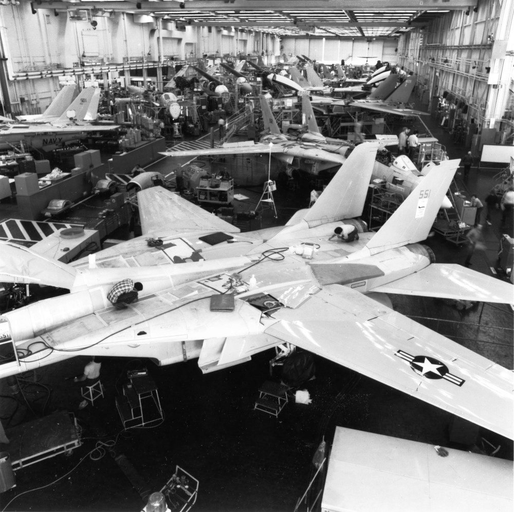
A 1980 photo of Grumman F-14 Tomcats & EA-6B Prowlers on the Calverton assembly line.
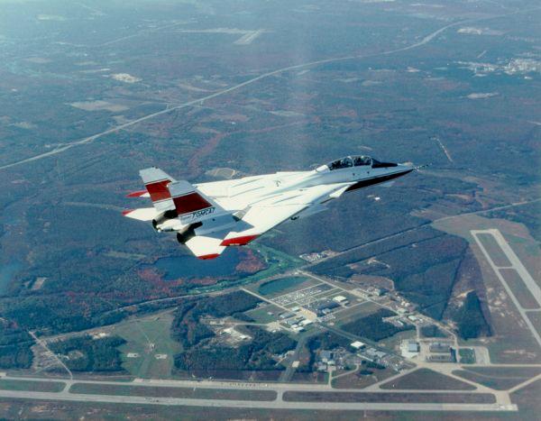
A 1990s aerial view (courtesy of Brett) of Grumman's F-14B Super Tomcat prototype overflying its birthplace, the Calverton plant.
A 1994 aerial view of the Peconic River Airfield, showing both runways still marked as active.
Grumman merged with Northrop Corporation in 1994, forming Northrop Grumman Corporation, and the new firm eliminated almost all operations on Long Island.
The sole remaining Grumman aircraft production line (for the E-2 Hawkeye) was consolidated to St. Augustine, FL.
Grumman vacated the Calverton site on 2/14/96.
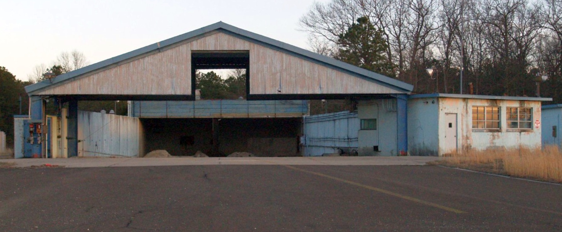
The NTSB leased a Calverton hangar at Calverton & used it to reassemble the wreckage of the TWA Flight 800 Boeing 747,
which had exploded on departure from JFK Airport on 7/17/96.
The reconstruction of the 93' section of the forward fuselage of TWA Flight 800 took place over the winter & spring of 1997 in a Calverton hangar.
The reconstruction of the Boeing 747 fuselage included the center wing fuel tank, the heaviest structural part of the plane.
It weighed 60,000 pounds, and consisted of almost 1,600 pieces, including more than 700 from the center wing fuel tank.
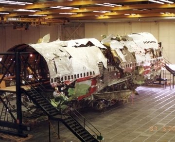
A 1997 photo of the reassembled wreckage of the TWA Flight 800 Boeing 747 inside a Calverton hangar.
The Peconic River Airfield property was turned over by the Navy to the Town of Riverhead in 1998.
A group named the Grumman Peconic Airfield Alliance was successful in convincing the local government to reopen the airfield.
It was reestablished as a private airfield for the use of a skydiving operation, Skydive Long Island,
which flew out of Calverton with a Twin Otter.
In the 1998 transactions, East End Aircraft Long Island Corporation was given 10 acres on Highway 25 intended to be developed into the Grumman Memorial Park & Aerospace Museum.

A circa 1990s-2000s photo of the Grumman Calverton plant & control tower.

A 9/21/03 photo of a Suffolk County Police MD Helicopters MD902 Explorer over a crowd at the Calverton Airfield.
Tom Kramer reported from an overflight in 2003 that "the eastern runway (14-32) has the white x's removed (blacked over) & new runway numbers painted on each end.
No displaced threshold so all 10,000' is available. The western runway is still closed.
There was also a Cessna parked on the ramp nearest the eastern runway."
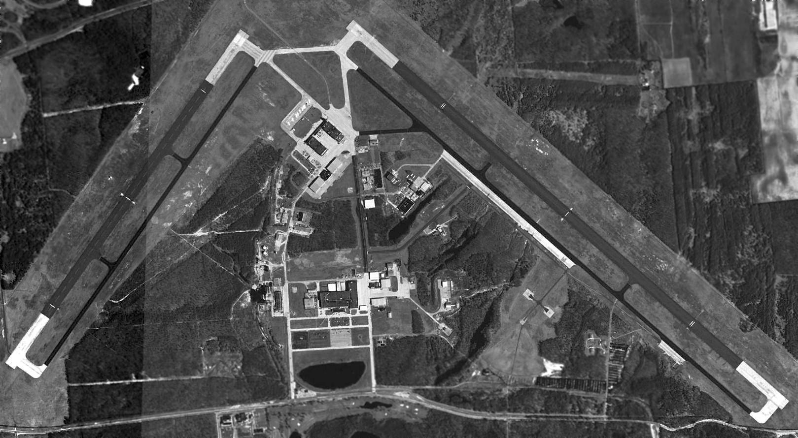
According to FAA Airport/Facility Directory data, Calverton Executive Airpark had 2 asphalt & concrete runways: 10,000' Runway 14/32 & 7,000' Runway 5/23.
According to Wikipedia, “As of January 2006, the Navy still owns 358 acres (mostly areas requiring environment cleanup) at the site.”
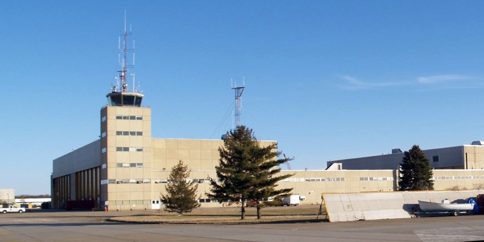
A 3/31/07 photo of the Grumman Calverton hangar & control tower.
A 3/31/07 photo of a Grumman Calverton hangar.
According to Wikipedia, “In January 2008, the Riverhead Town Board with newly-elected officers signed a deal to close & sell the airport for $155 million to Riverhead Resorts
which planned a 35-story ski mountain in a $2.2 billion proposed project.
In 2010 Riverhead canceled the contract after Resorts did not make a $3.9 million payment.”

A 3/1/10 aerial view looking northwest at the Calverton Airfield.
According to Wikipedia, “In January 2013, one of the Calverton airport's 2 runways is being used to store thousands of flood-damaged vehicles from Hurricane Sandy.
Development for the central portion of the complex is still undecided as of March 2018.
Various proposals have included building a racing track, a plant to build solar powered planes, building a solar farm, and building a large shopping center.”
The last photo which has been located showing planes at Calverton Executive Airpark was a 2015 aerial view.
A Cessna Caravan, a King Air, and a single-engine Cessna were seen near the Skydive Long Island hangar on the northeast side.
Calverton Executive Airpark's last remaining aviation tenant, Skydive Long Island, closed down in 2015.
Subsequent attempts to redevelop the Calverton facility called the site Enterprise Park at Calverton (EPCAL).
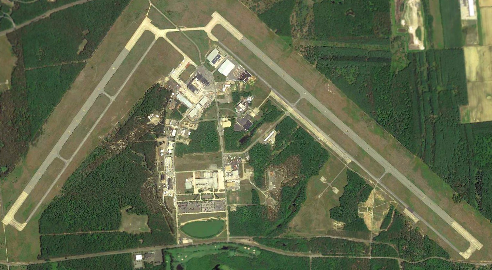
A 2018 aerial view of the Peconic River Airfield showed both runways marked with closed-runway “X” symbols.
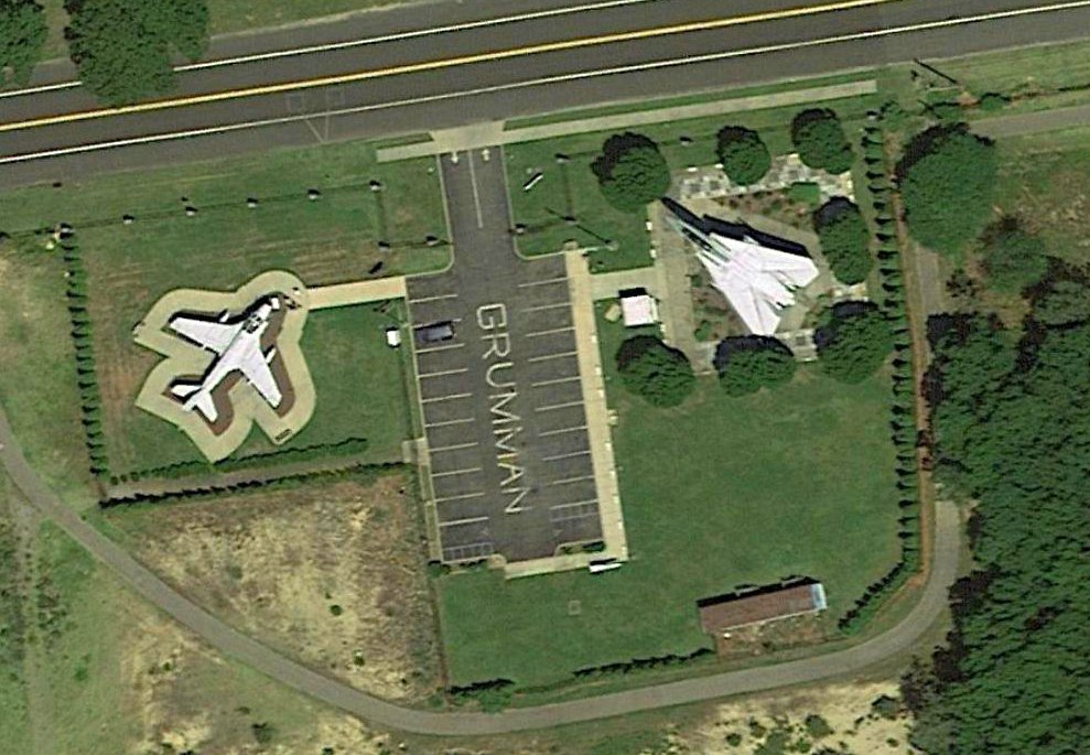
A 2018 aerial view of Grumman Memorial Park, on Route 25 along the north side of the Calverton property,
with its display of a Grumman A-6 Intruder & F-14 Tomcat.
Calverton Executive Airpark was still depicted on the 2019 NY Terminal Aeronautical Chart as having a 10,000' northwest/southeast runway, and to conduct skydiving operations,
even though it has evidently been effectively closed for a few years.
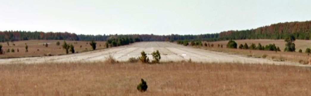
A 2019 photo looking southwest along the former Calverton Runway 23.
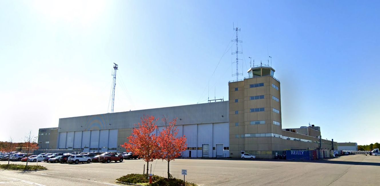
A 2019 photo looking south at the former Grumman Calverton hangar & control tower.
A pre-2022 aerial view looking east at the former Grumman Calverton hangar & control tower.
____________________________________________________
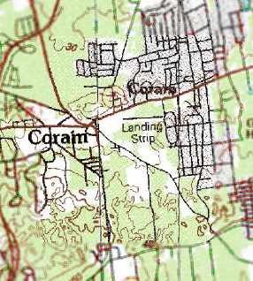
40.87, -72.99 (East of New York, NY)
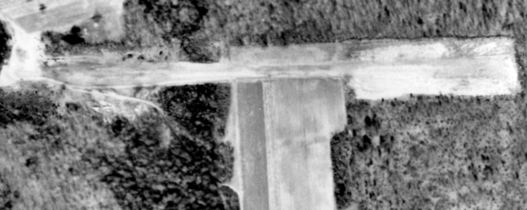
A 1962 aerial photo showed 6 single-engine aircraft parked northwest & southwest of the end of Coram's east/west runway.
No airfield was yet depicted at this location on a 1947 aerial photo.
According to Randy Davis, “By the 1950s, Lester Davis was flying his Piper PA-15 Vagabond off of his family’s farm in Coram.
By the early 1960s, he had laid out a dedicated turf/dirt runway oriented east/west.
This facility came to be known as the Coram Airpark.
In the early 1960s, Lester invited Tom Murphy to base his three Piper Cubs (2 PA-11s & 1 PA-18) at the field & operate a flight school.
Tom also had a Waco UPF-7 for hopping rides to visitors.
Tom was a well-known flight instructor on Long Island, had been an AT-6 military instructor during WW2.
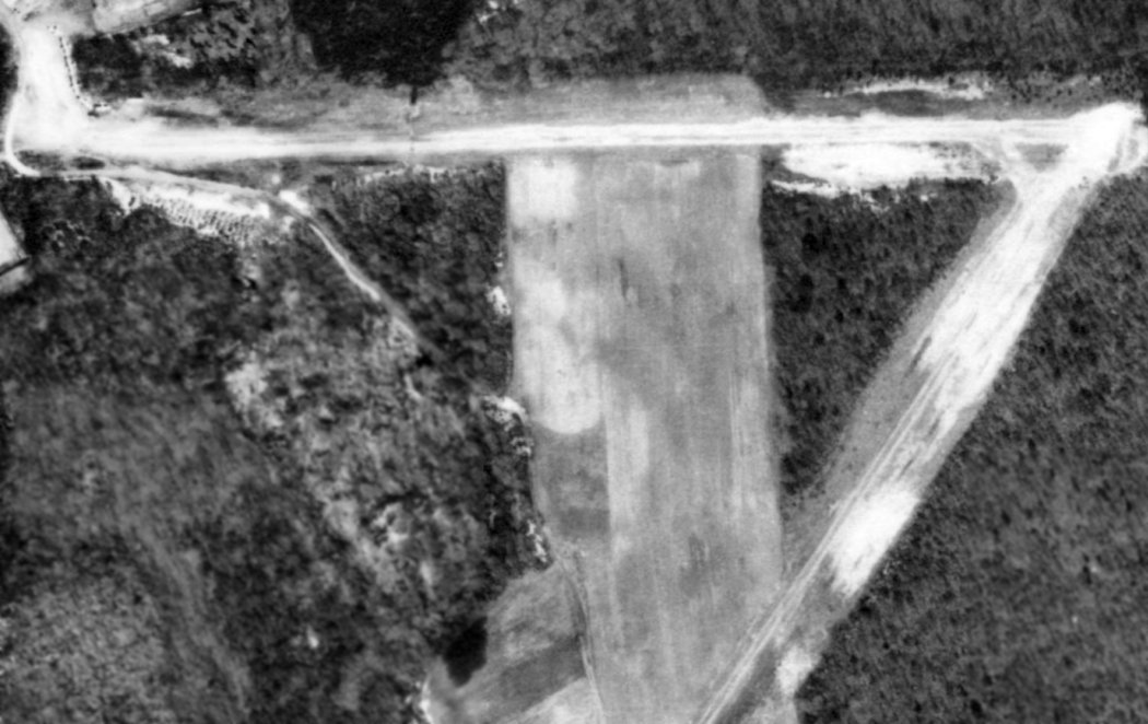
The earliest depiction which has been located of Coram Airport was a 1962 aerial photo,
which showed 6 single-engine aircraft parked northwest & southwest of the end of Coram's unpaved east/west runway.
Coram Airport was not yet depicted on the 1966 NY Sectional Chart.
A 3/29/66 USGS aerial view of Coram Airport depicted 6 single-engine aircraft parked next to a small building
(described as a dilapidated pilot lounge / workshop) on the north side of an unpaved runway.
The earliest aeronautical chart depiction which has been located of Coram Airport was on the 1967 NYC Local Aeronautical Chart.
It depicted Coram as a private field having a 2,200' unpaved runway.
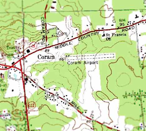
The earliest topo map depiction which has been located of Coram Airport was on the 1967 USGS topo map.
It depicted Coram Airport as having a single unpaved east/west runway, with a few small buildings on the northwest side.
According to Randy Davis, “By the end of the 1960s, Lester Davis had added an additional southeast/northeast runway.
Three of the runways had 90' trees at their approach ends.”
Tom operated his flight school at Coram Airpark for about 20 years.
Lester saw to it that all 3 of his sons (Randy, Lee, and Whitney Davis) learned to fly under Tom Murphy at the Coram Airpark.
Tom’s brother, Harry Murphy, a sign painter, would usually come out from Brooklyn & help out on weekends.
Tom was quite the character & philosopher, and his only shelter at Coram was a small building without electricity,
in which he would use hand tools to work on his planes & a small gas stove to make hot water for tea & coffee.
He also had several old chairs on which he would sit & share his thoughts with the many flight students who were drawn to him.
The Davis boys all remember many of Tom’s sayings & admonishments, such as:
'Pal, if you can learn to fly this thing out of this place, you will always be able to fly anything out of anywhere.'
'Pal, don’t be afraid of any airplane. Just give them full power, and they all take off.'
'Pal, some pilots who learn how to fly at big airports in modern planes simply have not been taught properly.
They try to land here at Coram sometimes, but it clear that they do not have any background.'
'It does not have to be difficult, Pal (to fly a certain maneuver that he was teaching) - your grandmother could do it.'
Randy continued, “Lester continued to fly, and bought a twin-engine Piper Apache in 1966, which he also based at Coram.
Lester’s sons went on to fly the Piper Vagabond & other airplanes out of Coram, including the Apache.
Randy also flew IFR in & out of Coram, and had the FAA issue an IFR airport designation (3N3) at one point in time.
In addition to Tom’s airplanes, about a dozen or so other planes, owned by various pilots, were based at Coram Airpark over the years.
These included a Cessna 120, a Cessna 172, Cessna 180, a Piper J-3 cub, a Stearman, a Beech T-34 Mentor,
Lester’s Piper Vagabond and Apache, and a couple of homebuilts.”
A 1972 aerial view looking northwest depicted Coram Airport as having 2 dirt runways,
with a northeast/southwest runway having been added at some point between 1967-72.
The 1972 NYC Terminal Control Area Chart depicted Coram as a public-use airport having a 1,900' unpaved runway.
John Dolan recalled, “Coram: This dirt strip was still open in the 1970s when I started flying.”
Gordon Brown recalled, “Coram Airpark... an instructor who taught there had well over 20,000 hours.”
A 1978 aerial photo showed 6 single-engine aircraft parked on the northwest side of the end of Coram's east/west runway.
Christian Bobka recalled, “I also learned to fly out of the Coram Airport in the late 1970s.”
Ralph Fisch recalled, “I spent many, many hours of riding my bike to watch the Cubs & an old Cessna 172 (straight tail) operate out of Coram Airpark.
I can see it so clearly in my mind's eye, right down to the house with wings hanging in the rafters, and the smell of the oil, dope, stale coffee & cigarettes.”
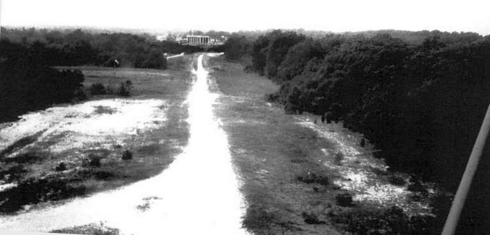
A circa 1980 aerial view looking west along Coram's east/west runway.
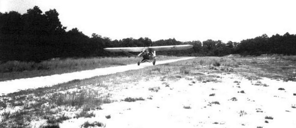
A circa 1980 photo of a Piper Cub landing on Coram's south runway.
The June 1982 NY Sectional Chart (courtesy of Mitchell Hymowitz)
depicted Coram as a private airfield having a 1,900' unpaved runway.
The last topo map depiction which has been located of Coram Airport was on the 1984 USGS topo map.
It depicted a single east/west runway, labeled simply as “Landing Strip”.
The last photo which has been located showing an aircraft at Coram Airport was a circa 1985 photo of Joshua Stoff checking the oil of a Piper Cub.
Richard Hughes recalled, “Coram Airpark... was a grass strip. It was an ultralight field.”
A 1984 aerial photo showed Coram in the same configuration as seen in the 1978 aerial photo, but devoid of any aircraft.
The last aeronautical chart depiction which has been located of Coram Airport
was on the December 1986 NY Sectional Chart (courtesy of Kevin O'Reilly).
It depicted Coram as a private airfield having a 2,300' unpaved runway.
Bruno Schreck recalled, “I think I was the last guy to land & takeoff from Coram Airport, in a 'real' airplane in about 1989.
I dropped off a client there in my Cessna 172RG Cutlass. It [Coram Airport] still showed on current charts of the time.
And I had called the listed airport operator about 2 weeks before to ask permission & about conditions.
I landed to the northeast at about sundown & taxied to the northwest ramp.
There were several ultralight operators putting away their aircraft when I taxied up. Those ultralight pilots seemed totally shocked.
As it happens, the guy I had talked to came over, but he had either forgotten that I had inquired, or that I had a 'real' plane (or both).
Since it was around sundown, with no runway lights, I don't think I even shut down the engine. I just made my drop-off & taxied back for takeoff.
But my client was impressed that he didn't have to take the Long Island Express, and his wife probably still doesn't believe how he got home from the city via New Jersey.”
Coram Airport was evidently abandoned at some point between 1989-93,
as it was no longer depicted on the December 1993 NY Sectional Chart (courtesy of Ron Plante).
A 1994 USGS aerial view showed Coram Airpark's 2 runways remained intact though deteriorated.
According to Randy Davis, “By the 1990s, Coram Airpark was closed, and Lester sold that part of the farm to Suffolk County, for open spaces preservation.
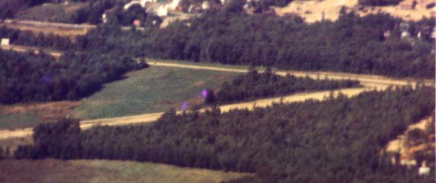
A 3/6/12 aerial view looking southwest showed that Coram's 2 runways remain intact almost 30 years after the airport was abandoned.
According to Randy Davis, “This land remains open & undeveloped even today. One can still make out the 2 old landing strips when looking at aerial views of the property.
Lester died in 2017. However, his legacy & memories of Coram Airpark live on,
within his sons & the many other pilots who learned to fly from Tom Murphy. They all have fond memories of the experience,
and the fine piloting skills that they acquired at the Coram Airpark.”
A 4/8/22 aerial view by Bob Mott looking south showed that Coram's 2 runways remain recognizable almost 40 years after the airport was abandoned.
The site of Coram Airport is located southeast of the intersection of Middle Country Road & Mt. Sinai Coram Road.
____________________________________________________
Sayville Airport, Sayville, NY
40.752, -73.084 (East of New York, NY)
Sayville Airport, as depicted on the June 1939 NY Sectional Chart.
This small general aviation airport was evidently established at some point between 1938-39,
as it was not yet listed among active airfields in The Airport Directory Company's 1937 Airport Directory (courtesy of Bob Rambo)
nor depicted on the November 1938 NY Sectional Chart.
The earliest depiction which has been located of Sayville Airport was on the June 1939 NY Sectional Chart,
which depicted Sayville as a commercial/municipal airport.
The earliest photo which has been located of Sayville Airport
was an 8/7/42 aerial view looking north from the 1945 AAF Airfield Directory (courtesy of Scott Murdock).
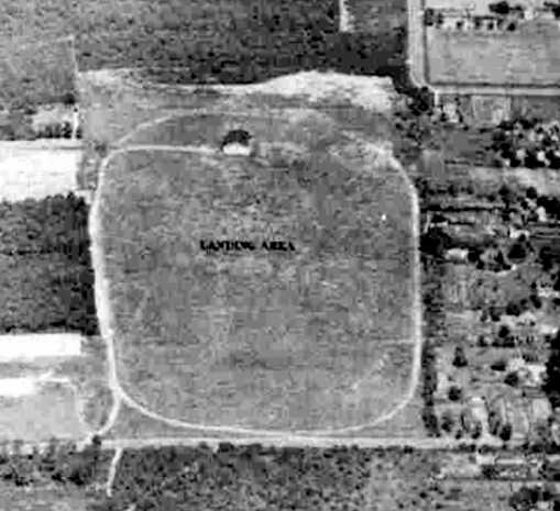
It depicted Sayville Airport as an oval-shaped grass landing area with a single hangar at the north end.
The 1945 AAF Airfield Directory (courtesy of Scott Murdock) described Sayville Airport
as a 22 acre rectangular property having a 1,500' north/south all-way sod field.
Sayville was described as having 2 metal & wood hangars, measuring 50' x 50' & 40' x 25'.
The field was said to be owned by private interests,
but “Not in operation” (most likely due to wartime security restrictions on small civilian airports near the coasts).
According to Webb Morrison, “The Sayville Airport was established [maybe reestablished?] by Allen Thomas & Philomena Farrell in 1945
and they opened the Long Island School of Aeronautics which, for veterans, qualified under the GI Bill of Rights.
The airport also offered the standard services of hangar storage, tie downs, and repairs.”
The last aeronautical chart depiction which has been located of the original Sayville Airport was on the July 1947 NY Sectional Chart,
which depicted Sayville as an auxiliary airfield.
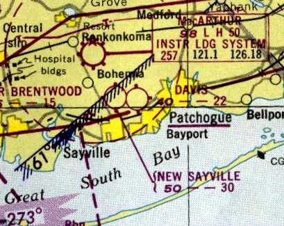
Note it also depicted the replacement New Sayville Airport to the north.
The last photo which has been located of the original Sayville Airport was a 1947 aerial view.
It depicted Sayville Airport as an oval-shaped grass landing area with a single hangar at the north end.
No planes were visible on the field.
The original Sayville Airport evidently closed (for reasons unknown) at some point between 1947-48,
as it was no longer depicted on the January 1948 NY Sectional Chart.
Charles Schnepp recalled, “Sayville Airport... I got my pilots license there in 1948.
It was a grass field with dirt runways & was located just a few miles south of McArthur Airport.
It was owned & operated by Al Thomas & Sis Farrell.
He was the instructor, she was the manager. They had no other employees.
65 years & 5,000 hours later, I will never forget them.”
The last depiction which has been located of the original Sayville Airport was on the 1949 USGS topo map,
which also depicted the replacement New Sayville Airport to the north.
A 1954 aerial photo showed the original Sayville Airport hangar remained standing,
and a majority of the airfield area remained clear, but development had started to intrude on the west & east sides.
A 1961 aerial photo showed the hangar remained standing.
A 1966 aerial photo showed the hangar had been removed, but its foundation was still visible.
A 1969 aerial photo showed the Lincoln Avenue Elementary School had been built over the site of the Sayville Airport hangar.
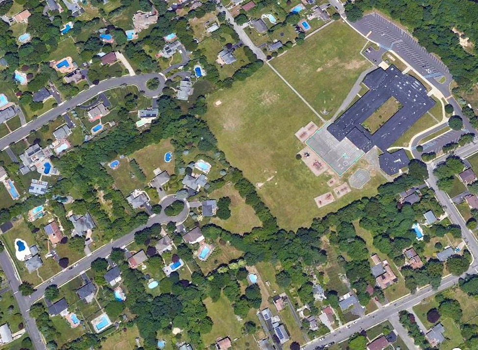
A 2018 aerial view looking northwest showed no remaining trace of the original Sayville Airport.
The site of the original Sayville Airport is located northwest of the intersection of Hopkins Street & Lincoln Avenue.
____________________________________________________
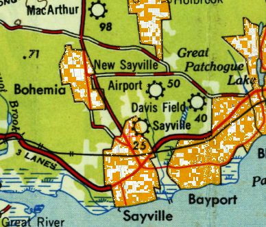
New Sayville Airport, Sayville, NY
40.762, -73.072 (East of New York, NY)
A 1947 aerial view of New Sayville Airport.
According to the Sayville Library, “Application was made to establish an airfield in a Residential 'A' district in December 1941.”
According to the Sayville Library, “After approval, in 1945 the land was bought by Allan Thomas who, in partnership with Philomena 'Sis' Farrell, opened the Airport.
Allen - an ex-Air Force Captain, licensed as a flight instructor in multi-engine & airline transport training courses
as well as a licensed airline captain in his own right - established the Long Island School of Aeronautics, a flying school.
The first student was George Maklos, a bus driver from Patchogue.
By October, 63 students were receiving instruction in Piper Cubs or a Stinson V-77,
many under the GI Bill of Rights, and the airport had 6 T-shaped hangars.
Among students were local physician Peter Lerner & local lawyer George McInerney; McInerney entertained at one airshow with aerobatics in a biplane.
A second popular show act was 'The Flying Farmer' in which Thomas demonstrated what NOT to do in the air.
A third advertised attraction were passenger flights including 'Night Flights Over Sayville' at $2.50 each.
Beyond various levels of flight instruction, the airport also offered standard services of hangar storage, tie-downs and repairs.
Allan Thomas was also a frequent volunteer participant in air searches for missing persons (and bodies).”
This small general aviation airport replaced the original Sayville Airport located just a half-mile to the south.
New Sayville Airport was not yet depicted on the July 1946 NY Sectional Chart.
The earliest depiction which has been located of New Sayville Airport was a 1947 aerial photo.
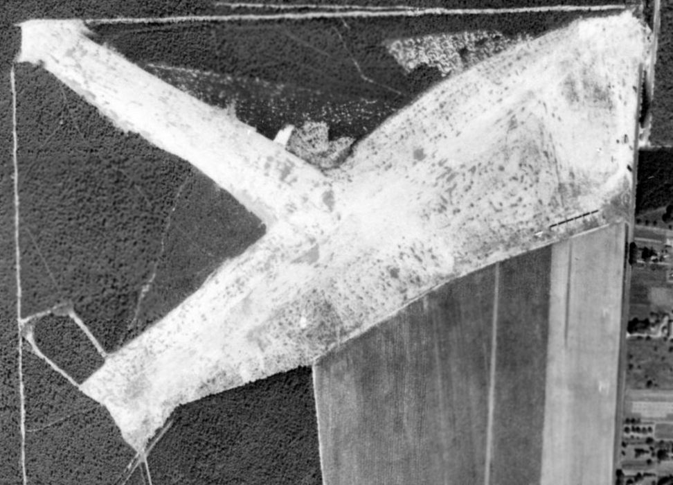
It depicted New Sayville as having 2 grass runways in an X-shape.
One single-engine aircraft & 6 individual T-hangars were visible on the southeast side.
The earliest aeronautical depiction which has been located of New Sayville Airport was on the July 1947 NY Sectional Chart,
which depicted New Sayville as a commercial/municipal airport.
The July 1949 NY Sectional Chart (courtesy of Ron Plante) depicted New Sayville as having a 3,000' unpaved runway.
The 1949 USGS topo map depicted both the New Sayville Airport & the predecessor Sayville Airport to the south.
The 1950 NY Sectional Chart depicted New Sayville Airport as having a 3,000' unpaved runway.
The last aeronautical depiction which has been located of New Sayville Airport was on the 1953 NY Terminal Chart.
It depicted Sayville as having a 3,000' unpaved runway.
A 4/7/54 aerial photo depicted New Sayville as having 2 grass runways in an X-shape.
A hangar, 7 individual T-hangars, and 4 single-engine aircraft were visible on the east side.
A Cessna T-50 Bamboo Bomber & another aircraft in the aftermath at New Sayville Airport from Hurricane Carol in September 1954.
Another view of the Cessna T-50 Bamboo Bomber in between some small buildings at New Sayville Airport after Hurricane Carol in September 1954.
According to Webb Morrison, “Unfortunately, Hurricane Carol in September 1954 destroyed both planes & hangars.
This - and also perhaps because of expanding services at nearby MacArthur [Airport] -
resulted in Thomas selling the 122 acres to developers in June 1955.
The Town returning the zoning to its original residential 'A' & the rest is history.”
New Sayville Airport was no longer depicted at all on the 1957 NY Sectional Chart (courtesy of Mike Keefe).
A 1961 aerial photo showed the abandoned New Sayville Airport,
with the 2 runways still remaining intact though deteriorated.
It appeared as if only the foundations remained of the hangar & T-hangars.
David Van Weele reported, “The landing field was removed probably in the early 1960s.
I worked on designing the housing development that is there now.
This is just south of Sayville Ford.”
A 1966 aerial photo showed houses covering the southern half of the airport site.
The northwest end of the runway remained recognizable, along with the foundation of the main hangar.
A 1969 aerial photo showed houses covering the remainder of the property,
erasing the last traces of New Sayville Airport.

A 3/6/12 aerial photo did not show any remaining trace of the New Sayville Airport.
The site of Sayville Airport is located southwest of the intersection of Broadway Avenue & Sunrise Highway.
____________________________________________________
Or if you prefer to contact me directly concerning a contribution (for a mailing address to send a check),
please contact me at: paulandterryfreeman@gmail.com
If you enjoy this web site, please support it with a financial contribution.
____________________________________________________
This site covers airfields in all 50 states.