Abandoned & Little-Known Airfields:
Northwestern Nevada
© 2002, © 2026 by Paul Freeman. Revised 2/7/26.
This site covers airfields in all 50 states: Click here for the site's main menu.
____________________________________________________
Please consider a financial contribution to support the continued growth & operation of this site.
Basecamp Airfield (revised 1/26/25) - Fernley Airfield (added 3/21/17) - Humboldt Intermediate Field (revised 11/30/20)
Lahontan Field (revised 6/13/21) - Lovelock Municipal Airport / Roberts Field / Lovelock Airpark (added 5/11/23) - Nevada Flyers Airfield / Spanish Springs Airport (revised 9/7/25)
Reno Air Mail Field / Blanchfield Field / Blanch Field (revised 12/14/12) - (Original) Reno Sky Ranch (revised 8/14/23) - Reno Skyline Airport (added 3/4/23)
Sparks Airport (added 2/7/26) - Sutcliffe NOLF / Sutcliffe Airport (revised 4/16/20) - Tahoe Sky-Harbor Airport (revised 7/9/22)
____________________________________________________
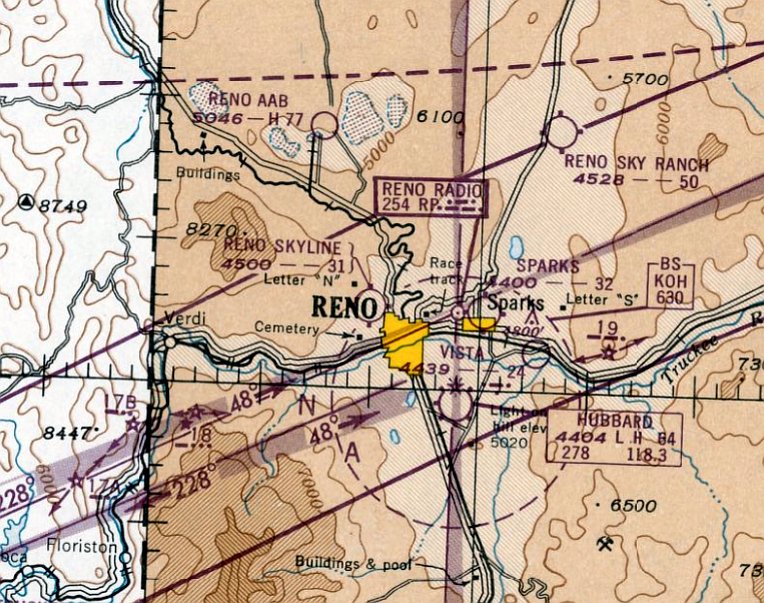
39.548, -119.749 (Northeast of Reno, NV)
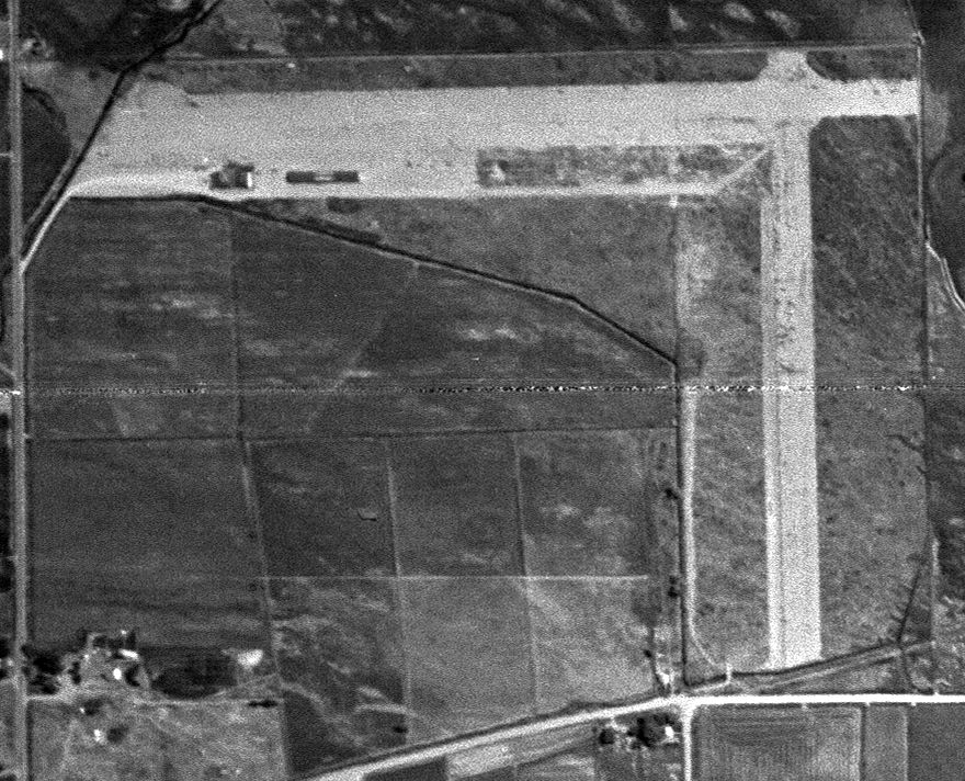
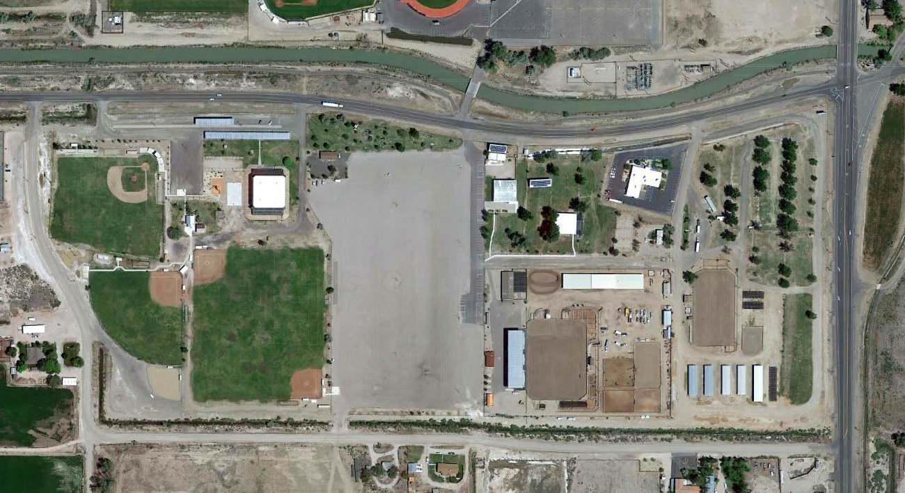
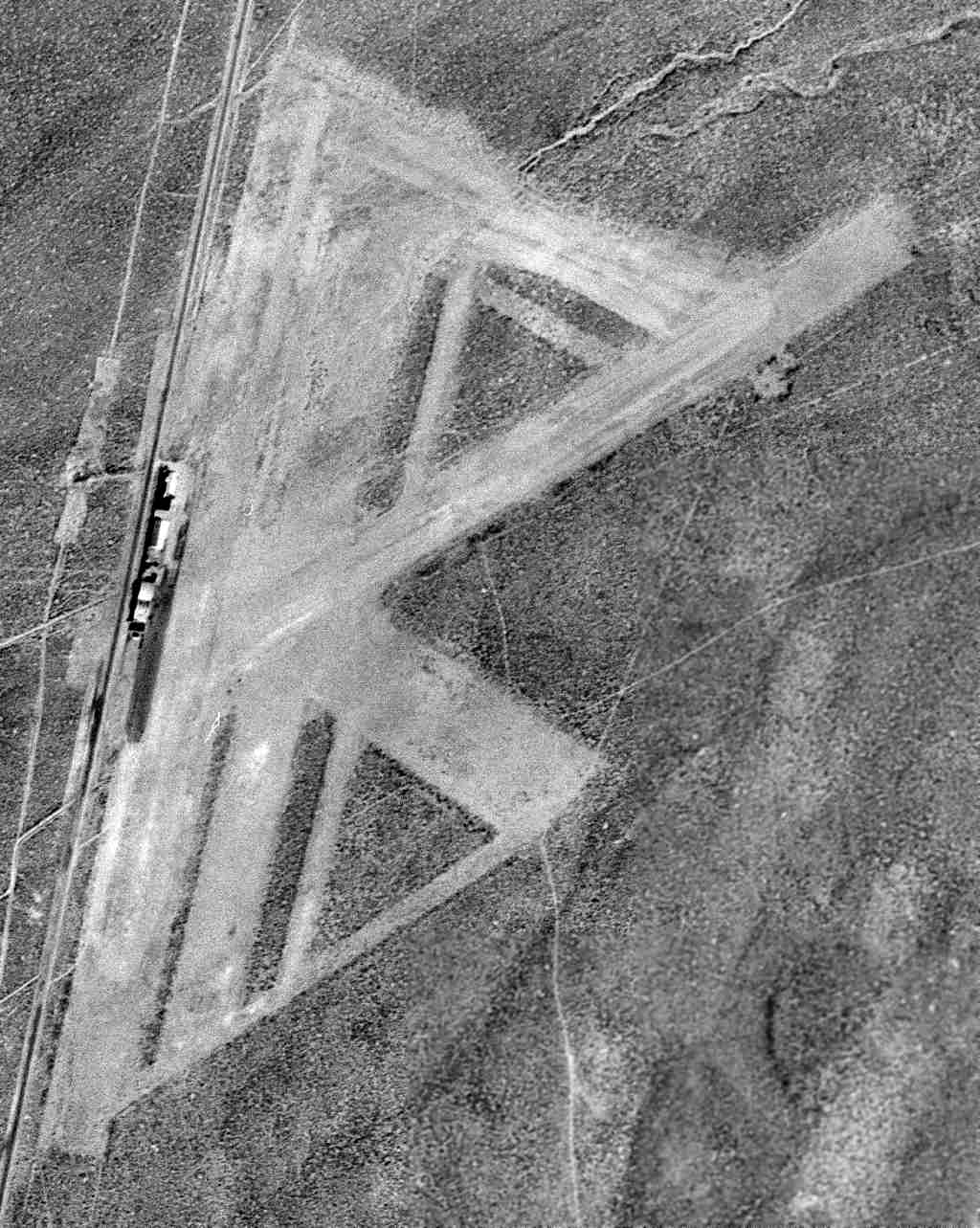
Sparks Airport, as depicted on a 7/10/46 USGS aerial view.
This short-lived small general aviation airport was located in the northern part of Sparks.
Sparks Airport was evidently established at some point between 1945-46
(like hundreds of other airports in the US post-WW2 aviation boom),
as it was not yet depicted on the May 1946 Reno Sectional Chart.
The earliest depiction which has been located of Sparks Airport was on a 7/10/46 USGS aerial photo.
It depicted Sparks as having 2 unpaved perpendicular runways, with 2 hangars along the southwest side.
The earliest aeronautical chart depiction which has been located of Sparks Airport was on the February 1947 Reno Sectional Chart.
It depicted Sparks as having a 3,600' unpaved runway.
The only photo which has been located showing aircraft at Sparks Airport was a 5/12/53 USGS aerial photo.
It depicted at least 16 light aircraft parked near the hangars on the southwest side.
The last aeronautical chart depiction which has been located of Sparks Airport was on the September 1953 Reno Sectional Chart.
It depicted Sparks as having a 3,800' unpaved runway.
Sparks Airport was evidently closed (for reasons unknown) at some point between 1953-54,
as it was no longer depicted on the March 1954 Reno Sectional Chart.
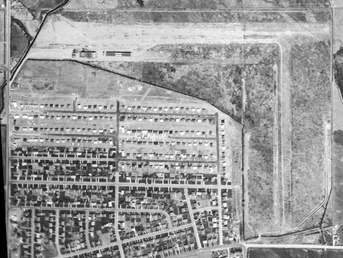
A 1956 USGS aerial photo showed that the site of Sparks Airport had been subsumed by the growth of the town of Sparks, but the hangars remained.
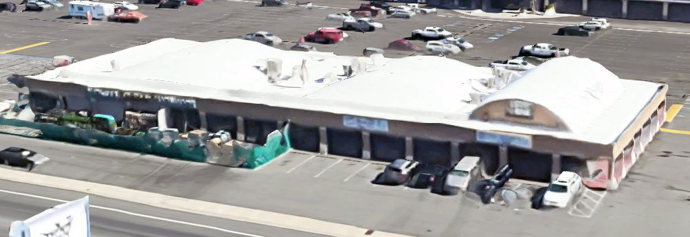
A 2025 3-D aerial image looking northwest showed the arch-roof hangars which remain along the southwest side of the Sparks Airport site.
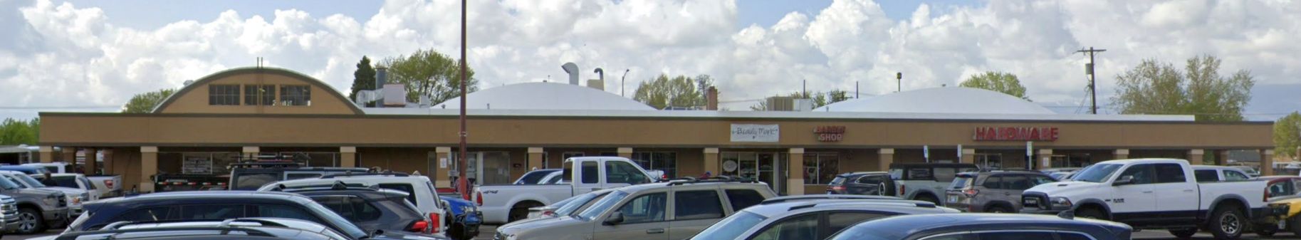
A 2025 photo looking south at the arch-roof hangars which remain along the southwest side of the Sparks Airport site.
Stephen Scheiding reported in 2025, “The hangars have been renovated several times with a facade surrounding the hangars.
The arched roofs are visible from the parking lot. The western-most part of the building is now an Ace Hardware store & an employee informed me that the owner was an aviation fan & that the building was once a hangar.”
Thanks to Stephen Scheiding for pointing out this airfield.
____________________________________________________
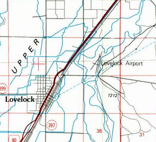
Lovelock Municipal Airport / Roberts Field / Lovelock Airpark, Lovelock, NV
40.191, -118.452 (Northeast of Reno, NV)
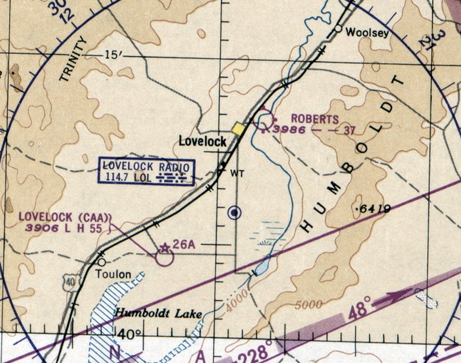
Lovelock Airport, as depicted on the June 1942 Elko Sectional Chart.
Jonathan Westerling reported, “The San Francisco to Salt Lake City Air Route ran miles south of Lovelock.
But as an outpost in the middle of a relatively sparse area, there was evidently a need for an airport to be established there,
even though the nation was freshly in the grips of the Second World War.”
The earliest depiction which has been located of Lovelock Airport was on the June 1942 Elko Sectional Chart (courtesy of Jonathan Westerling),
which depicted Lovelock Airport as an auxiliary airfield northeast of the town.
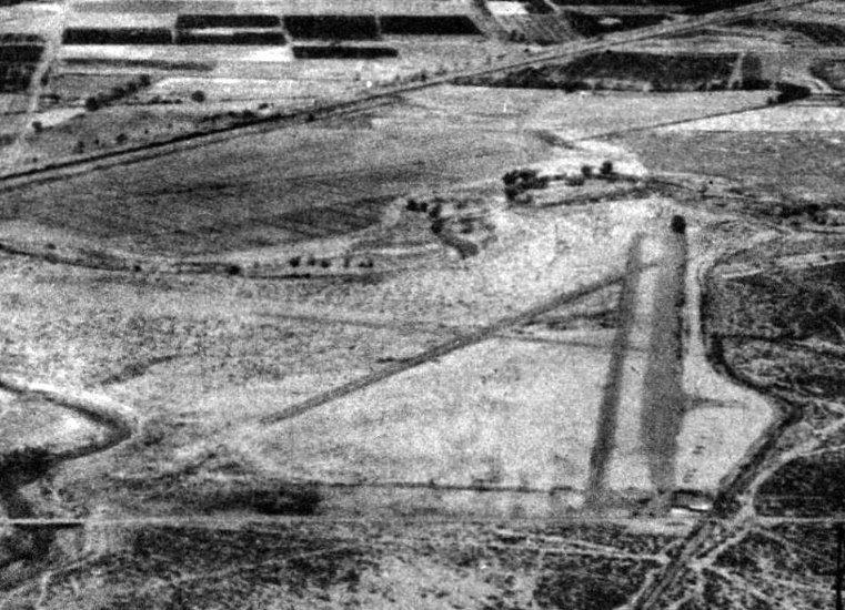
The earliest photo which has been located of Lovelock Airport was a 10/23/43 USAAF aerial view looking north (courtesy of AirCorps Library),
which depicted Lovelock Airport as having 3 unpaved runways, with a wide parallel taxiway on the east side, and a few small buildings on the southeast side.
The 1944 AAF Directory of Airports (courtesy of AirCorps Library) listed the "Old" Lovelock Municipal Airport as having 3 gravel runways, the longest being 3,100'.
Jonathan Westerling reported, “At the end of the War, Lovelock ended up with 3 airfields - each of them confusingly referred to as 'Lovelock' (according to the 1947 Decker's Guide).
One 'Emergency' field was located 19 miles east of town along the original Air Route (in the town of Humboldt).
Another had been constructed in 1943 by the Civil Aviation Administration 9 miles Southwest of Lovelock as an auxiliary airport for Fallon Field.
Presumably to avoid confusion, during this time the Lovelock Municipal Airport began to be referred to as Roberts Field after W. L. Roberts, the airport's manager.
The runway was also extended to 3,700' (according to the Haire Airport Directory).”
The 1950 Elko Sectional Chart depicted Roberts Field as having a 3,700' unpaved runway.
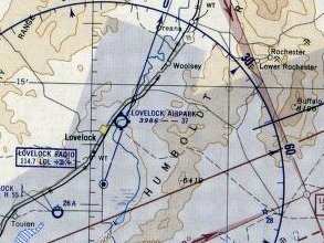
The 1952 Elko Sectional Chart (courtesy of Jonathan Westerling) depicted to the airport under a new name, Lovelock Airpark.
A 1954 aerial view depicted Lovelock Airport as having 3 unpaved runways & a wide parallel taxiway on the east side.
Two small buildings & 1 light aircraft were visible on the southeast side.
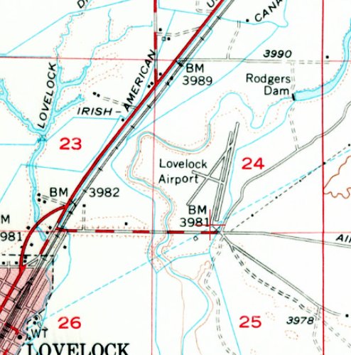
The earliest topo map depiction which has been located of Lovelock Airport was on the 1956 USGS topo map.
It depicted Lovelock Airport as having 3 unpaved runways & a parallel taxiway on the east side.
By 1959, Lovelock Airpark had extended its longest runway again to 4,300' (according to the July Airman's Guide).
Jonathan Westerling reported, “The last depiction of Lovelock Airpark on a Sectional Chart was in June 1960, and the airport was not included in any airport directories after this time.”
In spite of it having been dropped from Sectional Charts a decade prior, a 1972 aerial view (courtesy of the UCSB Library) showed 3 light single-engine planes parked on the south side of Lovelock Airport.
A 1980 aerial photo showed the I-80 Lovelock Bypass had been constructed through the northern portion of the Lovelock Airport property.
Two shorter unpaved runways remained on the south side of the highway.
Two small buildings & 1 light aircraft were visible on the southeast side.
The 1984 USGS topo map still depicted Lovelock Airport as having 3 unpaved runways & a parallel taxiway on the east side,
and did not yet depict the I-80 bypass which had already been built through the airport property.
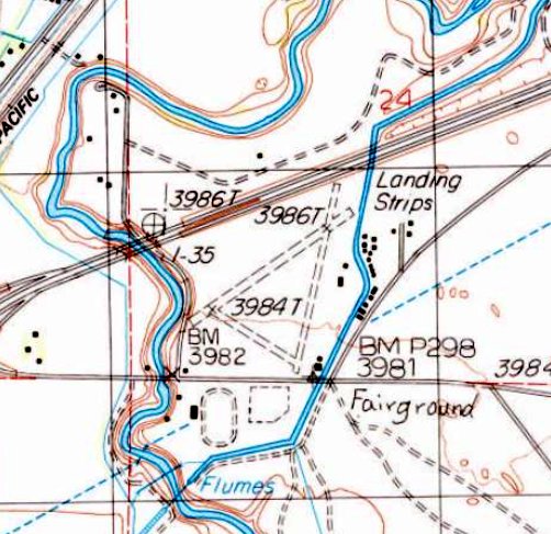
The 1987 USGS topo map depicted the I-80 bypass which been built through the northern portion of the Lovelock Airport property.
It showed 3 shorter unpaved runways on the south side of the highway, generically labeled as “Landing Strips”.
The last photo which has been located showing an aircraft at Lovelock Airport was a 1994 aerial view,
which showed 1 light single-engine plane on the southeast side.
Aerial photos from 2006-2019 no longer showed any aircraft at Lovelock Airport.
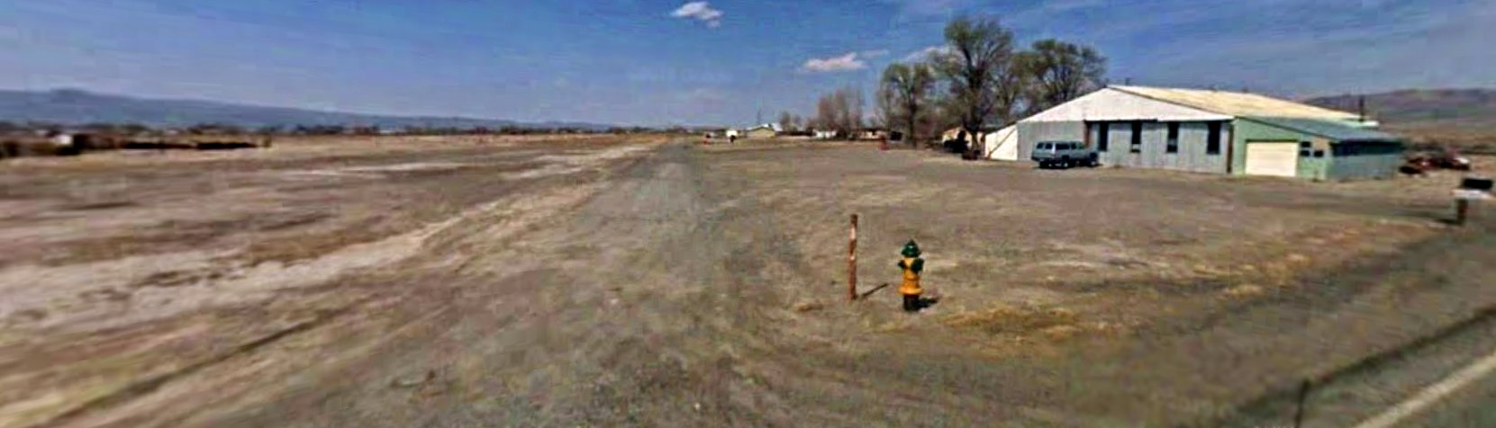
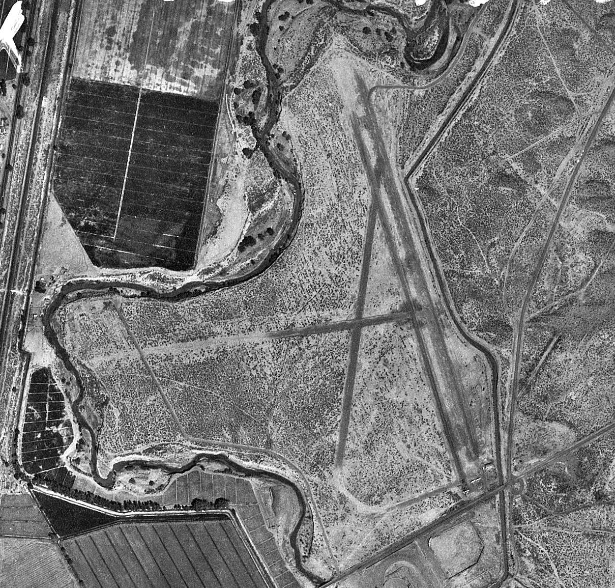
A 2009 photo looking north showed the former Lovelock Airport northeast/southwest runway, and a former hangar remaining on the southeast corner.
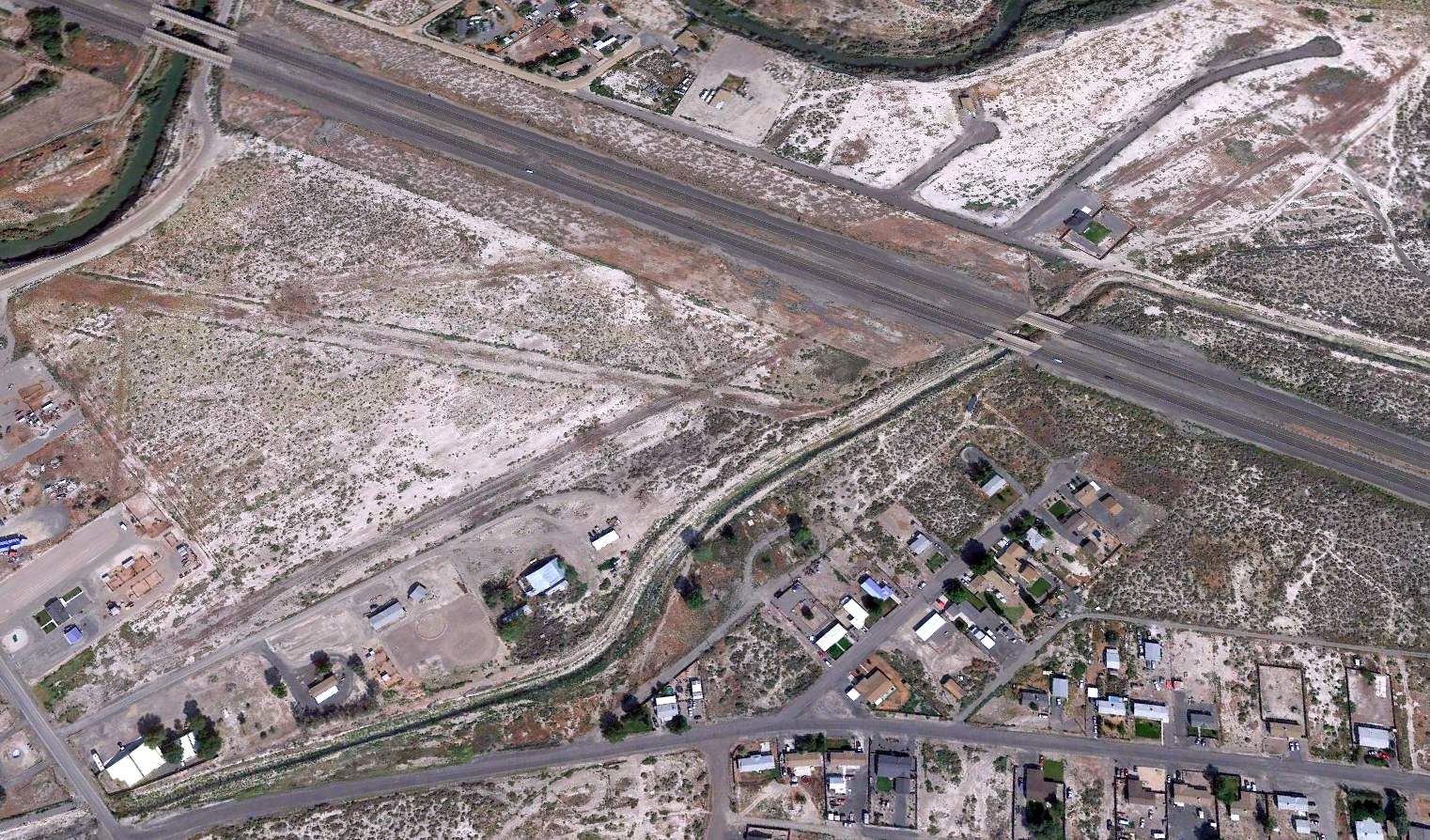
A 2015 aerial view looking northwest at Lovelock Airport showed traces of the 2 older runways (both south & north of I-81), along with the newer northeast/southwest runway built on the south side of the highway,
along with several former hangars along the southeast side.
Lovelock Airpark is located at the intersection of Glenn Lane & Airport Road, appropriately enough.
____________________________________________________
Reno Skyline Airport, Reno, NV
39.536, -119.849 (Northwest of Central Reno, NV)
Reno Skyline Airport, as depicted on the February 1948 Reno Sectional Chart.
This general aviation airport to the northwest of Reno was evidently established at some point between 1944-49,
as it was not yet depicted on the March 1944 Reno Sectional Chart.
The earliest depiction which has been located of Reno Skyline Airport was on the February 1949 Reno Sectional Chart.
It depicted Reno Skyline Airport as having a 3,100' unpaved runway.
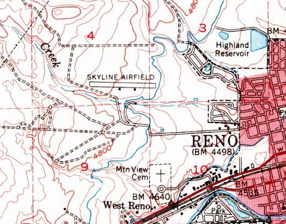
The earliest topo map depiction which has been located of Skyline Airport was on the 1950 USGS topo map.
It depicted Skyline Airfield as having a single east/west paved runway, with 2 small buildings on the south side.
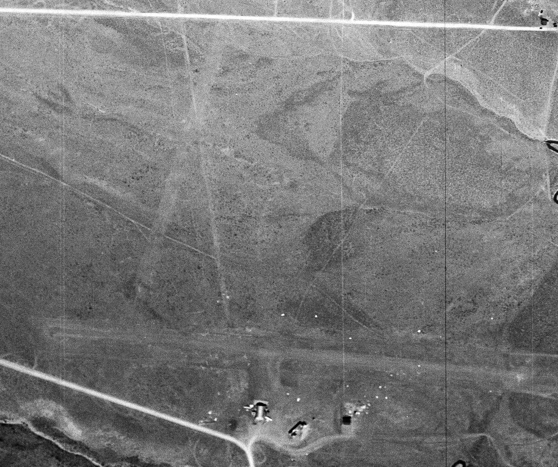
The only photo which has been located of Skyline Airport was a 4/14/53 USGS aerial view.
It depicted Skyline Airfield as having 2 unpaved runways, with a few small buildings & 2 light single-engine aircraft on the south side.
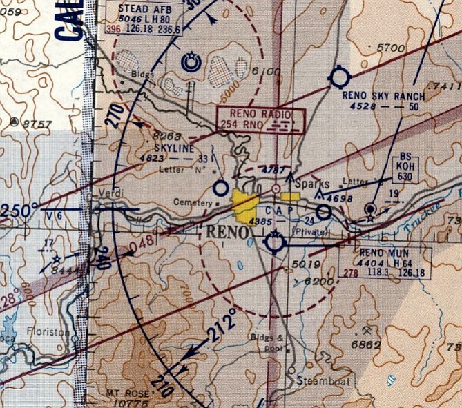
The last depiction which has been located of Skyline Airport was on the October 1954 Reno Sectional Chart.
It depicted Skyline Airport as having a 3,300' unpaved runway.
Skyline Airport was evidently closed (for reasons unknown) at some point between 1954-57,
as it was no longer depicted on the September 1957 Reno Sectional Chart.
According to Paul Bouillon, Skyline “was a satellite field for Stead & it had a larger hangar than Reno Airport did for quite a while.
It was there through the 1950s & 1960s.”
The 1963 USGS topo map depicted Skyline Airfield in an unchanged fashion.
A 1966 aerial view showed no trace remaining of Skyline Airport, with 2 schools having been built over the site.
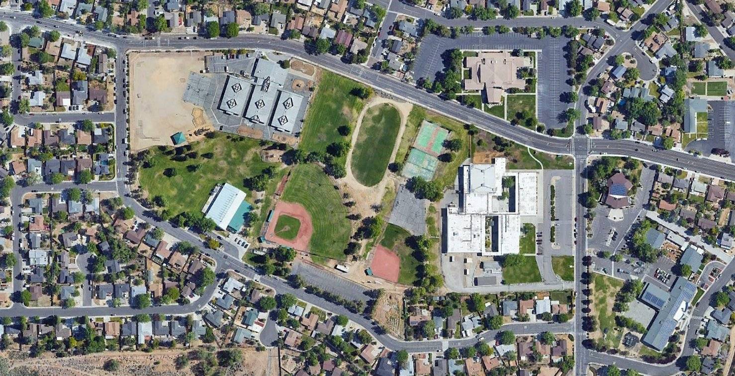
A 2022 aerial view showed no trace remaining of Skyline Airport, with Mamie Towles Elementary School, Archie Clayton Middle School, and houses covering the site.
Thanks to Paul Bouillon for pointing out this airfield.
____________________________________________________
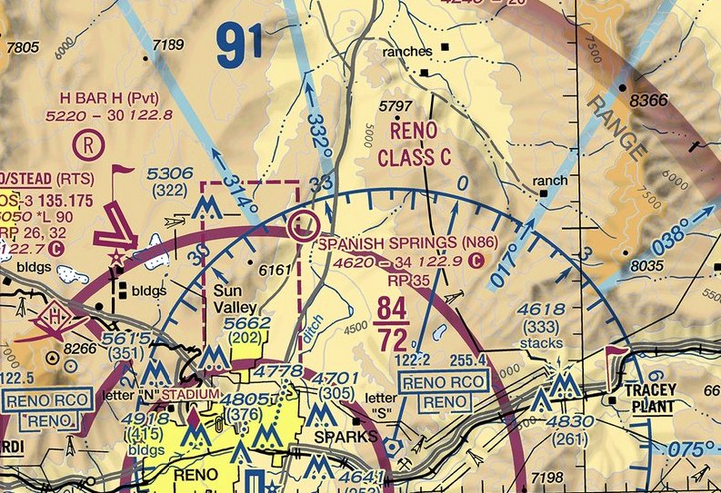
Nevada Flyers Airfield (NV18) / Spanish Springs Airport (N86), Reno, NV
39.672, -119.725 (North of Central Reno, NV)
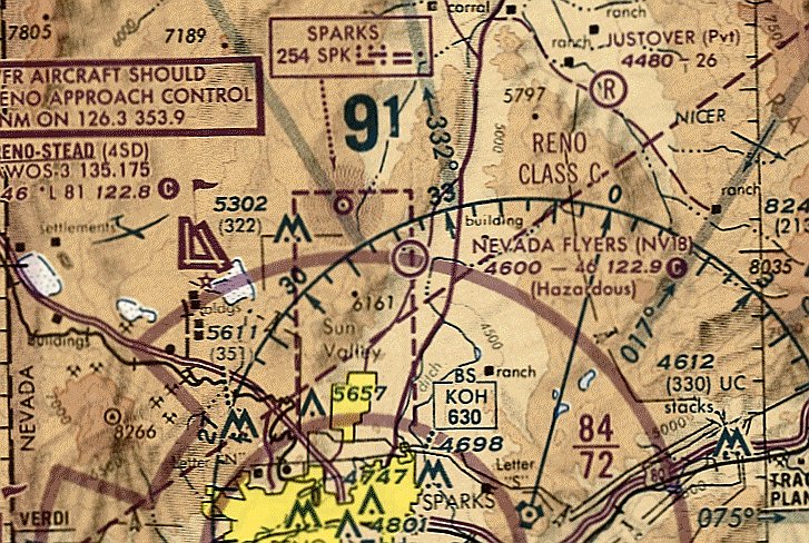
Nevada Flyers Airfield, as depicted on the October 1993 San Francisco Sectional Chart (courtesy of Ron Plante).
No airfield was yet depicted at this location on a 1954 aerial photo.
According to Keith Wood, “This field was build to replace Sky Ranch Field circa 1970. It was open to the public & on public land.
When built, the airport was in empty land, with a 1-mile dirt access trail from Eagle Canyon Road, which serves the Reno-Sparks Paiute Indian Colony.”
According to the FAA Airport/Facility Directory, this small general aviation airport was activated in August 1971.
However, Nevada Flyers Airfield was not yet depicted on the November 1971 San Francisco Sectional Chart (courtesy of Ron Plante).
According to Keith Wood, “A crosswind runway was graded, but little used.”
The earliest photo which has been located of Nevada Flyers Airfield was a 1975 aerial view.
It depicted 2 unpaved runways: north/south with a parallel taxiway, and northwest/southeast.
No buildings, ramps, or aircraft were visible – nothing but the 2 bare runways & taxiway.
No airfield was depicted at this location on the 1980 USGS topo map.
The earliest depiction which is available of Nevada Flyers Airfield was on the October 1993 San Francisco Sectional Chart (courtesy of Ron Plante).
It depicted Nevada Flyers Airfield as having a 4,600' unpaved runway, and to be Hazardous.
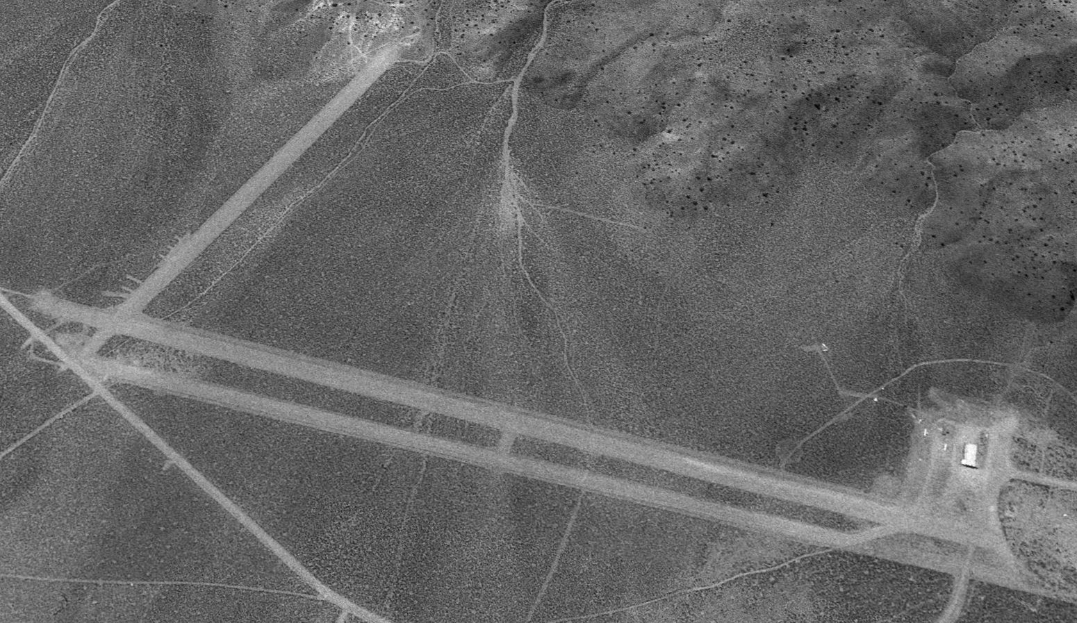
The earliest photo which is available of Nevada Flyers Airfield was a 1994 USGS aerial view looking west.
It depicted Nevada Flyers Airfield as having 3 unpaved runways, and a hangar which had been added at some point between 1975-94 on the northwest side.
Two light single-engine planes were parked near the hangar.
Note the complete lack of any other development anywhere around the airfield – just bare desert.
Nevada Flyers Airfield was evidently renamed Spanish Springs Airport at some point between 1993-97,
as that is how it was labeled on the September 1997 San Francisco Sectional Chart (courtesy of Ron Plante).
A 2002 aerial photo showed Spanish Springs Airport in much the same configuration, and housing had not yet encroached on the periphery.
A 2004 aerial photo showed dense suburban housing being constructed directly adjacent to the east side of Spanish Springs Airport.
An explanation for the dense surrounding development came from Keith Wood:
“When Rocketdyne sold off their Nevada Test Facility, it went to McCulloch, who planned to test a drone that they thought the Army would buy.
Then they discovered that the airfield didn't belong to Rocketdyne, so a deal was made to grade a new airport, 2 miles away.
What little resistance the BLM might have had at the time was overcome by political pressure on behalf of 2 big corporations from 2 different states,
and there was nothing out there anyway.
McCulloch didn't get the drone contract, and didn't need all of those square miles of empty land, so the sold it for development.
All of the homes you see north of Baring Boulevard & between the Indian colonies at Sutcliffe, Nixon, Wadsworth & over by Stead have been built since 1972.
With the development came people who wanted the airport closed, and their political pressure did the job.
The irony is that they wouldn't be there in the first place if not for the deal that created the airport.”
Keith Wood reported, “For a decade after housing development drastically shortened the airport entrance road, the airport still had its original Eagle Canyon Road mailing address,
to the confusion of every newly-assigned postal delivery driver.
A crosswind runway was finally abandoned in the early 2000s, when housing development encroachment made this runway less useful.
The primary runway was well-maintained, but had little room for under-or overrun due to the development on the south end & a tall dirt berm between the airport & a quarrying operation to the north.
As this runway sloped upward to the north, it was common for pilots taking off to the north to veer right to avoid the berm,
until a large commercial distribution center was built there, which would have required flying low overhead.
The only pavement was there to enable planes to taxi to the upper level of hangars, where the run-up area & the fuel station were located.”
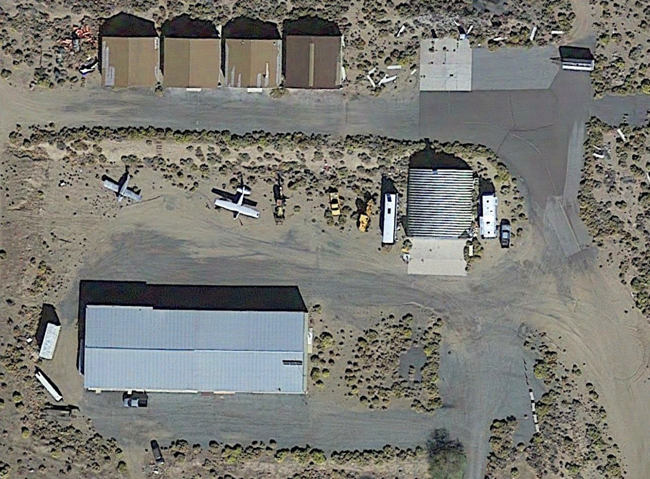
Keith continued, “At its height, there were 13 hangars & over 20 aircraft based at Spanish Springs,
and it was also used by Washoe County Search & Rescue,
transient traffic visiting the Reno area for events such as the National Championship Air Races, the annual Tailhook Association convention, and others.”
There was onsite security & fuel service, part-time aircraft repair & inspection, and periodic open house/fly-in events.
It was also very popular with local flight instructors, who wanted to train students on flying from graded dirt runways & those with terrain challenges.
A number of sailplanes found Spanish Springs a welcome alternate landing strip, when wind changes made it impossible to safely return to Air Sailing, a few miles away.”
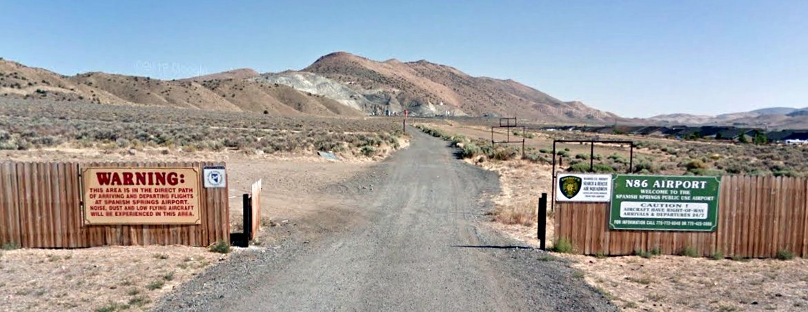
An August 2011 photo looking north at the Spanish Springs Airport entrance signs.
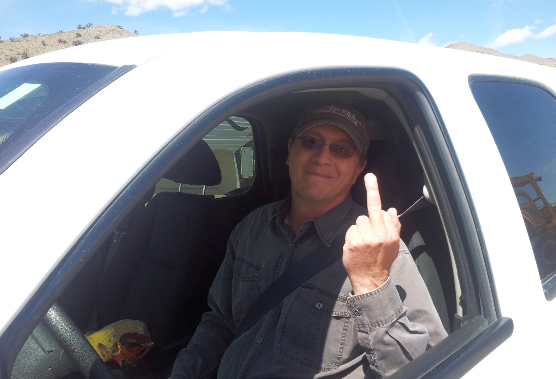
A 2013 photo by Keith Wood at Spanish Springs Airport.
Keith reported, the photo is “of a Bureau of Land Management bureaucrat, who refused to provide proof of that status to the security officer who found him wandering around the hangars.”
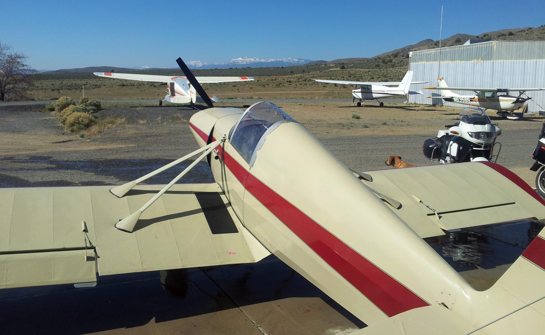
A 2013 photo by Keith Wood of “several aircraft based at Spanish Springs.”
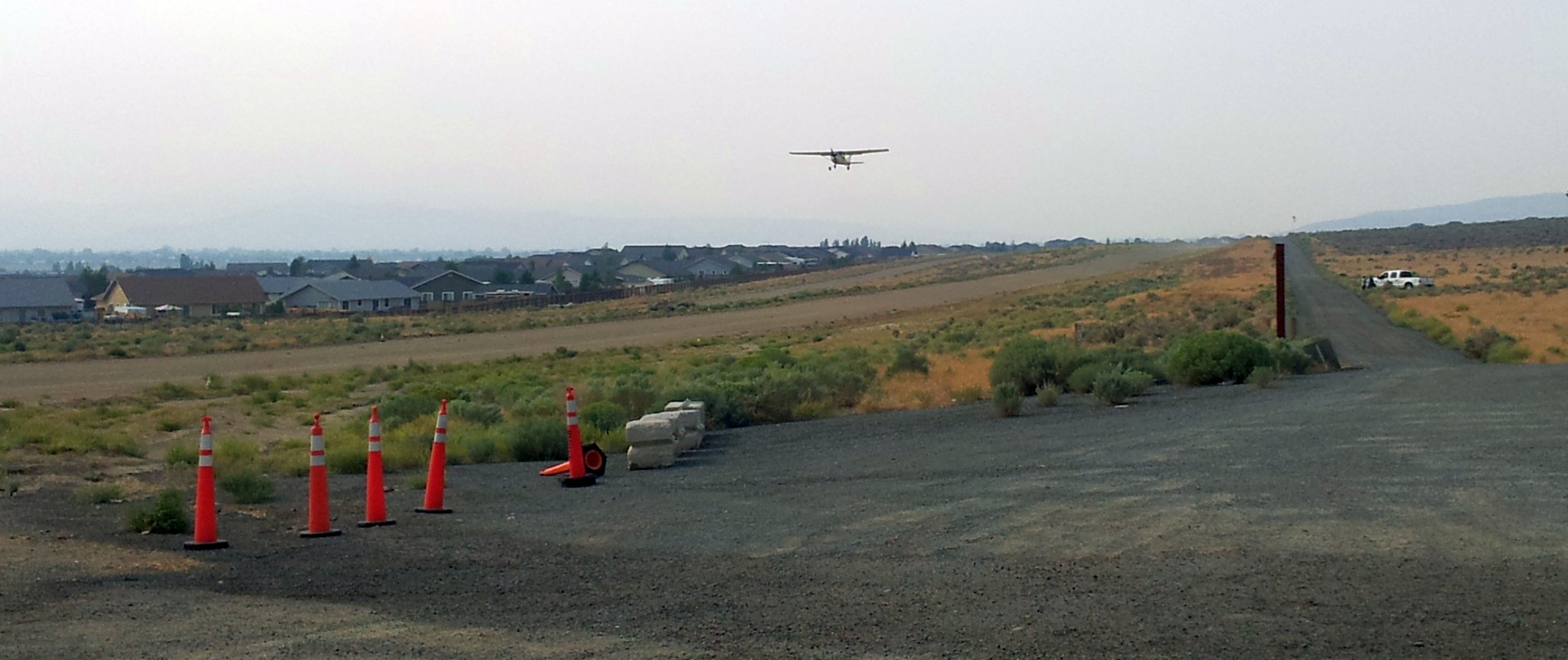
A 2013 photo by Keith Wood looking south at Spanish Springs Airport, showing “a Cessna 150 taking off northbound, the slope of the runway being visible.”
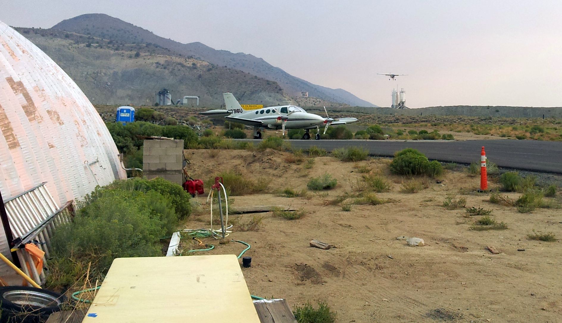
A 2013 photo by Keith Wood looking north at Spanish Springs Airport, showing “the Cessna 150 on approach from the north, looking over the paved taxiway leading to the fuel station and run-up area.”
The 2014 USGS topo map depicted Spanish Springs Airport as having a single north/south runway.
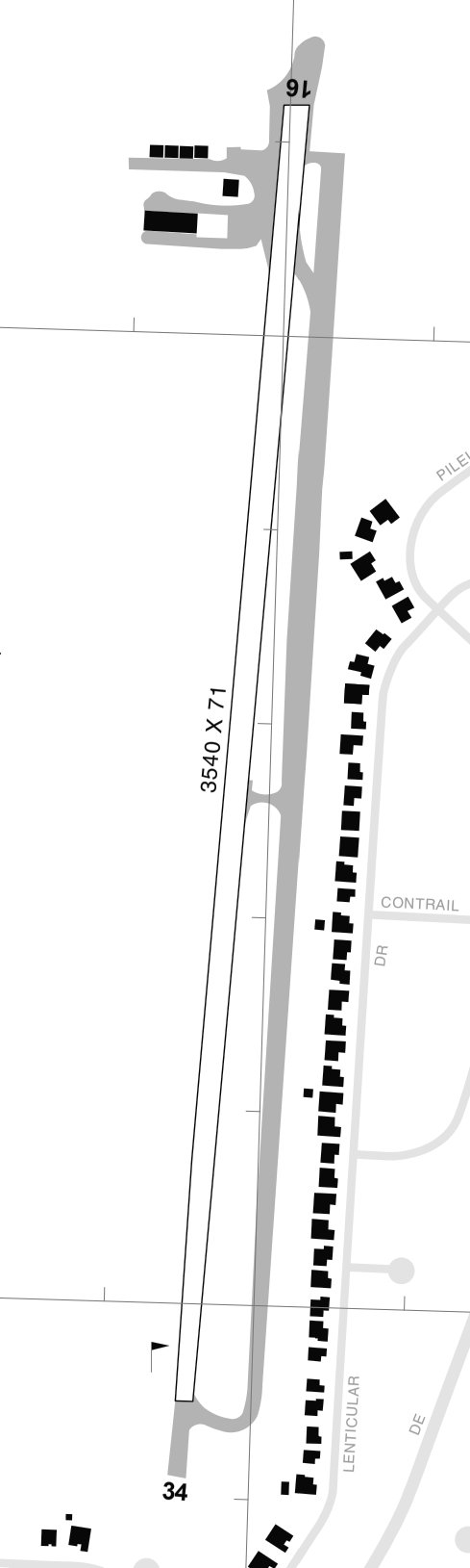
The 2014 NV Airport Directory depicted Spanish Springs Airport as having a single 3,540' Runway 16/34 & parallel taxiway, with ramps & 6 small buildings on the northwest side.
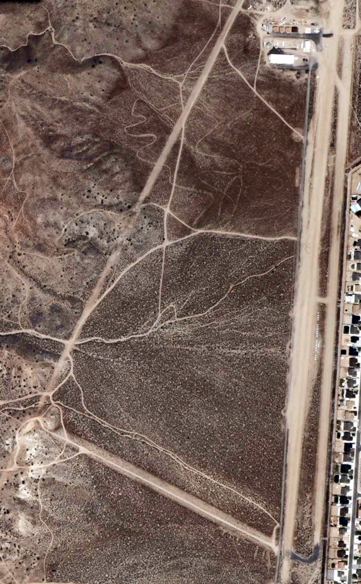
A undated aerial view from the 2014 NV Airport Directory depicted Spanish Springs Airport as having 2 unpaved runways,
with ramps, several small buildings & several light aircraft on the northwest side.
Keith Wood reported, “The BLM wanted the field closed down, and kept coming up with new obstacles for years.
About 5 years ago [circa 2017] they demanded that the hangars be painted to blend in with the surrounding land,
and specified a color that doesn't actually exist, which no paint company on the planet makes.”
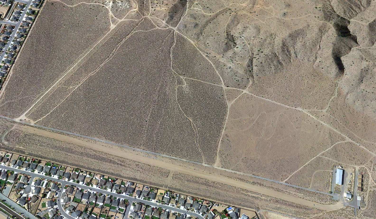
A 2020 aerial view looking west depicted Spanish Springs Airport as having 2 unpaved runways,
with ramps, several small buildings & several light aircraft on the northwest side.
A 2020 aerial view depicted 2 light single-engine planes among the Spanish Springs Airport hangars.
Unfortunately, Keith Wood reported, “All of this ended due to bureaucratic whim.
The Bureau of Land Management kept putting obstacles in the way of renewing the lease, finally canceling it in 2022.
As of October, 2022, the hangars were in the process of being removed, with the materials to be repurposed.
Only one hangar was to be put back to work in aviation.
The aircraft formerly based at Spanish Springs have relocated, with some as far away as Silver Springs, 50 miles distant.”
The 2022 Sectional Chart depicted Spanish Springs Airport as having a 3,400' unpaved runway.
As of 2022, the FAA Airport/Facility Directory described Spanish Springs Airport as Closed indefinitely.
It was said to have a single 3,418' dirt Runway 17/35, “in fair condition”,
to be publicly-owned by the Spanish Springs Pilot Association, and managed by Max Bartmess.
It was said to have only 3 single-engine based aircraft.
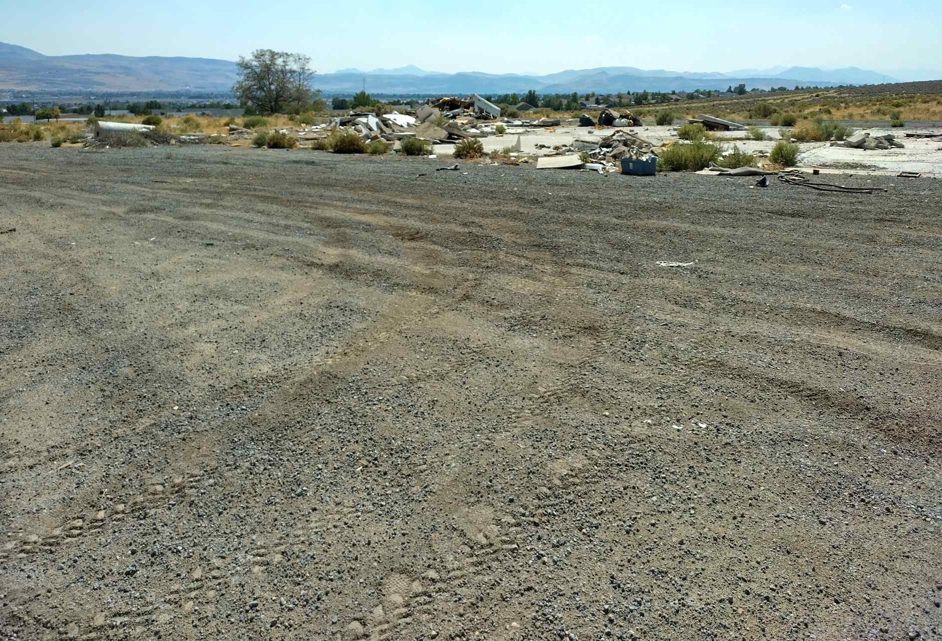
A 9/6/25 photo by Keith Wood of the Spanish Springs Airport ramp & remains.
Keith Wood reported, “What had been a popular & useful airport was closed because the Fern Fascists and local real estate agents thought that it was unsightly,
and got the Bureau of Land Management to impose higher lease rates & costly changes, some of which were impossible to meet.
For instance, one of their demands a couple of years before closure was that all of the hangars had to be painted a color that they did not define
and which no paint company we could find actually made -- but it had to make them blend into the surrounding desert.
They ignored explanations that you WANT an airport to be seen standing out from the surrounding ground!
So, they got their way... this sure looks a lot better than all of those ugly hangars & airplanes, doesn't it?
And, while it had been an airport, only planes used the place, enforced by live-on-premises security.
Now the whole area is a playground for dirt bikes, UTVs, buggies without mufflers, etc., with numerous tire tracks down the runway, near the homes.
There have been fires & dumping, while the Bureau of Land (Mis)Management - who intentionally made it impossible to keep the airport open - has ignored the problem.”
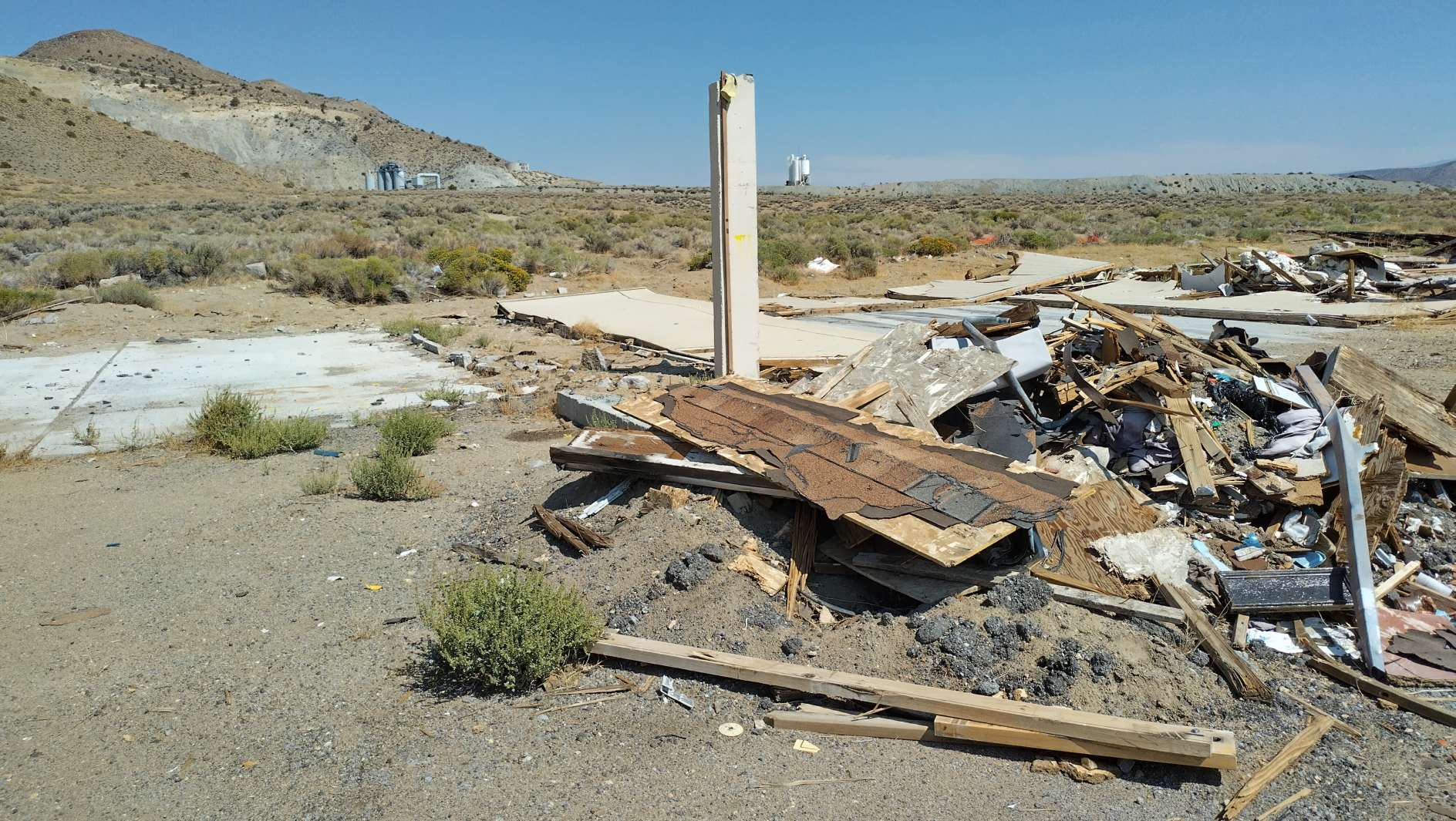
A 9/6/25 photo by Keith Wood of remains of Spanish Springs Airport hangars.
Thanks to Keith Wood for pointing out this airfield.
____________________________________________________
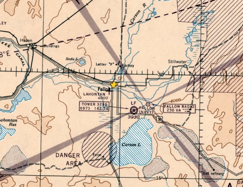
39.58, -119.204 (East of Reno, NV)
Fernley Airfield, as depicted on the 1985 USGS topo map.
Not much is known about this small airfield, including its name or purpose.
The airfield on the south side of Fernley was evidently established at some point between 1965-85,
as it was not yet depicted on a 1955 aerial photo nor on Sectional Charts from 1961/65/71/89/93/97.
The earliest depiction which has been located of Fernley Airfield was on the 1985 USGS topo map,
which depicted a single unpaved east/west runway, labeled as “Gravel landing strip”.
A small building was depicted on the northeast side, and another on the northeast side.
Fernley pilot Ted March reported, “Fernley Airfield... I have been told it was originally part of the gas line project in the late 1950s - early 1960s.
I remember the large Southwest Gas crews bringing in the pipeline. My guess is that the airstrip could have been used by survey operations, among other things.”
The earliest photo which has been located of Fernley Airfield was a 1994 USGS aerial view looking southwest.
It depicted the airfield as a single unpaved east/west runway, with one small hangar & the foundation of a former T-hangar on the northeast side,
and a small hangar on the northwest side.
A 2015 aerial view looking southwest at Fernley Airfield shows the hangar on the northeast side was removed at some point between 1994-2015,
but the other hangar remained on the northwest side.
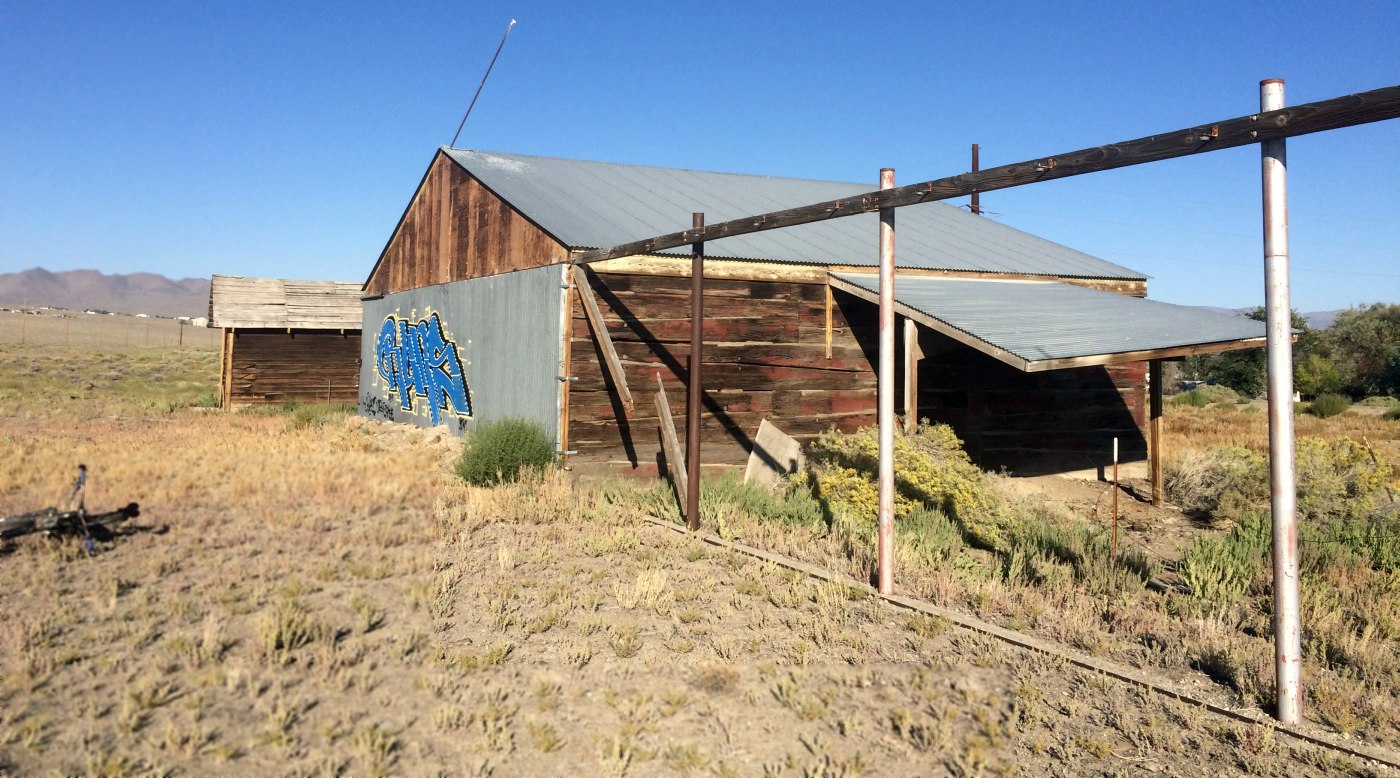
A 9/4/15 photo by Ken Nussear looking northwest at Fernley Airfield of “what appears to be a hangar constructed from railroad ties - with an outbuilding on the west end.
There are some old foundations on the east end. The runway is gravel & about 3,750', still landable by a small plane. It is within a few feet of the Truckee Canal,”
Fernley pilot Ted March reported in 2019, “Fernley Airfield... In recent years the field has been used by people for ultralight craft.
It is not useable by general aviation anymore due to power lines.”
The site of Fernley Airfield is located north of the intersection of Simons Road & Desert Shadows Lane.
Thanks to Ken Nussear for pointing out this airfield.
____________________________________________________
39.459, -118.786 (East of Reno, NV)
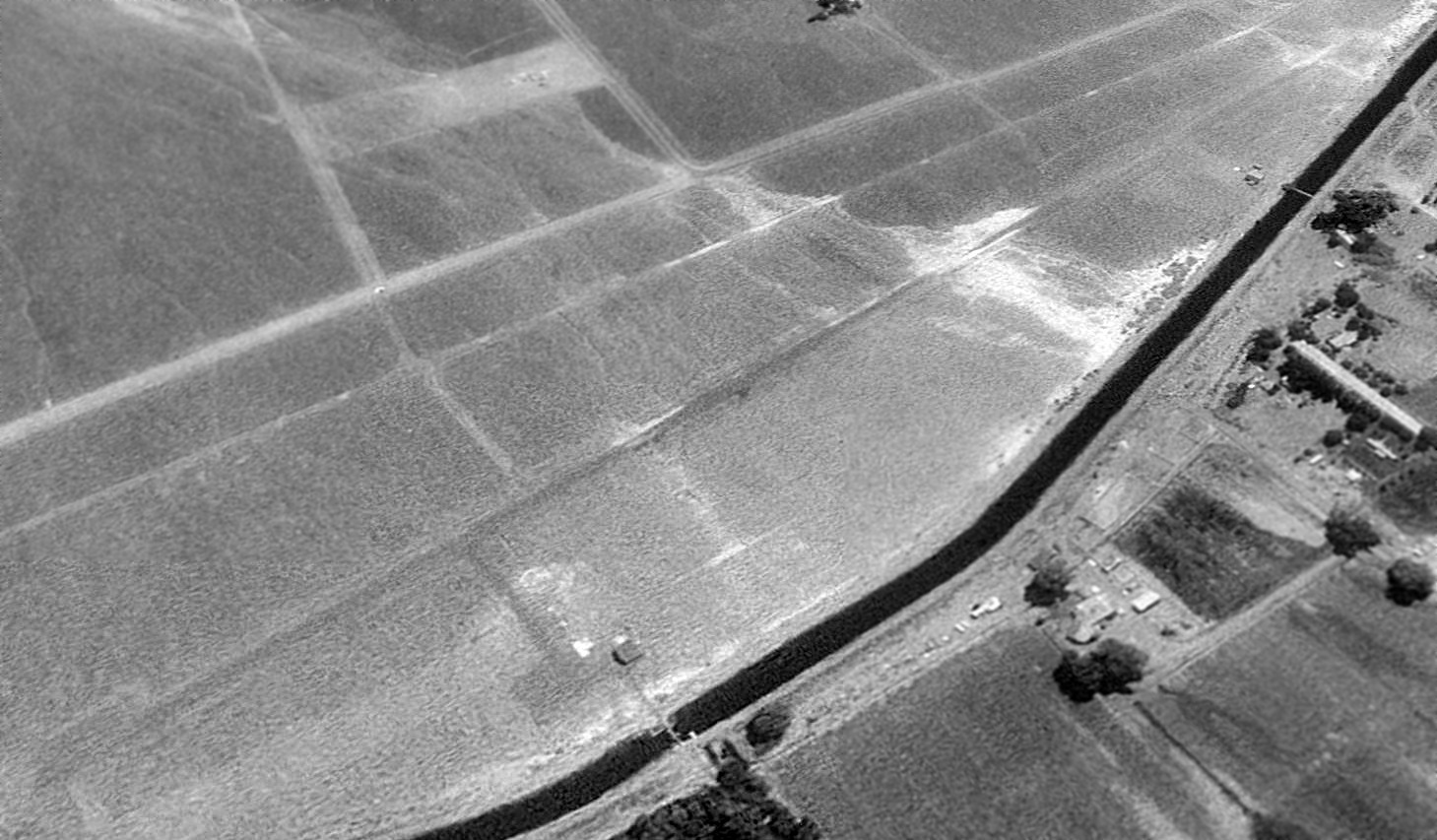
Lahontan Field, as depicted on the May 1945 Reno Sectional Chart.
This small general aviation airport on the southwest side of Fallon was evidently established at some point between 1944-45,
as it was not yet depicted on the October 1944 Reno Sectional Chart
nor listed among active airfields in the 1945 AAF Airfield Directory (courtesy of Scott Murdock).
The earliest depiction which has been located of Lahontan Field was on the May 1945 Reno Sectional Chart.
It depicted Lahontan as an auxiliary airfield.
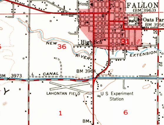
The earliest topo map depiction which has been located of Lahontan Field was on the 1951 USGS topo map (courtesy of Kevin Walsh).
It depicted Lahontan Field as having 2 runways in an X-shape, with a few small buildings along the periphery.
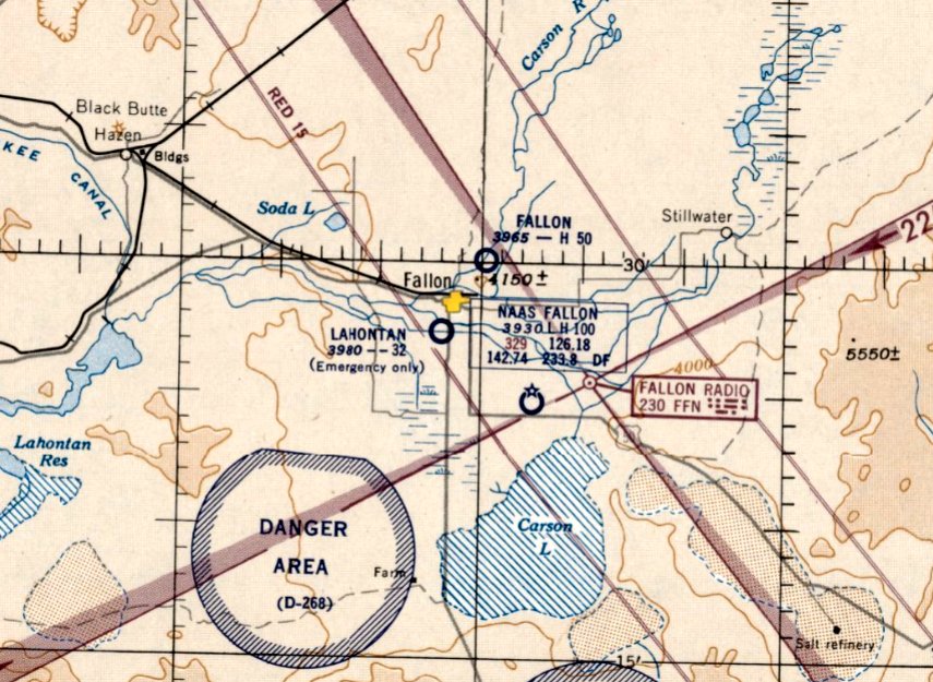
The last aeronautical chart depiction which has been located of Lahontan Field was on the May 1954 Reno Sectional Chart.
It depicted Lahontan as having a 3,200' unpaved runway,
but also indicated that it was suitable for “Emergency only”, which evidently foreshadowed the airport's impending closure.
Lahontan Field was evidently closed at some point in 1954,
as it was no longer depicted on the September 1954 Reno Sectional Chart.
It was presumably replaced by the larger Fallon Municipal Airport which had opened to the northeast.
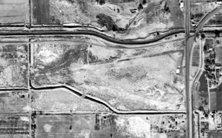
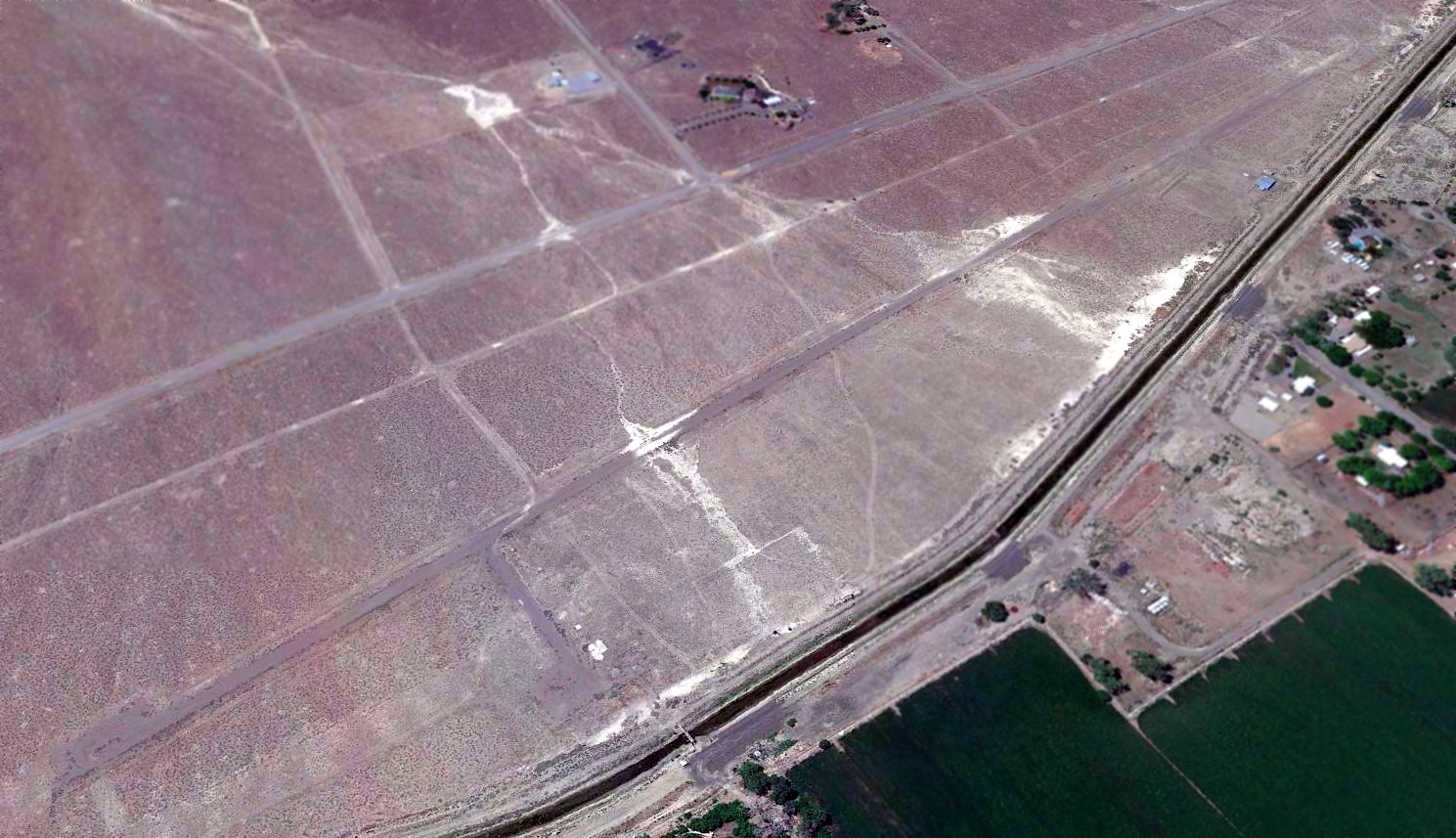
The earliest photo which has been located of Lahontan Field was an 11/25/56 USGS aerial view.
It depicted Lahontan Field as having an unpaved northeast/southwest runway, with a small building on the east side.
There were no aircraft visible, as it was evidently already closed by this point.
The last depiction which has been located of Lahontan Field was on the 1975 USGS topo map, which still depicted it as having 2 runways.
However it had evidently already been closed for more than 2 decades by that point.
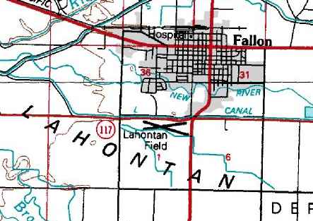
A 1994 aerial photo showed a park with athletic fields covering the site of Lahontan Field.
A 2014 aerial view showed no trace remaining of Lahontan Field.
As of 2016, street maps labeled the site of Lahontan Field as Churchill County Regional Park.
The site of Lahontan Field is located southwest of the intersection of Route 95 & Route 117.
Thanks to Kevin Walsh for pointing out this airfield.
____________________________________________________
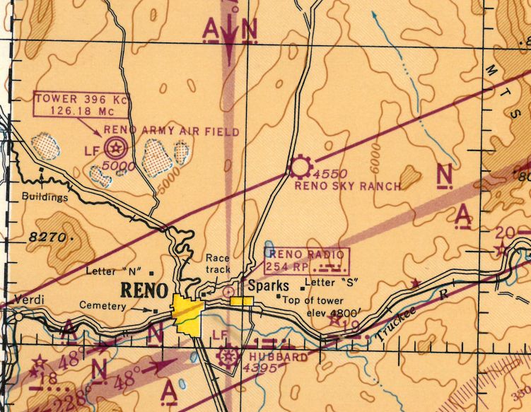
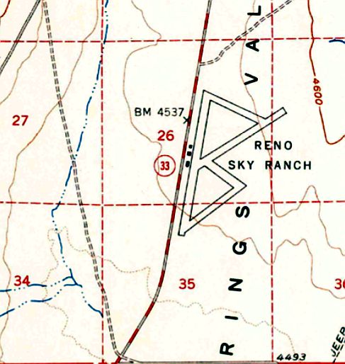
(Original) Reno Sky Ranch, Sparks, NV
39.65, -119.7 (Northeast of Reno, NV)
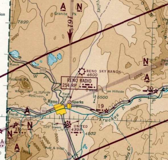
Reno Sky Ranch, as depicted on the July 1942 Reno Sectional Chart.
Reno Sky Ranch was “originally graded in the 1930s”, according to Keith Wood.
According to Wikipedia, the original Reno Sky Ranch began operation in the 1930s.
However, Reno Sky Ranch was not yet depicted on Reno Sectional Charts from 1935 through January 1942.
According to Keith Wood, Sky Ranch “was used by local ranchers until the beginning of WWII.
During the war, it was used for primary & intermediate flight training of Navy & Army pilots.
It also supported Sutcliffe NOLF & Pyramid Lake seaplane operations.
Naval aviators would drive to Sky Ranch, then fly up to Sutcliffe, thus saving what was then an hour (each way) of driving on dirt road.
The Navy believed that a pilot who could operate flying boats from a lake more than 4,600' up wouldn't have much problem anywhere else.”
Ginny Heck Gottfredson recalled, “My Father (R. C. Johnny Heck) was a flight instructor at the Reno Sky Ranch for the US Army Air Corps.
I have aerial photos he took of the airfield, buildings & some of the aircraft & other photos taken at ground level.
Flight logs reflect his first flight at the Sky Ranch was 5/30/42, and last flight 12/2/45.
Vernon Penrose another flight instructor was a close friend.”
His aerial photo depicted Reno Sky Ranch as having 4 short dirt runways, with a row of small buildings along the road on the west side.
The earliest depiction which has been located of Reno Sky Ranch was on the July 1942 Reno Sectional Chart.
It depicted Reno Sky Ranch as a municipal/commercial airport.
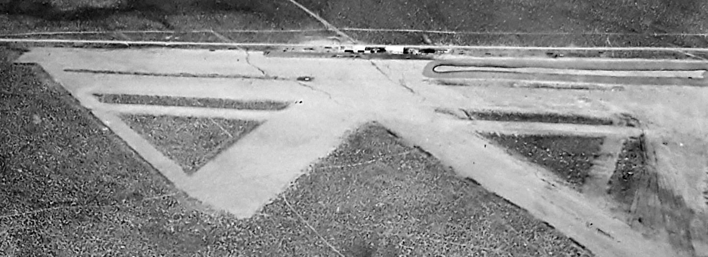
A circa 5/30/42-12/2/45 aerial view by R. C. Johnny Heck looking northwest at Reno Sky Ranch (courtesy of Ginny Heck Gottfredson).
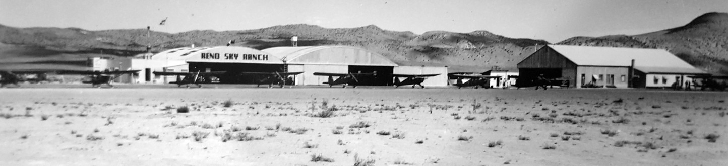
A circa 5/30/42-12/2/45 photo by R. C. Johnny Heck showing 9 light single-engine aircraft in front of hangars at Reno Sky Ranch (courtesy of Ginny Heck Gottfredson).
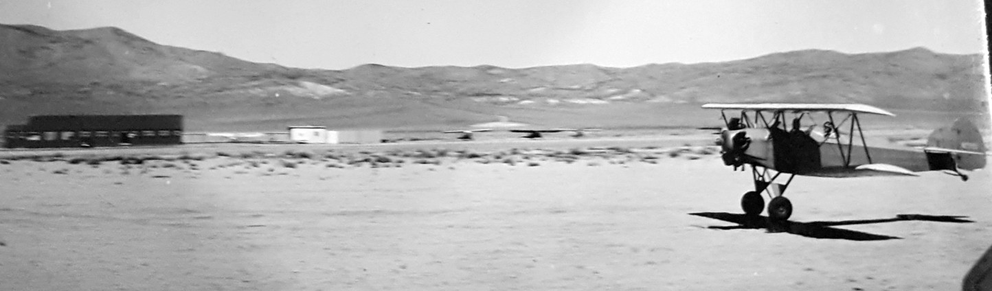
A circa 5/30/42-12/2/45 photo by R. C. Johnny Heck of a Fleet Model 7 biplane flying from Reno Sky Ranch (courtesy of Ginny Heck Gottfredson).
An 11/26/43 US Navy aerial view looking north at the original Reno Sky Ranch (from the National Archives, via Brian Rehwinkel).
It depicted the field as having 4 short dirt runways, with a row of small buildings along the road on the west side.
A closeup from the 11/26/43 US Navy aerial view of Reno Sky Ranch (from the National Archives, via Brian Rehwinkel),
showing at least 8 light aircraft along the west side of the field.
The March 1944 Reno Sectional Chart (courtesy of Tim Zukas) depicted Reno Sky Ranch as a commercial airfield.
According to Keith Wood, “After the war, Sky Ranch reverted to private use.”
Sky Ranch was not yet depicted on the 1948 USGS topo map.
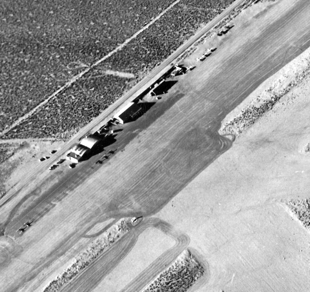
A 9/4/54 USGS aerial photo depicted the original Reno Sky Ranch as having 4 short dirt runways, with a row of small buildings along the road on the west side.
There were no aircraft visible on the field.
According to Keith Wood, “In the late 1950s, North American Aviation's Rocketdyne Division put their Nevada Field Laboratory on 126 square miles of empty land.
Sky Ranch was at the southwest corner of the Nevada Field Laboratory, and, being convenient, Rocketdyne made some improvements to the field
in exchange for being able to use it in support of their testing programs for the engines used in Gemini, Apollo, the Space Shuttle and various missiles.
During tests of the massive F-1 Apollo booster engine, the roar of 1.5 million pounds of thrust could be easily heard in Reno's casinos, over 20 miles away.”
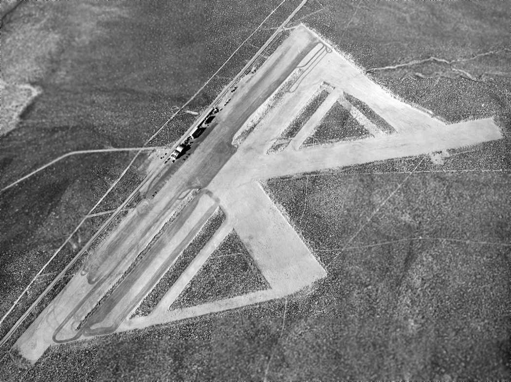
The earliest topo map depictions which has been located of Reno Sky Ranch was on the 1957 USGS topo map,
which depicted it as having 4 or 5 runways, with 3 small buildings on the west side.
The last aeronautical chart depiction which has been located of Reno Sky Ranch was on the September 1957 Reno Sectional Chart.
It depicted Reno Sky Ranch as having a 5,000' unpaved runway.
Reno Sky Ranch was not depicted on the September 1958 Reno Sectional Chart.
According to Wikipedia, the first Reno air race, was organized in 1964 by World War II veteran Bill Stead,
and held at Reno Sky Ranch airfield, a 2,000' dirt strip.
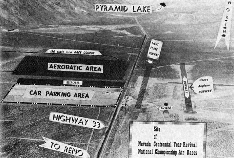
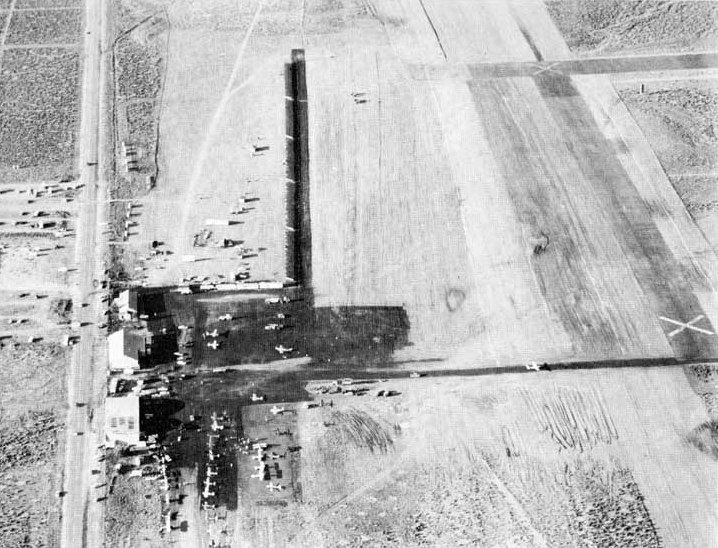
An undated aerial view looking north at the site of the original 1964-65 Reno Air Race course
showed a “light plane runway”, tower, and “heavy airplane runway”
superimposed over the distinctive pattern of the multiple runways (still evident) of Reno Sky Ranch.
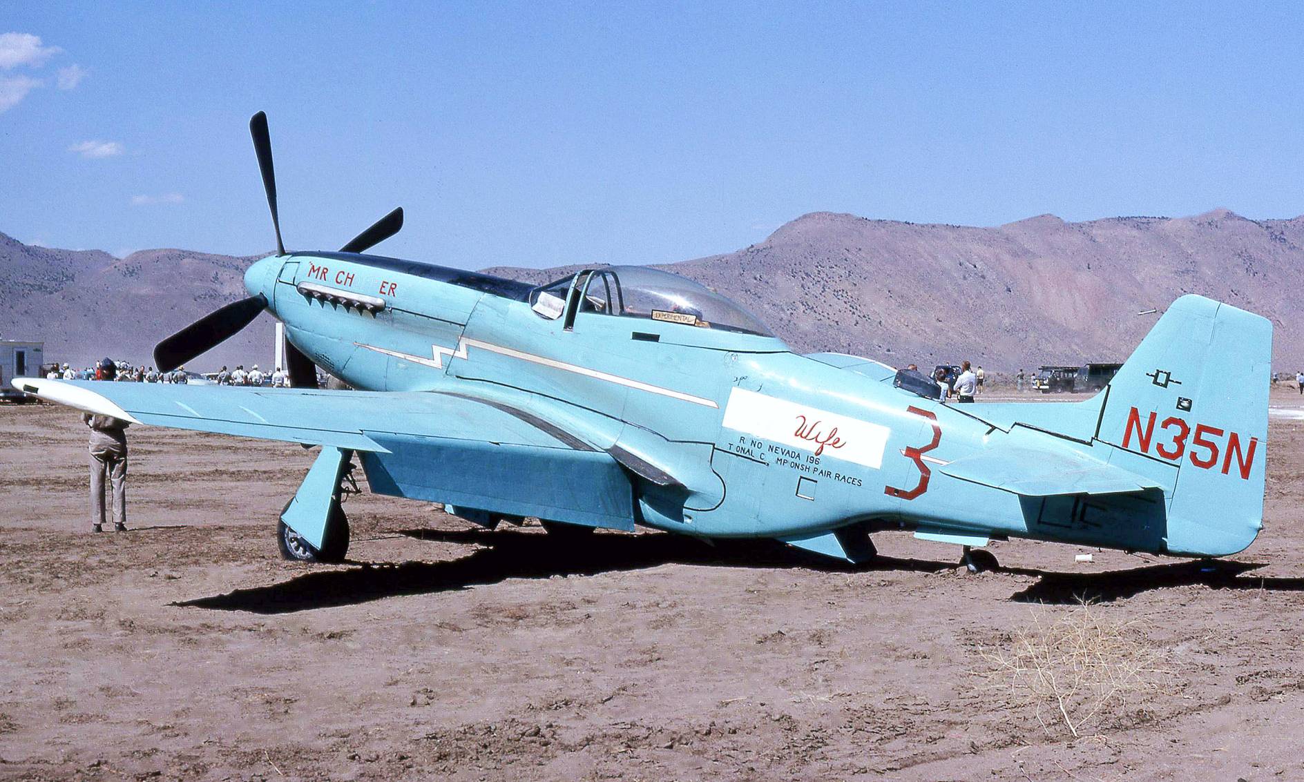
A September 1964 photo by Don Garrett (courtesy of Jay Sherlock) of North American P-51D Mustang “Mr. Chopper” N35N at the Reno Air Race at Reno Sky Ranch.
A Race Week 1965 aerial view looking northeast at the race aircraft gathered at Reno Sky Ranch.
According to Wikipedia, the 2nd Reno air race was held at Reno Sky Ranch in 1965.
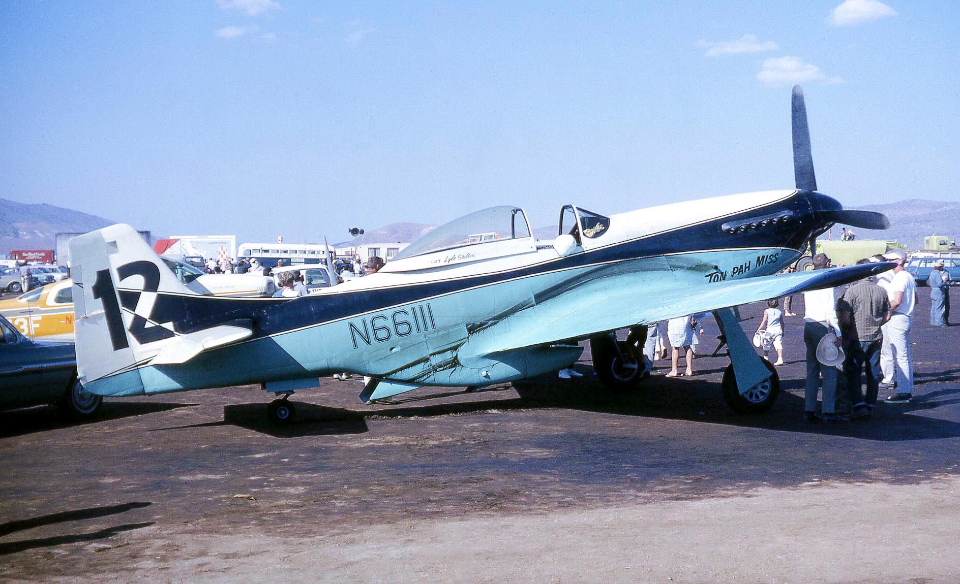
The last photo which has been located of Reno Sky Ranch was a September 1965 photo by Don Garrett (courtesy of Jay Sherlock) of North American P-51K Mustang “Tonopah Miss” N66111 at the Reno Air Race.
According to Wikipedia, in 1966 the Reno air race was relocated to the much larger Stead AFB after it was closed by the military & made available for civilian reuse.
According to Wikipedia, the original Reno Sky Ranch ceased operation in 1970.
However, the 1975 USGS topo map continued to depict the Reno Sky Ranch in an unchanged fashion.
A 1980 aerial view showed traces of the Reno Sky Ranch runways remained, along with the hangar foundations along the west side.
Reno Sky Ranch was no longer depicted on the 1980 USGS topo map or the April 1989 San Francisco Sectional Chart (courtesy of Kevin Walsh).
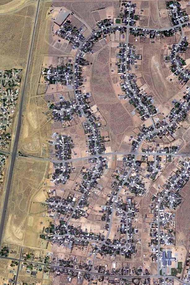
A 1994 USGS aerial view showed no trace remaining of Reno Sky Ranch, with the property covered by streets & houses.
A 6/1/13 aerial view showed no trace remaining of Reno Sky Ranch.
Keith Wood reported in 2014, “Traces of Sky Ranch can still be found, including chunks of the old paved runway & tiedown anchors.”
The site of Reno Sky Ranch is located northeast of the intersection of Pyramid Way & East Sky Ranch Boulevard.
Thanks to Michael McMurtrey for pointing out this airfield.
____________________________________________________
Reno Air Mail Field / Blanchfield Field / Blanch Field, Reno, NV
39.5, -119.81 (West of Reno International Airport)
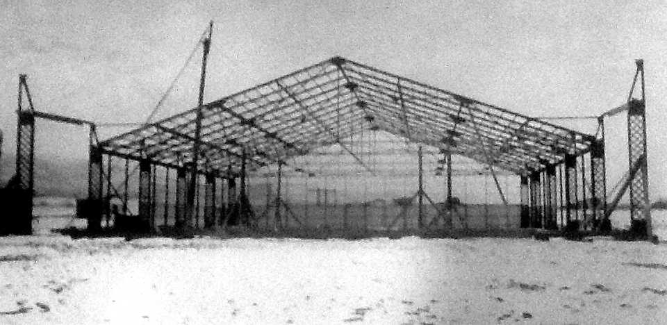
A late winter 1921 photo (courtesy of Neal Cobb) of the steel frame of the Reno Air Mail Field hangar under construction.
Curtis Carroll reported, “There was a 'Municipal Flying Field' at [this] site as early as 1918.
However, [it was] an unimproved facility with no services & existed for exhibitions, hobbyists
and a place for early California aviators, testing themselves & their ships over the Sierra, to refuel & turn around.”
Curtis continued, “The Reno Air Mail Field was the one of 14 airfields specially built for transcontinental air mail service that was launched in September, 1920.
Prior to its existence, Reno & Washoe County partnered to operate the new field located along Plumas Street 2 miles south of downtown Reno near the newly formed Reno Golf Club.”
An 8/9/20 article in the Reno Evening Gazette (courtesy of Curtis Carroll) chronicled the improvements needed to prepare for the milestone event:
“Work of improving the aviation field was begun yesterday in earnest with the arrival at the ground of material for hangars, storehouse, shed, etc.
A car load of 18 inch redwood, iron-bound pipe has been ordered for use in covering ditches at present blocking runways.
Two runways are to be constructed, each 100' wide & 1,000' long.
The surface will be smoothed & rolled to give the best possible start to airplanes taking-off. Each will have a gravel surface.”
Curtis Carroll reported, “The last leg of the transcontinental route, Omaha to San Francisco, was inaugurated on 9/8/20.
The initial westbound trip was made at the rate of 80 MPH & was flown without a forced landing, either for weather or mechanical trouble.
The first scheduled mail-plane landed in Reno on September 9 [1920].”
The earliest photo which has been located of the Reno Air Mail Field was a late winter 1921 photo (courtesy of Neal Cobb) of the steel frame of its hangar under construction.
According to Curtis Carroll, “Advanced construction techniques & materials were used including asbestos concrete panels for fireproofing and highly translucent wire glass for illumination.
The hangar was featured in the July, 1921 edition of Popular Mechanics magazine.
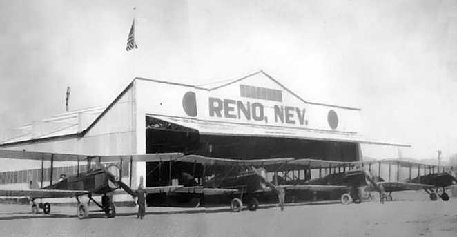
An early 1920s photo of Reno’s hangar & fleet of DH-4s (courtesy of Curtis Carroll).
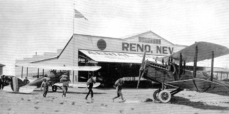
An early 1920s photo of an air mail plane transfer at Reno (courtesy of Curtis Carroll).
Curtis Carroll observed, “This is most likely posed for publicity purposes.
In an actual setting, the plane about to leave would have its engine running & the loading would be from the behind the wing.”
In early 1921, official instructions (courtesy of Curtis Carroll) were written for pilots landing & taking-off at each field along the transcontinental route:
“The air mail field at Reno lies 2 miles south of the city. The main runway is east & west.
The field is marked by a T & wind indicator, and landing from 4 ways is unobstructed. Reno is 4,497' above sea level.
Whenever possible it is advisable to leave the Reno field on the east-west runway, taking off to the east.
A slight downgrade enables the ship to quickly obtain flying speed.
Just beyond the east edge of the field the ground is extremely rough & there is a huge ditch here.”
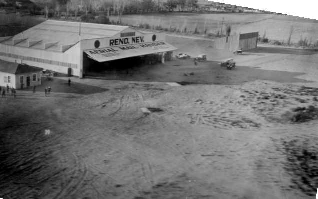
An early 1920s aerial view looking northeast at the Reno Airmail hangar (courtesy of Curtis Carroll).
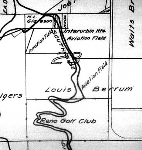
A 1921 T. K. Stewart parcel map (courtesy of Kim Henrick & the NV Historical Society) showed the land area used by & configuration of the “Interurbin Hts. Aviation Field”,
bordered on the east by Plumas Street & south by the fenced golf club.
The Southside Ditch, mentioned in the newspaper article & instructions, is also shown.
Curtis Carroll reported, “On 8/1/24, 29 year-old air mail pilot William Blanchfield, who usually flew the Reno to Elko segment,
was killed when his DH-4 hit a air pocket & stalled as he tried to circle Knights of Pythias cemetery to drop a wreath on the grave of an air mail service mechanic.
Shortly afterward, the airport was renamed Blanchfield in his honor.
I was told that the name was officially 'Blanchfield Field' but shortly evolved into 'Blanch Field'.”
Curtis Carroll reported, “Charles Lindbergh landed at Blanch Field on 9/20/27 with the Spirit of St Louis as part of national promotional tour,
the plane coming to a stop feet from parked cars & a stone fence.”
“Unless enlarged, this will never do for a commercial airport," Lindbergh told a group of reporters.
"The Reno field is entirely too small for planes the type of which will be seen in the near future.
It must be enlarged to take care of the gigantic airlines which are bound to come," he said adding that the runways needed to be at least 2,500' long.
Curtis Carroll reported, “In 1928, compelled in part by Lindbergh’s criticisms, Boeing purchased 120 acres at the current [Reno Airport] site
about 2.5 miles east of Blanch Field & opened Hubbard Field, named after Eddie Hubbard, the company's vice president of operations.
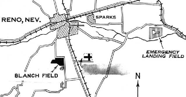
An early 1929 map (courtesy of Michael Maher & the NV Historical Society) showed the orientation of Blanch Field southwest of Reno
along with the new airport (to the southeast) & an Emergency Landing Field further east.
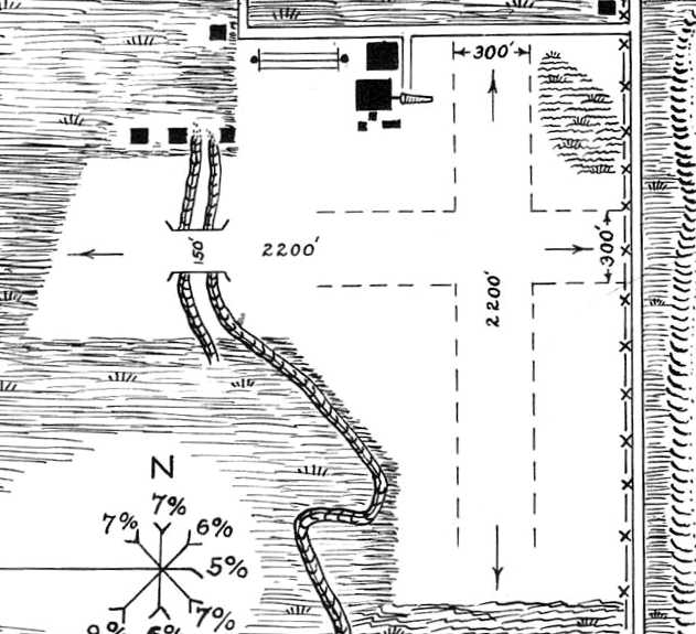
A 1929 Commerce Department Airway Bulletin (courtesy of Michael Maher & the NV Historical Society)
depicted Blanch Field as having 2 perpendicular 2,200' unpaved runways oriented north/south & east/west,
along with several hangars on the northwest side.
Curtis Carroll observed, “Note the east/west runway passing over the Southside Ditch mentioned in the early newspaper article
and the ditch past the east end of the runway referenced in the pilot’s instructions.”
According to Curtis Carroll, “Once operations began at Hubbard Field, Blanch Field quietly began to fade.
In 1933, Washoe County Commissioners decided to deed their half-ownership of the field to the city of Reno at no charge
and by 1935, the entire area had become the Washoe County Golf Course.”
Blanch Field was no longer depicted on the December 1935 Reno Sectional Chart.
A 6/5/11 aerial view showed no trace remaining of Reno Blanch Field.
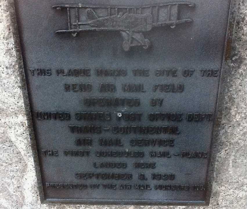
A December 2012 photo by Curtis Carroll of the historical plaque marking the site of the airfield placed by the Air Mail Pioneers.
It is located south of the tennis court parking lot on Plumas Street, near the site of the east end of the east/west runway.
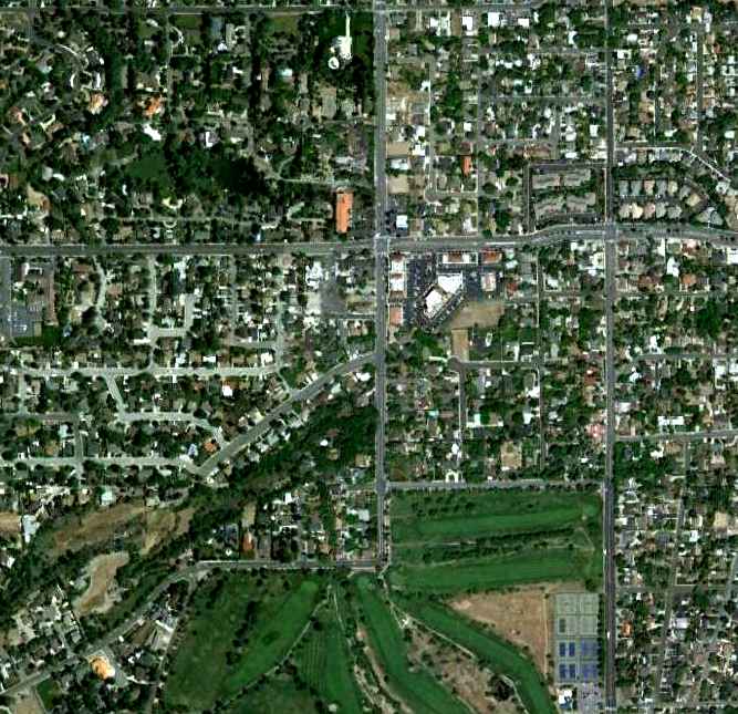
The site of Reno Blanch Field is located southwest of the intersection of Plumas Street & Urban Road.
____________________________________________________
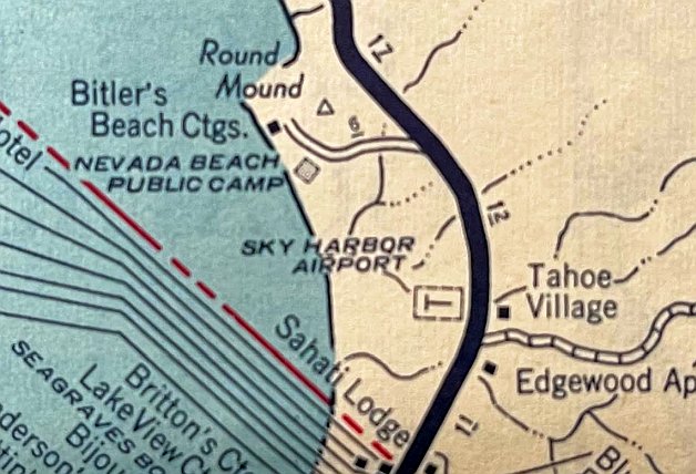
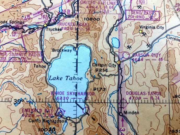
Tahoe Sky-Harbor Airport, Stateline, NV
38.97, -119.94 (Northeast of Lake Tahoe, CA)
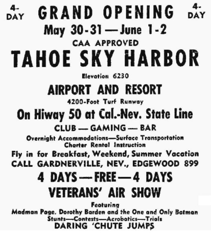
A poster promoting the May 30 (year unknown) Grand Opening of Tahoe Sky Harbor Airport & Resort (courtesy of Scott Levy).
No airfield was yet depicted at this location on a 1940 aerial photo.
Tahoe Sky-Harbor Airport was not yet depicted on the May 1945 Reno Sectional Chart.
According to the Community Watershed Partnership, “During the late 1940s,
Burke Creek was relocated & the western portion of the meadow filled to develop the first airport in the Tahoe Basin.”
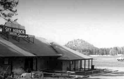
According to a plaque on the airport site (courtesy of David Karlsberg), "During the late 1940s, this land was used by Sky Harbor Airport & Casino,
which flew its wealthy patrons in from San Francisco to spend money in the local casinos.
The airport consisted of a dirt landing strip, but with the snow-crested Crystal Range gleaming in the background, if offered great views.
Unfortunately, flying in and out was dangerous because of high winds & a steep descent.”
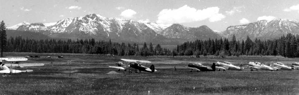
The earliest depiction which has been located of Sky-Harbor Airport was a 1946 photo
showing a large number of general aviation aircraft next to a grass runway, including a number of military surplus T-6 Texans.
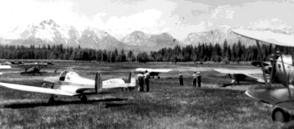
A 1946 photo of an Ercoupe & several other general aviation aircraft at Sky-Harbor Airport.
A 1946 photo of the Sky Harbor Casino, with Round Hill in the background, and what appears to be a Lockheed Electra on the right side (courtesy of Scott Levy).
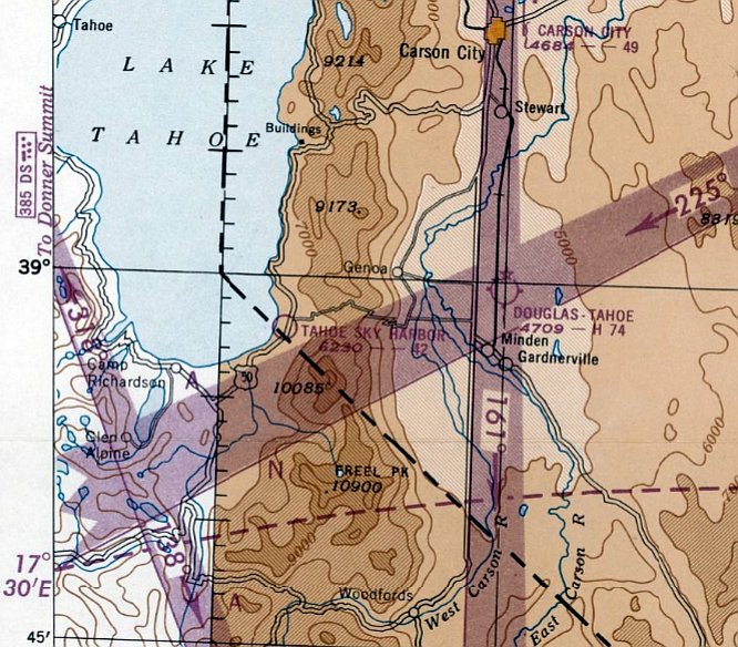
The earliest aeronautical chart depiction which has been located of Tahoe Sky-Harbor Airport was on the February 1947 Reno Sectional Chart.
It depicted Tahoe Sky-Harbor Airport as having a 4,200' unpaved runway.
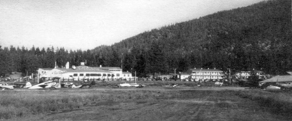
A 1940s photo of a variety of general aviation aircraft at Sky-Harbor Airport (courtesy of Kevin Walsh).
A circa late 1940s aerial view looking along the single unpaved runway at Sky-Harbor Airport.
According to the Community Watershed Partnership, “The Sky Harbor Airport was shut down before 1950.”
However this appears to be contradicted by the airport persisting on aeronautical charts after that.
A 1950/51 road map (courtesy of Kevin Walsh) depicted Sky Harbor Airport as a rectangular property outline.
The last aeronautical chart depiction which is available of Tahoe Sky-Harbor Airport was on the May 1950 Salt Lake - San Francisco Flight Chart (courtesy of Kevin Walsh).
It depicted Tahoe Sky-Harbor Airport as having a 4,200' unpaved runway.
The last aeronautical chart depiction which has been located of Tahoe Sky-Harbor Airport was on the September 1951 Reno Sectional Chart.
Tahoe Sky-Harbor Airport was evidently closed at some point between 1951-52,
as it was no longer depicted on the March 1952 Reno Sectional Chart.
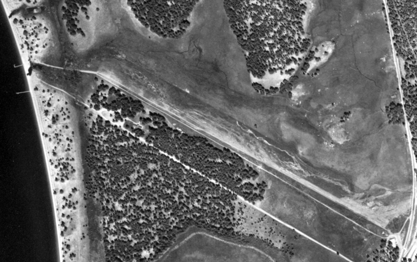
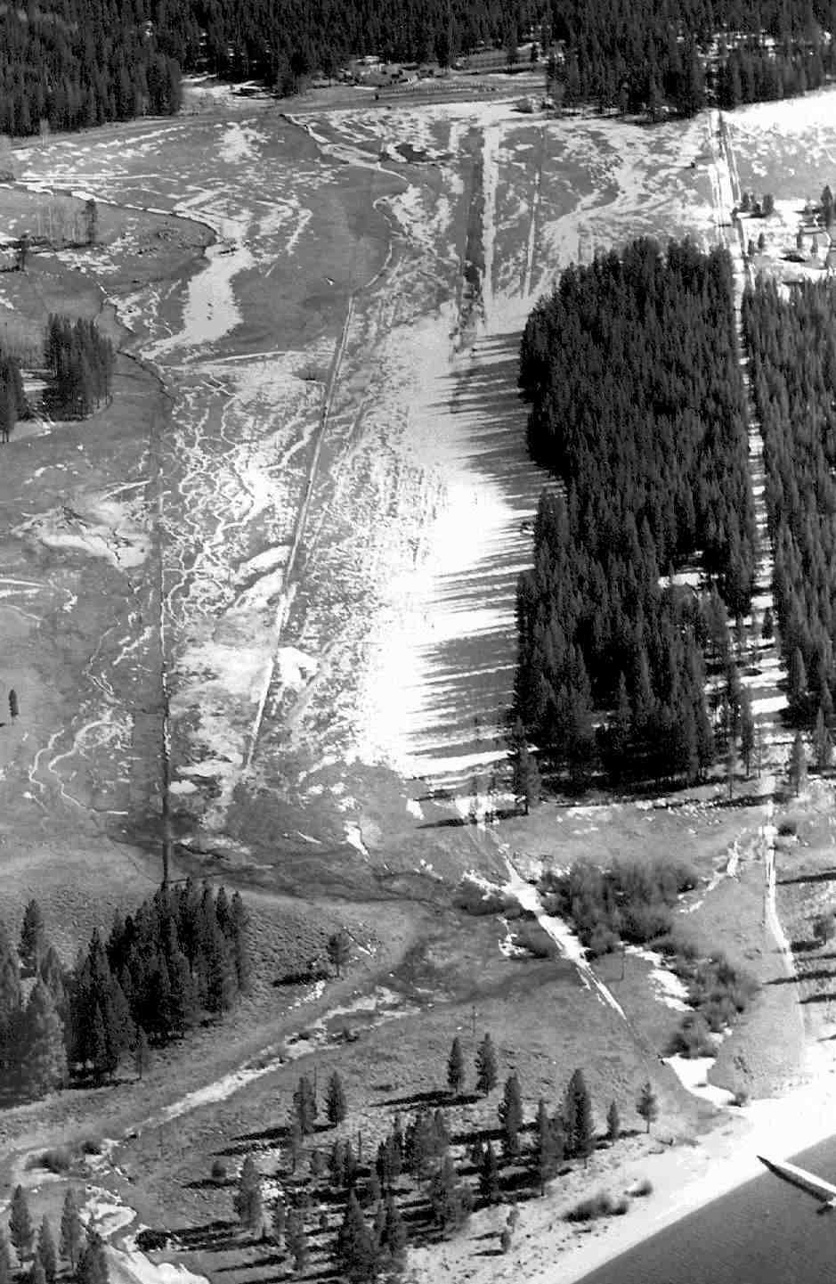
The last photo which has been located of Tahoe Sky-Harbor Airport was an 8/14/52 USGS aerial view (from the USCB Library).
It depicted Tahoe Sky-Harbor Airport as having a northwest/southeast runway.
One light single-engine plane appears to have been parked on the north side of the southeast runway end.
According to a plaque on the airport site (courtesy of David Karlsberg), "After Sky Harbor Airport closed Lake Tahoe was without an airport until 1958.”
No airfield-related features were depicted on the 1957 USGS topo map.
According to the Community Watershed Partnership, “The abandoned airstrip along Burke Creek was later developed as a residential neighborhood.”
A 1969 aerial photo showed that housing covered the site of Sky-Harbor Airport.
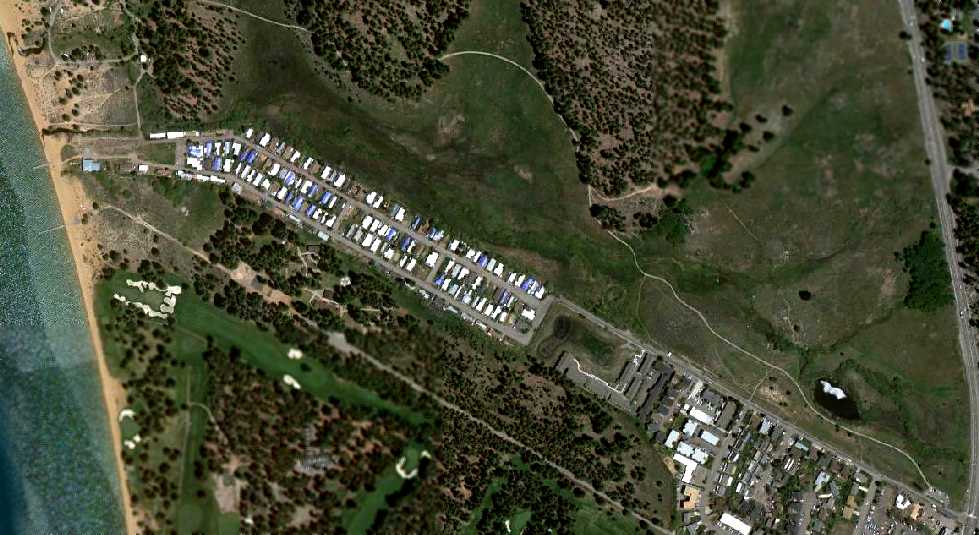
A 6/15/11 aerial view showed no trace remaining of Sky-Harbor Airport.
David Karlsberg reported in 2012, “Besides the plaque not a trace of the airport remains.”
The site of Sky-Harbor Airport is located northwest of the intersection of Route 50 & Kahle Drive.
____________________________________________________
Humboldt Intermediate Field, Humboldt, NV
40.086, -118.156 (Northeast of Reno, NV)
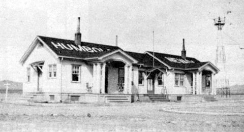
A 1929 photo of the Humboldt airway radio station building (courtesy of www.atchistory.org).
The Humboldt airfield was one of the network of Intermediate Fields
which was constructed by the Civil Aeronautics Administration in the 1920s & 1930s.
The Intermediate Fields were intended for the emergency use of commercial aircraft flying on airways between major cities.
The date of construction of the Humboldt Intermediate Field has not been determined.
The earliest depiction which has been located of the field
was a 1929 photo of the Humboldt airway radio station building (courtesy of www.atchistory.org).
The earliest map depiction which has been located of the Humboldt Intermediate Field
was an unnamed depiction on a 1930 Nevada Bureau of Mines map (according to Adam Knight).
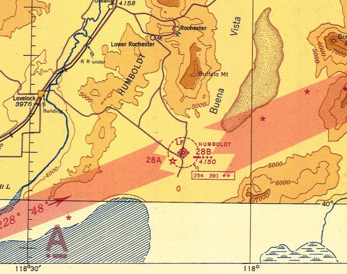
The Airport Directory Company's 1933 Airport Directory (courtesy of Chris Kennedy)
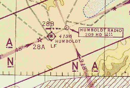
described Humboldt as the Department of Commerce's Intermediate Field Site 28B along the San Francisco - Salt Lake airway.
The landing area was said to consist of a triangular sod field, measuring 3,500' on each side,
which was equipped with a beacon, boundary, approach, and obstruction lights.
Describing the field as "sod" must have been quite optimistic - there probably wasn't much sod in the Nevada desert!
The earliest aeronautical chart depiction which has been located of Humboldt Intermediate Field
was on the January 1936 Elko Sectional Chart (courtesy of Roger Connor).
It depicted the Humboldt airfield as Commerce Department Site 28B.
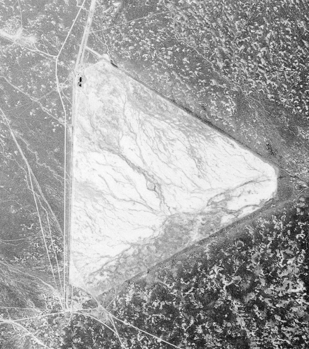
The earliest photo which has been located of the Humboldt Intermediate Field was an 8/21/41 USGS aerial view.
It depicted Humbolt to consist of a triangular unpaved airfield, with possibly 2 small buildings on the northwest corner.
The last chart depiction which has been located of Humboldt as an active airfield
was on the May 1945 Elko Sectional Chart (courtesy of Chris Kennedy).
It depicted the Humboldt airfield as Site 28B.
Being in a very remote area, the Humboldt airfield remained operational (at least nominally)
much longer than most of the other Intermediate Fields.
It apparently was closed at some point between 1945-48,
as it was no longer depicted on the November 1948 Elko Sectional Chart (according to Chris Kennedy).
The 1954 USGS topo map still depicted an “Airway Beacon”, but did not depict anything of the airfield itself.
Josh McNutt reported, “I inventoried the Humboldt Intermediate Field as part of an archaeological survey.
My research with the BLM found that the northern portion of the field was used as an unpermitted antimony mill that was built in the 1980s.
It is my suspicion that the original airfield structures were destroyed by the mining company.”
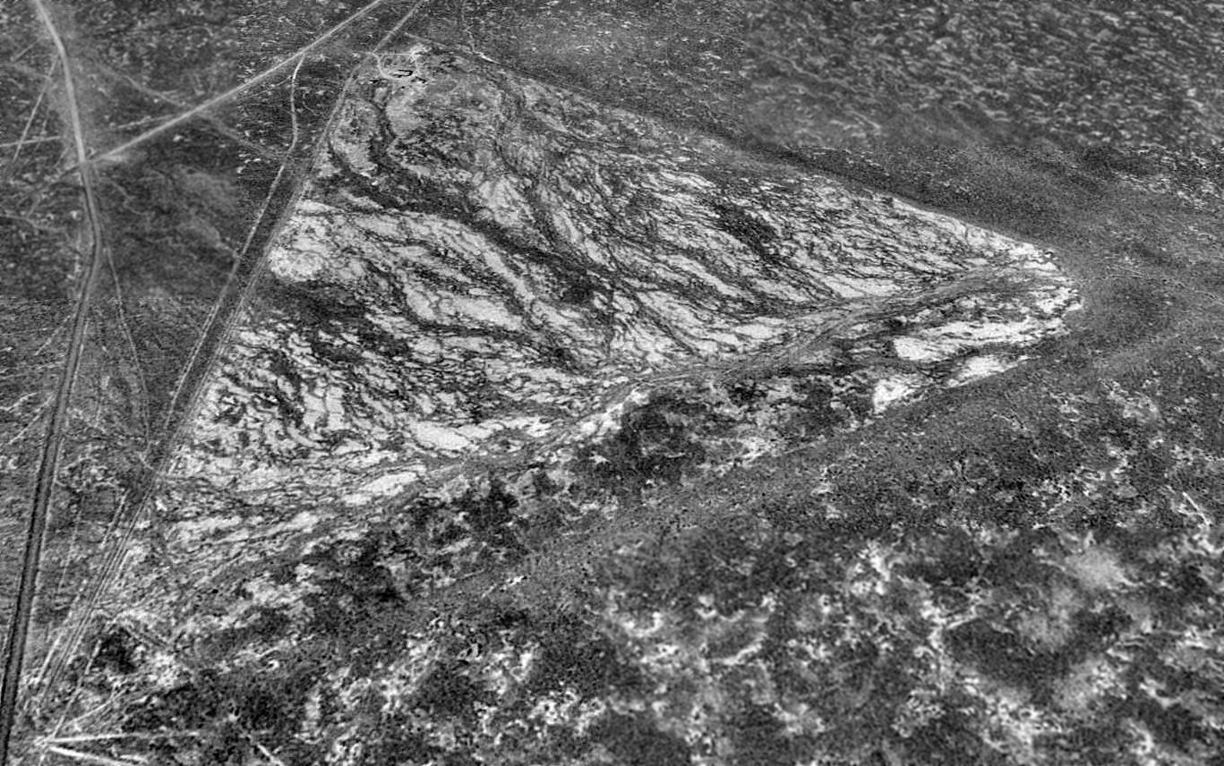
A 1994 USGS aerial view looking north showed the triangular layout of Humboldt Intermediate Field was still quite apparent more than 60 years after it was constructed.
A single building was visible on the northwest corner of the field.
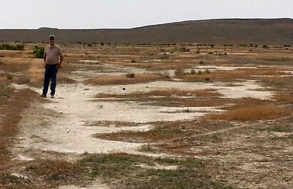
A 6/30/13 photo by Adam Knight of Dan Knight on the remains of Humboldt's south runway.
Adam reported, there is “not much to see on the ground level. I think that diversion ditches were dug just outside the runways.
These are still evident, but one must look hard to find the runways in most places.
Most of the runways have been displaced by brush, dune, or bubble-crust.
On the south corner, there is a gravel pit & evidence of a camp that was occupied by several people - probably during the winter months, as there is much klinker on the dump.
There are some garbage dumps & several heavy timbers, sunk into the the surface & arranged in parallel about 7' apart.
The pit is shallow, perhaps hand-dug or with very small machinery, perhaps 2,000 tons has been removed.
I wonder of it was a camp for the airfield construction crew.”
![]()
A 6/30/13 photo by Adam Knight of the foundation of the Humboldt “beacon on the hill 1/2 mile away with the airfield in the back ground.”
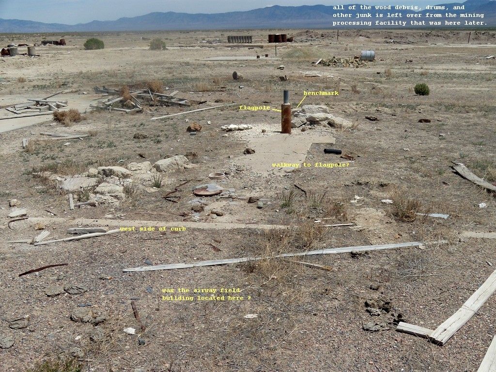
A 5/20/13 photo by Dick Simonsen of debris at the site of Humboldt Intermediate Field.
Dick reported, “I spent time at the site looking at the building & objects & excavations there,
and concluded that the area was occupied by some sort of mining-processing facility after the Intermediate Field was there.
The building was about 2 stories tall, not low & wide like hangars I have seen.
The floor is mostly dirt but had a partially concrete area which seems to be set up for some machinery, and there was a tall narrow door at one end.
Near the building area is an excavated pond area evidently for storing processing liquids & a hazardous dump site.
There are also several smaller concrete slabs in the area & some large tanks.
Over the years salvagers have claimed the metal parts of the building leaving only the foundation. Is there any evidence there of the old airfield?
Some evidence was found described in Benchmark Datasheet LS0212 which mentions in its description the 'Humboldt Intermediate Field'
and objects that were at at the Field site, namely a flagpole & a concrete curb. I found the benchmark & the objects.
[The photo above shows] the oval concrete curb, the cutoff flagpole, and a walkway from the flagpole to the west side of the curb.
The oval-shaped curb, flagpole & walkway are similar to like objects found at the Buffalo Valley Intermediate Field site southwest of Battle Mountain.
There is a building slab that was poured on top of the northern part of the curb which I believe is part of the later processing facility.”
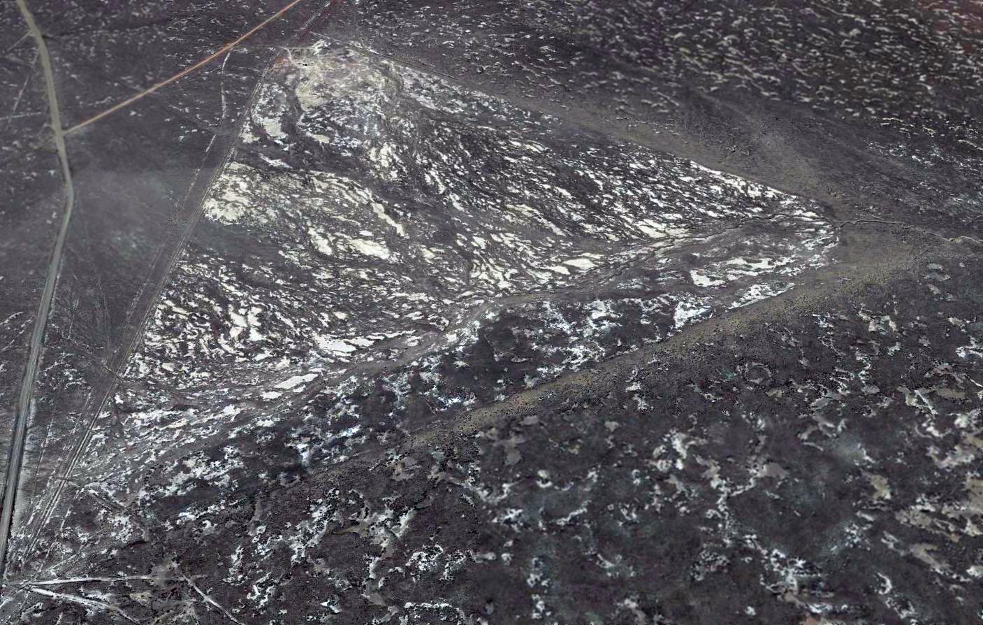
A 2014 aerial view looking north showed the remains of Humboldt Intermediate Field were still largely unchanged.
Josh McNutt reported in 2018, “Last fall [2017] I inventoried the Humboldt Intermediate Field as part of an archaeological survey.
Strangely I am the first to have officially recorded the site for the State.
The BLM stated that it partially removed what mining structures were present on the site as they were all heavily contaminated & very toxic.
As noted there are concrete pads built on top of the original [airfield] structure pads.
I found the only remaining original structure is the sawed-off flagpole & 1949 benchmark within the oval concrete area.
I wanted to warn any visitors to stay away from the mill area at the northern end.
My crew & I found out after the fact that it is considered a HazMat site by the BLM & the trash, barrels, tanks, pits, and tailings piles on that part of the site are highly toxic.
My crew & I experienced light-headedness after recording it for approximately 3 hours; who knows what sort of unperceived exposure we had.”
An 11/29/20 photo by Sean Crowley of the circular airport marker in the middle of Humboldt Intermediate Field.
The site of the Humboldt Intermediate Field is located in a very remote area, 15 miles southeast of Lovelock, NV.
____________________________________________________
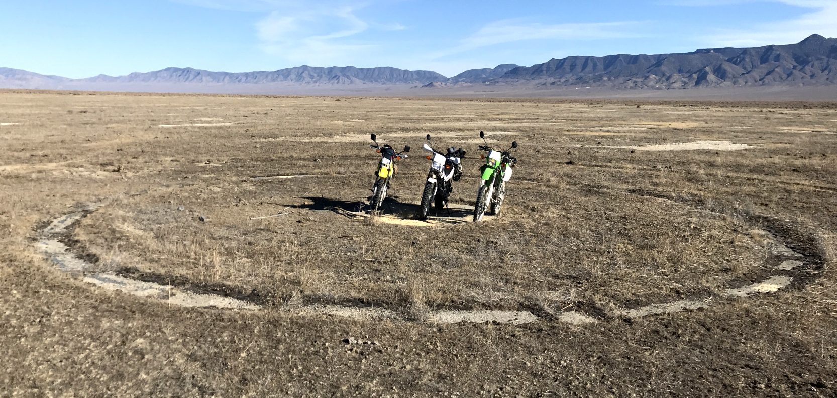
Sutcliffe Naval Outlying Landing Field / Sutcliffe Airport, Sutcliffe, NV
39.94, -119.6 (North of Reno, NV)
"Sutcliffe (Navy)", as depicted on the May 1946 Elko Sectional Chart.
Photo of the airfield while open has not been located.
Sutcliffe NOLF was built during WW2 as one of 5 satellite airfields for Fallon NAAS, which trained Navy Carrier Air Groups.
Sutcliffe was built to support torpedo, bombing, and strafing on the adjacent Pyramid Lake.
According to John Voss, "Waterborne mobile bombing targets operated north of Latitude 40 degrees North.
Permission to bomb, strafe and drop torpedoes into the lake had to be negotiated
through a lease with the Paiute Indian Tribal Council."
The date of construction of Sutcliffe has not been determined.
It was not depicted on the 1940 Airports & Airways Map from the NV Division of Aeronautics (courtesy of Jim Mallery),
listed among active airfields in the 1944 US Army/Navy Directory of Airfields (courtesy of Ken Mercer),
or depicted on the May 1945 Reno Sectional Chart.
The earliest depiction of the field which has been located was on the May 1946 Elko Sectional Chart,
which depicted "Sutcliffe (Navy)" as an auxiliary airfield.
Sutcliffe was apparently abandoned by the Navy at some point in 1946,
as it was no longer depicted on the November 1946 Elko Sectional Chart, or the 1957 USGS topo map.
Apparently, Sutcliffe was reopened as a civilian airport at some point between 1957-66,
as that is how it was depicted on the June 1966 Reno Sectional Chart (according to Chris Kennedy).
The Aerodromes table on the 1967 Reno Sectional Chart (courtesy of John Voss)
described Sutcliffe as having a single 2,200' gravel runway, with "Hazardous boulders on landing strip."
The Sutcliffe Airfield was evidently closed (for reasons unknown) at some point between 1967-71,
as it was no longer depicted on the November 1971 San Francisco Sectional Chart (courtesy of Ron Plante).
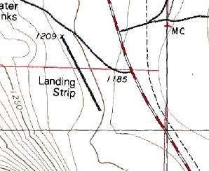
The 1980 USGS topo map depicted a single 1,800' runway, labeled simply as "Landing Strip",
which most likely indicated that Sutcliffe was closed by that point.
A 1994 USGS aerial view looking northeast at the site of Sutcliffe Airfield showed the barely-discernible trace of 2 runways.
A 2015 aerial view looking northeast at the site of Sutcliffe Airfield showed one runway outline was still prominent, but the 2nd runway outline was barely recognizable.
____________________________________________________
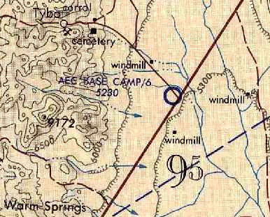
Basecamp Airfield, Warm Springs, NV
38.32, -116.28 (Northwest of Las Vegas, NV)
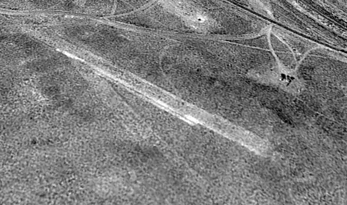
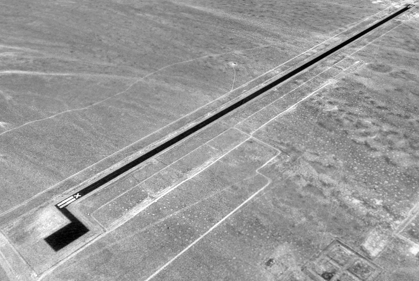
An 11/13/67 USGS aerial view of the Basecamp Airfield.
The Basecamp Airfield was evidently constructed by the Atomic Energy Commission,
which used it to support the base camp for the Project Faultless underground nuclear test to the north.
The Basecamp Airfield may have been built at some point between 1966-68,
as it was not depicted at all on the June 1966 Reno Sectional Chart (according to Chris Kennedy).
The earliest depiction of the Basecamp Airfield which has been located was an 11/13/67 USGS aerial photo.
It depicted a single northeast/southwest runway, with 2 closed-runway “X” symbols on each end, and an unpaved ramp area to the southeast.
Note that the area to the east of the ramp appeared to have been censored.
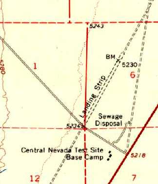
The 1968 USGS topo map depicted a single northeast/southwest unpaved runway, labeled “Landing Strip”.
The only buildings depicted were 3 small structures across the road to the south, labeled “Central NV Test Site Base Camp”.
After the end of Project Faultless in 1968, the Basecamp facility was abandoned by the DOE, and taken over by the Air Force, which built a modern 7,300' runway.
The Basecamp Airfield still was not depicted on the January 1969 Reno Sectional Chart.
The earliest aeronautical chart depiction which has been located of the Basecamp Airfield
was on the July 1970 Air Force Tactical Pilotage Chart (courtesy of Chris Kennedy).
It was labeled as "AEC Base Camp".
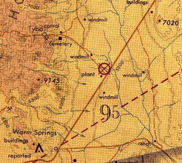
Curiously, only a single year later, the Basecamp Airfield was depicted as abandoned
on the 1971 Las Vegas Sectional Chart (courtesy of Vince Granato).
The Basecamp Airfield was still depicted as abandoned on the 1985 Las Vegas Sectional Chart.
It was labeled "Test Site Base Camp" on the 1990 NV Airports & Landing Strips Map (courtesy of Jim Mallery).
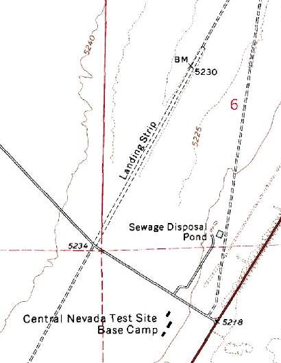
Curiously, the depiction of the Basecamp Airfield on the 1991 USGS topo map
was identical to how it had been depicted on the 1968 USGS topo map,
not reflecting any of the improvements made to the facility in the 33 subsequent years.
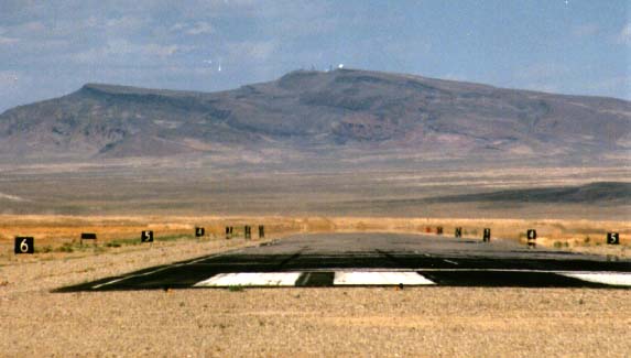
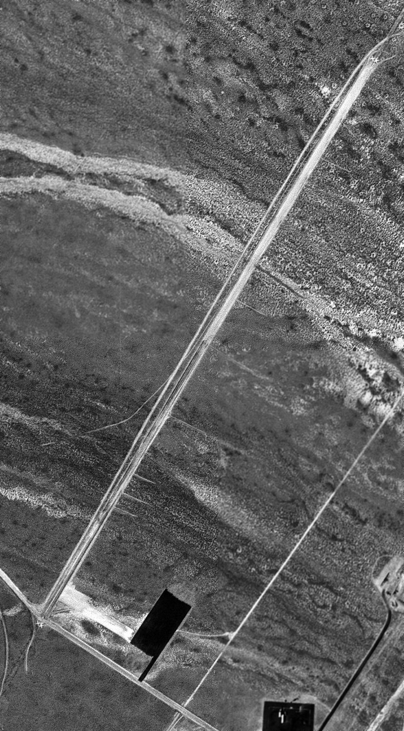
A late 1990s view looking northeast along the Basecamp Airfield runway.
Note the radar dome atop the mountain in the background, directly aligned along the runway centerline,
and the "thousands-remaining" signs along both sides of the runway.
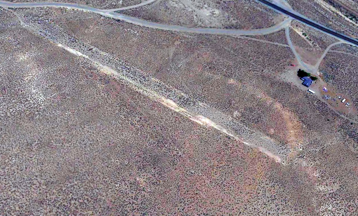
A 1999 USGS aerial view looking northwest at the Basecamp Airfield showed a runway that appeared to have been recently paved, yet was also marked with closed-runway "X" symbols.
An asphalt ramp at the south end of the runway appeared to be the only other aviation infrastructure at the site -
there did not appear to be any hangars or other buildings directly associated with airfield operations.
As it exists in the 2000s, the Basecamp Airfield is a "secret" facility in plain sight:
signs on the fence say only the "U.S. Government" owns the facility,
and personnel there will not divulge any further information.
Evidence indicates it is operated by a government contractor on behalf of
the Air Force Flight Test Center, probably in support of testing at Groom Lake.
The Basecamp runway, equipped with modern navigation aids
(including a TACAN/VOR/DME adjacent to the runway, frequency 113.9),
is still depicted as an abandoned airfield on recent aeronautical charts & has an "X" painted on each end of the runway.
Facilities for aircraft are minimal: a well-equipped fire station & many fire extinguishers positioned along the runway,
but no hangars or other places to store aircraft.
There appear to be no aircraft at all stationed at this facility.
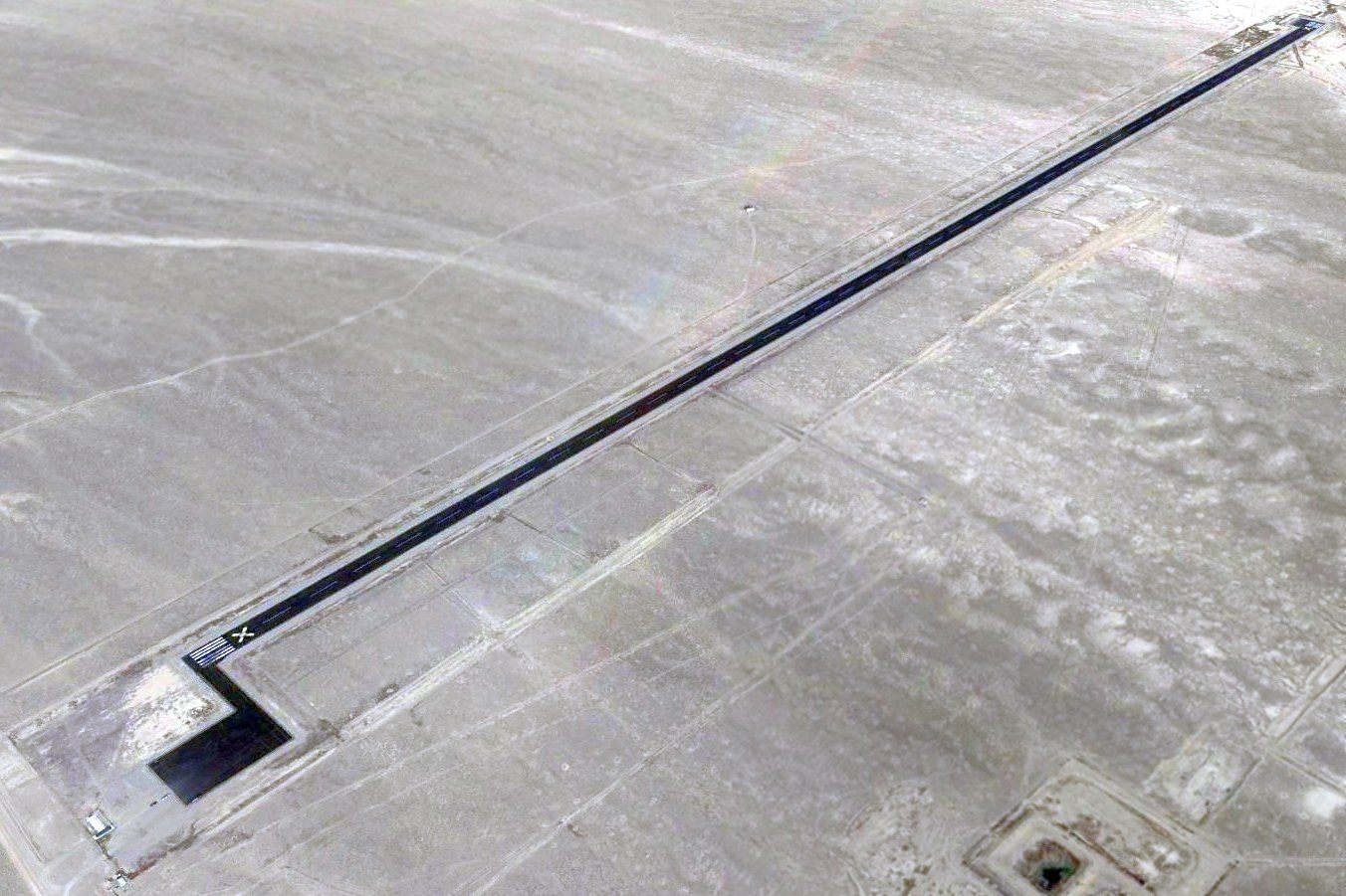
A 2014 aerial view looking northwest at Basecamp's runway, showing the closed-runway “X” symbols.
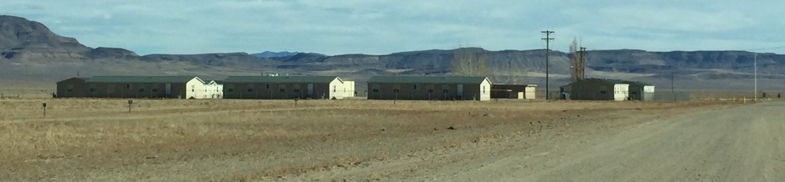
An 11/23/17 photo of the new buildings at Basecamp, built outside of the airfield fence.
An observer reported, “Nothing has changed about the runway & aviation facilities. There are no hangar facilities at the airport.
I drive by the airfield approximately 2-3 times a year. I have not seen an airplane on the runway or ramp one time over the last 7 years.
However the number of buildings continues to increase since 2010, particularly in the past 3 or so.
The new buildings are all outside the fence protecting the runway & ramp.
They appear to be classroom or meeting buildings. Some of them might be residential/dorm-style facilities.”
The Basecamp Airfield was still depicted as abandoned on the August 2020 Las Vegas Sectional Chart.
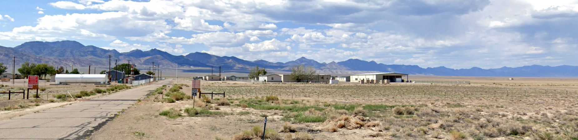
A 2022 photo looking west at the Basecamp Airfield.
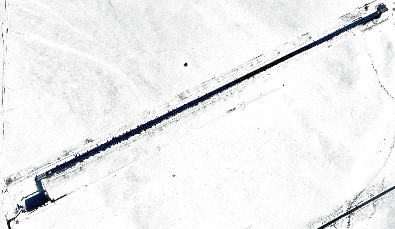
A 2023 aerial view looking northwest showed the Basecamp Airfield runway to still be painted with closed-runway “X” symbols, yet was neatly plowed of snow.
The Basecamp Airfield is located adjacent to Route 6 about 10 miles northeast of Warm Springs.
See also: http://www.ufomind.com/area51/orgs/basecamp/
____________________________________________________
Or if you prefer to contact me directly concerning a contribution (for a mailing address to send a check),
please contact me at: paulandterryfreeman@gmail.com
If you enjoy this web site, please support it with a financial contribution.
____________________________________________________
This site covers airfields in all 50 states.