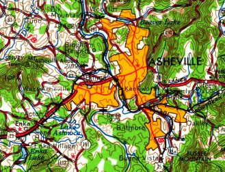
Abandoned & Little-Known Airfields:
Western North Carolina
© 2002, © 2025 by Paul Freeman. Revised 2/8/25.
This site covers airfields in all 50 states: Click here for the site's main menu.
____________________________________________________
Please consider a financial contribution to support the continued growth & operation of this site.
Asheville-Hendersonville Airport (revised 5/21/18) - Baird Bottom Landing Strip (added 10/12/14) - Brevard Airport (added 4/8/17)
Camp Summit Airfield (revised 3/12/16) - Carrier Field / Owens Field (revised 5/9/22) - Ferguson Landing Field (revised 9/15/20) - Fields of the Wood Airfield (revised 7/1/15)
Franklin Airport (revised 6/11/17) - Lake Logan Airfield (revised 6/11/17) - Josephson Airport / Emma Airport / Asheville Airpark (revised 2/8/25) – Wolf Ridge Airport / Skyline Peak Airport (revised 10/21/22)
____________________________________________________
Ferguson Landing Field, Bryson City, NC
35.44, -83.4 (Southwest of Asheville, NC)
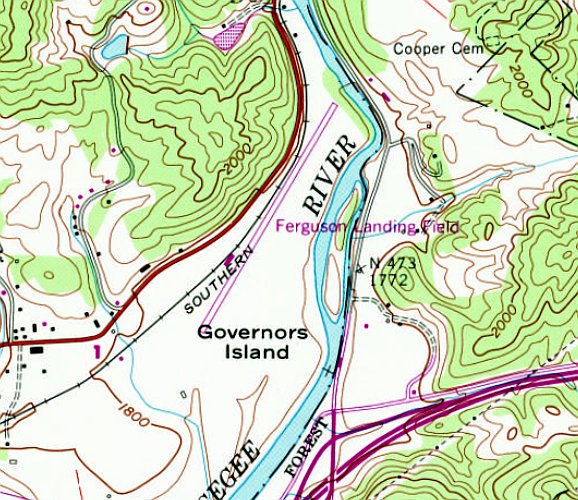
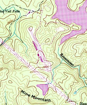
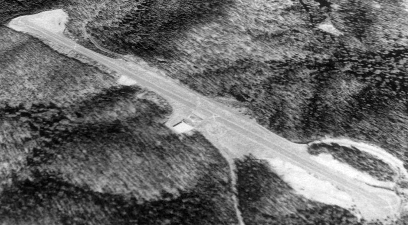
Ferguson Landing Field, as depicted on the 1978 USGS topo map.
This short-lived little general aviation airport was evidently established at some point between 1971-78,
as it was not yet depicted on the October 1968 Charlotte Sectional Chart nor on the 1971 USGS topo map.
The only map or chart depiction which has been located of Ferguson Landing Field was on the 1978 USGS topo map.
It depicted Ferguson Landing Field as having an single paved northeast/southwest runway, and one building on the west side.
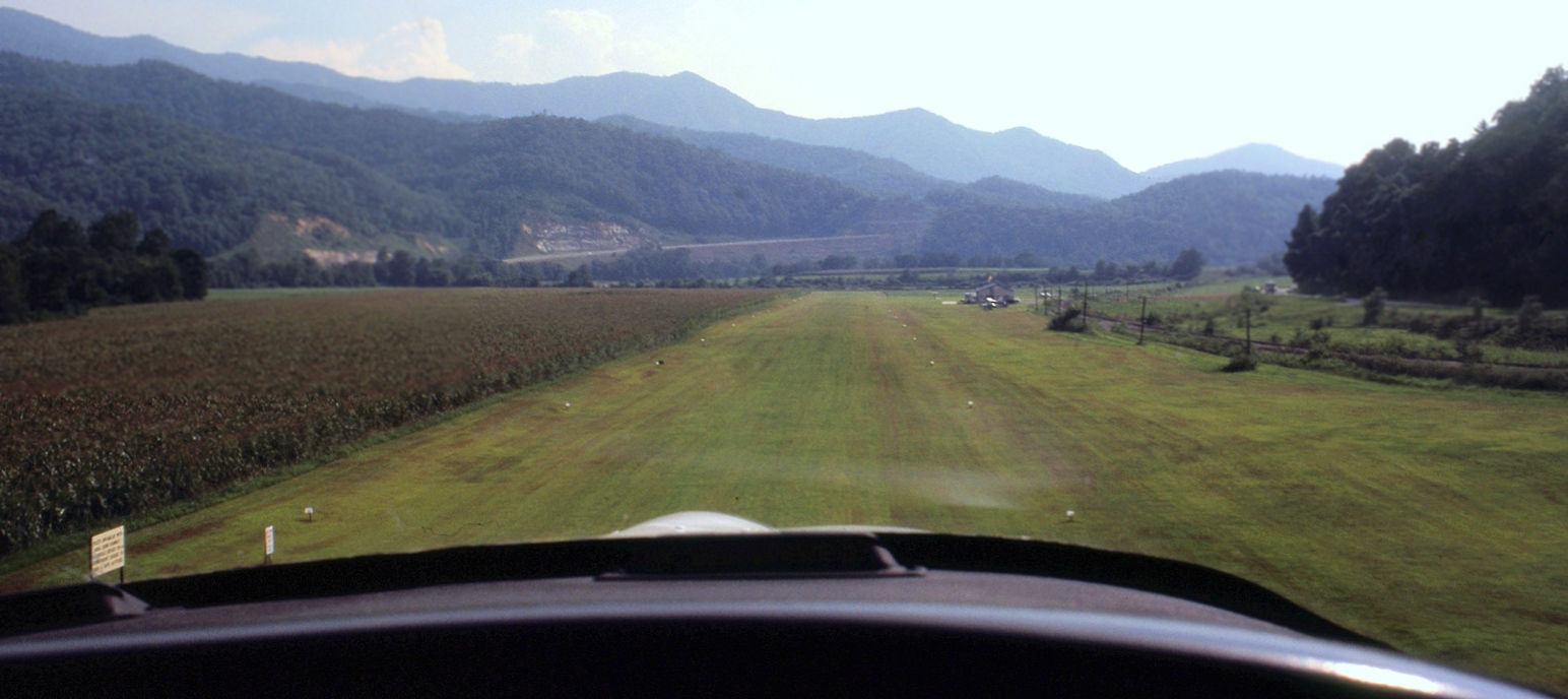
The earliest photos which have been located of Ferguson Landing Field was a series of August 1978 photos by Malcolm Taylor.
Malcolm recalled, “We were on a joyride from Atlanta's Peachtree airport, landing at Sevierville & Bryson.”
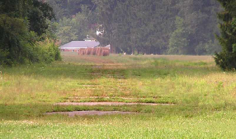
This photo looked southwest on final approach, with a tall cornfield abeam.
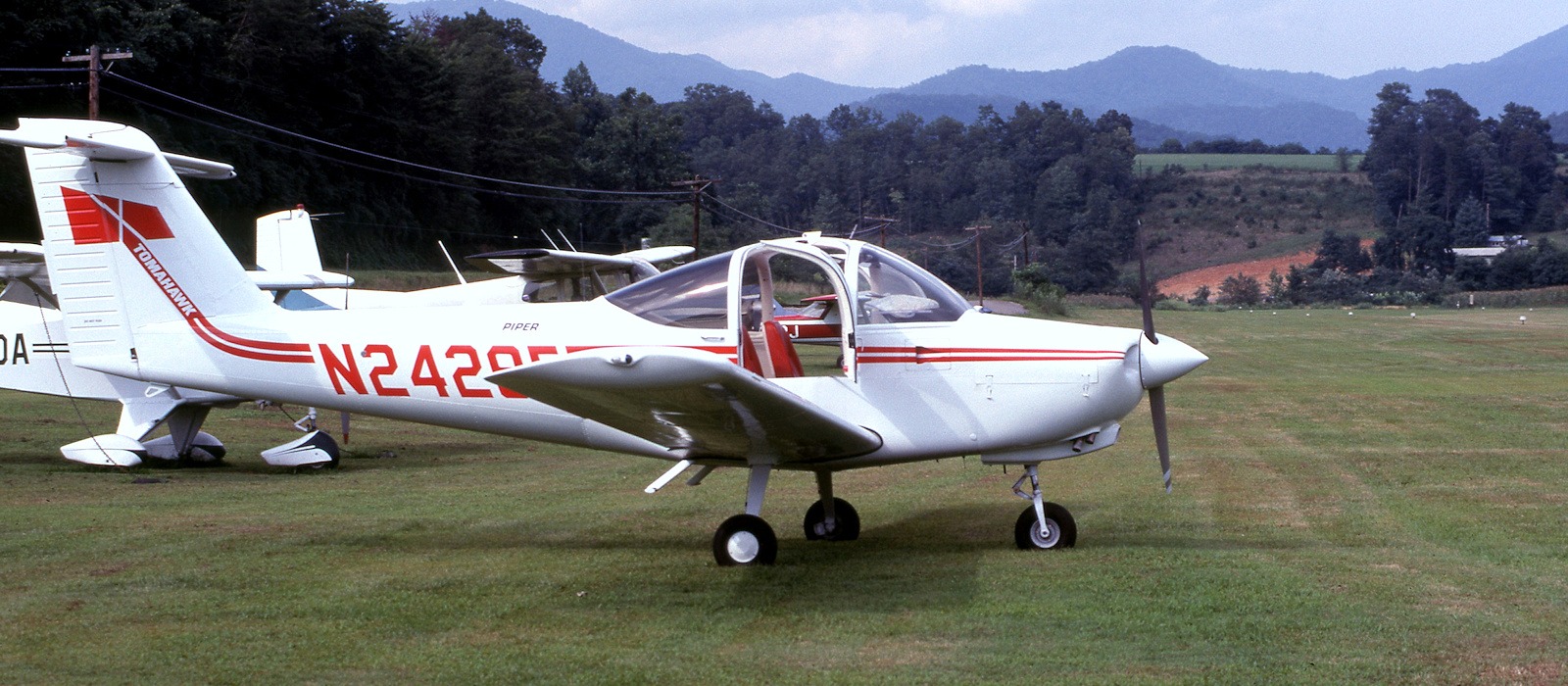
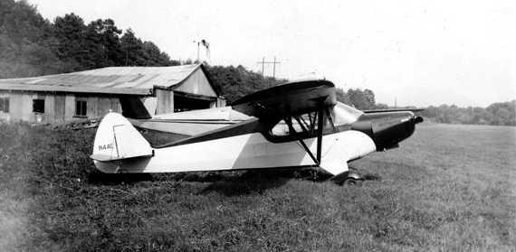
An August 1978 photo by Malcolm Taylor of his Piper Tomahawk at Ferguson Landing Field.
Malcolm observed, “This shows our Tomahawk and, beyond, the gap in the trees that my pilot friend had just threaded through.”
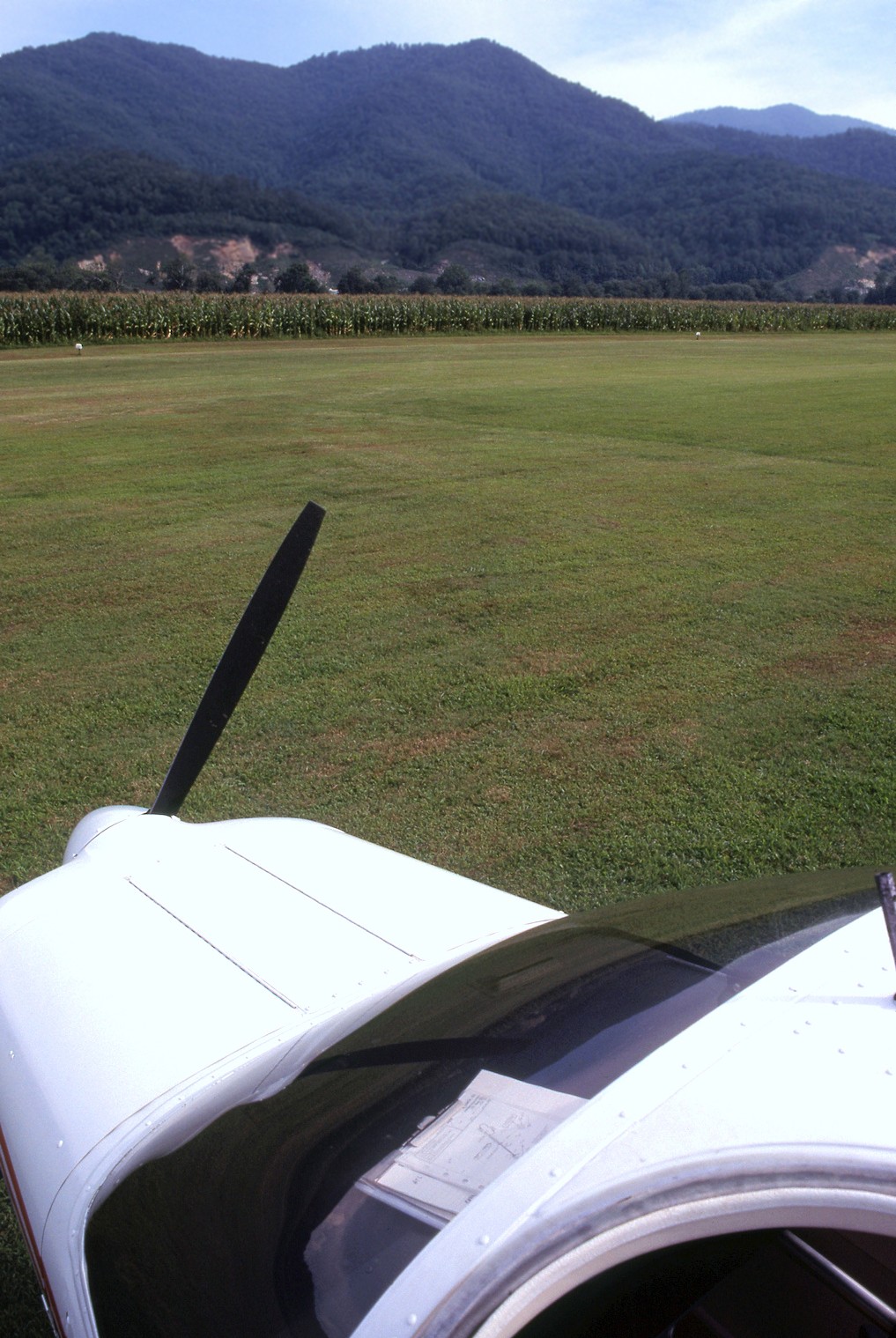
An August 1978 photo by Malcolm Taylor of Ferguson Landing Field & his Piper Tomahawk.
Malcolm observed, “A good view of the corn & the 3,000' plus high ground to the south.”
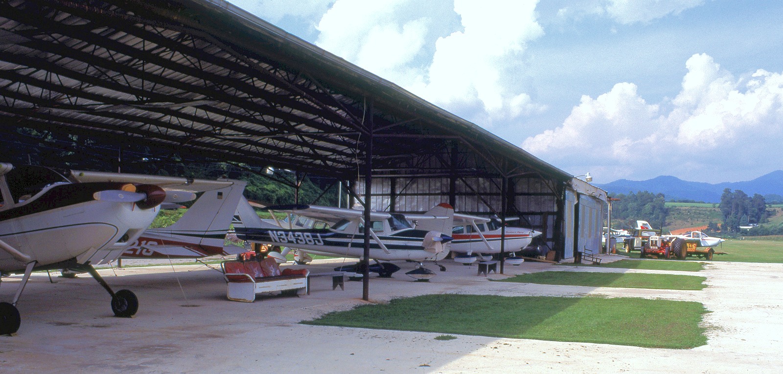
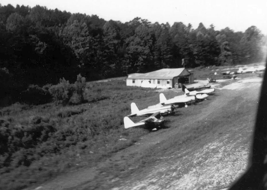
An August 1978 photo by Malcolm Taylor of planes under the shade hangar at Ferguson Landing Field.
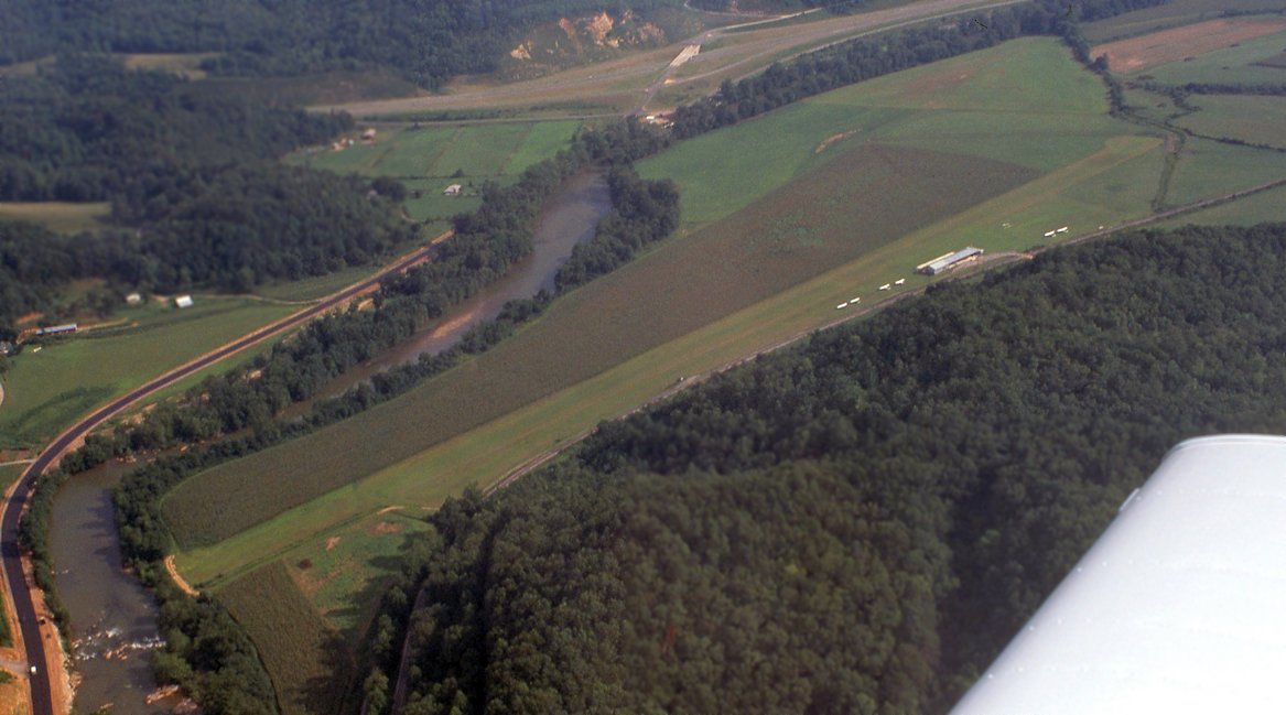
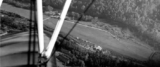
An August 1978 aerial view by Malcolm Taylor looking south at Ferguson Landing Field & the Tuckasegee River on departure.
The airfield consisted of a single grass northeast/southwest runway,
with a long hangar & 6 light single-engine planes on the west side.
Ferguson Landing Field may have been closed by 1986, as a 1986 aerial view showed the runway & building remained intact,
but there were no aircraft visible on the field, nor any other indication of recent aviation use.
A 1994 aerial view showed a road cutting across the middle of the former Ferguson Landing Field runway.
Ferguson Landing Field was no longer depicted on the 2013 USGS topo map nor on the August 2016 Atlanta Sectional Chart.
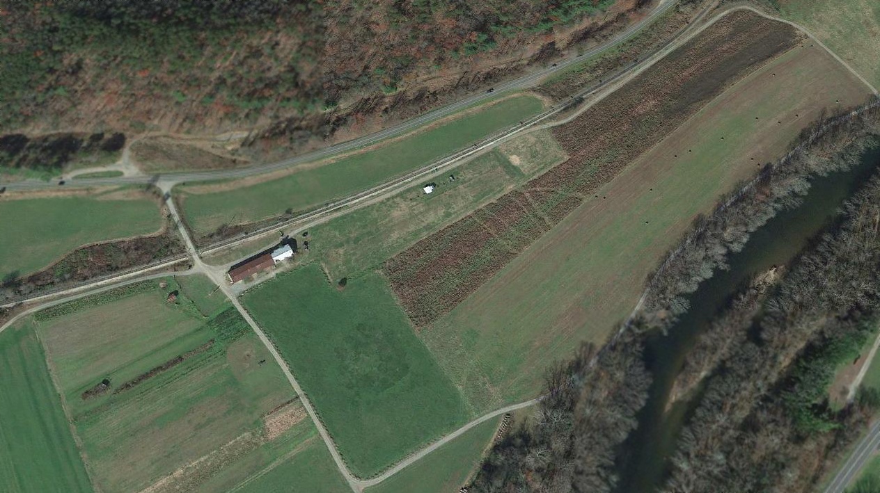
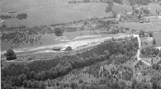
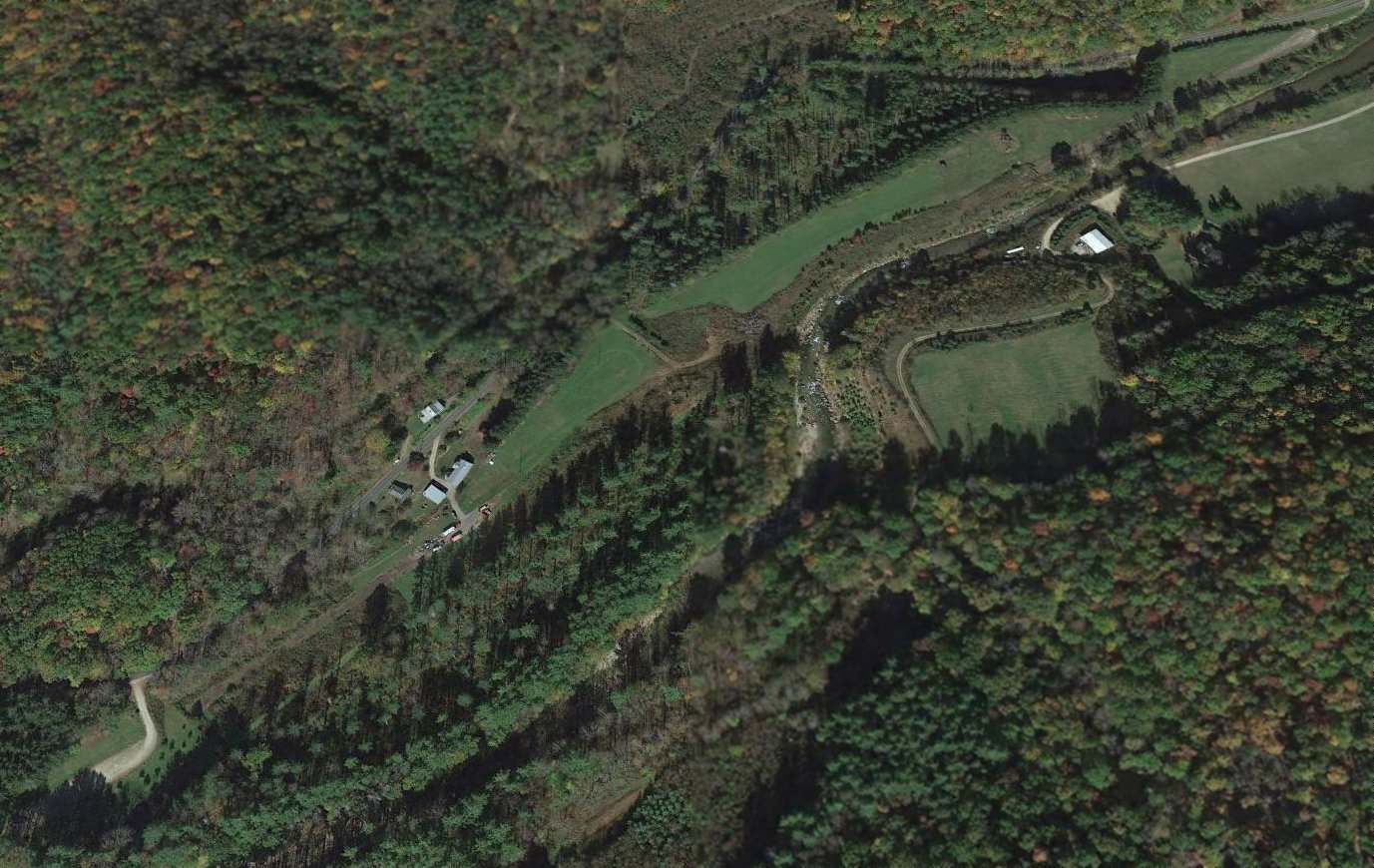
A 2017 aerial view looking northwest at Ferguson Landing Field.
The former runway had reverted to cultivation & was no longer recognizable, but the former hangar remained on the west side.
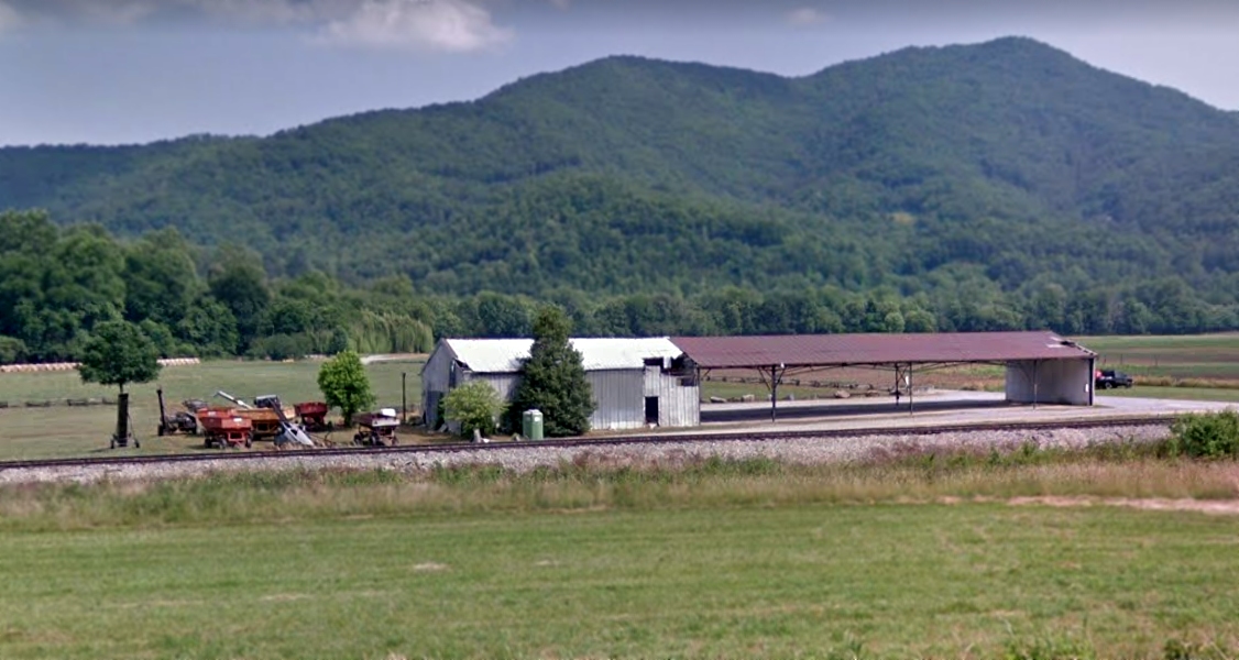
A June 2019 photo looking southeast at the former Ferguson Landing Field hangar.
Thanks to Malcolm Taylor for pointing out this airfield.
____________________________________________________
Brevard Airport (NC16), Brevard, NC
35.223, -82.726 (West of Asheville, NC)
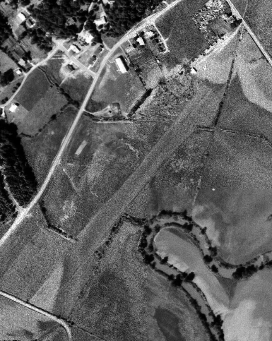
A 10/7/64 USGS aerial view of Brevard Airport.
According to its FAA Airport/Facility Directory data, Brevard Airport was activated in April 1962.
The earliest photo which has been located of Brevard Airport was a 10/7/64 USGS aerial view.
It depicted Brevard Airport as having an unpaved southwest/northeast runway,
with 7 T-hangars & one light single-engine aircraft on the northeast side.
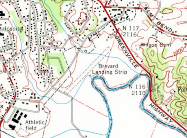
The 1965 USGS topo map depicted “Brevard Landing Strip” as having an unpaved southwest/northeast runway,
with a few small buildings on the northeast side.
The earliest aeronautical chart depiction which has been located of Brevard Airport
was on the April 1965 Charlotte Sectional Chart.
It depicted Brevard as a public-use airport having a 2,100' unpaved runway.
The October 1968 Charlotte Sectional Chart depicted Brevard as a public-use airport having a 2,100' unpaved runway.
The only reference which has been located to someone flying from Brevard Airport came from Jack Rhyne,
who recalled, “It brought back memory of a [Part] 135 SP charter trip out of Shelby to Brevard in 1973.
My boss Joe Rose had me fly in there in the morning - wet grass - with 2 passengers in a [Cessna] 310 - 2,100' grass - ooooo ya!
I got my MEL & ATP in a 310 so I thought NO PROBLEM. I briefed my passengers as to landing in Brevard with sounds - stall warning - LOL. I landed with no problems.
After a couple hours another brief on departure sounds. Not to mention a BELOW-Vmc takeoff ! Back at Shelby I told Joe Brevard was very risky indeed!”
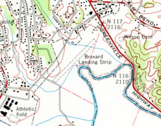
The 1997 USGS topo map continued to depict “Brevard Landing Strip” as having an unpaved southwest/northeast runway,
with a few small buildings on the northeast side.
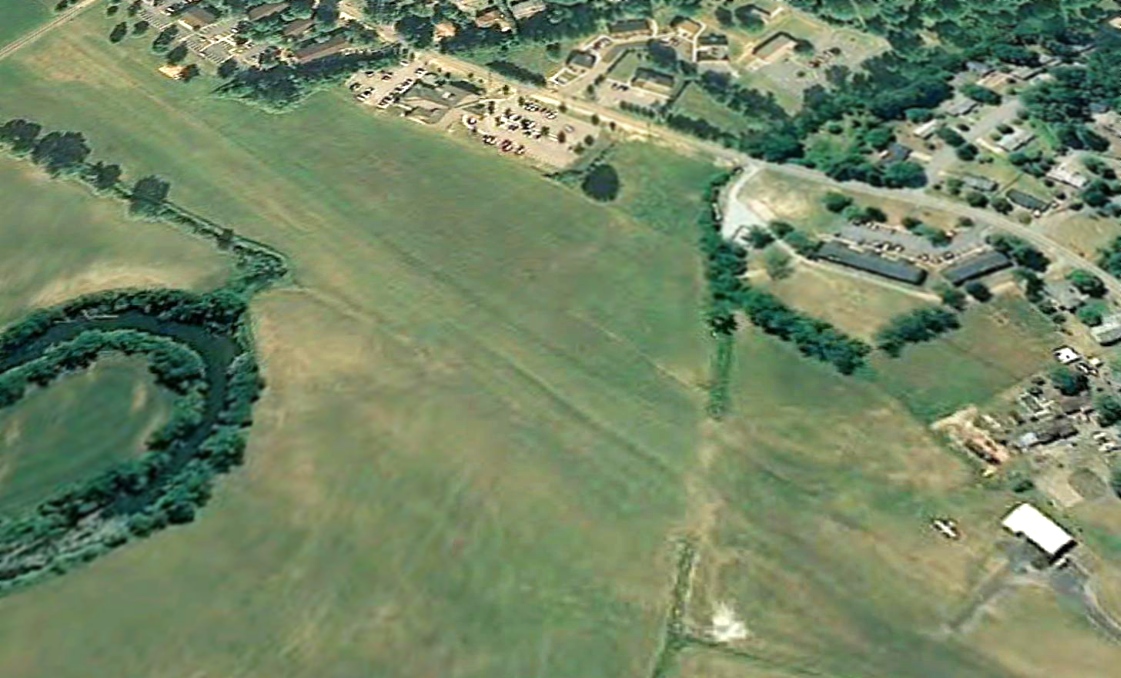
The last photo which has been located showing an aircraft at Brevard Airport was a 2008 aerial view looking west,
which showed one light single-engine aircraft parked on the northeast side.
The multiple T-hangars had been replaced by one slightly larger hangar at some point between 1964-2008.
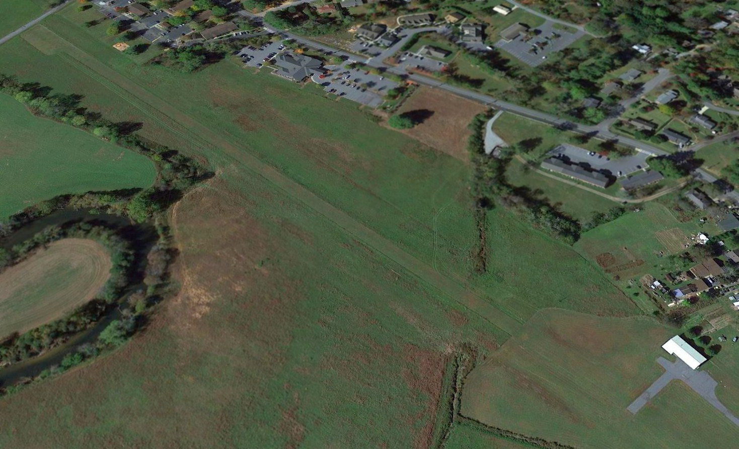
A 2015 aerial view looking west showed Brevard Airport remained intact, but devoid of aircraft.
As of 2017, the FAA Airport/Facility Directory described Brevard Airport as having a 2,100' turf Runway 4/22, and being owned & managed by Valley Auto Sales.
However, its remarks said “Airport closed indefinitely.”
Brevard Airport is located south of the intersection of Gallimore Road & Greenville Highway.
Thanks to Larry Kindrick for pointing out this airfield.
____________________________________________________
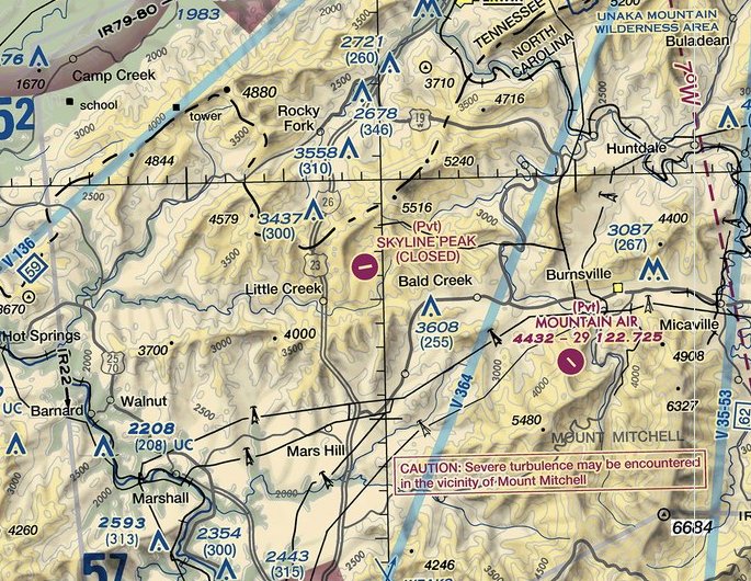
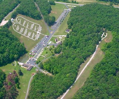
Wolf Ridge Airport / Skyline Peak Airport (33NR), Mars Hill, NC
35.939, -82.515 (North of Asheville, NC)
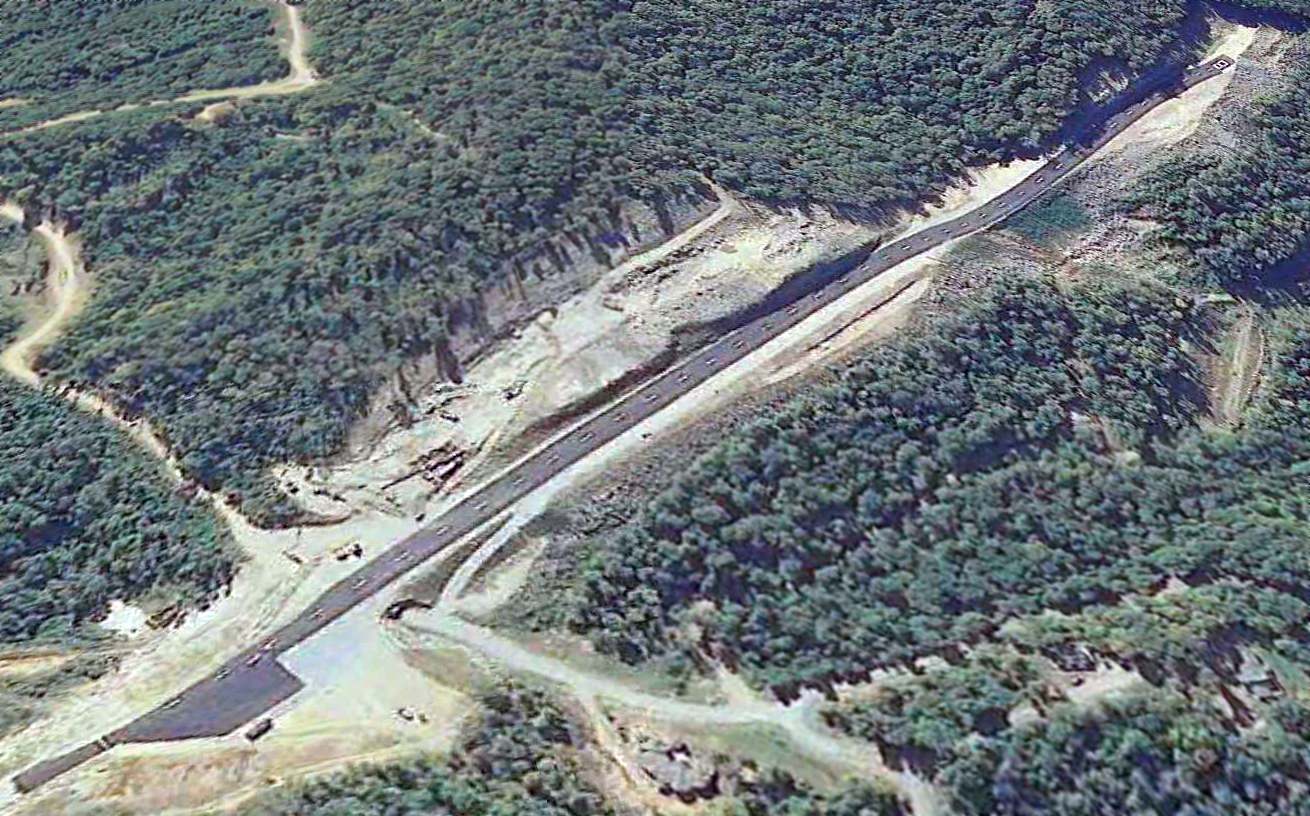
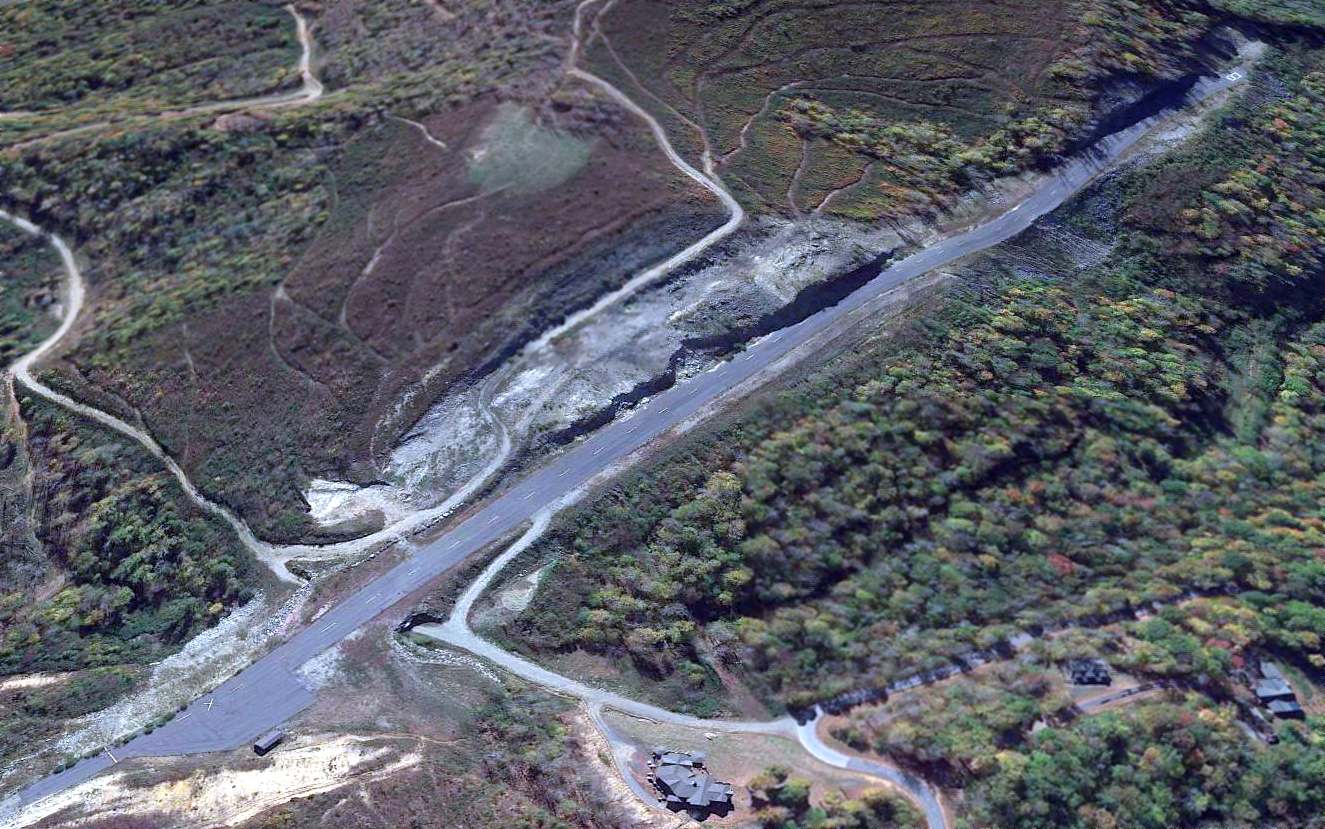
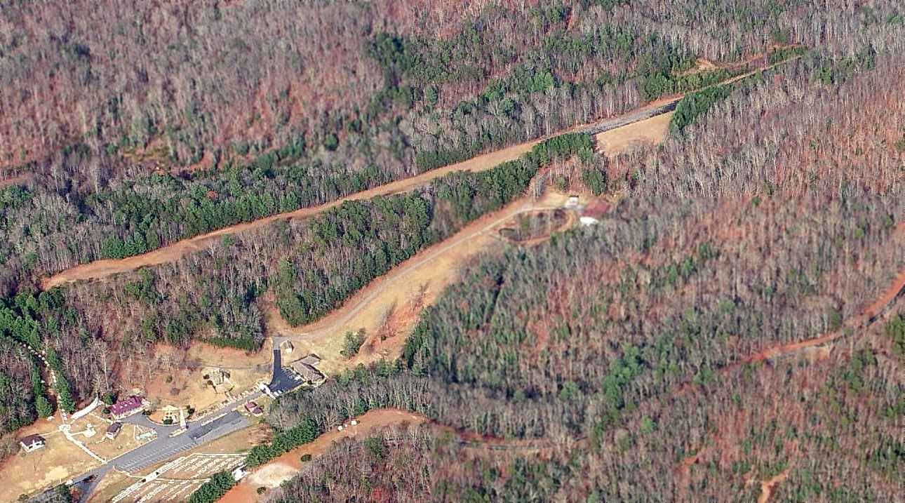
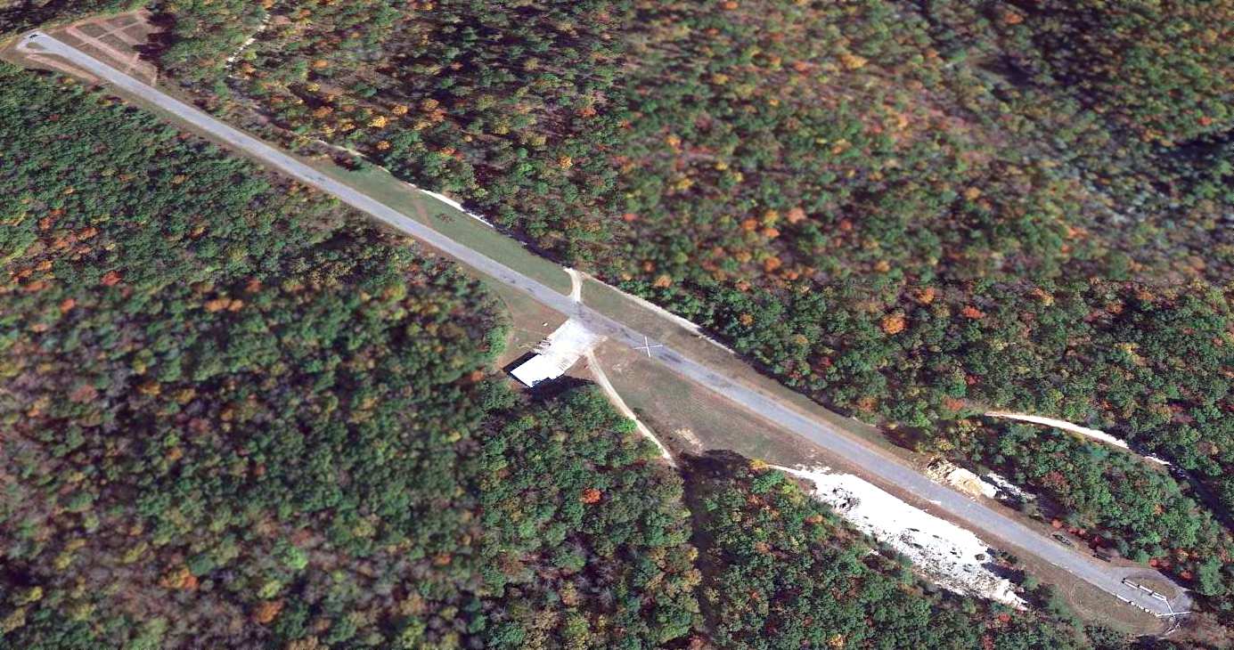
A 2009 aerial view looking southwest at Skyline Peak Airport.
This mountaintop runway, literally carved out of the slope of a mountain at 4,500' elevation,
was evidently built in connection with the Wolf Ridge ski resort, located a half-mile to the northeast.
A 2002 aerial photo showed the mountain before any airfield construction.
A 2005 aerial view showed land being cleared on what would become the eastern portion of the airfield,
with progressively more mountainside being carved away through a series of photos up through 2008.
The FAA Airport/Facility Directory described Skyline Peak Airport as being activated in June 2009.
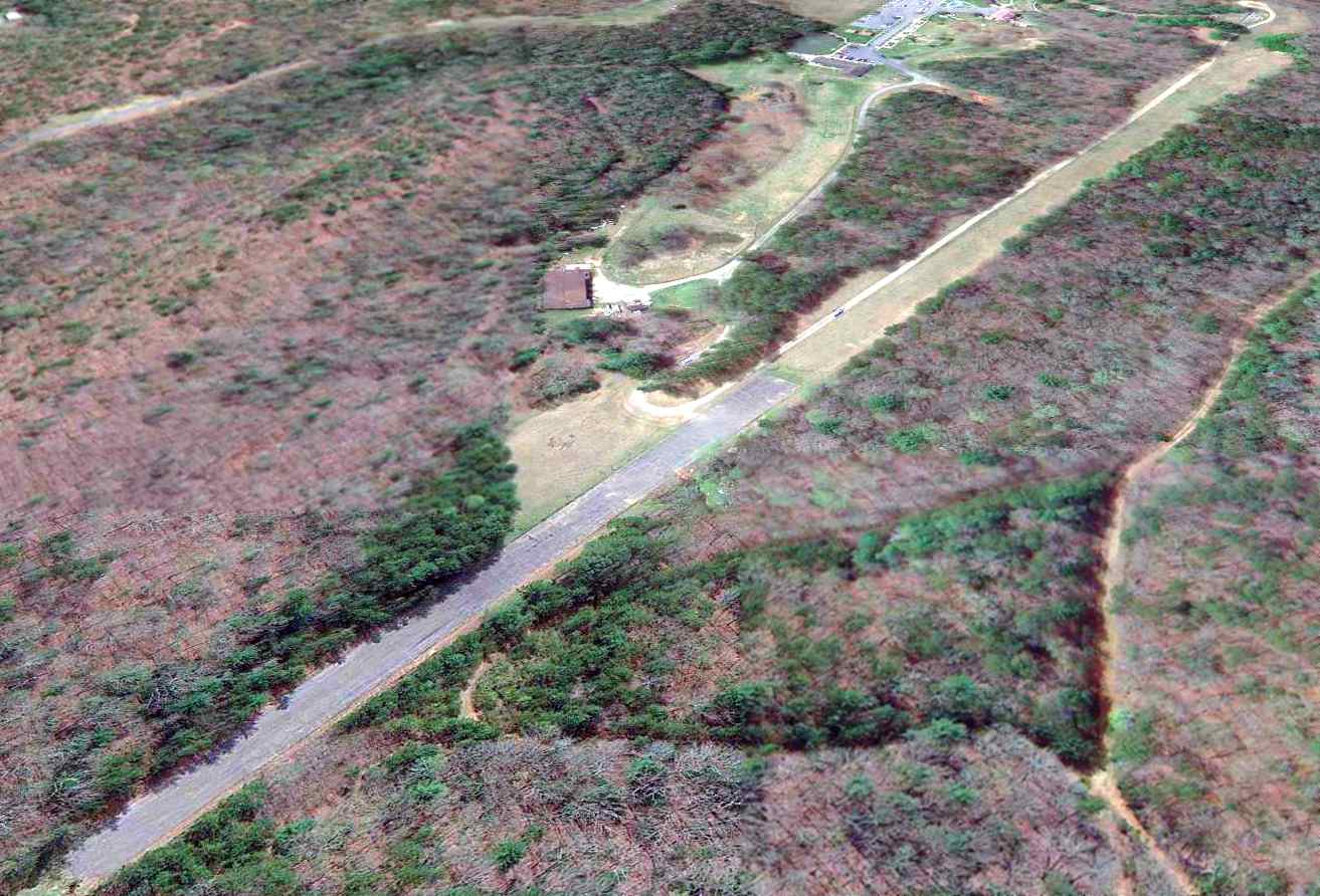
The earliest photo which has been located showing Skyline Peak Airport's completed runway was a 2009 aerial view looking southwest.
It depicted Skyline Peak Airport as having a single asphalt southwest/northeast runway,
with an asphalt ramp & a small building on the northeast side.
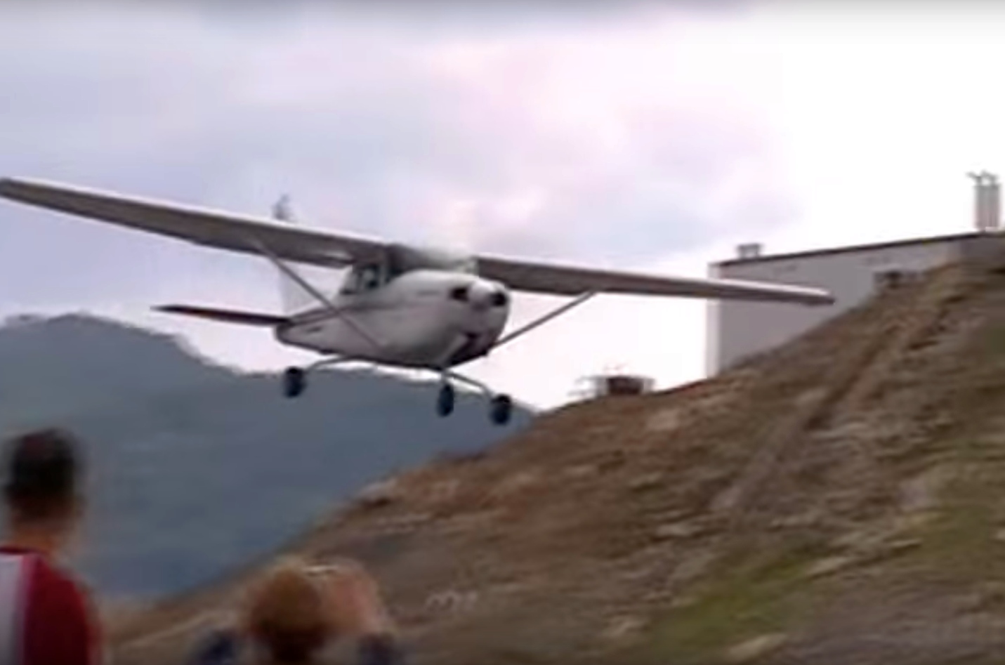
A circa 2010 photo looking east at a Cessna 172 on final approach to was supposedly the first & only landing at Skyline Peak Airport.
A circa 2010 photo looking southwest at a Cessna 172 just before touchdown at was supposedly the first & only landing at Skyline Peak Airport.
Notice the multiple rock walls directly adjacent to the runway, where the strip was excavated from the mountainside.
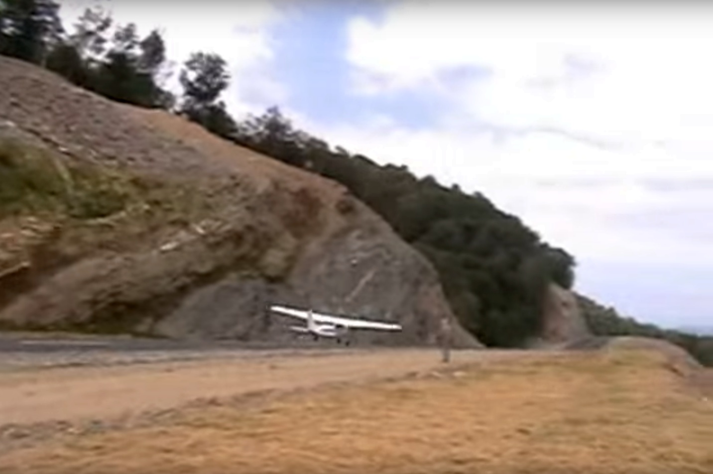
The last photo which has been located showing Skyline Peak Airport still marked with active-runway markings was a 2010 aerial view looking southwest.
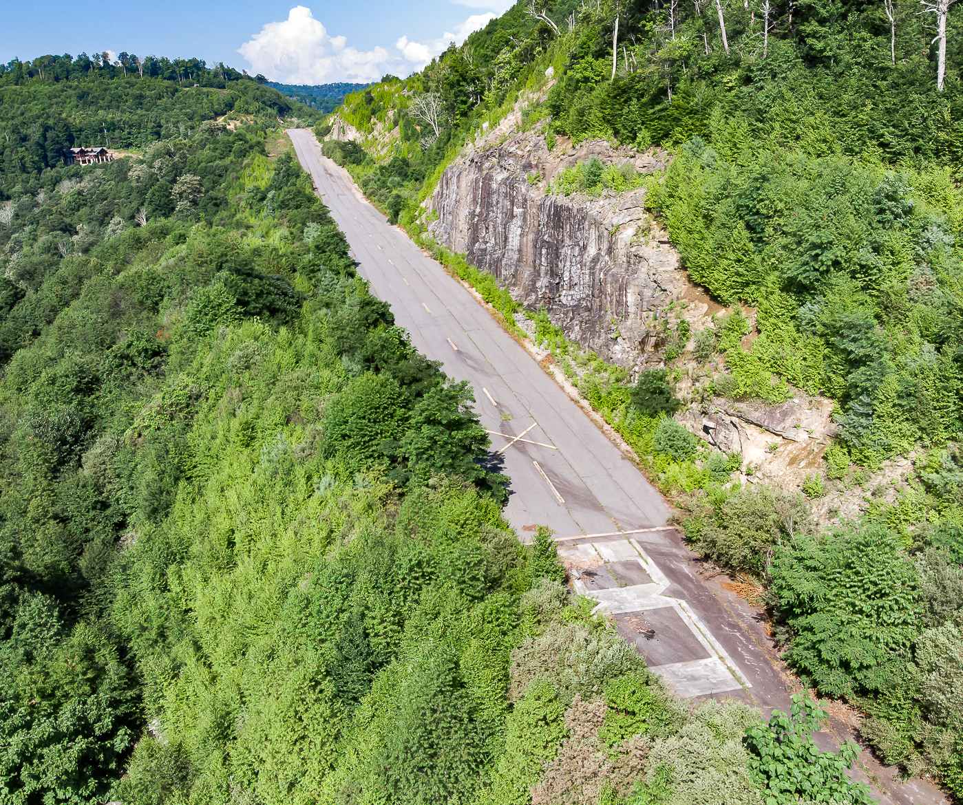
A 2013 photo looking along the Skyline Peak Airport runway. Amazing to think that anyone would have thought this to be a safe runway configuration.
Skyline Peak Airport was evidently closed (for reasons unknown) at some point between 2010-2013,
as a 2013 aerial view showed closed-runway “X” symbols painted on both runway ends.
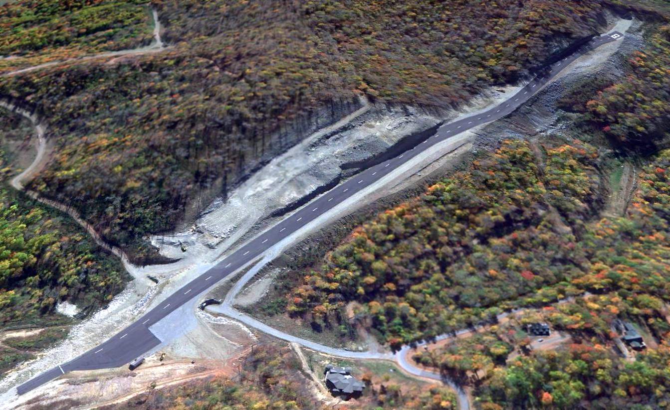
The 2013 USGS topo map labeled the airport as Wolf Ridge Airport, depicting it as having a single paved northeast/southwest runway.
A 2015 aerial view looking southwest at Skyline Peak Airport, showing closed-runway “X” symbols pained on both runway ends.
A 2015 aerial view looking southeast at Skyline Peak Airport.
It was still depicted as Wolf Ridge Airport on the 2016 USGS topo map.
Skyline Peak Airport was still depicted as an active private airfield on the 2016 Sectional Chart,
depicted with a single paved 3,300' southwest/northeast runway.
Even though it was still depicted on the 2016 Sectional Charts, as of 2016 the FAA Airport/Facility Directory data listed Skyline Peak Airport as “Closed indefinitely”.
It was described as having a single 3,300' asphalt Runway 8/26, “in fair condition”,
and to have 1 single-engine aircraft based on the field (although none of the pictures show a based aircraft or any hangar).
It was said to be owned by TW Ventures, and the manager listed as K. Sebok.
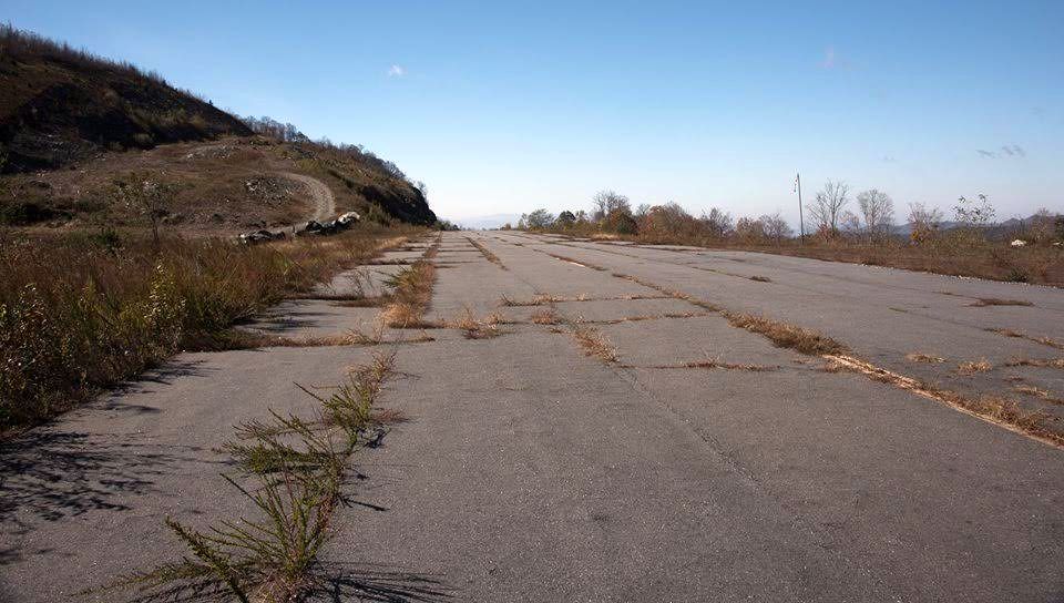
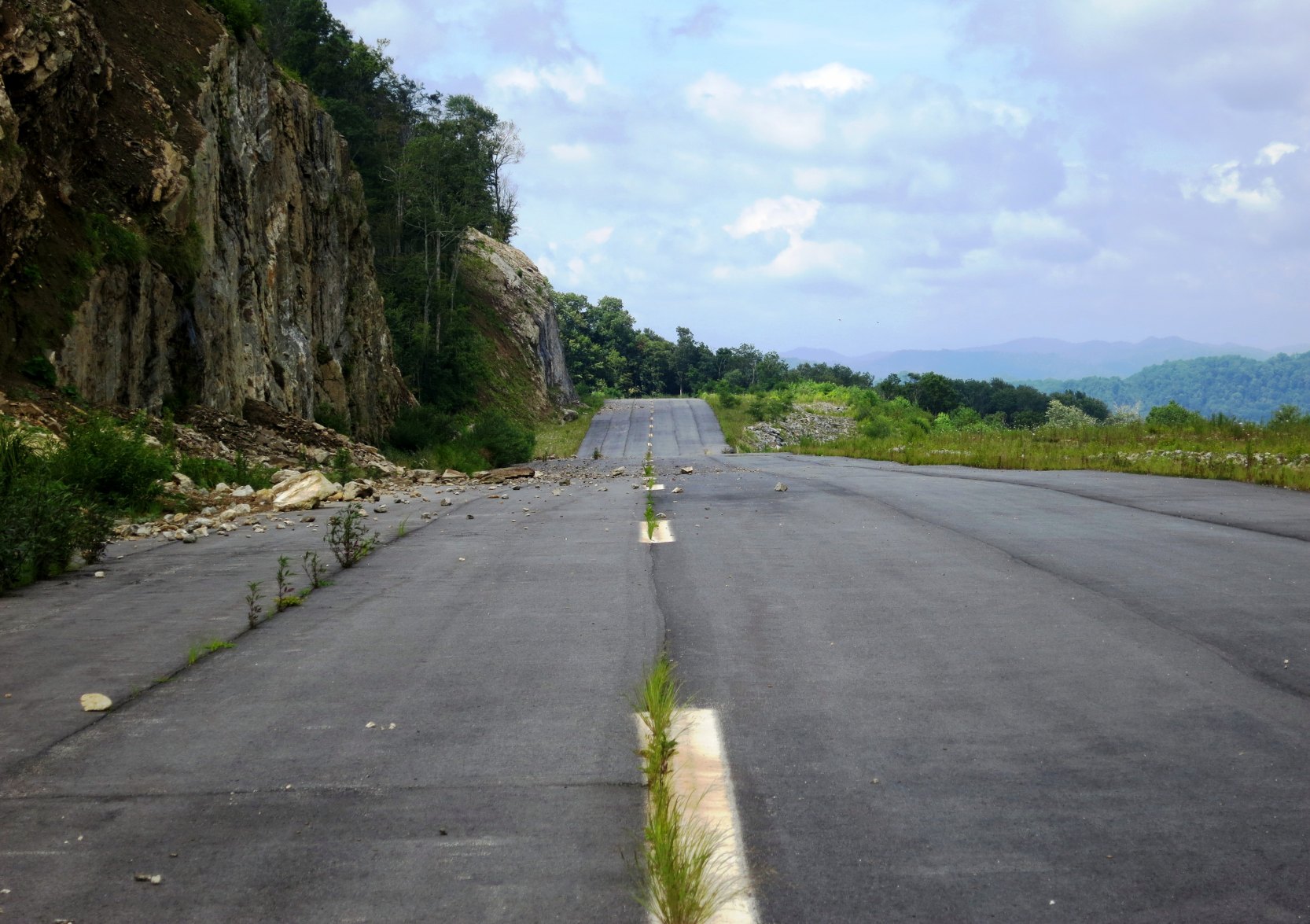
A 2011-2016 photo looking west along the cracked & weed-strewn runway pavement of Skyline Peak Airport.
The 2019 USGS topo map labeled the airport as Skyline Peak Airport.
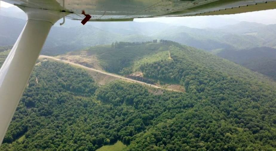
A July 2021 aerial view by Chris Gimmilaro looking southeast along the Skyline Peak Airport runway.
The 2022 Sectional Chart depicted Skyline Peak Airport as closed.
As of 2022, road maps label the airport as Wolf Ridge Airport.
Skyline Peak Airport is located south of the intersection of Wolf Ridge Road & Airport Road, appropriately enough.
Thanks to Rick Harshbarger for pointing out this airfield.
____________________________________________________33.83, -118.02
Fields of the Wood Airfield, Murphy, NC
35.12, -84.25 (Southwest of Asheville, NC)
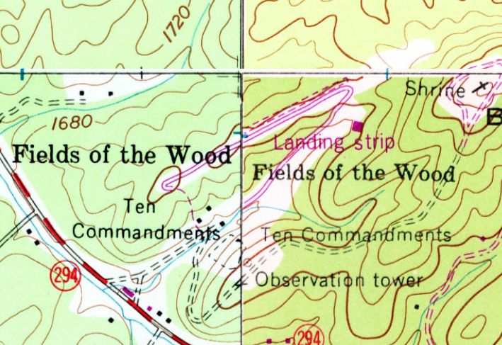
Fields of the Wood Airfield, as depicted on the 1978 USGS topo map.
This private airfield was evidently established at some point between 1968-78,
as it was not yet depicted on the 1968 USGS topo map.
The earliest depiction which has been located of the Fields of the Wood Airfield was on the 1978 USGS topo map.
It depicted a northeast/southwest runway, labeled simply as “Landing Strip”.
According to Wes Floyd, “Its located at a Bible Park called 'Fields of the Wood', operated by the Church of God.
The headquarters for the church was in Cleveland TN & I read that the guy who ran the church flew back & forth.
I was also told when I was a kid that they flew mission work from there.”
The earliest photo which has been located of Fields of the Wood Airfield was a 1981 aerial view.
It depicted Fields of the Wood Airfield as having a single unpaved southwest/northeast runway.
The earliest photo which is available of Fields of the Wood Airfield was a 1992 aerial view looking southwest.
It depicted Fields of the Wood Airfield as having a single unpaved southwest/northeast runway.
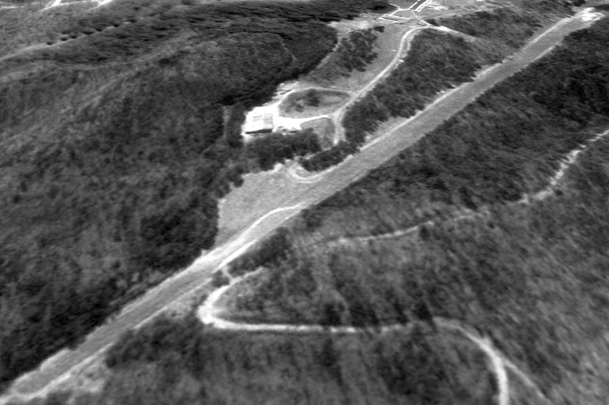
A 2002 aerial view by Wed Floyd looking southwest at the Fields of the Wood Airfield (bottom-right).
A circa 2010 aerial view looking north at the Fields of the Wood Airfield.
A 2014 aerial view looking southwest at the Fields of the Wood Airfield shows that the northeast portion was paved, and the remainder grass.
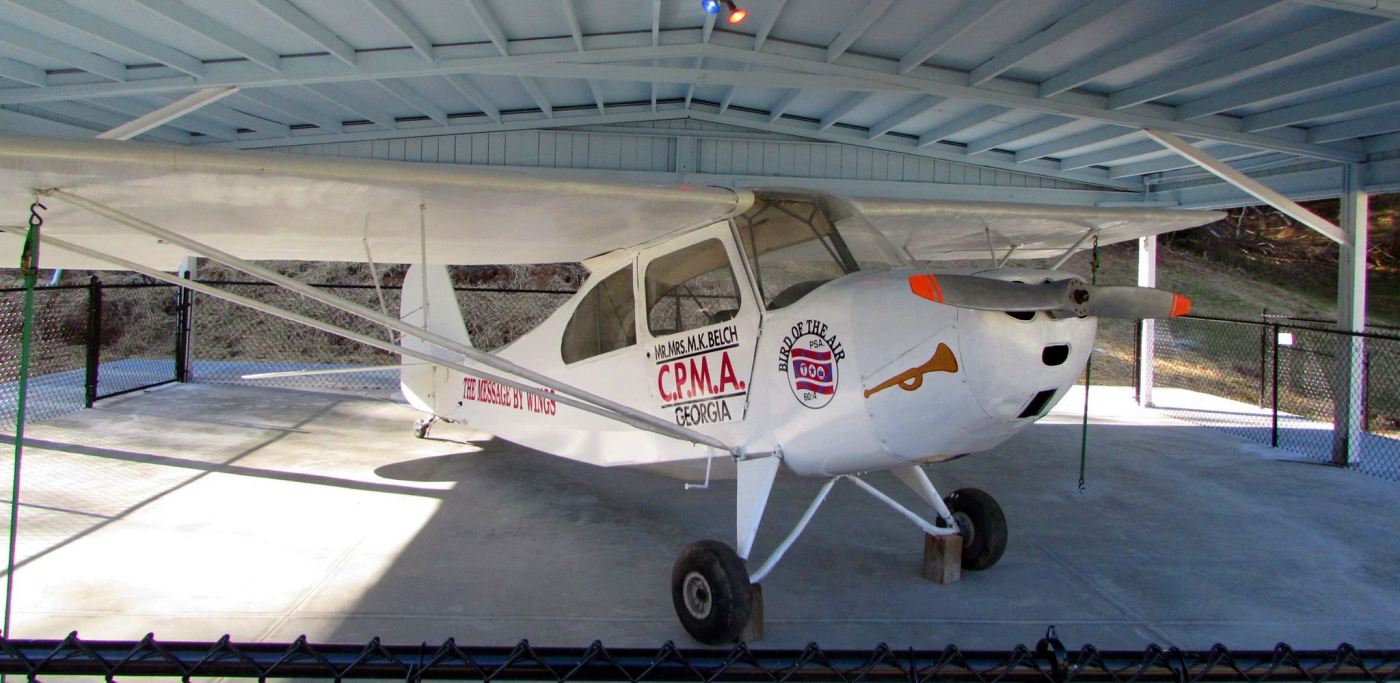
A 2015 photo (courtesy of Wes Floyd) of an Aeronca Champ on display at the Fields of the Wood bible park adjacent to its airfield.
Wes Floyd recalled, “The airplane (a Champ) was on display there when I was a teenager, then it was moved.
A group in California fully restored it & now its back on display.”
It is not known at what point the Fields of the Wood Airfield was closed.
As of 2015 the Fields of the Wood Airfield is no longer registered with the FAA.
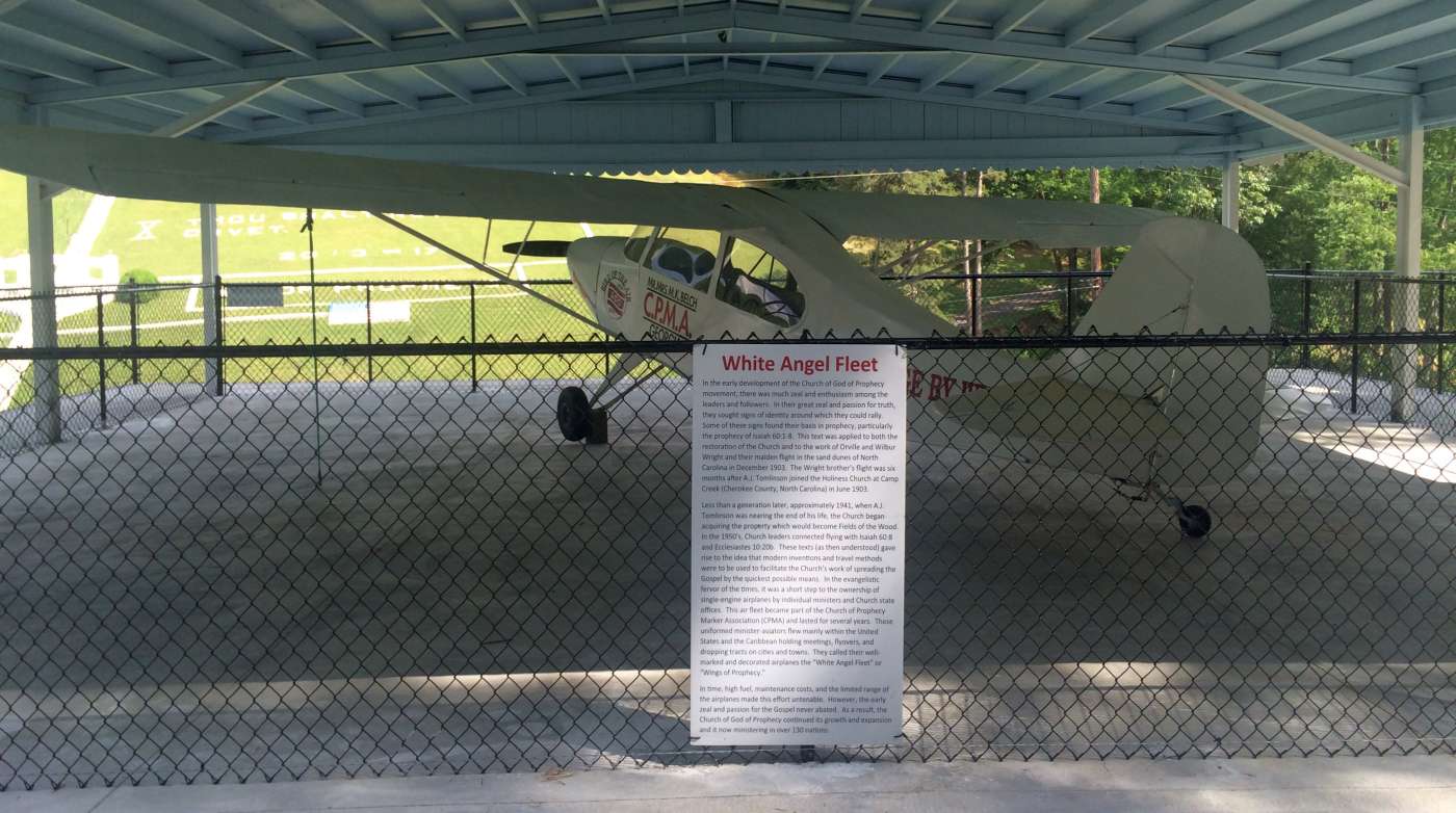
A 6/21/15 photo by Wes Floyd of an Aeronca Champ on display at the Fields of the Wood bible park adjacent to its airfield.
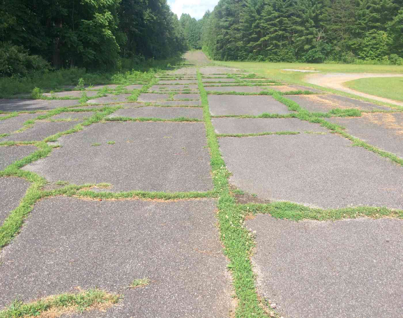
A 6/21/15 photo by Wes Floyd looking east along the paved portion of the Fields of the Wood runway.
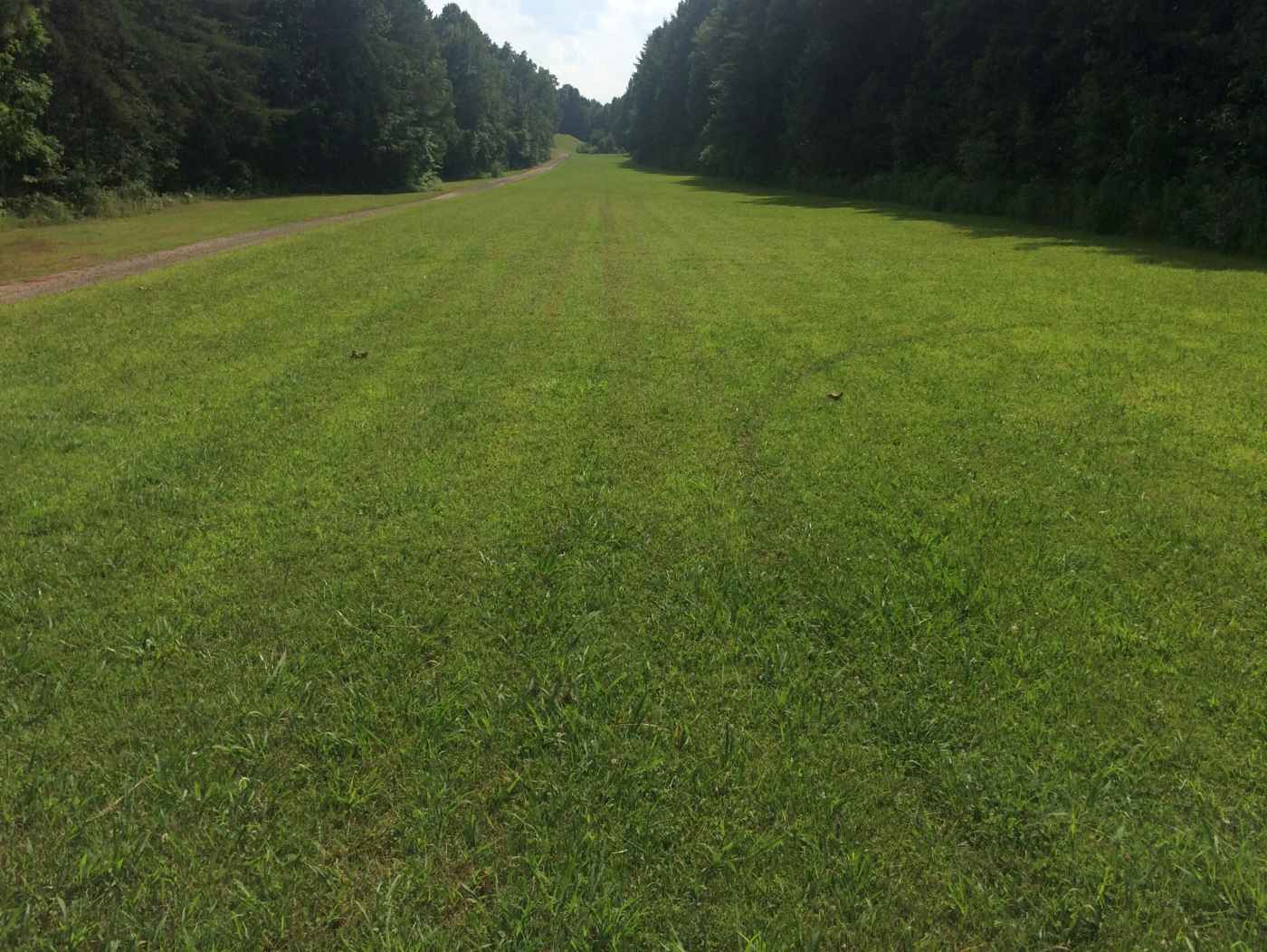
A 6/21/15 photo by Wes Floyd looking west along the grass portion of the Fields of the Wood runway.
Fields of the Woods Airfield is located northwest of the intersection of Route 294 & Shenandoah Road.
Thanks to Wes Floyd for pointing out this airfield.
____________________________________________________
Baird Bottom Landing Strip, Asheville, NC
35.63, -82.56 (North of Downtown Asheville, NC)
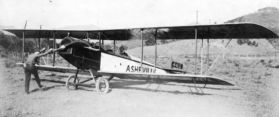
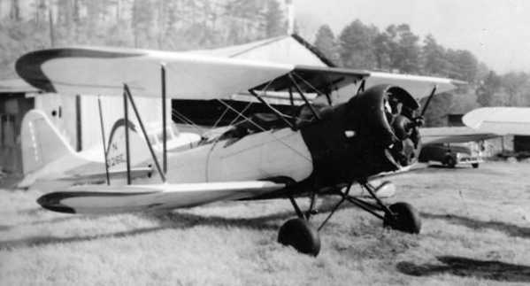
A 6/19/1919 photo of a Curtis JN-4 Jenny marked “Asheville” at Baird Bottom Landing Strip (from the Pack Memorial Library, via Dallam Oliver-Lee).
On 4/19/1911, according to the Asheville Citizen-Times (via Dallam Oliver-Lee),
Lincoln Beachey ceremoniously flew into Asheville to show off his famous aerial stunts over Baird Bottom for the citizens of Asheville.
This flight was one of his pioneering flights over the mountains of Western North Carolina.
That day, although for a brief moment in aviation history, Baird Bottom was Asheville's first unofficial airport.
According to Dallam Oliver-Lee, “My dad's father & his father's grandparents would fly into Asheville via Baird Bottom Landing Strip & stayed at the Grove Park Inn.”
The only depiction which has been located of Baird Bottom Landing Strip
was a 6/19/1919 photo of a Curtis JN-4 Jenny marked “Asheville” (from the Pack Memorial Library, via Dallam Oliver-Lee).
According to Dallam Oliver-Lee, “In the 6/19/1919 picture, Henry Westall prepares to take off from Baird’s Bottom in his plane the Asheville.
Westall was an army Signal Corps pilot in World War I & started a commercial aviation business here in 1919 with shares selling for $50 each.
He purchased a surplus Canadian training plane & some parts, and 'voila' the Asheville Aerial Corporation was in business.
Rides over Asheville were available for $15, a hefty sum at the time.
Also in 1919 Westall was the first aviator to fly over the Blue Ridge.
It took him less than an hour to fly from Asheville to Morganton, NC.
The rest of the story, is hearsay, but interesting.
Henry Westall only flew for about 18 months, and on his last flight, after landing, he kissed the wing of his plane, and never flew again.”
Baird Bottom Landing Strip was not depicted at all on the 1920 USGS topo map.
According to Dallam Oliver-Lee, Baird Bottom Landing Strip closed around 1923 during construction of Beaver Lake,
which was constructed by Charles Waddell & Company.
A 1936 USGS topo map showed Beaver Lake covering the site of Baird Bottom Landing Strip.
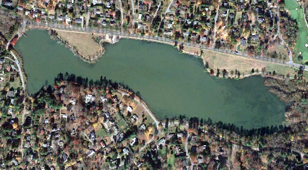
A 2013 aerial photo (courtesy of Dallam Oliver-Lee) showed the site of Baird Bottom Landing Strip covered by Beaver Lake.
The site of Baird Bottom Landing Strip is located south of the intersection of Merrimon Avenue & Marlborough Road.
____________________________________________________
Franklin Airport, Franklin, NC
35.18, -83.369 (Southwest of Asheville, NC)
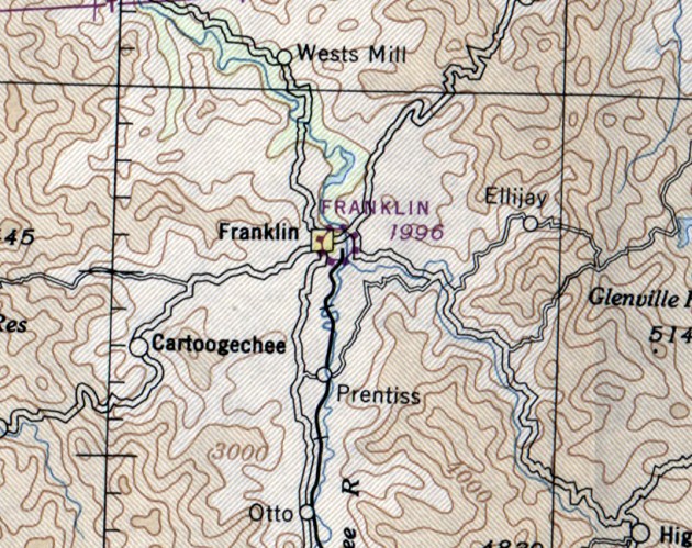
Franklin Airport, as depicted on the October 1946 Charlotte Sectional Chart.
This small general aviation airport along the east bank of the Little Tennessee River was evidently established at some point between 1945-46,
as it was not yet depicted on the 1935 USGS topo map
nor on the April 1945 Charlotte Sectional Chart.
The earliest depiction which has been located of Franklin Airport was on the October 1946 Charlotte Sectional Chart,
which depicted Franklin as a commercial/municipal airport.
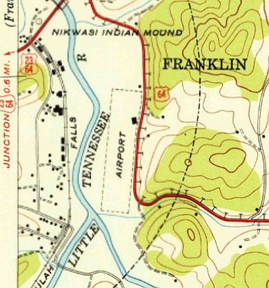
The 1946 USGS topo map depicted Franklin Airport as a single unpaved north/south runway, labeled simply as “Airport”,
with a single small building on the northeast side.
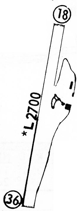
The 1968 Flight Guide (courtesy of Bob Levittan)
depicted Franklin Airport as having a single unpaved 2,700' Runway 18/36, with 2 small buildings on the east side.
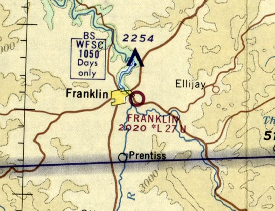
The last aeronautical chart depiction which has been located of Franklin Airport was on the October 1968 Charlotte Sectional Chart.
It depicted Franklin as having a 2,700' unpaved runway.
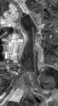
The earliest photo which has been located showing Franklin Airport was a 4/12/75 USGS aerial view (courtesy of Dallam Oliver-Lee).
It depicted Franklin Airport as having a single north/south runway.
The last labeled depiction which has been located of Franklin Airport was on the 1978 USGS topo map.
Franklin Airport had evidently been abandoned (for reasons unknown) by 1994,
as the 4/1/94 USGS aerial photo (courtesy of Dallam Oliver-Lee) depicted the runway as being overgrown.
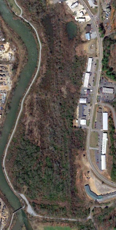
A 3/18/13 aerial photo (courtesy of Dallam Oliver-Lee) still showed a barely recognizable trace of the Franklin Airport runway.
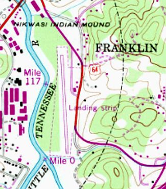
The site of Franklin Airport is located west of the intersection of Route 28 & Thomas Heights Road.
____________________________________________________
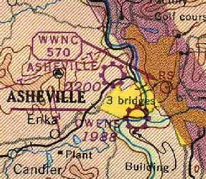
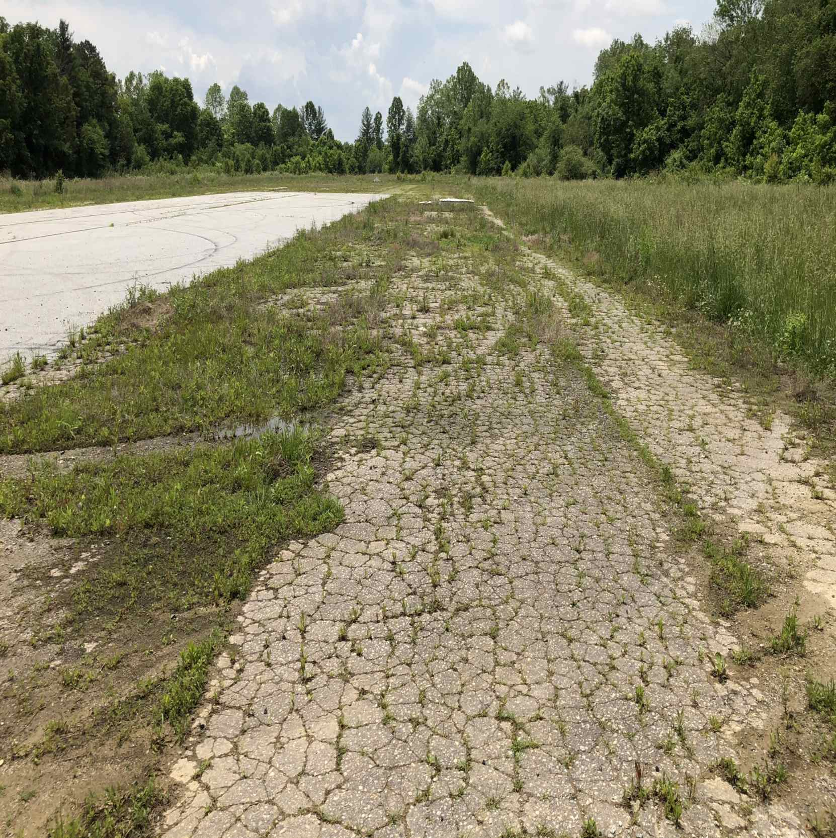
Carrier Field / Owens Field, Asheville, NC
35.57, -82.58 (Southwest of Downtown Asheville, NC)
Owens Field, as depicted on the April 1947 Charlotte Sectional Chart.
This small general aviation airport was located directly along the north bank of the French Broad River,
and was evidently established at some point between 1946-47,
as it was not yet depicted on the 1943 USGS topo map nor on the October 1946 Charlotte Sectional Chart.
According to James Brown, “Before it became Owen it was known as Carrier Field.”
The earliest depiction which has been located of Owens Field was on the April 1947 Charlotte Sectional Chart,
which depicted "Owens" as a commercial or municipal airport.
The earliest photo which has been located of Owens Field was a circa 1940s aerial view taken during a landing of Piper J2 Cub NC17984,
showing a dozen light aircraft (including 2 surplus Vultees) parked near a hangar.
George Allen recalled, “I remember vividly the time when a military bomber had to make an emergency landing at what we knew as Carrier Field (Owens Field);
this would have been in the late 1940s or early 1950s.
The aircraft had to be fitted with JATO bottles & a extremely talented pilot was assigned to fly it out.”
"Owen" was depicted on the August 1954 USAF Sectional Chart (courtesy of Chris Kennedy)
as having a 3,000' unpaved runway.
A 1955 aerial view by James Brown looking southeast at Owen Field,
“made from a Bruner-Winkler Bird biplane that belonged to my flight instructor, George Marshall.
I learned to fly at Owen Field in the summer of 1955. That sure was the good old days.
I spent many Sunday afternoons around the old hangar, listening to all the 'hangar flying' that was always going on.”
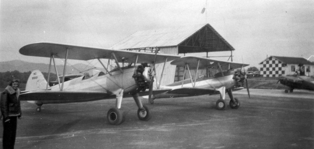
A 1955 photo by James Brown of a Piper PA-12 Super Cruiser & V-tail Bonanza in front of the Owen Field hangar.”
A 1957 photo by James Brown of “a Waco UPF-7 parked at Owen Field, while being rebuilt by Jack McMinn.
It is the airplane... called 'Big Sid' which the boys helped to recover.”
Jackie Smith recalled, “The old Carrier Field... I spent a lot of Sundays with my dad [Jack McMinn],
and Doc Owens, George Marshall, and the crowds that would fill the airport with their cars, for an acrobatic show from my father.
I can remember the days my dad flew his plane & was always in the air.
I did go up several times, but I didn't like being turned upside down, all of the time... ha!
My father was a very talented man, and loved his airplanes.”
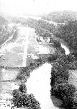
A 1960 aerial view by David Hawkins looking west along the river showing the former Owen Field runway,
and the racetrack which had been built over the middle of the runway.
David recalled, “I raced at the speedway for 7 years.
Interstate 40 had not yet been built but the airstrip was very visible.”
The 1961 USGS topo map (courtesy of Dallam Oliver-Lee) depicted “Owen Airfield” as having a single unpaved east/west runway,
with a single small building on the south side.
"Owen" Field, as depicted on the January 1961 Charlotte Sectional Chart (courtesy of Chris Kennedy).
The 1962 AOPA Airport Directory (based on a latest report from 1960)
described Owen Field as having a single 3,000' turf Runway 9/27,
and listed the operator as Dr. J. E. Owen.
Owen Field apparently closed (for reasons unknown) at some point between 1961-63,
as it was no longer depicted on the May 1963 Charlotte Sectional Chart (according to Chris Kennedy).
According to James Brown, “In yesteryears it is where the circus that came to Asheville was held.”
The last labeled depiction which has been located of Owen Field was on the 1964 USGS topo map (courtesy of Dallam Oliver-Lee).
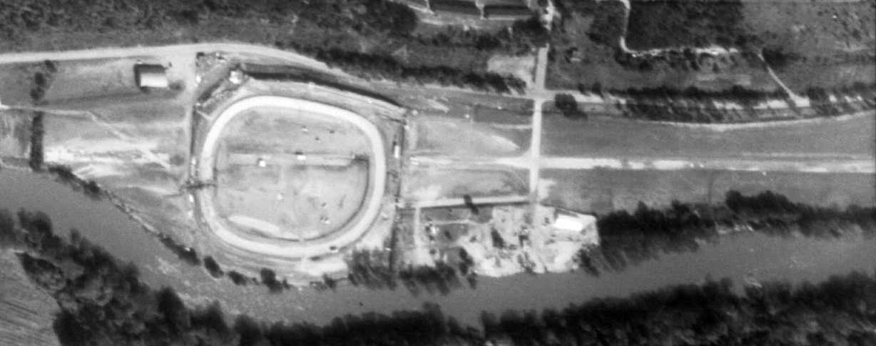
A 9/1/64 USGS aerial view showed that an oval track (the new Asheville Motor Speedway) had been built over the western portion of the Owen Field runway,
but the remains of the majority of the runway still extended out in both directions.
What may have been a former hangar was visible on the northwest side.
By the time of the 1972 USGS topo map, Owen Field was no longer depicted.
A 4/26/84 USGS aerial photo (courtesy of Dallam Oliver-Lee) showed that the western end of the Owen Field runway had been replaced by a parking lot.
The history of this property took another turn in 1999 when the Asheville Motor Speedway was closed.
The owner of the speedway sold it to a non-profit organization called Riverlink,
which quickly placed deed restrictions on the property that outlawed racing on the site
and then gave the land to the City of Asheville for a new riverside park.
Apparently, the sale also included stipulations that the racetrack facilities could not be given historic designation,
so the city would be free to modify or remove them as it saw fit.
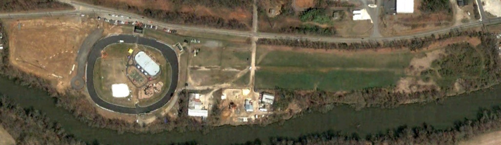
However, the majority of the former speedway has remained intact, reused as a bicycling velodrome.
The facility is known as the French Broad River Park.
The last photo which has been located still showing traces of Owen Field was a 4/22/02 aerial photo (courtesy of Dallam Oliver-Lee),
with the majority of the runway still recognizable to the east of the racetrack.
A 2004 photo by William Stephens, looking east along what would have been one of the final approach paths to Owen Field.
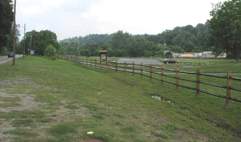
Strangely, the park which now occupies the site contains no mention whatsoever of the site's history as either an airfield or a speedway.
William Stephens visited the site of Owen Field in 2004.
"The only thing they did was go around & replace the red & white stripes on the guardrails & concession stand green & white.
The catch fence is still there (ooh, one of the bicyclists might get going really fast!) with the speakers for the P.A. system still attached.
Alas, they did not leave a trace of the airstrip.
There wasn't much there to begin with, but it was still easy to know where it had been
(a long, straight stretch of asphalt that ran right up to the outer east wall of the speedway)."
Nick Sandin reported in 2006, “I recently had the opportunity to visit the former site of Owen Field.
One interesting thing I found when I was there was a small patch of concrete [located in the center of the former airfield area]
dating from sometime in the 1940s or 1950s
(according to my friend, a construction expert, who was with me at the time).
I also noticed that the parks authority does acknowledge the history of the racetrack there
(it has plans for a building honoring the racetrack on the east side of the facility)
but it does not recognize the history of the airfield that used to exist on the site.”
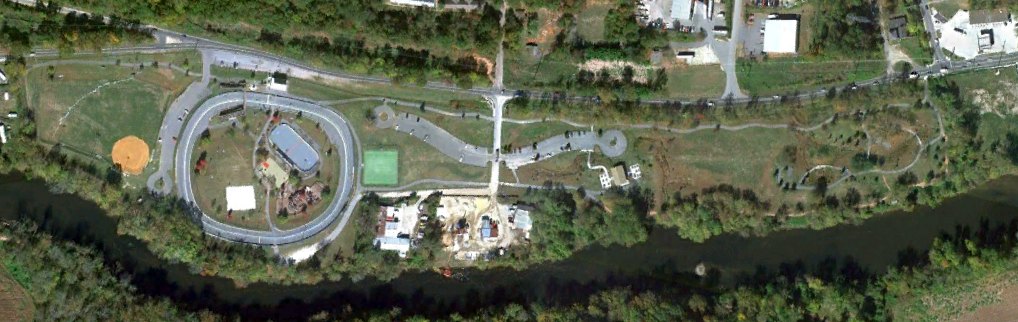
A 10/20/10 aerial photo (courtesy of Dallam Oliver-Lee) showed no remaining trace of Owen Field.
According to David Bishop, the Owens Field site was extensively damaged in 2024 by Hurricane Helene.
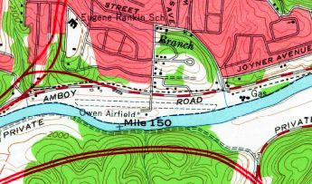
The site of Owen Field is located south of the intersection of Amboy Road & Short Michigan Avenue.
Thanks to William Stephens for pointing out this airfield.
____________________________________________________
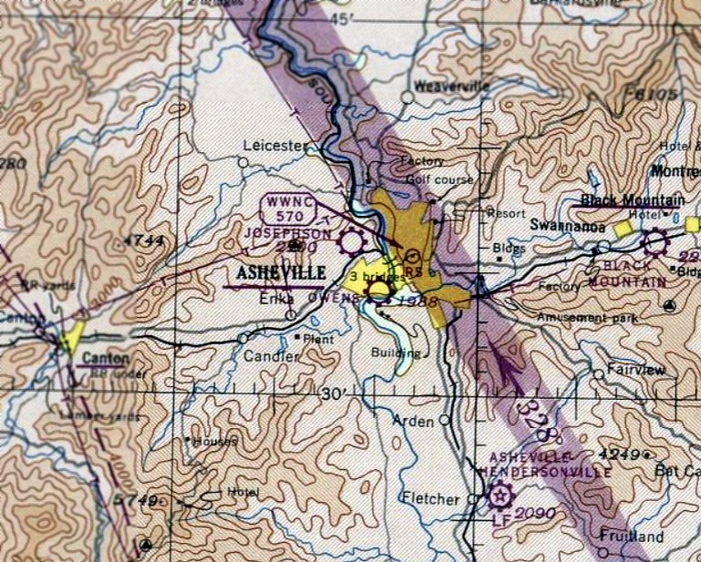
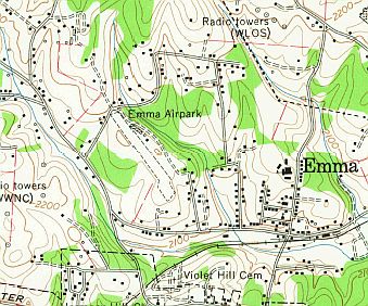
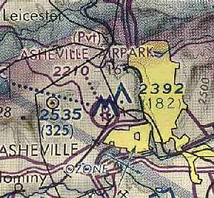
Josephson Airport / Emma Airport / Asheville Airpark, Emma, NC
35.6, -82.6 (West of Asheville, NC)
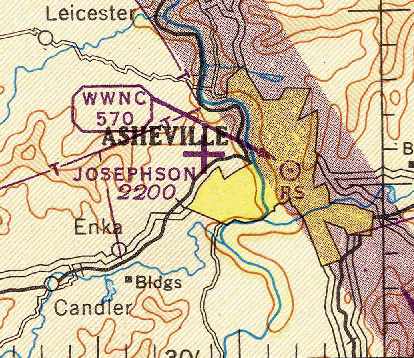
Josephson Airport, as depicted on the April 1946 Charlotte Sectional Chart (courtesy of Chris Kennedy).
The date of construction of Emma Airpark has not been determined
The earliest reference which has been located to Emma Airpark
was from material in the Pack Memorial Library (courtesy of Dallam Oliver-Lee),
which indicated that “Emma Air Park was a 14 acre tract of land located a half mile west of Emma.
On 1/24/28, Harry Brooks, Henry Ford’s test pilot, attempted to fly from Ford Field in Dearborn, MI to Miami, FL.
This first long distance attempt in the Ford Flivver landed short in a forced landing at Emma Air Park in Asheville
although Brooks did set a non-stop distance record in his small, single seat, 36 horsepower plane.
The Detroit craft flew 790 miles on 20 gallons of gas.”
No airport in Emma was yet depicted on the 1943 USGS topo map (courtesy of Dallam Oliver-Lee),
listed among active airfields in the 1945 AAF Airfield Directory (courtesy of Scott Murdock),
nor depicted on the October 1945 Charlotte Sectional Chart.
The earliest depiction of which has been located of an airport in Emma was on the April 1946 Charlotte Sectional Chart (courtesy of Chris Kennedy).
It depicted “Josephson” as an auxiliary airfield.
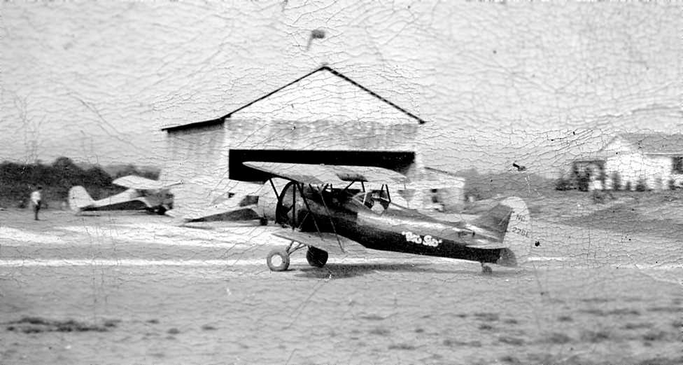
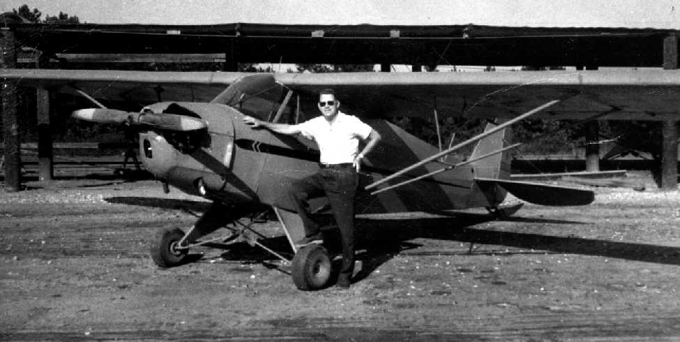
A summer 1948 photo (courtesy of Bob Gilbert) of Bob flying 2 passengers in a Waco UPF-7, “Big Sid” at Emma Airpark.
Bob recalled. “At the time I was working for Joe Josephson and I was hauling 2 passengers on a Sunday.
You can barely see the tops of their heads in the front cockpit. [It was] taken at Asheville Airpark aka Emma Airpark.
That is the main hangar in the background (galvanized steel & no door) & the little 'terminal' building on the hill.
Those 2 Champs are factory new. The Waco, the 2 Champs, and an old Cub comprised the whole fleet.
The Waco had recently been assembled from new parts that came crated (surplus I guess because it was really a YPT-14), and was covered at the airpark.
That was just before I came aboard.
Josephson had hoped to qualify the field for a G.I. program but could not squeeze enough length out of the runway to meet the minimum requirements.
The place barely made enough to stay afloat.”
A circa 1940s photo of Mrs. Vance Spivey in aviator's clothing next to 2 Stearman biplanes & a Piper J3 Cub at Emma Airpark (from the Pack Memorial Library, via Dallam Oliver-Lee).
The airport was evidently renamed "Asheville Airpark” at some point between 1946-48,
as the October 1948 Charlotte Sectional Chart (courtesy of Chris Kennedy) depicted "Asheville" as a commercial or municipal airport.
Allen Smith recalled, “This is my recollection of Emma Airport from about 1948 to 1960.
Joe Josephson (an enterprising gumball machine supplier) leased the property from Attorney Ellis Jones for 99 years.
When I was about 8 or 9 years old Mr. Josephson & I walked & measured the runway
after it had been cut in the hillside & it measured just under 1,800' from end to end.
The southeast side was bounded by 2 fenced cow pastures where Mrs. Jones kept her milk cows.
My father & mother rented a small house from Lawyer Jones & my mother bought milk from Mrs. Jones.”
Allen continued, “The southeast side end of the runway ended in a small drop off of scrub trees, vines & weeds.
The north side dropped of to a creek but was not part of the airport.
The west end dropped off almost directly onto what I always thought was brickyard road.
A road was cut into the property around the northwest end so all car traffic could come from that direction.
It was the only way in & out of Emma Airport unless one flew in or out.
The first building was a large aluminum hangar that would hold about 4 small airplanes
and one area was where a full-time airplane mechanic worked on engines & made repairs to airplanes.
Mr. Josephson personally told me that he invented the cantilivator door & it could be opened or closed by a small child.
As I recall the door was about 40' wide & 25' tall.”
Allen continued, “Mr. Josephson also built about 10 covered hangars to rent to pilots who owned their own airplanes.
Eventually a fuel pump was installed & pilots could buy fuel & other needed items.
Within a couple of years he also built a airport terminal which was about 800 square feet
and had a snack bar & eventually a license to sell beer. It also had a couple of pinball machines.
Mr. Josephson planted grass seed on the whole airport & used a big water truck with a telescoping dispenser at the back
so he could water the new seed & eventually the grass that grew with the 20' or so telescoping dispenser.
By doing this he could make about 5 passes & water the whole airport. Same thing when he cut the grass.
He also seeded the bank & grew grass so that the people who would come to the airshows would have a place to sit.
Just to the east of the terminal was a huge oak, one of 4 planted in the late 1800s in the shape of a diamond.
The only one that still stands is located on the south side of Emma Road just west of where Hazel Mill road comes in to Emma Road.”
Allen continued, “As a young boy I helped a pilot apply new fabric skin to his biplane.
A number of other boy us 10 or 12 helped glue the canvas on & painted it. The airplane was named 'BIG SID'.
The owner promised all of us boys a free ride when it was finished...
but in the end only 4 or 5 of the bigger boys got free rides.”
Allen continued, “Mr. Josephson had many airshows there & I worked for him as a few other regular boys he knew did.
He would tie white aprons with big pockets in front with a hand-written sign on the front listing the price of admission.
I remember there were times when the pockets were so full that money would fall out.
There was no time to fold the money & besides Mr. Josephson would come by ever so often
with a big gallon jug or cloth sack & collect most of the money only leaving enough so we could make change.
He was a good man though as he always gave us $5 after the show for about 2 hours work.
I could have filled my pockets up with his money but I never stole one penny from that man.”
Allen continued, “On one occasion a big transport plane that was supposed to land down on the French Broad River airstrip
confused it with Emma & landed at Emma Airport.
The plane was completely loaded with baby chicks & after the pilot landed he realized the runway was too short to take off.
It was summer the chicks were dying & finally the powers to be cut down all the trees at the southeast end of the runway,
the whole flight path was evacuated for the attempted take off
and booster jets were installed on the tips of the big transport & the pilot took off just barely clearing the end of the runway.”
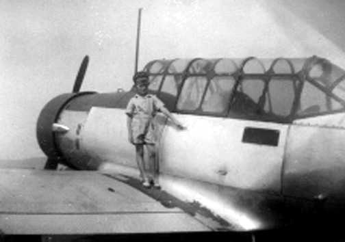
A circa 1948 photo of Allen Smith atop the wing of an Air Force Vultee BT-13 Valiant trainer at Emma Airpark.
Allen recalled, “Another time 6 Air Force pilots circled the airport with what turned out to be trainers.
They finally landed & asked where the terminal was?
Some of us kids told them that the small building was the terminal & the Air Force pilots just laughed.
They quickly departed after calling Asheville taxicabs.
The planes set there & over the years deteriorated never to be flown again.
I can only assume that after the war was over the Air Force just flew these planes into smaller upcoming new airports with no intention of ever moving them.
I do remember it was quite an impressive sight when we heard the planes & could see them all in a long line circling the airport
and every kid within half a mile or so ran to the airport to watch them land & taxi up to where they were first lined up.
Smoke billowing out of the big engines & the noise was unbelievable.
As children this was the closest to the war we could ever hope to get.
I deduced that they probably came from an Air Force base somewhere in the south where pilots were trained to fly & the Air Force just wanted to get rid of them.”
Allen Smith recalled, “The wind sock didn't mean much as all flights had to take off to the east
as there not far to the west was Ben Lippen Mountain & on one occasion I recall a fellow playing with his model airplane
accidentally flew it either over the mountain or into the small mountain.”
Allen continued, “I only recall 2 crashes at Emma Airport.
One, I think a Piper coming in from the east lost control on final
and flipped into the pine trees to the south just missing one of the big oaks I described earlier.
Another one taking off to the west, a small plane used up all the runway
and went off the end of the west end & broke in half.
Eventually my friend Leonard Shuford, Joel Trexler and I cleared an area just off Emma road south of the airport,
hand-made some signs & parked about 50 or 60 cars into the area charging 50 cents each.
Some of the people asked if we would be there to protect them & Leonard assured them we would.
It wasn't our property but we made a few bucks & split when the area was full.”
Allen continued, “The last & final airshow almost got Mr. Josephnson in trouble with the law.
The final act was for a female jumper was to make her first jump... of course the idea was to get the crowd out of the airport.
Again I collected money got my $5 & watched the show from the area where all the pretty girls had gathered with their families.
The announcer built up the show finale & when the woman jumped her parachute didn't open but sailed further south of the airport.
The announcer was pleading with her to pull the rip cord...
he kept shouting as older women in the grandstand were fainting & passing out
and finally he made the statement in an all matter of fact tone that 'THINGS LIKE THAT HAPPEN, YOU CAN'T WIN EM ALL.'
People were running toward the woods across Emma road, and others were laughing realizing the joke,
while ambulances had been called to help those few who were thought to be heart attack victims.
To the best of my memory Joe was not allowed to have anymore air shows.”
No airfield at this location was depicted on the August 1954 USAF Sectional Chart (courtesy of Chris Kennedy) -
either the airfield went through a brief period of closure, or it was simply overlooked as a relatively small airfield.
Allen Smith recalled, “The airport was also used by one of the traveling circuses in the late 1950s.
Also the 800' paved area sprang up when drag racing cars became the big thing in the mid-1950s.
At first they drag raced on the dirt but that did not go over very well for the paying public.
The 800' foot paved part was strictly built for drag racing & a fence was installed to keep the fans from spilling out onto the paved area.
The hangar had been closed down & there were no airplanes there except the remains of the 6 T-6s.
The drag racing in the mid to late-1950s drew large crowds on Saturday nights
but on a very calm Saturday a bolt of lightening out of the blue hit the fence that was in front of the hangar
where boys & men would gather & work on their cars earlier in the day before the afternoon race.
Two boys standing close to the fence were killed instantly as the lightening hit the fence & jumped to each of them
and a number of people were knocked to the ground.”
Allen continued, “I was a tall & skinny 14-year old by then & my 11 year old brother was at the airport.
Petrified that he had been one of the victims I darted out the back door as the news was already on the radio
and ran the 300 yards or so jumping pasture fences as I had to get there as quick as possible.
By then the rain had came in torrents & the lightening seemed to be following the flat 1,800' runway & striking all around.
As I recall I stopped & hugged the bank waiting to make a dash across the airport
and when I started a number of men were yelling at me to stop & lay down.
Hopefully I still had a live brother somewhere in that crowd of people who were there as the storm slowly moved away.
I found my brother among the scared ones & he was not hurt & by then 3 or 4 ambulances was attending to the injured
and the 2 that had been killed were covered & still laying laying where they fell.
That was the end of drag racing at Emma airport & I can only assume that the airport was never used again for any events.
It had a good 20 year plus run & I have many fond memories of EMMA INTERNATIONAL AIRPORT.”
Asheville Airpark was depicted on the 1957 USGS topo map (courtesy of Dallam Oliver-Lee).
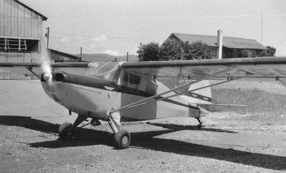
A 1957 photo by James Brown at Emma Airpark of “my Taylorcraft 15A. The office building in the background.”
A 1957 aerial view by James Brown looking west at Emma Airpark, showed the field to have a single northwest/southeast runway & a few hangars along the side.
B.D. McKay pictured in front of his Piper J-5 Cruiser at Emma Airpark in 1958.
Asheville Airpark was not depicted at all on the 1960 USGS topo map (courtesy of Dallam Oliver-Lee).
The January 1961 Charlotte Sectional Chart (courtesy of Chris Kennedy)
depicted "Asheville Airpark" as a private airfield, having an 1,800' turf runway.
The 1961 USGS topo map (courtesy of Dallam Oliver-Lee) depicted Emma Airpark as having a single unpaved northwest/southeast runway,
with a few small buildings along its periphery.
The 1962 AOPA Airport Directory described the Asheville Airpark as having a single 1,800' turf Runway 13/31,
and listed the operator as Joe Josephson.
The field had apparently changed from a private to public-use airfield.
Asheville Airpark, as depicted on the 1964 USGS topo map (courtesy of Dallam Oliver-Lee).
A 10/13/64 USAF aerial photo (courtesy of Dallam Oliver-Lee) depicted Emma Airpark as having a single unpaved northwest/southeast runway,
with a few small buildings along its periphery.
The April 1966 Charlotte Sectional Chart (according to Chris Kennedy)
depicted Asheville Airpark as a public-use airfield with a 1,660' turf runway.
Asheville Airpark was still listed among active airfields in the 1967 NC Airport Directory (according to Paul Cotrufo).
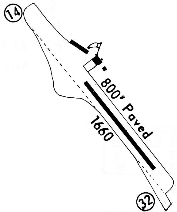
The 1968 Fight Guide (courtesy of Bob Levittan)
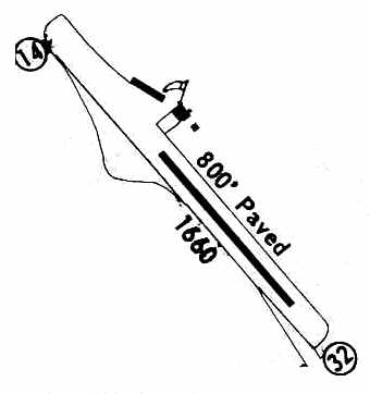
depicted the Asheville Airpark as having a single 1,660' unpaved Runway 14/32, with an inset 800' paved portion.
A total of 3 buildings were depicted on the northeast side of the runway.
Randy White recalled, “I was a kid in the 1960s & we kept 2 of our airplanes at Emma for a while.
We would spend weekends there with other pilots just hanging out.
I had always wondered why only 800' of the runway was paved.
I landed at Emma on my first lesson as a student pilot.
By the time we were hanging around the airpark, the terminal on the hill was a pretty dilapidated house & there was a family living there.”
The 1971 Fight Guide (courtesy of Chris Kennedy)
depicted the Asheville Airpark as having a single 1,660' unpaved Runway 14/32, with an inset 800' paved portion.
A total of 3 buildings were depicted on the northeast side of the runway.
The field was said to be unattended, to be used at "Own risk."
Bill Fishburne recalled, “In 1971, I was a former Green Beret,
fresh out of the Army where I had commanded the USARSO (U.S. Army Southern Operations)
HALO team (High Altitude Low Opening) at Ft. Gulick in the former Canal Zone of Panama.
Being at loose ends & with more than 2,000 jumps under my belt,
I formed a little skydiving company and went around with other former military jumpers
putting on exhibition jumps at picnics, airport openings, air shows, carnivals, race tracks, etc.
On the occasion in question, I was contacted by the Emma Volunteer Fire Department
asking that I make two solo jumps at a fund-raising celebration for the Fire Department at the airport.
So I jumped from a little Cessna 172, landed just fine, repacked, ate a hot dog or two, then went up to jump again.
That jump also went well and I was field packing the parachute when 2 Fire Department volunteers came over
and asked me if I would take a few minutes to meet someone.
I said sure, and they took me over to a little house fronting the airstrip, but lower, at street level.
There I was introduced to a sweet little old lady who told me the greatest story.
Matthew 6:6 says: 'But thou, when thou prayest, enter into thy closet, and when thou hast shut thy door,
pray to thy Father which is in secret; and thy Father which seeth in secret shall reward thee openly.'
The little old lady, hearing that a man would make death-defying parachute jumps that day,
had gone into her closet to pray early in the morning and had remained there
until she heard through the closet walls that the jumper had landed safely from the second jump.
A volunteer from the Fire Department, not having seen her all day, came knocking on her door just after my jump.
She explained where she'd been & he went to get me.
It was one of the most moving & memorable experiences of my career, which included some 3,000 jumps.
We prayed again, together with the firefighters, on her front porch.
I went home a changed man, being somewhat hardened by my military experience,
realizing maybe for the first time that even people who didn't know me could care very deeply about me.
I will never forget the Emma Airstrip.”
Paul Cotrufo recalled, "The former Emma Airpark… was at the edge of town in 1976, when I was there.
It was a north/south runway, with the north end of the runway butting up to Brickyard road.
There never was much too this airport but it sure had a lot of grassroots aviation charm.
There was a large cow barn that was the main hangar. The Asheville Civil Air Patrol kept a couple of L-5s there."
The Asheville Airpark was depicted on the April 1980 Atlanta Sectional Chart (courtesy of Chris Kennedy)
once again as a private airfield, still with a 1,600' unpaved runway.
The Asheville Airpark was evidently closed (for reasons unknown) at some point between 1980-82,
as it was no longer listed among active airfields in the 1982 AOPA Airports USA Directory (courtesy of Ed Drury).
The last photo which has been located showing Emma Airpark still intact was a 4/24/84 USGS aerial photo (courtesy of Dallam Oliver-Lee).
Allen Smith recalled, “The terminal was converted into a small house
rented as such to a fine family who had moved to the area & I became friends with the 2 older children.
Later the grounds were used for turkey shoots as they were called.
Later as the area deteriorated, the gate & fence were down, and the big oak tree became a special parking place for many a young couple.”
A 5/27/88 USGS aerial photo (courtesy of Dallam Oliver-Lee) showed the Emma Airpark site had been cleared,
presumably in preparation for new construction.
A 3/21/94 USGS aerial photo (courtesy of Dallam Oliver-Lee) showed several large industrial buildings had been constructed,
removing any trace of Emma Airpark.
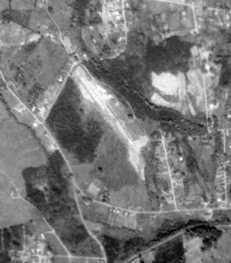
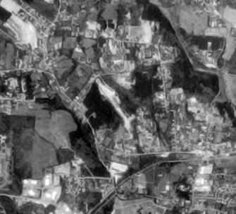
A 10/20/10 aerial photo (courtesy of Dallam Oliver-Lee) showed no obvious trace remaining of Emma Airpark,
but one former hangar remains at the top-center of the photo.
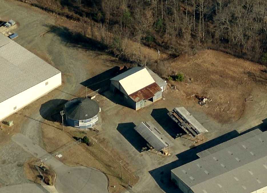
A circa 2010 aerial view looking north at the last trace which remains of Emma Airpark: the circa 1940s hangar.
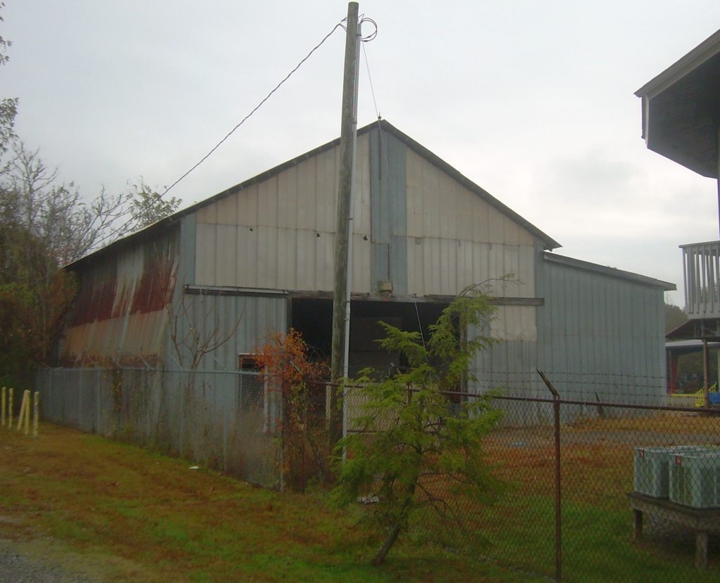
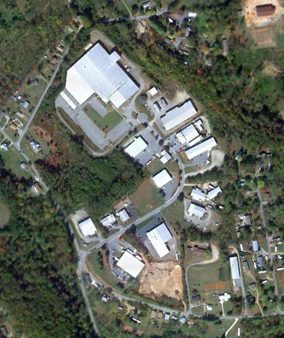
A 2013 photo looking east at the last trace which remains of Emma Airpark: the circa 1940s hangar.
A local resident reported in 2013, “I work right beside the old Emma Airpark.
I looked at [the] photos of the old hanger, and surprisingly it still exists here on Westside Drive.
It still looks identical today to the [older] photos, except that the main hangar door has been narrowed with metal panels, so it doesn’t open that wide anymore.”
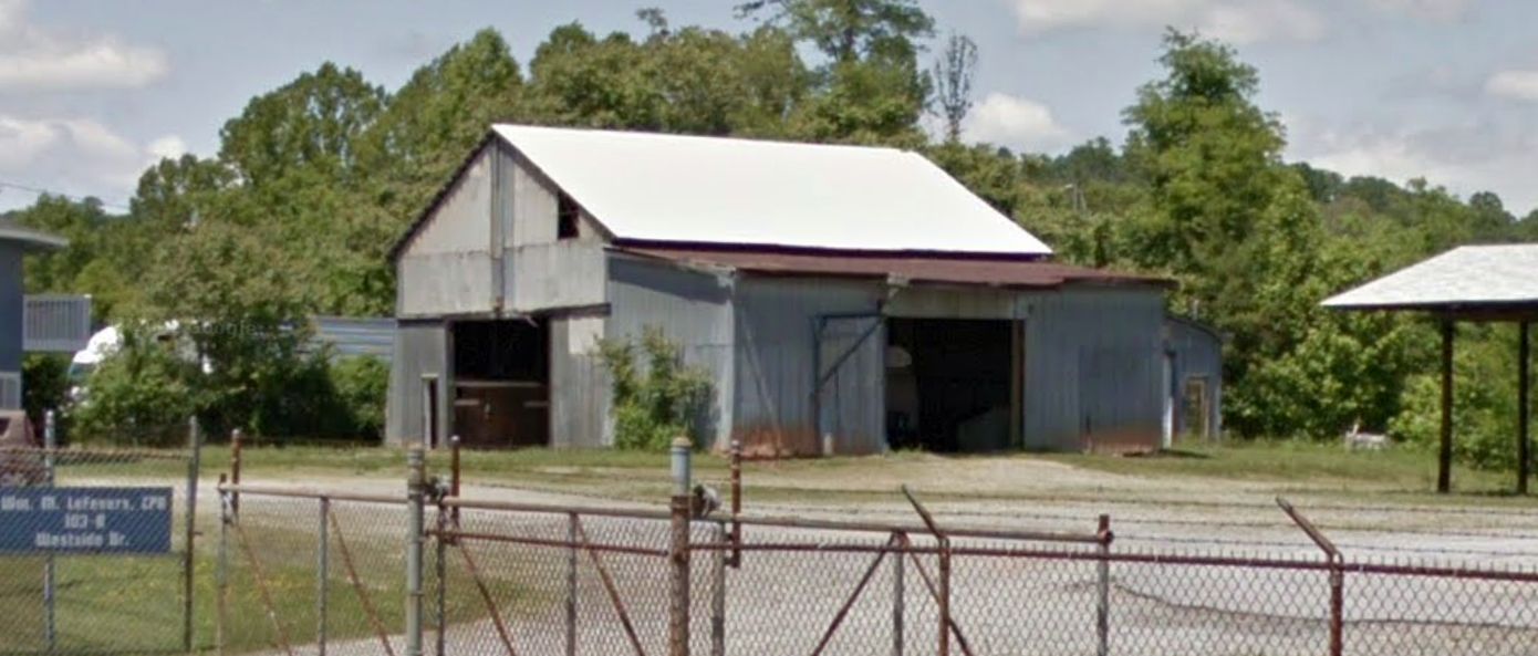
A 2019 photo looking north at the last trace which remains of Emma Airpark: the circa 1940s hangar.
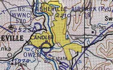
The site of Asheville Airpark is located at the eastern terminus of Airpark Road, appropriately enough.
Thanks to Paul Cotrufo for pointing out this airfield.
____________________________________________________
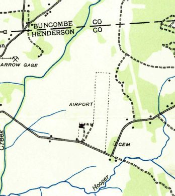
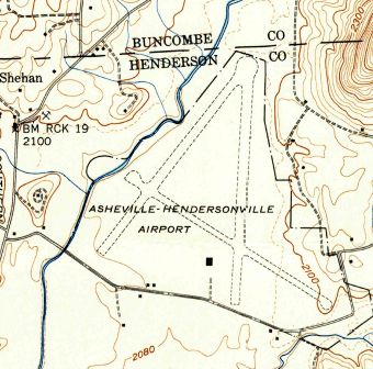
Asheville-Hendersonville Airport, Fletcher, NC
35.44, -82.48 (East of Asheville Regional Airport, NC)
Asheville-Hendersonville Airport, as depicted on the May 1935 Charlotte Sectional Chart.
The original Municipal Airport for the town of Asheville was located southeast of the town.
The date of construction of the Asheville-Hendersonville Airport has not been determined.
The earliest reference to the Asheville-Hendersonville Airport which has been located
was in the Airport Directory Company's 1933 Airports Directory (courtesy of Chris Kennedy).
It described Asheville-Hendersonville as being a 50-acre field, having 2 "silt-loam" runways in an L-shape,
measuring 3,100' north/south & 1,200' east/west.
A hangar was said to have "Asheville Airport" painted on the roof.
The earliest depiction of the Asheville-Hendersonville Airport which has been located
was on the on the May 1935 Charlotte Sectional Chart.
It depicted Asheville-Hendersonville as a commercial/municipal airport.
The 1936 USGS topo map (courtesy of Dallam Oliver-Lee)
depicted Asheville-Hendersonville Airport as a single unpaved north/south runway,
labeled simply as “Airport”, with a few small buildings on the southwest side.
The earliest photo of the Asheville-Hendersonville Airport which has been located
was an undated aerial view in the Airport Directory Company's 1937 Airports Directory (courtesy of Bob Rambo).
Asheville-Hendersonville had evidently gained a 2nd runway at some point between 1936-37,
as the directory described it as having 2 "silt-loam" runways, with the longest being a 3,100' north/south strip.
A hangar was said to have "Asheville Airport" painted on the roof.
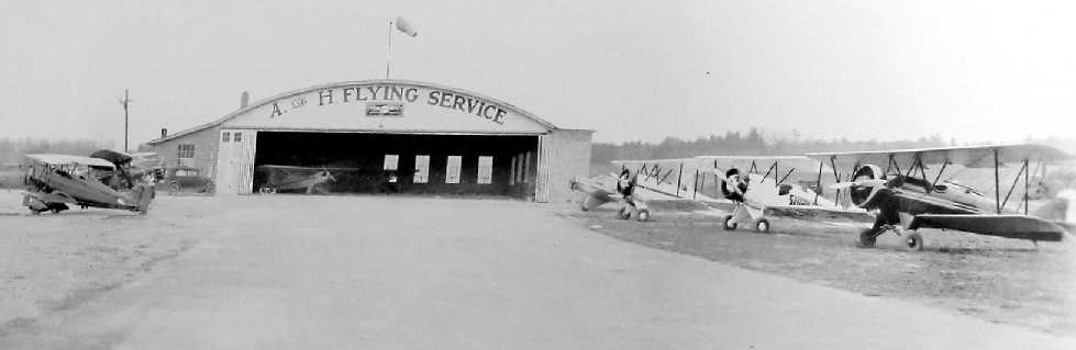
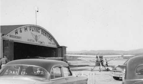
A photo (believed to be 1937) showing 8 aircraft around & inside the A&H Flying Service hangar at Asheville-Hendersonville Airport (courtesy of Frank Blazich).
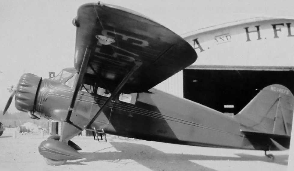
A photo (believed to be 1937) of a Stinson Reliant in front of the A&H Flying Service hangar at Asheville-Hendersonville Airport (courtesy of Frank Blazich).
According to Mark Hess, “Mark Reed... was the Manager of the Asheville-Henderson Airport before WWII.”
The Asheville-Hendersonville Airport was described in a 1940 U.S. Airport Directory (according to Paul Cotrufo)
as having 2 runways: a 2,200' east/west paved strip & a 3,200' north/south turf strip.
Asheville-Hendersonville had evidently gained a 3rd runway at some point between 1940-42,
as the 1942 USGS topo map (courtesy of Dallam Oliver-Lee) depicted the field as having 3 unpaved runways.
The April 1944 US Army/Navy Directory of Airfields (courtesy of Ken Mercer)
described the Asheville-Hendersonville Airport as having a 4,000' hard-surface runway,
and indicated that both Army & Navy flight operations were conducted from the field.
According to Hillis "Al" Cunliffe, commercial airline service at the Asheville-Hendersonville Airport
"began after WW2 & was provided by Delta Airlines, Capital Airlines, and Piedmont Airlines.
Asheville was one of the enroute stops on Piedmont's inaugural service from Wilmington, NC to Cincinnati, OH."
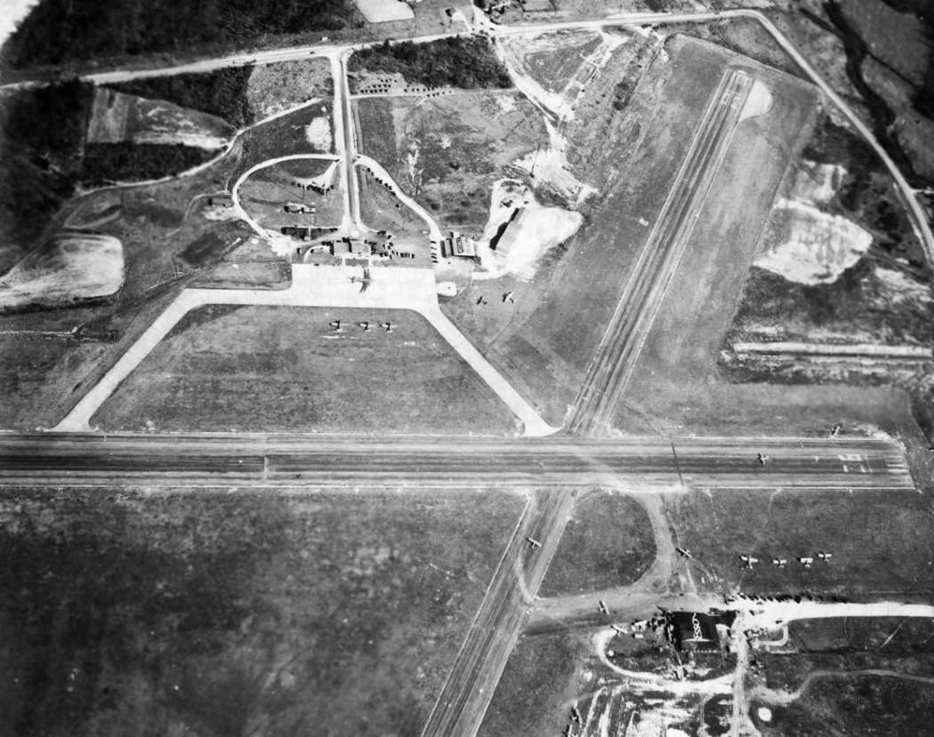
A March 1950 aerial view looking east at Asheville/Hendersonville (from the Pack Memorial Library, via Dallam Oliver-Lee).
Two of the 3 paved runways were visible, along with a DC-3 in front of the passenger terminal on the east side,
and several small planes parked around a hangar with “Esso” painted on the roof at the bottom-right.
A 3/12/50 photo of Western North Carolina’s first Wing Scout troop at the Asheville-Hendersonville Airport (from the Pack Memorial Library, via Dallam Oliver-Lee).
The scouts were receiving their pins in a ceremony, with their troop leader Anne Shields (2nd from right) who trained fighter pilots during World War II.
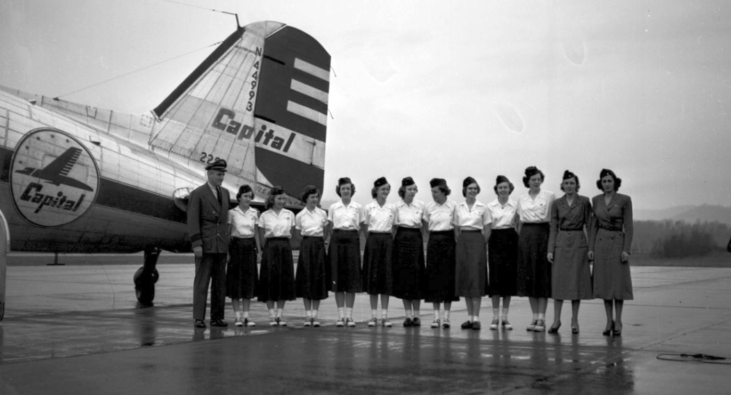
Note the Capital Airlines DC-3 in the background.
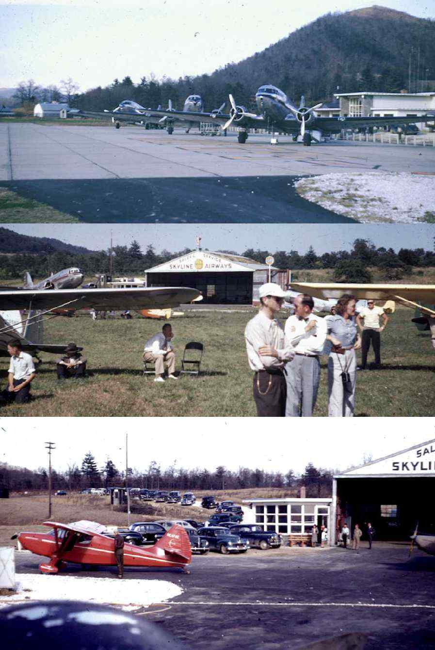
A series of 3 circa 1950s photos of 3 DC-3s in front of the Asheville Hendersonville Airport terminal,
and other aircraft in front of the Skyline Airways hangar (courtesy of Mike Whitt).
Mike reported, “The photos were sent to me by the daughter of the man who was the FBO at this airport.”
The last dated photos which have been located showing the Asheville-Henderson Airport still in operation was a series of 1954 photos by James Brown.
This photo shows a Piper in front of the FBO hangar.
James recalled, “I had just gotten my drivers license & I would drive out there to watch the planes.
I took my first plane ride there in a J-3 Cub, we flew out to Asheville & back, it was the first thrill of my life.”
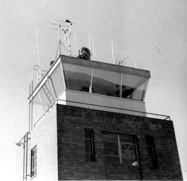
A 1954 photo by James Brown of Asheville-Henderson's “control tower which was just to the left of the hangar.”
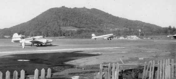
A 1954 photo by James Brown of Asheville-Henderson, showing “a Piper Apache & a Delta DC-3.
The DC-3 airliners that served the airport were Capitol, Delta, and Piedmont Airlines.”
The Asheville-Hendersonville Airport also had some use in testing of ejection seats.
The Stencel Aeronautical Research Corporation (which produced aircraft ejection seats)
had a plant "located about 2 miles from the Asheville Airport
on the main access road from Route 25", according to Hillis "Al" Cunliffe.
"My father worked for the Stencel organization from the day it opened it's doors in 1958 until his retirement in 1982.
He was one of the original dozen people hired by the company's founder, Fred Stencel.
He maintained the 3 different aircraft the company operated to support their R&D efforts."
The airplanes were kept the Asheville Regional Airport.
Over a period of several years they owned an SNJ-5, a TBM-3 and a Douglas A-26.
The SNJ-5 & TBM were operated at the same time,
but the A-26 was the last airplane they had, for only a year or so."
The 1960 Jeppesen Airway Manual (courtesy of Chris Kennedy)
depicted the Asheville Hendersonville Airport as having 3 paved runways (with the longest being the 4,079' Runway 4/22),
as well as a taxiway leading to a ramp on the east side of the field,
around which were clustered a large number of small buildings & a tower (a control tower?).
In January 1961 the new Asheville Airport (today's Asheville Regional Airport) was opened 3 miles to the west.
The new airport featured a much longer runway, which would be more compatible with modern airline flights.
Both the new & old Asheville Airports were depicted
on the January 1961 Charlotte Sectional Chart (courtesy of Chris Kennedy).
Asheville-Henderson Airport was described as having a 4,100' hard-surface runway.
The Asheville-Hendersonville Airport was closed at some point between 1961-63,
as it was labeled "Abandoned airport" on the May 1963 Charlotte Sectional Chart (courtesy of Chris Kennedy).
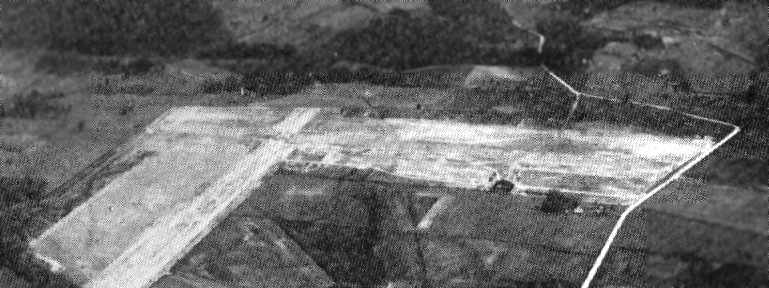
The last photo which has been located showing Asheville-Hendersonville Airport still intact was a 9/24/64 USAF aerial view (courtesy of Dallam Oliver-Lee).
All 3 runways were marked with closed-runway “X” symbols, but the field appeared to remain otherwise intact.
No aircraft were visible on the field.
The 1965 USGS topo map (courtesy of Dallam Oliver-Lee) labeled the field as “Asheville-Hendersonville Airport (abandoned)”.
Paul Cotrufo recalled, "When I visited that old airport in 1973,
it was 'way out in the boonies', no sign of urban development anywhere, horse & farm country."
Randy White recalled, “The old Asheville Airport... As a kid the old airport was already closed & I belonged to a radio-control model [airplane] club that used it to fly off of it for several years.
My uncle, L.A. White, bought most of the property & turned it into an industrial park & a shop for his trucking business.
He loved trains since he and my father were engineers during the war.
He installed about a mile of track on the airport property & put an locomotive on it. He used to take us for rides up & down the track.
He later turned that into another business, building warehouses with rail access.
My uncle wanted to learn to fly so he turned part of the old airport into a grass strip & bought a Cessna 150.
After a couple of lessons he discovered that he had an inner ear problem that would not allow him to fly.
The 2 instructors that taught my parents to fly eventually went to work for Piedmont airlines.
My uncle built them a hangar each & an underground fuel pit there at his grass runway.”
According to Hillis "Al" Cunliffe, "The old airport was used as a drag strip for several years, then became an industrial park."
A 5/20/76 USGS aerial photo (courtesy of Dallam Oliver-Lee) showed that a large building had been built over Runway 4/22 at some point between 1965-76,
along with another large building adjacent to the south side of Runway 12/30.
The 1994 USGS aerial photo showed that the outline of 3 former runways were still recognizable at the site of the original airport,
but additional industrial buildings had been built on the north end of Runway 18.
Recent street maps label the property of the former airport as the Cane Creek Industrial Park.
Ironically, as of 2004, a small portion of the site of Asheville-Hendersonville Airport still has some aviation use.
The Cane Creek Airport is listed as of 2004 in the Airport/Facility Directory as a private airfield.
It consists of a 2,680' turf Runway 4/22,
visible immediately adjacent to the northwest side of the large industrial building in the above aerial photo.
The owner is listed as L. A. White, and a total of 7 aircraft are listed as being based at the field,
including 5 single engine aircraft & 2 gliders.
Several small Quonset-hut style buildings just north of the large building may serve as hangars for the field.
Thanks to Hillis "Al" Cunliffe for pointing out this reuse of the old field.
A circa 2006 aerial view looking north at the remains of 2 runways & the taxiway leading to the former ramp,
now covered by an industrial building.
A 10/20/10 aerial photo (courtesy of Dallam Oliver-Lee) showed the outline of 3 former runways were still recognizable at the site of the original airport.
Note the grass runway of the Cane Creek Airport just northwest of the large white building at the center of the photo.
A 5/21/18 photo by Liz Spence of “the only place I could find anything left from the old airport. It is the southwestern side of the old airport.
There is a path to it from the parking lot of an industrial building by some train tracks through a grove of trees.
There is a narrower strip of asphalt over what looks to be very old but wider asphalt.”
She also reported of the grass runway on the northwest side of the site (previously designated as Cane Creek Airport),
“The grass airstrip... It is all fenced in & overgrown. Nobody seems to be using it.”
The site of the Asheville-Hendersonville Airport is located north of the intersection of Mills Gap Road & L A White Road.
Thanks to Paul Cotrufo for pointing out this airfield.
____________________________________________________
Lake Logan Airfield, Sunburst, NC
35.4, -82.93 (Southwest of Asheville, NC)
The Lake Logan Airfield, as depicted on the 1979 USGS topo map.
Photo of the airfield while in use has not been located.
The date of construction of this former small private airfield has not been determined, as well as its actual name.
It was not depicted at all on on the 1941 USGS topo map (according to William Stephens)
or on Sectional Aeronautical Charts from 1948, 1954, 1961, 1966, 1974, 1975, or 1976 (according to Chris Kennedy).
The earliest depiction of this airfield which has been located was on the 1979 USGS topo map.
It depicted a single 3,600' runway, which actually was somewhat curved as it followed the narrow slice of land
in between Route 215 & the west bank of the Pigeon River.
The airfield was not labeled at all.
Spurgeon McDade recalled, "Champion Paper had a company camp/retreat near Sunburst,
at Lake Logan (lakes, cabins, hunting lodges), and the remains of a concrete landing strip is still there."
William Stephens recalled, "Champion International paper company (since absorbed by International Paper) had a sort of fishing retreat called Lake Logan.
At some point they built a very narrow paved strip with a sort of cul-de-sac at one end for turning around.
It was completely surrounded by huge pine trees,
and my father said the company pilot threatened to quit if he had to keep flying in there, so that one went by the wayside."
According to an 11/13/24 Mountaineer article (courtesy of David Bishop),
Lake Logan was “the runway where Champion International once flew in special guests, including Richard Nixon, George W. Bush and evangelist Billy Graham.”
The date of abandonment of this airfield has not been determined.
No airfield at this location was depicted on the 1980 Sectional Aeronautical Chart (according to Chris Kennedy).
A 3/24/86 USGS aerial photo (courtesy of Dallam Oliver-Lee) appeared to show the Lake Logan runway.

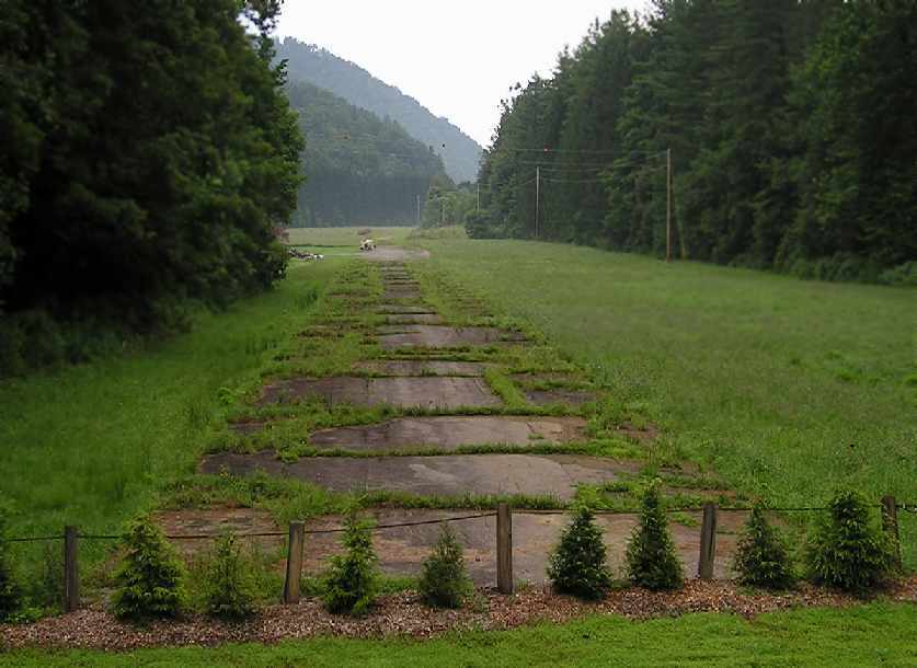
As seen in a 1995 USGS aerial view looking northwest, Lake Logan's single concrete runway was still recognizable.
A small group of buildings was located on the west side of the field, but they did not appear to be big enough to be hangars.
A 2004 photo by Rod Wright, looking north at the abandoned runway at Lake Logan.
"At this end of the runway, a parking area for a boating access ramp
has been built by the North Carolina Wildlife Resource Commission [behind the photographer].
Note the obstruction warning balls on the power line.
At least the power company figures somebody may try to land there."
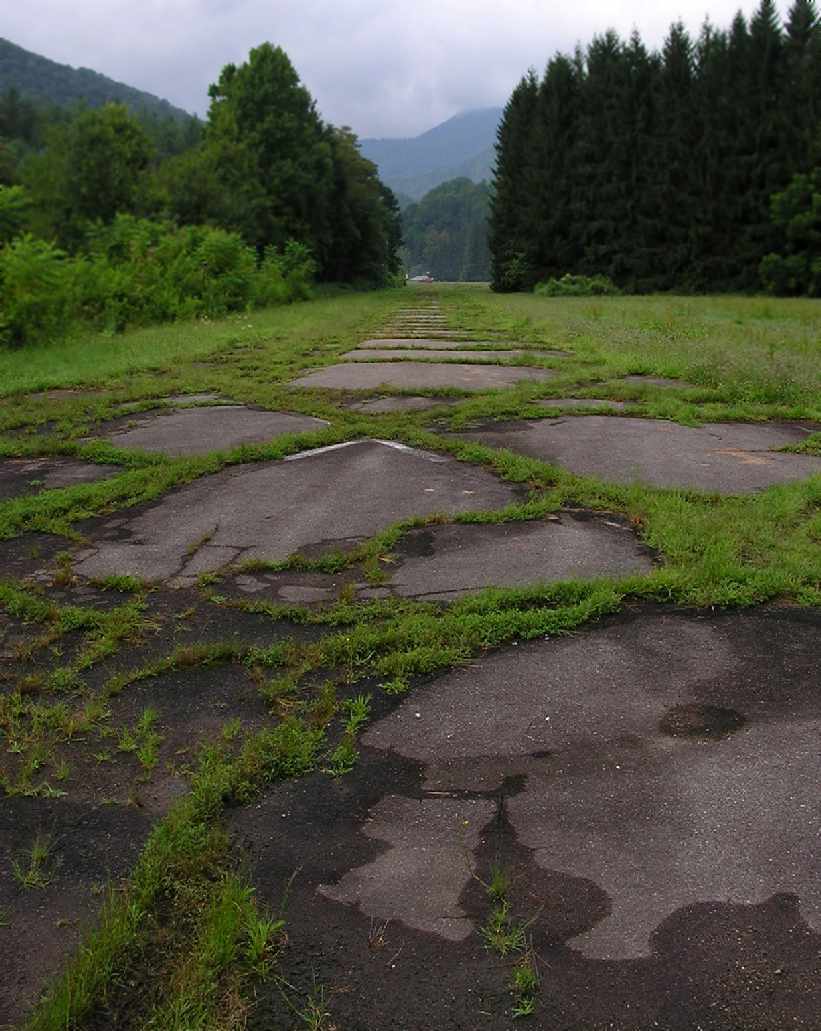
A 2004 photo by Rod Wright, looking south along the abandoned runway at Lake Logan.
"Note remains of asphalt runway with closed 'X'."
A 2004 photo by Rod Wright, looking south along the abandoned runway at Lake Logan.
"Note the buildings in the distance. The runway curves to the left before the buildings."
A 2015 aerial view looking northwest showed that the southern & northern ends of the Lake Logan runway pavement remained intact,
but the middle portion of the runway had been eaten away by the westward migration of the adjacent Pigeon River.
According to an 11/13/24 Mountaineer article (courtesy of David Bishop), Hurricane Helene removed the last traces of the Lake Logan Airfield:
“Thirteen inches of rain created a 'tree highway' & wiped out the runway.
While the runway was an interesting historic footnote, long-term plans had called for its removal.”
The site of the Lake Logan Airfield is located on the east side of Route 215, just south of Lake Logan.
Thanks to Spurgeon McDade for pointing out this airfield.
____________________________________________________
Camp Summit Airfield, Cedar Mountain, NC
35.17, -82.61 (West of Charlotte, NC)
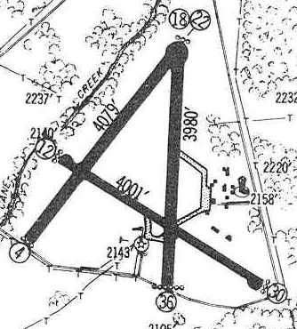
The Camp Summit Airfield, as depicted on the 1965 USGS topo map (courtesy of Dallam Oliver-Lee).
The Camp Summit airfield was apparently built at some point between 1964-65,
as it wasn't depicted on a 10/7/64 USAF aerial photo (courtesy of Dallam Oliver-Lee).
The earliest depiction which has been located of the Camp Summit airfield was on the 1965 USGS topo map (courtesy of Dallam Oliver-Lee).
It depicted a single paved northwest/southeast runway, labeled simply as "Landing Strip".
According to the DuPont State Forest (which eventually took over the property),
the Camp Summit airfield was built as part of a boys & girls camp.
The Camp Summit airfield was not depicted on the October 1968 Charlotte Sectional Chart.
The earliest photo which has been located of the Camp Summit Airfield was a 3/27/89 USGS aerial view (courtesy of Dallam Oliver-Lee).
It depicted Camp Summit as having a single asphalt 3,000' runway, with a single hangar west of the runway.
A 1994 USGS aerial view looking northeast depicted the Camp Summit airfield as having a single asphalt 3,000' runway.
The airfield had evidently been closed at some point between 1965-94, as the runway was painted with closed runway "X" markings.
A single hangar sat west of the runway.
A circa 2000s view of the Camp Summit runway, with Mount Pisgah visible in the background.
On the 2002 aeronautical chart, the airfield doesn't show up at all (even as an abandoned airfield).
The Camp Summit airfield was filmed for the 2012 movie The Hunger Games,
and a train was superimposed via CGI going down the middle of the runway.
A 2015 aerial view looking northeast showed the Camp Summit airfield remained intact, with closed-runway “X” symbols painted along the runway.
The Camp Summit airfield is located on the west side of Conservation Road, north of Blue Ridge Road.
____________________________________________________
Or if you prefer to contact me directly concerning a contribution (for a mailing address to send a check),
please contact me at: paulandterryfreeman@gmail.com
If you enjoy this web site, please support it with a financial contribution.
____________________________________________________
This site covers airfields in all 50 states.