Abandoned & Little-Known Airfields:
Southeastern North Carolina
© 2002, © 2026 by Paul Freeman. Revised 2/8/26.
This site covers airfields in all 50 states: Click here for the site's main menu.
____________________________________________________
Please consider a financial contribution to support the continued growth & operation of this site.
Burgaw Airport (revised 2/23/24) - Blue Bird MCEAF (revised 2/23/24) - Camp Davis AAF / Hollyridge AAF / Camp Davis MCOLF (revised 8/29/24)
Fort Fisher Army Airfield (revised 2/23/24) - Jacksonville Airport (revised 2/8/26) - White Oak Airport / Piney Green International Airport (revised 3/3/22)
____________________________________________________
Fort Fisher Army Airfield, Fort Fisher, NC
33.97, -77.92 (South of Wilmington, NC)
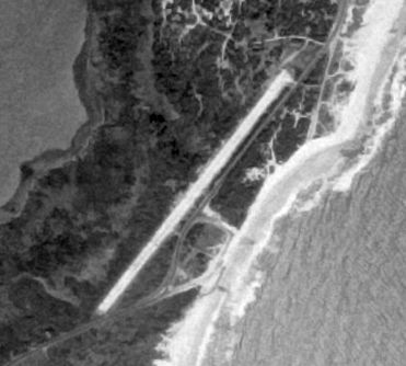
A 1/1/58 USGS aerial view of Fort Fisher Army Airfield.
Fort Fisher was a Civil War era Confederate fort along the Atlantic coast.
In late December 1940, Camp Davis was built several miles to the north as an Army anti-aircraft artillery training facility.
The Fort Fisher property was used as the main target range for Camp Davis and the installation was given the name Fort Fisher Army Air Field.
Because of the new range's prominence, it was deemed necessary to make the range a self-sustaining post.
This called for the construction of 48 frame buildings, 316 tent frames, showers and latrines, mess halls, warehouses,
radio and meteorological stations, a post exchange, photo lab, recreation hall, outdoor theater, guardhouse, infirmary, and an administration building.
In addition to these facilities, the site featured a 10,000-gallon water storage tank, a motor pool, a large parade ground, and 3 steel observation towers along the beach.
According to Thomas Page, “I think there were 8 anti-aircraft gun emplacements.”
One of the more prominent features of the range was a 2,500' unpaved runway.
From a historical standpoint it was unfortunate the runway was built right through a section of the earthworks for the fort's land face, known as Shepard's Battery.
The Army was well aware of the historical significance of the old fort, but the necessities of the war outweighed historic preservation.
The Fort Fisher Army Airfield was not depicted on the 1942/44/45 Savannah Sectional Charts.
In 1944 the anti-aircraft training facility was transferred to another base and Camp Davis & Fort Fisher AAF were closed.
At the time of its closure, Fort Fisher AAF had grown to include an 80-seat cafeteria, a 350-bed hospital and dental clinic, and covered an area of several hundred acres.
The Fort Fisher runway was not depicted on the 1946 USGS topo map.
In 1955 a property to the north of the airfield became the site of Fort Fisher Air Force Station, an air defense radar installation.
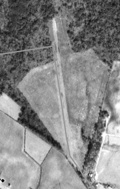
The earliest depiction which has been located of the Fort Fisher runway was a 1/1/58 USGS aerial view.
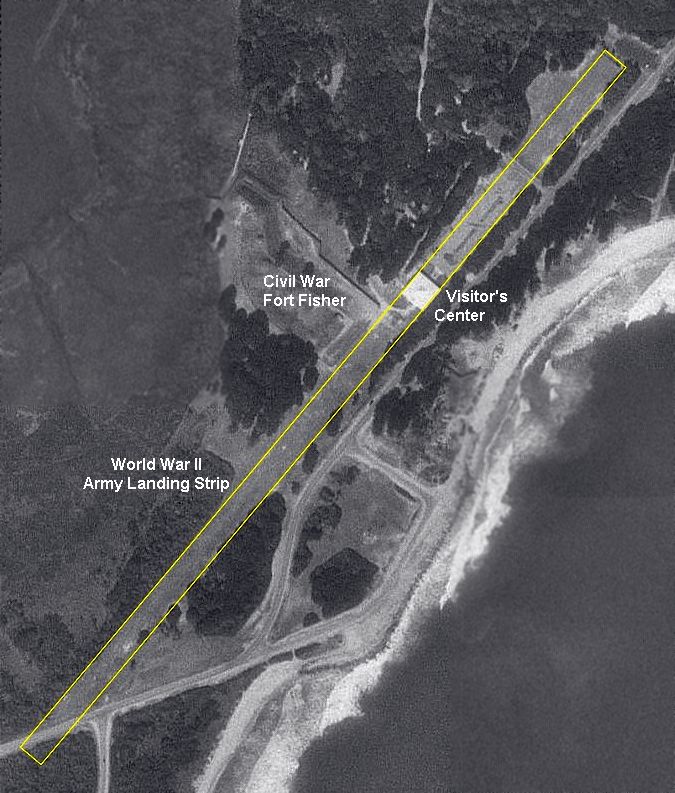
The 1997 USGS aerial photo annotated by Thomas Page to show the location of the Fort Fisher runway.
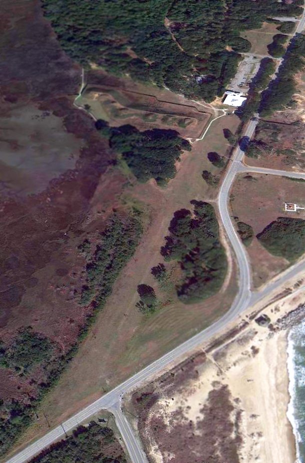
A 1/3/13 aerial view looking north showed the outline of the Fort Fisher runway remained recognizable.
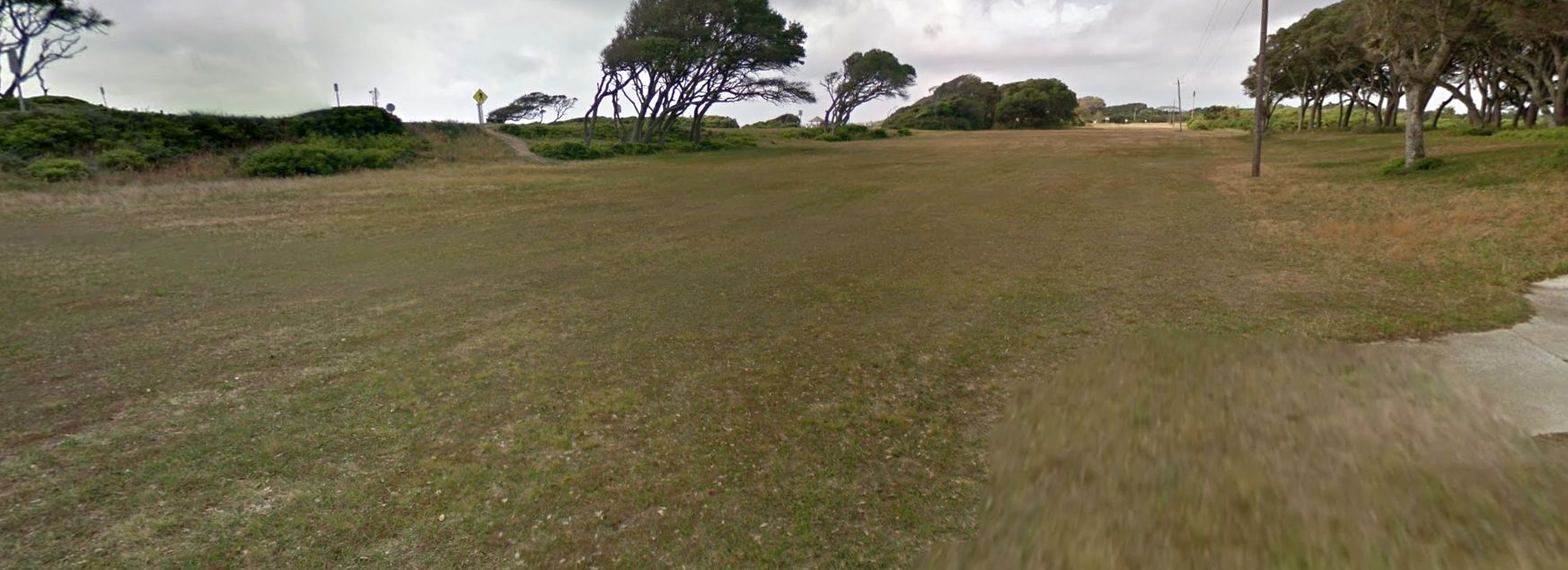
A 2016 photo looking southwest along the remains of the Fort Fisher runway.
The site of Fort Fisher AAF is located north of the intersection of Fort Fisher Boulevard & Battle Acre Road.
____________________________________________________
34.55, -77.95 (Southeast of Raleigh, NC)
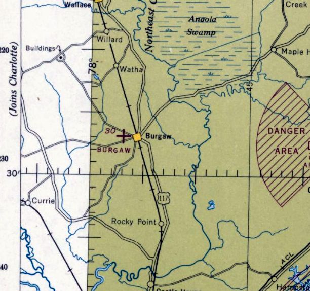
Burgaw Airport, as depicted on the September 1944 Norfolk Sectional Chart.
Photo of the airport while open has not been located.
Burgaw Airport was not yet depicted on the May 1944 Norfolk Sectional Chart.
According to a document provided by Mark Hess, “The Burgaw Airport Commission was organized on 6/20/44, with Senator Roy Rowe, Chairman, J.R. Lewis, Secretary & Treasurer.
Members: J.F. Bardshaw, E.N. Pearsall, C.F. Mallard, Leon Corbett as Consulting Attorney. The airport was inspected & opened for business 10/11/44.”
The earliest depiction which has been located of the Burgaw Airport was on the September 1944 Norfolk Sectional Chart, which depicted Burgaw as an auxiliary airfield.
The 1945 AAF Airfield Directory (courtesy of Scott Murdock) described Burgaw Airport
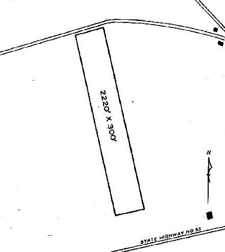
as a 76 acre irregularly-shaped property containing a single 2,200' sod NNW/SSE runway.
The field was not said to have any hangars, and to be owned & operated by private interests.
According to a document provided by Mark Hess,
Burgaw Airport “has developed into a Government School for training G.I.'s in aviation.”
According to Mark Hess, “The Airport hangar was off a distance from the highway, 1944 to 1970s.”
Burgaw Airport may have been closed by 1953, as it was no longer depicted on the 1953 USGS topo map,
The last aeronautical chart depiction which has been located of the Burgaw Airport was on the January 1957 Charlotte Sectional Chart.
It depicted Burgaw as having a 2,200' unpaved runway.
Burgaw Airport was evidently closed (for reasons unknown) by 1960,
as it was no longer depicted on the July 1960 Charlotte Sectional Chart.
According to the Pender County Library, “The airport closed in the 1970s.”
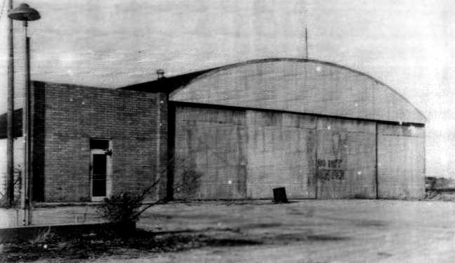
A 1979 photo of the former Burgaw Airport hangar (courtesy of Mark Hess).
According to the Pender County Library, “Budd Ramsey built the brick office beside it.”
The 1993 & 1999 USGS aerial photos depicted the site of Burgaw Airport as an open farm field,
with the hangar having been possibly relocated to the southeast corner of the site.
A 2004 aerial photo showed that residential construction had covered the the southwest part of the former Burgaw Airport.
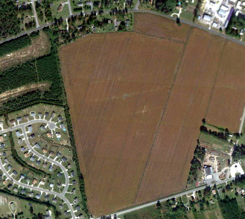
A 10/23/10 aerial view showed the majority of the former Burgaw Airport remaining an open farm field.
The former hangar was visible at the bottom-right, after having been possibly relocated.
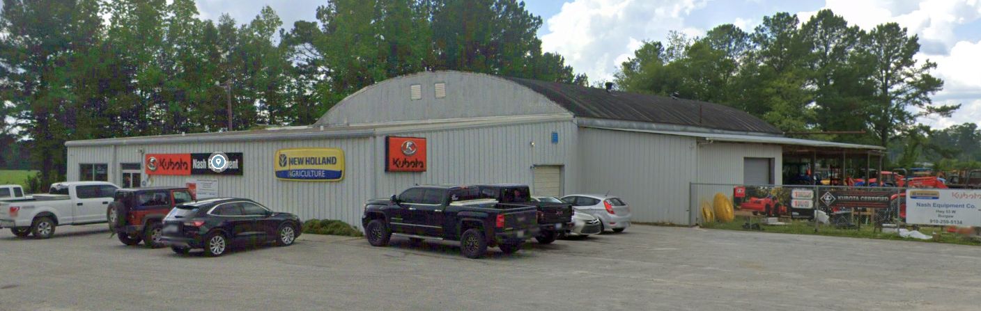
A 2023 photo looking northwest at the former Burgaw Airport hangar, reused by the Nash Equipment company.
The site of Burgaw Airport is located northeast of the intersection of Route 53 & Teabriar Street.
____________________________________________________
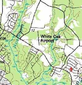
White Oak Airport / Piney Green International Airport, Jacksonville, NC
34.77, -77.35 (North of Camp Lejune, NC)
White Oak Airport, as depicted on a 1956 aerial view (courtesy of Kelly Murray).
Note, the diagonal line running along the runway was an overlay, not part of the photo.
The date of construction of this small private airfield has not been determined.
No airfield at this location was depicted on 1945/61/65/72 Sectional Charts.
The earliest depiction of White Oak Airport which has been located was a 1956 aerial view (courtesy of Kelly Murray).
It depicted a single unpaved northwest/southeast runway.
There did not appear to be any buildings on the field, nor any planes.
A 1957 aerial view (courtesy of Kelly Murray) depicted White Oak Airport in an unchanged manner.
A 1964 aerial view (courtesy of Kelly Murray) showed that White Oak Airport had gained a small building (a hangar?) on the southeast side at some point between 1957-64.
The earliest depiction which has been located showing aircraft at White Oak Airport was a 1974 aerial view (courtesy of Kelly Murray).
It depicted 3 or 4 light single-engine aircraft parked on the southeast side.
Note, the diagonal line running along the runway was an overlay, not part of the photo.
White Oak Airport was not listed in the 1976 AOPA Airports USA Directory (according to Chris Kennedy),
or depicted on the November 1976 CG-21 World Aeronautical Chart (according to Chris Kennedy).
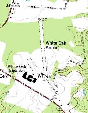
The earliest topo map depiction which has been located of White Oak Airport was on the 1977 USGS topo map.
It depicted the field as having a single 2,400' unpaved north/south runway.
A single small building was depicted on the southeast side of the runway.
Richard Stockman recalled, “The White Oak / Piney Green Airport...
several of the planes from the Jacksonville airport ended up there when they closed [the original Jacksonville Airport].
The owners did not want to pay the high storage cost at the new Albert Ellis Airport & the fact that most of the owners lived in that area.
That field started out as a fueling point for crop dusters & just grew from that.
During the week someone was always at the office to man the radio for incoming flights
and Mr. Blake also had a radio at his house so a pilot could call ahead of time on the weekend & he would go to the field to help.
He also lived in Long Acres as I did so he wasn’t far from the field.
There was 2 of the Ercoupes at the field & I had about 15 hours between the two.”
Former Jacksonville resident Maxine Frisbee recalled of White Oak Airport, "It was open in the 1970s & was a private airstrip.
It was located off of Piney Green Road behind White Oak High School."
The 1982 AOPA Airports USA Directory (courtesy of Ed Drury)
listed the field as a private airfield, humorously named “Piney Green International”.
Sheldon Daitch recalled, “White Oak & Piney Green International were indeed the same place.
I got my private rating at the John LeJeune Flying Club at New River Air Station mid-1970s.
I am not sure we ever called it White Oak, and I suspect the term Piney Green International was more a joke than a real name for the place.
Piney Green Road is the road along the school. I am almost sure we did some landings there.
Dr. Russell Barnes had a Bonanza based at the field. 'Doc' regularly flew out of field.
I remember one trip, maybe 1977, when I went with him up to RDU in the Bonanza.
Although the field was not lighted, it was used for night landings.
There were some reflectors on the approach end of the field, nearest Piney Green Road, and maybe some more along the side & perhaps the end.
Perhaps I was too new to flying to figure a night landing & PGI might not be the most appropriate way to end a flight!”
Maxine Frisbee recalled of White Oak Airport, "It closed in the early 1980s I believe not long after my cousin & a fellow pilot crashed & died there.
I believe that it was determined that the gas that was provided had the wrong mixture.
They gained enough altitude to get off the ground but crashed into one of the high school greenhouses."
White Oak Airport was no longer depicted on the August 1988 Charlotte Sectional Chart (courtesy of Ron Plante).
White Oak Airport was still depicted on the 1991 USGS topo map, even though it may have been closed by that point.
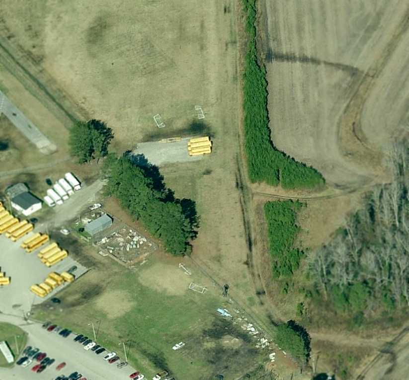
A 1993 USGS aerial view looking northeast showed the White Oak Airport runway appeared to remain completely intact, and there appeared to be a small building just southeast of the runway.
Maxine Frisbee reported in 2004, "I am sure that the old runway might be there because it led out into tobacco fields that are still farmed today."
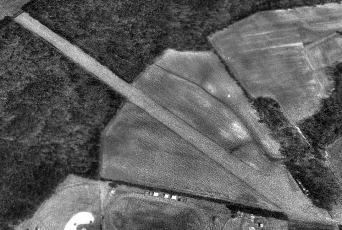
A circa 2008-2010 aerial view looking north along the south end of the White Oak runway
shows the runway to remain clear, but the small building at the southeast end was apparently removed at some point between 2007-2010.
A 2015 aerial view looking north at the site of White Oak Airport showed the runway alignment was still recognizable.
The site of White Oak Airport is located northeast of the intersection of Piney Green Road & Halltown Road.
____________________________________________________
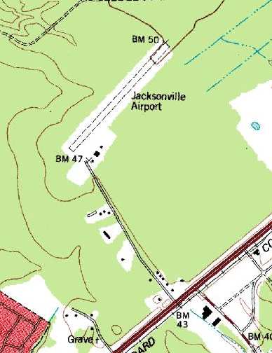
Jacksonville Airport, Jacksonville, NC
34.786, -77.399 (North of Camp Lejune, NC
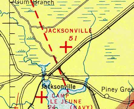
Jacksonville Airport, as depicted on the April 1946 Norfolk Sectional Chart (courtesy of Chris Kennedy).
The original airport for the town of Jacksonville was located to the northeast of the town.
Jacksonville Airport was apparently built at some point between 1945-46
(like hundreds of other small airports across the U.S., in the post-WW2 airport boom),
as it was not depicted on the 1943 USGS topo map or the 1945 Norfolk Sectional Chart (courtesy of John Voss).
The earliest depiction of the Jacksonville Airport which has been located was on the April 1946 Norfolk Sectional Chart (courtesy of Chris Kennedy).
It depicted Jacksonville as an auxiliary airfield.
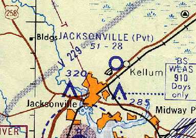
The January 1956 Norfolk Sectional Chart (according to Chris Kennedy) depicted Jacksonville as a public-use airport.
Richard Stockman recalled, “The Jacksonville airfield, run by Allen Blake, was my airport.
I grew up about 1 mile from the airport through the woods to the southwest of the runway.
Mr. Blake had a son Chris & we spent many days at the airport.
I moved many planes from tiedown to the fuel pad to prep for flight or cleaning a plane just in from a trip before going to tiedown.
Some pilots preferred having their plane fueled before parking & some would wait till they were going someplace.
I would help the on-site mechanic with repairs from time to time. For doing this Mr. Blake would give me flying lessons.
For a time I would also go with friends from the airfield to go sky diving, I did 9 jumps (5 static, 4 free-fall),
I was truly too young to do this but my parents gave their blessing & things were overlooked for a time.
Weldon Simpson had a Cessna Skymaster which he would fly for the skydiving once in a while.
Most time we used a Cessna 172. Dr. Barns had a Mooney, an M20F Exec. I remember it was 6 passenger & would really haul.
He sold that back to Mr. Blake & bought a Piper Aztec.
When Dr. Barns bought the plane he had to go to Raleigh & then fly it back to Jacksonville, I remember the trip well.
That was the first time I had been in a multi-engine private plane. Now understand this took place from when I was the age of 13-16.
Things were a little more relaxed those days so it made for a wonderful learning experience.
I also remember Mr. Hurst, he also helped me a great deal.”
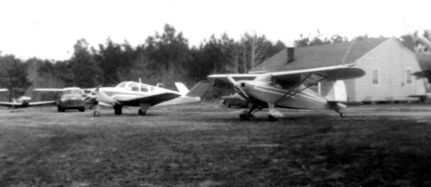
A circa 1956-59 photo (courtesy of Cheryl Nekos) of several planes in front of the house at Jacksonville Airport.
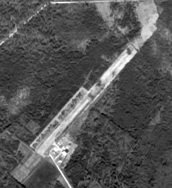
The earliest dated photo which has been located of the Jacksonville Airport was a 2/1/57 USGS aerial view.
It depicted Jacksonville as having a single northeast/southwest runway, with a ramp & small building on the south side.
Cheryl Nekos recalled, “My Dad (Bill Scott) owned/rented the [Jacksonville] Airport in the early 1960s.
He ran Onslow Aviation out of the office there. He also worked for the NC State Forest Service & flew for them from there.
The house to the left of the hangar is where we lived.
We had a lot of visitors to Camp Lejeune fly into our airport because it was the only private airstrip in the area.”
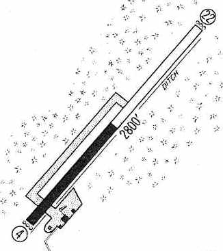
The 1960 Jeppesen Airway Manual (courtesy of Chris Kennedy) depicted Jacksonville as having a single 2,800' Runway 4/22, of which the southwestern half was paved.
A ramp on the south side of the field had 3 small buildings (hangars?). The airport was said to be unattended, and "closed to the public."
Richard Stockman recalled, “As for the pavement of 1,400' of the south end of the runway I do not remember that at all.
I spent many days with the tractor cutting the grass on the runway & parking area. There was no real taxi way down the side.
There was enough room for two planes to be on the runway at the same time but it never happened to my knowledge.”
The 1961 Norfolk Sectional Chart (courtesy of Chris Kennedy) depicted Jacksonville as a private field with a 2,800' unpaved runway.
The 1962 AOPA Airport Directory described Jacksonville Airport as consisting of a single 2,800' Runway 4/22 (1,400' paved & 1,400' turf).
The operator was listed as the NC Department of Conservation & Development, and the airport was listed as being "Closed to general public."
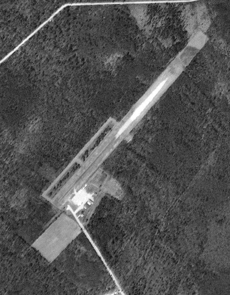
A 4/16/64 USGS aerial view depicted Jacksonville Airport as having a single northeast/southwest runway,
with a ramp & a few small buildings on the south side.
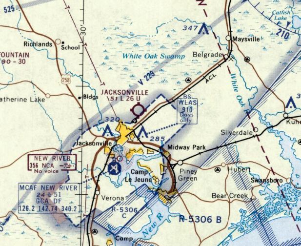
The last aeronautical chart depiction which has been located of Jacksonville Airport on the September 1966 Norfolk Sectional Chart.
It depicted Jacksonville as a public airport having a 2,600' unpaved runway.
Steve Hurst recalled, “I came back from Vietnam in 1966 with 6 hours in my logbook.
Stationed at Camp Lejeune, I looked for a place to work on a Private License, and I found the Jacksonville airport just outside of Camp.
The FBO was run by Allen Blake who was also the chief CFI, he along with Major Britt & John Lamb were the instructors.
These 3 instructors all had years of experience & instruction was excellent. I started flying an Aeronca 7AC for $5 / hour wet.
This & a Cessna 150 got me to a private license. There was plenty of business from Camp Lejeune & the nearby bases of Camp Geiger & Cherry Point.
With a private license I started flying friends home on weekends.
When the word got out I was quickly running a ferry service & soon had enough hours for a commercial license & the instrument rating that followed shortly.
Then I really was running a real ferry service. There were 20,000 Marines on the base & I could get them home in a hurry.
Allen was a Mooney dealer & purchased 2 Mooney Alon A-2s to use as trainers.
I went for an instructor rating & was just starting to instruct when my enlistment was over.
The training & experience I got at the little Jacksonville airport was top-notch & served me well in later years.”
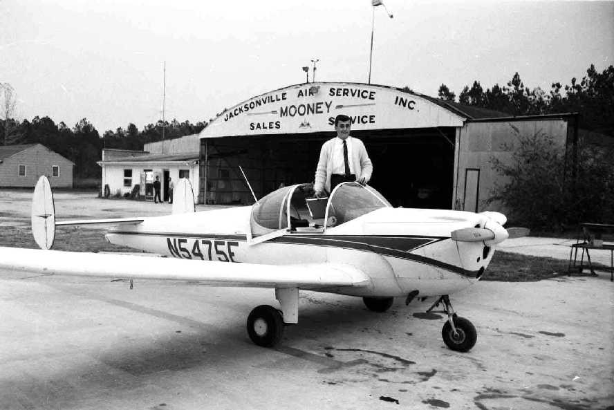
A March 1967 photo by Steve Hurst of his friend Ted Lunacek in one of the Alon A-2s on the Jacksonville Airport fueling ramp.
Steve observed, “The FBO office is to the left of the hangar. The inside of the office was wallpapered with student solo shirt cut-outs.”
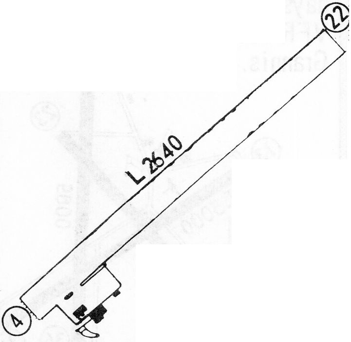
The 1968 Flight Guide (courtesy of Bob Levittan) depicted Jacksonville Airport as having a single unpaved 2,640' Runway 4/22,
with a small ramp at the southwest side of the field with several small buildings (hangars?).
Steve Hurst recalled, “Allen Blake retired about 1970.”
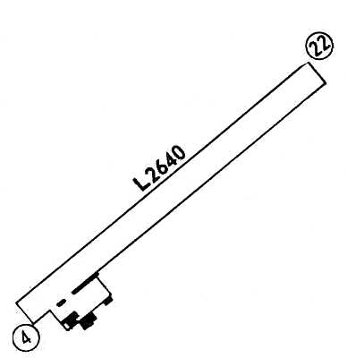
The 1971 Flight Guide (courtesy of Chris Kennedy) depicted Jacksonville Municipal Airport as having a single unpaved 2,640' Runway 4/22,
with a small ramp at the southwest side of the field with several small buildings (hangars?).
The 1971 Flight Guide also depicted Jacksonville's new airport, Albert Ellis Field, which had been built as a replacement several miles to the northwest of the town of Jacksonville.
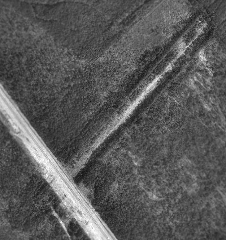
The original Jacksonville Airport was evidently closed within the next year, as it was no longer depicted on the March 1972 Charlotte Sectional Chart.
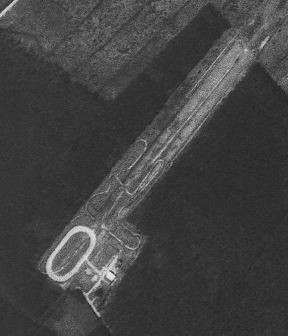
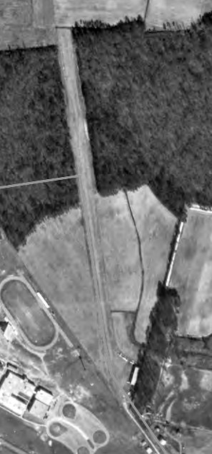
A 4/10/74 USGS aerial view showed an oval track had been built over the southern portion of the former Jacksonville Airport runway. The hangar remained standing,
The 1978 USGS topo map still depicted Jacksonville Airport, but it had apparently already been abandoned for several years at that point.
The original Jacksonville Airport continued to be depicted on the 1978 & 1991 USGS topo maps, quite a while after being abandoned.
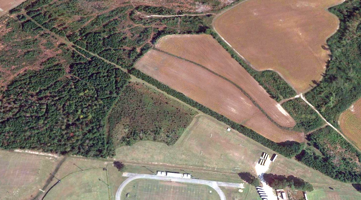
A 1993 USGS aerial photo showed the remains of the Jacksonville Airport runway were still clearly apparent,
but a new road, Western Boulevard, had been built across the southwestern end of the former runway at some point between 1974-93
(and right across the former ramp area, the outline of which is still barely visible).
No remnants of any former airfield buildings were still apparent.
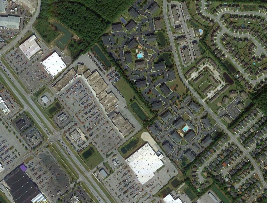
A 2015 aerial view of the site of Jacksonville Airport shows a starkly different scene compared to the 1993 aerial photo,
with several roads having been built over the airport site, erasing the traces of the former runway.
Steve Hurst observed, “Sadly a great little airport is no longer there, but the pilots trained there are still flying.”
The site of Jacksonville Airport is located east of the intersection of Western Boulevard & Gateway South, northeast of the town of Jacksonville.
____________________________________________________
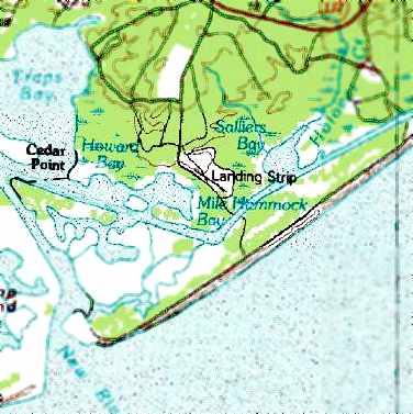
Blue Bird Marine Corps Expeditionary Airfield, Duck Creek, NC
34.553, -77.318 (Southeast of Jacksonville, NC)
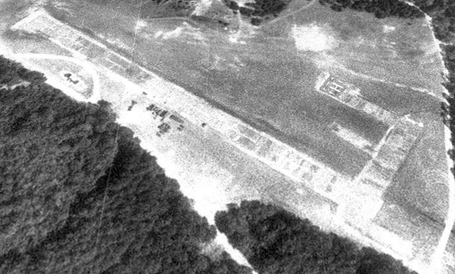
A 5/2/82 USGS aerial view of the Blue Bird Airfield.
This small airfield on the property of Camp Lejune is one of 31 Expeditionary Airfields operated by the Marine Corps.
Blue Bird EAF may have been built at some point between 1970-82, as it was not yet depicted on the 1970 USGS topo map.
The earliest depiction which has been located of Blue Bird Airfield was on a 5/2/82 USGS aerial view.
It depicted Blue Bird as having a single paved Runway 13/31.
The Blue Bird Airfield was labeled simply as “Landing Strip” on the 1991 USGS topo map.
The Blue Bird airfield was not depicted at all on aeronautical charts, and was not listed in the Airport Facility Directory as an airfield or heliport.
As seen in a 1993 USGS aerial view looking north, the Blue Bird Airfield consisted of a single northwest/southeast runway, along with a marked helipad on the east side.
In 1998 the Blue Bird EAF was rebuilt by members of the "Untouchables", Marine Wing Support Squadron 272,
as described in a article in the 9/16/98 issue of the Marines Digest.
According to Gunnery Sgt. John C. Jefferson, MWSS-272 EAF officer-in-charge,
given the nature of the operation & the work that had to be done,
this was one of the quickest & most successful airfield construction operations he has witnessed.
"We had to take up the existing EAF because the shoulders surrounding it have eroded in the past few years,
causing a hazard to landing aircraft," Jefferson said.
"Once all the mats were taken up, our engineers & heavy equipment (HE) sections built new dirt shoulders, and then a new airfield was constructed."
TLZ Blue Bird is a vertical/short takeoff & landing (VSTOL) site
used by helicopter & AV-8 Harrier pilots for combat mission training.
The airfield at Blue Bird consists of a single 1,700' runway, composed of hundreds of interlocking aluminum mats.
A taxiway leads a 96' square vertical takeoff & landing pad. The entire landing area has a total of 161,568 sq ft.
"The entire surface area was reworked about five years ago & is still in relatively good shape," Jefferson said.
"Only certain spots that laid under the old mats needed to be repaired for certification."
The Untouchables constructed their entire base camp, relocated necessary equipment from New River to the TLZ, assessed work requirements,
and started disassembling the runway on the 1st day at the site.
The squadron's base camp was spread throughout a wooded area adjacent to the TLZ
and consisted of a small number of the all-to-familiar general purpose tents,
covered with camouflage netting which made it virtually invisible to an untrained eye.
The estimated time taken to complete the operation was 4 weeks.
The Untouchables completed the task in a mere 2 weeks.
"The troops deserve every bit of the credit for another successful operation," said Lt. Col. Danny Brush, MWSS-272 commanding officer.
"They came out here & broke their backs to meet the needs of the Corps."
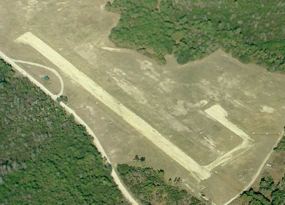
A circa 2008-2010 aerial photo looking north at the Blue Bird airfield showed a single runway, a single helipad, and one small building on the southwest side.
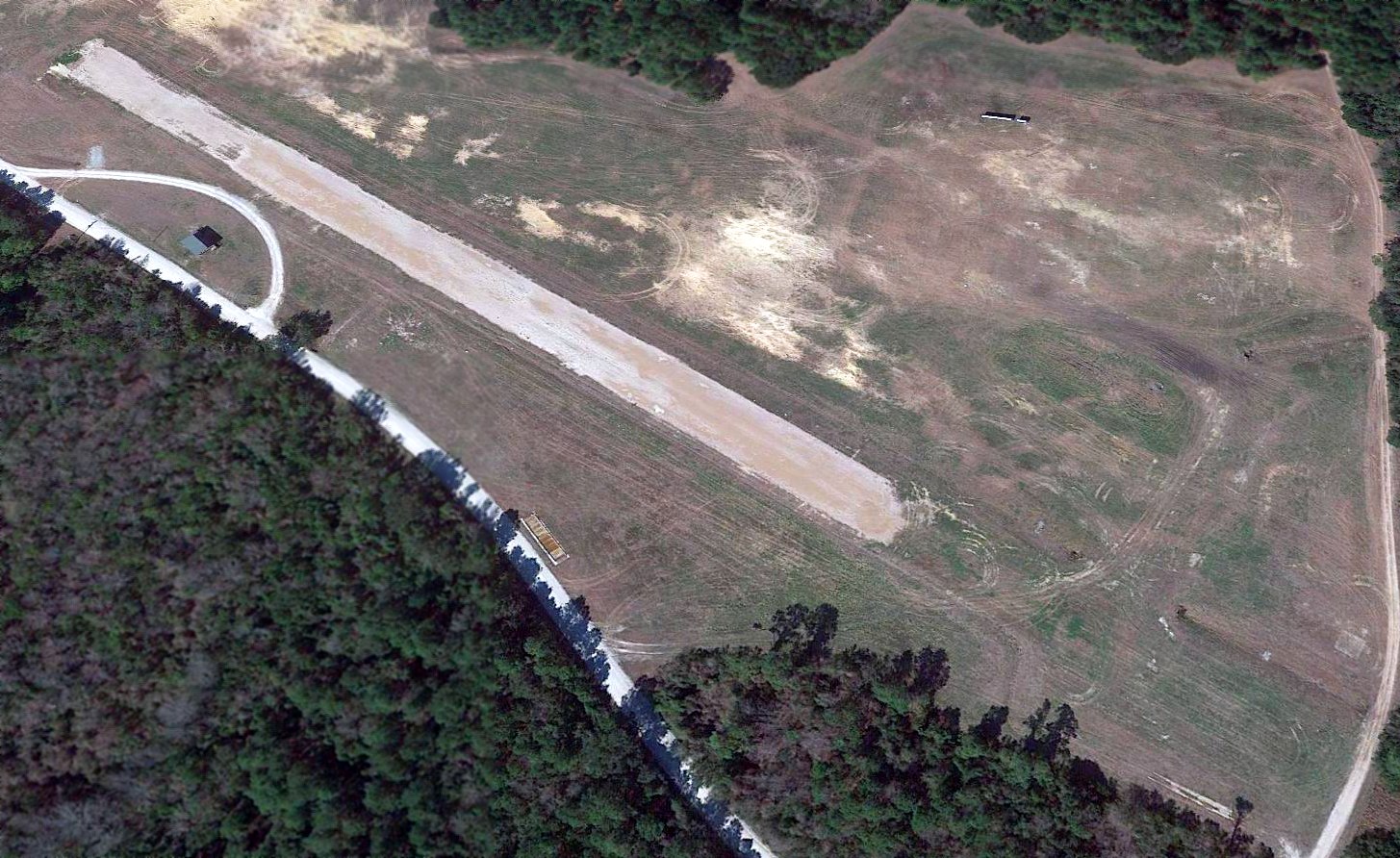
A 2017 aerial view looking north shows that the majority of the Blue Bird Airfield runway pavement remains intact,
but strangely the southeastern portion of the runway pavement along with the helipad on the east side were completely removed at some point in 2011.
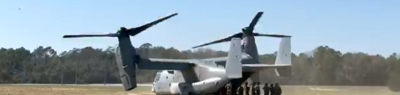
A 2023 photo of a Marine Corps Bell Boeing MV-22B Osprey tilt rotor at the Blue Bird Airfield.
Blue Bird EAF is located on the northeast shore of Mile Hammock Bay, 1.5 miles south of Route 172, less than a mile from the Atlantic Ocean.
____________________________________________________
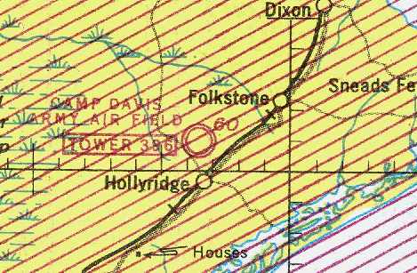
Camp Davis Army Airfield / Hollyridge Army Airfield /
Camp Davis Marine Corps Outer Landing Field (14NC), Holly Ridge, NC
34.52, -77.55 (Southwest of Jacksonville, NC)
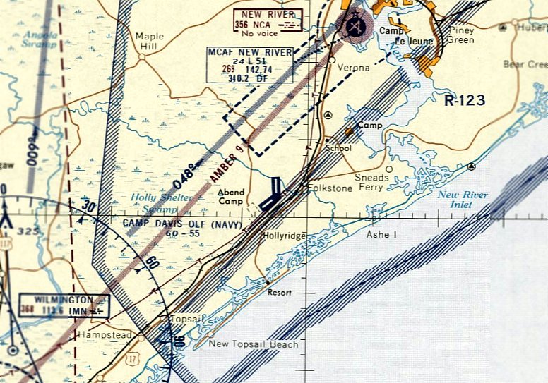
Camp Davis AAF, as depicted on the September 1943 Norfolk Sectional Chart (courtesy of Chris Kennedy).
Camp Davis was originally built in 1940 as an Army anti-aircraft artillery training facility.
It was an expansive facility, consisting of more than 3,000 buildings on 45,538 acres,
with access provided by newly-built railroad spurs leading into the camp.
Two 5,000' paved runways were built by the Army at Camp Davis at some point between 1942-43.
A list of airfields used by the U.S. Government listed the field as “Hollyridge AAF”, and indicated usage started on 1/1/43.
No airfield was yet depicted at Camp Davis on the March 1943 Norfolk Sectional Chart.
The earliest depiction of Camp Davis AAF which has been located was on the September 1943 Norfolk Sectional Chart (courtesy of Chris Kennedy).
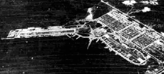
The earliest photo which has been located of Camp Davis was a 9/27/43 aerial view looking east
from the 1945 AAF Airfield Directory (courtesy of Scott Murdock).
It depicted the field as having 2 paved runways, with dozens of dispersal parking spots, and a large number of buildings along the road on the southeast side.
Camp Davis' Runway 5/23 was wider, and was intended for use by transports,
while Runway 18/36 was narrower, and intended for use by single-engine aircraft.
Most of the aircraft which operated from the Camp Davis runways were single-engine aircraft
which were used to tow targets for the anti-aircraft artillery units.
A grid of streets & a large number of buildings was depicted at Camp Davis on the 1943 USGS topo map, but nothing of the airfield was depicted.
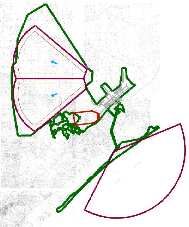
A WW2 era view looking east at Camp Davis, with the 2 runways at the left & center of the photo.
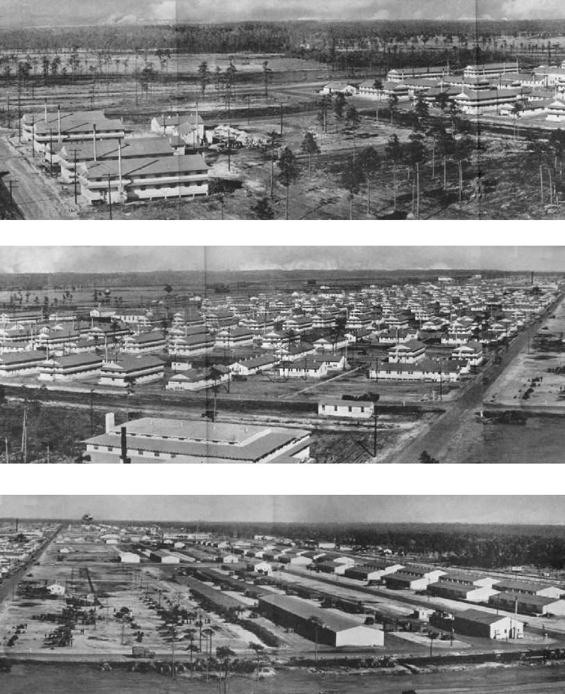
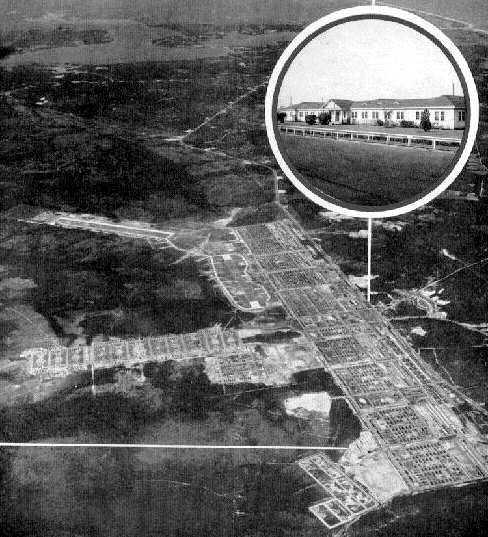
A pre-1944 series of panoramic images of Camp Davis' cantonment area (courtesy of Joe Benson).
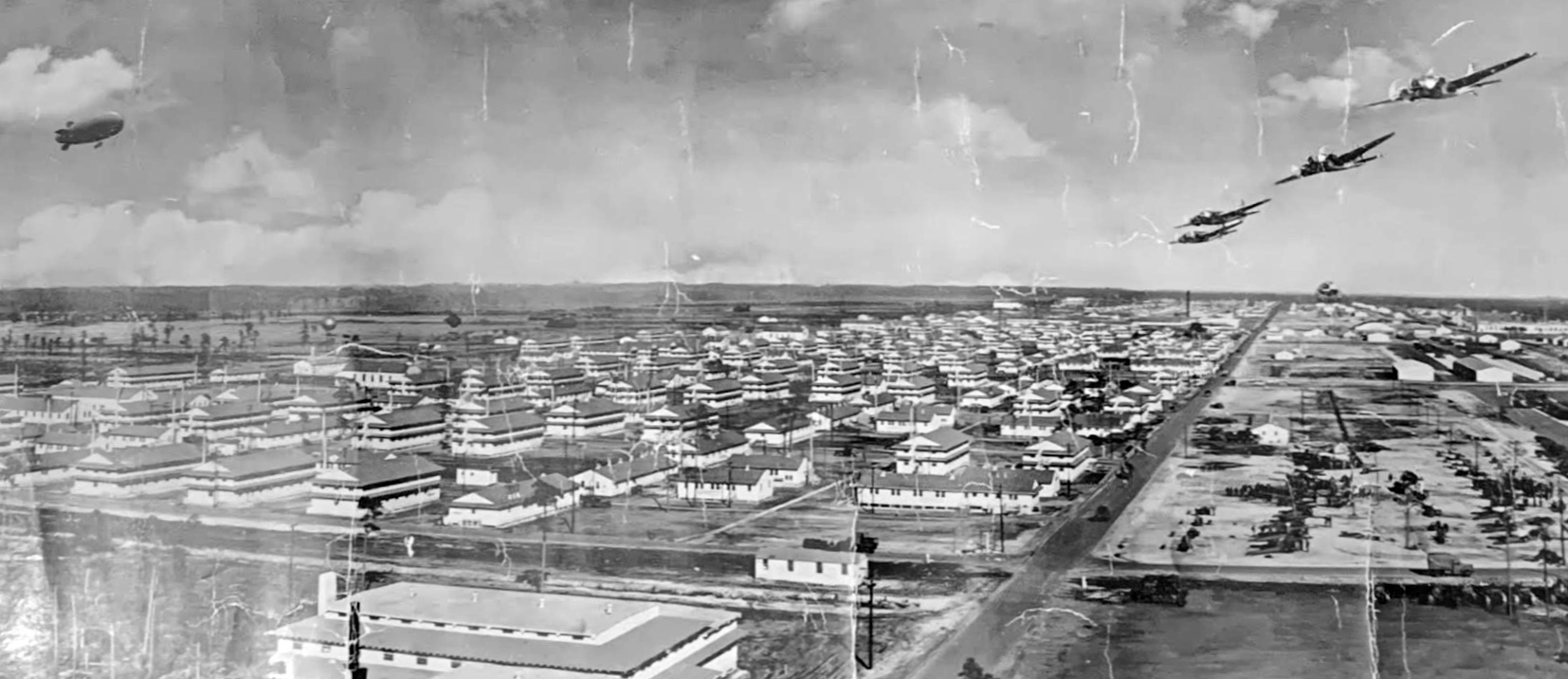
Another version of the pre-1944 panoramic image of Camp Davis (courtesy of Jim Mathenia).
In 1944 the anti-aircraft training facility was transferred to another base, and Camp Davis was closed by the Army.
"Camp Davis AAF" & its associated firing area, as depicted on the April 1945 Norfolk Sectional Chart (courtesy of Chris Kennedy).
The 1945 AAF Airfield Directory (courtesy of Scott Murdock) described Camp Davis AAF
as a 3,200 acre irregularly-shaped property containing a 5,100' concrete north/south runway & a 4,500' asphalt northeast/southwest runway.
The field was said to have 2 wooden hangars, the largest measuring 121' x 96'.
Camp Davis was described as being owned by the U.S. Government, and operated by the Army Air Forces.
A list of airfields used by the U.S. Government indicated that usage of “Hollyridge AAF” ended on 8/31/45.
In 1945, a portion of the Camp Davis area that was formerly used by the Army as the Coastal Artillery Anti-Aircraft Firing Range
(and is the location of the present-day town of Surf City) was transferred to the Navy.
The site was used by the Navy for the development & testing of early surface-to-air missiles, under the name "Operation Bumblebee".
The Camp Davis airfield was no longer depicted at all on the April 1946 Norfolk Sectional Chart (courtesy of Jim Stanton).
In 1948, the Navy closed down missile operations at Camp Davis.
Camp Davis was declared surplus & was dismantled in the late 1940s for salvage & sale.
At that time the Navy apparently gave up the leases on the land & it was returned to the original landowners.
Ironically, the 1948 USGS topo map depicted the extensive street grid along the southern part of Camp Davis, but no airfield facilities were depicted at all.
In the words of Joe Benson, "I came to Jacksonville every year when school was out from about 1949-62.
Every year Camp Davis changed. As I think back, it was like a slow flickering film.
One year, everything was there. The next some buildings gone. The next, even more.
As the buildings went, the thing that started becoming the principal landmark was all the chimneys from the buildings.
For some reason, they never touched the brick chimneys even to this day, so to speak.
For years, they looked like brick trees, there were so many.
If you go in there now, you can still see many on the ground that were just eventually knocked over.
I guess others were finally stripped by people over time for the brick.
But I'll never forget that forest of chimneys for years. There's probably enough chimney bricks left there to build a house if you wanted!"
In 1954, the U.S. Marine Corps took out a new lease for approximately 955 acres
on the former Camp Davis airfields & surrounding land from International Paper Company.
“Camp Davis OLF (Navy)” was depicted on the January 1958 Norfolk Sectional Chart as having two paved runways runways, with the longest being 5,500'.
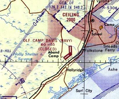
Camp Davis was still listed as a Navy facility on the 1965 Norfolk Sectional Chart (courtesy of John Voss), but was still labeled "Closed".
It was described as having two 5,500' concrete runways.
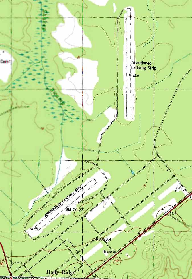
The 1981 USGS topo map depicted the 2 runways at Camp Davis as “Abandoned Landing Strip”.
Howie Howe recalled a deployment to the Camp Davis airfield.
"In the early 1980's, my Marine Crops Reserve unit was activated for a weekend, and put on Air Force transports.
We were flown from NAS South Weymouth, MA,
down to an abandoned airfield [Camp Davis MCOLF] adjacent to Camp Lejeune.
When we landed the runway was in very bad need of maintenance, there were no standing structures,
and the air traffic control operations were done by radiomen using jeep mounted UHF radios.
I do remember seeing some overgrown foundations, and that the road from the field out to Highway 17 was dirt."
Ken Roberts recalled, “Camp Davis AAF airfield... in the early 1980s we used to drag race our cars on that runway!
Everyone with a hot-rod in that corner of the state knew about 'Holly Ridge' as we called it.
The entire area was uncontrolled, access was never a problem.
We used to just drive out there, always a crowd on Saturdays & Sundays."
A 1986 close-up by Paul Cotrufo, looking east at the deck outline of an LPH helicopter carrier,
painted on the north/south runway at Camp Davis.
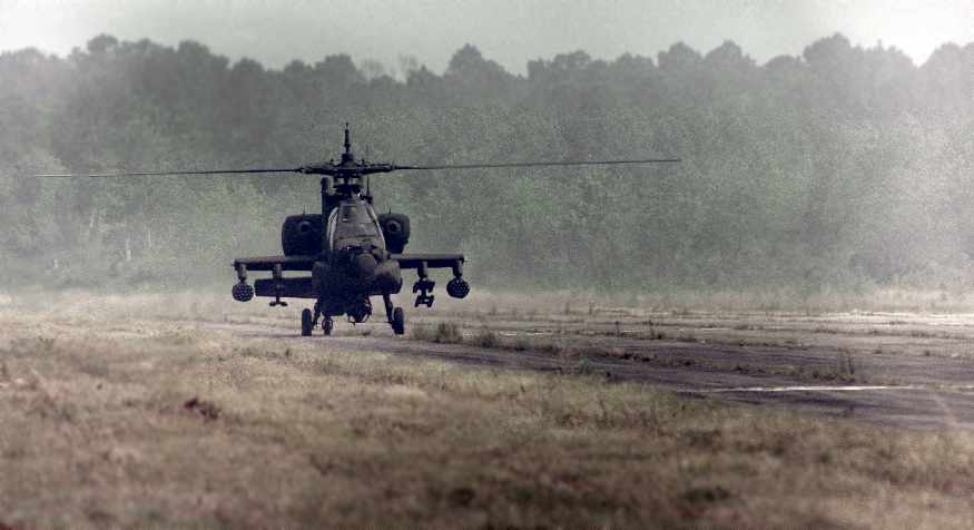
A May 1989 photo by T. Birrenkott of an Army AH-64A Apache helicopter returning to Camp Davis from an assault mission
during the joint services Exercise Solid Shield 89.
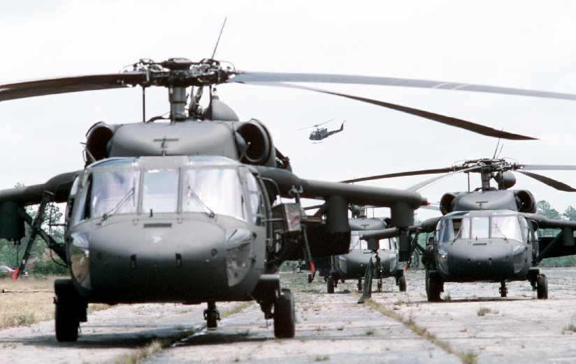
A May 1989 photo by Scott Stewart of Army UH-60 Black Hawk helicopters from the 101st Airborne Division
on the airfield at Camp Davis during the joint services exercise Solid Shield 89.
Also note the Marine UH-1N Iroquois helicopter passing overhead in the background.
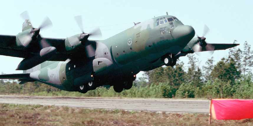
A May 1989 photo by Scott Stewart of a C-130 Hercules from the 317th Tactical Air Wing lifting off from the runway at the Camp Davis airfield
carrying soldiers from the 101st Airborne Division at the conclusion of the joint services exercise Solid Shield 89.
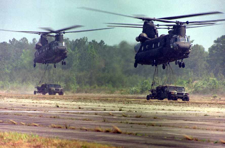
A May 1989 DOD photo by Sgt. Birrenkott of 2 CH-47 helicopters hovering at Camp Davis
as they prepare to make an external lift of 2 sets of M-998 HMMWVs & 105mm towed howitzers during Operation Solid Shield '89.
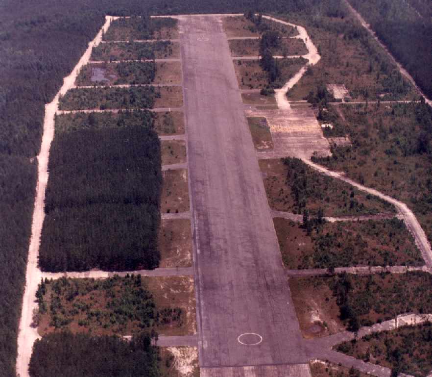
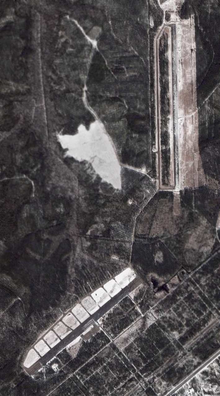
A 1990 aerial view by Paul Cotrufo looking northeast along Camp Davis' northeast/southwest runway.
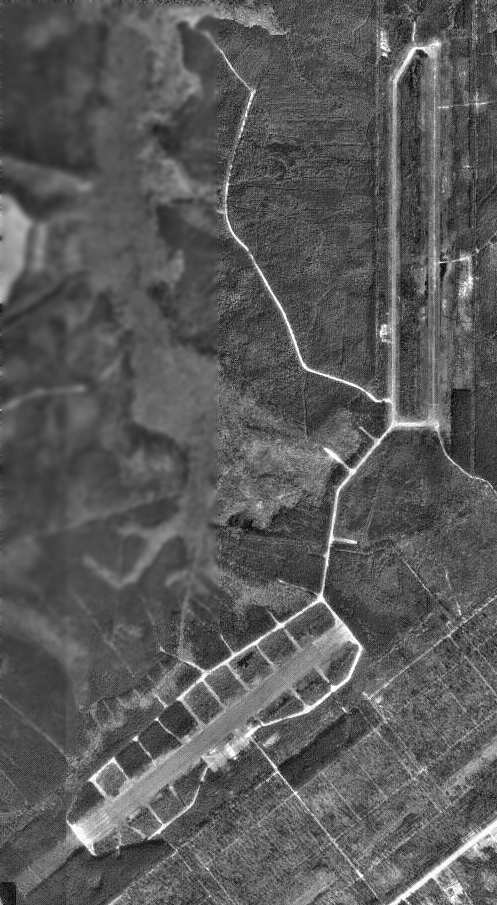
A 1996 USGS aerial view of the 2 Camp Davis runways.
Camp Davis has been used in recent years by the Marines as a satellite airfield
for helicopter units based at nearby New River MCAS.
The gate is located along the west side of NC Route 17, just North of Holly Ridge.
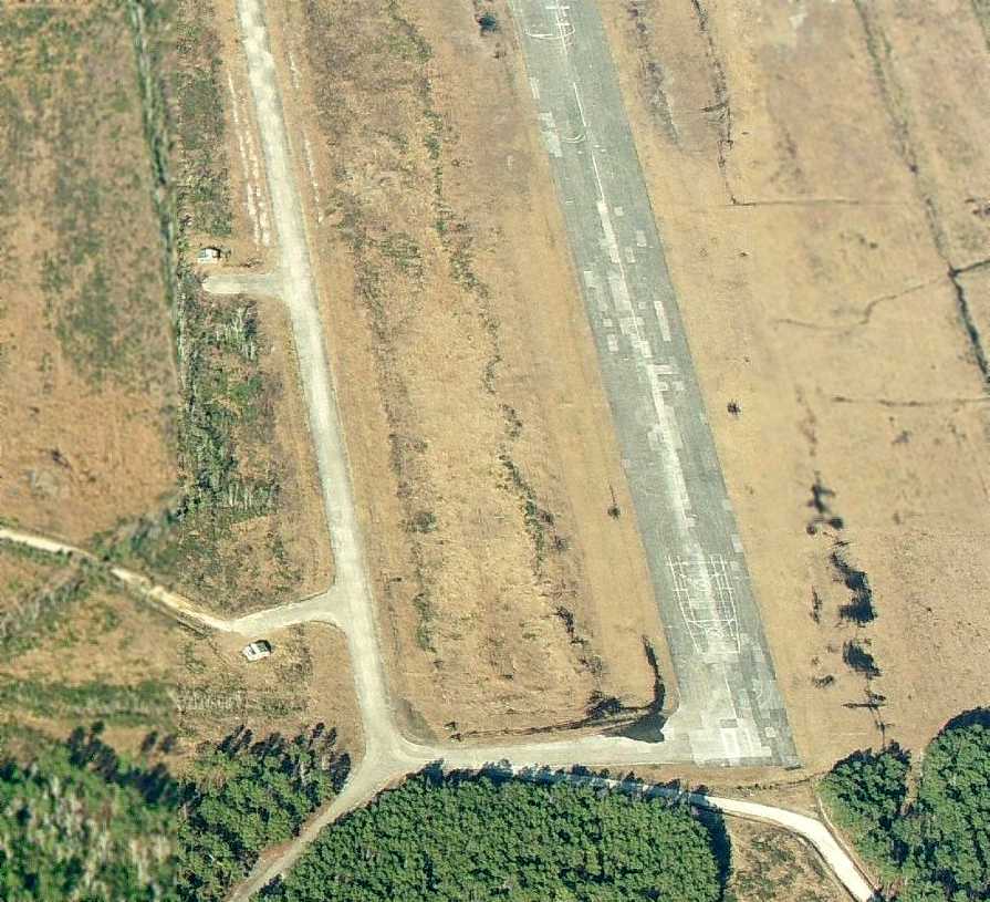
The airfield at Camp Davis currently consists of 2 paved 5,000' runways (5/23 & 18/36),
along with an extensive network of taxiways & parking ramps.
Runway 18/36 was being resurfaced with concrete in 1997,
possibly for use by the V-22s which would be based at nearby MCAS New River in increasing numbers over the next few years.
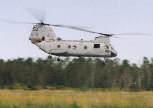
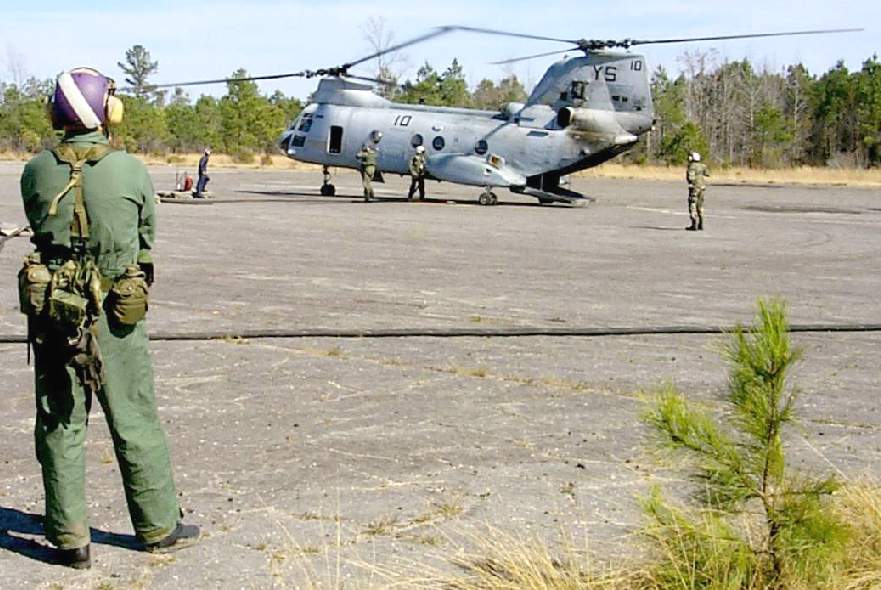
A 1997 photo by Paul Freeman of a CH-46E performing a practice low approach to Runway 5/23.
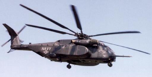
A 1997 photo by Paul Freeman of an MH-53E performing a practice low approach to Runway 5/23.
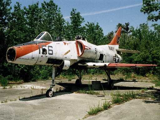
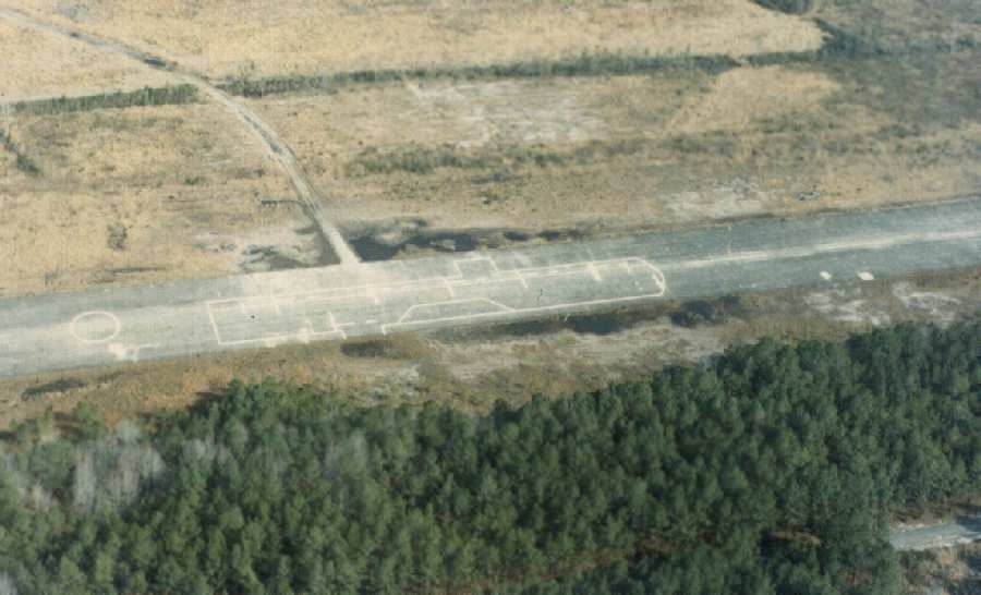
A 1997 photo by Paul Freeman of one of 2 derelict USN TA-4Js
which are still parked at end of parking ramps in between the 2 runways.
The TA-4J was previously used for external load operations by New River CH-53s.
According to Michael Montgomery (who worked on TA-4s at Kingsville),
this Skyhawk was previously assigned to TW-2 at NAS Kingsville, TX.
According to Glenn Diefenderfer, “The TA-4J at Camp Davis... I actually flew that plane.
I was an instructor in Kingsville, TX (VT-22), during the 1970s & flew about 1,800 hours in the TA-4Js.”
In 1998, Jamie Clabaugh was a Marine at Camp Lejune,
and he recalled coming across the TA-4J while on an exercise.
"I was in a reconnaissance unit & that day I had hiked from the main highway all the way to the far runway
which took a good 2 days through the swamp.
We were working on anti-terrorist training at the time
and our mission on that day was to watch a suspected terrorist training camp
that was located about 500 meters north of where that plane was located.
We had set up base camp right next door to that aircraft & got to know that plane quite well."
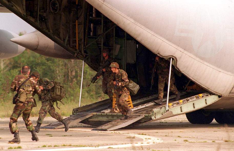
Members of Company 4 run off a USAF C-130 Hercules at Camp Davis
DoD photo by Army Staff Sgt. M.A. Jones.
Peter Hantelman reported about the TA-4J pictured above at Camp Davis:
“That A-4 appeared in the 'junkyard' at Defense Reutilization Management Office at MCAS Cherry Point in around summer 2001.
I drove past in several times a week, and recognize that particular hulk, plus its identification marks.
It sat there for about a year, before it disappeared. There was a write-up about it in the base newspaper.
It was demilitarized, then shipped on a barge into the training areas east on base.
It sits at a mock-up runway, along with other targets for the Harrier pilots to practice bomb.”
A 2002 photo of a CH-46E at Camp Davis,
as Marine Wing Support Squadron-272 used the field to conduct pre-deployment training.
The purpose of this was to provide advanced training for the air base ground defense platoon
and a warm-up exercise for their upcoming deployment to Spain
Howie Howe reported in 2003, "It appears that the Marines have recently purchased a majority of Camp Davis
and may now be referring to it as the Greater Sandy Run Training Area."

A March 30, 2006 aerial view of 2 A-4s parked on ramps in between the 2 Camp Davis runways.
An aerial photo from only 3 months later appeared to show that both aircraft had been removed.
A winter 2006 aerial view showed a dusting of snow around the Camp Davis runways.
A circa 2008-2010 aerial view looking north along Camp Davis' Runway 36
showed 2 small buildings along the southwest side of the runway.
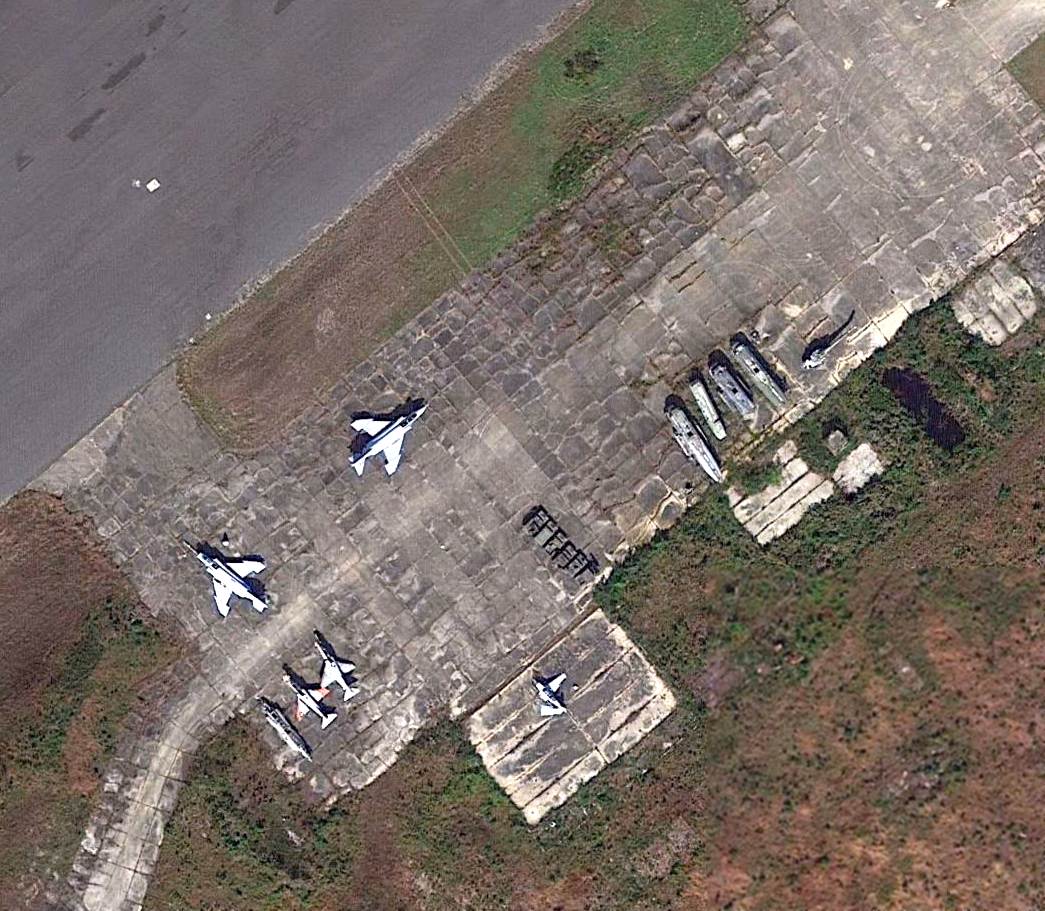
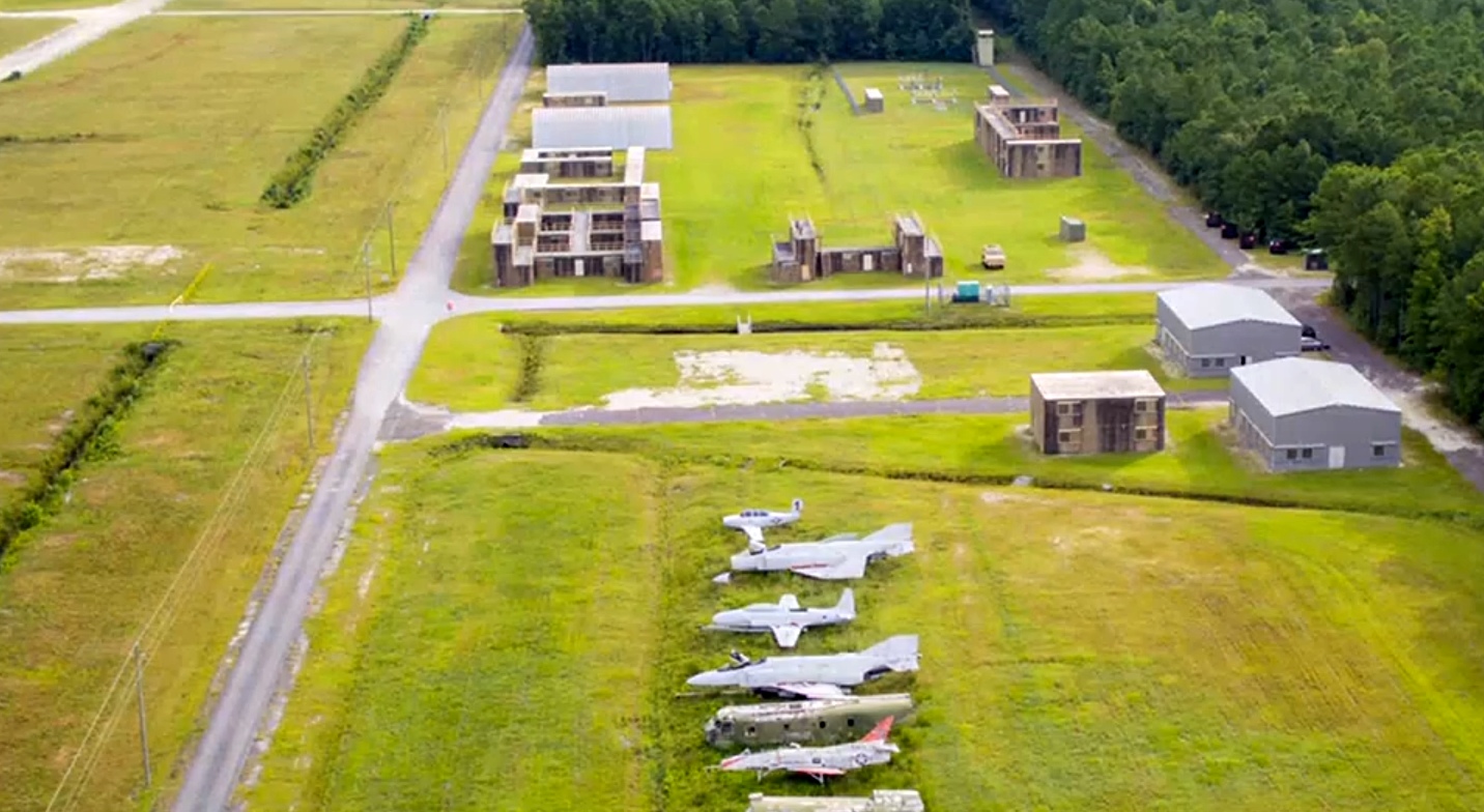
A 2015 aerial view of the ramp on the south side of Camp Davis' Runway 5/23,
showing a total of 11 aircraft, including 2 F-4 Phantoms, 2 A-4 Skyhawks, a T-34 Mentor, 3 CH-53s, a UH-1, and a CH-46.
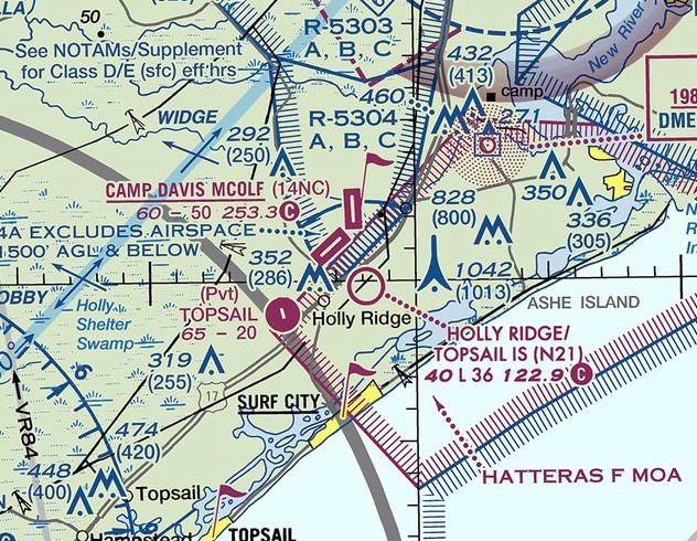
Camp Davis MCOLF was depicted on the 2017 Sectional Chart as having 2 paved runways.
A 2019 aerial view looking northwest at MCOLF Camp Davis.
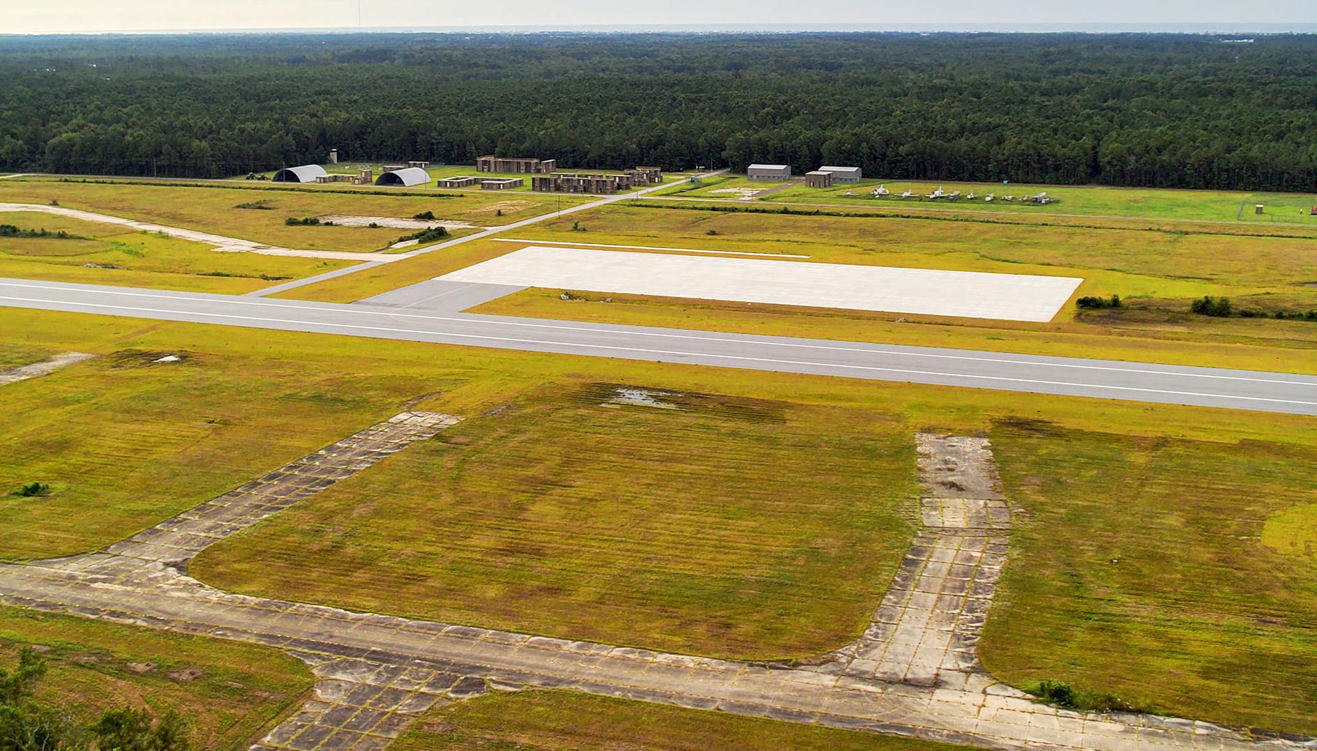
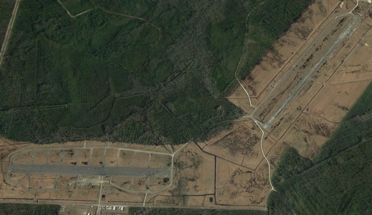
A 2024 USMC aerial view looking southeast at the MCOLF Camp Davis southwestern runway, showing that it has been refurbished & reopened to support aviation training.
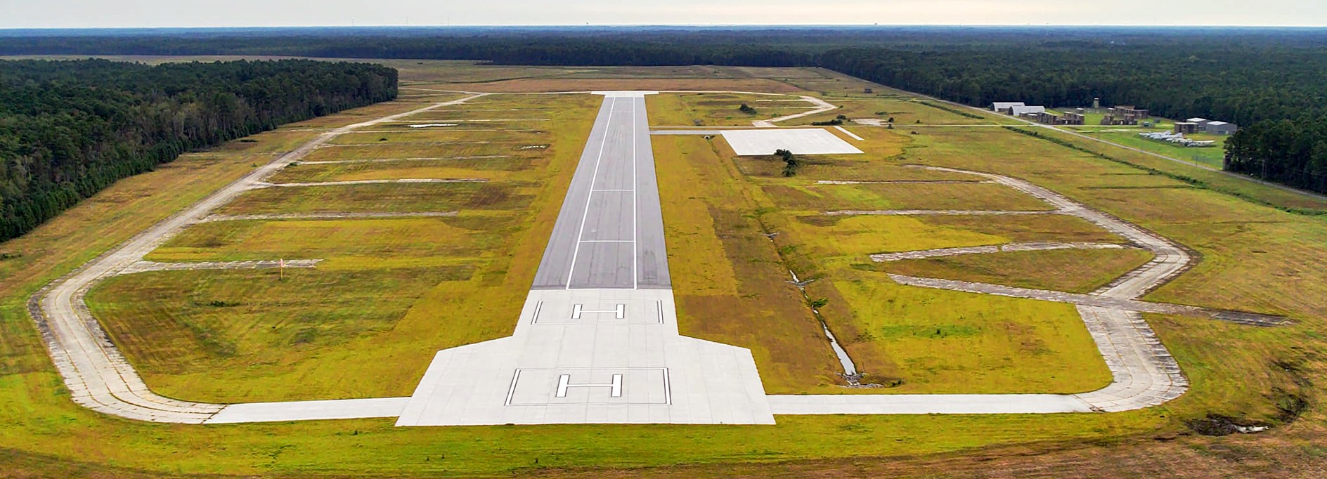
A 2024 USMC aerial view looking northeast along the southwestern MCOLF Camp Davis runway, showing that it has been refurbished & reopened to support aviation training.
See also: http://www.hnd.usace.army.mil/OEW/factshts/factshts/cmpdavis.pdf
____________________________________________________
Or if you prefer to contact me directly concerning a contribution (for a mailing address to send a check),
please contact me at: paulandterryfreeman@gmail.com
If you enjoy this web site, please support it with a financial contribution.
____________________________________________________
This site covers airfields in all 50 states.