Abandoned & Little-Known Airfields:
Western Montana
© 2003, © 2026 by Paul Freeman. Revised 2/21/26.
This site covers airfields in all 50 states: Click here for the site's main menu.
____________________________________________________
Please consider a financial contribution to support the continued growth & operation of this site.
681st Aircraft Control & Warning Squadron Airfield (added 11/2/20) - (Original) Eureka Airport (revised 8/24/23) - Garden City Airport / Hale Field (revised 6/7/17)
Great Falls AAF / Malmstrom AFB (revised 2/21/26) - Higgins Airfield (added 1/24/18) - Seeley Lake USFS Airfield (revised 10/13/24)
West Yellowstone Airport (revised 8/24/23) - Whitehall Intermediate Field (revised 12/27/22)
____________________________________________________
681st Aircraft Control & Warning Squadron Airfield, Croff Lake, MT
48.934, -112.795 (Northwest of Great Falls, MT)
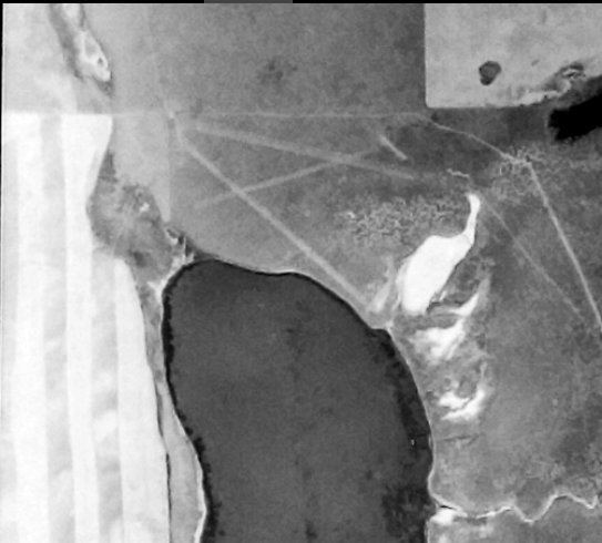
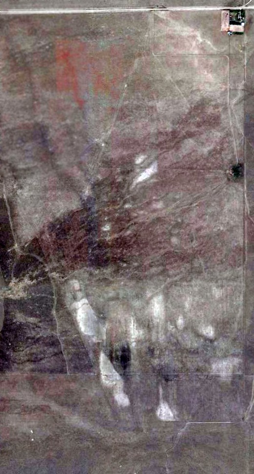
The 681st Aircraft Control & Warning Squadron Airfield, as depicted on a 1958 USGS aerial photo (courtesy of Lee Corbin).
Photo of the airfield while in use has not been located.
This small military aviation airfield was located in a very remote area, only 2 miles from the Canadian border.
According to radomes.org, the USAF's 681st Aircraft Control & Warning Squadron started operating AN/FPS-3 & AN/FPS-4 radars at this location in April 1952.
The installation was at first known as Del Bonita Radar Station, and later as Cut Bank Air Force Station.
At some point before 1958, the radar station gained its own small airfield, presumably to provide logistical support to the very remote radar base.
Many USAF radar facilities in AK had their own similar small airfield for logistical support, but this was rare among radar facilities in the 48 contiguous states (an exception being Cape Charles VA).
Inexplicably, the 681st Aircraft Control & Warning Squadron Airfield was not depicted on Glacier Park Sectional Charts from 1954/59/60/64.
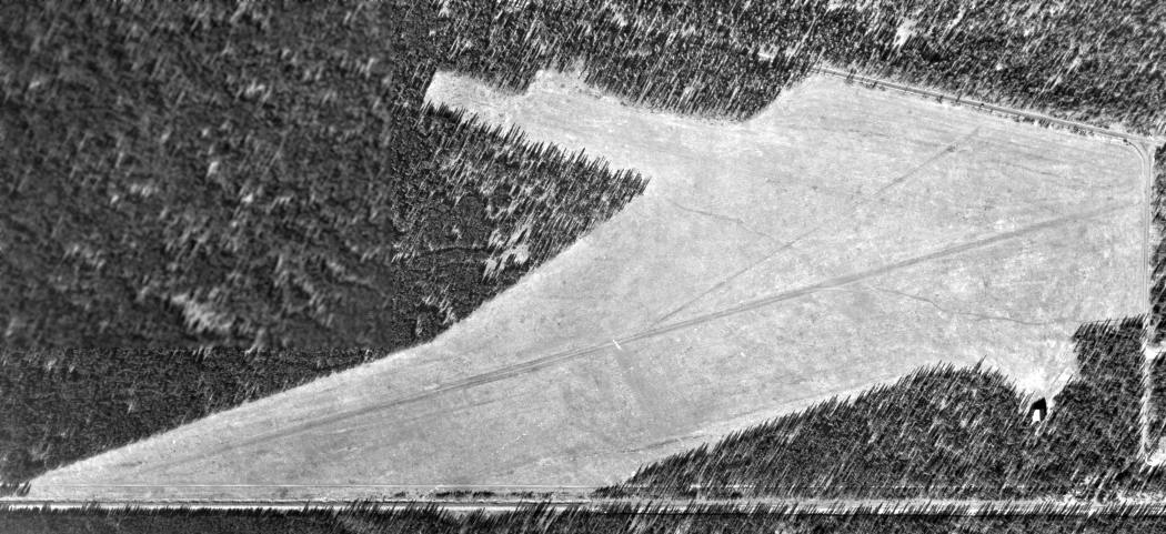
The earliest depiction which has been located of the 681st Aircraft Control & Warning Squadron Airfield was a 1958 USGS aerial photo (courtesy of Lee Corbin).
It depicted 3 unpaved runways, adjacent to the north side of Croff Lake.
With wide-open land for miles around, it would seem odd to situate the airfield adjacent to the only water obstacle in the area.
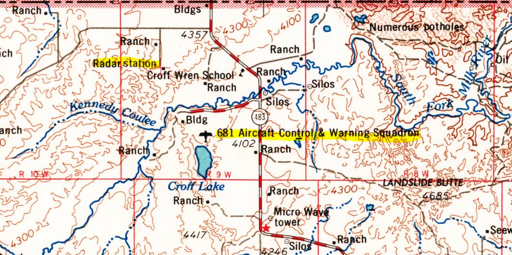
The 681st Aircraft Control & Warning Squadron Airfield, as depicted on the 1964 USGS topo map (courtesy of Lee Corbin).
Note that the “Radar Station” which the airfield supported was depicted erroneously a mile to the northwest, whereas the actual radar station location was labeled simply “Bldg”.
This may have been an example of an intentional error for security purposes.
According to radomes.org, Cut Bank AFS was removed from service on 3/1/65, and the 681st Aircraft Control & Warning Squadron was deactivated on 6/25/65,
at which point its airfield was presumably abandoned.
The 681st Aircraft Control & Warning Squadron Airfield was no longer depicted on the 1972 USGS topo map.
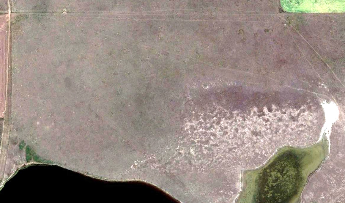
A 2014 aerial view of the site of the 681st Aircraft Control & Warning Squadron Airfield showed faint traces remained of the 3 unpaved runways.
Thanks to Lee Corbin for pointing out this airfield.
____________________________________________________
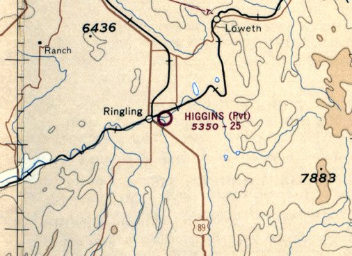
Higgins Airfield, Ringling, MT
46.268, -110.789 (Northeast of Butte, MT)
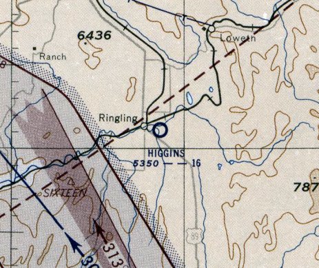
Higgins Airfield, as depicted on the October 1955 Butte Sectional Chart.
Photo of the airfield while in use has not been located.
This small general aviation airfield was evidently established at some point between 1950-55,
as it was not yet depicted on the April 1950 Butte Sectional Chart.
The earliest depiction which has been located of Higgins Airfield was on the October 1955 Butte Sectional Chart.
It depicted Higgins Airfield as having a mere 1,600' unpaved runway.
The last aeronautical chart depiction which has been located of Higgins Airfield was on the February 1971 Butte Sectional Chart.
It depicted Higgins as a private airfield having a 2,500' unpaved runway.
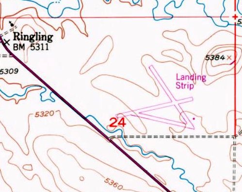
The 1980 USGS topo map (courtesy of Lee Corbin) depicted Higgins Airfield as 3 runways, labeled generically as “Landing Strip”.
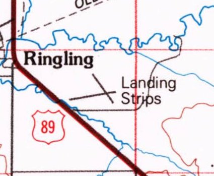
The 1993 USGS topo map (courtesy of Lee Corbin) depicted Higgins Airfield as 2 runways, labeled generically as “Landing Strips”.
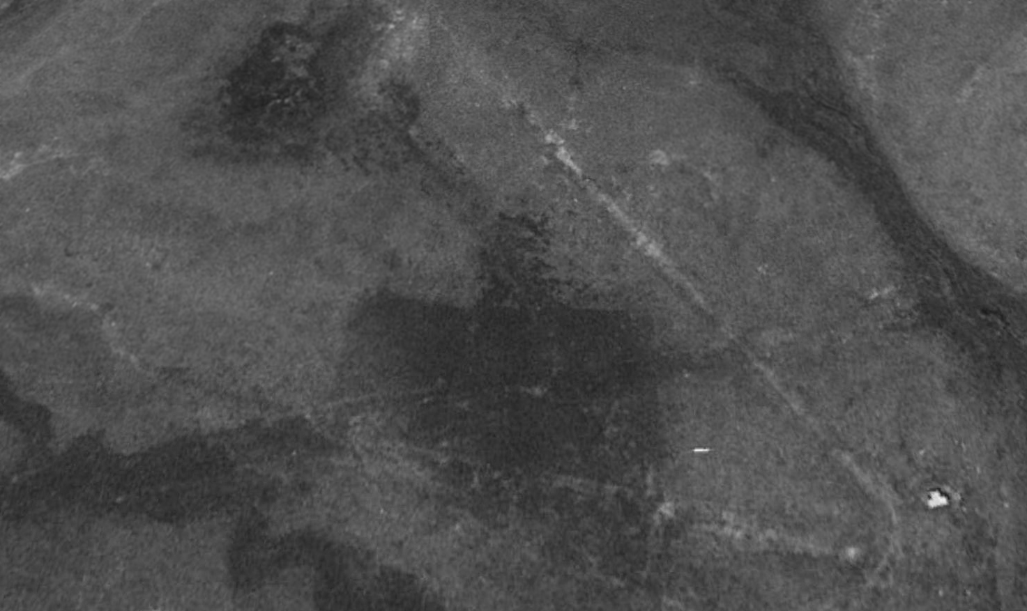
The earliest photo which has been located of Higgins Airfield was a 1997 USGS aerial view looking north.
It showed the very deteriorated remains of 3 unpaved runways & a T-hangar at the southeast corner.
A 2014 aerial view looking north (courtesy of Lee Corbin) showed the remains of the 3 runways of Higgins Airfield to still be barely recognizable.
A 2014 aerial view (courtesy of Lee Corbin) showed the remains of the T-hangar on the southeast corner of the Higgins Airfield site.
Its roof had evidently come off at some point between 1997-2014.
Higgins Airfield was no longer depicted on the 2018 Great Falls Sectional Chart.
The site of Higgins Airfield is located northeast of the intersection of Route 89 & New Dorsey Road.
Thanks to Lee Corbin for pointing out this airfield.
____________________________________________________
(Original) Eureka Airport, Eureka, MT
48.916, -115.085 (Northwest of Great Falls, MT)
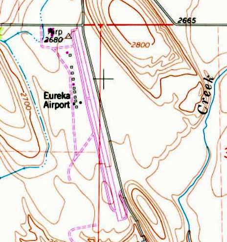
Eureka Airport, as depicted on the October 1946 Kootenai Sectional Chart.
The original airfield for the town of Eureka was located on the northwest side of the town.
Eureka Airport was evidently established at some point in 1946,
as it was not yet depicted on the April 1946 Kootenai Sectional Chart.
The earliest depiction which has been located of Eureka Airport was on the October 1946 Kootenai Sectional Chart.
It depicted Eureka as an auxiliary airfield.
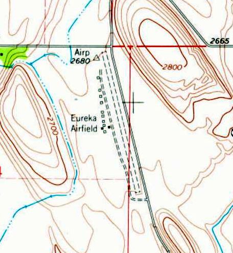
The 1963 USGS topo map depicted “Eureka Airfield” as having a northwest/southeast unpaved runway,
with a parallel unpaved taxiway & a row of 11 small buildings on the west side.
Eureka Airport evidently gained a paved & lengthened runway at some point between 1963-83,
as that is how it was depicted on the 1983 USGS topo map.
At some point between 1983-95 a larger replacement Eureka Airport was built several miles to the northeast,
as depicted on a 1995 USGS aerial photo, and the original Eureka Airport was presumably closed.
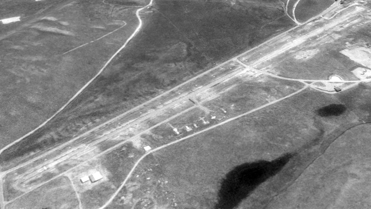
The earliest photo which has been located of the original Eureka Airport was a 1995 USGS aerial view looking southeast.
The original airport had been closed, as indicated by the closed-runway “X” markings, and several of the small hangars had been removed.
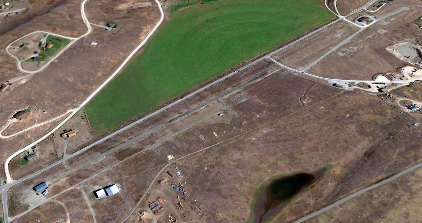
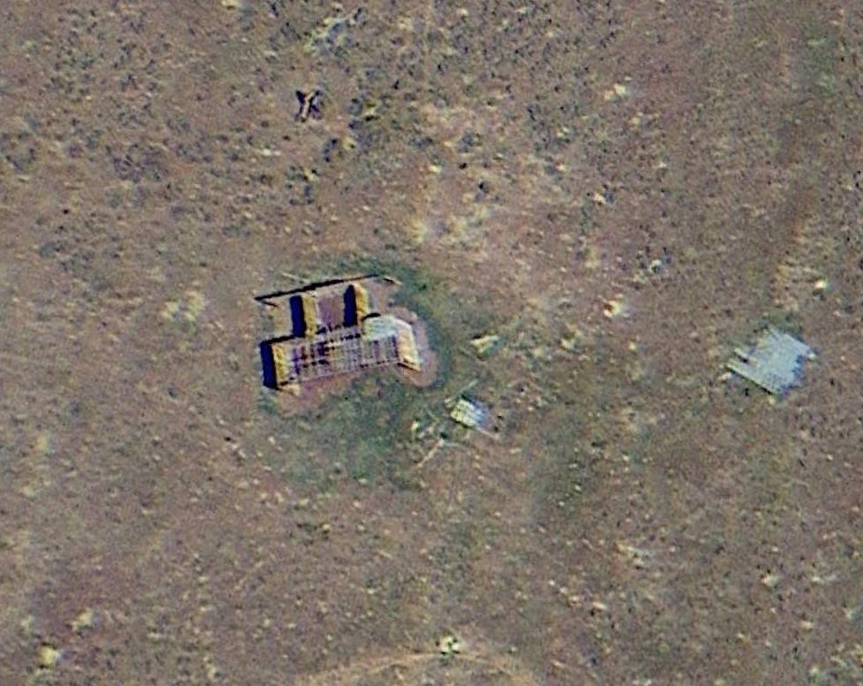
A 2014 aerial view looking southeast at the site the original Eureka Airport showed that the majority of the runway pavement remained intact,
though a building had been constructed over the north end of the runway, and another building had been constructed over the southern end.
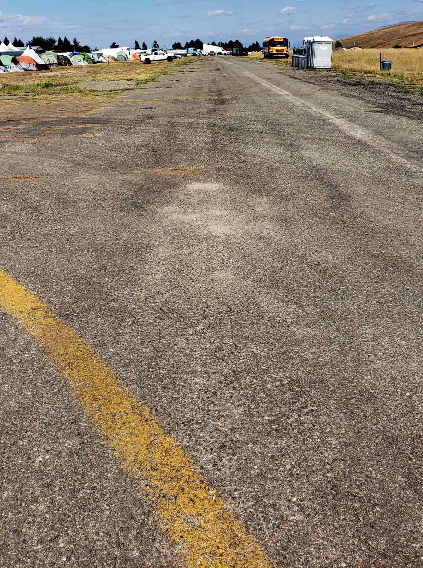
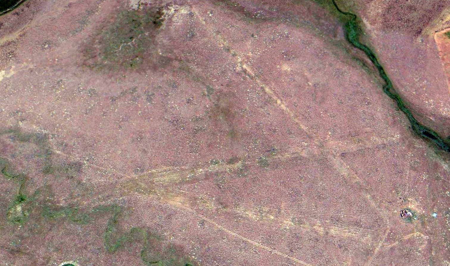
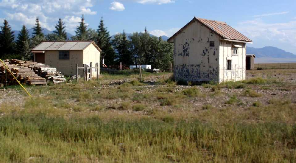
An 8/24/23 photo looking north along the original Eureka Airport runway.
The photographer observed, “It is being used as the base camp for the East Fork forest fire. This is where the firefighters get their briefing & meals, and where the operational people run the day-to-day operations for the fire.
There are a couple original buildings [barely visible at top-left, the northwest portion of the site], where the morning briefings for the firefighters are done.”
The site of the original Eureka Airport is located southwest of the intersection of Iowa Flats Road & Airport Road, appropriately enough.
Thanks to Lee Corbin for pointing out this airfield.
____________________________________________________
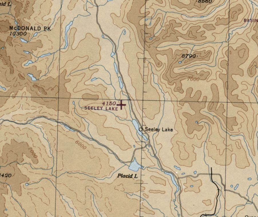
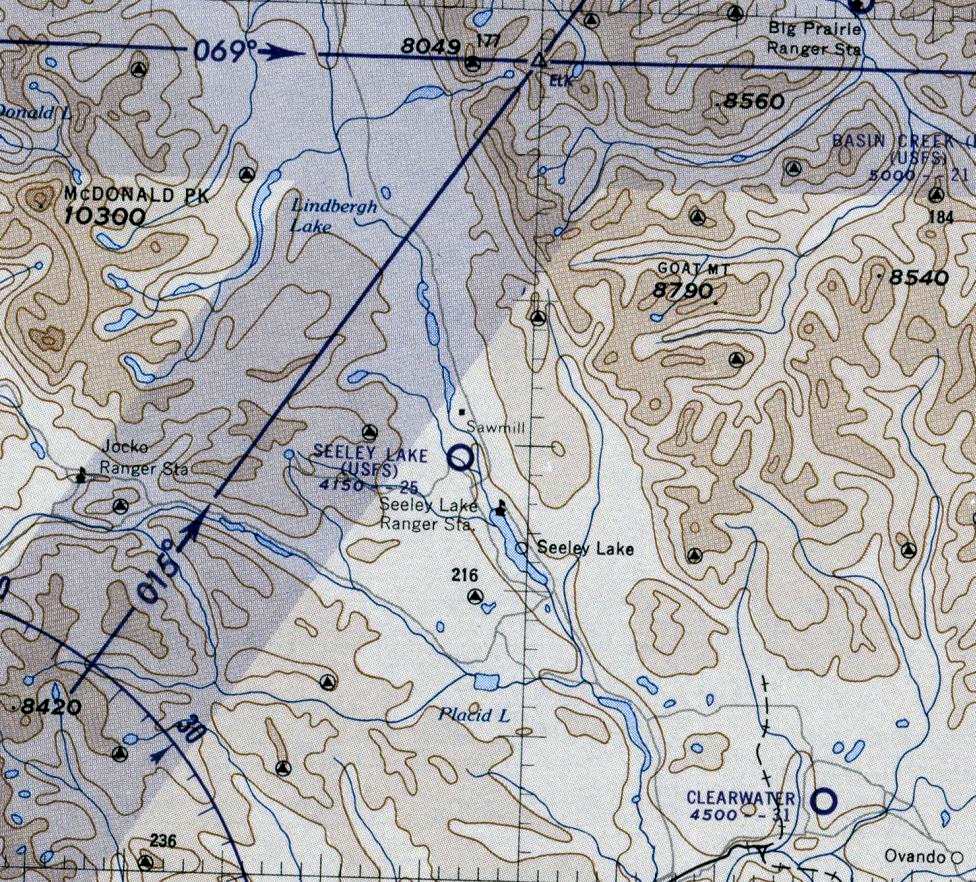
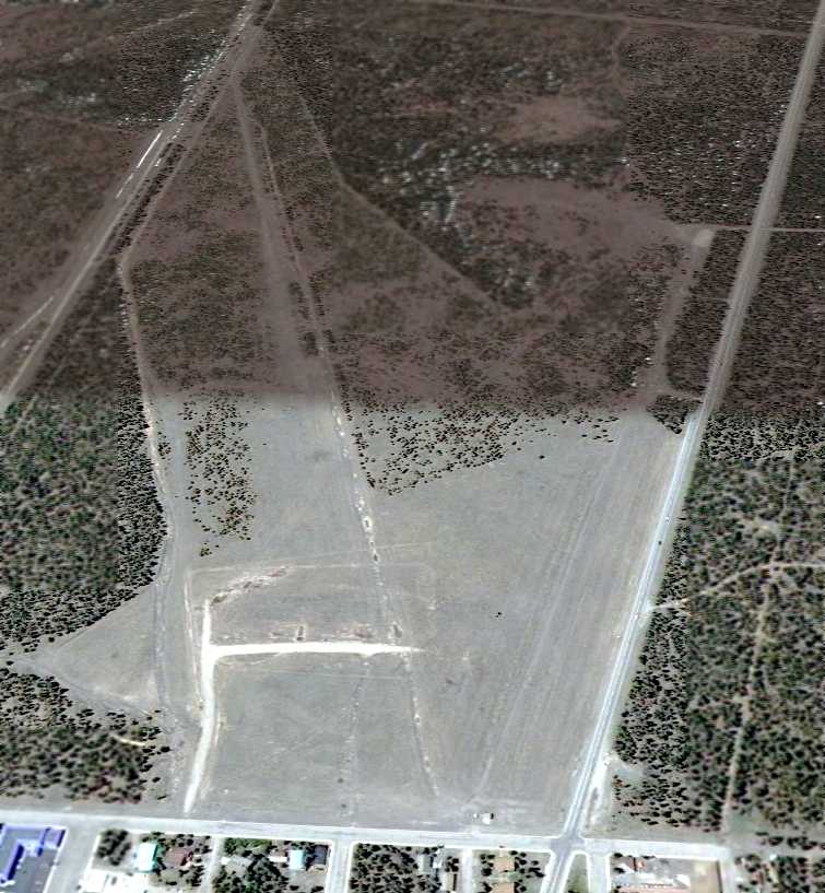
Seeley Lake USFS Airfield (original location), Seeley Lake, MT
47.24, -113.56 (Northeast of Missoula, MT)
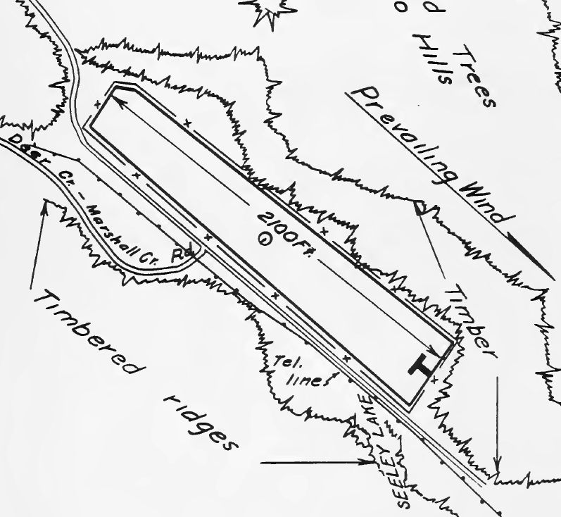
Seeley Lake Airfield, as depicted in the 1939 U.S. Forest Service “Airplane Landing Fields” (courtesy of Rich Finkle).
The original airfield for the town of Seeley Lake was the Seeley Lake United States Forest Service Airfield several miles northwest of the lake.
The date of establishment of the Seeley Lake USFS Airfield has not been determined.
The earliest depiction which has been located of the Seeley Lake USFS Airfield
was in the 1939 U.S. Forest Service “Airplane Landing Fields” (courtesy of Rich Finkle).
It depicted Seeley Lake Airfield as having a 2,100' northwest/southeast runway.
Seeley Lake Airfield was not yet depicted on the April 1944 Butte Sectional Chart.
The earliest aeronautical chart depiction which has been located of the Seeley Lake Airfield was on the May 1945 Butte Sectional Chart.
It depicted Seeley Lake as an auxiliary airfield.
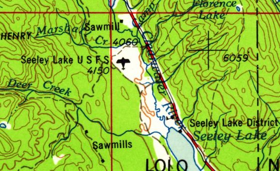
Seeley Lake United States Forest Service Airfield, as depicted on the 1958 USGS topo map.
The last aeronautical chart depiction which has been located of the original location of the Seeley Lake Airfield (northwest of Seeley Lake) was on the October 1960 Butte Sectional Chart (courtesy of Scott Newpower).
It depicted “Seeley Lake (USFS)” as having a 2,500' unpaved runway.

The earliest photo which has been located of the Seeley Lake USFS Airfield was a 7/25/64 USGS aerial view looking north.
It depicted a single unpaved northwest/southeast runway.
The original Seeley Lake Airfield (northwest of Seeley Lake) was apparently replaced at some point between 1960-65,
as it was no longer depicted on the February 1965 Butte Sectional Chart,
having been replaced by a Seeley Lake Airfield to the southeast of Seeley Lake.
A 1995 USGS aerial view looking north depicted the Seeley Lake USFS Airfield as having a single unpaved northwest/southeast runway.
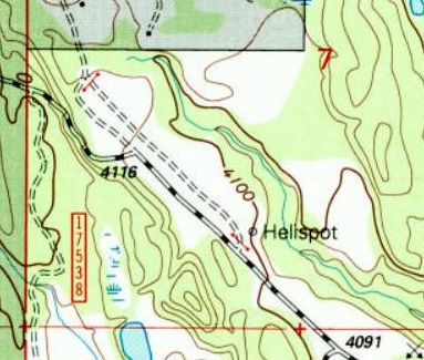
The 1999 USGS topo map still depicted the northwest/southeast clearing of the Seeley Lake USFS Airfield,
but only depicted the “Helispot” at the southeast end.
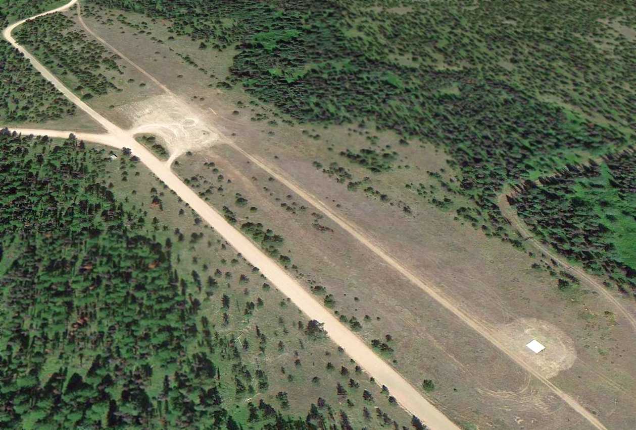
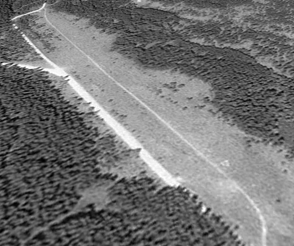
A 2013 aerial view looking north depicted Seeley Lake USFS Airfield as having a single unpaved northwest/southeast runway, with a helipad on the southeast end.
Scott Newpower reported in 2015, “The locals today call it the heliport
because this is where the emergency helicopters from Missoula will land when somebody hurts themselves while snowmobiling.
At midfield you will see a parking area, this is where people park their trucks & unload snowmobiles.”
The site of Seeley Lake USFS Airfield is located east of the intersection of Fawn Creek Road & Sawbuck Trail.
Thanks to Scott Newpower for pointing out this airfield.
____________________________________________________
(Original) Missoula Airport / Garden City Airport / Hale Field, Missoula, MT
46.84, -114.01 (Southwest of Downtown Missoula, MT)
The original Missoula Airport, as depicted on the August 1935 Butte Sectional Chart.
According to the Missoula International Airport website, “In 1927 a group of men meet at the Palace Hotel to discuss Missoula's future in aviation.
Missoula, it was felt, needed an airport to succeed.
City businessman Harry Bell was elected president of the Missoula chapter of the National Aeronautic Association.
Their first act was to secure an airmail route to Butte & Salt Lake City.
Walter Beck secured a 60-day option on 80 acres of land just east of the Missoula County Fairgrounds.
The County officially purchased the 80 acres, along with an adjacent strip to construct an east/west runway.
Total cost was $5,000. A northwest/southeast runway was later built.”
According to the Missoula International Airport website, “In 1929, through additional financing secured by Harry Bell & state Senator John Campbell,
Missoula’s Garden City Airport now covered 225 acres.”
The earliest depiction which has been located of the original Missoula Airport was on the August 1935 Butte Sectional Chart.
According to the Missoula International Airport website, “In 1935 the Garden City Airport was officially named Hale Field,
after county surveyor & civil engineer Dick Hale, who spent many hours at the airport as an aviation enthusiast.”
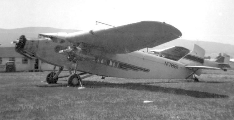
The earliest photo which has been located of Hale Field was a circa 1930s photo
of a Ford 4-AT-B Tri-Motor (N7861 c/n 4-AT-46) at Hale Field's Johnson Flying Service.
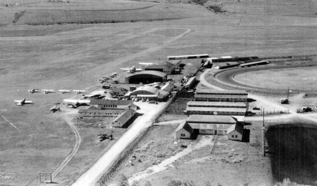
A circa 1945 aerial view looking south showing a considerable number of planes & hangars at Hale Field.
Charles Bloom noted, “You will see in the lower left part a military 'Hellcat' [Grumman F6F] parked on the turf.
That was given to the airport by the military after WWII. The military just flew in it, gave it to the city & left.
I was 9 or 10 years old at the time & used to ride my bicycle out to the field & play in the plane.”
According to the Missoula International Airport website, “In 1949, Hale Field continued to grow.
Located at the airport were a new & modern maintenance facility, 3 large hangars, 2 T-hangars, offices,
a cafe, carpenter shop, a parachute loft, a classroom, and 32 aircraft.”
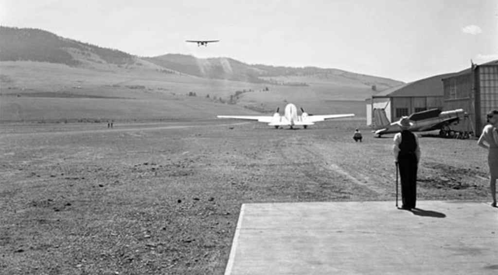
A 4/29/47 photo Hale Field, showing a Ford Tri-Motor taking off, along with a DC-2 or DC-3, and a surplus Vultee BT-13.
The last aeronautical chart depiction which has been located of Hale Field was on the April 1950 Butte Sectional Chart.
It depicted Hale as having a 3,800' unpaved runway.
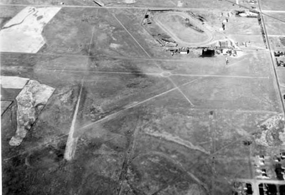
A 1950 aerial view looking west showed Hale Field to have 4 unpaved runways, with several buildings & hangars.
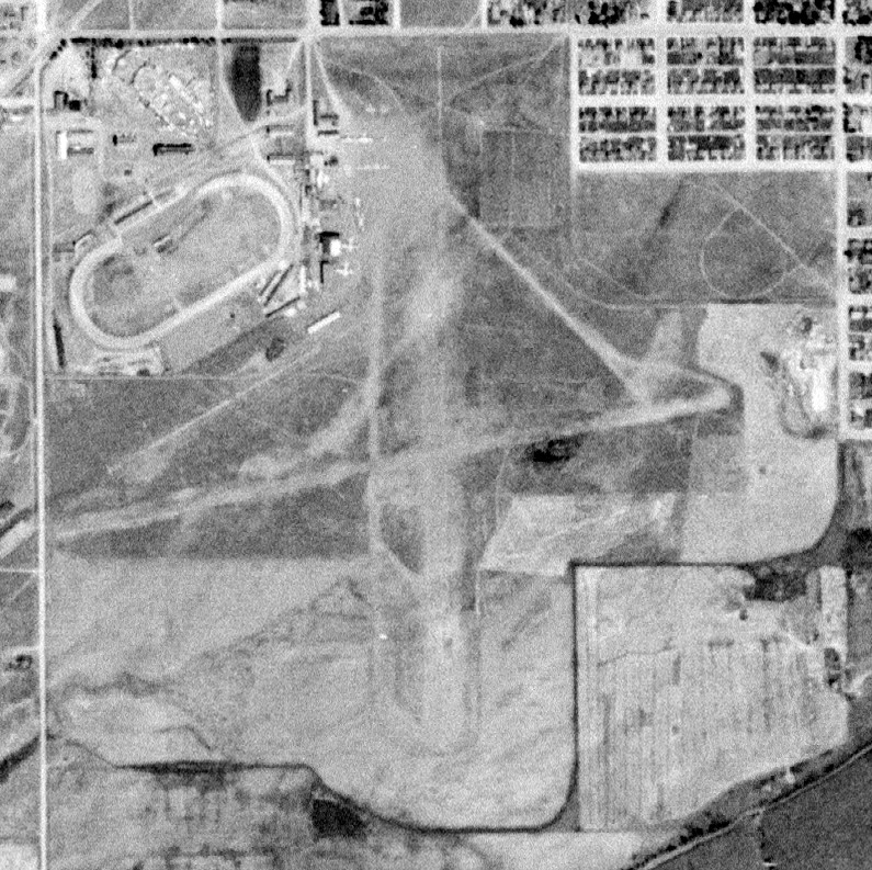
The last photo which has been located of Hale Field was a 10/26/54 USGS aerial view.
It showed the field to have 2 unpaved runways, with at least 4 aircraft parked near several buildings & hangars on the northwest side.
According to the Missoula International Airport website, “In 1954, Hale Field closed its runways forever.”
Hale Field was no longer depicted on the October 1955 Butte Sectional Chart.
The 1964 USGS topo map showed Sentinel High School & Playfair Park occupying the site of Hale Field.
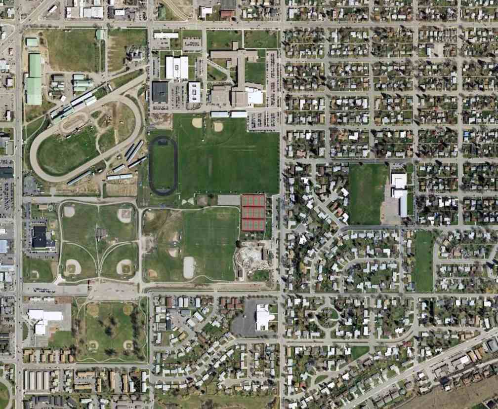
A 4/19/06 aerial view showed no recognizable trace remaining of Hale Field.
According to the Missoula International Airport website, “The former airport property is now the site of Sentinel High School, Playfair Park, and Splash Montana Waterslide Park.”
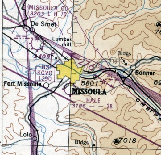
The site of Hale Field is located southwest at the intersection of South Avenue & Bancroft Street.
Thanks to Micheal McMurtrey for pointing out this airfield.
____________________________________________________
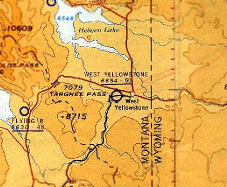
West Yellowstone Airport, West Yellowstone, MT
44.66, -111.12 (Southeast of Butte, MT)
A 1933 proposal showing the plans for 2 runways at West Yellowstone (courtesy of Jonathan Westerling).
According to Jonathan Westerling, “The original airfield for West Yellowstone & Yellowstone National Park dates to 1933
when the owner of the local general store Sam Eagle applied to the Forest Service to establish an airfield just to the west of town.”
The Forest Service’s initial return letter was encouraging,
“...ordinarily the Forest Service considers the use of National Forest land for airplane landing fields not undesirable.”
The earliest depiction which has been located of the West Yellowstone Airport
was a 1933 proposal (courtesy of Jonathan Westerling) showing plans for 2 runways.

The earliest map depiction which has been located of the West Yellowstone Airport
was on a 1934 ID Department of Public Works Airport Map of Idaho (courtesy of Chris Kennedy).
According to an article written by Sam’s son Walter Eagle in 1948,
“Perhaps one of the most amazing projects was the building of a mile-long airport at the west end of town
which was cleared out of some of the thickest forest in the entire area.”
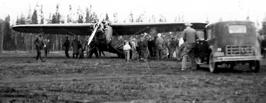
A 1935 photo of throngs of people & vehicles approach the first plane (a Hamilton Metalplane) to land at the new airfield on the day of its dedication
(courtesy of the Yellowstone Historic Center archives, Eagle Family Collection, via Jonathan Westerling).
According to an article written by Sam’s son Walter Eagle in 1948,
the West Yellowstone Airport “was dedicated & officially opened on 6/22/35
and regular mail & passenger service was begun by the National Park Airways [later Western Airways].
The citizens of West Yellowstone Citizens initially pledged $1,000 for the Airport.
The Final Cost Exceeded $20,000.”
A 10/23/34 newspaper article told of the first airplane landing at the field:
“F. H. Christesen, Idaho pilot, set the first plane down on the long strip of graded runway
which the people of West Yellowstone have carved out of the timbered plain.
He was heartily welcomed & spent most of the day taking passengers into the air in the 7-passenger cabin Faulkner.”
The 1936 Descriptions of Airports & Landing Fields in the US (according to Jonathan Westerling) has the following entry for the airport:
“West Yellowstone, auxiliary airfield.
Adjoins West Yellowstone [City] on West between Tarhee Highway [U. S. Highway 20] & railroad.
Landing strip 5,000' x 500' Northeast/southwest surrounded by trees & no services.”
The earliest aeronautical chart depiction which has been located of the West Yellowstone Airport
was on the 1936 Sectional Chart (courtesy of Chris Kennedy).
It depicted West Yellowstone as an auxiliary airfield.
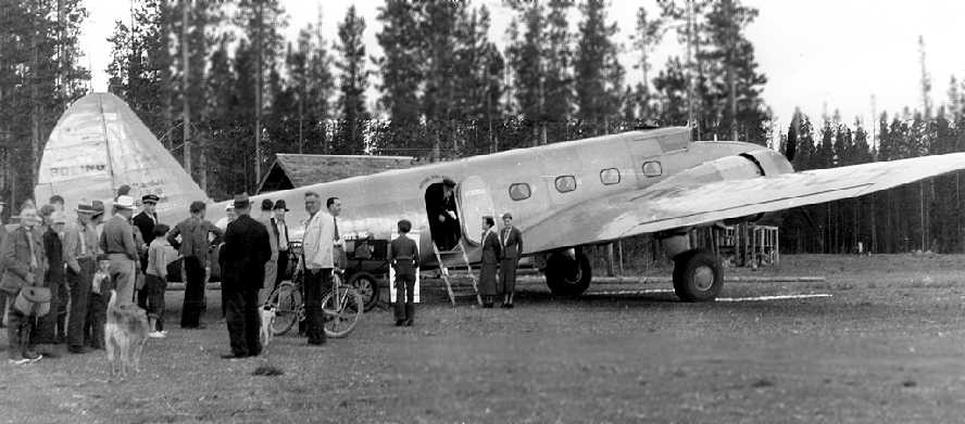
A circa 1930s photo of passengers boarding a Boeing 247 at West Yellowstone Airport
(courtesy of the Yellowstone Historic Center archives, Eagle Family Collection, via Jonathan Westerling).
The 1938 Descriptions of Airports & Landing Fields in the US (according to Jonathan Westerling)
added the addition of a smaller 4,000' northwest/southeast runway with a hangar & aviation fuel available (Summer only).
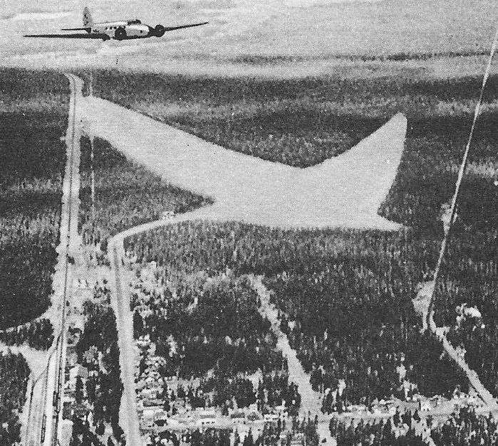
A circa 1930s postcard aerial view of Boeing 247 over West Yellowstone Airport (courtesy of the Gia Koontz).
The original caption read: “Yellowstone National Park is practically overnight from every important American city via National Parks Airways & connecting airlines.
Twin-motored, 10-passenger Boeing airplanes operated by National Parks Airways land at West Yellowstone Airport
from which the government entrance to Yellowstone National Park is only a 3-minute drive.”
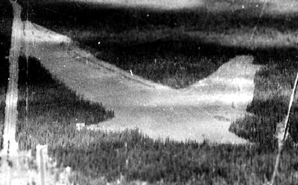
An undated aerial view looking northwest at West Yellowstone Airport
from The Airport Directory Company's 1938 Airport Directory (courtesy of Chris Kennedy).
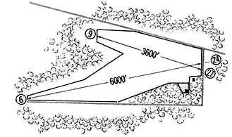
It described the field as having 2 gravel runways, with the longest being the 6,700' northeast/southwest strip.
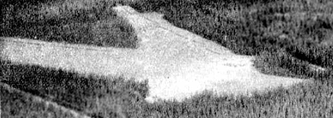
The 1939 U.S. Forest Service “Airplane Landing Fields” (courtesy of Rich Finkle)
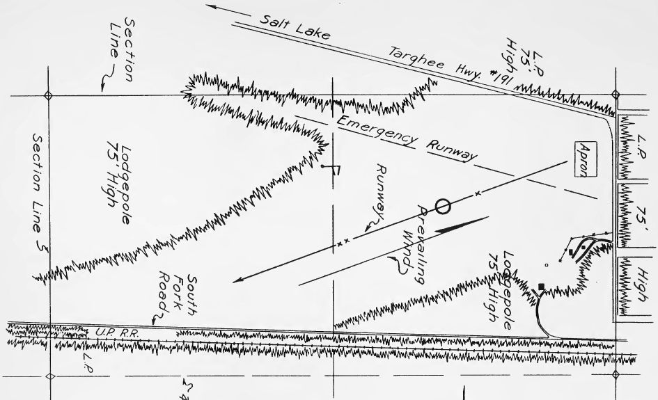
depicted West Yellowstone as having a northeast/southwest runway, along with a crosswind “Emergency Runway”.
A 1940 aerial view looking west at West Yellowstone Airport (courtesy of Jonathan Westerling),
showing the 2 grass runways.
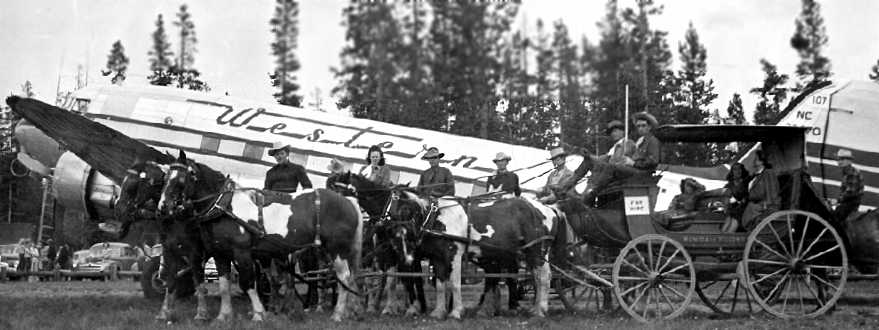
A circa 1940s photo of a Western DC-3 at West Yellowstone Airport (courtesy of Jonathan Westerling),
with an interesting juxtaposition of forms of transportation.
According to Paul Shea of the Yellowstone Historic Center the the airport was municipally-owned,
and saw both private flights as well as commercial DC-3 service from its opening through to the beginning of WWII.
A 3/14/46 USGS aerial view depicted “West Yellowstone Field” as having 2 grass runways, with a single building on the southeast side. There were no aircraft visible on the field.
According to Paul Shea of the Yellowstone Historic Center, the Yellowstone Airport reopened after WW2,
but shortly thereafter ceased passenger service because the runway was not long enough to allow the use of larger planes.
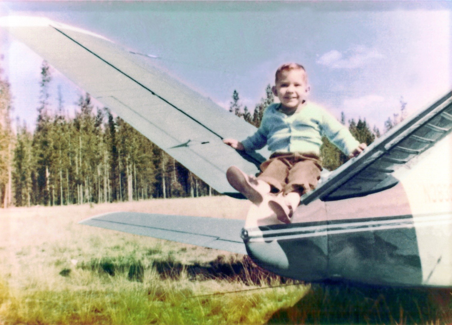
A circa 1955 photo of 3-year-old Terry Albertson sitting on the tail of a Beech 35 “Bonaza that suffered a mishap at the West Yellowstone Airport.”
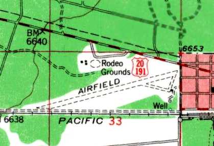
The 1958 USGS topo map (courtesy of Chris Kennedy)
depicted a single northeast/southwest runway, labeled simply as “Airfield”.
The former crosswind runway had evidently been replaced by a Rodeo Grounds.
According to an article by Colin Raff in the 8/22/59 Montana Standard,
the airport served as a vital connection for rescue flights after one of the largest earthquakes ever recorded in North America rocked the area:
“Overhead, planes & helicopters drone continuously in the air.
The West Yellowstone airport is seeing more activity than it ever anticipated,
and the field is literally filled with aircraft, ranging from a giant Air Force Grumman Albatross
to helicopters of varying sizes to Piper Cubs.
Planes & copters take off & land with almost as much regularity as one would expect at New York's busiest terminals.”
The 1960 Jeppesen Airway Manual (courtesy of Chris Kennedy)
depicted West Yellowstone as still having 2 runways,
even though the 1958 USGS topo map had depicted Runway 9/27 as having been covered by a Rodeo Grounds 2 years previously.
The last aeronautical chart depiction which has been located of the West Yellowstone Airport
was on the 1961 Sectional Chart (courtesy of Chris Kennedy).
It depicted West Yellowstone as having a 6,000' unpaved runway.
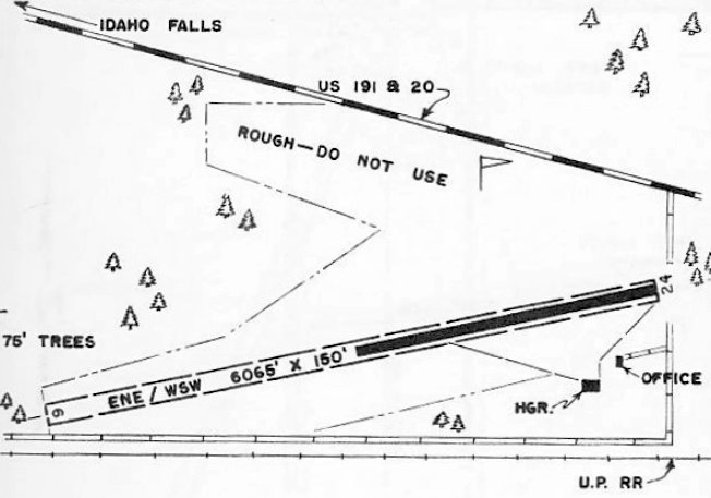
The 1963 MT Airport Directory (courtesy of Ted Mathis) depicted West Yellowstone Airport as having a 6,065' Runway 6/24,
of which the eastern half was paved, and a hangar & office to the southeast.
According to Jonathan Westerling, “Due to the limited length of the runway at the original airport,
the city built a new airport in 1964”, north of the town.
The original Yellowstone Airport was presumably closed at this point.
Only the new Yellowstone Airport (north of the town) was depicted on the June 1965 Yellowstone Park Sectional Chart (courtesy of Ron Kunse).
A circa early-1970s aerial view of the east end of the former West Yellowstone Airport (courtesy of Roger Mackenzie, via Jonathan Westerling).
Terry Albertson recalled, “It is possible that I am the last pilot to land an airplane on the turf at the closed West Yellowstone Airport.
In the mid-1970s, I was a flight instructor at the new airport, and I would give my students simulated engine failures after takeoff.
We would sometimes actually land at the old airport as part of the simulated emergency (it had been closed for 10 years at that time).”
Mark Andrews reported, “West Yellowstone Airport... It was used as a firejumper base during the 1988 Yellowstone Park fires.
This was the site of many scenes of the 1989 Steven Spielberg film 'Always'.”
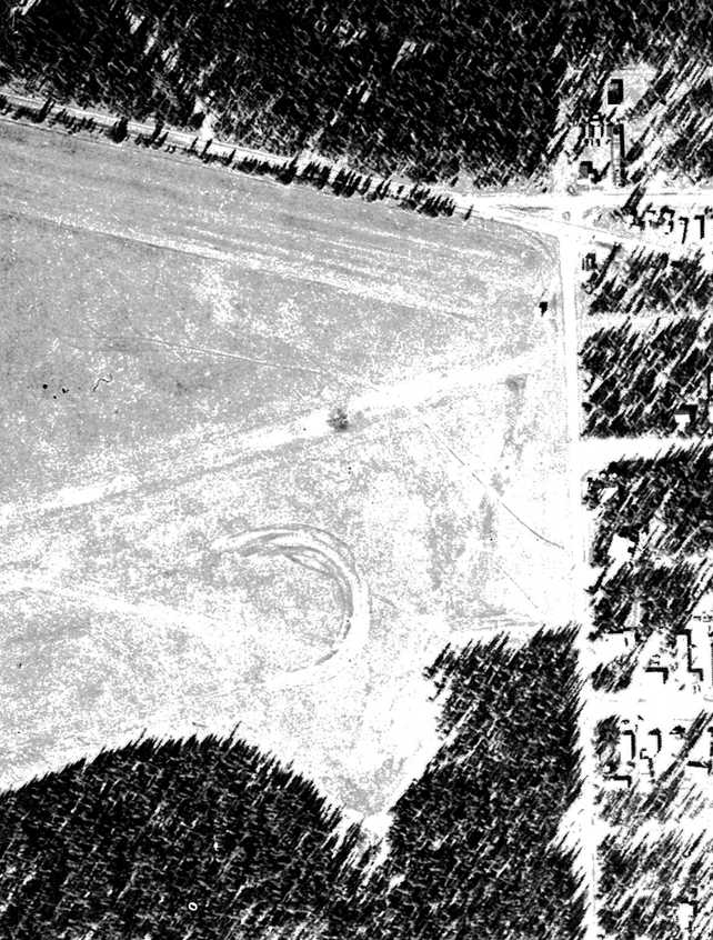
The 1999 USGS aerial photo (courtesy of Jonathan Westerling),
Jonathan remarked, “shows the area still remarkably clear of vegetation almost 50 years after the airfield closed.
South of the western end of the cross runway,
it is possible to make out a white circle which could be the remnants of the segmented circle which marked the airport in its early days.”
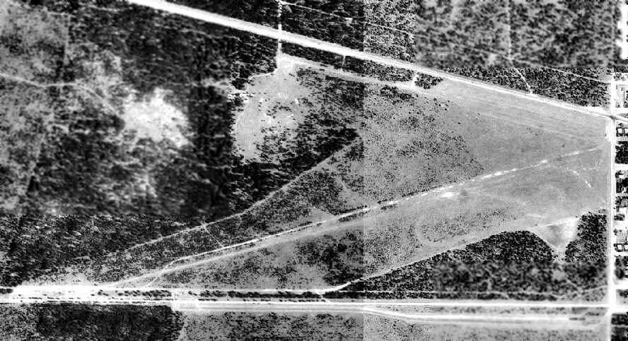
A 2005 aerial view looking west showed the 2 former West Yellowstone Airport runways.
According to Paul Shea of the Yellowstone Historic Center as of 2008 the former airport land was government-owned
and a portion was leased to a tire manufacturing company to test its products there during the winter.
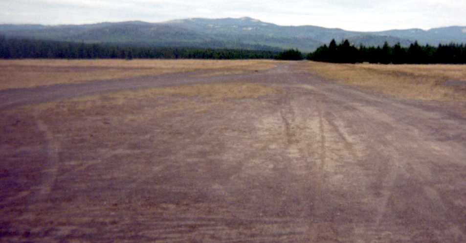
A 2008 photo by Roger Mackenzie (courtesy of Jonathan Westerling) looking along the former runway at West Yellowstone.
Jonathan reported that “There were no buildings standing on the airport grounds.”
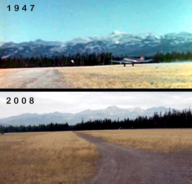
A comparison by Jonathan Westerling of a 2008 view of the site of West Yellowstone Airport
with the same location from a 1947 movie showing a DC-3 departing to the north on the field.
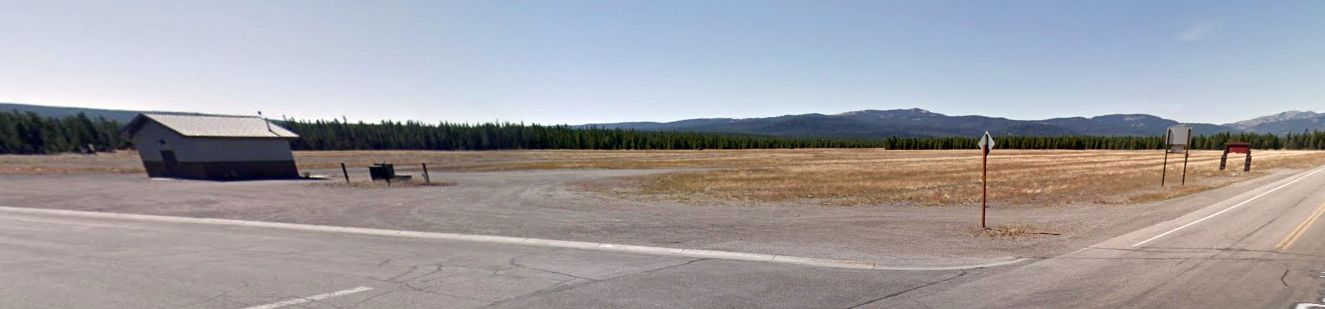
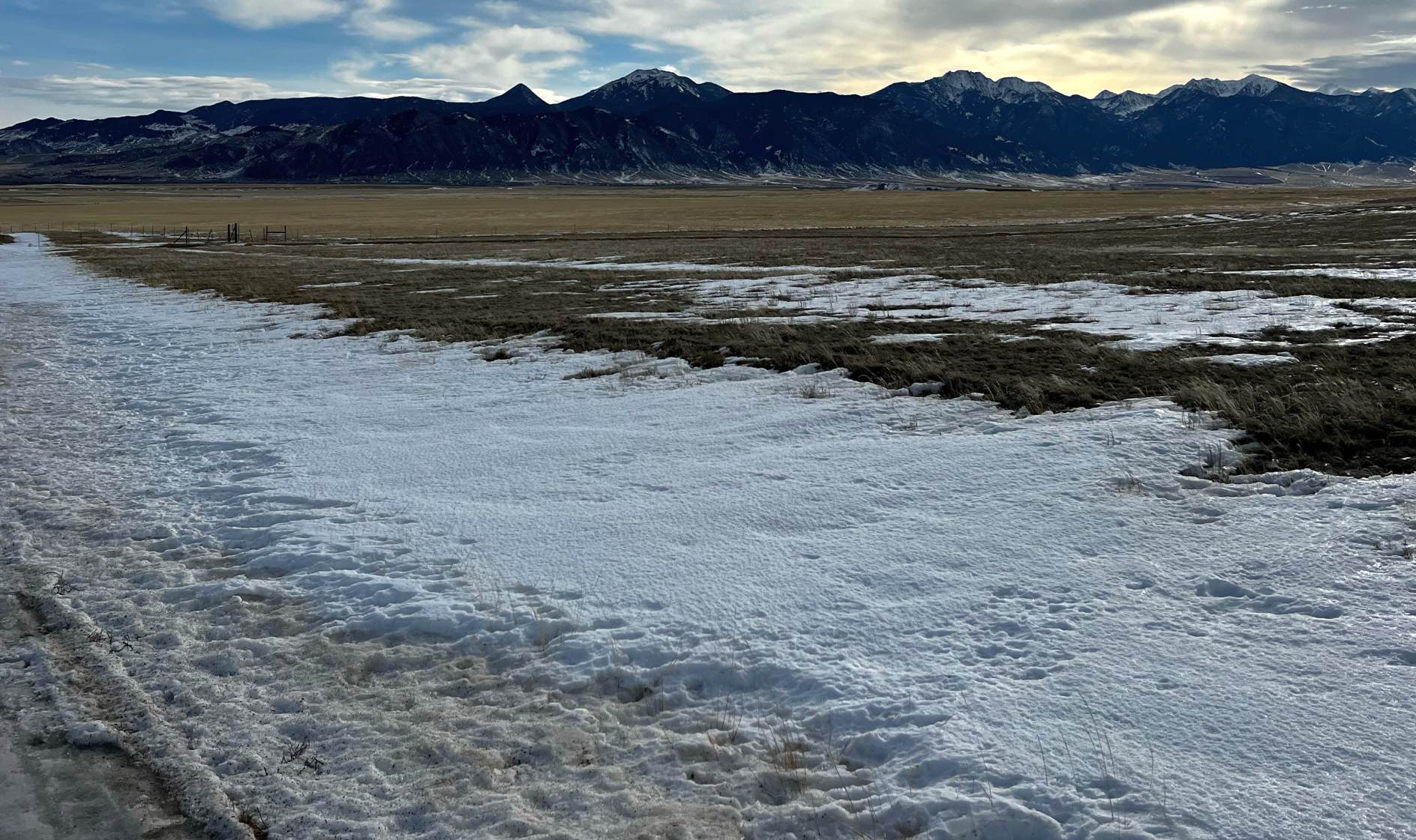
A September 2015 photo looking southwest at the site of West Yellowstone Airport.
The site of the West Yellowstone Airport is located southwest of the intersection of Route 20 & West Iris Street.
____________________________________________________
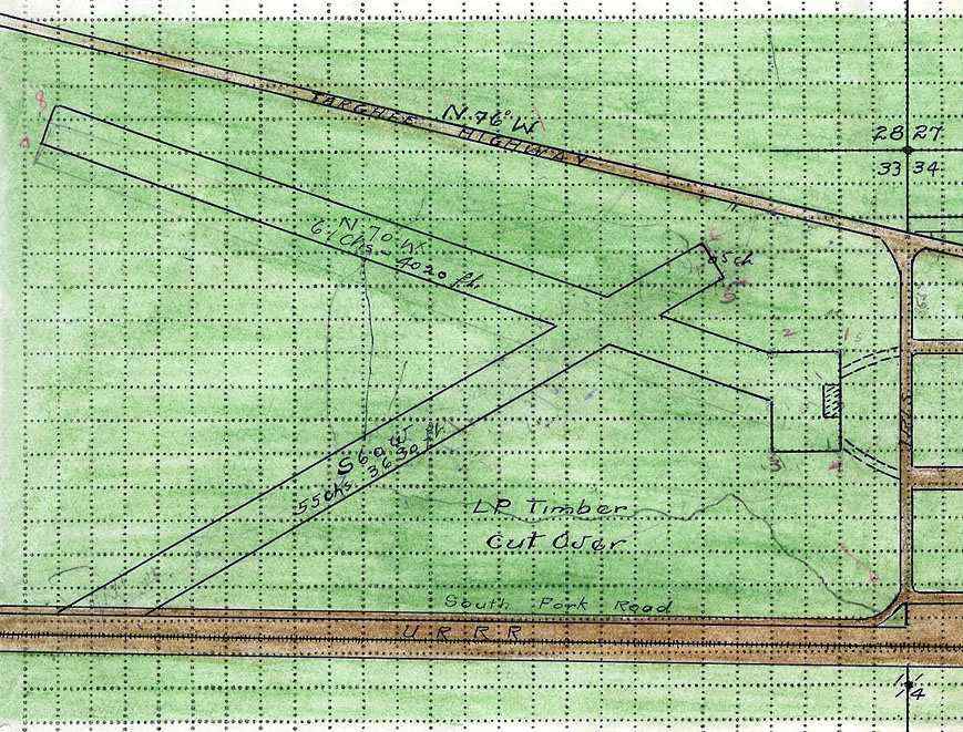
Whitehall Intermediate Field, Whitehall, MT
45.81, -112.21 (Southeast of Butte, MT)
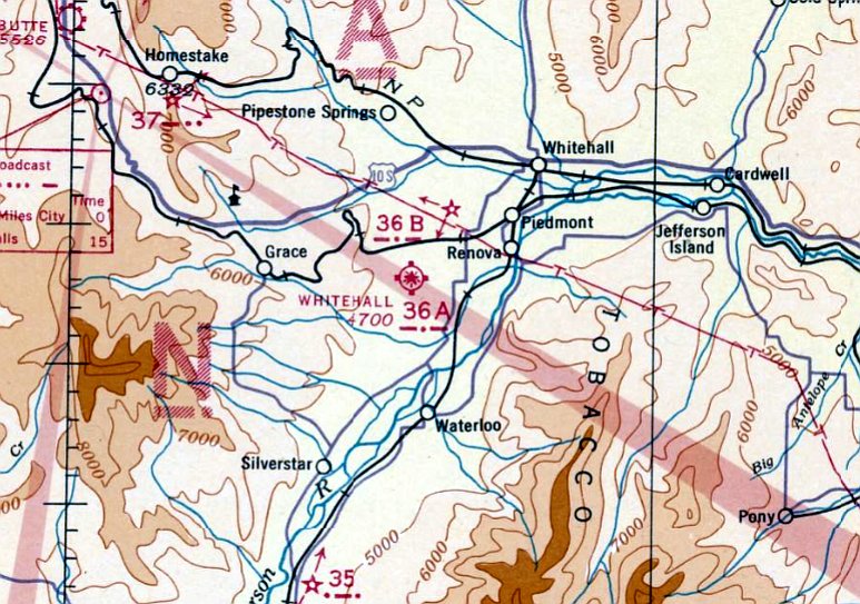
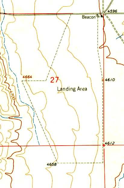
Whitehall Intermediate Field, as depicted on the February 1936 Yellowstone Sectional Chart.
Photo of the airport while open has not been located.
The Whitehall Intermediate Field was established by the Department of Commerce
as one of their network of landing fields constructed for the emergency use
of commercial aircraft flying along airways between major cities.
The date of construction of the Whitehall Intermediate Field has not been determined.
The earliest reference which has been located to Whitehall Intermediate Field
was in The Airport Directory Company's 1933 Airport Directory (courtesy of Chris Kennedy).
It described Whitehall “Site 35” as a Department of Commerce Intermediate Field along the Salt Lake – Great Falls Airway.
The field was said to consist of a 161-acre L-shaped gravel field containing 2 runways” 3,960' north/south & 3,300' east/west.
The earliest depiction which has been located of Whitehall Intermediate Field was on the February 1936 Yellowstone Sectional Chart.
It depicted Whitehall as “Site 36A”.
The February 1942 2M Regional Aeronautical Chart (courtesy of Chris Kennedy) depicted Whitehall as “Site 36A”.
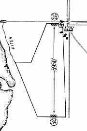
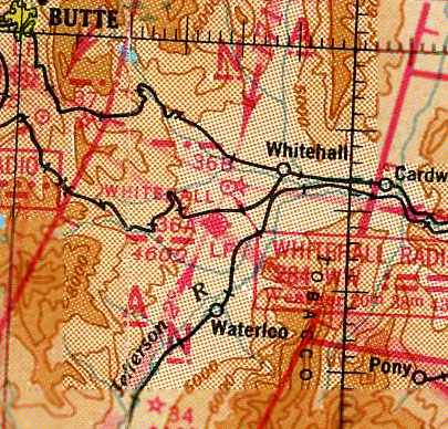
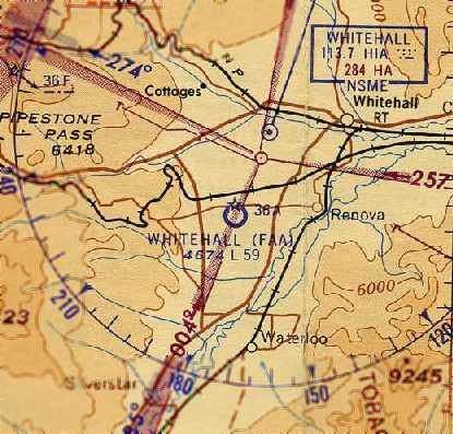
The 1960 Jeppesen Airway Manual (courtesy of Chris Kennedy) depicted the “Whitehall FAA” Airfield as having a single 5,950' unpaved Runway 16/34 within an irregularly-shaped landing area.
Several buildings were depicted on the northeast corner of the field, but it is not known if these were airfield-related.
The last aeronautical chart depiction which has been located of the Whitehall Airfield was on the April 1961 Yellowstone Park Sectional Chart (courtesy of Chris Kennedy).
It depicted “Whitehall (FAA)” as having a 5,900' unpaved runway.
The last directory listing of Whitehall which has been located was in the 1963 AOPA Airport Directory (according to Chris Kennedy).
The earliest topo map depiction which has been located of Whitehall Intermediate Field was on the 1963 USGS.
It depicted the outline of the airfield, labeled simply as “Landing Area”.
It also depicted an airway beacon & a few small buildings at the northeast corner of the field.
Whitehall apparently lasted longer than most other rural Intermediate Fields.
It was evidently closed (for reasons unknown) at some point between 1963-65,
as it was no longer listed among active airfields in the 1965 Jeppesen Airway Manual (according to Chris Kennedy).
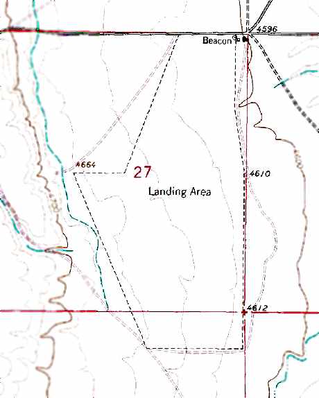
The 1996 USGS topo map still depicted the outline of the Whitehall airfield, labeled simply as “Landing Area”.
It also still depicted an airway beacon & a few small buildings at the northeast corner of the field.
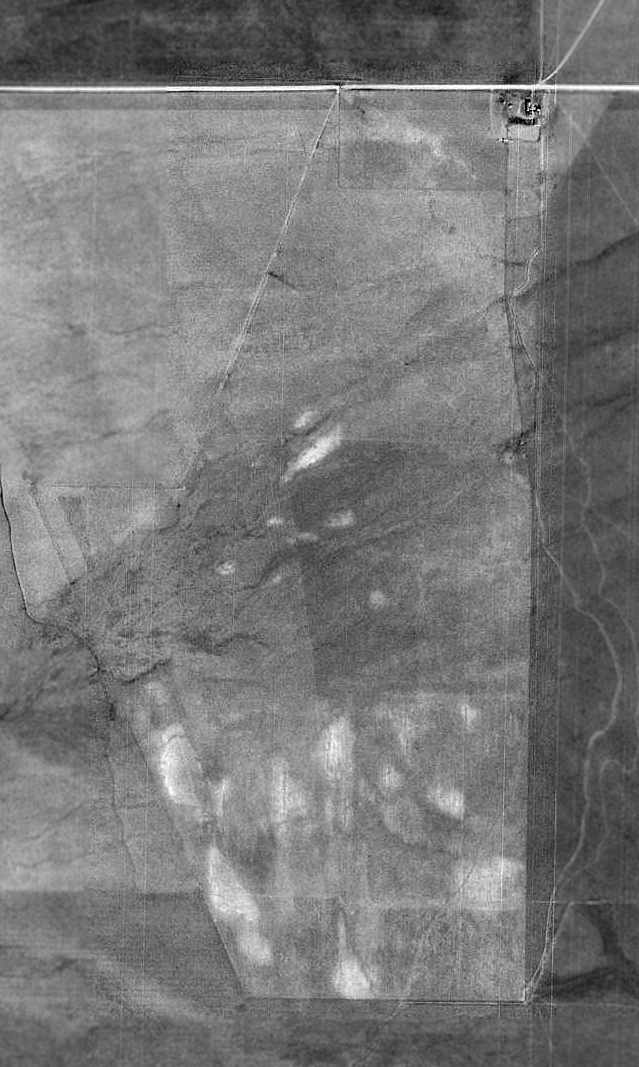
As seen in the 1995 USGS aerial photo, the outline of the former Whitehall Intermediate Field remains distinct.
Several buildings remain at the northeast corner of the airfield, possibly including the airway beacon depicted on the topo map.
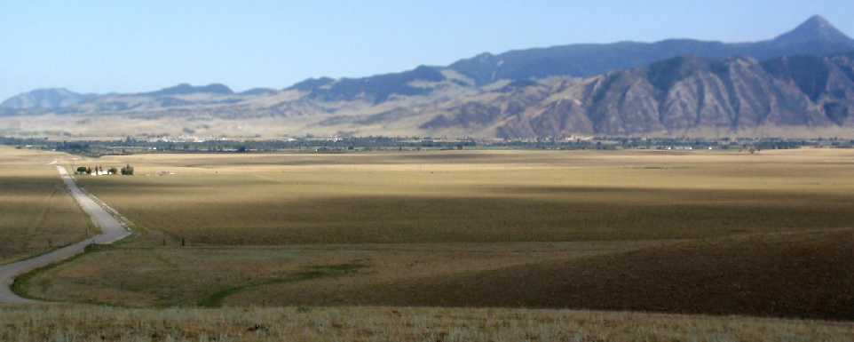
A 2009 photo by Al Nash, looking southeast at the site of Whitehall Intermediate Field, taken from a small rise to the northwest.
Al reported, “If you look hard along the road about the middle of the image,
you can see the fence posts which mark the rude gate leading into the dirt 2-track road which shows up on the 1996 USGS topo and the 1995 aerial photo.”
A 2009 photo by Al Nash, looking southeast at the most northwesterly of the several buildings at the site of Whitehall Intermediate Field.
Al reported, “I never saw an Airway Beacon, but the size, age and design of these 2 small buildings suggest they may have been [related to the beacon].”
A 2014 aerial photo showed the outline of the former Whitehall Intermediate Field remains distinct.
A 12/26/22 photo by Colin Graham of the site of Whitehall Intermediate Field.
Colin Graham observed, “There's no real trace left. You’d never know anything was ever there.”
The site of the Whitehall Intermediate Field is located southeast of the intersection of Route 41 & Airport Lane, appropriately enough.
____________________________________________________
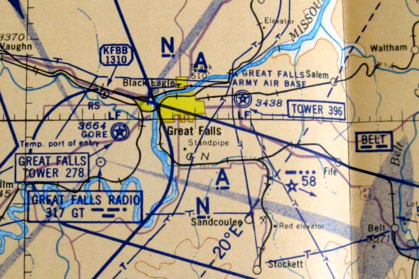
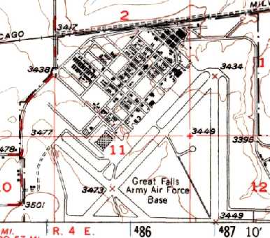
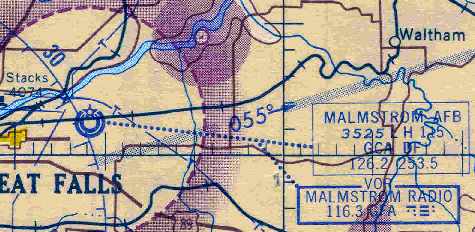
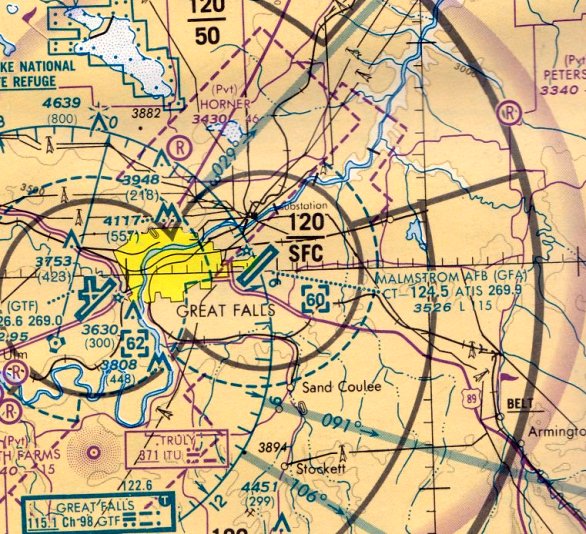
Great Falls AAF / Malmstrom AFB (GFA), Malmstrom, MT
47.5, -111.19 (North of Billings, MT)
Col. Ford Laure making the 1st B-17 landing at Great Falls Army Air Base on 11/30/1942.
This is a fairly unusual (although not unique) case of a base that continues to be an active Air Force installation (as of 2002)
even though its huge airfield has been abandoned.
Malmstrom Air Force Base traces its beginnings back to 1939 when WW2 broke out in Europe.
Concern about the war caused the local Chamber of Commerce to contact 2 Montana senators,
Burton Wheeler & James Murray, and request they consider development of a military installation in Great Falls.
In 1942, a survey team evaluated an area near the Green Mill Dance Club & Rainbow Dam Road approximately 6 miles east of Great Falls.
Great Falls, along with ten other northern tier sparsely populated sites, was considered for a heavy bomber-training base.
Construction began on Great Falls Army Air Base in 1942.
As constructed during the war, the airfield consisted of 4 paved runways, taxiways,
a large paved ramp area, numerous hangars, and a large number of other buildings.
The base was informally known as East Base since the 7th Ferrying Group was stationed at the Municipal Airport on Gore Hill.
Its mission was to establish an air route between Great Falls & Ladd Field, Fairbanks, Alaska,
as part of the US Lend-Lease Program that supplied the Soviet Union with aircraft & supplies needed to fight the German Army.
The earliest depiction which has been located of Great Falls Army Air Base
was an 11/30/1942 photo showing Col. Ford Laure making the 1st B-17 landing at the base.
Great Falls Army Air Base was assigned to 2nd Air Force.
Four Bombardment Groups, the 2nd, 385th, 390th, and 401st, trained at Great Falls from November 1942 to October 1943.
Group Headquarters & one of the Groups' 4 squadrons were stationed in Great Falls.
These bombardment groups went on to participate in decisive raids over Germany
opening the door for Allied daylight precision bombing.
Upon completion of the B-17 training program in 1943, Great Falls AAB was transferred to the Air Transport Command
and units from Gore Field transferred to the base.
More buildings were constructed this year, including a consolidated mess, a Post Exchange, a theater, and a 400-bed hospital.
Moreover, the Lend Lease Program continued, which included deliveries of P-39, C-47, B-25, and A-20 aircraft.
B-25 Mitchell Bombers arrived by rail & were assembled on base,
while others were flown in by both military & Women Air Force Service Pilots (WASPs).
These aircraft were later flown by US pilots to Fairbanks, Alaska,
and transferred to Russian pilots who in turn flew them into Siberia.
A total of 1,717,712 pounds of cargo containing aircraft parts, tools miscellaneous equipment,
explosives & medical supplies were shipped through Great Falls AAB to Russia.
The earliest aeronautical chart depiction which has been located of Great Falls Army Air Base was on the 1943 Butte Sectional Chart.
Aircraft shipments to the Soviet Union through Great Falls AAF stopped in 1945 with the end of WW2,
with approximately 8,000 aircraft having been processed in a 21-month period.
The earliest aerial photo which has been located of Great Falls AAB was a 7/10/46 USGS aerial view.
It depicted the field as having 4 paved runways.
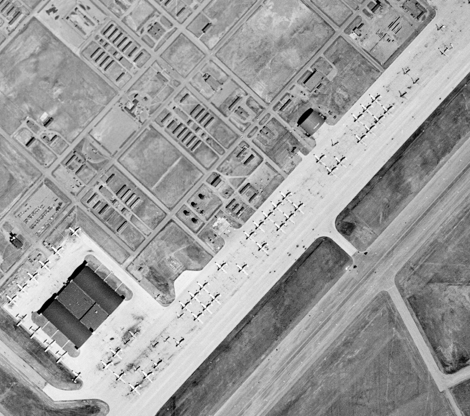
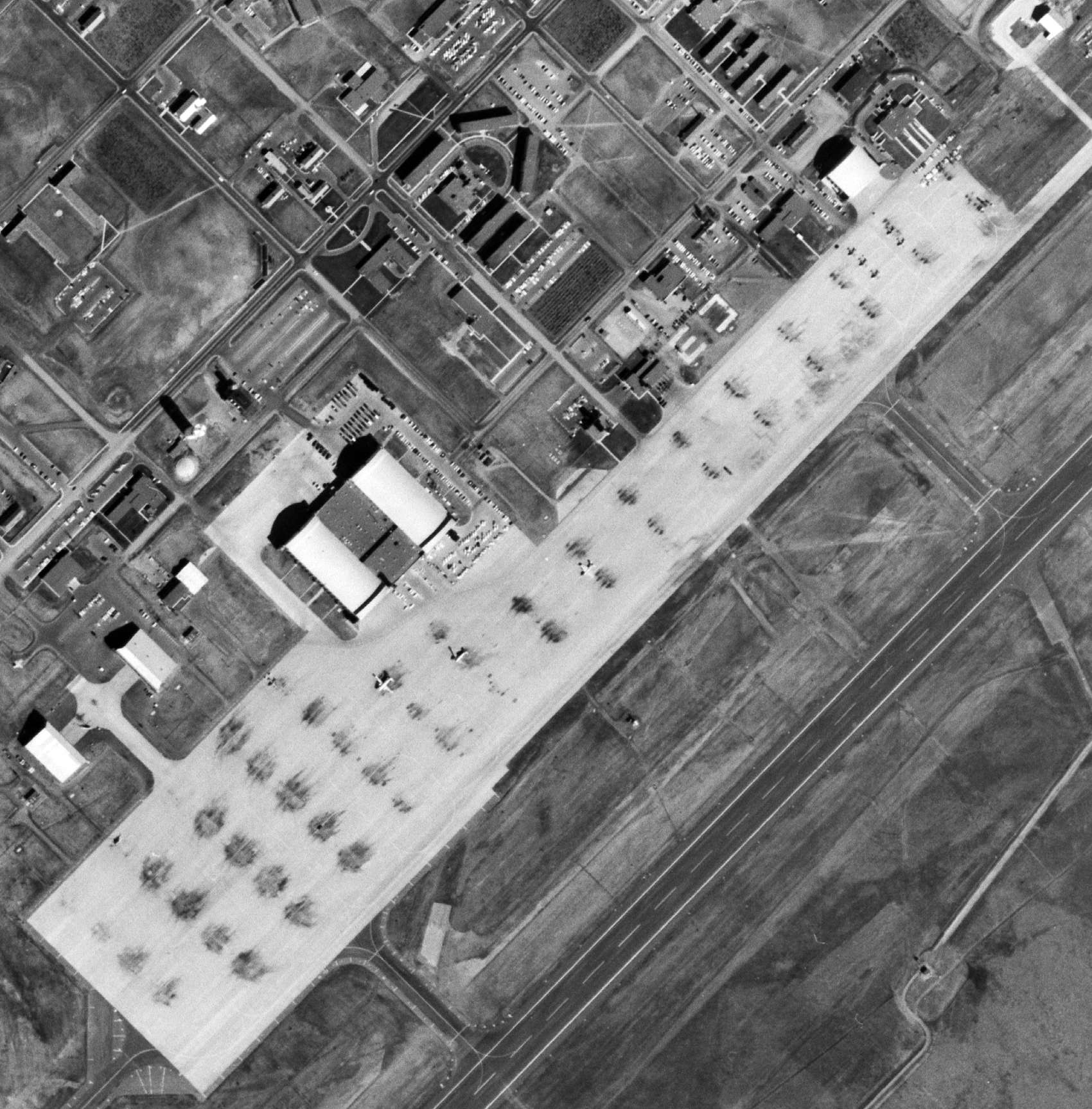
A closeup of Great Falls AAB from the 7/10/46 USGS aerial view, showing a huge number of large military aircraft (type unidentified) stored on the field in the post-WW2 drawdown.
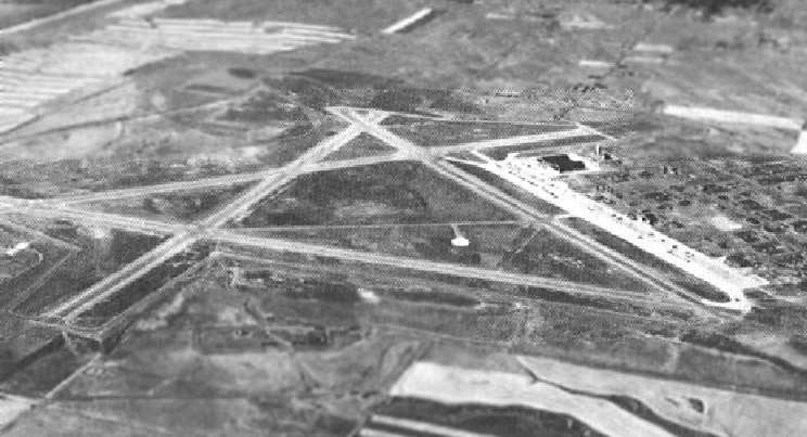
A circa mid-1940s aerial view looking west at Great Falls Army Air Base.
Following WW2, Great Falls AAB assumed a support mission for military personnel assigned to Alaskan military installations.
A reserve training unit was established here for the 4th Air Force from 1946-47.
In 1947 the United States Air Force became a separate service
and the base’s name changed to Great Falls Air Force Base.
The 1948 USGS topo map still labeled the base as “Great Falls Army Air Force Base”.
It also still depicted the airfield in its WW2 configuration, with 4 paved runways.
The October 1948 Butte Sectional Chart (courtesy of Chris Kennedy)
depicted Great Falls AFB as having an 8,900' hard surface runway.
The "Cold War" was heating up when the Soviet Union closed all land travel between West Germany & West Berlin in 1948.
"Operation Vittles," the strategic airlift of supplies to Berlin's 2,000,000 inhabitants, was initiated.
Great Falls AFB played a critical role in assuring the success of this vital operation.
Officials selected the base as the only replacement aircrew training site for Berlin Airlift-bound C-54s,
officially activating the 517th Air Transport Wing.
Using radio beacons, Great Falls AFB was transformed to resemble Tempelhof Airport in Berlin, Germany.
Hundreds of pilots & Flight Engineers, many of whom were recalled to active duty,
were qualified on the C-54 aircraft & on flight procedures to & from Berlin
by practicing on ground mock-ups & flying simulated airlift missions.
Later, the 517th Air Transport Wing was redesginated the 1701st Air Transport Wing.
This wing's primary mission was the routing & scheduling of flights throughout the Pacific Ocean region
in support of allied forces in the Korean Conflict.
The Military Air Transport Service (MATS) reopened the C-54 Flight Training School
as the 1272 Medium Transition Training Unit in May 1950, one month before the Korean War began.
The 1701st ATW was later replaced by the 1300th Air Base Wing & the 582nd Air Resupply & Communications Squadron.
Great Falls AFB has also played a major aerial defense role in North American Air Defense mission.
The 29th Air Division activated at Great Falls AFB in early 1950,
bringing with them fighter interceptor squadrons, an aircraft control & warning squadron, and ground observer detachments.
The 29th Fighter Interceptor Squadron activated in 1953 & remained at Great Falls until 1968.
Malmstrom AFB was responsible for the 24th North American Aerospace Defense Command (NORAD) region,
which covered the western half of the North America.
This was comprised of 4 fighter-interceptor squadrons & radar sites
stretching from the Rocky Mountains, halfway across North Dakota & north to the north border of Canada.
The Malstrom Command Center (Building 500) was originally a Semi-Automatic Ground Environment facility,
which served as an alternate NORAD Command Center during the Cold War.
The 24th also served as the NORAD alternate command post, which remained active until 1983.
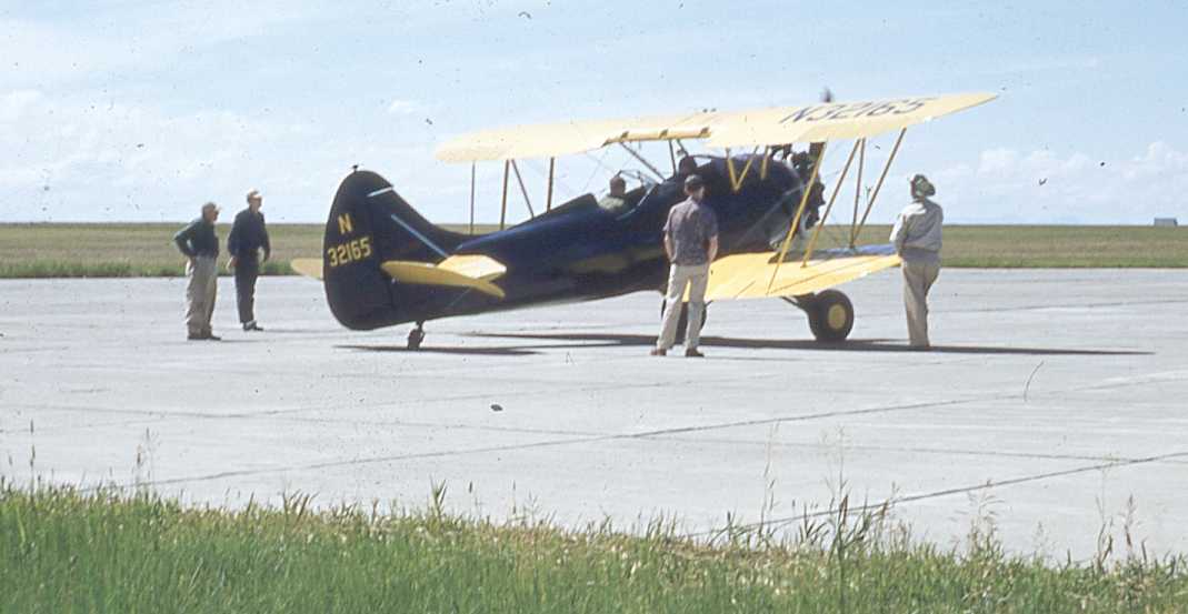
A circa 1950s photo of a Waco UPF-7 biplane at Malmstrom.
In 1954, the base was aligned under Strategic Air Command
and the 407th Strategic Fighter Wing was assigned to Great Falls AFB.
The Wing's F-84 fighters & KB-29 air refuelers were to provide fighter escort for SAC's long-range B-36 bombers.
In the same year, the 407th SFW Vice Commander, Col. Einar Malmstrom,
died when his T-33 crashed approximately one mile west of the airport at Gore Field.
Although his tenure was short, he was well liked by the local community.
It was the local civilian community that led the efforts to rename Great Falls AFB for Col. Malmstrom.
In 1956, the base was officially rededicated as Malmstrom AFB.
When the 407th SFW was deactivated in 1957, the 4061st Air Refueling Wing (ARW) was activated.
The 407th Air Refueling Squadron (ARS) and their KB-29s
were joined by the 97th ARS & their KC-97s to form the wing.
The 4061st ARW flew their missions from Malmstrom AFB until 1961.
The 341st Strategic Missile Wing was activated at Malmstrom AFB in 1961.
Construction of the wing's first launch facility was completed in 1961.
The first Minuteman I ICBM arrived on base by rail in 1962.
Just 4 days after the missile's arrival, Launch Facility Alpha-09 gained the title of the first Minuteman missile site.
In 1963, following 28 months of construction, the wing & its 3 squadrons became operational.
Each squadron controlled 50 missiles, bringing the total wing strength to 150 Minuteman I missiles.
Malmstrom's runway had apparently been lengthened at some point between 1948-63,
as the July 1963 Butte Sectional Chart (courtesy of Chris Kennedy) depicted Malmstrom AFB as having a 11,500' hard surface runway.
A 9/18/64 7/10/46 USGS aerial view depicted Malmstrom AFB as having a paved northeast/southwest runway, with the prior 3 WW2-era runways no longer active.
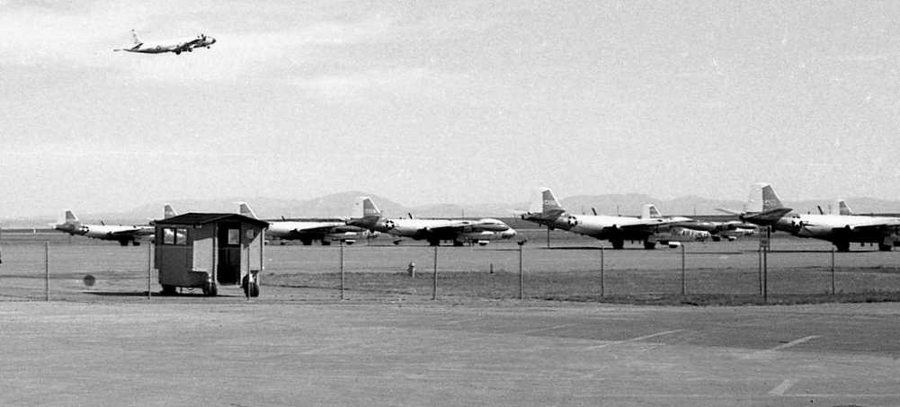
A closeup from the 9/18/64 7/10/46 USGS aerial view depicted only 3 aircraft on the huge Malmstrom AFB ramp.
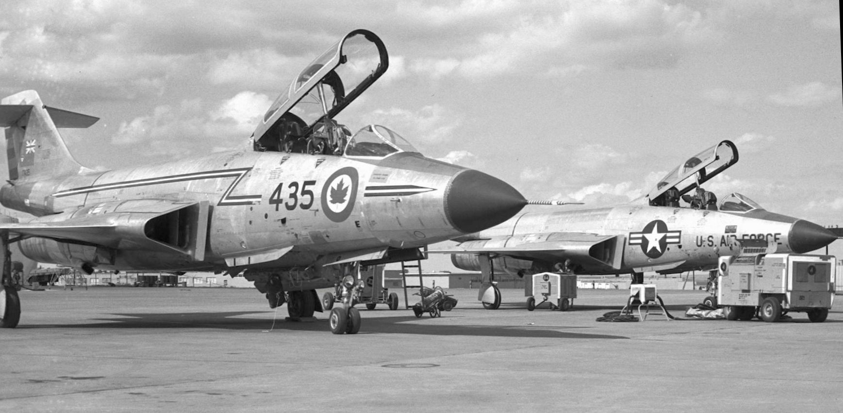
A 19664 photo of an RCAF McDonnell CF-101 Voodoo & a USAF F-101B Voodoo at Malmstrom.
In 1965 construction began on the 4th & final squadron, the 564th SMS.
This squadron was equipped with the more modern Minuteman II missiles.
Malmstrom's missile field was now the largest in the United States, covering 23,500 square miles.
By 1967, the 10th, 12th & 490th SMSs were also upgraded to the Minuteman II missiles,
increasing the wing's capabilities to 4 missile squadrons equipped with a total of 200 Minuteman II missiles.
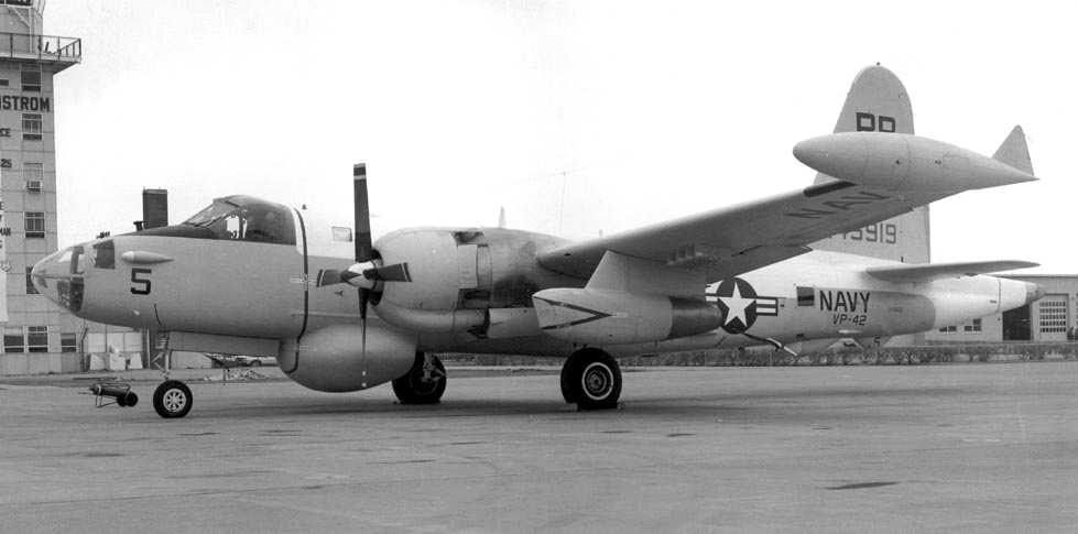
A 1969 photo of a Navy SP-2H Neptune patrol plane in front of Malmstrom's tower.
The February 1971 Butte Sectional Chart depicted Malmstrom AFB as having 3 paved runways, with the longest being 11,500'.
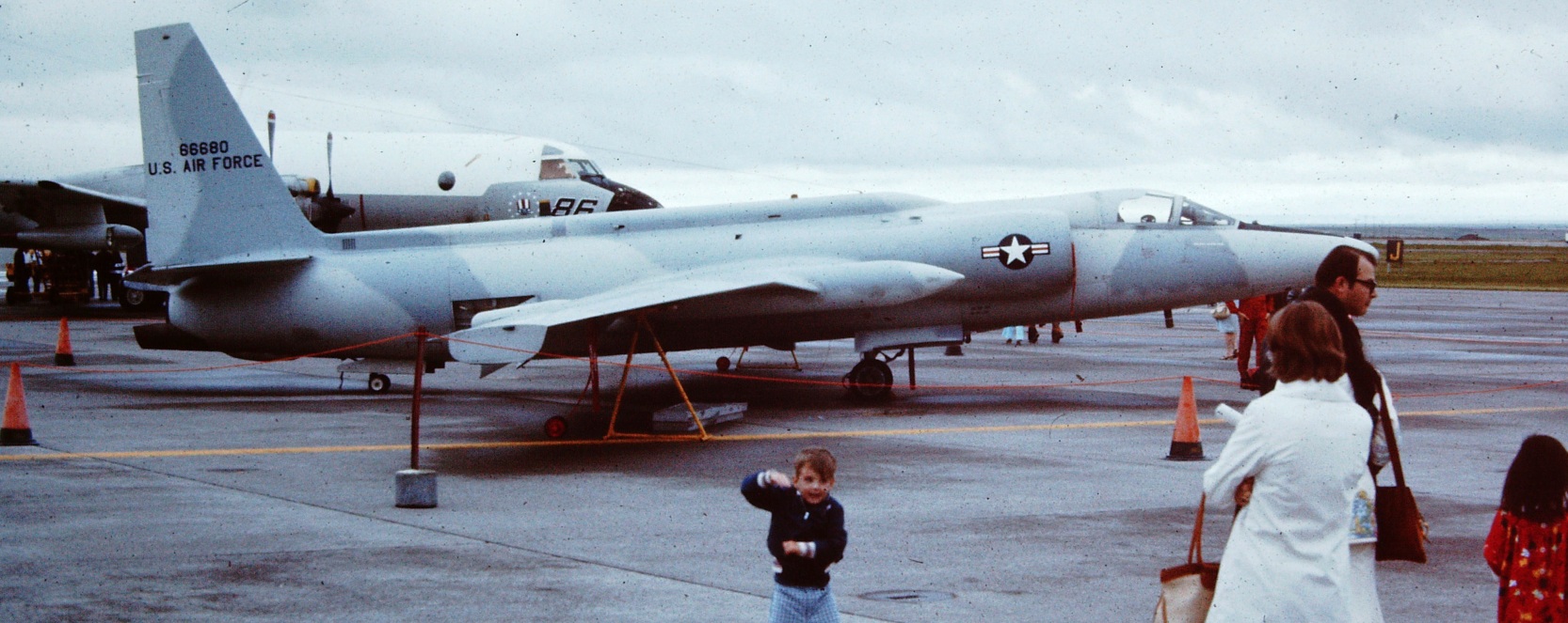
The 17th Defense Systems Evaluation Squadron, equipped with EB-57 Canberras,
was activated here in the 1970s to train NORAD air defense personnel in electronic countermeasures.
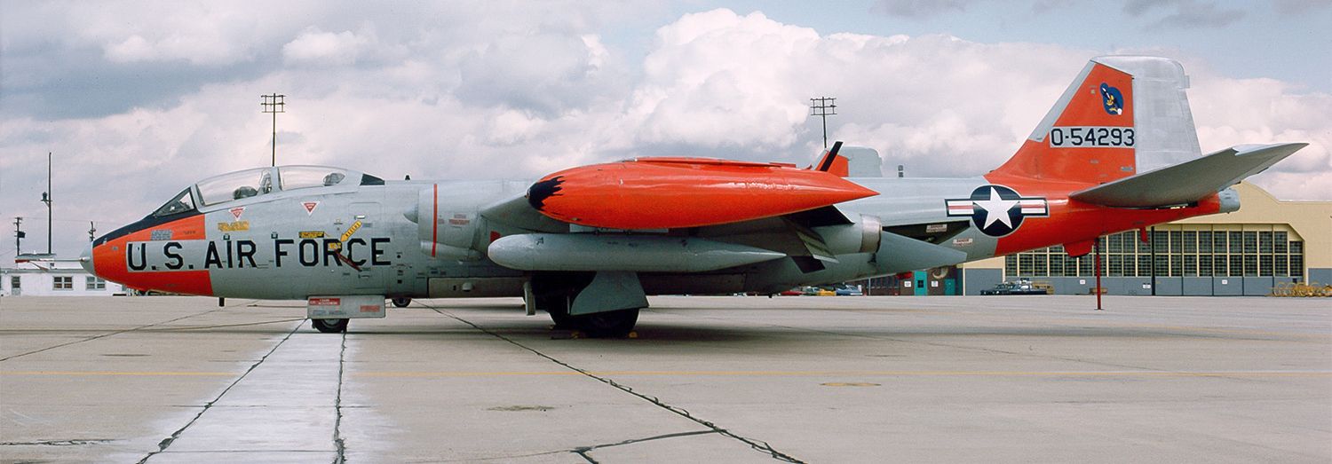
A March 1975 view of 17th DSES's Martin EB-57E Canberra 55-4293 at Malmstrom.
A 1975 view of a lineup of the 17th DSES's EB-57E Canberras at Malmstrom,
being overflown by a Navy P-3 Orion (who was apparently a long way away from any submarines).
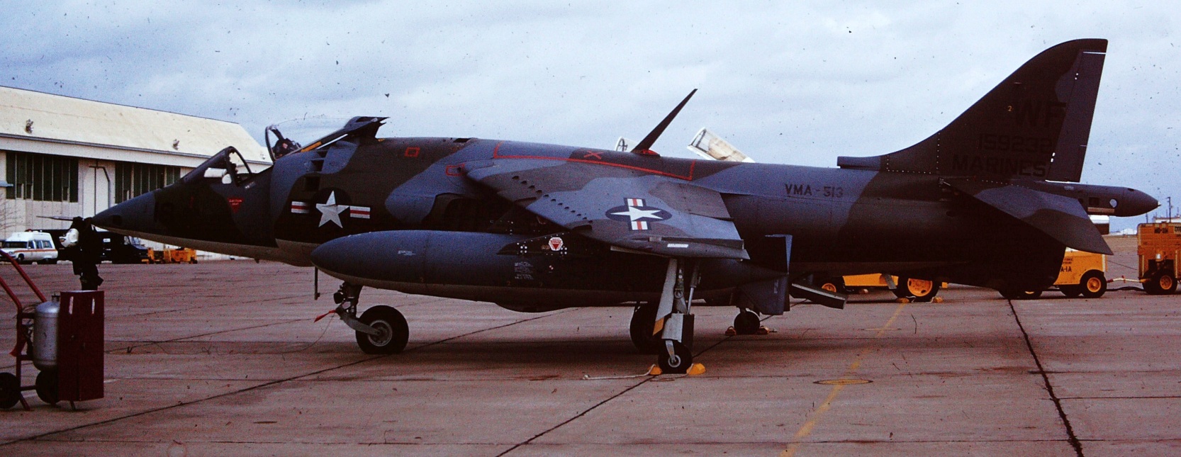
A 1976 photo of a Marine Corps AV-8A Harrier from MCAS Yuma visiting Malmstrom.
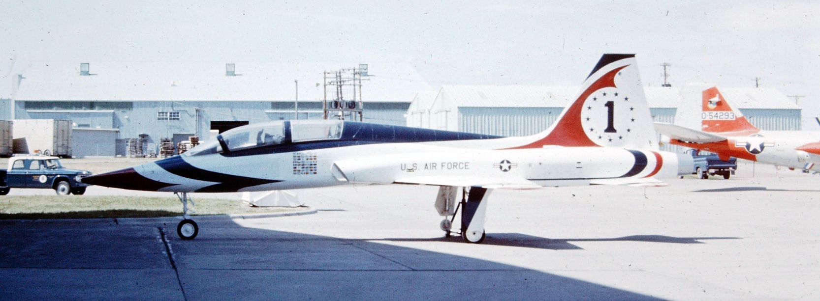
A 1976 photo of Northrop T-38 Talon Thunderbird 1 visiting Malmstrom.
A 1976 photo of a Lockheed U-2C visiting Malmstrom.
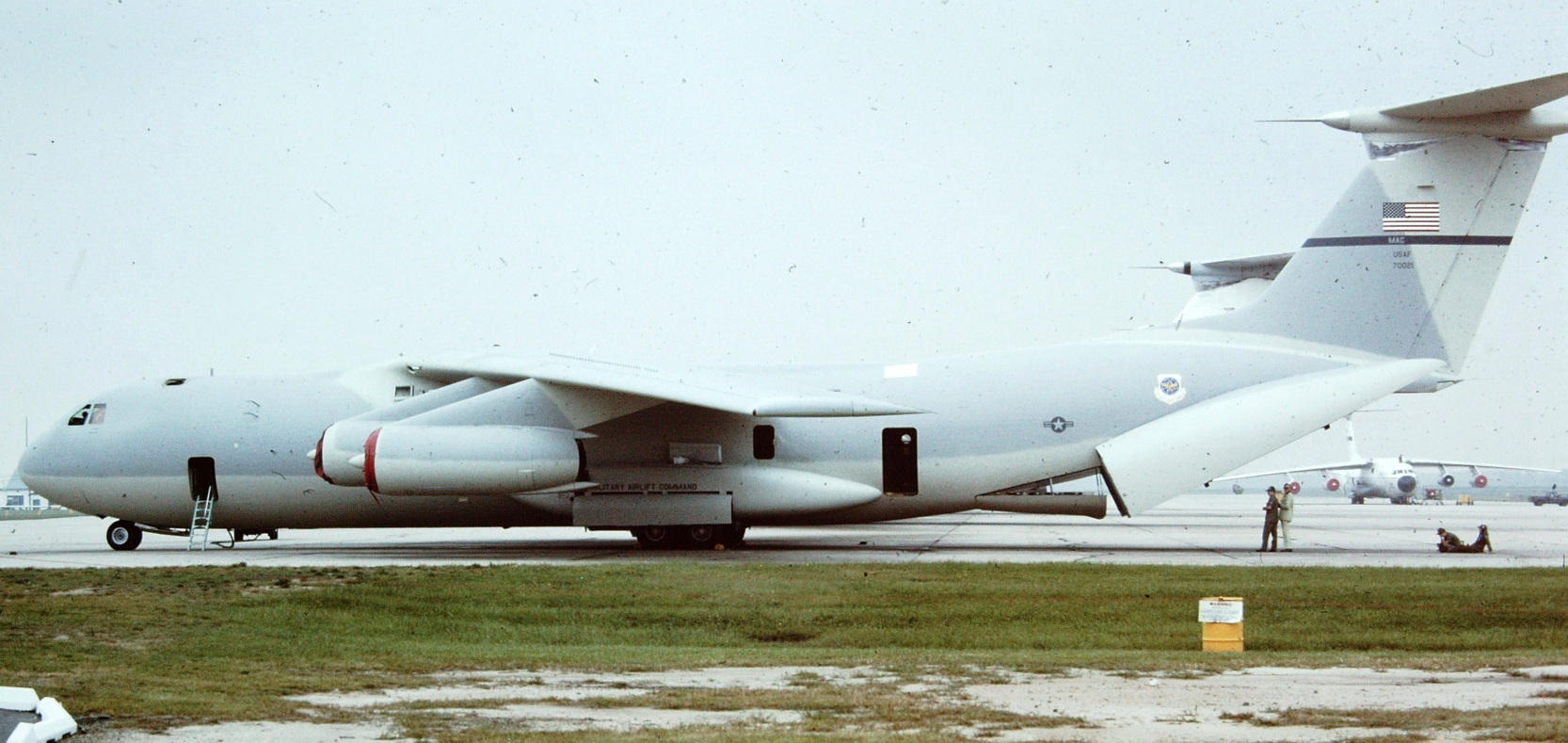
A 1977 photo of a Lockheed C-141A in an experimental tactical light-gray camouflage scheme visiting Malmstrom.
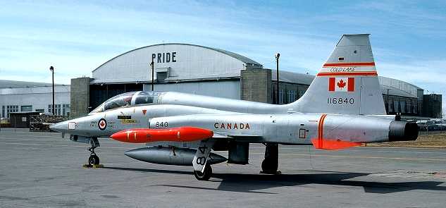
A 1979 photo of a Canadian CF-5D from Cold Lake visiting Malmstrom.
In 1988 the Hardened Mobile Launcher for the Small ICBM
was tested at Malmstrom AFB to verify its ability to operate in harsh winter conditions.
A major restructuring occurred in 1989 when SAC relocated the 40th Air Division to Malmstrom AFB
and assigned it host responsibilities for both the newly activated 301st ARW & the 341st Strategic Missile Wing.
The 301st ARW deployed to Moon Island in the Persian Gulf during Operation Desert Storm.
During this time period the 301st flew 443 Combat Sorties refueling 936 coalition aircraft,
and transferring 33.5 Million pounds of fuel.
In 1991, the 40th Air Division deactivated, returning host responsibilities back to the 341st.
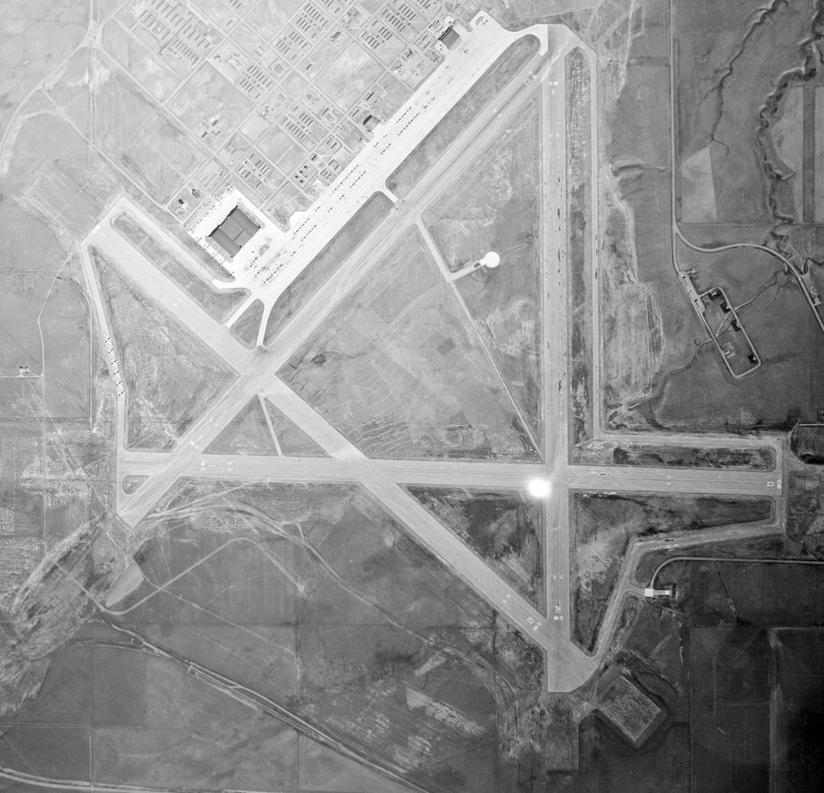
The 1991 USGS topo map depicted Malmstrom AFB as having a single runway -
the other 3 former runways were no longer depicted.
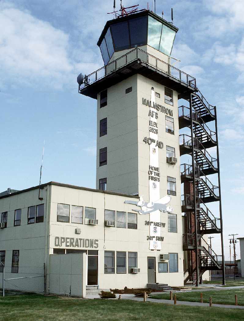
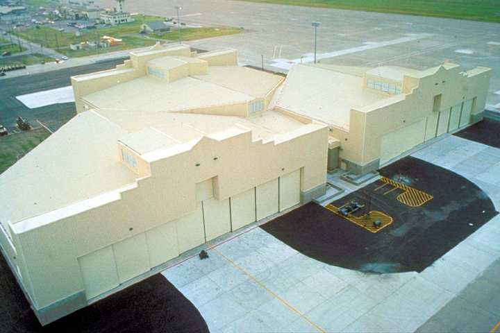
A 4/1/91 DOD photo by Russ Pollanen of Malmstrom's operations building & control tower.
Also in 1991, the Strategic Arms Reduction Treaty was officially formalized.
President Bush took all Minuteman II missiles, bombers & tankers off alert status on September 27.
As Minuteman II missiles were removed, a new program called Rivet Add was launched,
modifying the 150 Minuteman II launch facilities to accommodate the newer Minuteman III.
In the early 1990s, host responsibilities changed several times due to massive Air Force restructuring programs.
In 1992, Malmstrom's host responsibilities were again transferred, this time to the Air Mobility Command's 301st ARW.
Later that same year, the Air Force restructured its major commands,
deactivating SAC & replacing it with Air Combat Command (ACC).
WLDesign recalled, “The Malmstrom KC-135 hangar was built in either the summer of 1992 or 1993.
I was a welder & steel worker on the project.
What was sad was the waste I saw, as this was a multi-million dollar project to build maintenance hangars
for the KC-135 tankers that were moved from Malmstrom in 1995.
So much for saving money on the base realignment.”
In 1993 responsibility for Malmstrom's ICBM force was transferred to Air Force Space Command.
The last aeronautical chart depiction which has been located showing Malmstrom having an open fixed-wing runway was on the February 1994 Great Falls Sectional Chart.
It depicted Malmstrom as having an 11,500' paved runway.
The 1995 Defense Base Realignment & Closure Commission led to the deactivation
of the 43rd Air Refueling Group with its aircraft assigned to the 6th Air Base Wing at McDill AFB, Florida.
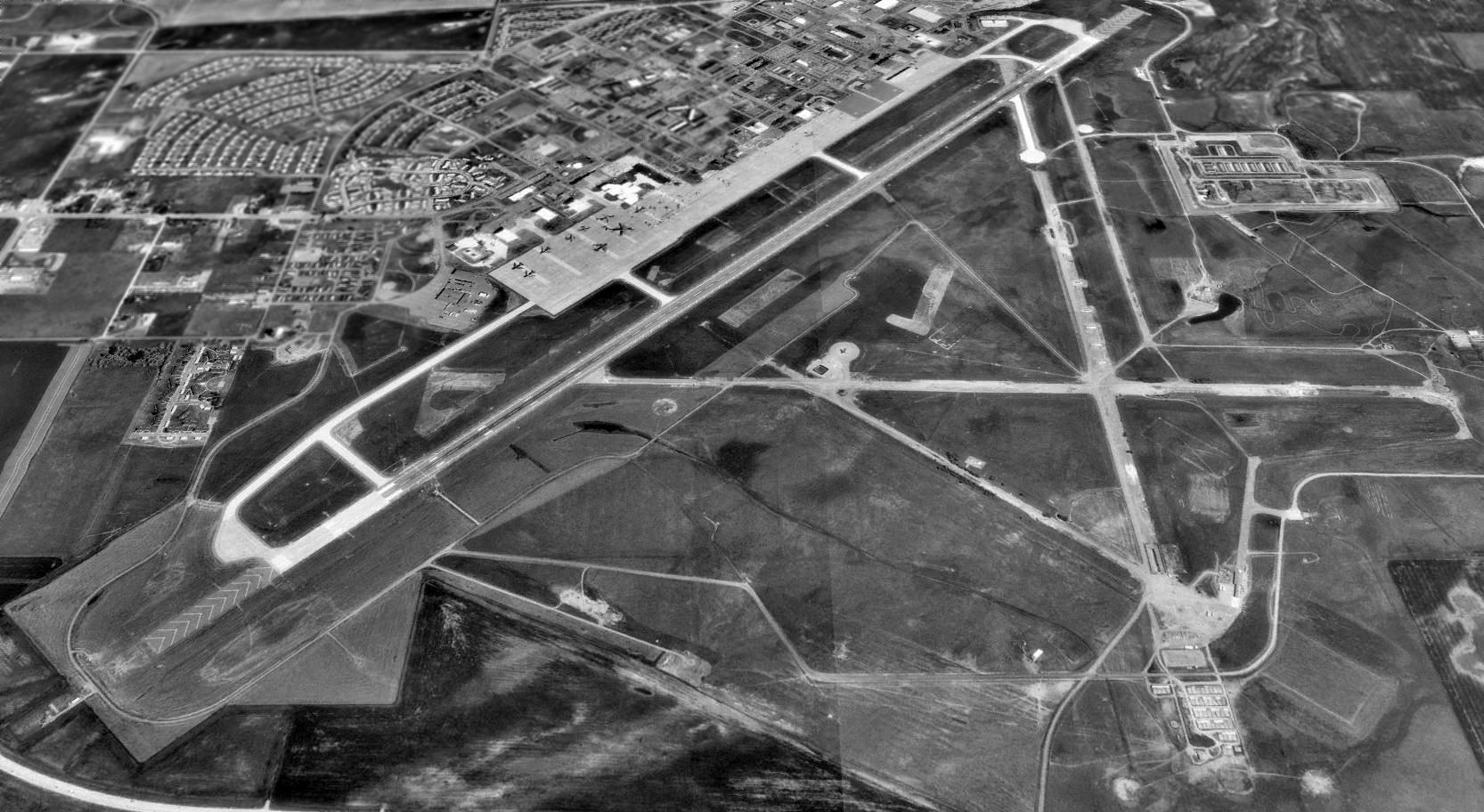
A 1995 USGS aerial view looking north at Malmstrom AFB.
In addition to the single 11,500' Runway 3/21, the remains of 3 other WW2-era runways were extant, as well.
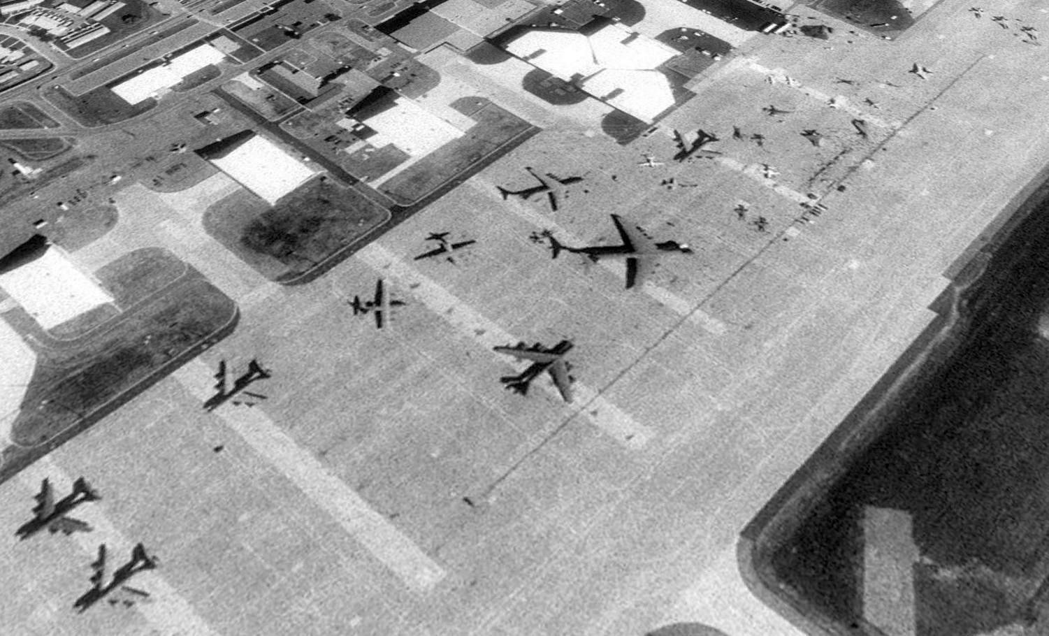
A closeup from the 1995 USGS aerial view looking north at the Malmstrom AFB ramp, apparently taken during an airshow, showing a variety of large & small military aircraft.
A circa 1990s aerial view of Malmstrom AFB hangars.
The airfield at Malmstrom was an active military flightline with numerous landings & departures daily until the end of 1996.
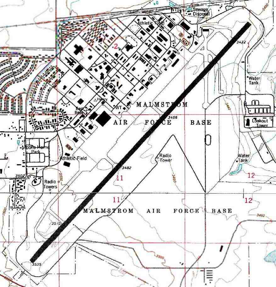
During its final years, the airfield at Malmstrom was considered an Air Force Class B airfield,
consisting of a single 11,500' x 200' Runway 3/21 with a parallel taxiway,
adjoining aircraft parking areas, and 6 interconnecting taxiways.
In 1997, Malmstrom's runway was declared inactive for the first time in the base's history.
Since closure of the airfield, the USAF has no plans or budget to operate the runway.
The July 1999 Great Falls Sectional Chart no longer depicted Malmstrom's massive runway, but instead only depicted the Malmstrom Air Force Heliport.
As of 2002, the only remaining aviation facility at this huge airfield is the Malmstrom AFB Heliport.
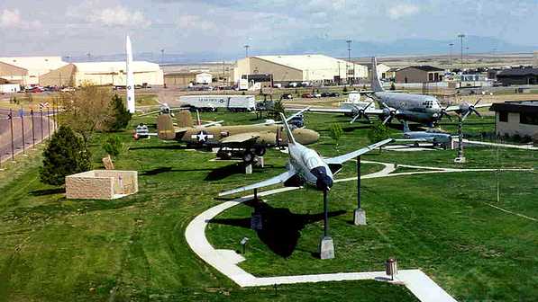
A 2/4/07 photo of the aircraft on static display at Malmstrom's museum, including an F-101 Voodoo, B-25 Mitchel, C-97, and T-33.
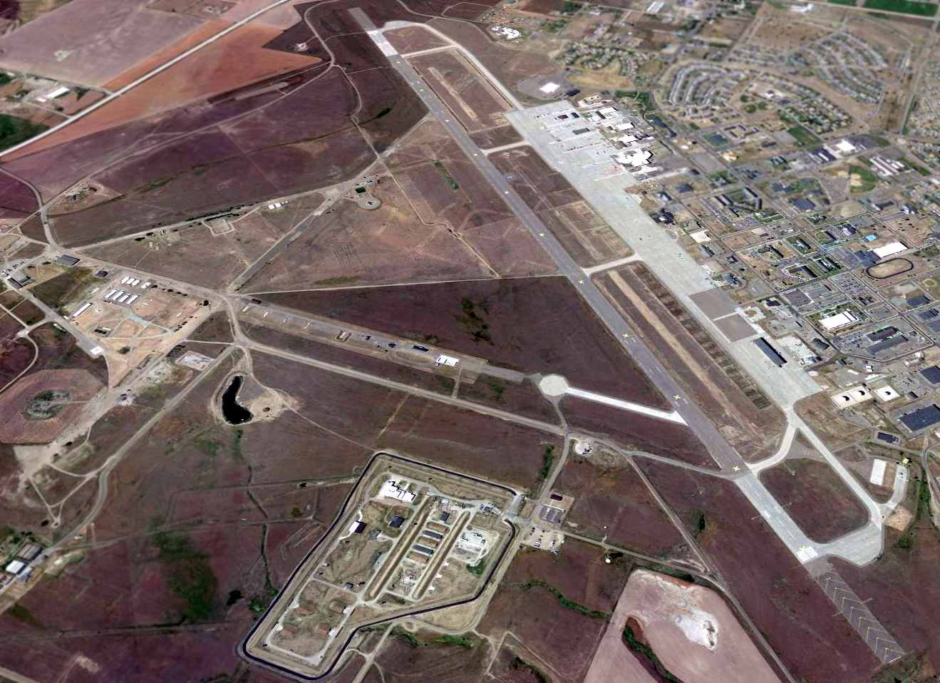
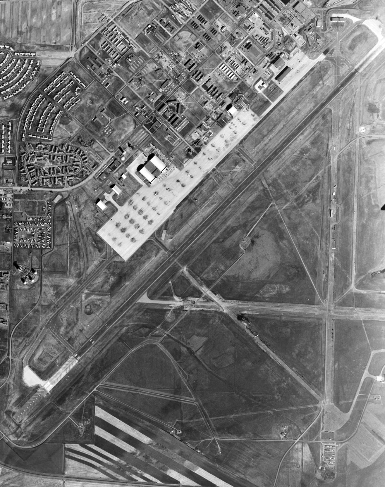
A 2014 aerial view looking southwest at the massive closed Malmstrom airfield.
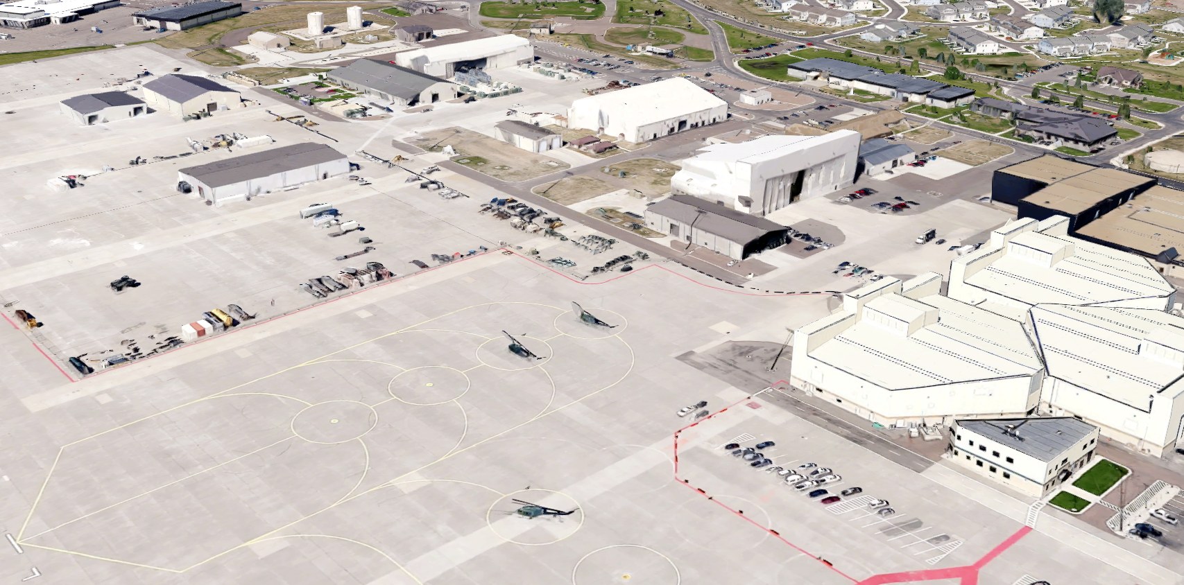
A 2022 3D aerial image looking west at the Malmstrom ramp, showing 3 UH-1N helicopters as the only remaining aircraft.
As of 2022, although its airfield is closed, Malmstrom continues to operate as an active Air Force Base,
in support of the Minuteman missiles which are deployed in the surrounding area.
See also:
http://www.malmstrom.af.mil/history.html
http://www.globalsecurity.org/wmd/facility/malmstrom.htm
____________________________________________________
Or if you prefer to contact me directly concerning a contribution (for a mailing address to send a check),
please contact me at: paulandterryfreeman@gmail.com
If you enjoy this web site, please support it with a financial contribution.
____________________________________________________
This site covers airfields in all 50 states.