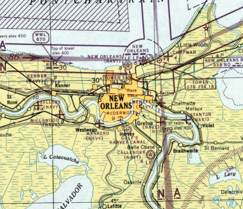
“weAbandoned & Little-Known Airfields:
Louisiana: Eastern New Orleans area
© 2002, © 2025 by Paul Freeman. Revised 10/31/25.
This site covers airfields in all 50 states: Click here for the site's main menu.
____________________________________________________
Please consider a financial contribution to support the continued growth & operation of this site.
Micheaud Factory Airfield (revised 1/26/25) - (Original) New Orleans NAS (revised 10/31/25)
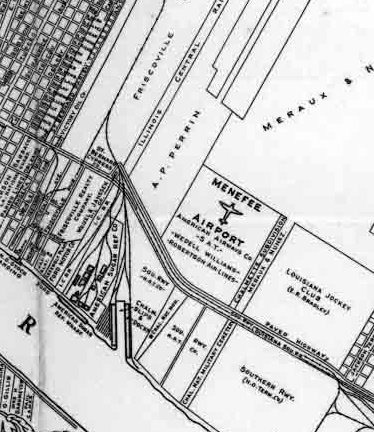
Menefee Airport / NOLF 12509 / Meraux-Neunez Airpark (revised 2/15/26) - Wedell-Williams Landing Field / Alvin Callender Municipal / Alvin Callender NOLF (revised 2/15/26)
____________________________________________________
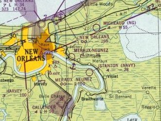
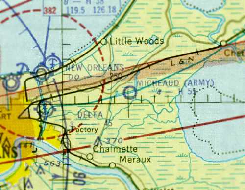
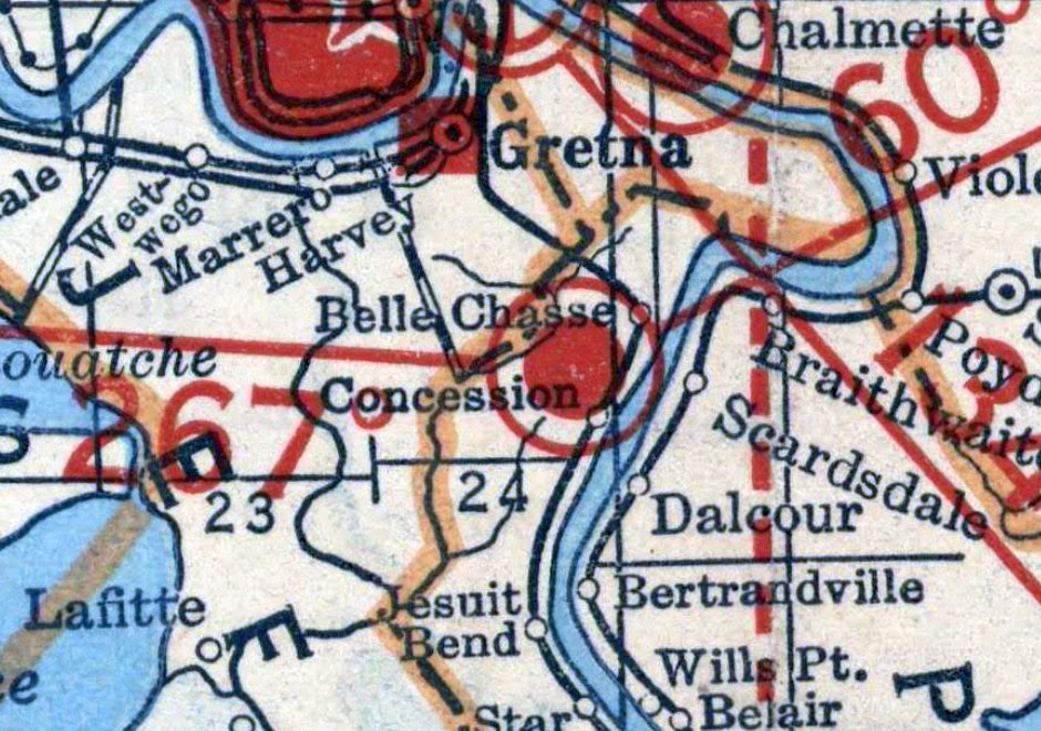
Menefee Airport / Navy Outlying Field 12509 / Meraux-Neunez Airpark, Chalmette, LA
29.95, -89.989 (East of New Orleans, LA)
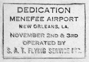
A postmark commemorating the 11/2/29 Menefee Airport Dedication (courtesy of Jonathan Westerling).
Jonathan Westerling reported, “It was not until the 1930s were well underway that the city of New Orleans was able to approve & construct a new municipal airport.
Before that, a pair of small, privately-owned airfields served the city. All commercial flights and airlines were based at these two airfields.
One of these was called Menefee Airport just east of downtown along the Mississippi River.”
According to an article in the Journal of the Louisiana Historical Association, "In addition to these entrepreneurial ventures,
J[ames]. C. Menefee, a New Orleans businessman & Chevrolet dealer, formed Menefee Airways during the spring of 1928.
Menefee leased 40 acres on the Jefferson Highway for a landing strip, purchased 2 Lincoln-Page planes,
and planned to bid on an airmail route from New Orleans to Laredo, TX, an important link on a proposed route to Mexico City.
Menefee's lead pilot, general manager, and plane builder was James Wedell,
a colorful individual who soon played a crucial role in the development of aviation in South Louisiana during the late 1920s & early 1930s."
An article in the August 1928 AeroDigest magazine is the first to describe the new field:
"The formal opening of the Menefee Airport was celebrated by an elaborate air fete attended by some 10,000 people.
The new port gives New Orleans a flying field within a few minutes ride from the heart of city & its opening was featured by airplane maneuvers, stunt flying & safety demonstrations."
According to the 4/7/29 New York Times, “Construction & improvements at the Menefee Airport in St. Bernard Parish, just below New Orleans,
are now under way & will involve the expenditure of $100,000, according to announcement of J.C. Menefee, President of Menefee Airways, Inc."
However, just two months later, a headline in the 6/15/29 journal Air Transportation announced that the airfield & its facilities had been sold to the newly formed Southern Air Transport in Dallas, TX.
Jonathan Westerling reported, “A [re-]dedication of the airfield occurred 11/2/29 according to envelopes sent that day, which were emblazoned with a cancellation commemorating the event.
Note that Southern Air Transport would become American Airlines a few years later.”
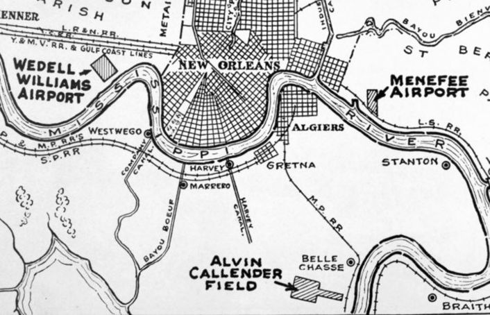
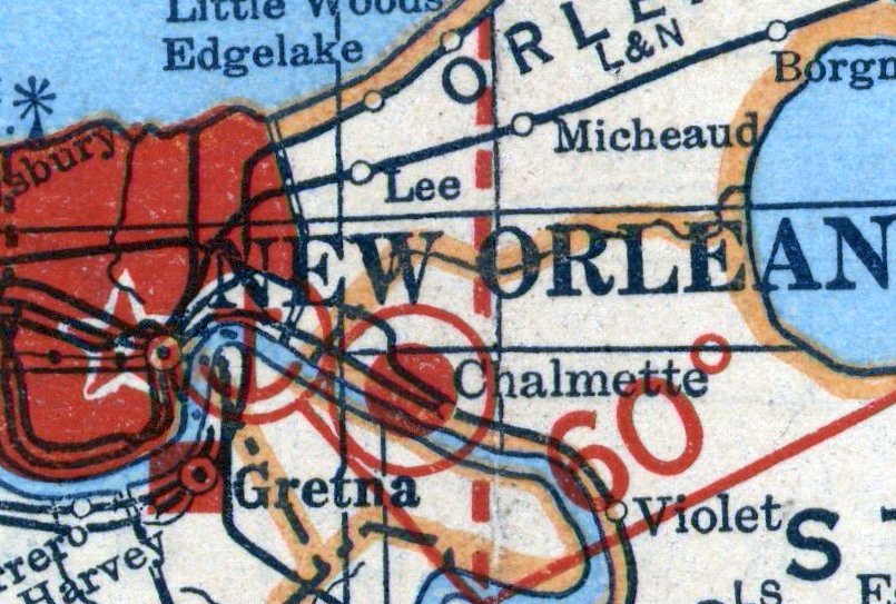
Menefee Airport, as depicted on a 1929 New Orleans Association of Commerce map.
According to Neworleanshistorical.org, when the airport was sold, Menefee Airline's fleet of planes was transferred to the Wedell-Williams Air Service
but continued to be based at Menefee Airfield while the new Wedell-Williams Airport (profiled elsewhere on this site) was under construction in Jefferson Parish to the west of the city.
The air service continued to provide passenger service from Menefee Airport until the new airport was completed in 1931.
The earliest depiction which has been located of Menefee Airport was in the 12/16/29 Commerce Department Airway Bulletin (courtesy of Jonathan Westerling).
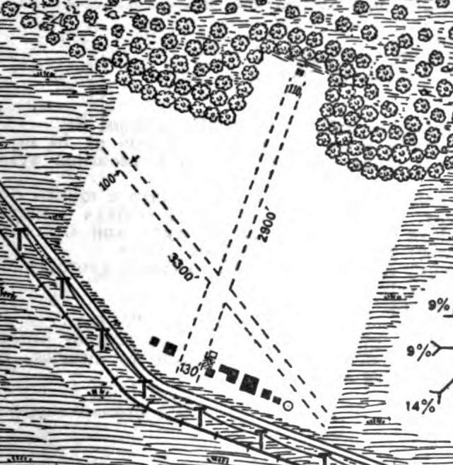
The 12/16/29 Commerce Department Airway Bulletin (courtesy of Jonathan Westerling) described Menefee Airport
as having 2 white shell surface runways, measuring 3,300' northeast/southwest & 2,900' northeast/southwest.
Eight buildings were depicted along the south side.
Menefee Airpport, as depicted on the 1929 Air Trails Map (courtesy of Jonathan Westerling).
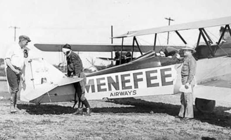
A circa 1920s photo of a Menefee Airways biplane (model undetermined) (courtesy of the Louisiana State Department of Culture Recreations & Tourism).
According to the Autumn 1988 Journal of the Louisiana Historical Association, better lighting & radio facilities were installed at Menefee Airport in 1931:
“Because of the presence of American Airways, intermediate landing fields were improved,
the latest design of lights were installed at Menefee field & a 2-way radio telephone system was set up between the airport & all American Airways ships in the field."
Menefee Airpport was depicted as a rectangular property outline on a 1931 map (courtesy of Jonathan Westerling).
The earliest photo which has been located of Menefee Airport was a September 1933 aerial view (courtesy of the LSU Cartographic Information Center, used with permission).
It showed the field to have 2 shelled runways, with 1 plane parked near the hangars on the south side, one of which had large “American Airways” lettering on its roof.
Menefee Airport was profiled in the 1934 Airway Bulletin #2 as having 2 shell runways, measuring 3,300' northwest/southeast & 2,000' north/south.
Between 1935-45, Menefee Airport was not listed in multiple airport directories (according to Jonathan Westerling), and was not depicted on the 1936 or 1939 New Orleans Sectional Charts.
Therefore it was presumed to have been closed during this time, most likely due to the Great Depression.
At some point between 1939-43, Menefee Airport was evidently reused as a Navy Outlying Field.
The designation NOLF 12509 indicated its radial & distance from its parent training airfield.
A 5/25/43 aerial view looking northwest at “12509 Menefee Outlying Field” from the 1945 Army Airfield Directory (courtesy of Scott Murdoch)
depicted Menefee as having 2 runways, along with an added landing mat (also shell surfaced) in the middle of the runways.
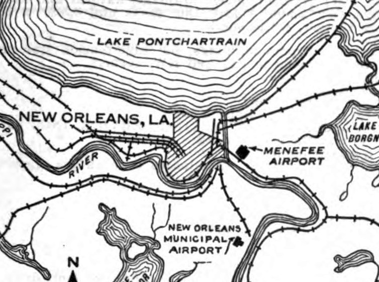
The earliest aeronautical chart depiction which has been located of Menefee Airport was on the 1944 Sectional Chart (courtesy of Jonathan Westerling).
It depicted NOLF “12509” as an auxiliary airfield.
The 1945 Army Airfield Directory (courtesy of Scott Murdoch) described “12509 Menefee Outlying Field”
as a 180 acre property, owned by private interests & operated by the Navy.
It described Menefee as having 2 sod runways, along with a 1,500' x 1,500' shell landing mat (with the note to “Use mat only.”).
The 1946 Sectional Chart (courtesy of Jonathan Westerling) once again depicted Menefee as a public-use airport.
The 1946 Airman's Guide listed Menefee Airport as again being a public airport & having a 3,100' runway.
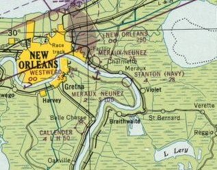
The 1947 Sectional Chart (courtesy of Jonathan Westerling) showed the airfield had been renamed to Meraux-Neunez Airpark, with a 2,500' unpaved runway.
The August 1947 Airman's Guide described Meraux-Neunez Airpark as having a 2,500' runway and fuel, storage, major aircraft, and major engine repairs.
The last aeronautical chart depiction which has been located of Meraux-Neunez Airpark was on the 1949 Sectional Chart (courtesy of Jonathan Westerling).
The June 1949 Airman's Guide indicated that Meraux-Neunez Airpark had been Abandoned.
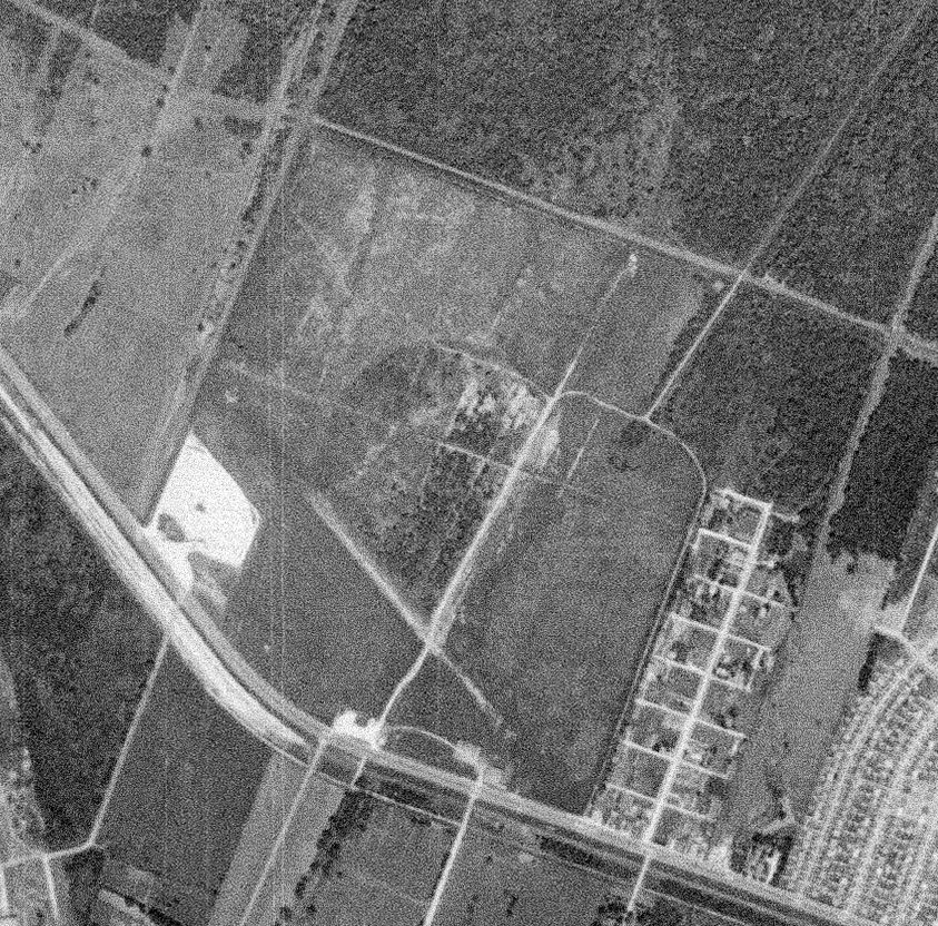
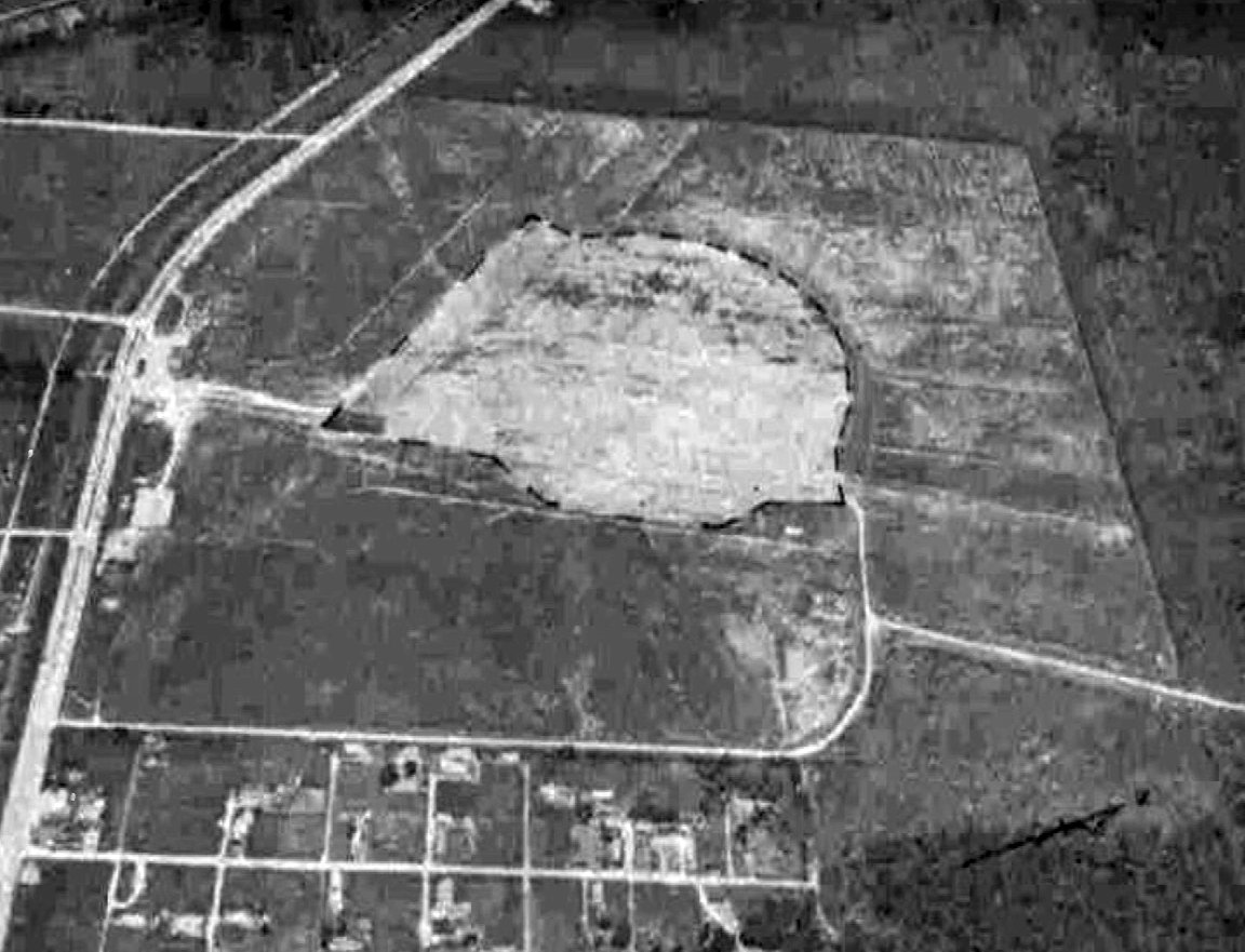
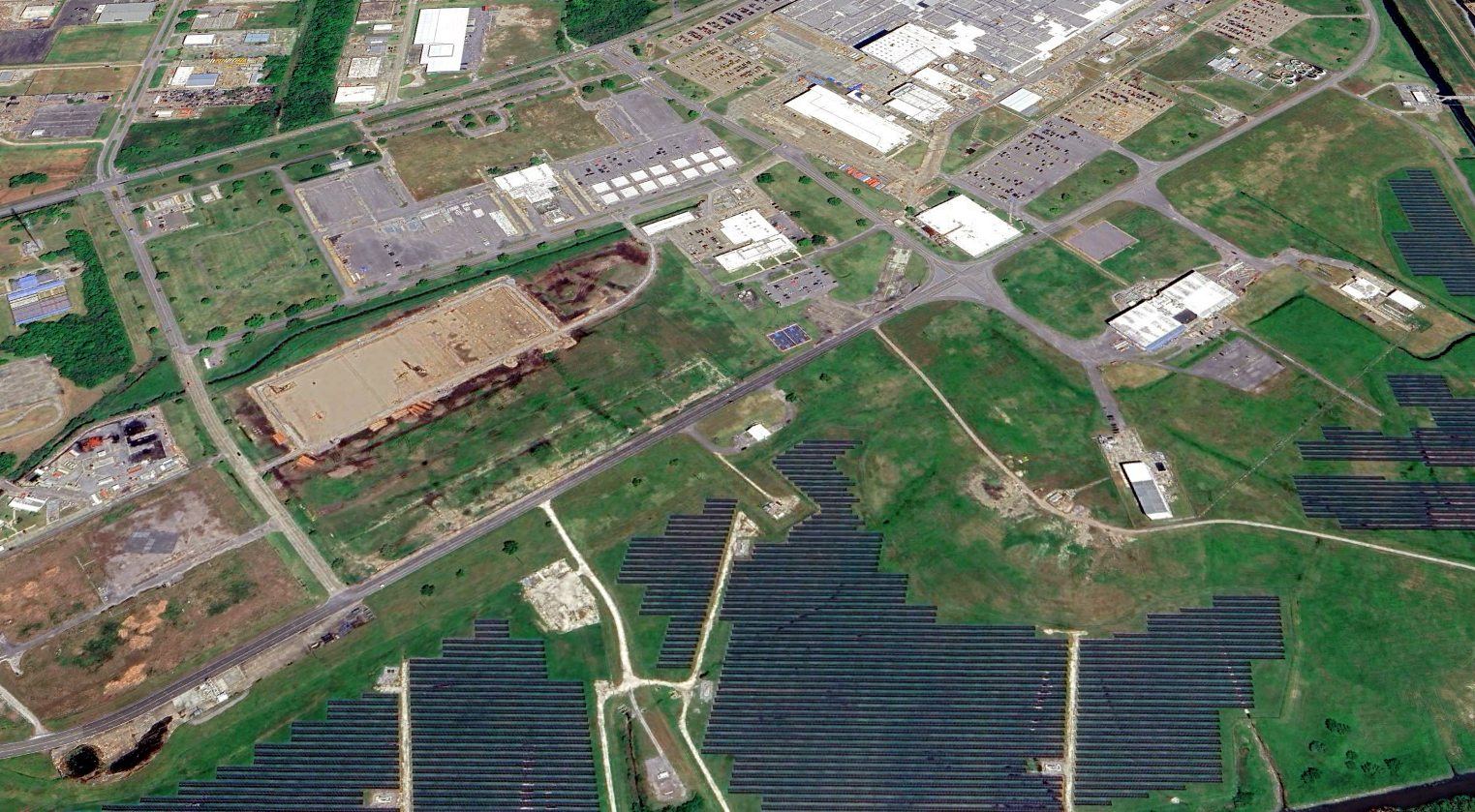
A 1952 aerial photo showed the Menefee Airport site appeared abandoned but largely intact, including the runways & hangars.
A 1965 aerial photo showed that the western half of the Menefee Airport site was still clear,
with trace of the northwest/southeast runway still recognizable, along with the landing mat.
Streets had been built for housing on the eastern half.
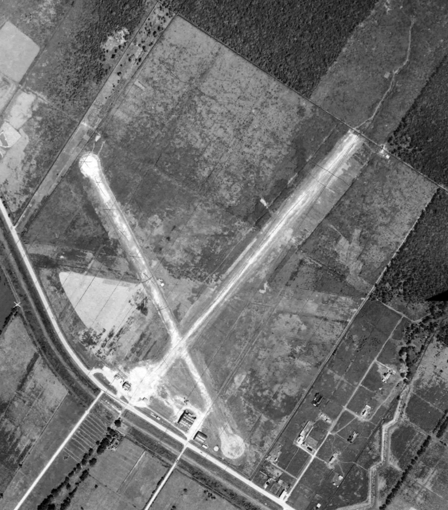
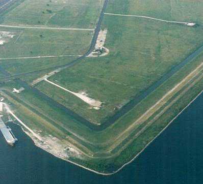
Amazingly, a 2002 aerial photo still showed recognizable traces of Menefee Airport's northwest/southeast runway & landing mat.
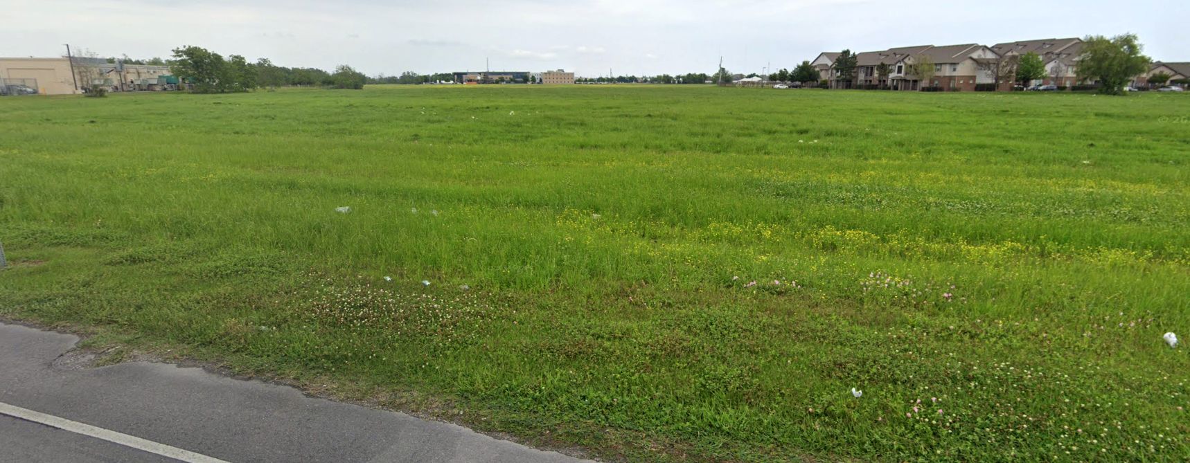
A 2023 photo looking north at the Menefee Airport site, most of which remains an open grass field.
A 2023 aerial view by Jonathan Westerling looking northeast at the site of Menefee Airport, showing that the western half remains largely clear, in an otherwise densely developed area.
Jonathan noted, “I took the 2023 aerial photo of the Menefee Airport location while sitting on an American Airlines jet which is a nice tie-in given this is an airfield where American flew from 90 years ago.”
Thanks to Jonathan Westerling for pointing out this airfield.
____________________________________________________
Micheaud Factory Airfield, New Orleans, LA
30.03, -89.92 (East of Downtown New Orleans, LA)
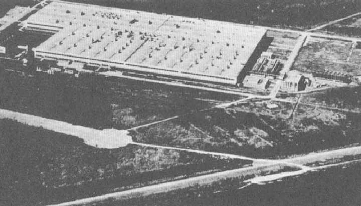
A circa 1940s aerial view looking southwest at the Michoud factory airfield, with the factory in the foreground (courtesy of Carl Hennigan).
In 1942, the New Orleans Higgins Shipbuilding company received a contract to build 200 Liberty Ships -
the largest shipbuilding contract awarded up to that time.
Higgins chose the old Micheaud (Michoud) plantation site on the Intracoastal Canal 10 miles east of downtown New Orleans
for the construction of his revolutionary assembly line shipyard.
Higgins claimed the Michoud Shipyard would turn out 24 ships per month - half of the total national output.
Within 3 short months the entire facility was half completed.
Apparently, the immense amounts of money and human effort poured into the grand project
was of no concern to the Maritime Commission which suddenly & unexpectedly canceled the project
citing a shortage of steel as the reason.
President Roosevelt toured Higgins Industries' City Park Plant in late September, 1942.
After observing Higgins' assembly lines work at full speed turning out motor torpedo boats, antisubmarine boats, and landing craft,
he and Higgins discussed producing wooden cargo planes or "flying boats" at Michoud.
By October 29, Higgins & the War Production Board had concluded preliminary contract negotiations
to build C-76 Curtis Caravans, a molded plywood aircraft partially based
on the metal C-46 Commando cargo plane, for the Army Air Force.
On October 30, the national press reported the imminent award of a 1,200 plane contract.
Shooting for a 6-month initial production date, Higgins requested a halt
to the demolition of a $1,000,000 steel loft at Michoud needed to house Caravan production.
FDR told reporters he had earlier instructed the WPB, the Maritime Commission,
and the Army and Navy to find some defense use for Michoud.
On 11/6/42 the Army Air Corporation approved a letter of intent for a 1,200 plane contract.
$30 million dollars of the $180 million contract was earmarked for the completion of Michoud's construction & tooling.
But reliance on defense production again proved hazardous.
In August, 1943 the War Department, citing increased aluminum production,
canceled contracts for the more expensive, less efficient, wood-alloy C-76 Curriss Caravan.
Nothing was depicted at the site of the Higgins plant on the 1943 USGS topo map.
The Higgins plant had the USAAF code of “HI” during WW2.
But Higgins still claimed a right to build the metal C-46 Commando.
Higgins proceeded to tool-up for its production along with outer wing panels for the C-46 production at Curtiss-Wright.
In early October his Michoud plant had already begun constructing sub-assembly parts for Curtiss-Wright.
The Michoud Aircraft Plant was officially dedicated on 10/24/43.
The public gathered in the huge 43 acre main assembly building - second only in floor-space to Ford's Willow Run plant.
But the War Department soon shifted its emphasis in the air war requiring more bombers & larger, long-range troop transports.
Higgins' contract for 500 C-46 cargo planes was canceled in August, 1944.
The grand hopes for Michoud & the aircraft industry in New Orleans were dashed.
The net result: only 2 C-46 cargo planes were ever produced by Higgins Aircraft
and the Michoud facility joined the ranks of other "boom or bust" industrial plants.
No airfield at this location was depicted on the July 1945 or August 1948 Mobile Sectional Charts.
The earliest dated depiction of the Michoud Airfield which has been located was on the February 1949 Mobile Sectional Chart.
It described the “Micheaud (NG)” [National Guard] airfield as having a 5,500' paved runway.
During the Korean conflict (circa 1950-53) the Michoud facility was again activated
for the production of 12-cylinder air-cooled engines for Sherman & Patton tanks.
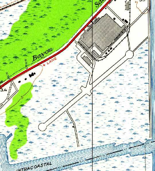
The earliest topo map depiction which has been located of the Michoud factory airfield was on the 1951 USGS topo map.
It depicted a single paved northeast/southwest 5,500' runway with turn-arounds at both ends, and a taxiway leading to the factory.
Neither the airfield nor the factory was labeled.
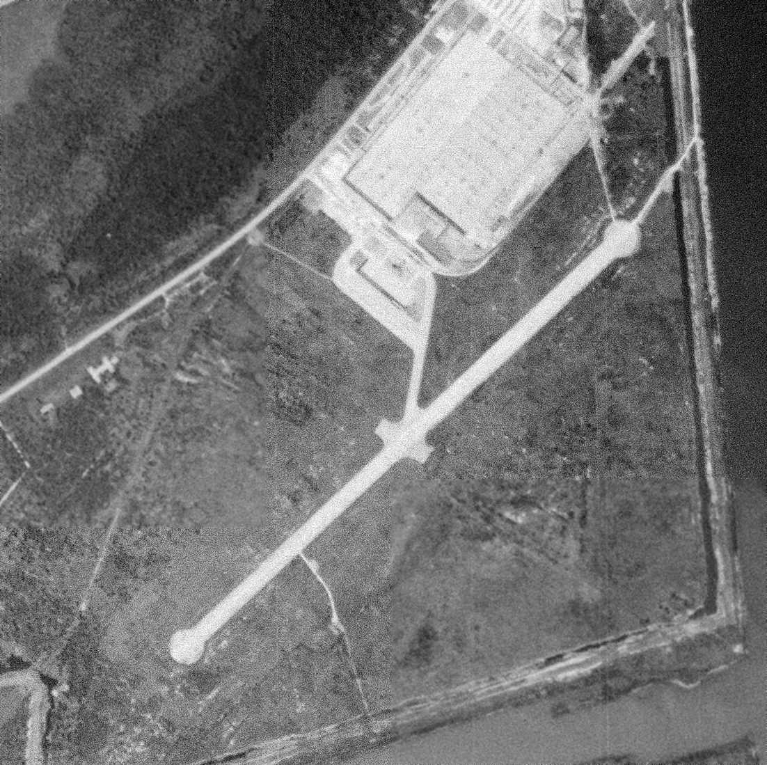
The last photo which has been located showing the entire Michoud factory airfield runway remaining intact was a 1952 USGS aerial view.
It depicted a single paved northeast/southwest runway, with a paved taxiway leading to a ramp adjacent to the factory.
The last aeronautical chart depiction which has been located of the Micheaud airfield
was on the 1952 New Orleans Sectional Chart (courtesy of David Brooks).
The Aerodromes table on the chart described “Micheaud (Army)” airfield as having a single 5,500' hard-surface runway.
But the remarks said the field was “Inactive”, with “No facilities”.
The last directory reference which has been located to Micheaud Field
was its listing in the 1953 Aviation Week Airport Directory (courtesy of David Brooks).
It described “Micheaud Field” as “military, inactive – no facilities.”
A circa 1950s aerial view looking west showed the northern end of the Michoud runway with the factory behind it.
By the time of the February 1953 Mobile Sectional Chart, the Michoud airfield was no longer depicted at all.
In 1961, with the space race with the Russians heating up,
the National Aeronautics & Space Administration took over the facility for design & assembly of large space vehicles.
The first space project at the Michoud facility was the design & development of the first stage of the powerful Saturn booster,
destined to place man on the moon.
The 1962 USGS topo map continued to depict the airfield in the same fashion as on the 1951 topo map.
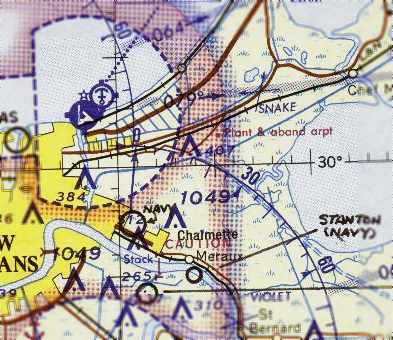
The 1965 New Orleans Sectional Chart (courtesy of John Voss) labeled the site as “Plant & abandoned airport”.
The 1968 USGS topo map labeled the site as “National Aeronautics & Space Administration”,
and showed that a road labeled “Saturn Boulevard” had covered the alignment of the former runway.
A more minor aviation use persisted though, as a Heliport was depicted north of the former runway midpoint.
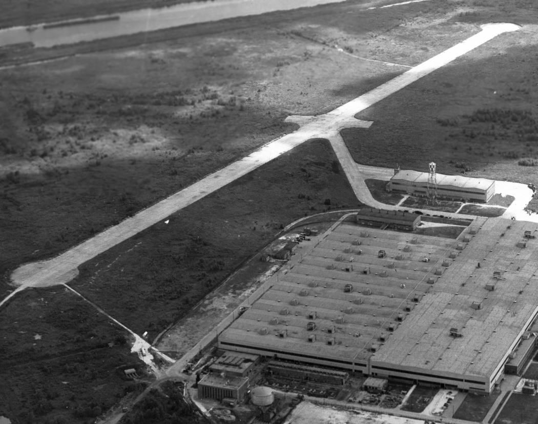
A 1968 NASA aerial photo looking southeast at the Michoud Assembly Facility,
with the former airfield area right behind the building.
Construction of the Saturn S1B and S1C boosters continued at the Michoud facility until the early 1970s,
when the Apollo program wound down & work began on the Space Shuttle, the next generation launch vehicle.
In a 1976 aerial photo (courtesy of Carl Hennigan), the former runway had been covered by a road, and was no longer recognizable as a former runway.
According to David Brooks, “I talked to a friend who worked for NASA for 35 years.
He visited the Michoud plant several times & said there was a bit of remains of the runway still there
when the NASA Saturn & latter Shuttle external tank projects were there.
NASA used part of the [former] runway for lay-down storage of large items.”
Eric Rabalais recounted an episode from May 1988: “A Taca Airlines Boeing 737 [Flight 110]
deadsticked it into the grassy area on the south side of the facility, after being struck by lightning.
It was stuck in the mud, but luckily there were no injuries. The maintenance crew showed up the next day & swapped an engine out.
It later took off from the old runway & headed for Lakefront Airport. That was an exciting couple of days at work!”
A controller in the New Orleans TRACON recalled the incident: “The flight was TACA 110. The flight was originally supposed to arrive over the Leeville VORTAC
but due to thunderstorms in the metro area opted to arc south through east.
They basically came into approach airspace from due east.
As they made their descent into the New Orleans area they encountered a rapidly growing thunderstorm.
At this point they were about 10-12 nautical miles northeast of NBG (NAS New Orleans).
They reported the loss of both engines. The weather prohibited them from diverting to NBG.”
The controller continued, “The controller working the aircraft suggested Lakefront Airport. The 6,600' runway there would be suitably long enough.
We advised Lakefront to suspend any pattern operations & standby for an emergency arrival in the form of an air carrier.
TACA's glide ratio was terrible due to the weather they were flying through.
Options we discussed in the TRACON included a possible emergency landing on the I-10 (1 straight mile for every 5 miles of highway),
ditching in Lake Bourne, or ditching in Lake Ponchartrain.
Given the aircraft's position, deteriorating glide ratio, and uncertainty of landing safely on the highway,
the pilot opted for vectors to Lake Ponchartrain.
The controller issued the heading. The reported cloud ceilings at Lakefront were 1,700' overcast.
The aircraft was northwest-bound when it passed over the Industrial Canal.
At 1,600' we lost the transponder & the aircraft made a hard turn to the left.
To a man we all thought that they had stalled out & spun in. There was no ELT signal.”
The controller continued, “The 2 controllers working were relieved from position by myself & another controller.
The other fellow took the Radar positions working the east side of the approach control airspace; I took the west airspace & our then non-radar sector.
At that point we had no idea of whether the aircraft made it or not.
Coast Guard helicopters were dispatched from NBG & were en-route to the area.”
The controller continued, “But here's how we found the aircraft.
Lakefront called for an IFR release off Runway 36L. It was a King Air filed IFR for points east.
Normally the release would be runway heading and climbing to 2,000'.
I suggested we issue the departure a right turn to 90 degrees & climb only to 1,500'.
That was our Minimum Vectoring Altitude & it would most likely keep the King Air below the cloud bases.
We solicited the King Air's help, naturally they were more than happy to assist.
They were just west of the Michoud Facility when they reported the B737 intact on the ground at the plant.
To say we were greatly relieved is an understatement.”
A 1988 photo of the TACA 737 (parked on the levee at the left edge of the photo).
It had landed on the levee (the long strip of grass) just to the right of the narrow canal that runs from the top right towards the bottom of the photo).
A controller in the New Orleans TRACON recalled, “The Boeing representatives initially thought about barging the aircraft out
but the field seemed good enough to fly off of once it dried out a bit.
They replaced both engines & about 10 days later flew the aircraft over to MSY for a straight in approach to Runway 28.
TACA had only been operating this particular aircraft (on a lease from Continental Airlines) for about 3 weeks.
It had less than 90 hours total time on the plane. It was for all, intents and purposes, brand new.”
The controller continued, “After more than 2 decades of air traffic control I still say this is the most splendid piece of air traffic teamwork
and the most incredible piece of flying I've ever been witness to or heard of.
The flight crew had mere seconds to assess the situation as to whether its the lake of the field. They nailed it.”
According to John Artus, “TACA 110 was towed into the Michoud facility for repairs,
and then took off from Saturn Boulvevard (the old Michoud Field runway) to the southwest for Moisant Field for further repair work.
So, that flight may constitute the final use of the old Michoud Field runway by an aircraft.”
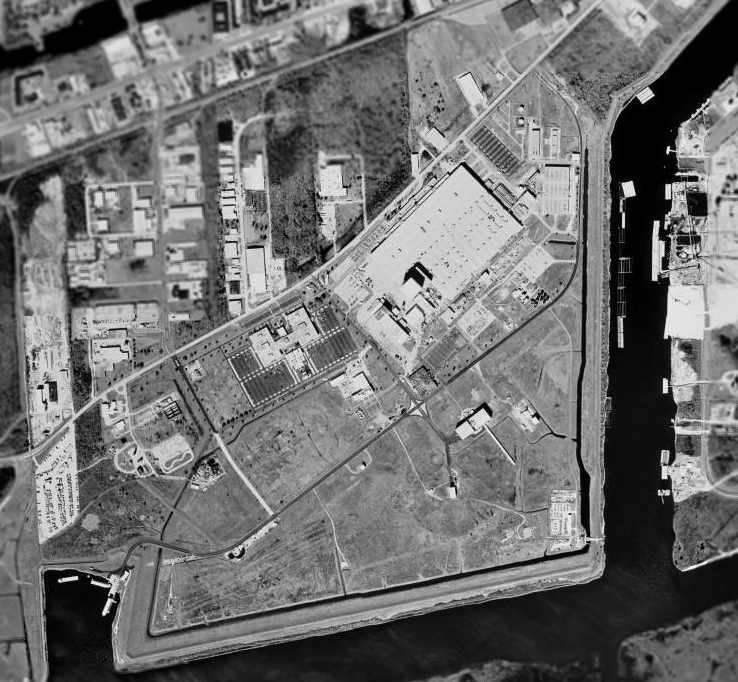
In the 1998 USGS aerial photo, the huge Michoud Assembly Facility building is just northeast of the center of the photo.
According to Eric Rabalais, “The old runway is the long road that runs from southwest to northeast.”
Note the barges at the inlet at the southwest corner, used to ferry the completed Space Shuttle External Tanks to Florida.
The industrial buildings at Michoud sustained significant damage from Hurricane Katrina in 2005.
A 2005 aerial photo looking north at the Michoud Assembly Facility, with the former airfield area in the foreground.
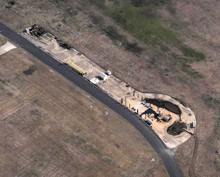
A circa 2006 aerial view looking east at a remnant of the former Michoud factory airfield -
the southwestern end of the runway pavement, complete with turnaround pad.
This segment matches the configuration & location of the runway seen in the 1952 aerial photo. Portions of a taxiway also remain.
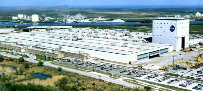
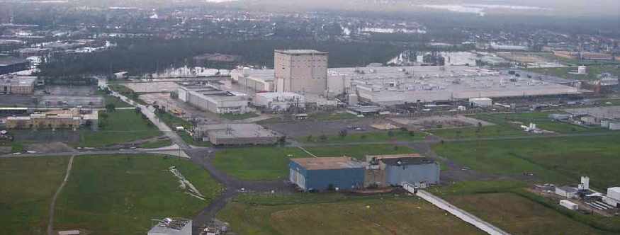
As of 2008, Lockheed Martin operates the Michoud Assembly Facility under contract to NASA, manufacturing the Space Shuttle's External Tank.
Lockheed Martin has been selected to construct the Space Shuttle's successor, the Orion Crew Exploration Vehicle.
According to Lockheed, “Large structures & composites will be built at NASA’s Michoud Assembly Facility.”
A 2023 aerial view looking north shows the southwest remains of the Michoud factory runway remains intact.
The Michoud Assembly Facilty is located south of the at the intersection of Michoud Boulevard & Old Gentilly Road.
____________________________________________________
Original New Orleans Naval Air Station, New Orleans, LA
30.03, -90.07 (West of New Orleans Lakefront Airport, LA)
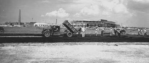
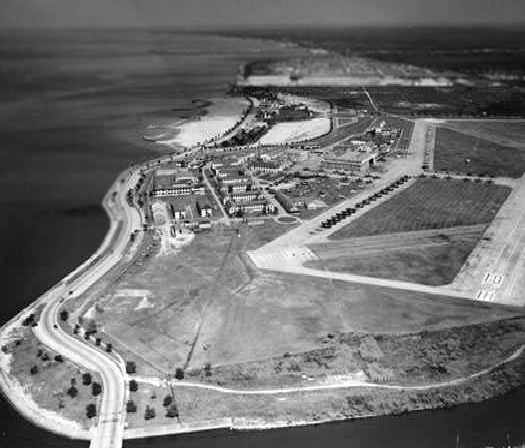
A 1941 photo (courtesy of Carl Hennigan) showing the runways being paved at the original NAS New Orleans.
Nothing was depicted at this site on the 1938 USGS topo map.
New Orleans' original Naval Air Reserve Base was commissioned in 1941,
after the city had donated 182 acres at this site along the shore of Lake Ponrchartrain.
The earliest depiction which has been located of NAS New Orleans
was a 1941 photo (courtesy of Carl Hennigan) showing the runways being paved.
The base initially conducted an Elimination Training Course.
New Orleans soon shifted to a primary flight training mission,
with over 140 aircraft, including N3N "Yellow Perils", Stearmans, and NP Startans.
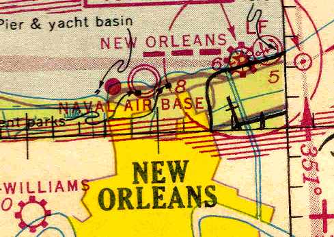
The earliest aeronautical chart depiction of the field which has been located
was on the January 1943 Beaumont Sectional Chart (courtesy of Chris Kennedy).
It labeled the field as “Naval Air Base” New Orleans.
NRB New Orleans was redesignated a Naval Air Station in 1943.
Its next mission was to conduct instructor training, using a total of over 230 aircraft.
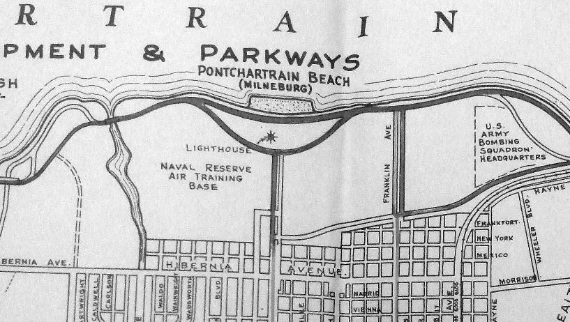
A WW2-era map depicting the “Naval Reserve Air Training Base” (from the National Archives College Park, courtesy of Ron Plante).
Also note the “U.S. Army Bombing Squadron Headquarters” depicted on a small patch of land to the east – apparently a non-flying administrative installation.
The complement of NAS New Orleans in 1944 was a total of 1,431 personnel.
Due to the short runway length, Naval Air Transport Service flights
had to use the nearby New Orleans Municipal Airport (later known as Lakefront Airport) instead.
The June 1944 New Orleans Sectional Chart (courtesy of Chris Kennedy),
depicted NAS New Orleans as having a total of 6 Outlying Fields.
A circa 1944-45 aerial view looking southeast at NAS New Orleans (courtesy of John Voss) showed a huge number of Navy aircraft on the ramp.
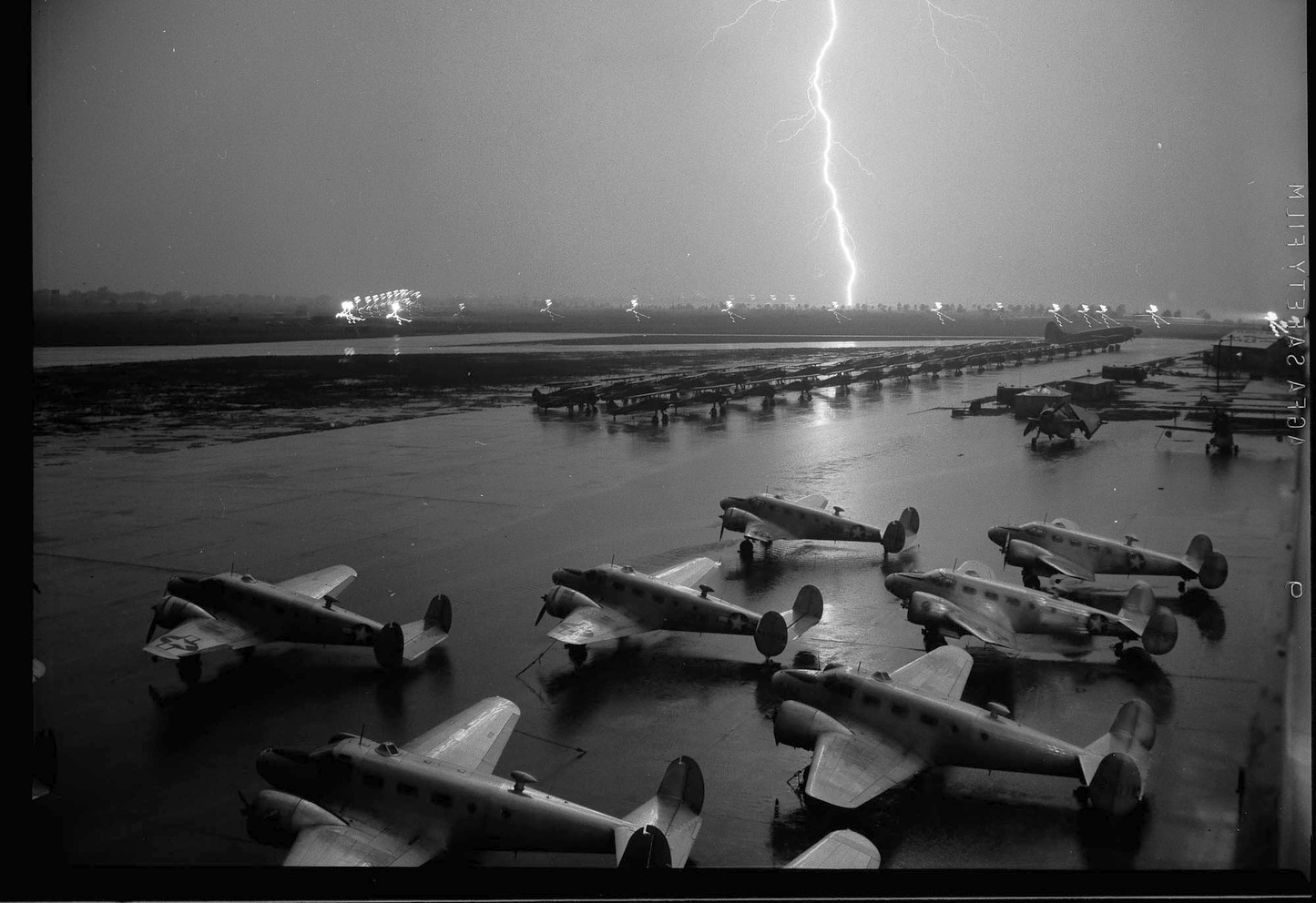
A circa 1944-45 photo showing a lightning strike at NAS New Orleans (courtesy of John Voss).
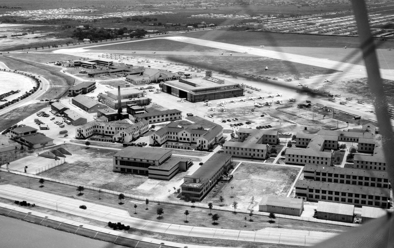
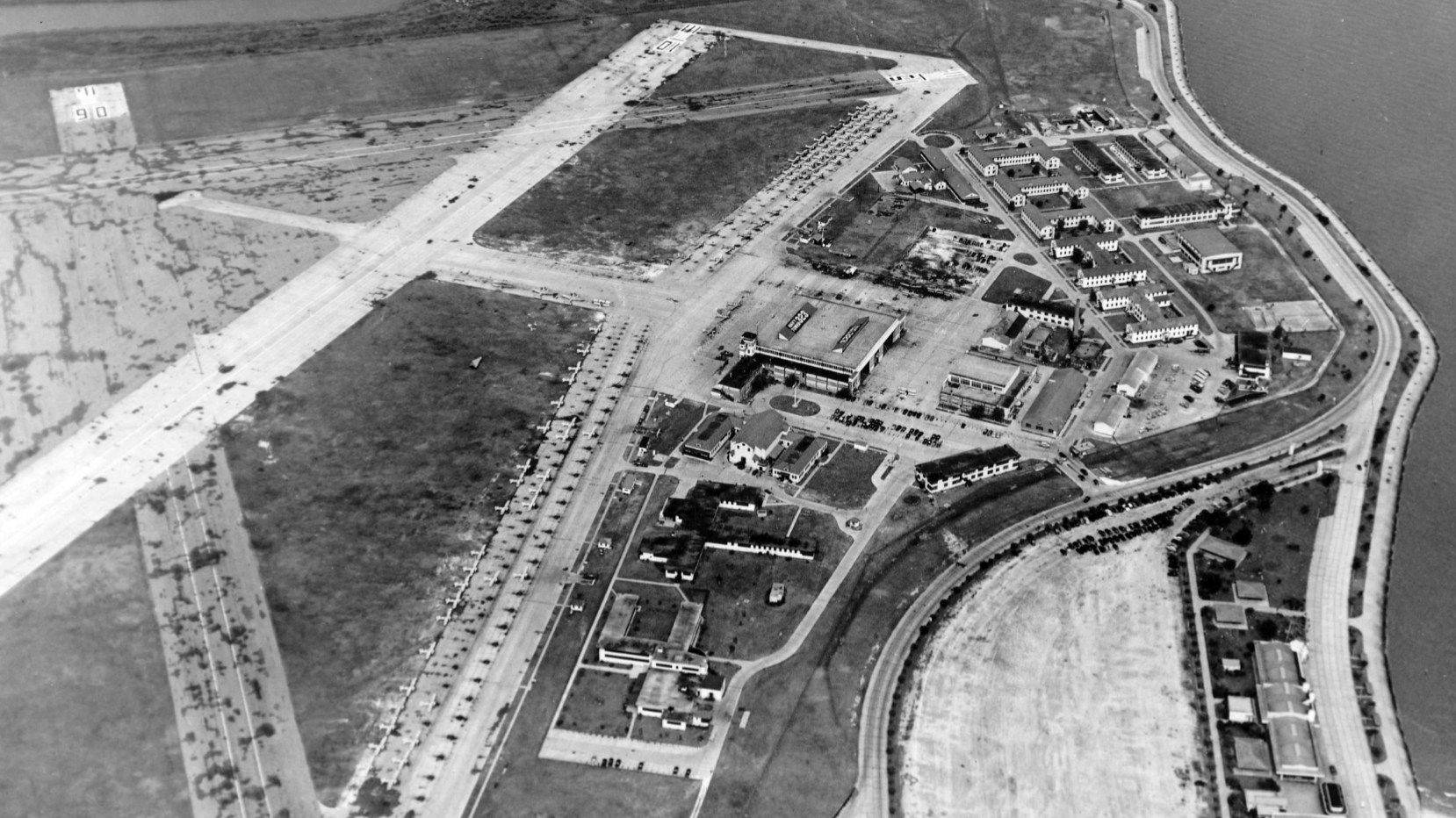
A 3/16/45 aerial view looking south at New Orleans NAS (National Archives photo).
The photo showed one 3,300' concrete runway, 2 shorter asphalt runways, taxiways, a large ramp, a single hangar, and a large number of aircraft.
By the time of the July 1945 New Orleans Sectional Chart, NAS New Orleans was depicted as having a total of 8 Outlying Fields.
Among these were Moisant Airport (later to become New Orleans International Airport), and Alvin Callender Field.
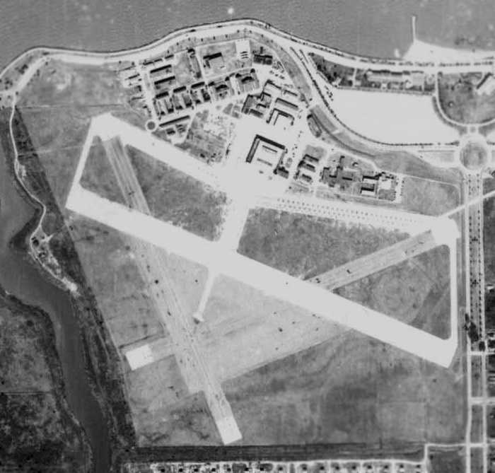
A November 1945 aerial view of NAS New Orleans (courtesy of John Anderson)
depicted the field as having a concrete southeast/northwest runway, 2 shorter asphalt runways, taxiways, a large ramp, a single hangar, and a large number of aircraft.
Following WW2, the instructor school transferred to Glenview NAS, and NAS New Orleans assumed a Naval Air Reserve mission.
A 1948 aerial view looking east (courtesy of Carl Hennigan) showed a large number of Navy aircraft visible on the ramp of the original NAS New Orleans.
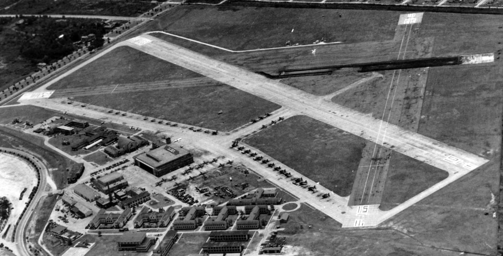
A 1948 aerial view looking south (courtesy of Gary Frey) showed a large number of Navy aircraft visible on the ramp of the original NAS New Orleans.
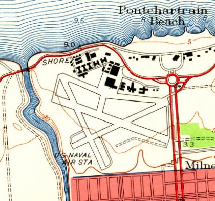
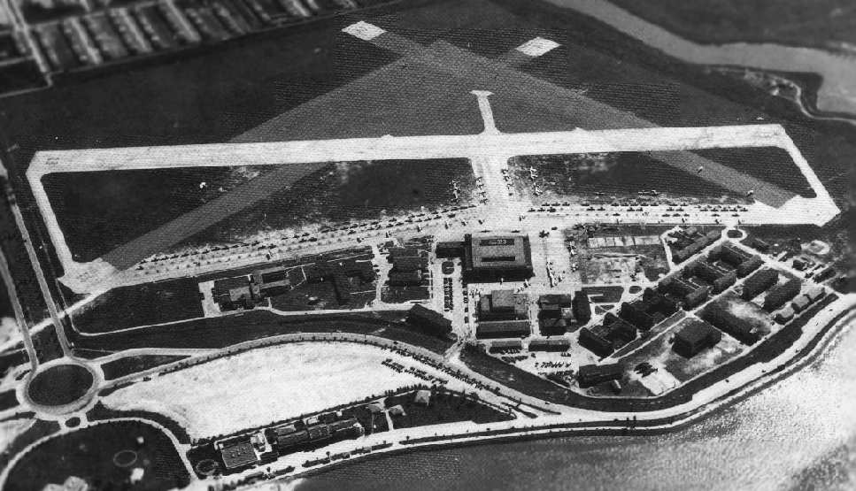
The 1951 USGS topo map depicted the 3 runways, taxiways, and ramps of “US Naval Air Sta” New Orleans.
The 1953 USGS topo map depicted the 3 runways, taxiways, and ramps of NAS New Orleans,
but the facility was unlabeled.
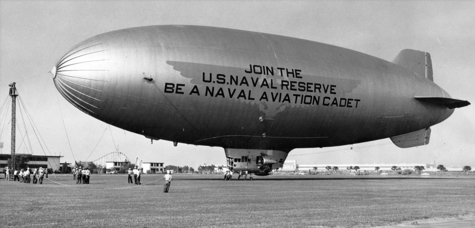
A 5/6/55 photo (courtesy of Gary Frey) looking northeast at a Navy blimp at the original NAS New Orleans NAS. Not the Pontchartrain Beach amusement park's Zephyr roller coaster in the background.
The September 1956 New Orleans Sectional Chart (courtesy of Chris Kennedy)
depicted NAS New Orleans as having a 3,400' hard surface runway.
The last photo which has been located showing aircraft at the original NAS New Orleans was a 1957 aerial view looking west (courtesy of Gary Frey),
showing a huge number of single-engine aircraft on the ramp.
As jet aircraft began to appear in the Reserves in the 1950s, the short runways of New Orleans became a liability.
The Navy built a new & larger facility adjacent to Alvin Callender NOLF, 15 miles southeast.
The new Naval Air Station New Orleans was opened in 1957, at which point the old field was apparently closed.
The multiple runways & single hangar of the former NAS New Orleans were still visible in a 1960 aerial view (courtesy of Carl Hennigan).
The 1961 USGS topo map still depicted 3 runways, taxiways, and ramps, labeled “U.S. Naval Air Station”.
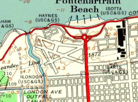
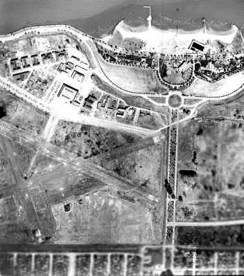
At some point between 1957-66, the location of the original Naval Air Station was reused as a Louisiana State University campus.
The 1966 USGS topo map no longer depicted any of the runways, instead showing roads & newly-constructed buildings,
labeled as “Louisiana State University (New Orleans Branch)”.
Dick Merrill recalled of the original Naval Air Station New Orleans, “I remembered flying over it in the early 1970s
and at that time you still could see a portion of runway.”
In the 1998 USGS aerial photo, no obvious trace remained of the former Naval Air Station.
Dick Merrill recalled in 2003, “Several years ago I drove around the campus of UNO & found what I think is a building dating back to the NAS days.
It looks like an old power plant building.
If you look at the north end of the campus near the levee, you will see a line which is the shadow of the brick smoke stack.
The streets and parking lots around the north end look like vintage paving also.
I think I saw a sign that hinted UNO was going to keep the building & make something else out of it.”
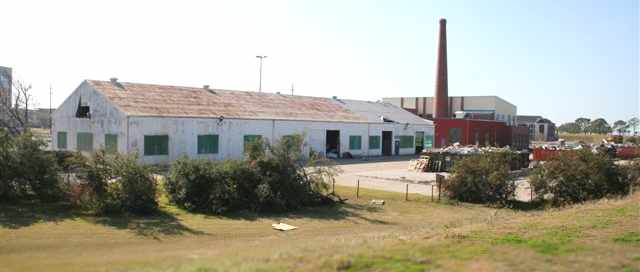
A 2005 photo by Dick Merrill of “the old WWII-vintage brick structure at old Navy New Orleans.
It looks like it survived Hurricane Katrina. The metal building is also of a similar vintage I think.”
Also note the WW2-vintage brick smokestack.
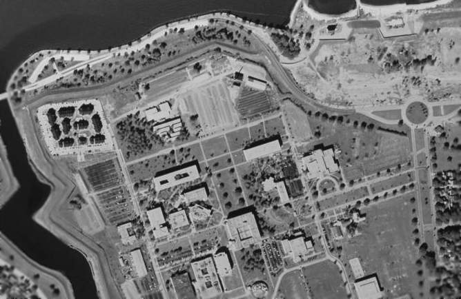
Bert Sausse reported in 2015 about “the former NAS New Orleans that has since been replaced by the University of New Orleans...
The smokestack did survive Katrina & has been incorporated into an alumni building.
There is a gravel parking lot that is on the north side of campus & just west of the smokestack.
Every now & then, depending upon the amount of traffic the parking lot sees that year, the gravel will part & portions of the airfield resurfaces.
It’s easily identifiable by the aircraft tie-downs that are still in the parking lot below.”
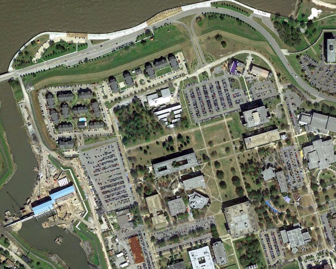
A 2017 aerial photo showed that the condition of the site of the original NAS New Orleans was not appreciably any different from that depicted in the 1998 photo.
The site of the original NAS New Orleans is located at the intersection of Founders Road & Levee Road.
____________________________________________________
Wedell-Williams Landing Field / Alvin Callender Municipal Airport /
Alvin Callender Naval Outlying Landing Field, Belle Chasse, LA
29.85, -90 (Southeast of New Orleans, LA)
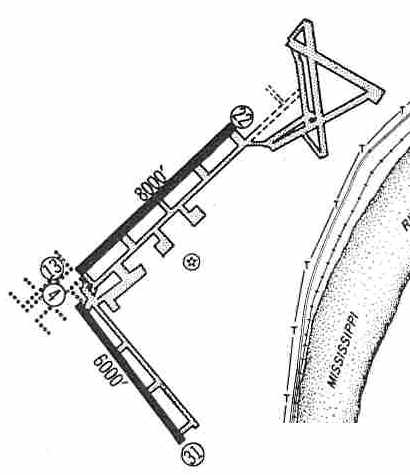
Wedell-Williams Landing Field, as depicted on the 1929 Air Trails Map (courtesy of Jonathan Westerling).
An airfield was first cleared on this site in the late 1920s for a nationwide tour by Charles Lindberg.
The earliest depiction which has been located of Wedell-Williams Field was on the 1929 Air Trails Map (courtesy of Jonathan Westerling).
The earliest directory listing which has been located of Wedell-Williams Field was on the 1929 Civil Aeronautics Administration Bulletin #2 (according to David Brooks).
It was listed as a municipal airport.
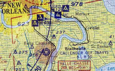
Alvin Calendar Field, as depicted on a 1929 New Orleans Association of Commerce map.
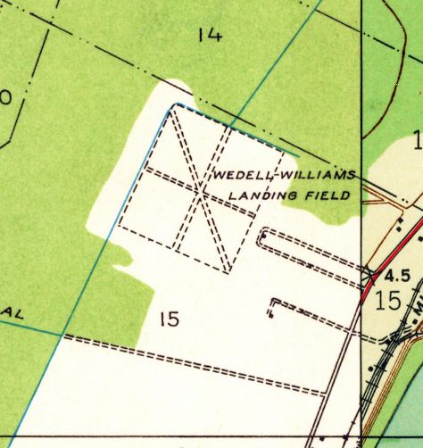
The earliest topo map depiction which has been located of this airfield was on the 1932 USGS topo map.
It depicted the “Wedell-Williams Landing Field” as being a square outline with 3 unpaved runways.
Note that this was a different airfield than another Wedell-Williams Airport eventually located a few miles to the west.
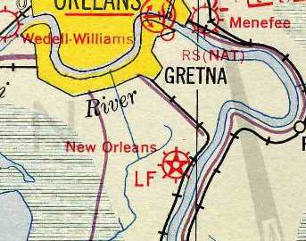
The field was labeled "New Orleans" Landing Field on the 1934 Navy Aviation Chart V-242 (courtesy of Chris Kennedy).
It was depicted as “Alvin Callender” on the 1935 New Orleans Sectional Chart (courtesy of Roger Connor).
The 1938 Descriptions of Airports & Landing Fields in The United States (according to David Brooks)
described the field as being located 8.75 miles southeast from the center of New Orleans.
It was said to consist of a 2,100' square field, with a 2,100' runway extension on the east side.
It was depicted on the 1939 New Orleans Sectional Chart (according to David Brooks) as a civil airport.
The 1940 USGS topo map depicted “Alvin Callender Field” as a small square outline, without any runway details.
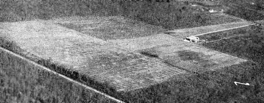
An aerial view looking northeast at the "Alvin Callender" Municipal Airport,
from The Airport Directory Company's 1941 Airport Directory (courtesy of Chris Kennedy).
The field was said to be a T-shape, measuring 2,000' x 2,000', with a 2,000' extension to the east.
A single hangar on the east side of the field was said to have "Airport" painted on the roof.
During WW2, the Navy built a modern airfield (with 3 paved runways)
on the Alvin Callender site as one of 8 satellite fields for New Orleans NAS.
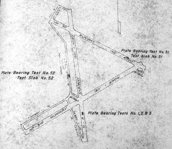
A 1944 Corps of Engineers Report (from the Air Force Historical Agency, courtesy of Ron Plante)
depicted the location of 30” plate bearing tests & concrete slabs on Alvin Callender Airport.
The airport was shown in its WW2 configuration, with 3 paved runways.
The July 1945 New Orleans Sectional Chart depicted “Callender (Navy)” as a military airfield.
The 1946 Haire Airport Directory (according to David Brooks) described Alvin Callender Municipal Airport
as being owned & operated by the city.
The 1947 USGS topo map continued to depict “Alvin Callender Field” as a small square outline, without any runway details.
The February 1947 Galveston Bay World Aeronautical Chart (according to David Brooks) depicted Alvin Callender as civil airport.
The 1948 Haire Airport Directory (according to David Brooks) described Alvin Callender Municipal Airport
as being owned & operated by the city.
But Callender OLF was depicted as a Navy airfield on the January 1949 New Orleans Sectional Chart (courtesy of Chris Kennedy)
The 1950 USGS topo map depicted “Alvin Callender Airport” as having expanded considerably toward the northeast compared to earlier topo maps,
with 3 paved runways & taxiways.
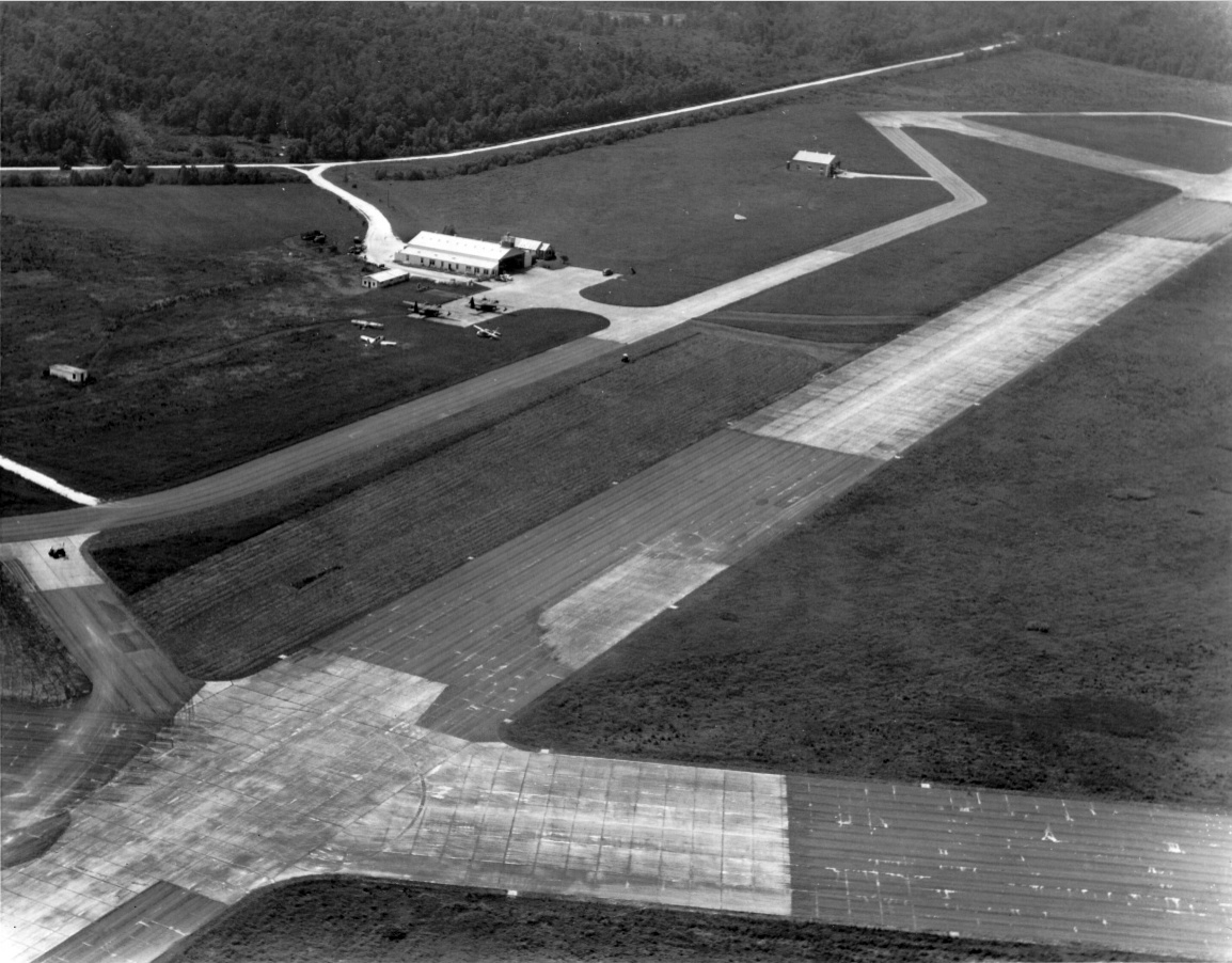
A 1952 aerial view looking northwest (courtesy of Gary Frey) at the west ramp & hangar of Alvin Callender Airport.
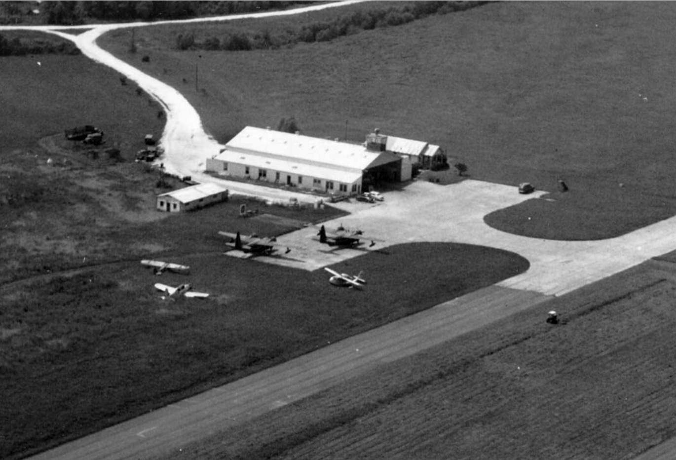
A closeup from the 1952 aerial view looking northwest (courtesy of Gary Frey) at the west ramp & hangar of Alvin Callender Airport,
showing 2 Grumman Albatross amphibians, a Republic SeaBee, and 2 light single-engine aircraft.
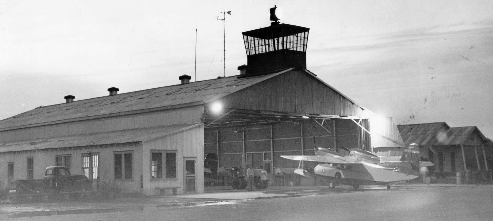
A 3/12/52 photo (courtesy of Gary Frey) a Grumman Widgeon operated by McDermott Construction in front of the Alvin Callender Airport hangar.
The 1953 Aviation Week Airport Directory (courtesy of David Brooks) listed the field as “Alvin-Callender Municipal Airport”.
It was described as having 3 paved runways, with the longest being the 5,000' north/south & northeast/southwest strips.
The field was said to offer hangars, repairs, and fuel, and the manager was listed as D.O. Langstaff.
Callender OLF was once again depicted as a Navy airfield on the August 1954 New Orleans Sectional Chart (courtesy of Chris Kennedy).
The 1954 USGS topo map continued to depict “Alvin Callender Airport as having 3 paved runways.
The last chart depiction which has been located of Callender OLF as an active airfields
was on the September 1956 New Orleans Sectional Chart (courtesy of Chris Kennedy).
The aerodromes table on the chart described Callender as having 3 runways, with the longest being a 5,000' strip.
A circa 1957 aerial view looking southwest (courtesy of Gary Frey) showing the original Alvin Callender Airport in the foreground
and the under-construction new NAS New Orleans in the background.
In 1957, the Navy needed to replace the original New Orleans NAS with a larger jet-capable facility,
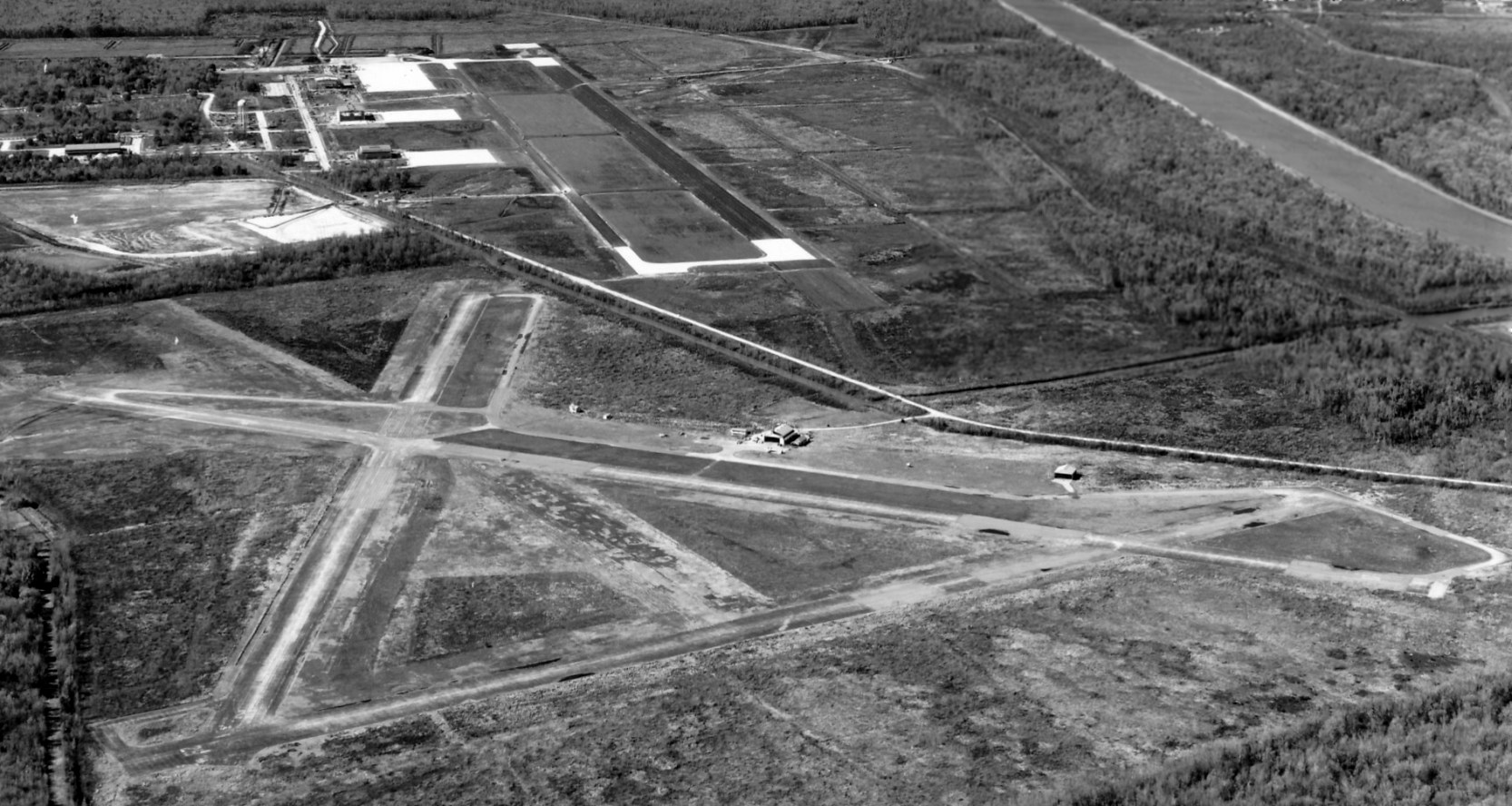
and a new airfield with 2 long runways was built adjacent to the southwest side of the old NOLF, on the opposite side of Olsen Avenue.
This field was dedicated as Alvin Callender Field in 1957, at which point the original field was presumably closed.
The 1960 Jeppesen Airway Manual (courtesy of Chris Kennedy
depicted the 3 abandoned runways of the Alvin Callender NOLF at the northeast corner,
along with the 2 newly-built runways of the new field.
The runways of the old Alvin Callender NOLF have apparently never been reused.
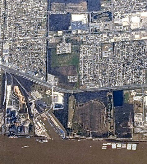
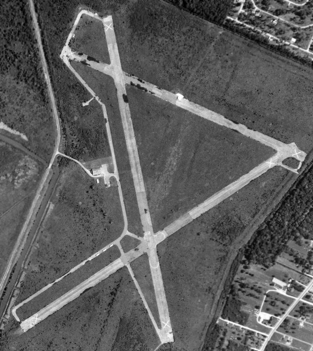
A 2/20/64 USGS aerial photo showed the old NOLF airfield consisted of 3 paved runways (the longest is 5,200'), taxiways, and the remains of a ramp north of the East/West runway.
There did not appear to be any buildings remaining at the site. The Harvey VORTAC beacon had been built over the former east/west runway.
The 2002 USGS aerial photo showed that the condition of the abandoned Alvin Callender airfield had not changed very much compared to the 1998 photo.
Alvin Callender Field sustained only minor damage from Hurricane Katrina in 2005
(being located at a higher elevation than downtown New Orleans).
It was then was used extensively by rescue helicopters in the aftermath of the flooding.
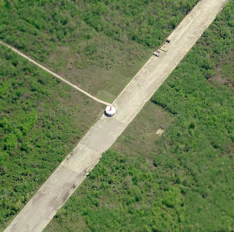
A circa 2006 aerial photo looking east at the Harvey VORTAC beacon which sits over the former east/west runway.
Bert Sausse reported in 2015, “Alvin Callender Field... the airfield is still attached to the current Naval Air Station via an alternate access road.
The Louisiana Air National Guard, based at NAS-JRB uses this area for additional parking when a major exercise is occurring on base.
Additionally, there are some training & support facilities that are currently lining the runways (as seen on [recent aerial] images).”
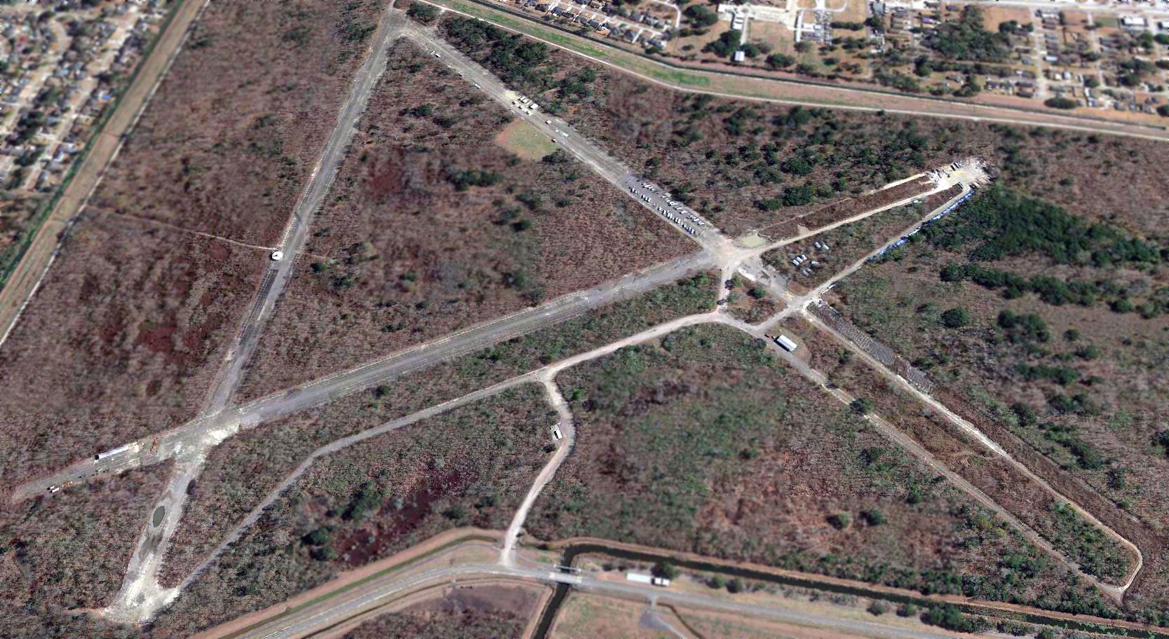
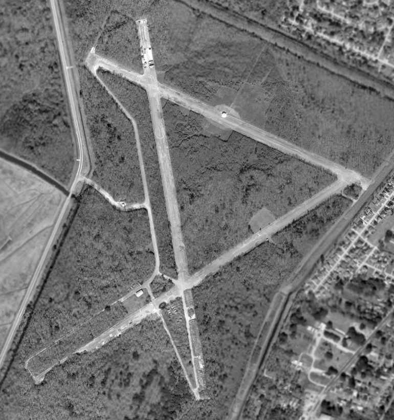
A 2018 aerial view looking east shows the runways & taxiways of the old Alvin Callender NOLF remain intact though deteriorated.
____________________________________________________
Or if you prefer to contact me directly concerning a contribution (for a mailing address to send a check),
please contact me at: paulandterryfreeman@gmail.com
If you enjoy this web site, please support it with a financial contribution.
____________________________________________________
This site covers airfields in all 50 states.