Abandoned & Little-Known Airfields:
Western Kansas
© 2002, © 2026 by Paul Freeman. Revised 3/13/26.
This site covers airfields in all 50 states: Click here for the site's main menu.
___________________________________________________
Please consider a financial contribution to support the continued growth & operation of this site.
Barney Scherr Airport (revised 3/13/26) - Dodge City AAF / Ford County Airport (revised 11/3/22) - Greensburg Airport / Paul Windle Municipal Airport (added 5/3/20) - Hutton Airport (revised 3/9/24)
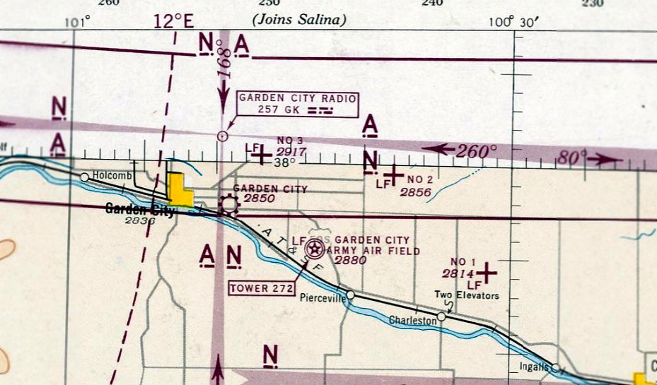
Garden City Aux AAF #1 / Ingalls Municipal Airport (revised 9/10/16) - Garden City Aux AAF #2 (revised 1/23/22)
Garden City Aux AAF #3 (revised 9/7/24) - (Original) Garden City Municipal Airport (revised 1/23/22) - Wilroads Gardens Airport (revised 3/13/26)
____________________________________________________
Barney Scherr Airport, Collyer, KS
39.034, -100.084 (Northwest of Wichita, KS)
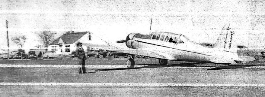
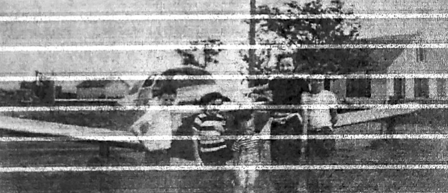
A 1947 photo (courtesy of B.J. Scherr) of Barney Scherr with Frank Lynch's Vultee BT-13 at Scherr Airport.
According to “Some memories of: The Barney Scherr Airport” by B.J. Scherr (courtesy of Roger Blew):
“I grew up on that farm a mile & a half east of Collyer.
Beginning in the early 1930s, dad would call in the local weather conditions to this airline in Kansas City on a regular basis & their plane would use our pasture when necessary.
Apparently, ours was the only field in the Collyer area that was flat enough & big enough & next to a good asphalt highway.
I remember the folks telling us that because of dad's service to the airline,
the airline gave them a free round-trip ticket to Chicago for their honeymoon in 1933.”
B.J. Scherr continued, “The earliest I remember a plane landing on that fairly flat pasture west of our house was around 1940.
The aircraft was a big, noisy, twin-engine rag job with a tailwheel.
It was a passenger plane belonging to some airline out of Kansas City.
I was about 6 or 7 years old & I remember looking into the open door on the right side of the fuselage & seeing the O'Toole boys & their dad strapped into wicker passenger seats,
waiting for the pilot to get aboard & crank up for a spin over the Collyer area.
I remember thinking, 'Boy, those wicker chairs belong in somebody' s sun porch.'”
B.J. Scherr continued, At the end of WW2 in 1945, many local men returned to Trego County from duty stations around the world.
One thing they all had in common was a government benefit called the 'GI Bill'.
It would pay for a college education or some kind of skill or craft training which could provide a livelihood for the veteran.
One thing these vets had in common was that they had been gallivanting around the country & the world the past few years and some had done a lot of piloting.
So, the idea of learning to pilot an aircraft probably seemed as good a way as any to spend the money & more fun than most.
To do this, there would have to be a flying school somewhere close-by.”
B.J. Scherr continued, “It was probably around 1945 that dad was approached by Ben Drieling regarding the idea of starting a flying school, using the pasture as the field.
Ben was a Collyer boy, a veteran pilot of WW2 & he brought in a couple of Aeronca Champion planes that were to be pilot trainers.
The Aeronca Champion had side-by-side controls & seating, unlike the J-3 Piper Cub which had tandem seating & controls,
weich made the Aeronca a more efficient trainer than the J-3 Cub.
One of the planes was stored inside the round-top north of the house & the other was tied down.
All this turned out to be temporary because dad & Ben never settled on an arrangement & Ben eventually was involved in a flying school in Salina.
B.J. Scherr continued, “Probably in 1947 there was more talk about a flying school.
I remember dad & George Parsons out west of the house in the pasture & they' re building a big, heavy rolling packer.
These 2 guys, before building the runways, they're building the heavy equipment to build the runways.
The north/south runway was on the east end of the field, about 100 yards west of our house.
The east/west runway was on the north side of the field & the diagonals cut through the center of the field , clearing a gully on the west end of the field.
Our front room picture window opened up to all of what was going on out there
and provided some excitement & a lot of entertainment over the years.”
B.J. Scherr continued, “At the beginning, the runways weren't lit & all planes had to be back in before sundown.
As soon as was possible, runway lights were purchased from an army surplus source.
Many of the airbases that existed in western KS during the war for the purpose of training bomber pilots & crews were closed down & I'm sure that's where our lights came from.
My brother Tim & I helped dad install those lights up & down the outer edge of each runway.
However before the lights were purchased, there was a 'snafu' over on the east/west runway which showed everybody what happens when Murphy's Law takes over after sundown on an unlit field.”
B.J. Scherr continued, “Art Richardson brought his Luscombe over to our field in the early days.
Frank Lynch brought his BT-13 over & George Galloway brought his Cessna to our field.
The first aircraft I remember George Parsons flying was a Taylorcraft; George called it his 'glorified kite'.
It wasn't long before George traded the Taylorcraft for a hot, sleek, low-wing aircraft with a lot of horsepower, a PT-19.
The PT-19 was the aircraft of choice for several local pilots.
Tony Malsom brought in his PT-19 & so did Joe Nedbalek.
Two or three people in the Collyer area had aircraft before the flying school began. They were good, careful pilots.
In those days you could buy very nice single-engine plane for less than $5,000 & some that were less than nice for $2,000 or less.
Flying lessons & ground school was not expensive; you could solo for around $200.”
B.J. Scherr continued, “After students began graduating & buying planes the number of aircraft & activity increased.
Dad built 2 hangars & 2 more later on. Dad was quite a builder.
They moved in a small frame building to be used for the flight office.
They hired 2 flight instructors & a girl to run the office.
They installed tanks & a fuel pump to dispense 90 octane fuel & they installed tie-down pads for parked aircraft.
They bought a couple of J-3 Piper Cubs for pilot trainers & a Piper be used as a charter plane.
This charter plane they bought was involved in the snafu I mentioned earlier.”
The earliest depiction which has been located of Scherr Airport was a 1947 photo (courtesy of B.J. Scherr) of Barney Scherr with Frank Lynch's Vultee BT-13.
B.J. Scherr recalled, “Mom said this is the one that rattled the windows when it took off.”
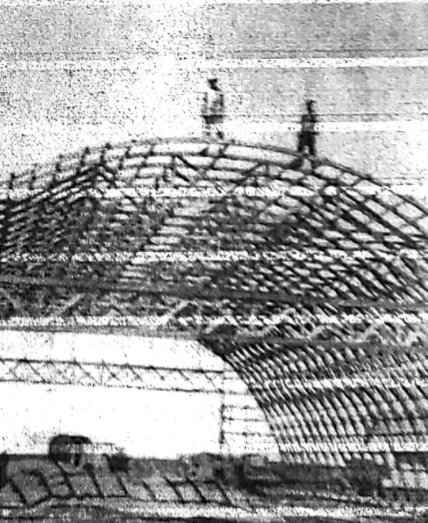
A 1947 photo (courtesy of B.J. Scherr) of head carpenter Ben McCartney & Barney Scherr building Scherr Airport's 100' x 60' round-top hangar.
Scherr Airport was not yet depicted on the September 1947 Salina Sectional Chart.
The earliest aeronautical chart depiction which has been located of Scherr Airport was on the September 1948 Salina Sectional Chart.
It depicted Scherr Airport as having a 3,200' unpaved runway.
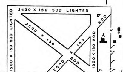
The only airport directory depiction which has been located of Scherr Airport was in the 1949 KS Airport Directory.
It depicted Scherr Airport as having no less than 5 sod runways, with the longest measuring 2,500' northwest/southeast.
A 7/3/49 photo (courtesy of B.J. Scherr) of Tim, Martha, Chuck, B.J.'s mom, and B.J. Scherr & an Ercoupe in front of their home at Scherr Airport.
B.J. Scherr continued, “There was never a fatality nor any real disaster; thank god for that.
The round-top hangar was destroyed by a tornado that went through our yard in 1953.
I believe the flying school closed in 1953.
The last depiction which has been located of Scherr Airport was on the May 1957 Salina Sectional Chart.
The depicted runway length had decreased to 2,500'.
Scherr Airport was evidently closed at some point in 1957,
as it was no longer depicted on the December 1957 Salina Sectional Chart.
Scherr Airport was not depicted on the 1979 USGS topo map,
and a 1981 aerial view showed no recognizable trace of an airfield.
A 2016 aerial view showed no recognizable trace remaining of Scherr Airport.
Thanks to Roger Blew for pointing out this airfield.
____________________________________________________
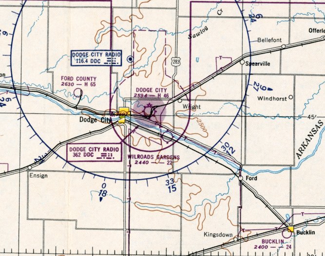
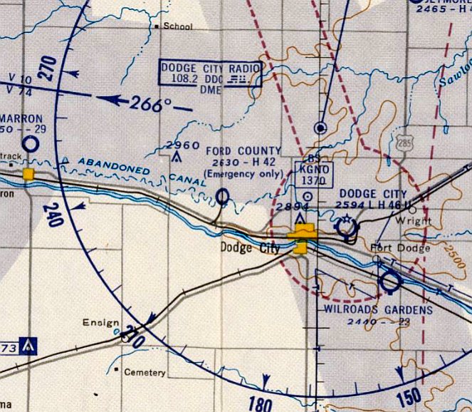
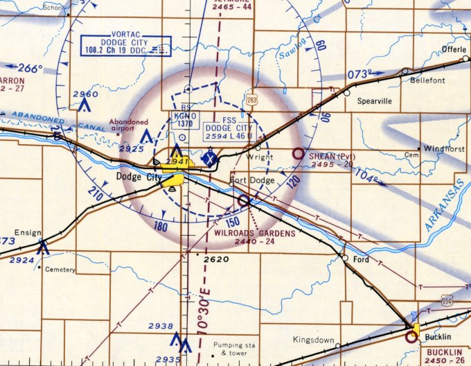
Wilroads Gardens Airport (9K1), Dodge City, KS
37.721, -99.924 (West of Wichita, KS)
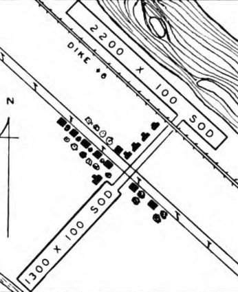
Wilroads Gardens Airport, as depicted in the 1949 KS Airport Directory.
Wilroads Gardens Airport was evidently established at some point between 1946-49,
as it was not yet depicted on the March 1946 Wichita Sectional Chart.
The earliest depiction which has been located of Wilroads Gardens Airport was in the 1949 KS Airport Directory.
It depicted Wilroads Gardens Airport as having a 2 perpendicular sod runways, measuring 2,200' northwest/southeast & 1,300' northeast/southwest.
The earliest aeronautical chart depiction which has been located of Wilroads Gardens Airport was on the May 1950 Wichita Sectional Chart.
It depicted Wilroads Gardens Airport as having a 2,200' unpaved runway.
The June 1959 Wichita Sectional Chart depicted Wilrose Gardens Airport as having a 2,200' unpaved runway.
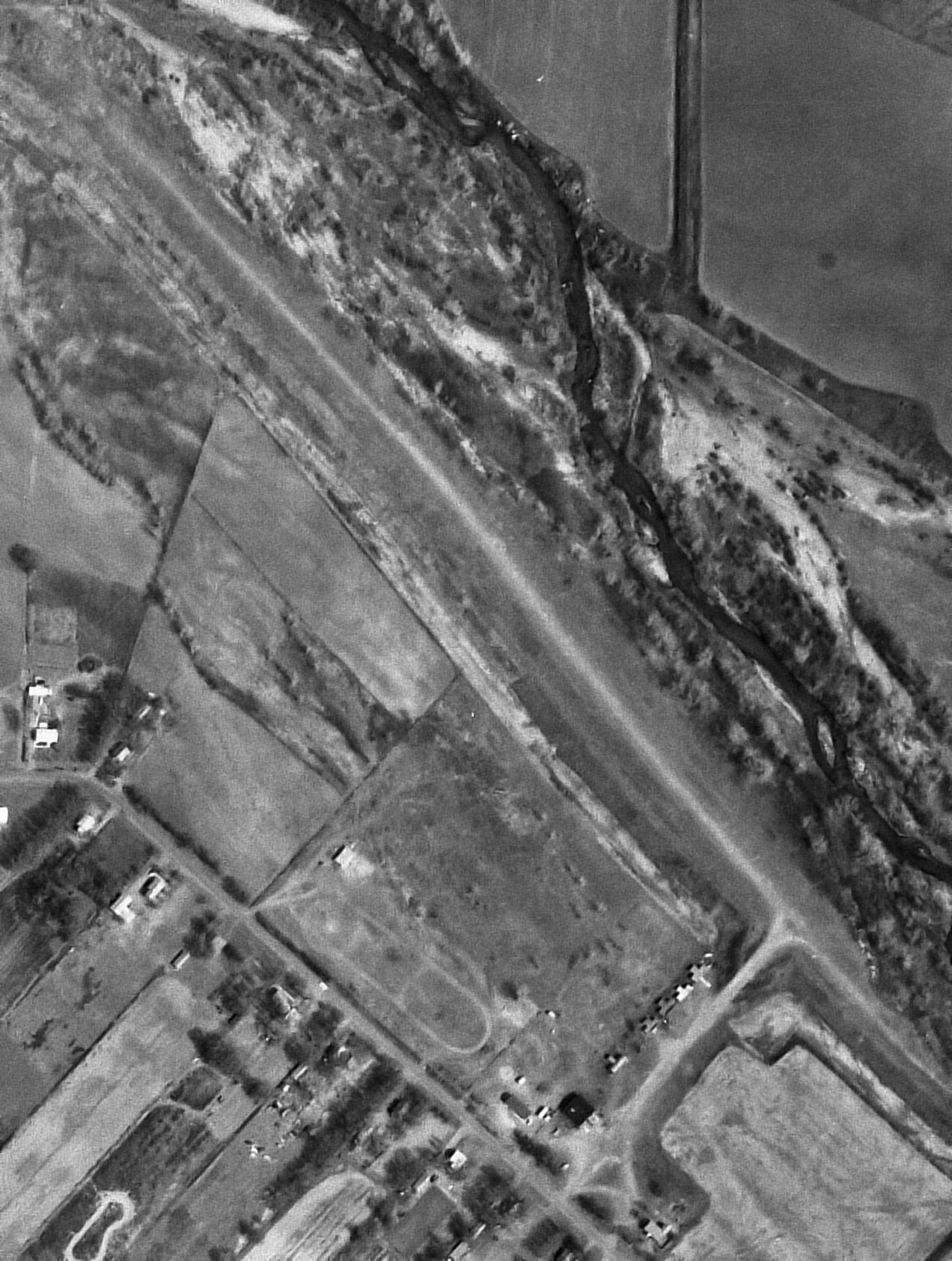
The earliest photo which has been located of Wilroads Gardens Airport was a 3/26/65 USGS aerial view.
It depicted a single unpaved northwest/southeast unpaved runway, with a small hangar & 5 T-hangars on the south side.
There were no aircraft visible on the field.
Wilroads Gardens Airport may have been closed (for reasons unknown) at some point between 1965-66,
as a 1966 aerial photo showed the 5 T-hangars had been removed at some point between 1965-66.
The last aeronautical chart depiction which has been located of Wilroads Gardens Airport was on the January 1969 Wichita Sectional Chart.
It depicted Wilroads Gardens Airport as having a 2,400' unpaved runway.
Wilroads Gardens Airport was not depicted at all on the 1969 USGS topo map.
Ed Noulin recalled, “I used to fly in & out of Dodge City back in the mid-1980s, but don’t ever remember seeing the Wilroads Garden airport, so must have been completely gone by then.”
A 1991 USGS aerial view looking northeast showed the Wilroads Gardens Airport runway remained intact, along with the 1 hangar on the south end.
As of 2008, Wilroads Gardens Airport was still listed with the FAA as a public-use airport, owned by Wayne Neese.
It was said to have a single 2,630' turf Runway 14/32, in “poor condition”,
to have 5 aircraft based on the field, and to conduct an average of 16 takeoffs or landings per month.
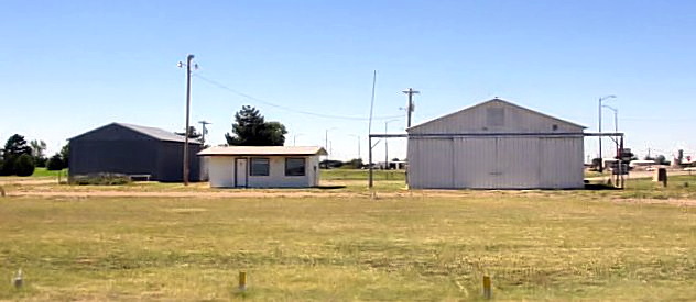
An April 2012 photo looking north at the remaining Wilroads Gardens Airport hangar (courtesy of Lee Corbin) showed it considerably deteriorated but still intact.
A 2016 aerial view looking northeast showed the Wilroads Gardens Airport runway remained clear but no longer recognizable.
The sole hangar remained standing on the south end.
Wilroads Gardens Airport was no longer listed with the FAA as of 2020.
Thanks to Lee Corbin for pointing out this airfield.
____________________________________________________
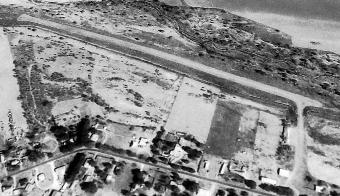
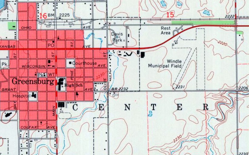
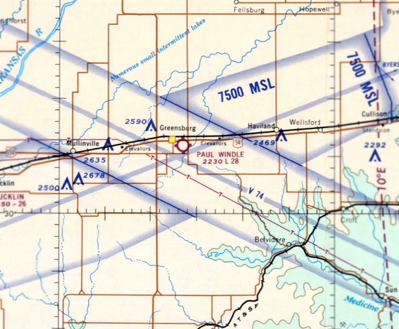
Greensburg Airport / Paul Windle Municipal Airport (8K7), Greensburg, KS
37.606, -99.275 (West of Wichita, KS)
Greensburg Airport, as depicted on the March 1946 Wichita Sectional Chart.
Photo of the airport while in use is not available.
Greensburg Airport was evidently established at some point between 1945-46
(like hundreds of other small airports in the American post-WW2 aviation boom),
as it was not yet depicted on the September 1945 Wichita Sectional Chart.
The earliest depiction which has been located of Greensburg Airport was on the March 1946 Wichita Sectional Chart.
According to Wikipedia, Greensburg Airport was renamed Paul Windle Municipal Airport in honor of Capt. Paul Windle
who learned to fly at this airport & was killed in action in 1965 during the Vietnam War.
It was owned by the City of Greensburg, covered an area of 71 acres, and had 2 turf runways: 2,600' Runway 2/20 & 2,400' Runway 17/35.
The earliest photo which has been located of Windle Airport was a 1965 aerial view.
It depicted Windle Airport as having 2 grass runways, with a small hangar & 1 light single-engine aircraft on the northwest side.
The 1969 USGS topo map (courtesy of Lee Corbin) depicted Paul Windle Airport as 2 unpaved runways & several small buildings on the northwest side.
The last aeronautical chart depiction which has been located of Paul Windle Airport was on the December 1969 Wichita Sectional Chart.
It depicted Paul Windle Airport as having a 2,800' unpaved runway.
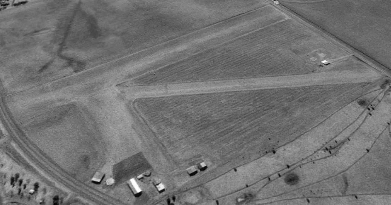
The earliest photo which is available of Windle Airport was a 1996 USGS aerial view looking southeast.
It depicted Windle Airport as having 2 grass runways, with several small hangars on the northwest side.
There were no aircraft visible on the field.
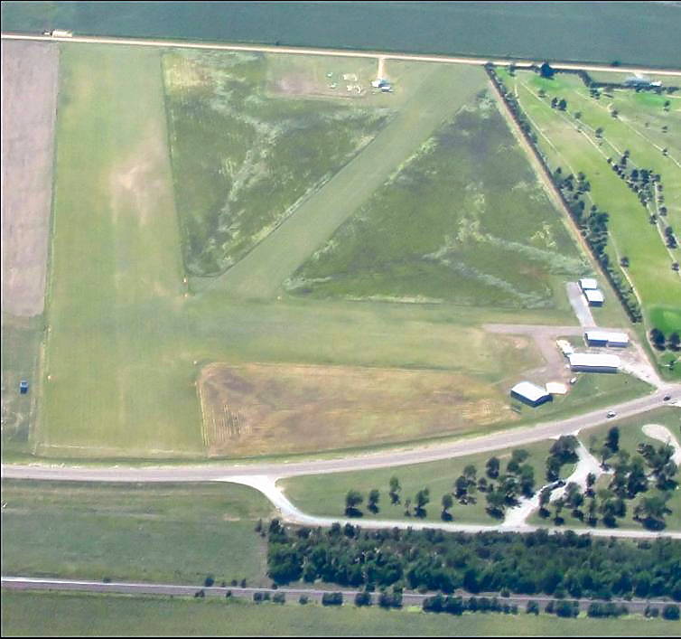
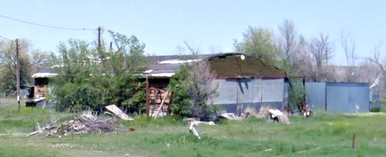
A 2010 aerial view looking south at Windle Airport (courtesy of Lee Corbin).
A 2010 photo of 2 hangars & the airport office at Windle Airport (courtesy of Lee Corbin).
The last photo which has been located showing Windle Airport still intact was a 2010 aerial view looking southeast.
The airport configuration was unchanged compared to the 1996 photo.
As of 2010, the city of Greensburg was considering closing Paul Windle Airport.
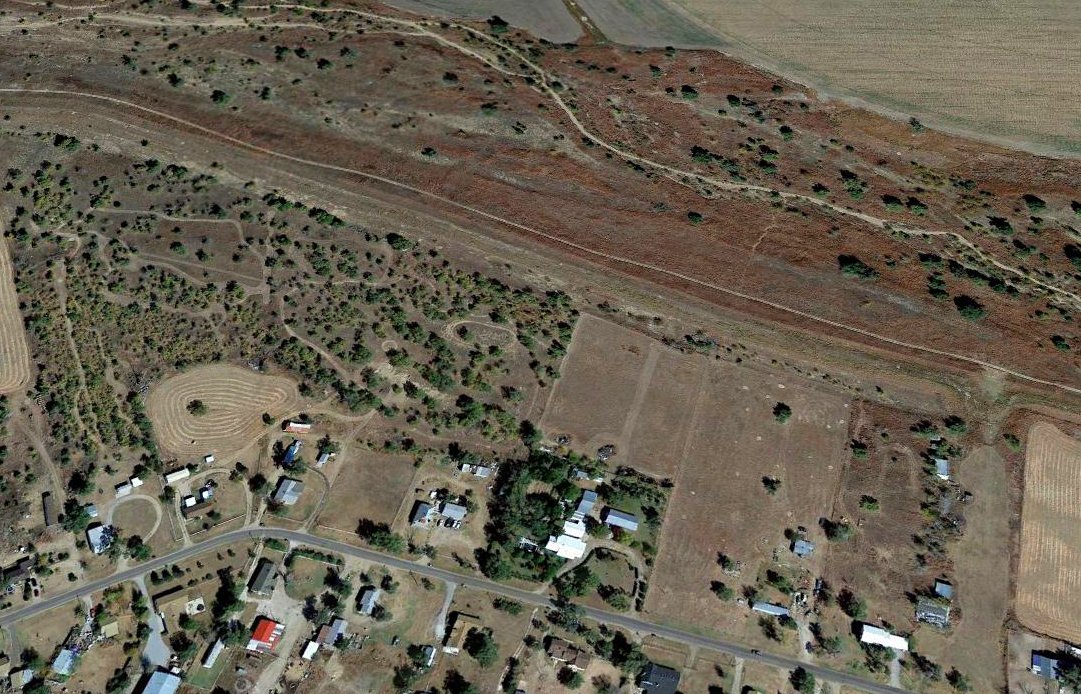
Paul Windle Airport was evidently closed at some point between 2010-2016,
as it was no longer depicted on the July 2016 Wichita Sectional Chart.
A 2017 aerial view looking southeast at the site of Paul Windle Airport showed Cottonwood Street had been built through the center of the property, and only faint traces of the 2 runways remained recognizable.
All of the hangars had been removed at some point between 2010-2017.
Thanks to Lee Corbin for pointing out this airfield.
____________________________________________________
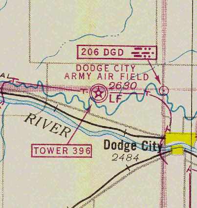
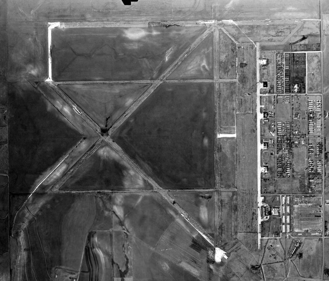
Dodge City Army Airfield / Ford County Airport, Dodge City, KS
37.798, -100.117 (West of Wichita, KS)
Dodge City AAF was located 6 miles northwest of the town of Dodge City.
Construction of the Dodge City base commenced on 8/6/42, according to “Survey Report of World War II Air Bases in Kansas” by Susan Ford.
Dodge City Army Airfield was built for the 70,000 Pilot Training Program,
to train pilots & crews of medium bombers, primarily Martin B-26 Marauders.
According to an Army Corps of Engineers report, Dodge City AAF encompassed a total of 2,560 acres.
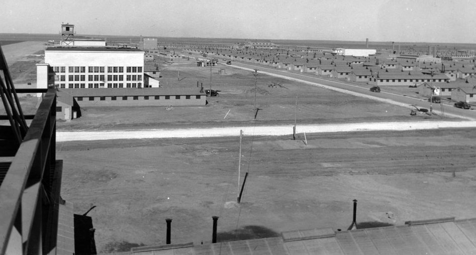
A 1/26/43 view looking north from Dodge City Army Airfield's control tower, showing hangars & other buildings.
A 1945 Army facilities inventory report indicated Dodge City Army Airfield cost approximately $8.1million to build (according to Rex Ricks).
Dodge City was also used during WW2 to train French aircrews (as covered in a French-language web site).
A 5/15/43 AAF list of airfields of the Gulf Coast Training Center (courtesy of Ron Plante)
described Dodge City as having 4 asphalt 6,500' runways & one satellite field: Auxiliary #4A.
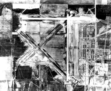
A 10/7/43 aerial view looking north from the 1945 AAF Airfield Directory (courtesy of Scott Murdock)
depicted Dodge City AAF as having 3 paved runways, a huge paved ramp, and several hangars.
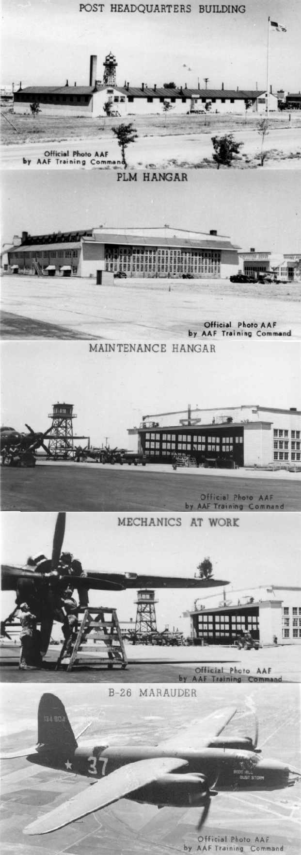
A series of photos of Dodge City AAF in 1943.
The earliest chart depiction of Dodge City AAF which has been located
was on the February 1944 Wichita Sectional Chart (courtesy of Chris Kennedy).
The 1944 US Army/Navy Directory of Airfields (courtesy of Ken Mercer) described Dodge City AAF as having a 6,500' hard-surface runway.
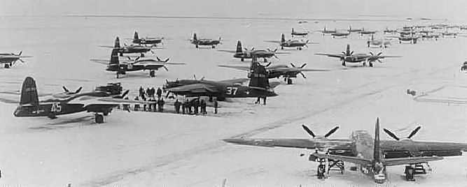
A circa 1940s photo of B-26 Marauder bombers on the snow-covered apron of Dodge City AAF (courtesy of Rex Ricks).
They were used by the base's advanced twin-engine school.
"Dodge City AAF" was still depicted as an active military airfield on the March 1945 Wichita Sectional Chart (courtesy of Chris Kennedy).
The 1945 AAF Airfield Directory (courtesy of Scott Murdock) described Dodge City AAF
as a 2,536 acre square-shaped property having 3 bituminous 6,500' runways.
The field was said to have 5 wooden hangars, the largest being a 202' x 162' structure.
The field was said to be owned by the U.S. Government & operated by the Army Air Forces, and to have one auxiliary field: #4 Jetmore Field.
The Army is reported to have departed Dodge City AAF in 1945.
However, it was still labeled "Dodge City AFB" on the March 1949 Wichita Sectional Chart (courtesy of Chris Kennedy).
It was depicted as having a 6,500' hard-surface runway.
At some point within 1949 the field apparently transitioned to a civilian airport,
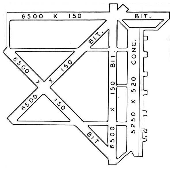
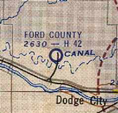
as it was listed as "Dodge City Municipal Airport (Ford County)" in the 1949 KS Airport Directory (courtesy of Chris Kennedy).
It was depicted as having four 6,500' bituminous runways & a 5,250' long concrete ramp along the east side of the field.
Strangely, no hangars were depicted in the airfield diagram in the 1949 airport directory - had they all been removed by this time?
The airport was not attended, and the manager was listed as William Meade.
"Ford County" was still depicted on the on the May 1950 USAF Wichita Sectional Chart as having a 6,500' hard surface runway.
Within the next 4 years the Ford County Airport apparently lost some of its runway length,
as the June 1954 USAF Wichita Sectional Chart (courtesy of Chris Kennedy)
depicted Ford County's longest runway as having gone down to 4,200'.
A 12/19/54 USGS aerial photo did not show any aircraft visible at Ford County Airport.
Ford County Airport was not depicted at all on the 1955 USGS topo map.
The last aeronautical chart depiction which has been located of Ford County Airport was on the June 1959 Wichita Sectional Chart.
It depicted Ford County Airport as having a 4,200' paved runway, but for “Emergency only”.
Ford County Airport was evidently closed at some point in 1959,
as it was no longer depicted on the December 1959 Wichita Sectional Chart.
The airfield & its buildings were subsequently reused for a variety of commercial purposes.
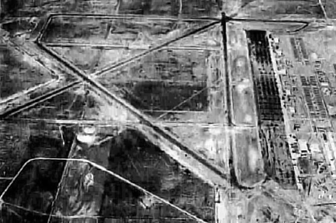
The extensive aviation infrastructure of Dodge City AAF had deteriorated quite a bit by the time of a 3/6/65 USGS aerial photo.
Chuck Regnier recalled, “From 1976 I lived in Dodge City.
I was in the truck driving class which was located at the old airfield.
At that time there were 3 hangars, two unknown buildings & the old firehouse still standing.
We used the parking areas & taxiways in front of the hangars,
once in a while we would run up & down the southeast/northwest runway.
The others were in such poor condition that the trucks would have been severely damaged had we ventured out on them.
Also the guard shack at the old maingate was still standing. This disappeared in 1974.
In 1975 while employed as a firefighter for the Ford County Fire Department
we were dispatched to the airfield on a structural fire.
The old firehouse was on fire. It had been turned into a residence.
Some of the original wiring caught fire. The building was later demolished.”
The runways of the former Dodge City airfield were not depicted at all on the 1984 USGS topo map, just the adjacent street grid.
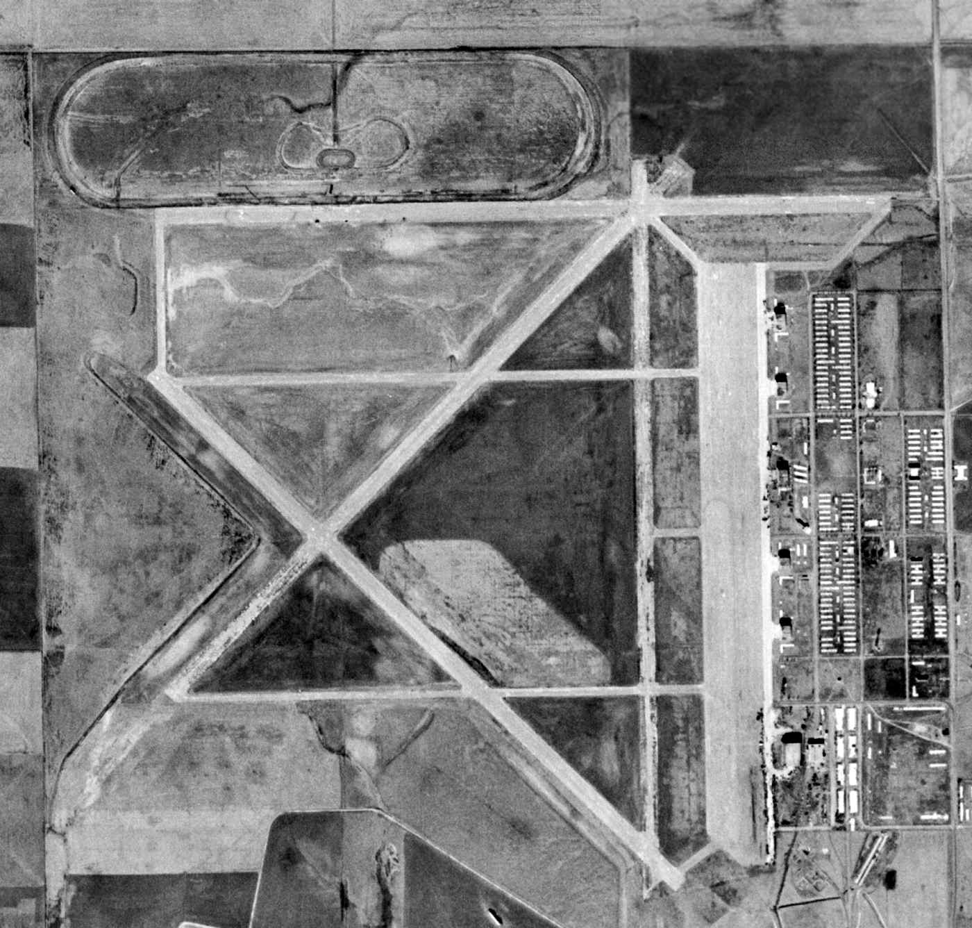
As seen in the 1991 USGS aerial photo, 4 paved runways (the longest is 7,000') & taxiways still existed, but were being progressively removed for farming.
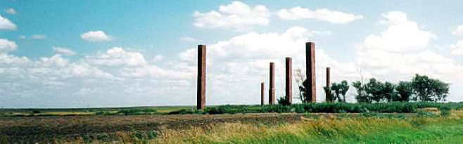
A 1999 photo by Steffani Day of the some of the remaining erect structures at the former Dodge City AAF - brick chimneys.
Dodge City resident Steffani Day reported in 2003 that the brick chimneys pictured above
"(and a few old building foundations) are the only part of the facility that a passerby can get close to.
The hangar and, I assume, the runways have been gated by the current owner."
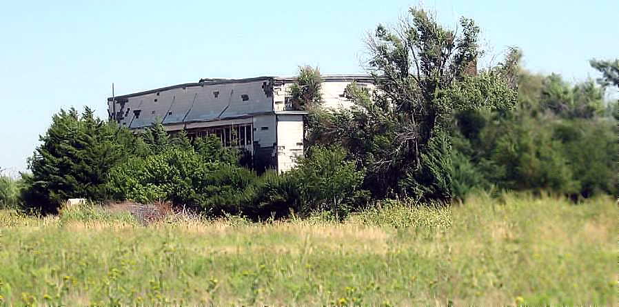
A 2007 photo by Scott Murdock of a Dodge City hangar which remains standing, heavily overgrown.
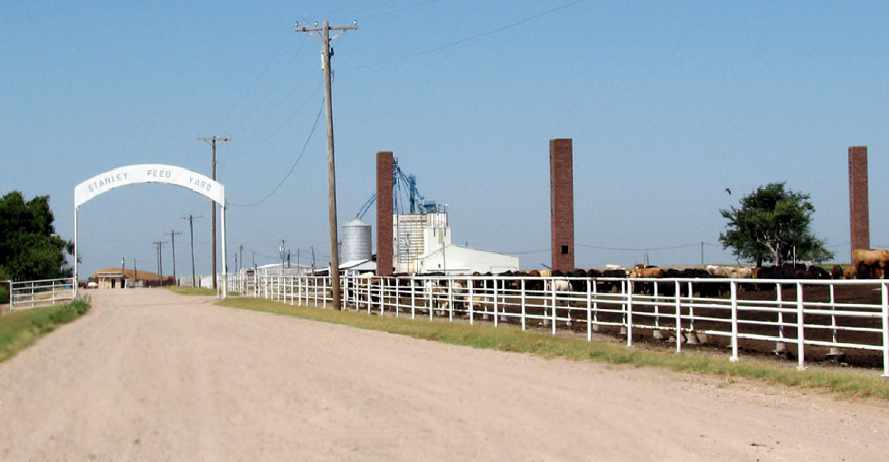
A 2007 photo by Scott Murdock of a the entrance to the Stanley Feed Yard, which occupies the site of Dodge City AAF.
Brick chimneys remain from the former airfield buildings.
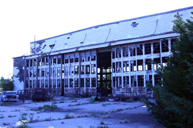
A 7/15/08 photo by Susan Ford of a Dodge City hangar which remains standing, heavily overgrown.
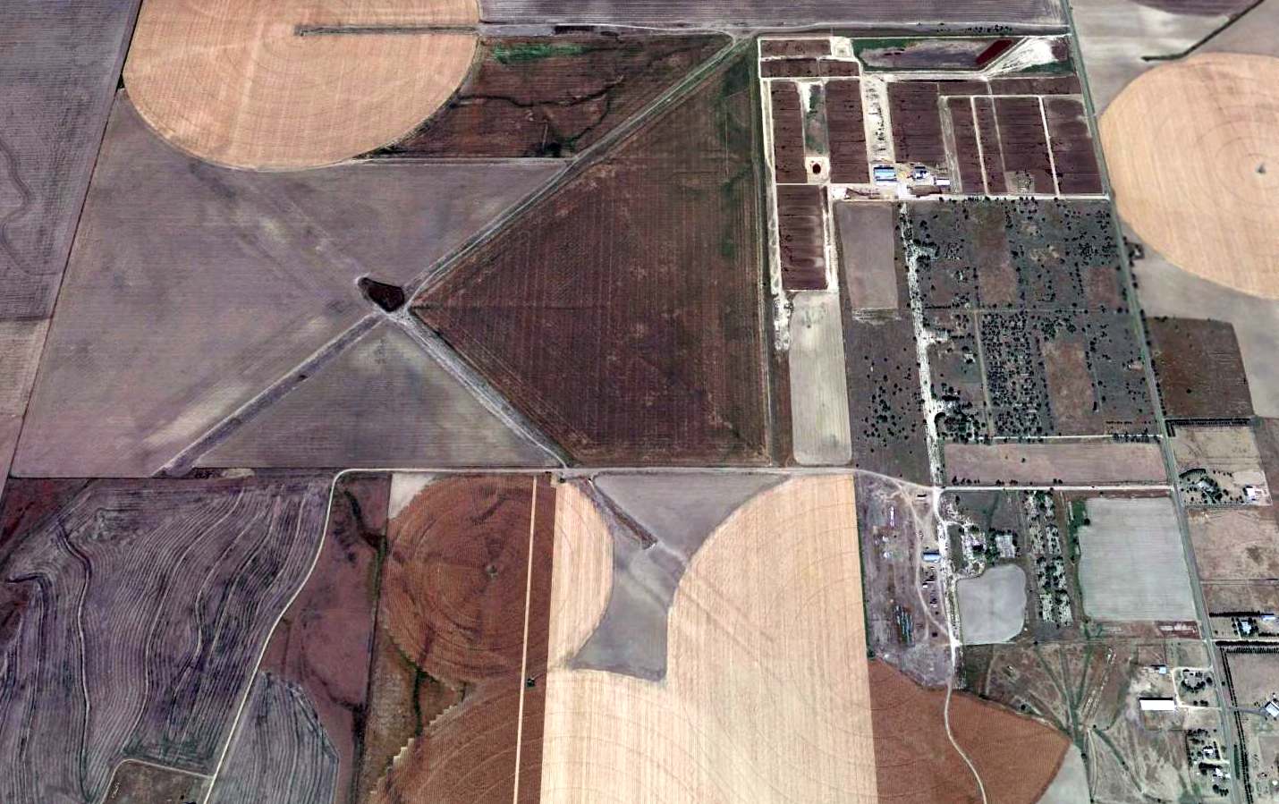
A 2013 aerial view looking north showed the remains of the extensive Dodge City airfield.
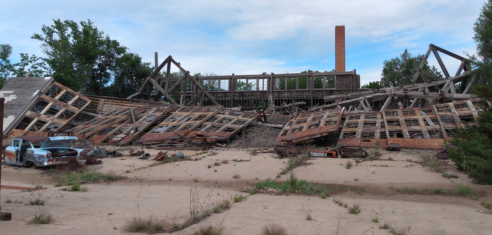
A sad May 2020 photo by Rex Ricks of the collapsed remains of a Dodge City hangar.
Rex reported, “The history of this field post World War Two literally stinks. It saw no aviation reuse. Much of the once bustling bomber base is now a nasty smelling feedlot. What a bunch of bullcrap!”
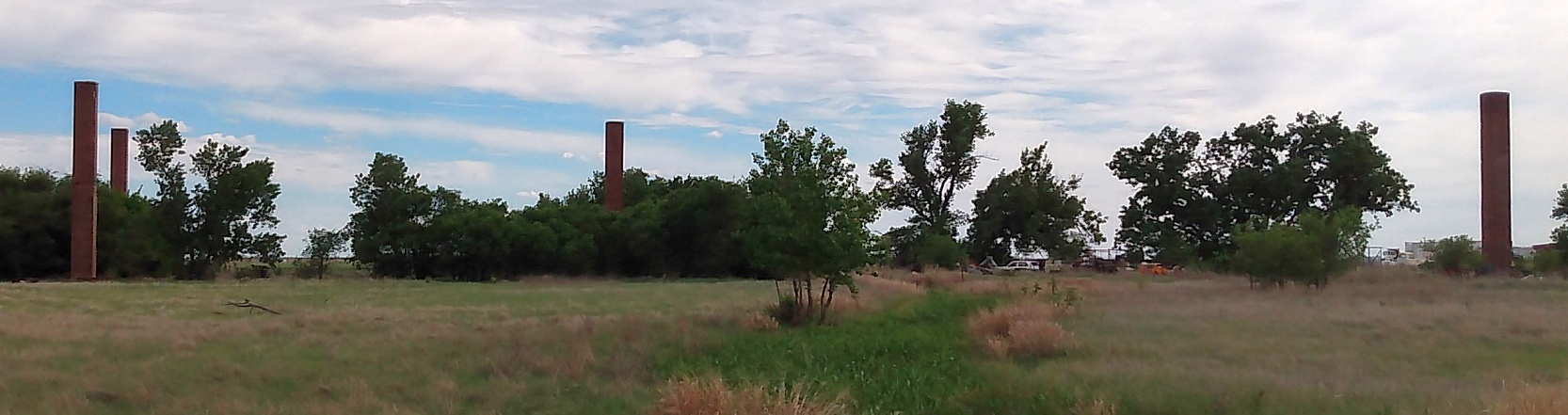
A May 2020 photo by Rex Ricks of the remaining brick chimneys at the site of Dodge City AAF.
A May 2020 photo by Rex Ricks of the remains of airfield pavement at the site of Dodge City AAF.
____________________________________________________
39.358, -101.365 (West of Wichita, KS)
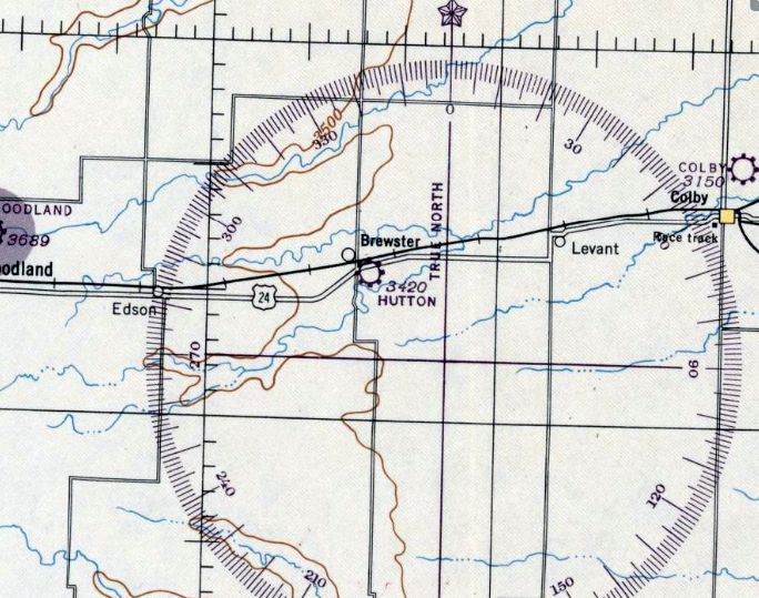
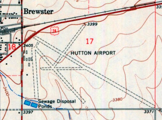
Hutton Airport, as depicted on the March 1946 Salina Sectional Chart.
This small general aviation airport on the southeast side of Brewster was evidently established at some point between 1945-46
(like hundreds of other small airports in America's post-WW2 aviation boom),
as it was not yet depicted on the September 1945 Salina Sectional Chart.
The earliest depiction which has been located of Hutton Airport was on the March 1946 Salina Sectional Chart.
It depicted Hutton Airport as a commercial/municipal airport.
The earliest photo which has been located of Hutton Airport was on an 8/24/53 USGS aerial view.
It depicted Hutton Airport as having 2 unpaved runways, and 4 hangars on the west side.
Hutton Airport, as depicted on the 1959 USGS topo map.
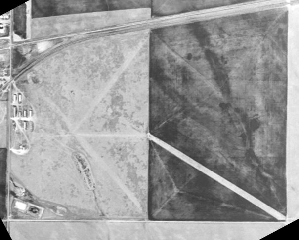
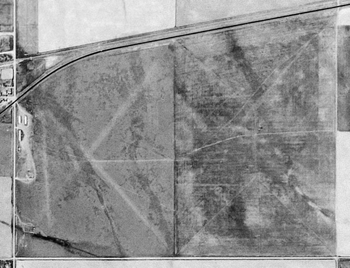
The last photo which has been located of Hutton Airport was on a 1966 USGS aerial view (courtesy of Lee Corbin).
The airfield had been expanded considerably toward the east, now totaling 5 runways, and the number of hangars had also increased to 8.
The 1966 USGS topo map (courtesy of Lee Corbin) depicted Hutton Airport as having no less than 5 unpaved runways, and a cluster of at least 8 hangars on the west side.
Lee Corbin observed, it must have been established by “a pilot who owned a bulldozer.”
Hutton Airport was evidently closed (for reasons unknown) at some point between 1966-91,
as the 1991 USGS aerial view depicted the runways as still recognizable but much less distinct.
The hangars remained on the west side, but no aircraft were visible, nor was there any other sign of recent aviation use.
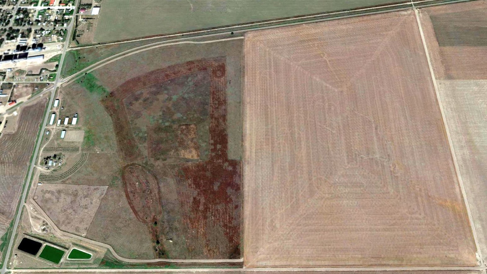
A 2014 aerial view looking north showed the airfields area of Hutton Airport had been returned to agriculture, with the runways no longer recognizable,
but the hangars remained on the west side.
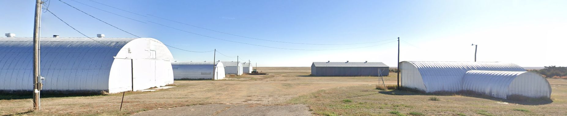
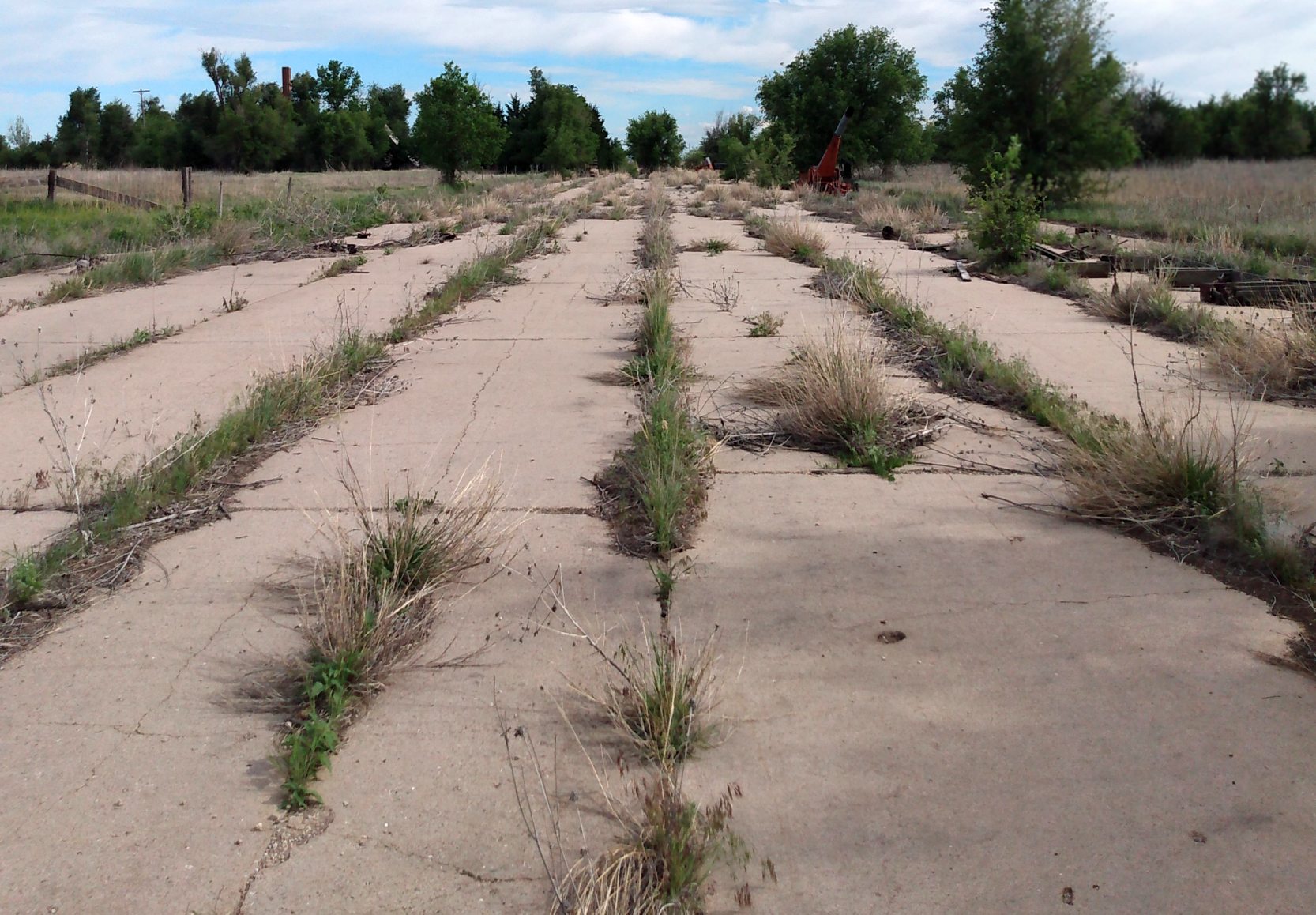
An October 2021 photo looking east at former hangars & other agricultural buildings along the northwest side of the Hutton Airport site.
Thanks to Lee Corbin for pointing out this airport.
____________________________________________________
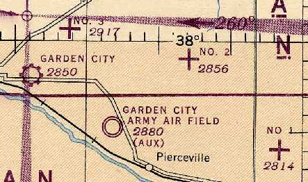
(Original) Garden City Municipal Airport, Garden City, KS
37.97, -100.82 (West of Wichita, KS)
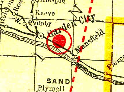
The original Garden City Airport, as depicted on the 1929 Rand McNally Standard Indexed Map with Air Trails of KS (courtesy of Chris Kennedy).
The original Garden City Municipal Airport was located approximately 2 miles east of the center of the town.
The Garden City Airport was evidently constructed in 1928,
as described in an article by Murriel Keiser in the 4/23/28 issue of Aviation Magazine (courtesy of Chris Kennedy).
It said “With the erection of an airport, the installation of a Porterfield Flying School,
and the organization of an N.A.A. Chapter, Garden City has become a center of air travel in southwestern KS.
One winged cavalcade flew into the airport shortly after its completion this spring.
The airport is bordered by a 4' white lime ribbon which marks the edge of a 1,320' x 2,640' field.
Twenty acres of sod near the administration building affords ample space for small planes to takeoff & land.”
The earliest depiction of Garden City Airport which has been located
was on the 1929 Rand McNally Standard Indexed Map with Air Trails of KS (courtesy of Chris Kennedy).
It described Garden City as a municipal field, operated by C.B. Eggen.
The field was described as measuring 2,640' x 1,320'.
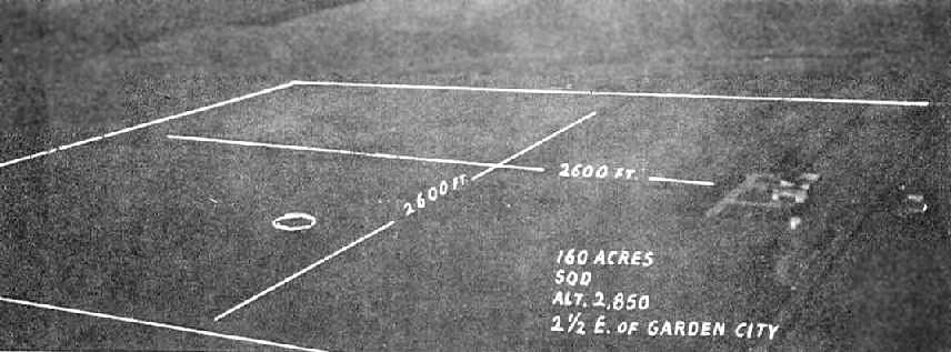
An undated aerial view of Garden City Municipal Airport, from The Airport Directory Company's 1933 Airports Directory (courtesy of Chris Kennedy).
The directory described Garden City Municipal Airport as consisting of a 160-acre square sod field,
having two 2,600' cinder runways, oriented north/south & east/west.
The field was said to provide fuel, repairs, and storage. The operator was listed as the Garden City Flying Service.
The earliest aeronautical chart depiction of the original Garden City Airport which has been located was on the March 1933 Wichita Sectional Chart.
It depicted Garden City as a commercial/municipal airport.
The Airport Directory Company's 1937 Airports Directory (courtesy of Bob Rambo)
described Garden City Municipal Airport as having a 2,600' square sod landing area.
According to Drew Van Horne, "Continental Air Lines inaugurated service into the Original Garden City Municipal Airport
late in 1938 utilizing Lockheed 10-E equipment on a Denver to Wichita routing via Colorado Springs,
Pueblo (original airport) and Garden City with 1 flight a day in each direction."
A 10/6/43 aerial view looking north from the 1945 AAF Airfield Directory (courtesy of Scott Murdock)
depicted Garden City Municipal Airport as having 4 unpaved runways, with several small hangars on the southeast side.
The Garden City Airport was described by the 1944 US Army/Navy Directory of Airfields (courtesy of Ken Mercer)
as having a 4,300' unpaved runway, which the remarks said was "unsafe for heavy aircraft."
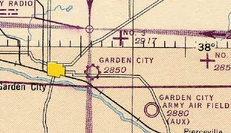
Garden City Airport, as depicted on the 1945 Wichita Sectional Chart (courtesy of Chris Kennedy).
The 1945 AAF Airfield Directory (courtesy of Scott Murdock) described Garden City Municipal Airport
as a 255 acre irregularly-shaped property having 4 dirt runways, the longest being the 4,488' northwest/southeast strip.
The field was said to have two 90' x 62' metal hangars,
to be served by Continental Air Lines, and to be owned & operated by the City of Garden City.
After the much larger Garden City Army Airfield (to the southeast) had been declared excess by the military in 1947,
it became the new Municipal Airport for the town of Garden City.
The old airport apparently continued in operation for a few more years though,
as both the old airport, labeled "Garden City (Mun)", and the "New Garden City" Airport
were depicted on the March 1949 Wichita Sectional Chart (courtesy of Chris Kennedy).
"Garden City Municipal Airport", as depicted in the 1949 KS Airport Directory (courtesy of Chris Kennedy).
The 1949 KS Airport Directory (courtesy of Chris Kennedy) depicted Garden City Municipal Airport as having 4 sod runways,
with the longest being the 4,422' northwest/southeast strip.
A total of 4 buildings (hangars?) were situated at the southeast corner of the field.
The airport offered repairs & fuel, and the operator was listed as M. M. Higins.
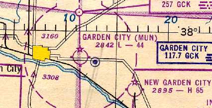
The original Garden City Municipal Airport was still depicted as an active airfield
on the October 1950 Wichita Sectional Chart (courtesy of Chris Kennedy).
The last photo which has been located showing the original Garden City Municipal Airport still intact was a 12/19/54 USGS aerial view.
It depicted the field as having 3 runways, with a few small buildings on the southeast side.
The original Garden City Airport was no longer depicted on the 1955 USGS topo map or later topo maps.
According to Drew Van Horne, "The latest reference I could find for the Original [Garden City] Airport
was in my 1956 Aviation Week Airport & Business Flying Directory."
It described the Garden City Airport at 37-57/100-49 as having 3 unpaved runways,
with the longest being a 4,422' north-northwest/south-southeast strip.”
According to Drew Van Horne, "My 1961 Aviation Week Airport & Business Flying Directory does not list the airport,
so the airport was presumably closed down sometime between 1956-61."
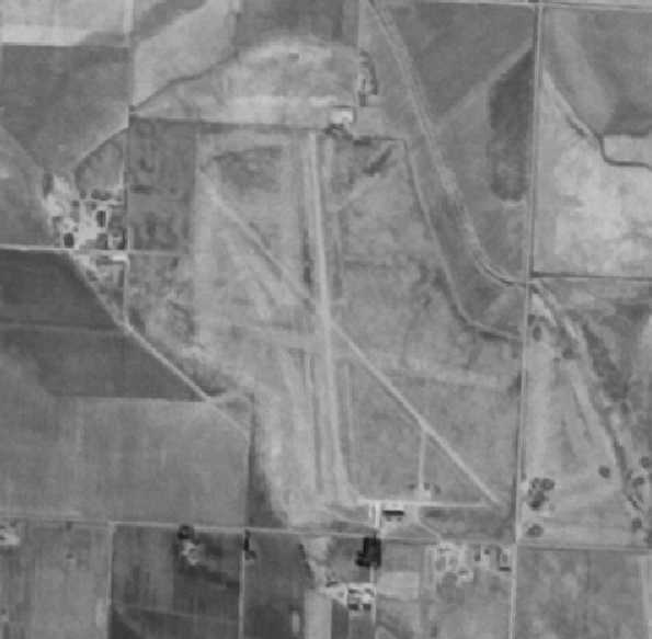
As seen in the northwest corner of the 1991 USGS aerial photo, the outline of at least 2 of the former runways
were still recognizable at the site of the original Garden City Municipal Airport.
None of the buildings on the eastern portion of the site seemed to date from the airport days, though,
as none of them seemed to match the layout of the buildings from the 1949 airport directory.
A 2014 aerial photo showed the faint diagonal outlines of 2 former runways
were still recognizable on the northwest portion of the site of the original Garden City Municipal Airport.
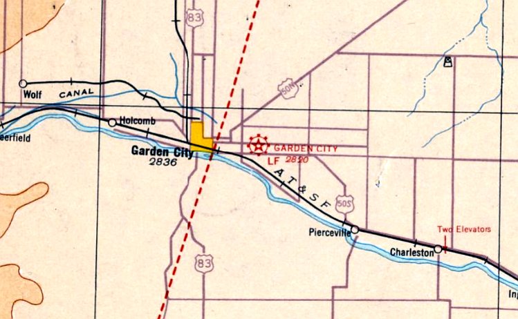
The site of the original Garden City Municipal Airport is located northwest of the intersection of Route 50 & North Farmland Road.
____________________________________________________
Garden City Aux Army Airfield #1 / Ingalls Municipal Airport (30K), Ingalls, KS
37.91, -100.53 (West of Wichita, KS)
The earliest depiction which has been located of “Garden City Army Air Field Auxiliary #1”
was a 10/6/43 aerial view looking north from the 1945 AAF Airfield Directory (courtesy of Scott Murdock).
Garden City Auxiliary #1 was not yet depicted on the September 1942 Wichita Sectional Chart.
According to an Army Corps of Engineers report, Garden City Auxiliary Field #1 was constructed in the 1943
as one of 3 auxiliary landing fields for the basic flying school located at Garden City AAF (12 miles west).
The site consisted of a total of 640 acres, on which the Army constructed concrete runways,
taxiways, parking area, a control tower & other buildings.
Brian Rehwinkel noted, “A base history document says the grading & paving for this field required about $1,700,000.”
A 5/15/43 AAF list of airfields of the Gulf Coast Training Center (courtesy of Ron Plante)
described Garden City Auxiliary #1 as having 3 concrete runways, with the longest being two 3,000' north/south strips.
The earliest depiction which has been located of “Garden City Army Air Field Auxiliary #1”
was a 10/6/43 aerial view looking north from the 1945 AAF Airfield Directory (courtesy of Scott Murdock).
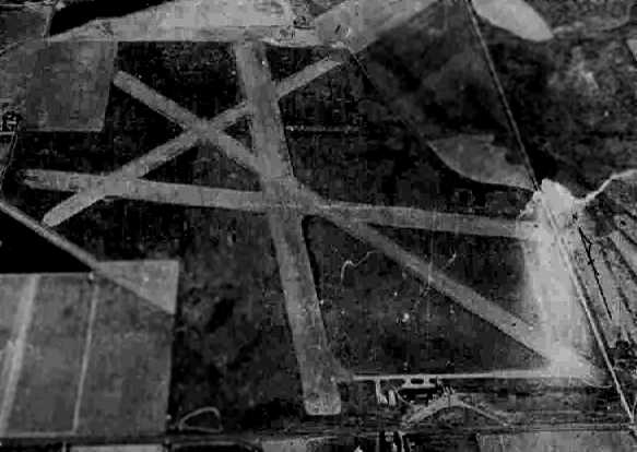
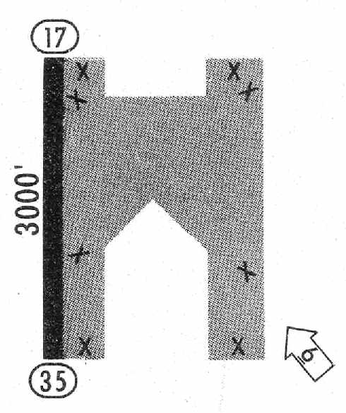
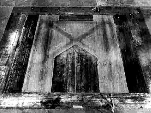
It depicted the field as having a very unusual configuration: 2 parallel north/south concrete runways
joined by a concrete parking area in the center, forming an “M” shape.
A few small buildings were visible on the south side of the field.
Garden City AAF Aux #1 was described by the 1944 US Army/Navy Directory of Airfields (courtesy of Ken Mercer) as having a 3,000' hard-surface runway,
which the remarks described as a "3,000' x 2,200' bituminous landing mat."
The earliest aeronautical chart depiction of Garden City Auxiliary Field #1 which has been located
was on the February 1944 Wichita Sectional Chart (courtesy of Chris Kennedy).
It depicted Garden City Aux “#1” along with Garden City AAF & its other auxiliary airfields.
"Garden City AAF (Aux)" & all 3 of its auxiliary airfields were still depicted
as military airfields on the 1945 Wichita Sectional Chart (courtesy of Chris Kennedy).
The 1945 AAF Airfield Directory (courtesy of Scott Murdock) described “Garden City Army Air Field Auxiliary #1”
as a 626 acre square property on which was situated a 3,000' x 2,200' concrete landing mat.
The field was said to not have any hangars, to owned by the U.S. Government, and operated by the Army Air Forces.
Garden City Aux #1 was declared excess in 1945, and the site was conveyed to the City of Ingalls in 1948.

"Ingalls Municipal Airport", as depicted in the 1949 KS Airport Directory (courtesy of Chris Kennedy).
The 1949 KS Airport Directory (courtesy of Chris Kennedy)
depicted Ingalls Municipal Airport as having a bituminous landing mat in an "M" shape, measuring 3,000' x 2,200'.
A total of 4 buildings (hangars?) were situated at the southeast corner of the field.
The airport was not attended and the operator was listed as the Mayor of Ingalls.
"Ingalls" was depicted on the October 1963 Sangre De Christo Mountains World Aeronautical Chart (courtesy of Donald Felton)
as having a 3,000' hard-surface runway.
The 1965 Jeppesen Manual (courtesy of Chris Kennedy) depicted Ingalls Airport as having a 3,000' paved Runway 17/35, along with multiple closed runways.
The manager was listed as George Johnson.
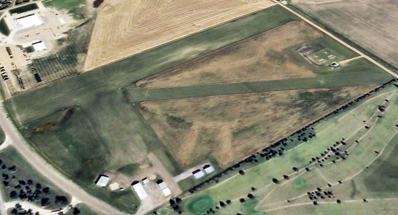
A 3/6/65 USGS aerial photo showed Garden City Aux #2's unusual M-shaped airfield remained in fine condition.
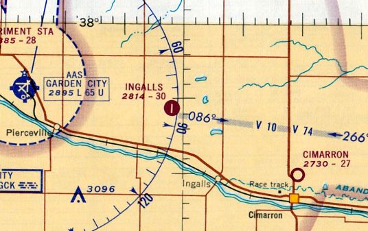
The last aeronautical chart depiction which has been located of Ingalls Airport was on the June 1965 Wichita Sectional Chart (courtesy of Ron Kunse).
It depicted Ingalls Airport as having a 3,000' paved north/south runway.
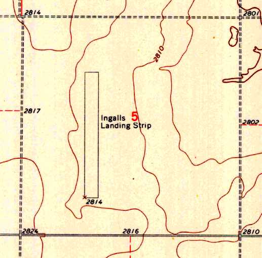
Strangely, the 1968 USGS topo map depicted “Ingalls Landing Strip” as having only a single north/south paved runway,
but did not depict at all the majority of the surrounding paved surface.
A 1995 USGS aerial photo showed the Garden City Aux #1 Airfield remained completely intact.
A narrow portion of the western runway was marked as Runway 17/35,
and a (post-WW2) hangar was located just southwest of the center of the airfield.
As of 2004 the airfield was known as Ingalls Municipal Airport, and was being (barely) used as a landing strip for a crop dusting operation.
The field was listed as being home to 3 single-engine aircraft.
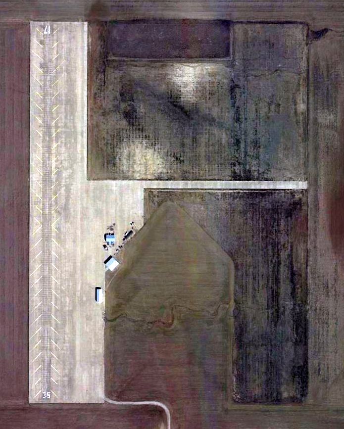
A 3/16/12 aerial photo showed Ingall's western runway 17/35 had recently been repaved, along with a narrow crosswind runway.
See also: http://www.hnd.usace.army.mil/OEW/factshts/factshts/gc021000.htm
____________________________________________________
Garden City Aux Army Airfield #2, Garden City, KS
38, -100.63 (West of Wichita, KS)
The earliest depiction which has been located of “Garden City Army Air Field Auxiliary #2”
was a 10/6/43 aerial view looking north from the 1945 AAF Airfield Directory (courtesy of Scott Murdock).
Garden City Auxiliary #2 was not yet depicted on the September 1942 Wichita Sectional Chart.
According to a 1995 Army Corps of Engineers Report, the Army purchased 356 acres at this site in 1943,
to be used as one of 3 auxiliary airfields to support the basic flying school at the Garden City Army Air Field (located to the southwest).
"The field consisted of nothing more than bituminous surface landing area & fencing."
A 5/15/43 AAF list of airfields of the Gulf Coast Training Center (courtesy of Ron Plante)
described Garden City Auxiliary #2 as having 3 asphalt runways, with the longest being two 3,000' north/south strips.
The earliest depiction which has been located of “Garden City Army Air Field Auxiliary #2”
was a 10/6/43 aerial view looking north from the 1945 AAF Airfield Directory (courtesy of Scott Murdock).
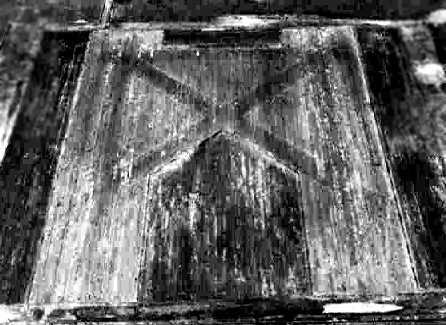
It depicted the field as having an “M”-shaped paved landing mat on which were a total of 5 runways.
There were no buildings visible at the airfield.
Garden City AAF Aux #2 was described by the 1944 US Army/Navy Directory of Airfields (courtesy of Ken Mercer)
as having a 3,000' x 2,200' bituminous landing mat.
The earliest aeronautical chart depiction of Garden City Auxiliary Field #2 which has been located
was on the February 1944 Wichita Sectional Chart (courtesy of Chris Kennedy).
It depicted Garden City Aux “#2” along with Garden City AAF & its other auxiliary airfields.
Garden City Aux #2 was still depicted as an active airfield on the 1945 Wichita Sectional Chart (courtesy of Chris Kennedy).
The 1945 AAF Airfield Directory (courtesy of Scott Murdock) described “Garden City Army Air Field Auxiliary #2”
as a 357 acre square property on which was situated a 3,000' x 2,200' bituminous all-way landing area.
The field was said to not have any hangars, to owned by the U.S. Government, and operated by the Army Air Forces.
According to the 1995 Army report, the #2 Auxiliary Field was declared excess in 1945.
Garden City Aux #2 was apparently never reused as a civil airfield,
as it was no longer depicted on the September 1947 Wichita Sectional Chart.
According to the 1995 Army report, Garden City Aux #2 was conveyed by quitclaim deed to private individuals in 1948.
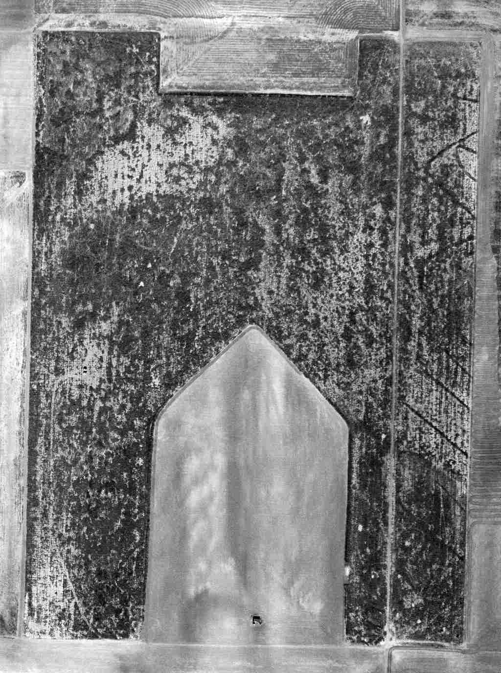
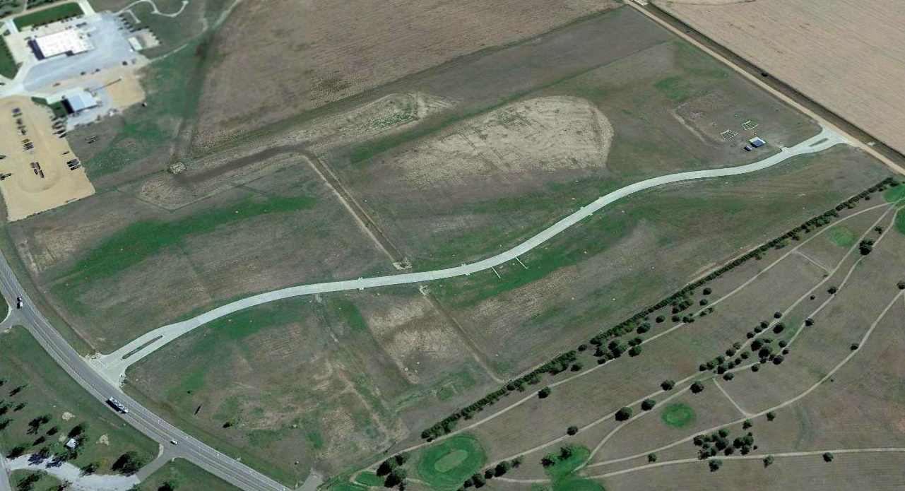
A 3/6/65 USGS aerial photo showed the recognizable outline of Garden City Aux #2's unusual M-shaped airfield configuration.
Garden City Aux #2 was not depicted at all on USGS topo maps from 1975, 1978, or 1991.
According to the 1995 Army report, "The site has since been converted to cultivated fields with only minor evidence of broken-up concrete on the site."
A 2017 aerial view looking north showed the recognizable outline of Garden City Aux #2's unusual M-shaped airfield configuration.
Garden City Aux #2 is located southwest of the intersection of East Gray County Line Road & Route 27.
Thanks to Chris Kennedy for pointing out this airfield.
___________________________________________________
Garden City Aux Army Airfield #3, Garden City, KS
38, -100.77 (West of Wichita, KS)
The earliest depiction which has been located of “Garden City Army Air Field Auxiliary #3”
was a 10/6/43 aerial view looking north from the 1945 AAF Airfield Directory (courtesy of Scott Murdock).
Garden City Auxiliary #3 was not yet depicted on the September 1942 Wichita Sectional Chart.
According to a 1995 Army Corps of Engineers Report,
the Army purchased & obtained easements for a total of 297 acres at this site in 1943,
to be used as one of 3 auxiliary airfields to support the basic flying school
at the Garden City Army Air Field (located to the southeast).
"The Army constructed asphalt roads, concrete runways, wood frame buildings, and fencing."
A 5/15/43 AAF list of airfields of the Gulf Coast Training Center (courtesy of Ron Plante)
described Garden City Auxiliary #3 as having 3 asphalt runways, with the longest being two 3,000' north/south strips.
The earliest depiction which has been located of “Garden City Army Air Field Auxiliary #3”
was a 10/6/43 aerial view looking north from the 1945 AAF Airfield Directory (courtesy of Scott Murdock).
It depicted the field as having an “M”-shaped paved landing mat on which were a total of 5 runways.
There were no buildings visible at the airfield.
Garden City AAF Aux #3 was described by the 1944 US Army/Navy Directory of Airfields (courtesy of Ken Mercer)
as having a 3,000' x 2,200' bituminous landing mat.
The earliest aeronautical chart depiction of Garden City Auxiliary Field #3 which has been located
was on the February 1944 Wichita Sectional Chart (courtesy of Chris Kennedy).
It depicted Garden City Aux “#3” along with Garden City AAF & its other auxiliary airfields.
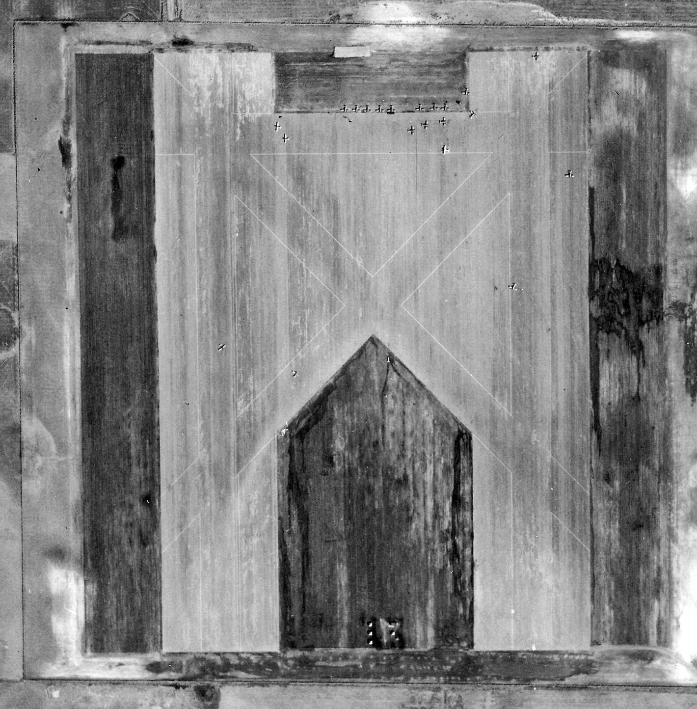
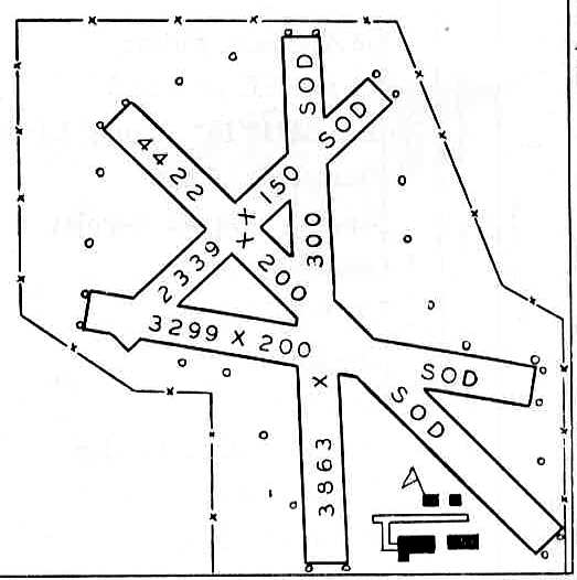
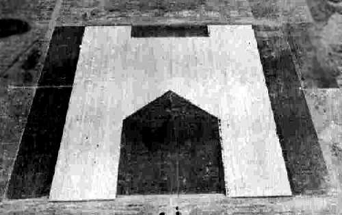
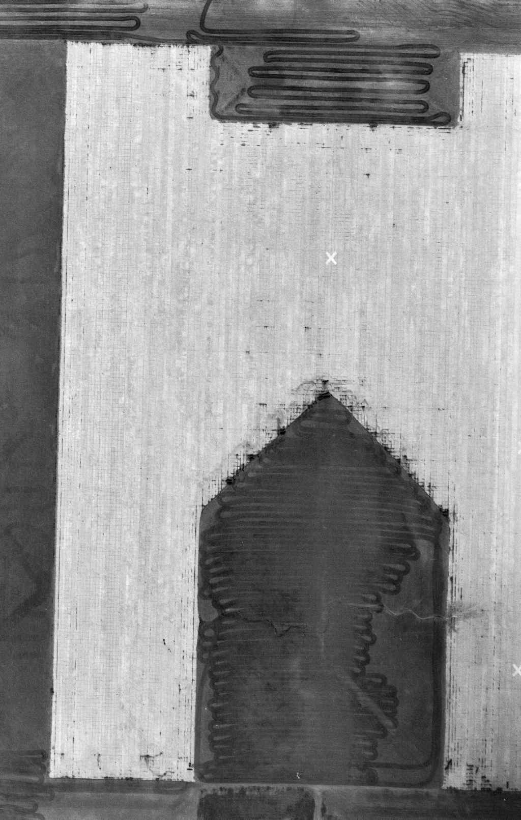
The only photo which has been located showing planes at Garden City Auxiliary Field #3 was a 3/27/44 USAAF aerial view from the Air Force Historical Research Agency (courtesy of Brian Rehwinkel).
Brian Rehwinkel noted, “This field was very busy on 3/27/44. There are no fewer than 21 planes on the landing mat, and one plane in on short final at the top left portion of the photo.
You can also see a number of hutments & another small building near the south end of the field. I believe this field also has a small crash truck building.
This unusual field design fascinates me to no end (I only know of one other AAF – Pecos AAF in TX – that has an auxiliary field shaped like this).
The shape of the field allows use by multiple planes simultaneously. The layout allowed at least 4 runways of approximately 3,000' each.
However, these small fields were expensive for their time. A base history document says this field coast over $815,000 to purchase, grade, and pave.
The grading and paving alone cost about $800,000. I believe the asphalt paving covered an area of about 650,000 yards
(although the grading & paving cost for this field was significantly less than that for Auxiliary Field # 1).”
Garden City Aux #3 was still depicted as an active airfield on the 1945 Wichita Sectional Chart (courtesy of Chris Kennedy).
The 1945 AAF Airfield Directory (courtesy of Scott Murdock) described “Garden City Army Air Field Auxiliary #3”
as a 270 acre square property on which was situated a 3,000' x 2,200' bituminous all-way landing area.
The field was said to not have any hangars, to owned by the U.S. Government, and operated by the Army Air Forces.
According to the 1995 Army report, the auxiliary field was declared surplus in 1945,
and the site was conveyed by quitclaim deed to private individuals in 1947.
Garden City Aux #3 was apparently never reused as a civil airfield,
as it was not depicted at all on the March 1949 Wichita Sectional Chart (courtesy of Chris Kennedy).
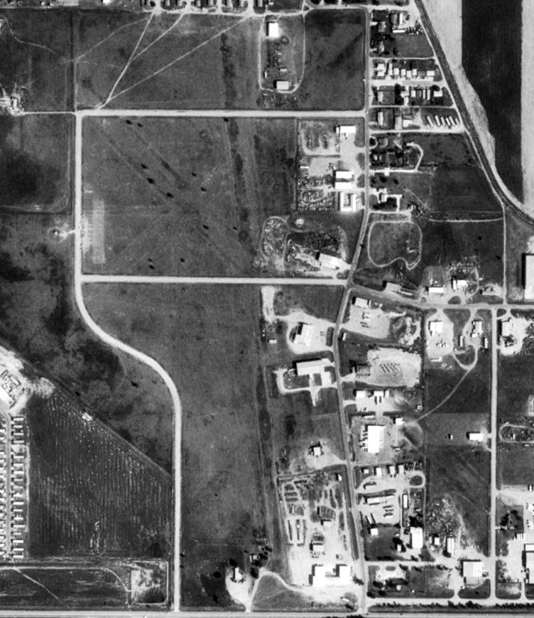
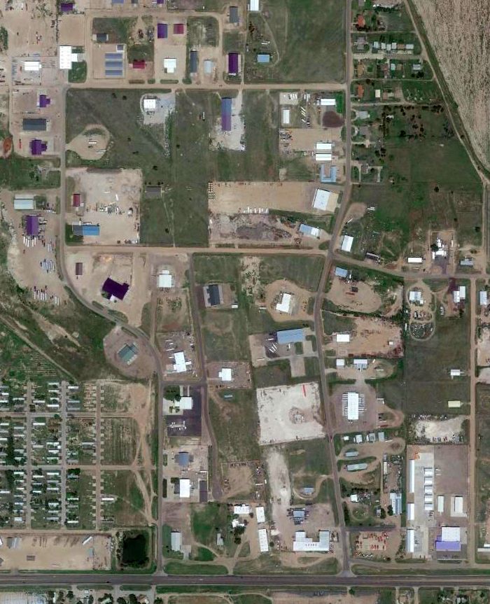
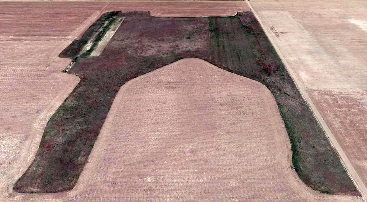
It was labeled "feedlot" on the 1978 & 1991 USGS topo maps.
A 1991 USGS aerial photo showed the site of Garden City Aux #3 had been reused as a cattle feedlot.
Unlike the other 2 Garden City Auxiliary Airfields, the once-distinctive runway layout was no longer recognizable.
According to the 1995 Army report, "The site is presently being used for cropland & a feed lot.
None of the original structures or site improvements remain. There are only remnants of the runway to mark the facility location."
A 2023 aerial photo looking north showed the site of Garden City Aux #3 had been reused as a cattle feedlot.
Unlike the other 2 Garden City Auxiliary Airfields, the once-distinctive runway layout was no longer recognizable.
Garden City Aux #3 is located northwest of the intersection of East Mary Street & North 16 Mile Road.
Thanks to Chris Kennedy for pointing out this airfield.
____________________________________________________
<
Or if you prefer to contact me directly concerning a contribution (for a mailing address to send a check),
please contact me at: paulandterryfreeman@gmail.com
If you enjoy this web site, please support it with a financial contribution.
____________________________________________________
This site covers airfields in all 50 states.