Abandoned & Little-Known Airfields:
Southeastern Idaho
© 2002, © 2025 by Paul Freeman. Revised 8/15/25.
This site covers airfields in all 50 states: Click here for the site's main menu.
____________________________________________________
Please consider a financial contribution to support the continued growth & operation of this site.
Gimlet Airport (revised 10/29/23) - Hayfield Airport (revised 8/15/25) - Pocatello Municipal Airport / McDougall Field (revised 6/29/19)
Test Area North (revised 5/27/13) - University Field / Ham's Field (revised 9/15/21)
____________________________________________________
Gimlet Airport, Sun Valley, ID
43.622, -114.345 (East of Boise, ID)
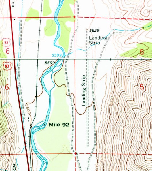
Gimlet Airport, as depicted on the 1967 UGS topo map.
This small general aviation airport may have been established at some point between 1966-67,
as it was not yet depicted on a 1966 USGS aerial photo.
Gimlet Airport was not yet depicted on the May 1967 Boise Sectional Chart.
The earliest depiction which has been located of Gimlet Airport was on the 1967 USGS topo map.
It depicted a north/south unpaved runway, generically labeled as “Landing Strip”.
There were no buildings or other airfield features depicted.
Wayne Werner recalled, “Pete Johnson of Johnson Flying Service started at the Hailey Airport & moved to the Gimlet property likely in the 1960s.
He didn't like the bureaucracy of the Hailey Airport.”
The earliest aeronautical chart depiction which has been located of Gimlet Airport was on the May 1969 Boise Sectional Chart.
It depicted Gimlet as a private airfield having a north/south paved 4,700' runway.
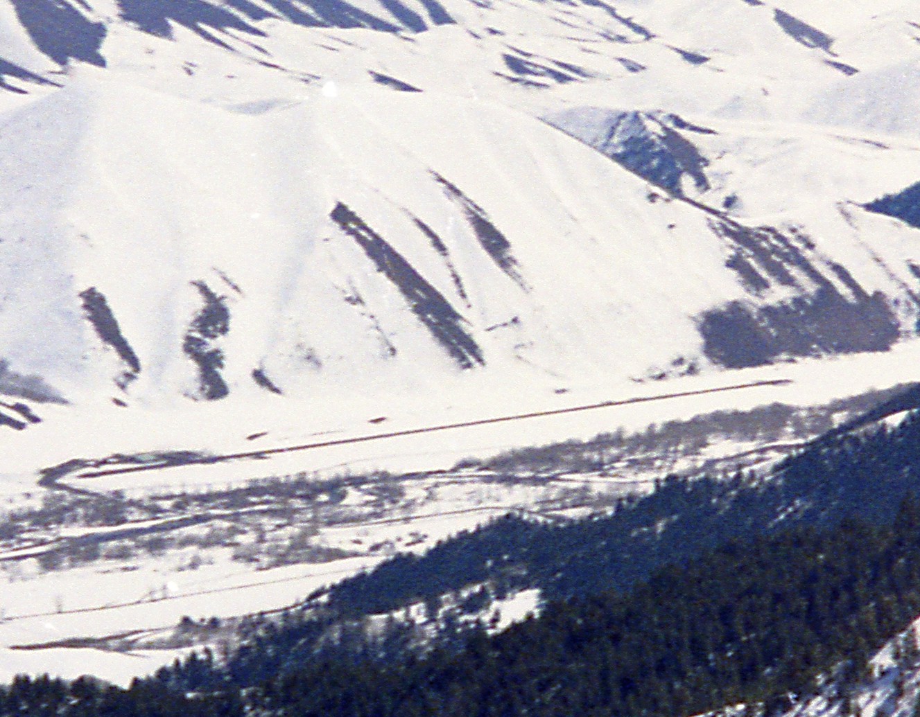
A January 1970 photo (courtesy of Adam Kohne) looking northwest at Gimlet Airport, showing a north/south runway at the base of a steep valley.
The last aeronautical chart depiction which has been located of Gimlet Airport was on the May 1971 Boise Sectional Chart (courtesy of Ron Plante).
It depicted Gimlet as a private airfield having a single northwest/southeast paved 4,800' runway.
Wayne Werner recalled, “Pete Johnson operated the Gimlet Airport until his death in 1975.
His wife operated the airport until 1977 & sold the property to Wally Wright around 1980, when it was then sold off as lots for home development."
Gimlet Airport was still depicted on the 1982 USGS topo map, as “Landing Strip”.
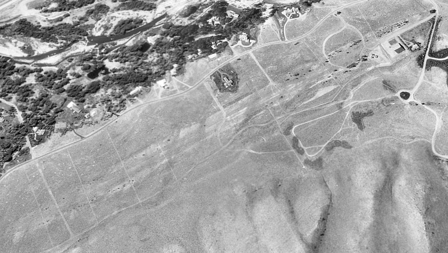
A 1992 USGS aerial view looking northwest showed only faint traces of the Gimlet Airport runway, but the one hangar remained on the north side (top-right).
Gimlet Airport was no longer depicted on the November 1993 Salt Lake Sectional Chart (courtesy of Ron Plante).
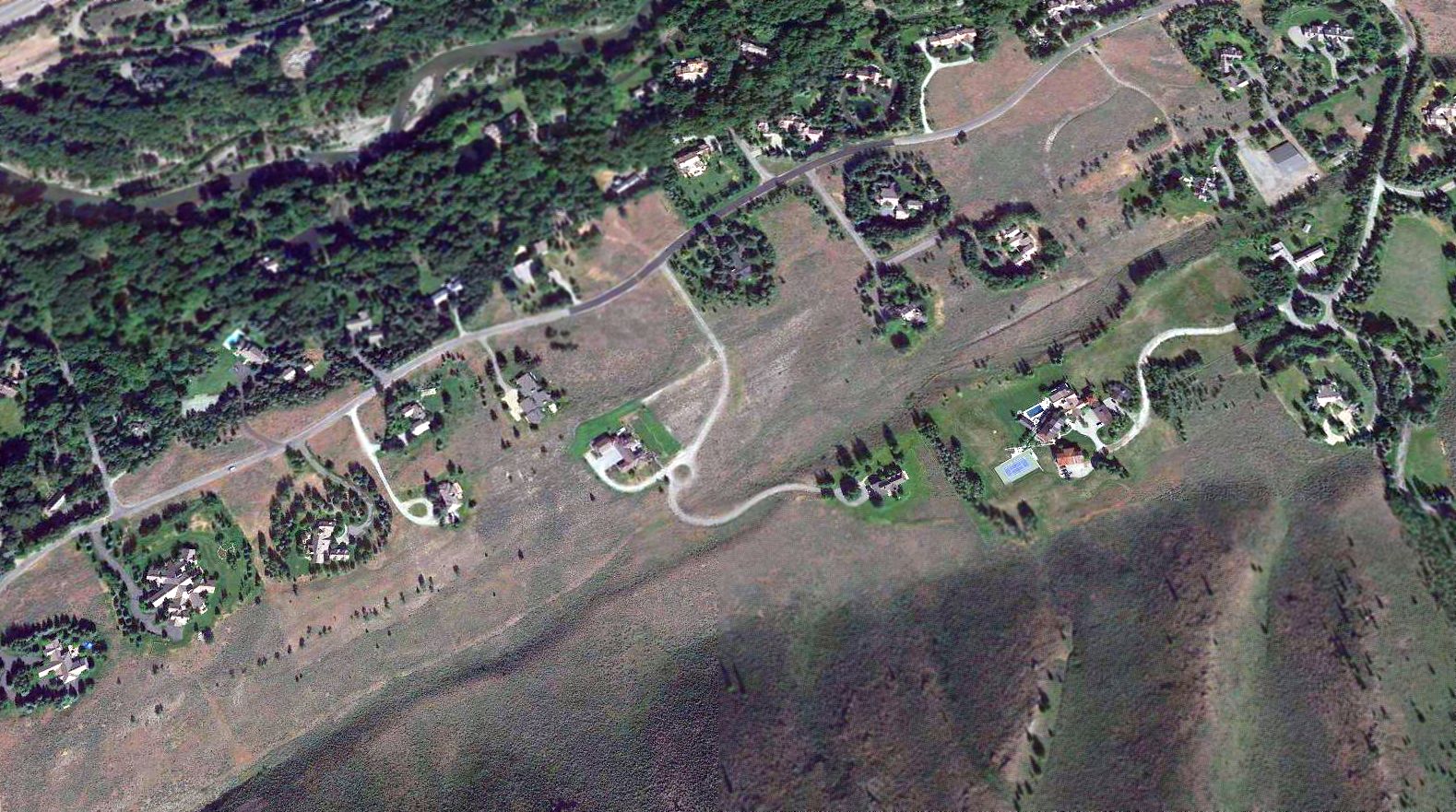
A 2016 aerial view looking northwest showed only faint traces remained of Gimlet Airport's runway, with several houses having been built over it, but the one hangar remained on the north side (top-right).
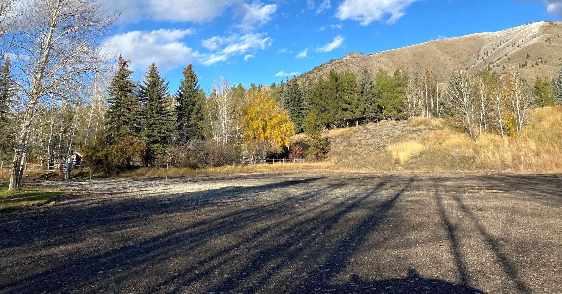
A 10/26/23 photo of the site of the Gimlet Airport hangar by Matt Franklin, who reported “It looks like the hangar that remained for 40+ years after closure has been pulverized for another home lot; I think I missed it pretty recently.”
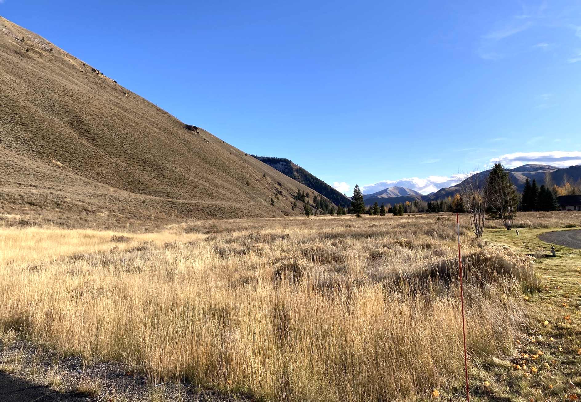
A 10/26/23 photo of the site of the Gimlet Airport runway by Matt Franklin, “indistinguishable from nature.”
The site of Gimlet Airport is located at the southern terminus of Hanger Road (which is apparently misspelled, as a “hanger” holds clothes, whereas a “hangar” holds an airplane).
____________________________________________________
Test Area North, Monteview, ID
43.86, -112.73 (East of Boise, ID)
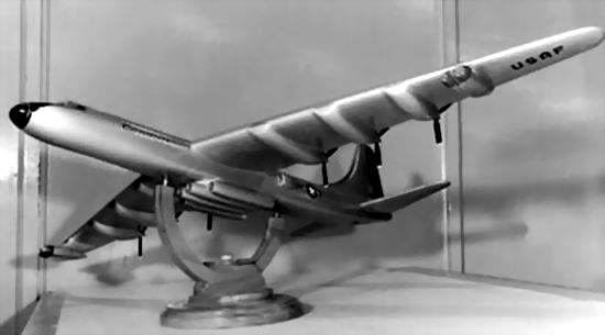
A concept for a nuclear-powered X-6, derived from the Convair B-36.
![]()
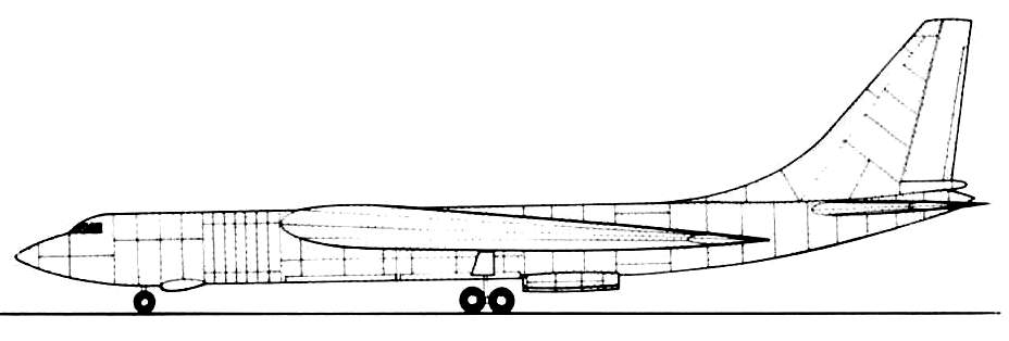
A Northrop concept for a nuclear propelled bomber, refueling two other aircraft.
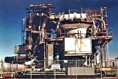
The HTRE-3 nuclear aircraft engine, without its test structure.
This is a rather unique case of where an extremely substantial hangar was built,
but never the accompanying runway!
The National Reactor Testing Station (known today as the Idaho National Engineering & Environmental Laboratory)
was established in 1949 in a very remote part of Idaho.
Test Area North was constructed in the early 1950s at the north end of the NRTS property,
about 27 miles northeast of the Central Facilities Area.
It was built by the USAF & the Atomic Energy Commission to support the Aircraft Nuclear Propulsion Program,
an attempt to develop a nuclear propelled bomber.
Beginning in 1955, TAN was the site of the Heat Transfer Reactor Experiments (HTRE),
which conducted ground-based testing of what was intended to be the prototype aircraft nuclear engine.
The aircraft which was intended to use this powerplant was the Convair X-6.
The X-6 was originally intended to be based on Convair's B-36 bomber,
but the design was later changed to use Convair's B-60 (the swept-wing development of the B-36) as its baseline.
The X-6 was intended to have conducted its flights from Test Area North.
A huge (350' wide) hangar to house the X-6 was constructed at Test Area North, built with enormously thick, nuclear-shielded walls & bays.
The hangar was reportedly the largest in the state of ID.
General Electric, the program contractor, planned to equip the engine maintenance facilities with closed-circuit television systems
and remote manipulator arms to allow technicians to work on the aircraft & its powerplant
without direct exposure to the intense radiation field that would persist even after the reactor was shut down.
Since the turbojets essentially functioned as the cooling system for the reactor,
they would have to be run at high power settings even after shutdown of the reactor
in order to maintain cooling airflow through the still-hot core.
After an initial cooldown period, ground cooling systems would be connected to the reactor
and the engines could be shut down as the reactor was extracted from the airplane & placed in its shielded storage bay.
It was estimated that the tremendous weight of a nuclear propelled X-6 would have necessitated a 15,000' runway.
Plans for such a runway were drawn up at TAN, extending to the southwest away from the hangar area, but the runway was never constructed.
A multi-mile runway for the X-6 was also planned at Edwards AFB, CA,
running between Muroc dry lake & Rosamond dry lake, but it too was never built (see Pancho Barnes Airfield, CA).
The initial HTRE engine experiments were intended to prove out the engineering & operational concepts
for a nuclear bomber powerplant, but without the restrictions on weight & size that an airplane powerplant would demand.
These early assemblies were gigantic monstrosities weighing at least a hundred thousand pounds,
and were built on railcars which would move them to remote test locations
far from their assembly, maintenance & control facilities.
When the engineering aspects of the designs were proven,
the next step would be to reduce the size of the designs while increasing their power output,
with the goal of producing a final, operational version of the design
that would be "flightweight" & "flightsize", with a thermal output of at least 50 megawatts.
This was to be done in stages over a several year period.
Several non-flightworthy prototype nuclear aircraft engines were actually tested at the Initial Engine Test Area,
located at the north end of Test Area North.
HTRE-1, also known as the Core Test Facility, the initial aircraft engine/reactor testbed,
was mounted on a huge mobile railroad car assembly.
It was a water-moderated uranium reactor with a beryllium reflector & shielding that included large quantities of mercury.
The two jet engines just visible at lower left would be started using hot gas produced by chemical-fuel combustors.
Once the jets were running at speed, the reactor would be brought up to power & airflow would be established through the core.
Its heat would then be gradually diverted to the jet turbines as the gas combustor flow was phased out.
The jets would be run on nuclear-heated air for periods of hours at a time
to simulate the operation of a long-duration nuclear aircraft powerplant.
Post-shutdown, the reactor's railcar would be returned to a maintenance bay for disassembly & analysis.
HTRE-1 reached power levels as high as 20.2 megawatts.
General Electric began HTRE-1 test runs in 1955
and the reactor successfully powered the X39 engines the following year,
although the massive contraption was far from a practical aircraft powerplant.
However, HTRE-3 was a major step toward a flight-capable nuclear engine,
which would have been designated XNJ140E-1.
The dimensions of the core & its structural characteristics as well as the design temperatures
were those of a power plant capable of providing useful flight propulsion.
The power generated by HTRE-3 ranged up to 35 megawatts.
In the HTRE No. 3 tests, the power levels were so chosen that the fuel element temperatures, the key parameter,
would be characteristic of flight service.
The size & configuration of HTRE-3 appear to have been designed with the B-36 or B-60 in mind.
HTRE-3 was operated at the National Reactor Testing Station from 1958-60.
Although no aircraft was ever operated under nuclear propulsion,
an NB-36 testbed did fly while carrying an operating nuclear reactor.
These flights were not carried out from TAN, tough.
Having successfully operated a 35 megawatt, flightweight nuclear turbojet powerplant
that probably could have propelled a bomber-sized aircraft,
the Aircraft Nuclear Propulsion project came rather close to fulfilling the original design goals of the late 1940s.
If HTRE-3 had existed in 1952, it most likely would have flown in an aircraft,
but by 1961 the very existence of manned bombers was threatened by the cheaper, faster & relatively invulnerable ICBM.
The large nuclear airplane engine had lost its raison d'etre in the Kennedy/McNamara era,
and the ANP program was canceled in 1961.
The Initial Engine Test area is located at the north end of Test Area North.
After the Aircraft Nuclear Propulsion program ended in 1961,
the area was used for the Space Nuclear Auxiliary Power Transient Program through 1967.
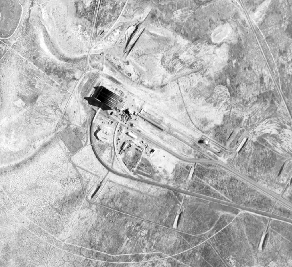
A 7/11/67 USGS aerial photo showed the former X-6 hangar, and surrounding revetments for testing.
No sign of any accompanying runway was present in photos of the surrounding area.
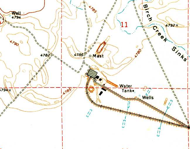
The 1969 USGS topo map depicted the Test Area North hangar, but no other airfield-related facilities.
Doug Brinkman recalled, “I used to work at Test Area North in the 1980s.
I have been inside of & stood atop the hangar, and the white dome. When I was there it was called LOFT.”
The Three Mile Island Unit 2 reactor core was shipped to the INEEL's Spent Fuel Program area in 1986.
The Contained Test Facility is located at the west end of Test Area North.
This facility includes the Containment & Service Building (reactor facility),
the aircraft hangar, the Reactor Control & Equipment Building, and numerous support facilities.
Preparation for deactivation of these buildings & structures began in 1996,
and included documentation of some of the historic properties, including the Nuclear Aircraft Hangar.
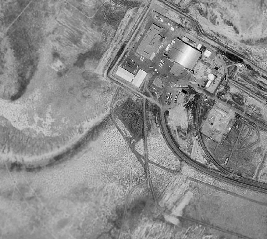
The former X-6 hangar is visible in the top-right of the 1998 USGS aerial photo.
No sign of any accompanying runway is present in photos of the surrounding area.
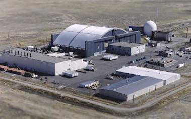
Today, Test Area North is composed of 4 areas: the Contained Test Facility, the Technical Support Facility,
the Water Reactor Research Test Facility, and the Initial Engine Test area.
Currently, the Initial Engine Test facility is being demolished.
According to INEEL's website, "Unless it becomes necessary for the US to resume former levels of defense-related activities,
the future of Test Area North will consist of completing current programs,
deactivating all facilities, and completing environmental restoration activities."
The former X-6 hangar was still visible in a 6/24/09 aerial photo.
See also:
http://www.ufx.org/nepa/nepa2.htm
http://titanic.inel.gov:1025/plan/cflup/html/tan.htm
____________________________________________________
42.93, -112.45 (North of Pocatello, ID)
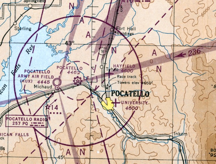
Hayfield Airport, as depicted on the November 1946 Pocatello Sectional Chart).
Photo of the airport while open has not been located.
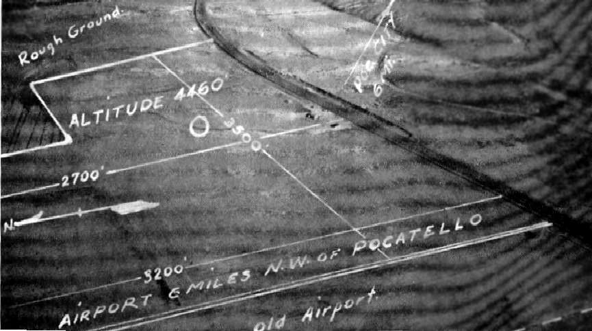
According to Robert Pearson, "Hayfield Airport was built in the late 1930s."
However, the airport's opening may have been somewhat later (or it may have been just overlooked for a while),
as it was not listed in several airport references from 1937-1945,
including the Airport Directory Company's 1937 Airport Directory (courtesy of Bob Rambo),
the 1937 or 1944 USGS topo maps, the April 1944 US Army/Navy Directory of Airfields (courtesy of Ken Mercer),
and the July 1941 Pocatello Sectional Chart or February 1945 Pocatello Sectional Chart.
The earliest depiction of Hayfield which has been located was on the November 1946 Pocatello Sectional Chart,
which depicted Hayfield as an auxiliary airfield.
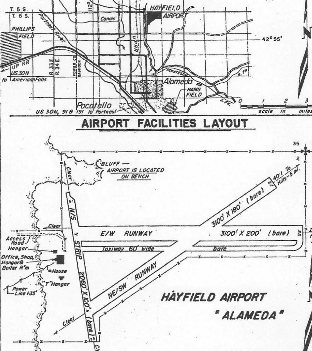
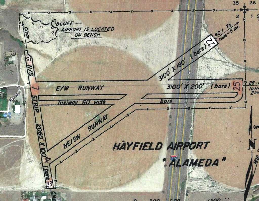
According to Robert Pearson, "The turf runway was about 2,000' long & ran north/south.
The people who I met at the site told me that the field's owner had trained many returning GIs how to fly using the GI bill.
A private VFR license cost $150 in the late 1940s."
The last aeronautical chart depiction which has been located of Hayfield was on the April 1949 Pocatello Sectional Chart.
It depicted Hayfield as having a 3,100' unpaved runway.
The 1950 ID Airport Directory (courtesy of Robert McLaughlin)
depicted Hayfield as having 3 bare runways, with the longest being the 3,100' east/west & northeast/southwest strips.
An office, hangar, and T-hangar were located on the west side.
The operator was listed as Aviation Corporation, and the manager as Maynard Craig.
According to Robert Pearson, "Hayfield Airport shut down in 1952 when the Pocatello Airbase became the city airport.
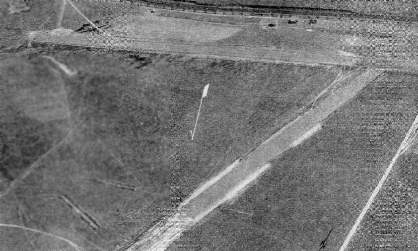
A 1969 USGS aerial view showed that Interstate 15 had been built through the eastern portion of the airport site,
though a hangar remained standing on the western portion.
Haysfield was no longer depicted on the 1971 USGS topo map.
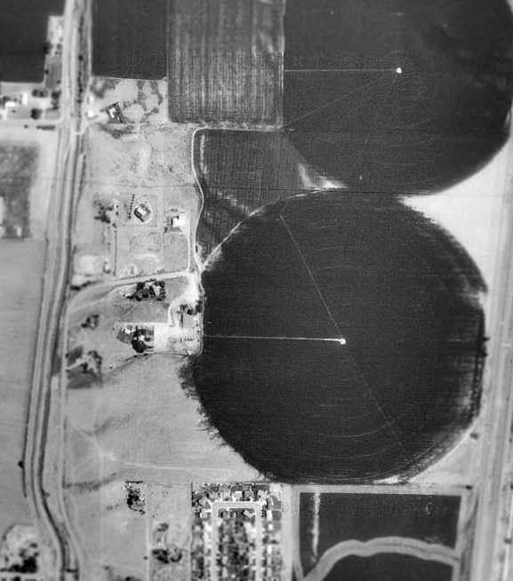
As seen in the 1992 USGS aerial photo, the remaining hangar from Hayfield is just to the left of the center of the photo,
with a circular crop field having been built over the area of the former runway.
Not a trace remains of the former runway.
Robert Pearson visited the site of Hayfield in 2004.
He reported, "The runway was just to the east of the hangar in the wheat field.
No trace of the runway is visible. A parking pad is on the hangar's south side."
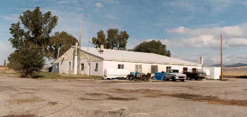
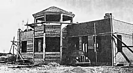
An October 2004 photo by Robert Pearson of the rear of the former Hayfield hangar.
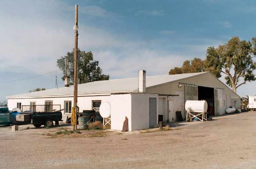
An October 2004 photo by Robert Pearson of the front of the former Hayfield hangar.
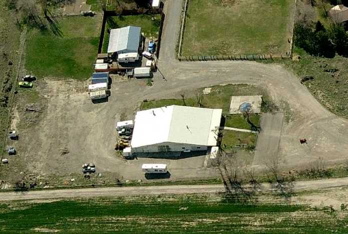
A circa 2005-2010 aerial view looking west at the former Hayfield hangar.
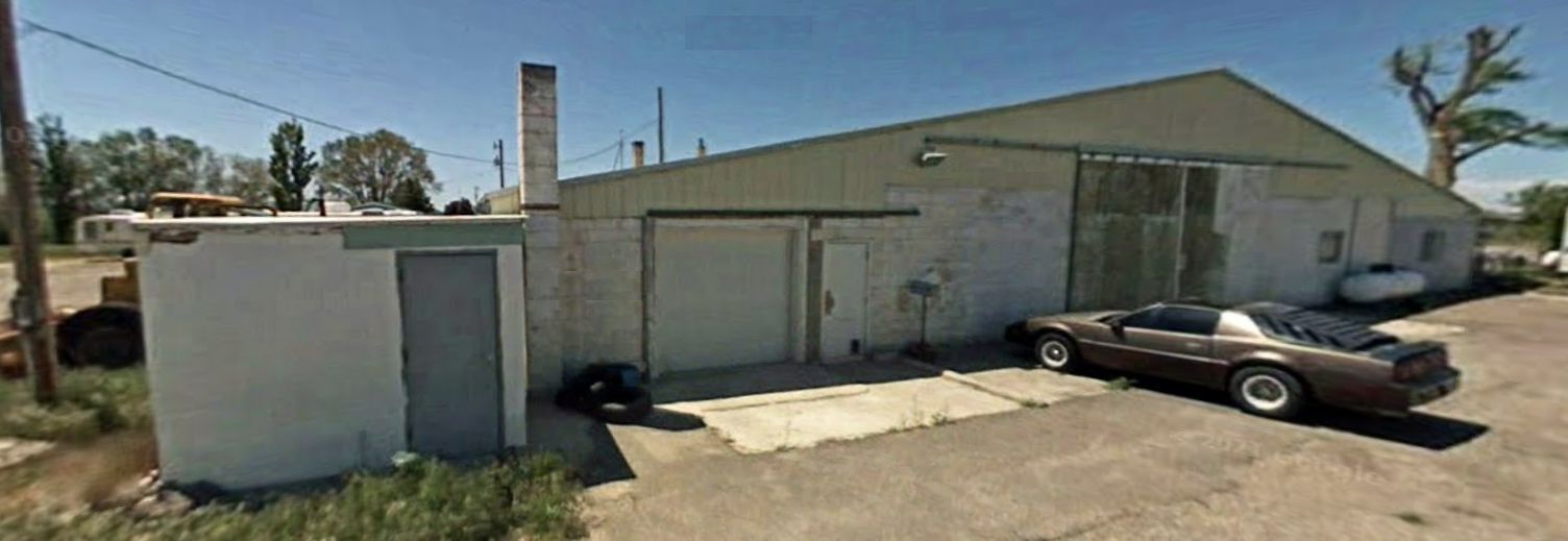
A 2008 photo looking west at the former Hayfield hangar & a beautiful vintage Firebird.
The 1950 ID Airport Directory overlaid by Robert McLaughlin on 2013 aerial view of the site of Hayfield.
The site of Hayfield is located at the northeastern terminus of Buffalo Road, on the eastern side of the Fort Hall Main Canal.
____________________________________________________
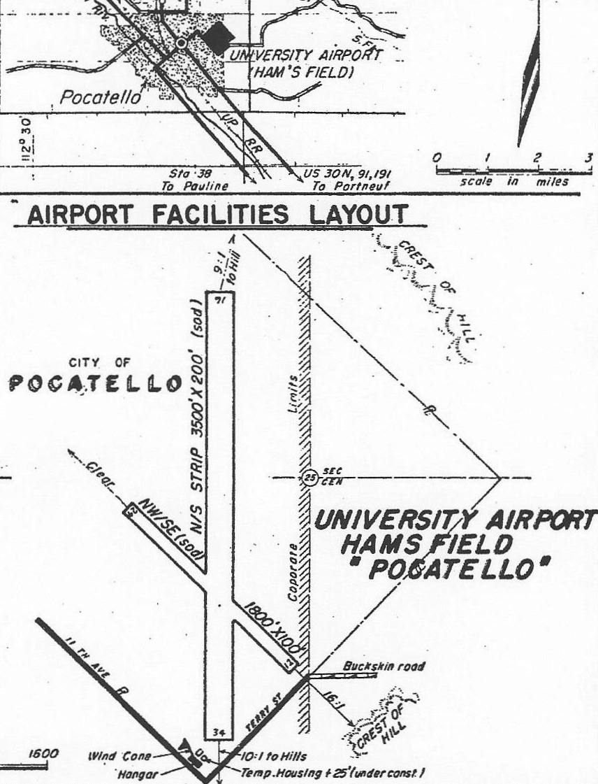
University Field / Ham's Field, Pocatello, ID
42.87, -112.43 (North of Salt Lake City, UT)
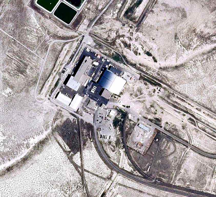
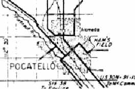
Ham's Field was located on the ground of Idaho State University in Pocatello.
According to Robert Pearson, the school had an aviation division that teaches airframe mechanics since the 1930s.
University Field was not yet depicted on the April 1939 Pocatello Sectional chart.
The aviation school used a turf landing strip that was just northeast of the campus.
Although Ham's Field was not a general aviation airport
it did serve as an air ambulance airport for the adjacent Bannock Memorial Hospital.
The earliest directory listing which has been located of University Field
was in the Airport Directory Company's 1941 Airport Directory (courtesy of Chris Kennedy).
It described University Field as having 3 sod runways, with the longest being the 3,000' north/south strip.
The field was said to have a hangar & emergency fuel.
The earliest aeronautical chart depiction which has been located of University Field was on the July 1941 Pocatello Sectional Chart.
It depicted University Field as an auxiliary airfield.
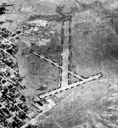
The earliest photo which has been located of University Airport was a 9/3/43 aerial view looking north from the 1945 AAF Airfield Directory (courtesy of Scott Murdock).
It depicted depicted “University Airport (Ham's Field)” as having 3 runways.
The April 1944 US Army/Navy Directory of Airfields (courtesy of Ken Mercer)
described "University (Ham's Field)" as having a 3,500' unpaved runway.
University Field was not depicted at all on the 1944 USGS topo map.
The 1945 AAF Airfield Directory (courtesy of Scott Murdock) described “University Airport (Ham's Field)”
as a 200 acre rectangular property within which were 3 sod runways, the longest being a 3,500' north/south strip.
The field was said to have a single 116' x 63' wood & steel hangar.
University Airport was described as being owned by the State of Idaho, but not currently in operation.
A 1947 photo of Ham's Field (from an ID State College yearbook, via Robert Pearson),
showing the hangar to the right & the turf runway extending away to the top-left.
The last aeronautical chart depiction which has been located of University Airport was on the April 1949 Pocatello Sectional Chart.
It depicted University Airport as having a 3,500' unpaved runway.
The 1950 ID Airport Directory (courtesy of Robert McLaughlin)
depicted University Airport Hams Field as having 2 sod runways, with the longest being the 3,500' Runway 16/34.
A hangar was depicted on the south side.
The operator was listed as ID State College, and the manager as Roy Christensen.
University Field was evidently closed at some point between 1950-54,
as it was no longer depicted at all on the October 1954 Pocatello Sectional chart (according to Chris Kennedy).
According to Robert Pearson, the University's aviation school relocated to the Pocatello Regional Airport,
using Hangar #4 from the its old Army Airfield days.
Ham's Field was still depicted on a location map in the 1964 ID Aviation Facilities Directory (courtesy of Robert Pearson),
even though the airfield had apparently already been closed for a decade at that point.
A 1969 USGS aerial photo showed that a large athletic field house was being built over the site of University Field.
Ham's Field was no longer depicted on the 1971 USGS topo map.
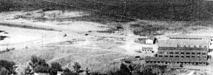
The 1992 USGS aerial photo, overlaid by Robert Pearson with the outline of the former University Field runway.
A large field house has been built over the site of the former runway.
However, a former hangar remains standing at the site.
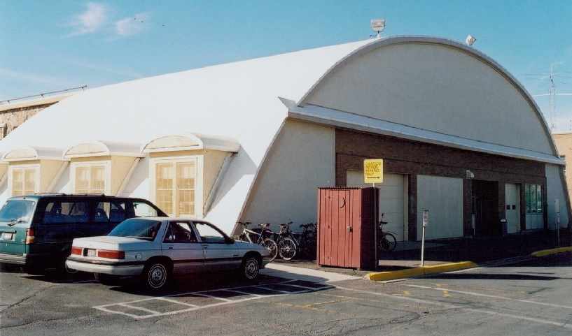
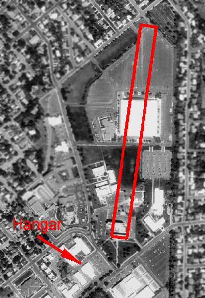
A July 2003 photo by Robert Pearson of the former University Field hangar which remains standing.
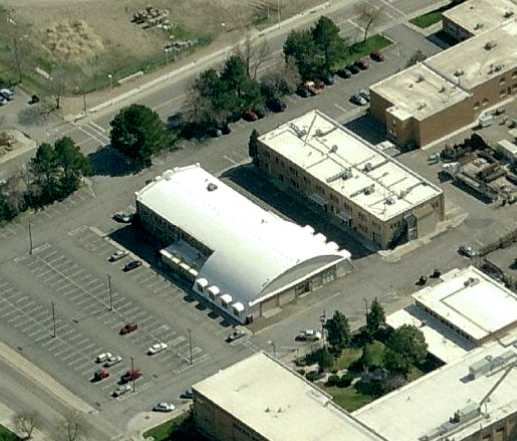
A circa 2005-2010 aerial view looking south at the former University Airport hangar.
The site of Ham's Field is located east of the intersection of Memorial Drive & East Bonneville Street.
____________________________________________________
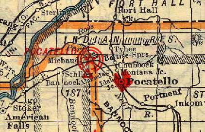
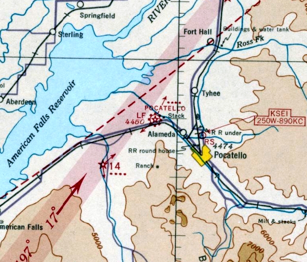
Pocatello Municipal Airport / McDougall Field, Pocatello, ID
42.91, -112.54 (North of Salt Lake City, UT)
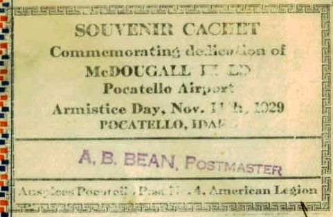
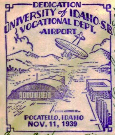
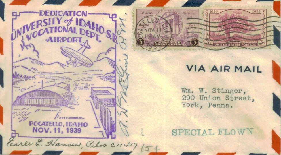
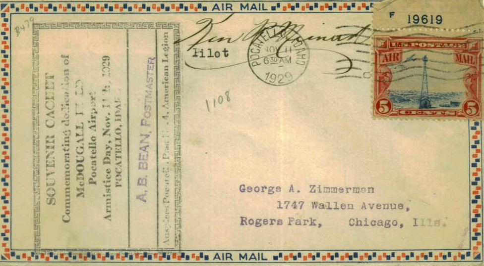
A postmark commemorated the 11/11/29 Dedication of McDougall Field.
The original commercial airport for the town of Pocatello was located less than 2 miles east-southeast
of what would later become the current Pocatello Regional Airport.
According to Robert Pearson, McDougall Field was built in 1928
on a location that was already informally used as an airport.
It was named after Harry Owens McDougall, a WW1 ace who died in an airshow in Pocatello.
A postmark commemorated the 11/11/29 Dedication of McDougall Field.
The earliest depiction which has been located of Pocatello Airport was on a 1930 road map (courtesy of Chris Kennedy).
It described the Pocatello Airport as consisting of a 5,000' x 2,640' rectangular landing area.
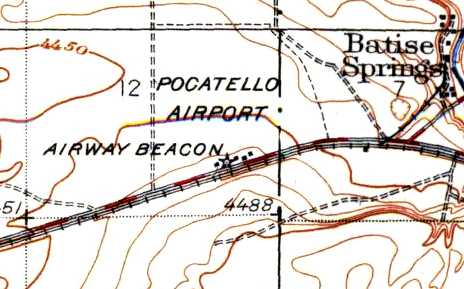
The 1934 USGS topo map depicted the Pocatello Airport as an irregularly-shaped outline,
with several buildings & an Airway Beacon along the south side.
The earliest aeronautical chart depiction which has been located of Pocatello Municipal Airport was on the June 1936 Pocatello Sectional Chart.
An aerial view looking southeast at the "Pocatello Municipal Airport",
from The Airport Directory Company's 1937 Airports Directory (courtesy of Bob Rambo).
It was described as having a sod landing area, measuring 3,500' x 2,700'.
The Pocatello office of the National Weather Service
was located at "Pocatello Municipal Airport, McDougall Field" from 1938-49.
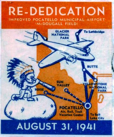
A postmark commemorated the 8/31/41 Re-Dedication of McDougall Field.
An aerial view looking south at the "Pocatello Municipal Airport",
from The Airport Directory Company's 1941 Airports Directory (courtesy of Chris Kennedy).
The field had gained a paved runway at some point between 1937-41,
as it was described as having a 4,300' asphalt east/west runway & a 3,400' "gravelled" north/south runway.
The January 1944 Pocatello Sectional Chart (courtesy of Ron Plante) depicted Pocatello Municipal Airport
as a commercial/municipal airport with a control tower.
The runways at Pocatello were further lengthened by 1944,
as the 1944 US Army/Navy Directory of Airfields (courtesy of Ken Mercer)
described Pocatello Airport as having a 5,400' hard-surface runway.
It also indicated that Army & Navy operations were conducted from the field.
An undated photo of the McDougall terminal building while under construction, courtesy of Robert Pearson.
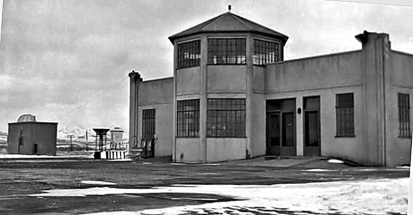
An undated photo of the McDougall terminal building shotly after construction was completed.
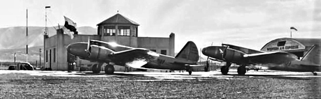
A 12/18/40 photo of 2 Boeing 247s of Western Air Express which had diverted to McDougall because of fog which prevented their landing at Salt Lake City.
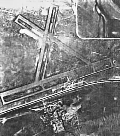
A 1947 aerial view of McDougall Field, courtesy of Robert Pearson.
At its height, the airport consisted of 3 paved runways (each with parallel taxiways):
5,400' Runway 6/24, 4,200' Runway 11/29, and 3,960' Runway 18/36.
Robert Pearson recalled, "I became interested in old airports as a child growing up in Pocatello, ID.
I can remember the McDougall terminal building from that period.
It had a restaurant & small lobby on the first floor & a control tower was the second floor.
There were 3 hangars to the east of the terminal.
The restaurant was called The Pilot House;
they are still in business but not at the airport anymore.
There is a concrete pad behind the terminal where the airliners parked."
Robert Pearson found book which described McDougall Field,
"From Jennies to Jets: The History of Aviation in the Pocatello Area" by Kathy Albano.
"The book from the library refers to lengthening the main runway for the bigger planes, probably DC-3s."
The much larger Pocatello Army Airfield (to the west) was closed by the military & obtained by the City of Pocatello to be used as a commercial airport,
eventually replacing McDougall Field.
The last aeronautical chart depiction which has been located of Pocatello Municipal Airport was on the April 1949 Pocatello Sectional Chart.
It depicted Pocatello Municipal Airport as having a 5,600' paved runway.
McDougall Field was evidently closed in 1949, as it was no longer depicted on the September 1949 Pocatello Sectional Chart.
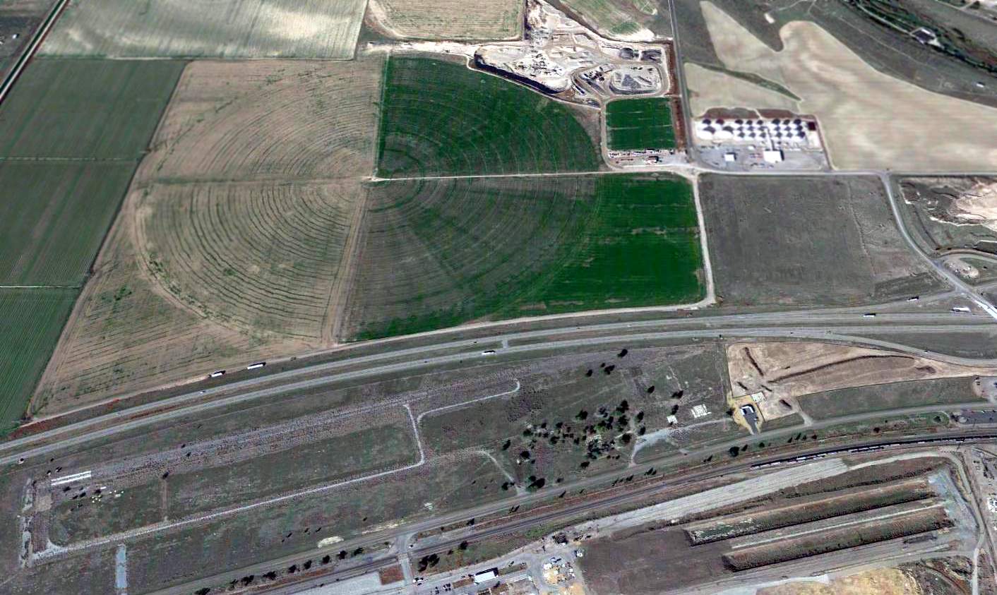
The 1969 USGS aerial photo shows that Interstate 86 had been built right through the center of the McDougall Field property.
The northern portion of the north/south & northwest/southeast runways were broken up & the land returned to farming.
The western half of the east/west runway was the only runway portion to remain.
The former McDougall Fieldeast/west runway was depicted as “Drag Strip” on the 1971 USGS topo map, but the other 2 runways were no longer depicted at all.
Drag racing historian Bret Kepner recalled of McDougall Field, "It was operated as Intermountain Dragway & hosted several large events in its life span.
At the time it was purchased, it was in such poor condition it wouldn't have been around much longer, anyway...
extremely rough deteriorating surface."
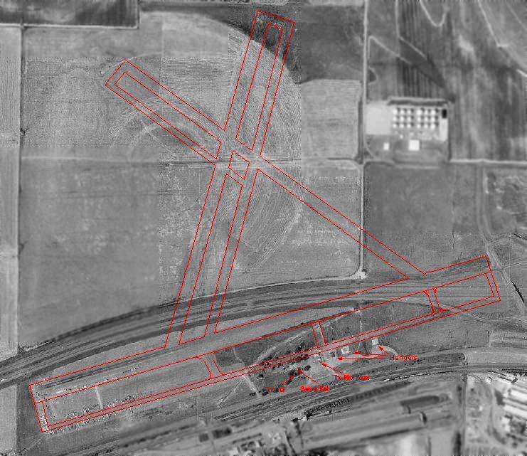
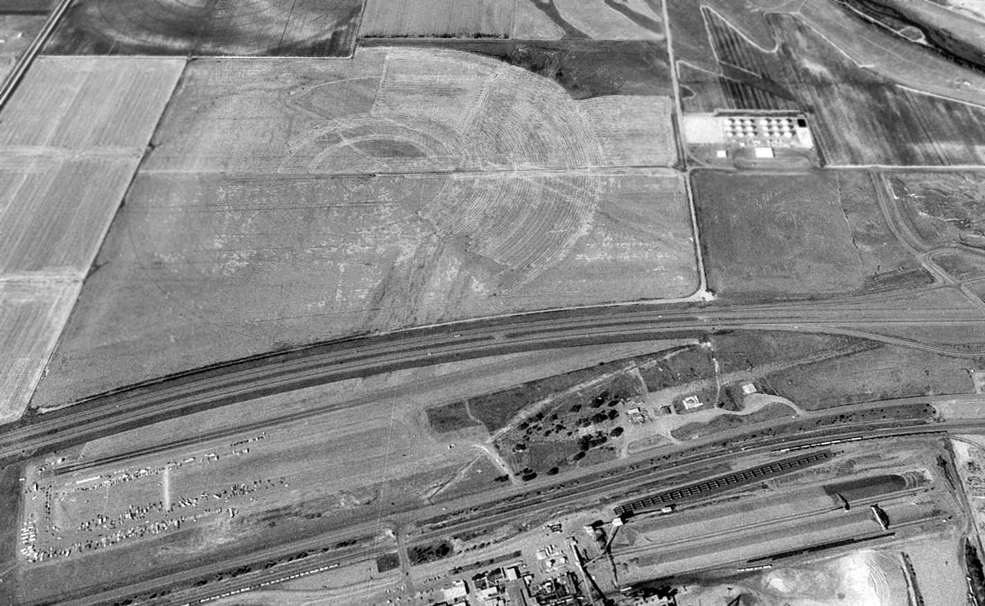
A 1992 USGS aerial photo overlaid by Robert Pearson with the outline of the former McDougall Airport.
In the photo, slightly more than half of the former east/west runway still existed,
whereas Interstate 86 covers the eastern portion of the runway.
The "ghosted" outline of the other two runways were still barely recognizable in the fields north of the Interstate.
The foundations of several hangars were still perceptible as well.
A 1993 USGS aerial view looking north at the site of McDougall Field, in which the outlines of the former runways were still barely apparent.
Robert Pearson recalled in 2003, "The airport was used as a drag strip for several years
but about 10 years ago [1993] that operation was shut down when FMC (the big factory just to the south) bought the property."
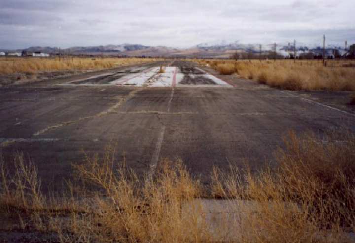
A 2002 photo by Robert Pearson of the remains of the east/west runway of McDougall Airport.
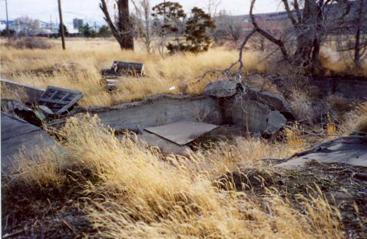
A 2002 photo by Robert Pearson of the remains of the terminal building at McDougall Airport.
Robert Pearson visited the site of the former McDougall Field in 2002.
"I walked the entire field up to the interstate highway & the far eastern end in the intersection of the highway.
I found the far edge so I'm sure that is the runway end."
Brandon Williams reported in 2006, “The field has changed somewhat, deteriorating over the last 4 years.
I walked almost the full length of the remaining portion of the runway.”
He noted the remains of “taxiways, the runway,
debris which might have once been part of the terminal (including some stall doors & a toilet)
and the overgrown pavement & remnants of the former drag strip as well.”
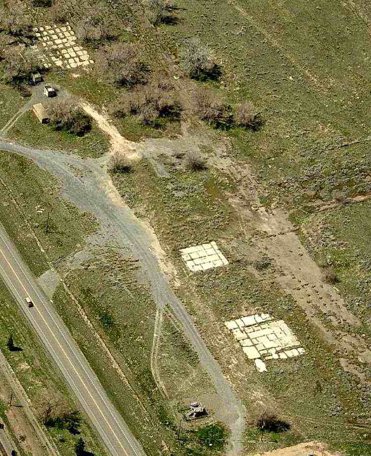
A circa 2010 aerial view looking west at foundations from former airport buildings or hangars at the site of McDougall Airport.
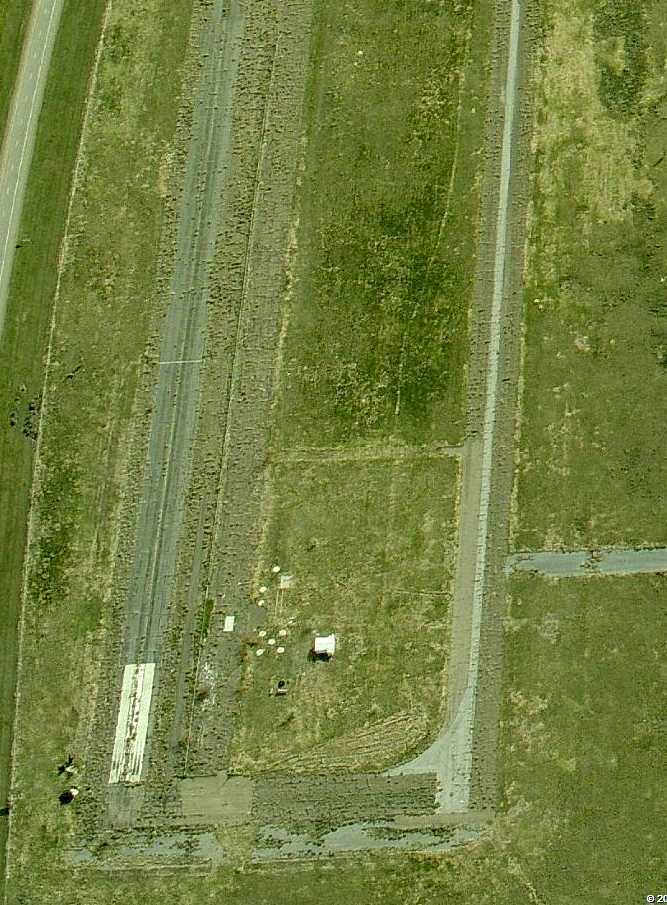
A circa 2010 aerial view looking east at the remains of McDougall's Runway 6 & its parallel taxiway.
A 2014 aerial view looking north at the site of McDougall Field, in which the remains of Runway 6/24 were still extant, outlines of the former runways were still barely apparent.
The site of McDougall Field is located south of Interstate 86, west of its intersection with Route 30.
____________________________________________________
Or if you prefer to contact me directly concerning a contribution (for a mailing address to send a check),
please contact me at: paulandterryfreeman@gmail.com
If you enjoy this web site, please support it with a financial contribution.
____________________________________________________
This site covers airfields in all 50 states.