Abandoned & Little-Known Airfields:
Northern Delaware
© 2003, © 2026 by Paul Freeman. Revised 7/5/26.
This site covers airfields in all 50 states: Click here for the site's main menu.
____________________________________________________
Please consider a financial contribution to support the continued growth & operation of this site.
Bellanca Field / Piasecki Field (revised 2/14/26) - Biggs Airport (revised 7/5/26) - Dover Airpark (revised 9/26/24)
DuPont Airport (revised 9/26/24) - Evergreen Acres Airport (revised 3/8/24) - Lovett Field / Weimer Field (revised 2/10/20) - Red Lion Airport (revised 1/8/18)
____________________________________________________
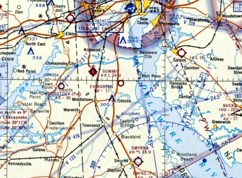
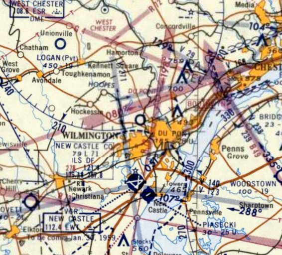
Evergreen Acres Airport (36N), Evergreen Acres, DE
39.497, -75.645 (Southwest of Wilmington, DE)
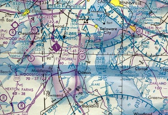
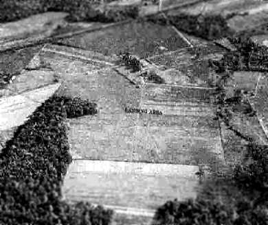
Evergreen Airport, as depicted on the March 1966 Washington Sectional Chart (courtesy of Jonathan Westerling).
Photo of the airport while in use is not available.
This little general aviation airport was evidently established at some point between 1965-61,
as it was not yet depicted on a 1954 aerial photo nor on the April 1965 Washington Sectional Chart.
The earliest photo which has been located of Evergreen Airport was a 1961 aerial view.
It depicted Evergreen Airport as having 2 unpaved runways, with a complex of small buildings on the west side.
The earliest aeronautical chart depiction which has been located of Evergreen Airport was on the March 1966 Washington Sectional Chart (courtesy of Jonathan Westerling).
It depicted Evergreen Airport as having a 1,700' unpaved runway.
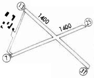
The 1969 Flight Guide (courtesy of Jonathan Westerling) depicted Evergreen Acres Airport as having 2 unpaved 1,400' runways,
with a complex of small buildings on the west side.
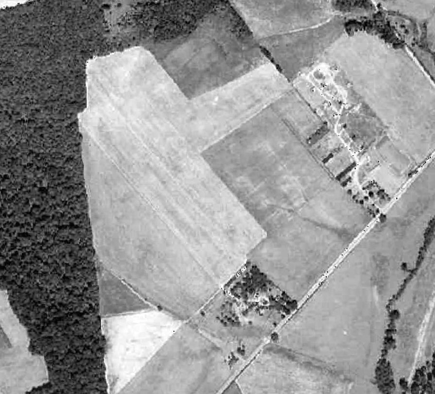
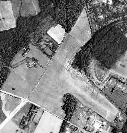
The only photo which is available of Evergreen Airport was a 9/14/69 NASA aerial view.
It depicted Evergreen Airport as having 2 unpaved runways, with a complex of small buildings on the west side.
The 1974 Flight Handbook (courtesy of Jonathan Westerling) depicted Evergreen Acres Airport as having 2 unpaved 1,400' runways.
The 1975 Flight Handbook (courtesy of Jonathan Westerling) described Evergreen Acres Airport as a private airfield.
A 1982 aerial photo showed Evergreen Acres Airport as remaining intact, but the runways were less distinct.
The last airport directory entry which has been located of Evergreen Acres Airport was in the 1983 AOPA Airport's USA directory (courtesy of Jonathan Westerling).
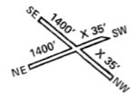
It described Evergreen Acres Airport as a private airfield having a single 1,400' turf Runway 13/31.
The last aeronautical chart depiction which has been located of Evergreen Airport was on the March 1987 Washington Sectional Chart.
It depicted Evergreen Airport as having a 1,400' unpaved runway.
Jonathan Westerling reported, “In the 1980s the state began planning a 'relief route' for Highway 13 which was immediately to the west of the airfield.
The result was that the new highway was aligned right through the airfield.
The fact that this little airport met its end due to the construction of an interstate highway isn't in any way unique,
but the fact that it happened in the late 1980s makes it one of the more recent airfields to suffer this fate.”
Evergreen Acres Airport was evidently closed at some point between 1983-89.
as it was no longer depicted on the 1989 Washington Sectional (according to Jonathan Westerling).
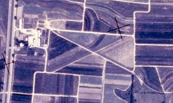
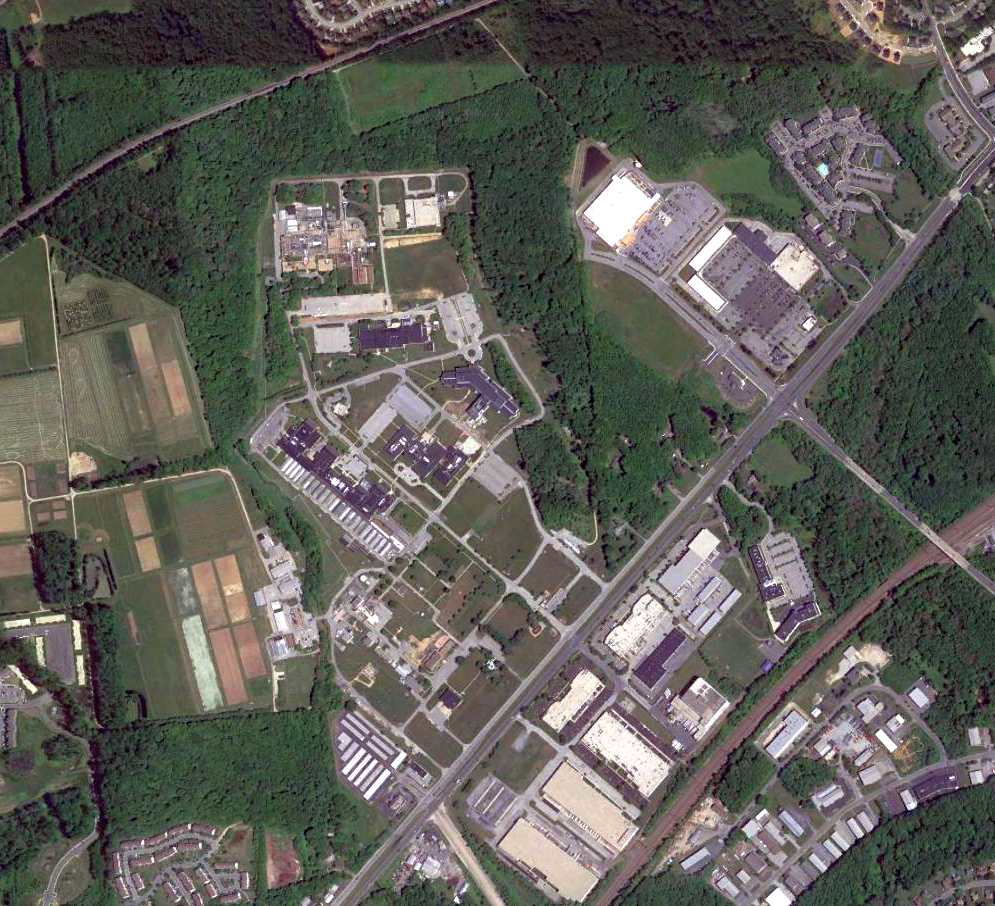
A 1992 aerial photo showed a road (Avian Way) & houses had been built over the eastern half of Evergreen Acres Airport.
A 2002 aerial photo showed a highway having covered the western half of the Evergreen Acres Airport site.
A 2006 aerial photo showed the buildings from the western portion of the Evergreen Acres Airport site had been removed.
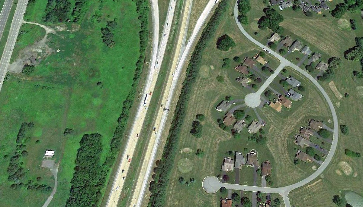
A 2018 aerial view looking north at the site of Evergreen Acres Airport, showed the only trace is the remains of pavement at the site of the former buildings from the west side of the airport, at top-left.
Thanks to Jonathan Westerling for pointing out this airfield.
____________________________________________________
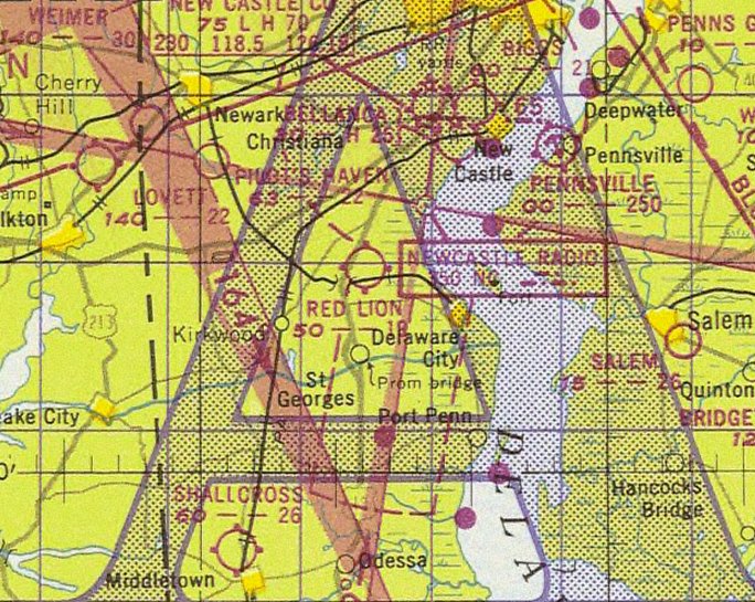
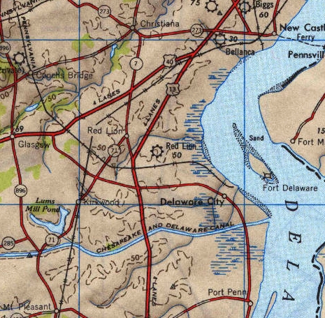
Red Lion Airport, Red Lion, DE
39.6, -75.644 (Southwest of Wilmington, DE)
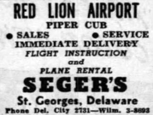
An advertisement for Seger's at Red Lion Airport from the 11/9/46 Wilmington Morning News (courtesy of Ken Finlayson).
This short-lived little general aviation airport may have been established at some point in 1946,
as it was not yet depicted on the 1946 Washington Sectional Chart.
The earliest reference to Red Lion Airport which has been located was an advertisement for Seger's from the 11/9/46 Wilmington Morning News (courtesy of Ken Finlayson).
It described Seger's as a Piper Cub dealer offering sales, service, flight instruction, and plane rental.
The earliest depiction which has been located of Red Lion Airport was on the 1947 Washington Sectional Chart.
It depicted Red Lion Airport as having a 1,900' unpaved runway.
Ken Finlayson recalled, “My dad (Kenneth Finlayson) used to fly with my grandfather in a plane (N2712K) that he was fractional owner of out of the Red Lion Airport around 1947.
He was part of 'The Flying Ten' club.”
The only topo map depiction which has been located of Red Lion Airport was on the 1948 USGS topo map.
The last depiction which has been located of Red Lion Airport was on the 1949 Washington Sectional Chart.
It depicted Red Lion Airport as having a 1,900' unpaved runway.
Red Lion Airport was evidently closed (for reasons unknown) at some point between 1949-51,
as it was no longer depicted on the 1951 Washington Sectional Chart.
A 1951 aerial photo didn't show anything recognizable as a former airfield at the rough location of Red Lion Airport – just farm fields.
A 2016 aerial view showed that no recognizable trace at the rough location of Red Lion Airport.
Thanks to Ken Finlayson for pointing out this airfield.
____________________________________________________
39.19, -75.531 (South of Wilmington, DE)
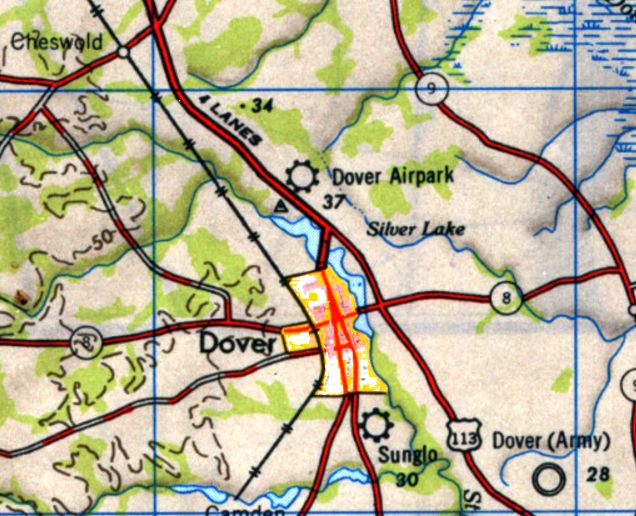
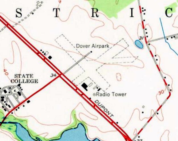
Dover Airpark, as depicted on the 1946 USGS topo map.
This small general aviation airport on the north side of Dover was evidently established at some point between 1945-46,
as it was not yet depicted on the December 1945 Washington Sectional Chart.
The earliest depiction which has been located of Dover Airpark was on the 1946 USGS topo map,
which depicted Dover Airpark as a municipal/commercial airport.
The earliest aeronautical chart depiction which has been located of Dover Airpark was on the April 1946 Washington Sectional Chart.
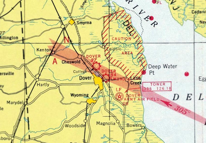
Note that it depicted 3 airfields in close proximity to the town of Dover: Dover Airpark to the north, the short-lived Dover Municipal Airport to the east,
and Dover Army Airfield to the southeast.
The 1947 Washington Sectional Chart depicted Dover Airpark as having a 2,500' unpaved runway.

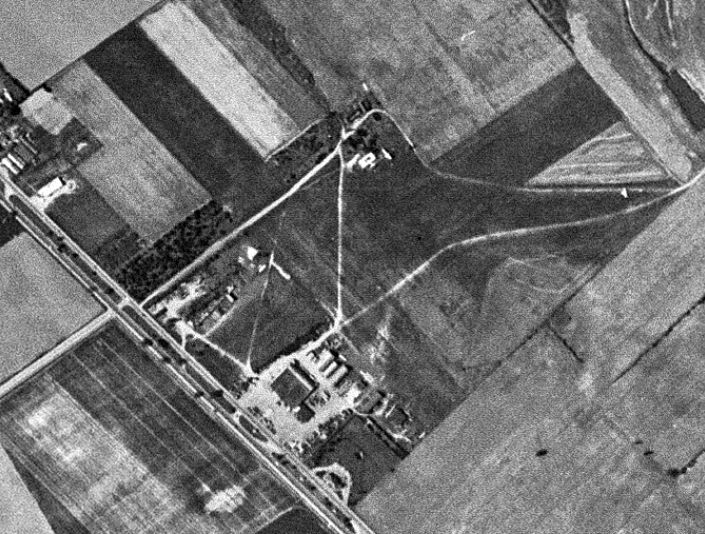
The earliest photo which has been located of Dover Airpark was a 4/23/51 USGS aerial view.
It depicted Dover Airpark as having 3 grass runways, with a row of T-hangars on the west side, but no aircraft were visible on the field.
The 1956 USGS topo map depicted Dover Airpark as having 3 unpaved runways, with 5 small buildings & a radio tower on the south side.
The last photo which has been located of Dover Airpark was a May 1957 USGS aerial view.
It depicted Dover Airpark as having 3 grass runways, with a row of T-hangars on the west side, but no aircraft were visible on the field.
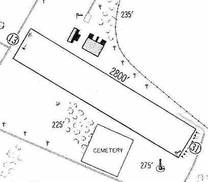
The last aeronautical chart depiction which has been located of Dover Airpark was on the March 1967 Washington Sectional Chart.
It depicted Dover Airpark as a private airfield having a 2,800' unpaved runway.
Dover Airpark was evidently closed at some point between 1967-70,
as it was no longer depicted on the 1970 Washington Sectional Chart.
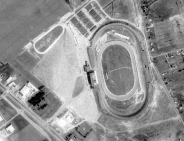
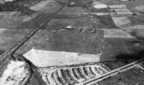
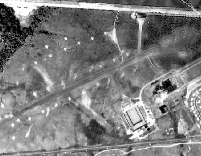
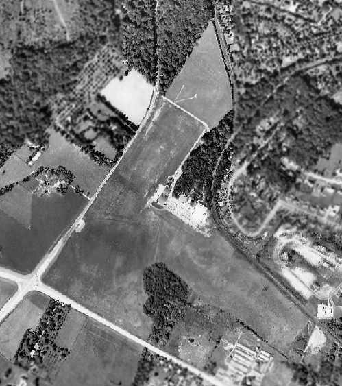
A May 1973 USGS aerial photo showed the site of Dover Airpark had been covered by the Dover Downs racetrack, still under construction.
No trace of the airport remained.
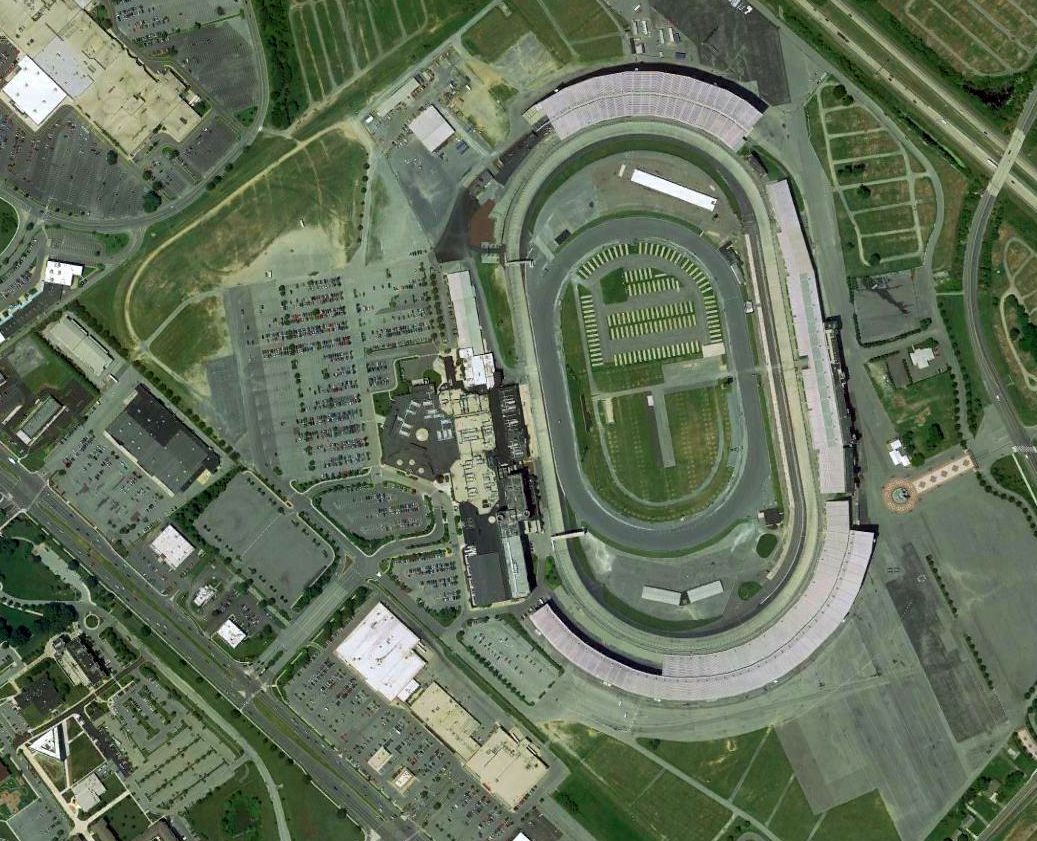
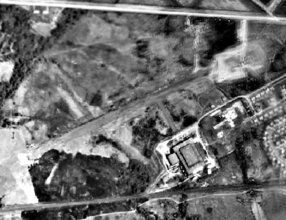
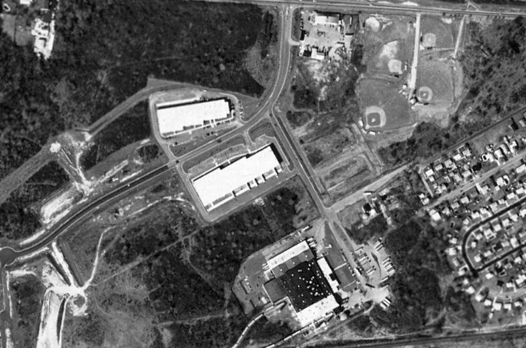
A 2015 aerial photo showed no trace remaining of Dover Airpark, with Dover International Speedway covering the site.
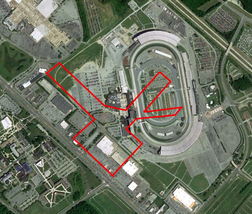
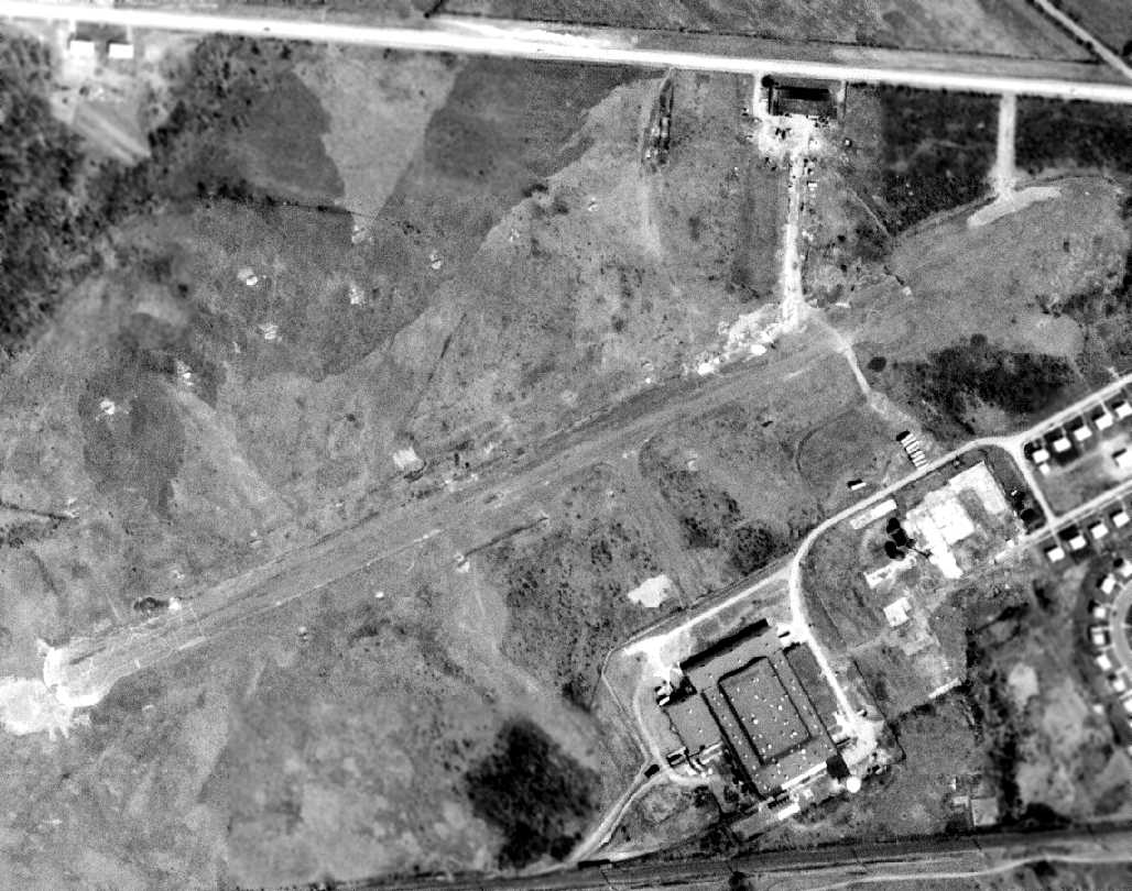
A 2018 aerial view of the site of Dover Airpark, annotated by Peter Vercruijsse to show the runway layout superimposed over the current Dover International Speedway covering the site.
The site of Dover Airpark is located north of the intersection of North Dupont Highway & College Road.
____________________________________________________
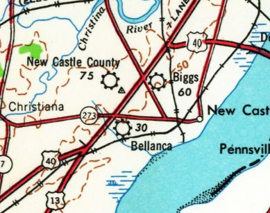
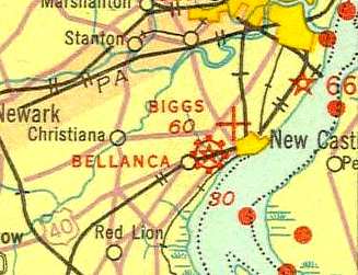
39.68, -75.58 (Southeast of Wilmington Airport, DE)
Biggs Airport was depicted as an auxiliary airfield on the October 1933 Washington Sectional Chart.
Biggs Airport was evidently established at some point between 1932-33,
as it was not yet depicted on the May 1932 Washington Sectional Chart.
The earliest depiction which has been located of Biggs Airport was on the October 1933 Washington Sectional Chart,
which depicted Biggs as an auxiliary airfield.
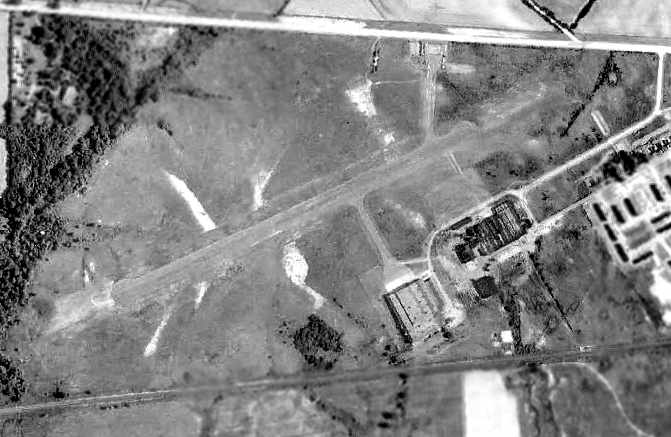
The earliest photo which has been located of Biggs Airport was a 1937 USDA aerial view,
which depicted an irregularly-shaped grass field with a few small buildings (hangars?) along the south side.
No aircraft were visible on the field.
A 1940 aerial photo depicted Biggs Field in the same manner.
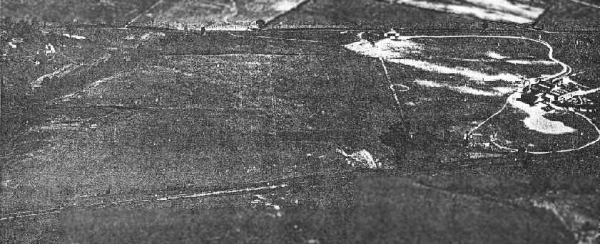
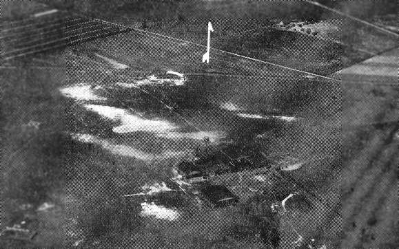
A 10/20/43 aerial view looking north at Biggs Field from the 1945 AAF Airfield Directory (courtesy of Scott Murdock).
It depicted Biggs as an open grass area.
The May 1944 Washington Sectional Chart (courtesy of Ron Plante) depicted Biggs as a commercial/municipal airport.
The 1945 AAF Airfield Directory (courtesy of Scott Murdock) described Biggs Field as a 60 acre property having a sod all-way airfield measuring 2,100' east/west.
It was said to have a total of 12 hangars, and to be owned & operated by private interests.
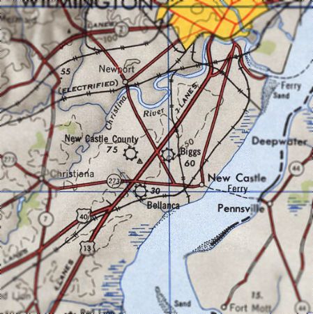
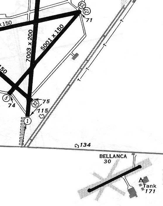
Biggs Airport was depicted on the 1946 USGS topo map in close proximity to 2 other Wilmington-area airports: New Castle County Airport & Bellanca Field.
What an air traffic nightmare that must have been.
Biggs Airport was listed as an Esso aviation products dealer in a 1946 advertisement.
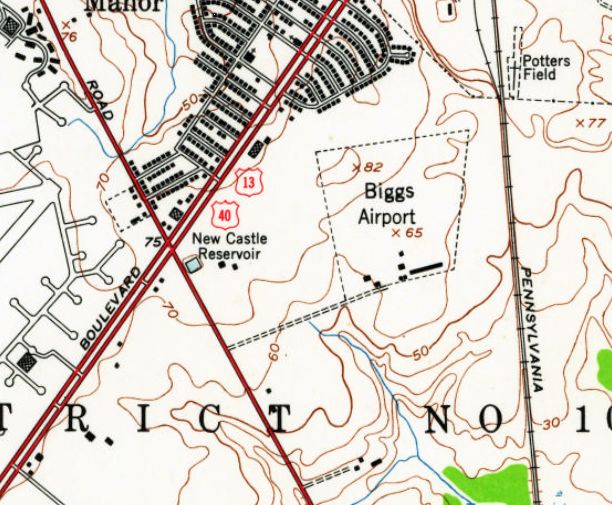
The most detailed depiction which has been located of Biggs Airport was on the 1948 USGS topo map.
It depicted Biggs Airport as an irregularly-shaped outline with 6 small buildings (hangars?) along the south side.
Note the runways of New Castle County Airport less than a half-mile to the west.
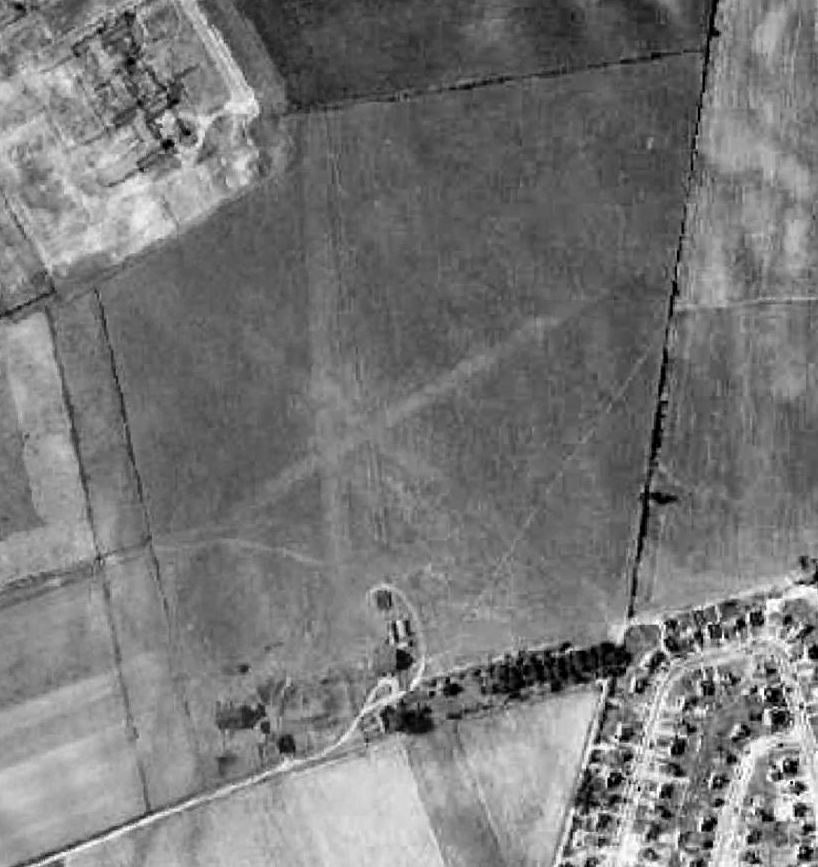
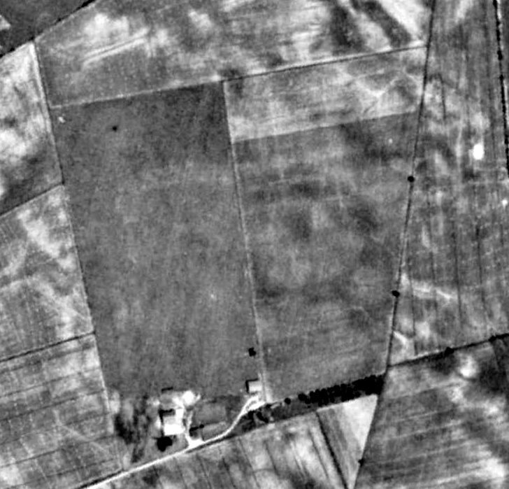
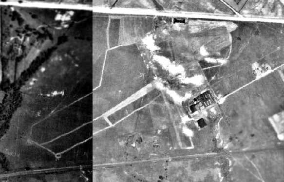
A 1954 USDA aerial photo still depicted Biggs Airport as an irregularly-shaped grass field with a few small buildings (hangars?) along the south side.
No aircraft were visible on the field.
The last aeronautical chart depiction which has been located of Biggs Airport
was on the 1955 Washington Sectional Chart (courtesy of Mike Keefe).
It depicted Biggs as having a 2,100' unpaved runway.
Biggs Airport evidently closed at some point between 1955-57,
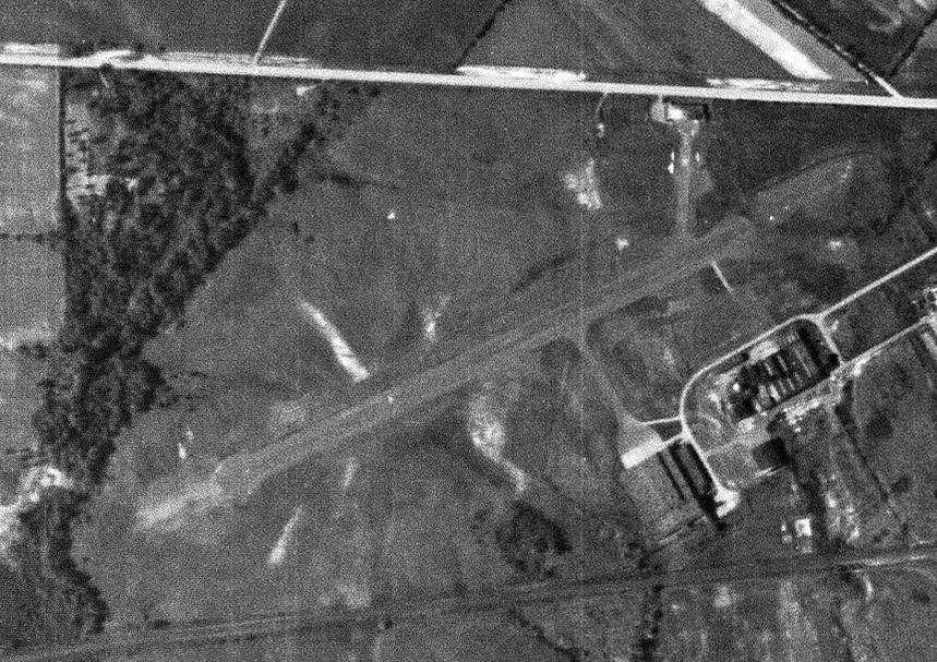
as a 5/2/57 USGS aerial photo depicted houses having been built along the northern half of the property.
A possible former hangar still remained along the south side of the Biggs Airport site.
Its business had been presumably been eclipsed by the much-larger New Castle County Airport, only a half-mile to the west.
The last depiction which has been located of Biggs Airport was on the 1959 USGS topo map.
Biggs Airport was no longer depicted on the 1960 Washington Sectional Chart (courtesy of Mike Keefe).
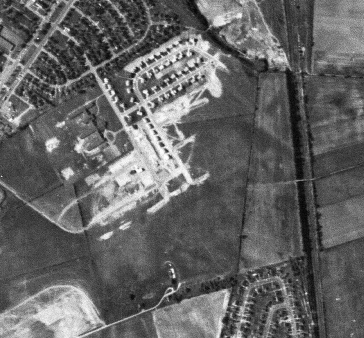
A 1970 aerial photo showed that houses had covered all of the Biggs Airport site.
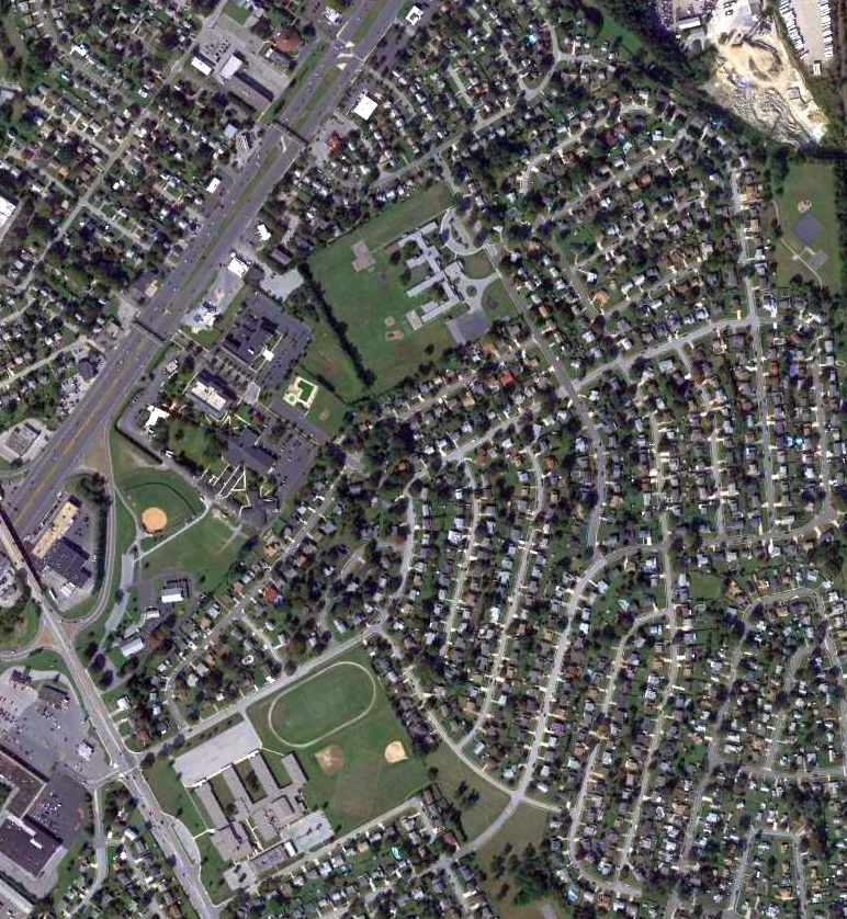
A 2011 aerial photo showed no trace remaining of Biggs Airport.
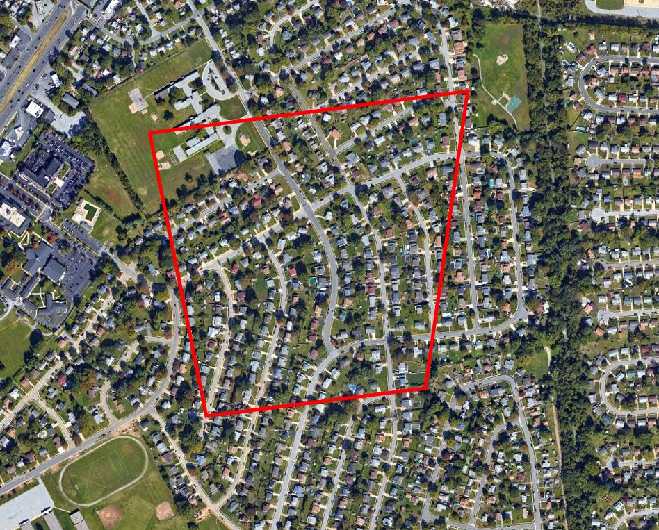
A 2016 aerial view of the site of Biggs Airport, annotated by Peter Vercruijsse to show the airfield perimeter superimposed over the neighborhood occupying the site.
The site of Biggs Airport is located at the intersection of Fithian Drive & Roosevelt Avenue.
____________________________________________________
Lovett Field (original location) / Weimer Field, Newark, DE
39.67, -75.78 (Southwest of Wilmington, DE)
Lovett Field, as depicted just east of the Delaware side of the state line on the November 1942 Washington Sectional Chart.
This small general aviation airport was named after its owner, Mr. Lovett.
Lovett Field was apparently built at some point in 1942,
as it was not yet depicted on the May 1942 Washington Sectional Chart.
The earliest depiction which has been located of Lovett Field
was on the November 1942 Washington Sectional Chart,
which depicted it just barely within the Delaware side of the state line.
The earliest photo which has been located of Lovett Field was a 10/20/43 aerial view
from the 1945 AAF Airfield Directory (courtesy of Scott Murdock).
It depicted the field as an open grass area.
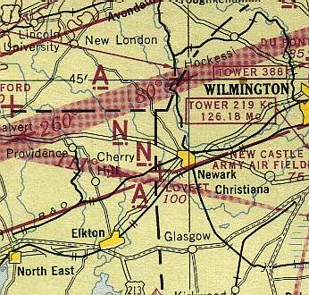
Lovett Field was still depicted on the Delaware side of the state line
on the 1944 Washington Sectional Chart (courtesy of Mike Keefe).
The 1944 US Army/Navy Directory of Airfields (courtesy of Ken Mercer) described Lovett as having a 2,000' runway.
The 1945 AAF Airfield Directory (courtesy of Scott Murdock) described Lovett Field
as an 40 acre irregularly-shaped property within which were 2 sod runways, measuring 2,000' NNW/SSE & 1,000' east./west.
The field was said to have three 40' x 26' metal hangars.
Lovett Field was said to be privately owned, but not currently in operation.
Lovett Field apparently was closed at its original Delaware location by 1945,
as it was not depicted at all on the 1945 Washington Sectional Chart (courtesy of John Voss)
nor on the 1946 Washington Sectional Chart (courtesy of Mike Keefe).
According to the book "Maryland Aloft" by Preston, Lanman, and Breilhan,
Lovett Field evidently was reopened at some point in 1946,
at a new location just to the west across the Maryland state line.
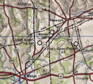
The 1946 USGS topo map showed that the former Lovett Field in Delaware had been reopened as Weimer Field by 1946.
The 1947 Washington Sectional Chart depicted Weimer Field as having a 3,000' unpaved runway.
Weimer Field evidently closed (for reasons unknown) at some point between 1947-49,
as it was no longer depicted at all on the 1949 Washington Sectional Chart or the 1953 USGS topo map.
A 1954 USDA aerial view showed that no recognizable trace appears to remain of the original location of Lovett Field.
A 2013 aerial view showed that no recognizable trace appears to remain of the original location of Lovett Field.
____________________________________________________
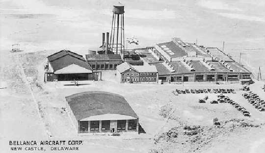
Bellanca Field / Piasecki Field, Wilmington, DE
39.66, -75.59 (Southeast of Wilmington Airport, DE)
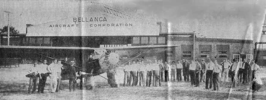
A 1928 photo of an unidentified monoplane in front of a “Bellanca Aircraft Corporation” hangar
at Bellanca Field (courtesy of Bill Long).
How many residents of the state of Delaware realize
that over 3,000 aircraft were built at a little airfield in their state?
That fact about the former Bellanca Field comes from the book "Delaware Aviation History" by George Frebert.
According to an article in the 10/10/03 issue of the Delaware NewsJournal,
Henry Francis du Pont brought in airplane designer Giuseppe Bellanca from New York
and bought the 360-acre Spring Garden Farm southeast of Wilmington in order to construct an aircraft factory & airport.”
An article entitled “Bellanca Field sold for industry, homes” in the 12/7/60 Wilmington News Journal said,
“The field was named after the Bellanca Aircraft Corporation which began operations there about 1926.”
According to an article in the 10/10/03 issue of the Delaware NewsJournal,
Bellanca Field was dedicated in 1928, at an event attended by 30,000 spectators,
who watched a performance by stunt fliers & parachute jumpers.
Joe Monigle recalled flying in a Bellanca Skyrocket in 1928 with his father, who was taking flying lessons.
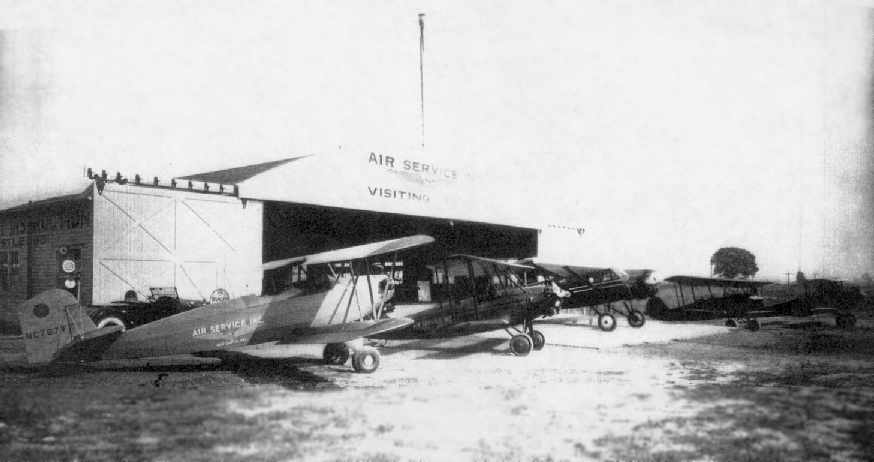
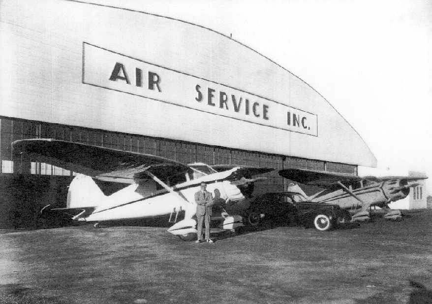
The original Air Service Inc. hangar was built in on the north side of Bellanca Field in 1928 by Henry Francis du Pont.
It was not part of the Bellanca factory, but was used for general aviation aircraft.
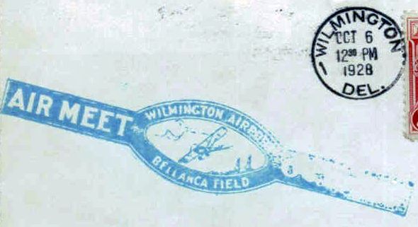
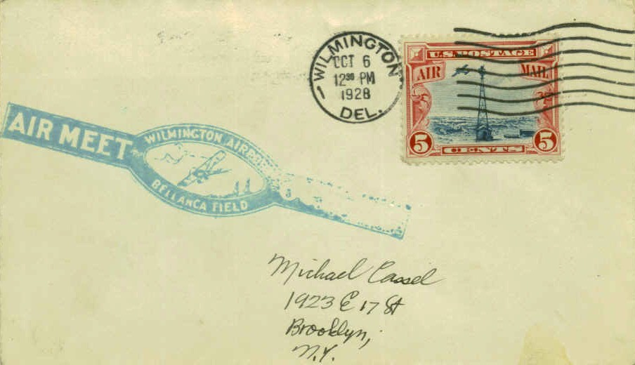
A postmark commemorated at 10/6/28 Air Meet at “Wilmington Airport Bellanca Field”.
In 1929, the Bellanca J Pathfinder (NC3789) was the 1st plane built in the new Bellanca Delaware plant.
It had been commissioned for a 7/9/29 transatlantic flight to Spain by Roger Williams & Lewis Yancey.
A total of 4 Bellanca Js were built, the others being NX4483, NX5315, and NX7085.
An undated photo of a Bellanca J (NX7086), the 4th plane built in the new Bellanca Delaware plant.
The 1929 "Rand McNally Standard Map of MD/DE With Air Trails" (courtesy of Chris Kennedy)
described Bellanca Field as consisting of a 3,500' x 3,000' field.
The 1930 "Rand McNally Standard Map of NJ With Air Trails" (courtesy of Chris Kennedy)
depicted Bellanca Field as being Airfield #65 along the Atlanta-NY Airway.
An aerial photo looking north at Bellanca Field from the 1930 book "Philadelphia Aeronautical Center of the East"
(courtesy of the George H. Stuebing Collection of the Delaware Valley Historical Aircraft Association).
The field was described as consisting of a 200 acre field, measuring 5,000' x 2,500'.
A single hangar was depicted on the north side of the field,
and the Bellanca factory buildings were depicted on the southeast side of the field.
An article entitled “Bellanca Field sold for industry, homes” in the 12/7/60 Wilmington News Journal said,
“Air Service Inc. was founded in 1930 by Richard Morgan, & A.R. Holdaday,
and for years provided flight instruction, student training, chartered flights, and aircraft maintenance.”
The first airplane to fly nonstop across the Pacific, the Bellanca "Miss Veedol", was built at Bellanca Field.
The plane, piloted by Clyde Panghorn & Hugh Herndon, flew in 1931 from Japan to Wenatchee, WA.
A 5/29/31 aerial view looking northeast at a regional air race held at Bellanca Field (from the Dallin Aerial Survey Collection, courtesy of the Hagley Museum & Library),
with numerous Army Air Corps planes in front of the original Air Service hangar.
A 6/28/31 photo by Harry Cassell (courtesy of Don Cassell) captioned “A Bellanca plane of the Fidelity Investment Association taken at the Bellanca Aircraft Company on a trip with the Baltimore Aero Club Inc.”
Bellanca Field, as depicted on the May 1932 J-18 Washington D. C. Airway Map (courtesy of Chris Kennedy).
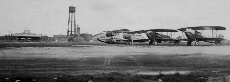
An undated photo (courtesy of Bill Long) of an amphibian plane, a Bellanca biplane,
and 2 Army fighters in front of the hangar marked "Bellanca Aircraft Corporation".
Bellanca Field, as depicted on the 1934 U.S. Navy Aviation Chart (courtesy of Chris Kennedy).
The 1934 Department of Commerce Airport Directory (according to Chris Kennedy)
described "Bellanca Field (Wilmington Airport)" as being a 3,800' x 2,000' sod field,
with a hangar with "Bellanca-Wilmington" painted on the roof.
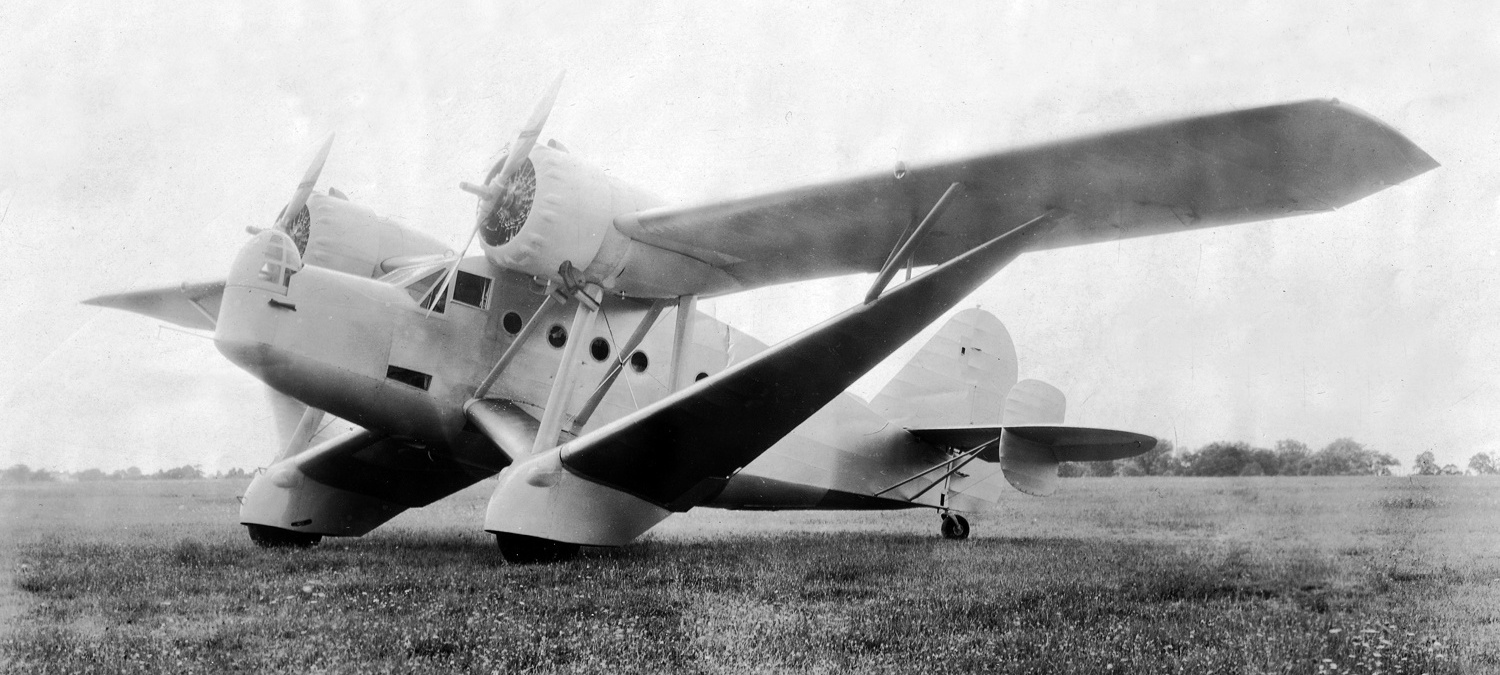
A 1934 photo of a rare Bellanca 77-140 at Bellanca Field. The 77-140 used features from the single-engine Bellanca Aircruiser. The USAAC was not interested, but 4 were sold to Columbia.
Bellanca Field's original Air Service hangar along the north side of the field burned down in 1934 but was rebuilt in 1935.
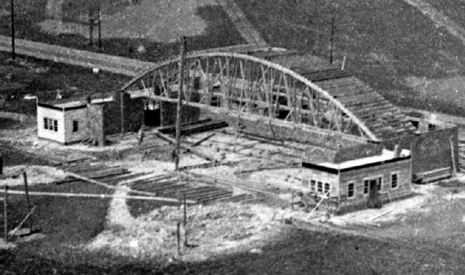
A 1935 photo of the new Air Service Hangar under construction at Bellanca Field.
Bellanca Field, as depicted on the 1935 Washington Sectional Chart.
Robert Stockman recalled, “Bellanca Field... my uncle took me to an air show there in the 1930s.”
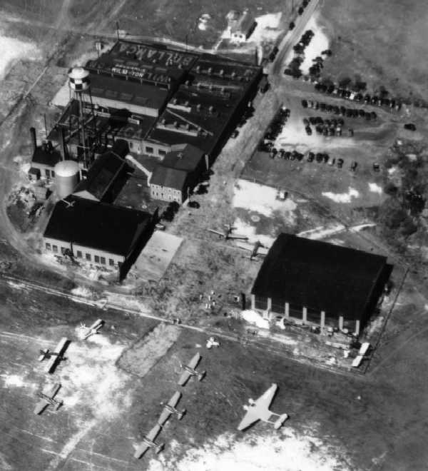
An undated aerial view looking north at Bellanca Field, showing the Air Services hangar along the north side,
as well as the Bellanca factory along the southeast side.
Aerial view looking north at Bellanca Field,
from the Airport Directory Company's 1937 Airports Directory (courtesy of Bob Rambo).
The directory described Bellanca Field as consisting of an irregular sod landing area.
The aerial photo in the directory depicted the factory buildings & hangars at the southern edge of the field.
A 1937 aerial view of Bellanca Field, showing the Air Service hangar on the north side of the field,
and the Bellanca factory & hangars on the southeast side of the field.
The airfield appeared to consist of a single unpaved southwest/northeast runway.
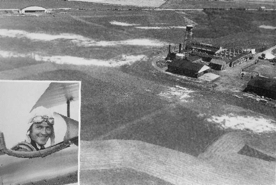
A 7/5/37 aerial view looking northeast at the Bellanca factory,
with 11 aircraft visible, including one of only 3 unusual Burnelli UB-14 “lifting fuselage” transports.
An undated aerial view of the Bellanca Factory at Bellanca Field .
An article entitled “Bellanca Field sold for industry, homes” in the 12/7/60 Wilmington News Journal said,
“Bellanca Field reached its peak just before WW2,
when a government-sponsored civilian pilot training program was operated there by Air Service.
Air Service Inc. closed down from 5/2/42 until April 1946 because most of the men associated with the firm were in the Air Force.”
Bellanca Field was still depicted on the 1942 Washington Sectional Chart (courtesy of Mike Keefe).
Ballanca Field was not depicted on the 1944 Washington Sectional Chart (courtesy of Mike Keefe).
It may have been temporarily closed due to wartime security restrictions,
as was the case at many other small civilian airfields during WW2.
Bellanca's New Castle plant reportedly produced 39 AT-21 trainers under license during WW2.
Their facility had the USAAF code of “BL”.
Bellanca Field still was not listed among active airfields in the 1945 AAF Airfield Directory (courtesy of Scott Murdock)
nor depicted on the 1945 AAF Aeronautical Approach Chart (courtesy of Mike Keefe).
Bellanca Field evidently reopened at some point between 1945-46,
as it was depicted once again as a commercial airport on the 1946 Washington Sectional Chart (courtesy of Mike Keefe).
An undated (circa 1940s?) photo of the Air Service hangar at Bellanca Field.
Bellanca Field, as depicted on the 1946 USGS topo map.
Bellanca Field evidently gained a paved runway at some point between 1937-48,
as the 1948 USGS topo map depicted it as having a single northeast/southwest paved runway,
with taxiways leading to the hangar on the northeast side & the factory on the southeast side.
The 1949 Washington Sectional Chart (courtesy of Mike Keefe)
described Bellanca Field as having a 2,500' hard-surface runway.
August Bellanca, the designer's son, worked at the Bellanca factory in the late 1940s & early 1950s.
Richard Sager recalled, “I worked at Bellanca in the machine shop starting in 1950 (might have been 1951).
When I started there the last Cruisair was being finished.
The factory then made sub-assemblies for other aircraft companies.
There was a section making fin & rudder assemblies for Martin & I also remember machining parts for Republic ejection seats.
There was also a section making radomes for I don't know who, but I remember machining some magnesium castings for them.”
The 1951 Washington Sectional Chart (courtesy of Mike Keefe)
described the field as having 3 runways, with the longest a 2,500' hard-surface runway.
A 1954 aerial view of Bellanca Field, showing the Air Service hangar on the north side of the field,
and the Bellanca factory & hangars on the southeast side of the field.
The largest hangar on the field, to the southwest of the factory, had been added at some point between 1937-54.
The airfield consisted of a single paved northeast/southwest runway, along with 2 unpaved runways on the west side.
Richard Sager recalled, “I believe the place was sold to Piasecki when I left in 1954.
I was probably laid off because of the sale.”
Bellanca ceased manufacturing aircraft at Bellanca Field in 1954,
their proud run having come to an end after 26 years.
The airfield continued in operation for a few more years, though.
Bellanca Field (bottom-right), as shown in relation to Wilmington Airport (top-left), as depicted on a 1956 Approach Plate (courtesy of Tom Beamer).
Bellanca Field was depicted as having a single 2,600' paved northeast/southwest runway, and 2 other shorter unpaved crosswind runways.
A taxiway led to the factory buildings on the south side of the airfield.
According to Bill Long, the 1956 Washington Sectional Chart described Bellanca Field as having 3 runways, with the longest being 2,500'.
An article entitled “Bellanca Field sold for industry, homes” in the 12/7/60 Wilmington News Journal said,
“Bellanca Aircraft was sold in the mid-1950s to Sydney Albert.
He retained the name until he sold to Piasecki Aircraft Company in 1956.”
A 5/2/57 USGS aerial view showed the majority of the Bellanca Field appeared unchanged from the 1954 aerial photo.
The 1957 Washington Sectional Chart (courtesy of Chris Kennedy) depicted Bellanca Field under a different name - "Piasecki".
The field was used by the Piasecki helicopter company,
whose primary facilities were located just up the river in suburban Philadelphia.
The field was still depicted as "Piasecki" on the 1960 Washington Sectional Chart (courtesy of Mike Keefe).
Bellanca Field's old Air Service hangar was still in use until 1960.
An article entitled “Bellanca Field sold for industry, homes” in the 12/7/60 Wilmington News Journal said,
“Bellanca Field, a landmark in the New Castle area for more than 30 years, had been sold to a developer.
The only operation at the airport, Air Service Inc, will close at the end of this month.
The 400 acres were purchased to use the land for housing & industrial development.”
Bellanca Field was no longer depicted on the July 1961 Philadelphia Local Chart.
A 1961 aerial view showed the majority of Bellanca Field appeared unchanged from the 1957 aerial photo,
although it appears as if some of the factory buildings on the southeast side of the field may have been removed.
There was also the appearance of multiple unidentified light-colored features along both sides of the runway.
William Mitchem recalled, "As a son of a former pilot, my father took me to the Bellanca airfield a lot.
In the 1960s after it closed we would go there - my father taught my mother to drive on the runways, he taught me to drive on the runway."
Robert Stockman recalled, “Bellanca Field... In the 1960s it was a ruin.”
An 4/16/65 aerial view showed Bellanca Field to remain largely unchanged.
Strangely, the 1967 USGS topo map depicted a blank area at the location of Bellanca Field, with the runway & northern hangar not depicted at all.
Only the former factory on the southeast side was still depicted.
In the 1968 aerial view of Bellanca Field, the airfield was further deteriorated, but the majority of the length of the paved runway still remained intact,
as well as the hangar on the north side & the former Bellanca factory on the south side.
A 1970 aerial view still depicted the runway was intact.
Tom Beamer recalled, "I haven't flown into ILG [Wilmington] in some time,
but in the 1970s, possibly the 1980s, the Bellanca factory was still intact on short final from an ILS to [Runway] 1."
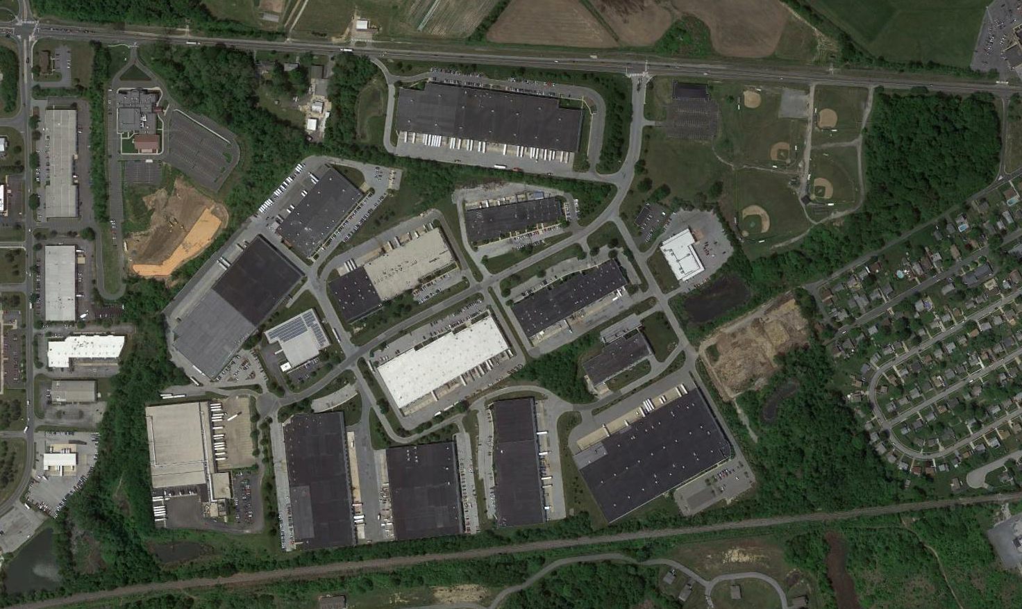
A 1992 aerial view of the site of Bellanca Field showed that the runway pavement had been removed at some point between 1970-92, with a street (Centerpoint Boulevard) & several industrial buildings in its place.
However the hangar on the north side & the former Bellanca factory on the south side remained standing.
A 1997 aerial view of the site of Bellanca Field showed the site essentially unchanged from that depicted in 1992, with the hangar & factory still intact.
Robert Stockman recalled, “Bellanca Field... may have become the site of an Amazon.com distribution center in the 1998-2000 era.”
Indeed, a 2002 aerial view of the site of Bellanca Field showed that the former Bellanca factory on the south side of the field had been replaced with a much larger building,
but the former Air Service hangar on the north side of the field remained intact.
In 2003, a grass-roots group named The Friends of Bellanca Airfield was formed.
It was seeking to preserve the old Air Service hangar - the sole remaining building at the former airfield -
and have it placed on the National Register of Historic Places.
The Trustees of New Castle Common, a group that oversees property for the common good of city residents,
owned the property where the former airplane hangar sat.
The trustees planned to raze the building unless someone stepped forward with the financial backing to restore it.
In 2003, about 100 people gathered at a ceremony to recognize Bellanca Field's contributions to aviation history.
Highlighting the event, which included flyovers by vintage airplanes,
was the unveiling of a historical marker near the old site at Route 273 & Centerpoint Boulevard.
It noted that approximately 3,000 aircraft were built at Bellanca Field between 1928-54.
"If you let history go by, you can only regret it," retired Delaware National Guard adjutant general Frank Ianni told the crowd.
He spearheaded the effort to have a plaque placed there.
Among the dignitaries who attended the ceremony was August Bellanca, of Annapolis, MD, the designer's son.
State Department of Transportation Secretary Nathan Hayward gave Friends of Bellanca hope
when he announced at the ceremony that the department would match up to $300,000
from its Transportation Enhancement Grant for contributions collected for the building's restoration.
"This is a wonderful piece of Delaware's transportation history, which is why we think it's important," he said.
Friends of Bellanca has suggested that the building could be converted into an aviation or even transportation museum,
given the history of the old airfield & other early New Castle operations.
"It would be a pity if it didn't survive," Friends member Joe Monigle said of the building.
Glenn Petrucci visited the site of Bellanca Field in 2006, and reported, “While I was there looking around,
a guy from Amazon stopped by thinking I was with the property developers.
Apparently, Amazon is considering expanding to the area where the old hangar now is, so the site may be completely gone sometime soon.”
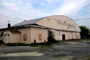
A circa 2006 aerial view looking north at the former Air Service hangar which remains on the north side of the former Bellanca Field.
A circa 2006 photo looking south at the former Air Service hangar which remains on the north side of the former Bellanca Field,
with 2 signs commemorating its historical significance.
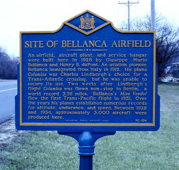
A pre-2010 photo of a historical plaque commemorating the site of Bellanca Airfield.
Elliott Smith, President of the Friends of Bellanca Airfield, reported in 2010,
“We are in the process of restoring & preserving the Air Services Hangar at Bellanca Airfield
and establishing a museum recognizing the contributions to Delaware's aviation history by the Bellanca Aircraft Corp.”
Robert Seastrom reported in 2011, “The restoration of the hangar at Bellanca continues apace.”
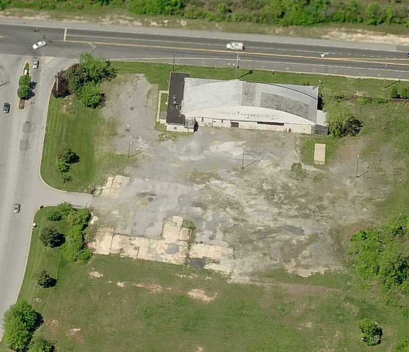
A 2016 aerial view of the site of Bellanca Field shows the Air Service hangar at top-right.
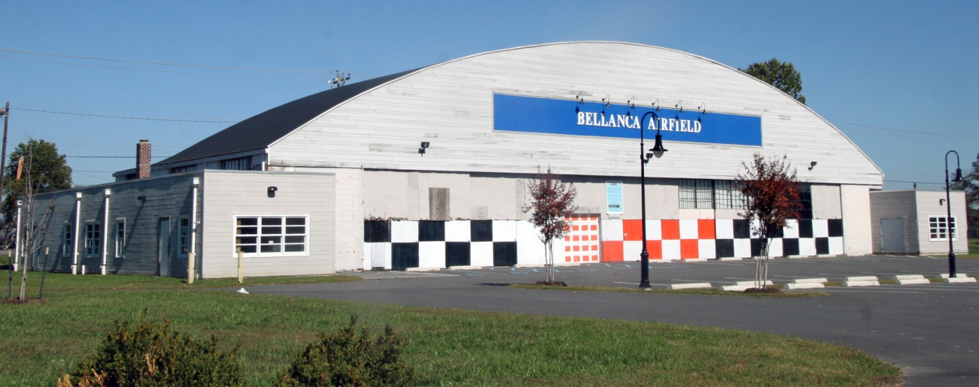
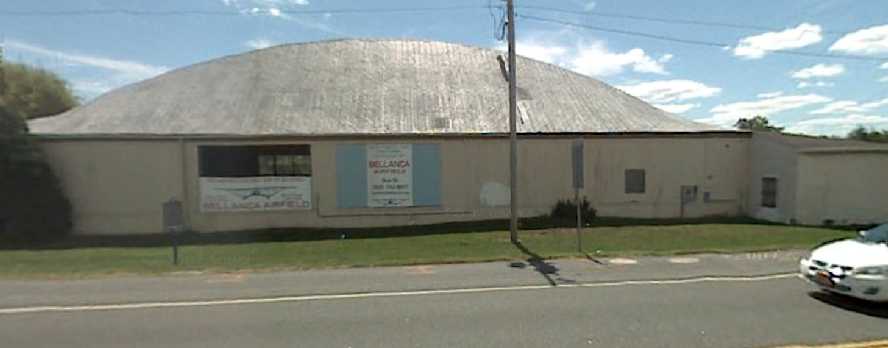
A 10/15/16 photo by Daniel Berek of the restored Bellanca Field Air Service hangar.
Daniel reported, “The airport no longer exists, but the hangar has been lovingly restored & is an aviation history museum.”

A 2023 photo looking northeast at the former Bellanca Field Air Service hangar.
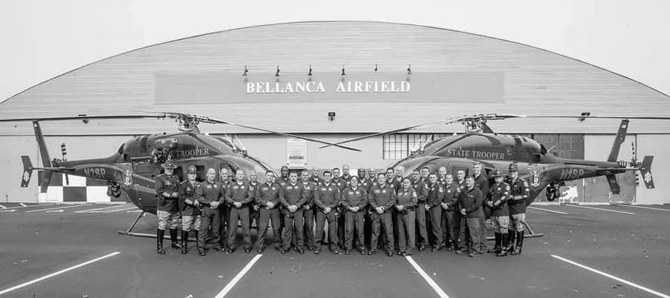
A 2023 photo of 2 Delaware State Police Bell 429s in front of the Bellanca Airfield hangar.
The site of Bellanca Field is located at the intersection of Johnson Way & Centerpoint Boulevard, only 1 mile southeast of Wilmington Airport.
Thanks to Bill Long for pointing out Bellanca Field.
____________________________________________________
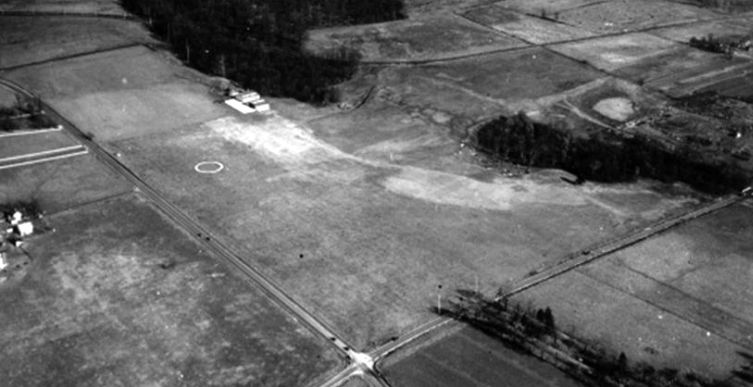
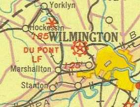
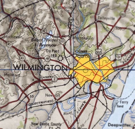
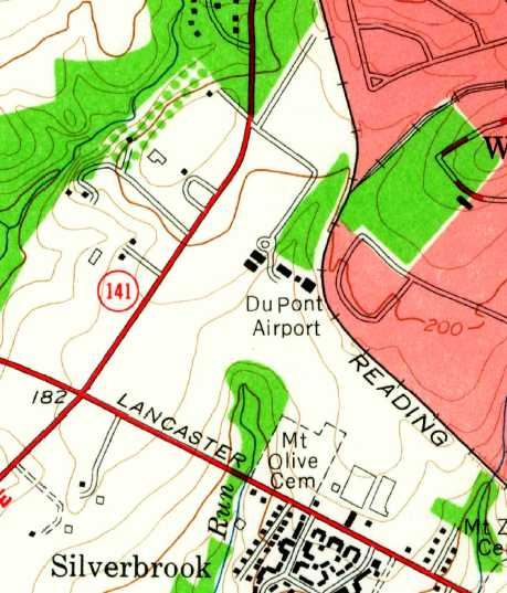
DuPont Airport, Wilmington, DE
39.76, -75.6 (Southwest of Philadelphia, PA)
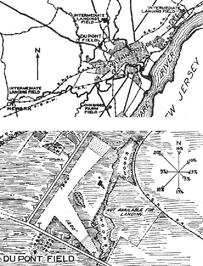
The location & layout of Du Pont Field, as depicted on a 1927 Commerce Department Airway Bulletin (courtesy of David Brooks).
According to the DuPont Daily News, the DuPont Airport was established in 1924 by Henry du Pont.
The earliest depiction which has been located of Du Pont Field was on a 1927 Commerce Department Airway Bulletin (courtesy of David Brooks).
It described Du Pont Field as a 45 acre irregularly-shaped property having 2 sod runways, measuring 1,900' northeast/southwest & 1,200 east/west,
with one 50' x 45' hangar.
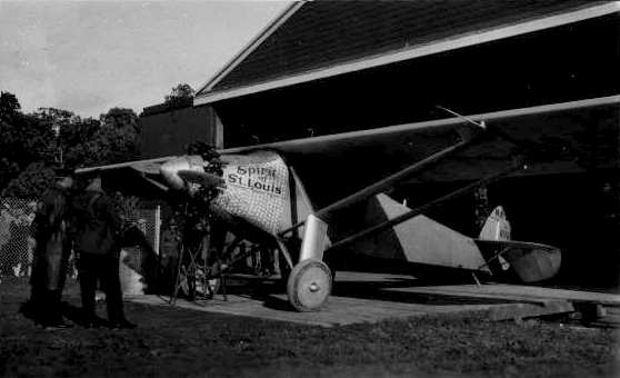
Lindbergh's "Spirit of St. Louis", pictured at DuPont Airport in 1927 (courtesy of Bill Long).
The 1929 "Rand McNally Standard Map of MD/DE With Air Trails" (courtesy of Chris Kennedy)
described Du Pont Field as being 1,900' x 1,200' in size.

Du Pont Airport, as depicted on the 1930 "Rand McNally Standard Map of New Jersey With Air Trails" (courtesy of Chris Kennedy).
The earliest aerial photo to be located of DuPont Airport was a 1931 aerial view looking northeast.
It depicted DuPont Airport as having a grass runway marked with an airport circle, and a ramp & 2 hangars on the east side.
Du Pont Airport, as depicted on the May 1932 J-18 Washington D. C. Airway Map (courtesy of Chris Kennedy).
A 6/29/32 aerial view looking northwest at DuPont Airport (from the Dallin Aerial Survey Collection, courtesy of the Hagley Museum & Library)
depicted the field as having a grass runway marked with an airport circle, and a hangar on the north side painted with “DUPONT” on the roof.
According to Clare Downes, “I believe in the early 1930s my Grandparents family [the Cannon family]
sold property & a farm house to one of the DuPont's to upgrade the facility.”
Du Pont Airport, as depicted on the 1934 U.S. Navy Aviation Chart (courtesy of Chris Kennedy).
The 1934 Department of Commerce Airport Directory (according to Chris Kennedy)
described Du Pont as a private field, with 2 sod runways forming a "T", with the longest being a 2,600' northeast/southwest strip.
The 1935 Washington Sectional Chart depicted DuPont as a commercial airport.
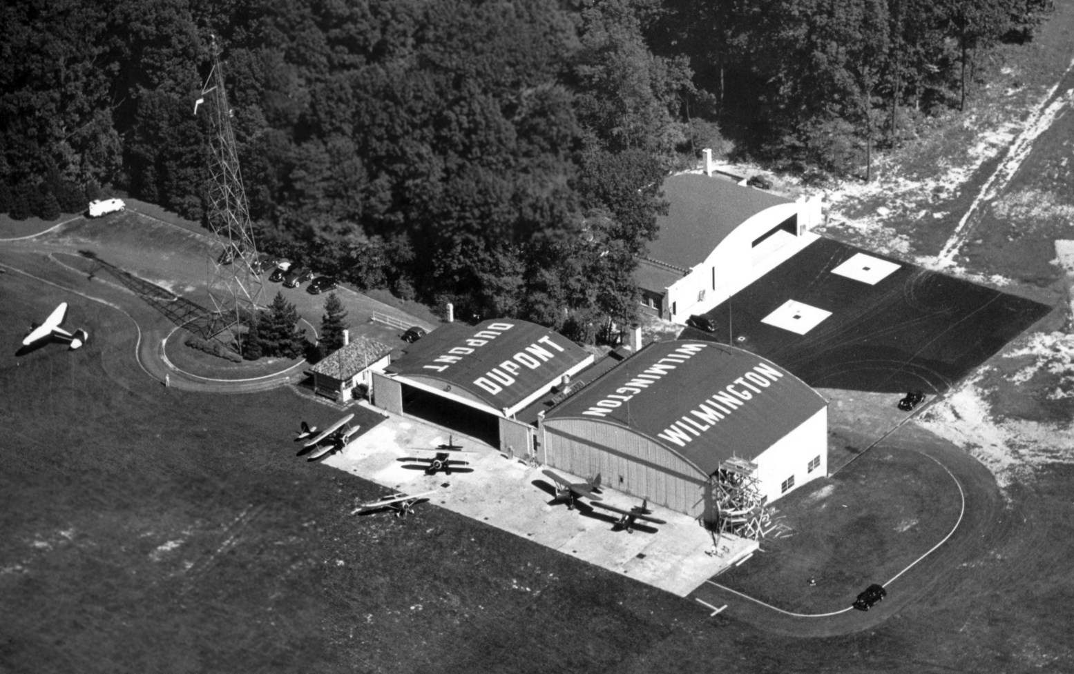
An undated aerial view looking east at DuPont Airport, from the Airport Directory Company's 1937 Airports Directory (courtesy of Bob Rambo).
The directory described DuPont Airport as having a T-shaped grass landing area, measuring 3,300' x 1,900'.
A hangar (with "DuPont, Wilmington" painted on the roof) was on the eastern side of the field.
A 1937 aerial view of DuPont Airport.
A 1937 view looking at 3 planes parked in front of the Atlantic Aviation hangars at DuPont Airport (from the Dallin Aerial Survey Collection, courtesy of the Hagley Museum & Library).
A 7/10/39 aerial view looking north at DuPont Airport (from the Dallin Aerial Survey Collection, courtesy of the Hagley Museum & Library)
showed 6 planes, a tall beacon tower, 3 hangars, and a control tower on the corner of a hangar.
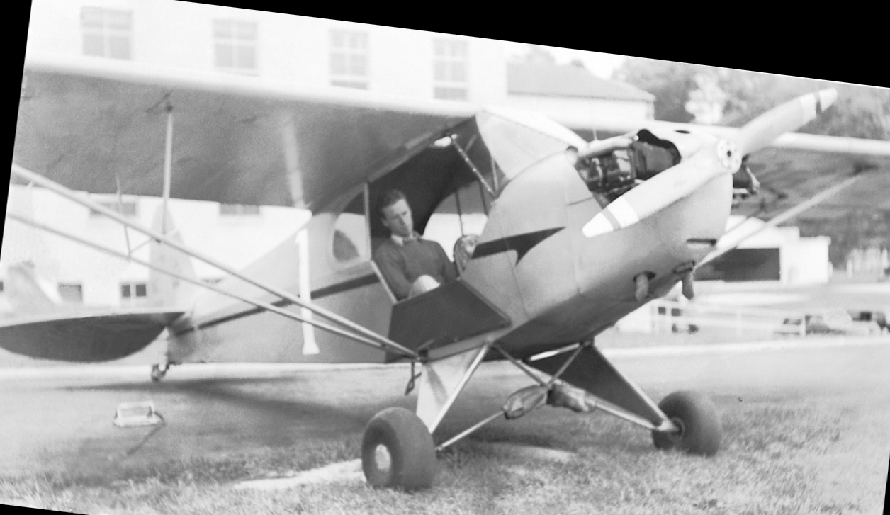
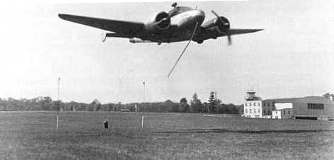
A circa 1941 photo of William Miller Jr. in a Piper J-3 Cub at Du Point Field (courtesy of his son, William Miller III).
William Miller III recalled, “My father attended the University of Delaware in the early 1940s, where he participated in Junior ROTC.
That included optional flight lessons at Dupont Field, through which he obtained his private pilot rating.”

A circa 1941 photo of a Fairchild in front of the Du Point Field hangar & control tower (courtesy of his son, William Miller III).
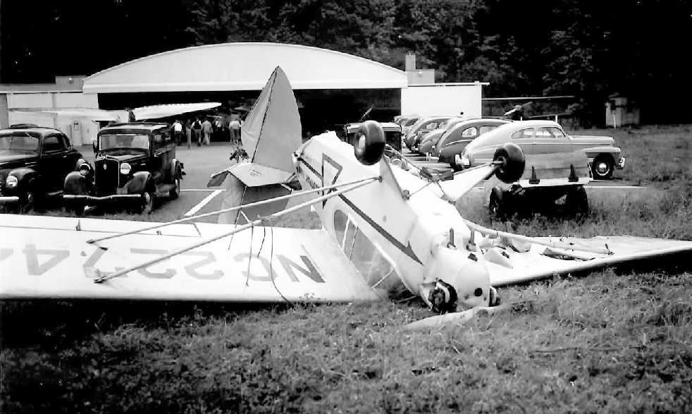
A 1941 photo (courtesy of Michael Hrischuk) of a Piper Cub flipped over at Du Pont Airport.
According to Michael Hrischuk, “Dupont Airfield... got hit by 90 mph winds in 1941, damaging many aircraft.”
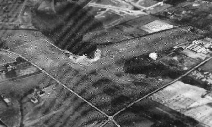
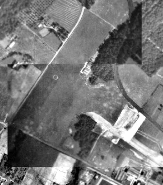
A 10/20/43 aerial view looking north at Du Pont Airport from the 1945 AAF Airfield Directory (courtesy of Scott Murdock)
depicted the field as having 2 grass runways.
In a 1941 aerial view of Du Pont Airport, the predominant characteristic of the field was its northeast/southwest grass runway, in the center of which was visible a circular airport marker.
Several hangars were visible along the east side of the runway.
Robert Stockman recalled, “In 1940 my family relocated to an apartment complex about a mile from duPont Field.
It became a hang-out for me as soon as I got my first bike in 1941.”
According to the book "Delaware Aviation History" by George Frebert,
DuPont Airfield had the honor at one time of hosting one of aviation's biggest heros, Charles Lindbergh.
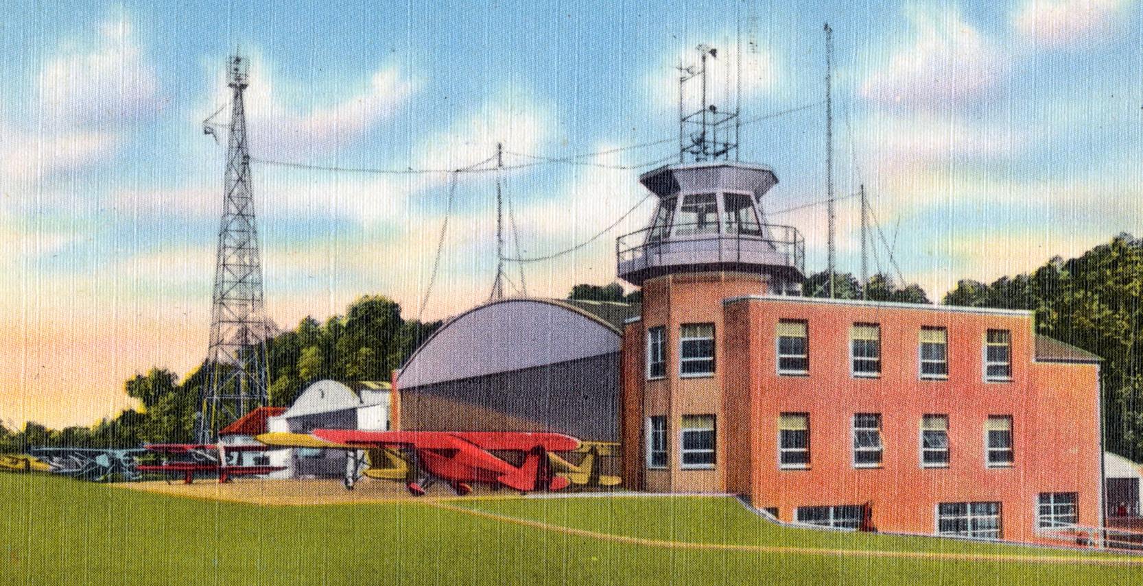
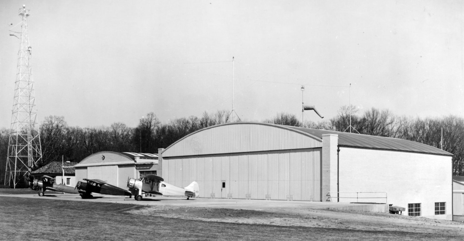
A pre-1942 postcard of Atlantic Aviation Service, DuPont Airport.
It depicted 2 fairly substantial hangars, along with a brick office building with a control tower on top (which had evidently been added at some point after 1939).
DuPont was depicted as a commercial airport on the 1942 Washington Sectional Chart.
The airfield became the home of All-American Aviation (a predecessor of USAirways),
which provided airmail service to communities in Pennsylvania, West Virginia, Ohio and Delaware.
All-American Aviation also was known for its development of arresting gear,
retrieval systems & launch systems, later used by the armed forces.
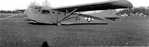
A circa 1943 photo of an unidentified Army glider waiting for a tow pick-up from a C-47 at Du Pont Airport (courtesy of Robert Veazey).
The May 1944 Washington Sectional Chart (courtesy of Ron Plante) depicted Du Pont as a commercial/municipal airport.
The 1945 AAF Airfield Directory (courtesy of Scott Murdock) described Du Pont Airport
as an 96 acre T-shaped property within which were 2 sod runways, measuring 2,900' northeast/southwest & 2,700' northwest/southeast.
The field was said to have 5 brick & steel hangars, the largest measuring 230' x 85'.
Du Point Airport was said to be privately owned & operated.
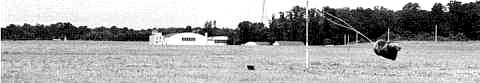
An undated photo of an airmail pickup at Du Pont Airport (courtesy of Robert Veazey).
Robert Veazey (who went on to become Manager of Aerial Recovery Programs at All American Engineering Company) recalled,
“I grew up in Wilmington, Delaware, and as a young boy I saw Stinson SR10C Reliants picking up mail pouches
at the DuPont Airport on the outskirts of town using that system.
I also remembered seeing CG-4 gliders being snatched into the air by C-47s.
Along with friends, I would sneak onto the field to see the goings-on
and drool over the wide variety of aircraft, both on the ground & in the air,
but we were frequently chased off by security guards.
It was there that I saw fairly close up my first B-17 & P-38, as well as several lesser-known planes.
The sign on the hangars identified the company working with all those beautiful airplanes as 'AlI American Aviation'.
An undated photo of a Beech D-18 performing an airmail pickup at Du Pont Airport (courtesy of Robert Veazey).
Du Pont Airport, as depicted on the 1946 USGS topo map.
Robert Stockman recalled, “We moved to a house about a mile away in 1946 or 1947.
Then I really spent time there helping wash & wax Cubs & Wacos & being rewarded with the occasional ride.
In 1949 I was driving down Lancaster Pike parallel to the runway
when a surplus P-38 landed long & plowed through the chainlink fence & flipped into a landfill behind a nursery.
My car became stuck in the nursery field, a lot of recent rain, but I was still among the first to reach the pilot.
He was OK but stunned. When the nursery owner saw what I did to his plants, he was stunned too.
When I called my father to help pull the car out his reaction left me stunned & grounded for a week.”
The 1949 Washington Sectional Chart (courtesy of Mike Keefe) described DuPont as having a 2,900' unpaved runway.
In a 4/7/50 USGS aerial view of Du Pont Airport, the southeast/northwest grass runway was much more evident than as was depicted in the 1941 photo.
At least 7 light aircraft were parked near the hangars.
Robert Stockman recalled, “I took flying lessons there in 1950-51.”
The 1951 Washington Sectional Chart (courtesy of Mike Keefe)
described DuPont as having 2 runways, with the longest a 2,900' unpaved strip.
According to Lorraine Smith, DuPont Airport "had a flight school run by Atlantic Aviation Service.
It was located one mile northwest of Wilmington.
The field had complete night lighting equipment & radio facilities.
Overhaul & repair service for aircraft were maintained day & night.
At one time I believe Allegheny Airlines operated out of there.
It was right next to a community called Westover Hills which was located right at the end of the runway.
I have some pictures that I took when I flew out of there in the early 1950s.
It was a beautiful grass "L" shaped field surrounded by a high chain link fence."
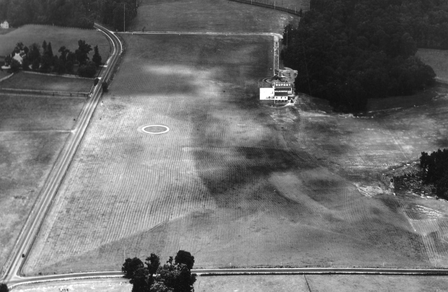
The 1954 USGS topo map depicted DuPont Airport as having a cluster of 5 buildings on the northeast side of the field.
A 1954 aerial view of Du Pont Airport showed least 7 light aircraft was parked along the east side of the northeast/southwest runway.
This is the last photo which has been located showing aircraft at DuPont Airport.
Robert Veazey recalled, “In 1954, I visited a friend working as an engineer for the All American Engineering Company at DuPont Airport.
During my visit I met the Chief Engineer, who, by coincidence, was an ex-fighter pilot,
and he offered me a job when my active duty was completed.
He said that the company was working on all sorts of things that a pilot I would find interesting.
So when my active duty service ended in March of 1955, I returned home & went to work at All American, or AAE as we called it.”
Robert continued, “AAE was a beehive of activity.
There were, I found out, all kinds of projects involving airborne winches & aircraft arresting gear.
There was also a T-6G equipped with ski-like devices on the landing gear to allow it to operate off water.
Behind locked doors was another project that no one would really talk about.
I found out later that it involved a system to enable an aircraft to engage & recover objects descending on a parachute,
using a technique (and equipment) closely resembling that used for the demonstration I saw at K-13.
The major activities were projects to develop ground-based catapults & arresting gear for both the USAF & the Navy/Marines.”
The 1957 Washington Sectional Chart (courtesy of Mike Keefe) described DuPont as having 2 runways, with the longest a 2,900' unpaved strip.
According to Bob Veazey, “Atlantic Aviation left Dupont Airport in 1958.”
Although the DuPont Daily News reported that the last flight from the DuPont Airport took place in 1958,
this was probably more accurately the date at which Atlantic Aviation left the airport, not when the airport truly had its last flight.
The last aeronautical chart depiction which has been located of DuPont Airport was on the January 1959 Washington Sectional Chart.
It depicted DuPont Airport as having a 2,800' unpaved runway.
The Du Pont Airport was evidently closed as an airport at some point in 1959,
as it was no longer depicted on the July 1959 Washington Sectional Chart.
According to Bob Veazey, “All American Engineering continued to fly company airplanes
between Dupont & our Georgetown, DE Test Base for several years, at least until 1960.”
The Du Pont Airport was still included in the 1960 Jeppesen Airway Manual (courtesy of Chris Kennedy).
The field was depicted as having a single 2,800' unpaved Runway 13/31, along with 3 buildings on the north side of the field.
In a 1961 aerial view of Du Pont Airport, the field appeared unchanged as compared to the 1954 photo.
According to Bob Veazey, “In 1964 All American Engineering had 3 CH-3C helicopters on the upper ramp
while we modified them for mid-air retrieval of spy drones.
We later modified additional CH-3s. It was a highly classified program & was successful in Viet Nam & other places.”
A 1965 aerial photo did not show any aircraft at DuPont Airport.
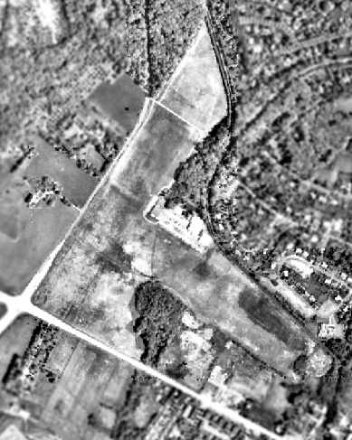
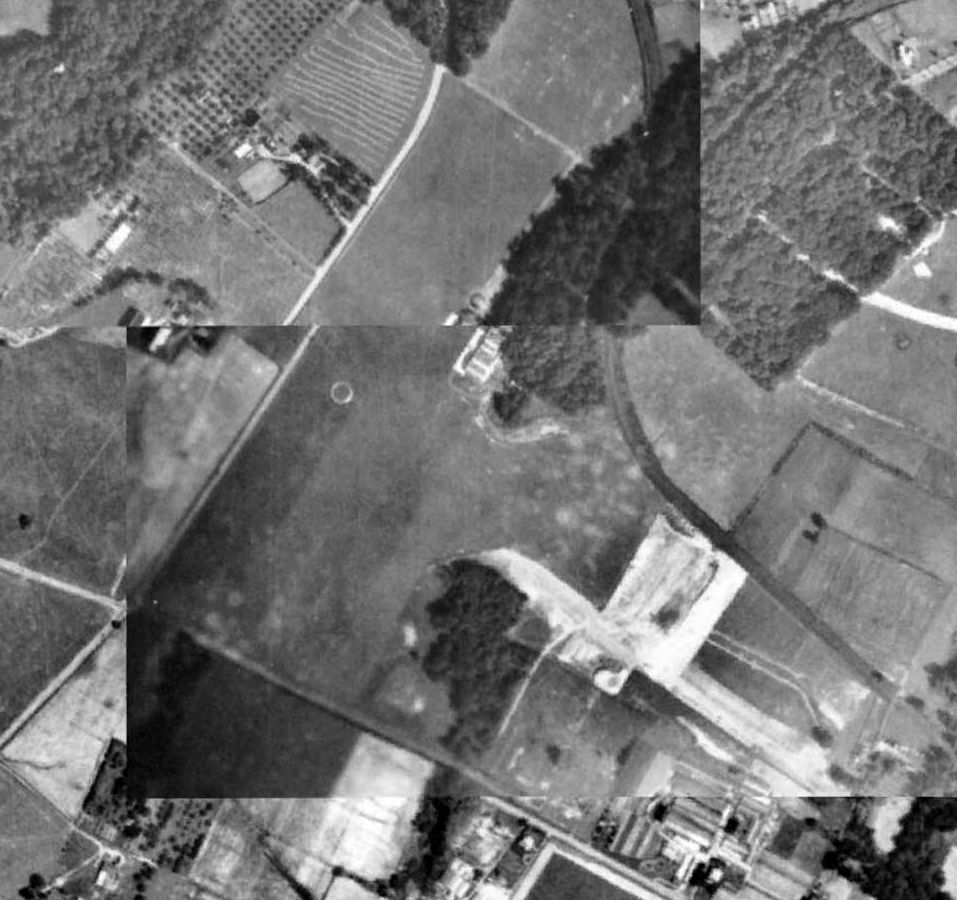
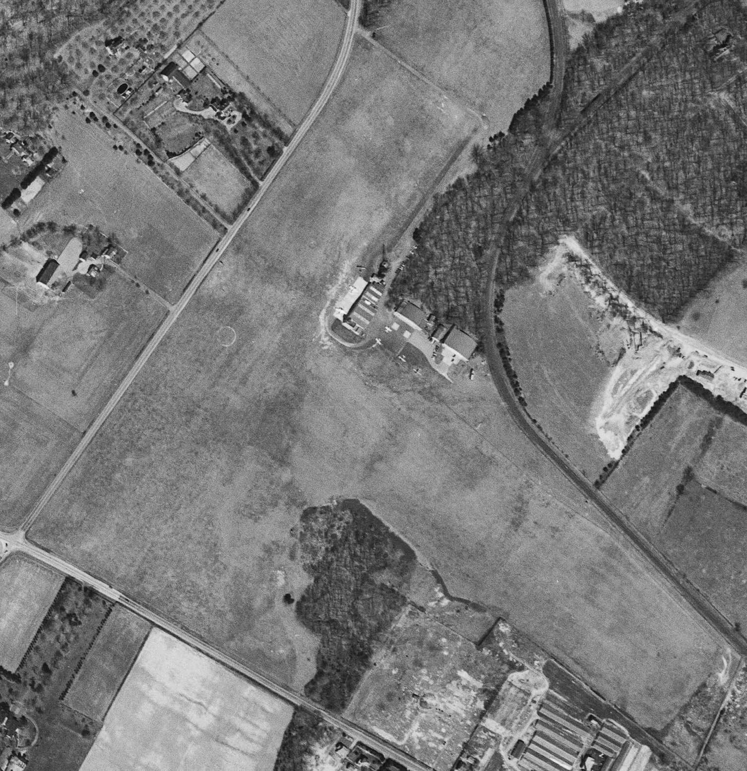
The last depiction which is available showing the Du Pont Airport before it was redeveloped was a 1968 aerial photo.
The 2 grass runways were still intact, as well as the hangars & other airport buildings in the center of the photo.
Jim Fairweather recalled, “I can remember as a child in the late 1960s, passing the DuPont Airport.
All American Engineering was painted on the front of the hangars.
There were either S-55 or S-58 Sikorskys on the ramp at times.”
According to Bob Veazey, “AAE moved to S. Market Street near the present Blue Rocks Park in 1969.
I was Project Manager of the CH-3 Program & Manager of Aerial Recovery Programs
from 1969 until the company merged with another in 1989.”
A 1970 aerial photo did not show any aircraft at DuPont Airport.
According to Mike Denest, "In the early 1970s, the Delaware radio controlled model club
sponsored glider contests on the site prior to it being developed into an office park.
It was a great place to fly, with plenty of room & thermals galore."
Dan Frederick recalled, “Du Pont Airport... I witnessed the removal of the control tower in the spring of 1983.”
At some point between 1983-92, the Du Pont Airport property was redeveloped by the DuPont company into the Barley Mill corporate park,
with multiple office buildings being built over the site, as was shown on a 1992 USGS aerial view.
In 2003, the Delaware Public Archives & the Delaware Aviation Hall of Fame
dedicated a state historical marker at the former location of the DuPont Airfield.
A flyover was planned by some dozen aircraft during the dedication ceremony
following the route taken by Charles Lindbergh when he flew to the airfield.
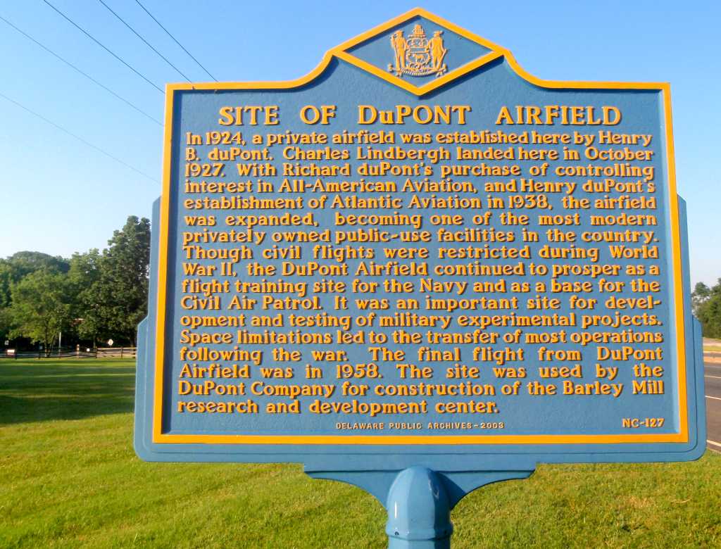
A 6/25/11 photo by Stephen Duncan (courtesy of Keith Smith) of the historical marker commemorating the site of DuPont Airport.
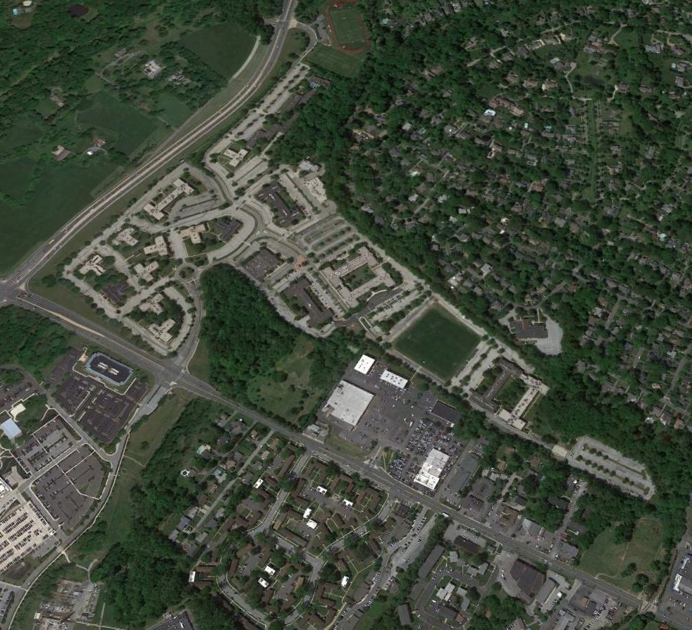
A 2016 aerial view looking north shows not a trace remains of Du Pont Airport.
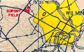
The site of DuPont Airport is located east of the intersection of Centre Road & Lancaster Pike.
Thanks to Tom Miller for pointing out the correct location of the airport site.
____________________________________________________
Or if you prefer to contact me directly concerning a contribution (for a mailing address to send a check),
please contact me at: paulandterryfreeman@gmail.com
If you enjoy this web site, please support it with a financial contribution.
____________________________________________________
This site covers airfields in all 50 states.