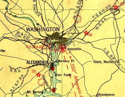
Abandoned & Little-Known Airfields:
Washington, DC
© 2002, © 2026 by Paul Freeman. Revised 2/15/26.
This site covers airfields in all 50 states: Click here for the site's main menu.
____________________________________________________
Please consider a financial contribution to support the continued growth & operation of this site.
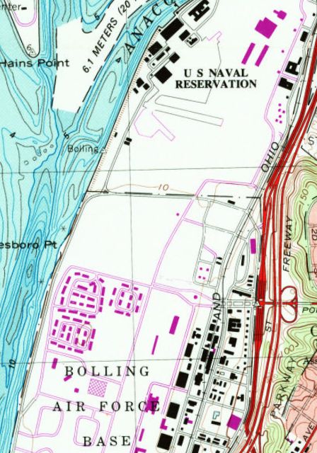
Anacostia NAS (revised 10/29/25) - Bolling Field / Bolling AFB (revised 2/15/26)
____________________________________________________
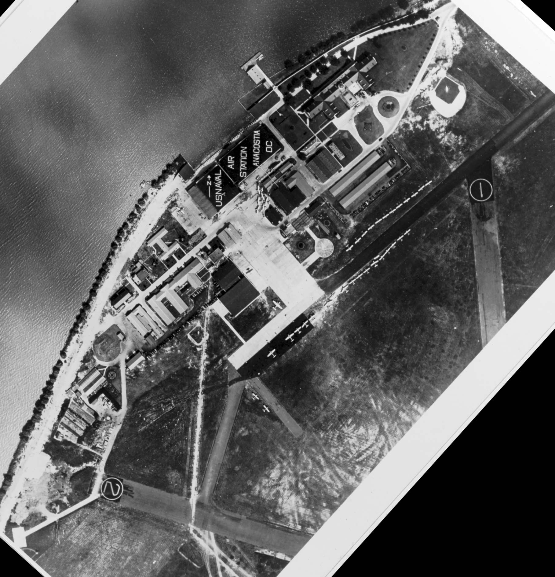
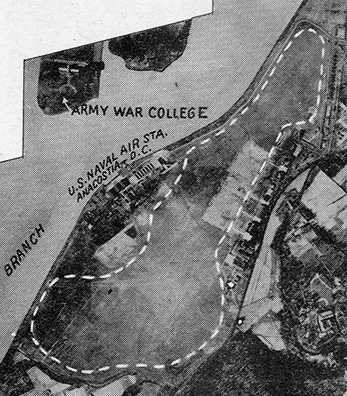
Anacostia Naval Air Station, Anacostia, DC
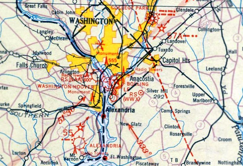
38.854, -77.013 (Southeast of Capitol Hill, DC)
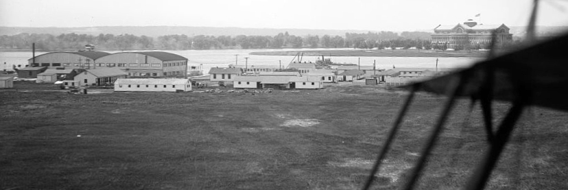
A 1919 aerial view (courtesy of the Library of Congress) looking east at the seaplane hangars along the west side of Naval Air Station Anacostia.
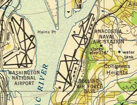
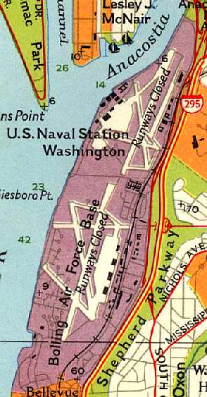
The narrow plain along the eastern bank of the Anacostia River originally contained 2 military airfields:
the Navy's Anacostia Naval Air Station & the Army's Bolling Field.
Anacostia NAS got its start in 1917, when the War Department authorized the Navy to use the Anacostia Flats,
a drained swamp area, as a seaplane base.
Land plane facilities were added in 1918, starting with 2 runways & 2 hangars, which were to be shared with the Army.
The earliest depiction which has been located of Naval Air Station Anacostia was a 1919 aerial view (courtesy of the Library of Congress) looking east at the seaplane hangars along the west side.
A 1920 Library of Congress aerial view of Naval Air Station Anacostia, showing 2 or 3 seaplanes in front of 2 hangars.
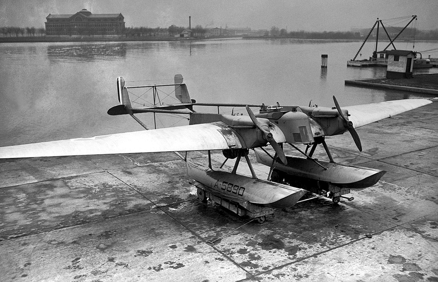
A 1/18/22 photo of the sole Navy Curtiss CT-1, A-5890, a twin-boom bomber floatplane, at Naval Air Station Anacostia, with Roosevelt Hall visible across the river.
after a record-setting flight of 4 days from San Domingo.
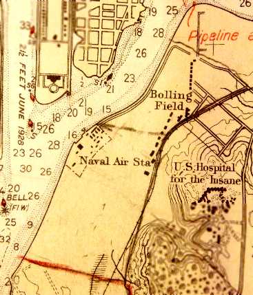
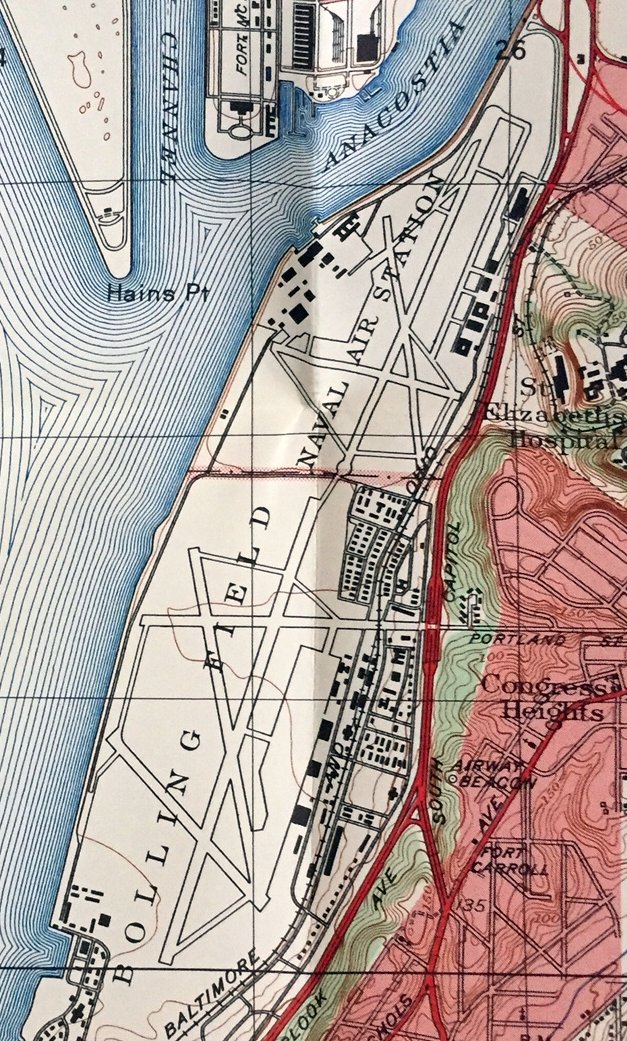
The 1926 USGS topo map (courtesy of Laurence Burke) depicted the “Naval Air Station” Anacostia as having several buildings along the west side of the field,
with “Bolling Field” located to the northeast.
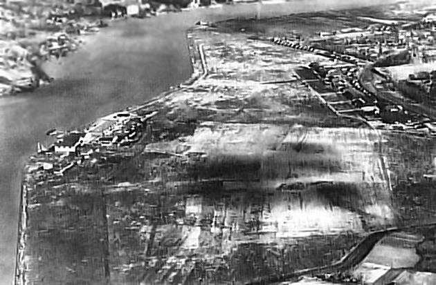
A mid-1920s aerial view looking north at Anacostia NAS,
showing the airfield as a large open grass area, with several hangars along the west side.
The hangars of Bolling Field were along the east side (at top-right).
The 1927 Department of Commerce Airway Bulletin (courtesy of David Brooks)
depicted an unusual layout of “Bolling Field” occupying the majority of the site,
with the “U.S. Naval Air Station” occupying a small cutout along the river on the west side.
According to United States Naval Aviation 1910-1995 (courtesy of David Collier),
“A flight test section was established as a separate department at NAS Anacostia with Lt. George Henderson in charge” on 1/1/27.
A 1929 street map (courtesy of Kevin Walsh) depicted Anacostia “Naval Air Station” along with “Bolling Field” to the north.
Charles & Anne Lindbergh, stopping in their Lockheed Sirius in 1931 at NAS Anacostia,
as they prepare to embark on a 7,000 mile trip scouting new airline routes to Tokyo.
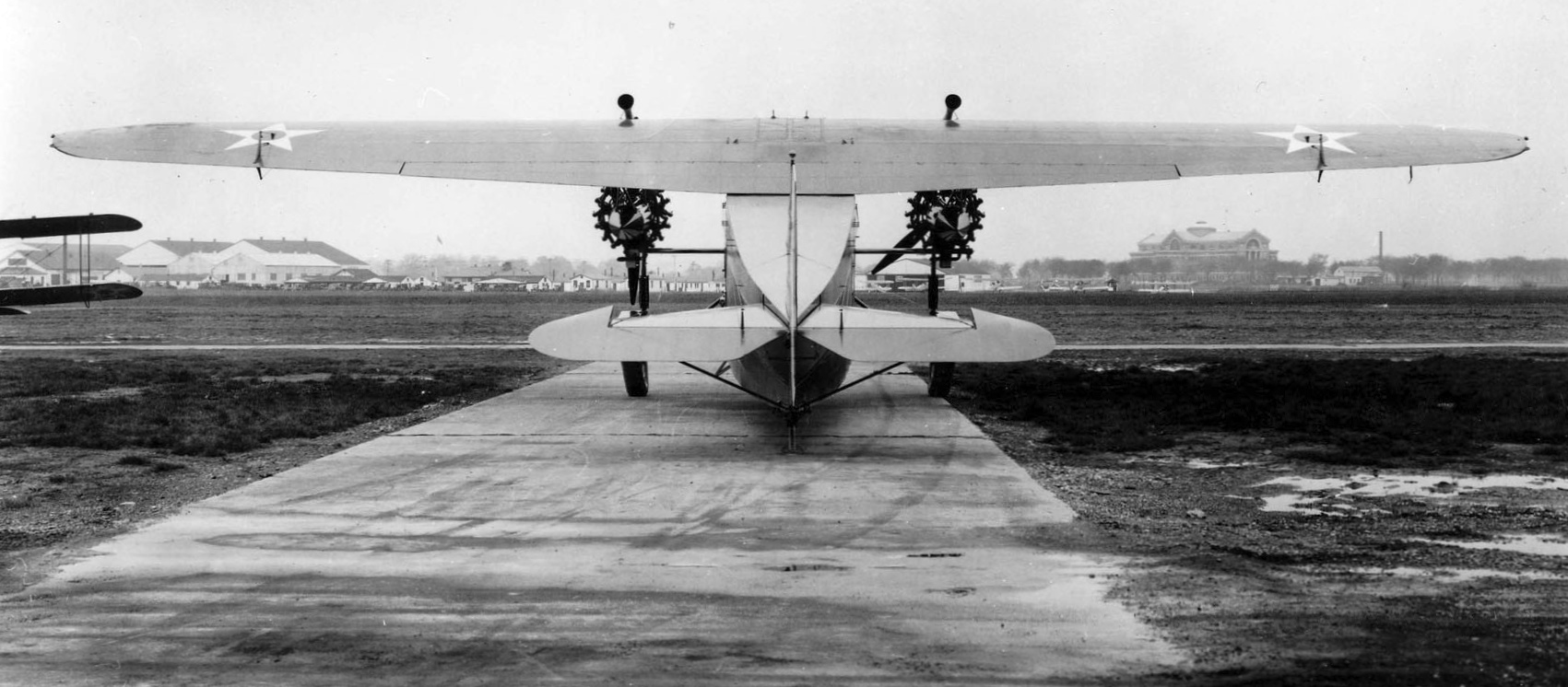
Bolling Field, as depicted on the May 1932 Washington Sectional Chart.
A 4/23/32 aerial view looking northeast at Bolling Field, with NAS Anacostia in the background.
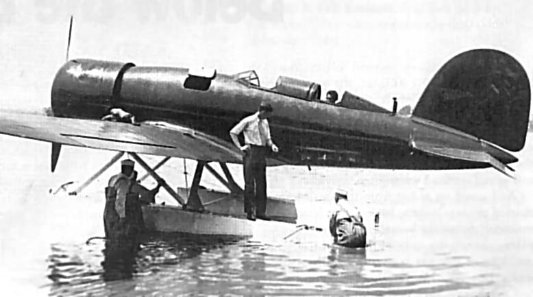
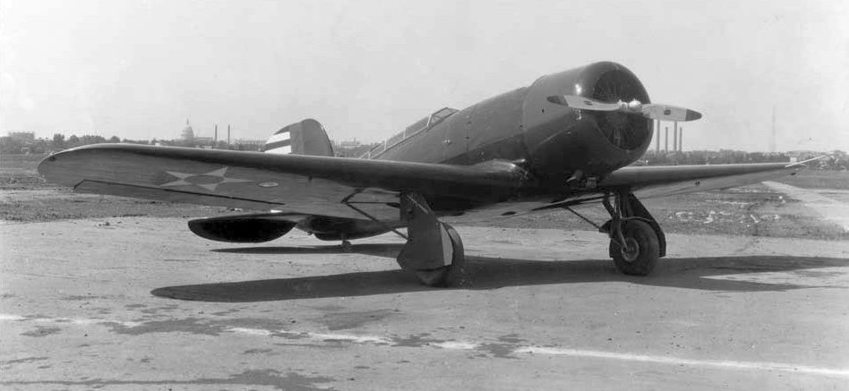
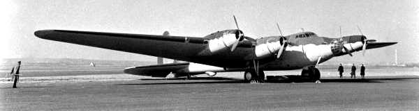
A 6/22/33 photo of the sole prototype of the XFD-1 at Anacostia Field.
The XFD-1 was the very first fighter to be produced by Douglas, but did not go on to see production.
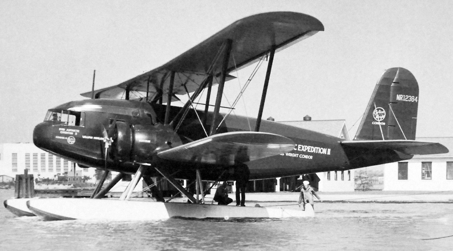
A September-October 1933 photo of the William Horlick, Curtiss T-32 Condor II, NR 12384, C/n 41, seen at NAS Anacostia.
It was subsequently used by Richard Byrd's 2nd Antarctic Expedition.
Anacostia was described in the Commerce Department's 1934 "Descriptions of Airports & Landing Fields in the U.S." (courtesy of Chris Kennedy)
as using the landplane facilities of Bolling Field, which were said to comprise a 7,000' x 2,000' sod landing area.
"Bolling Field Naval Air Station", as depicted on the 1934 Navy Aeronautical Chart (courtesy of Chris Kennedy).
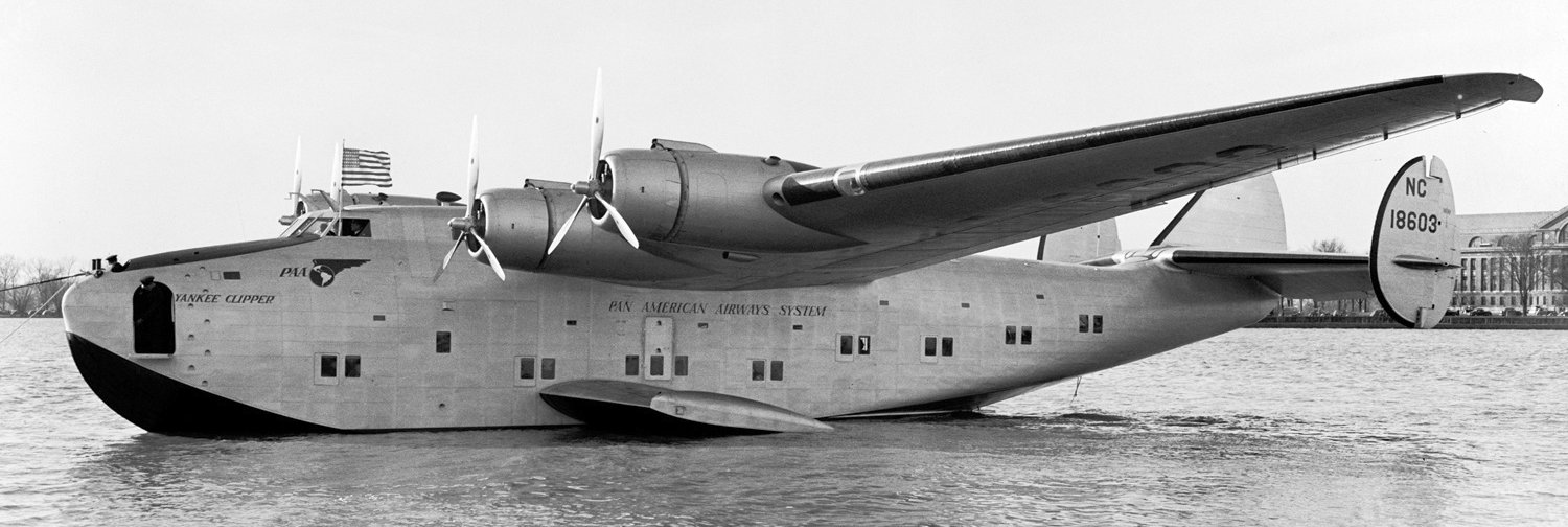
A 3/3/39 photo of Pan Am Yankee Clipper, Boeing 314 NC18603, C/n 1990, at NAS Anacostia, shortly after being christened by Eleanor Roosevelt.
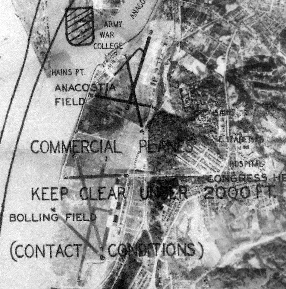
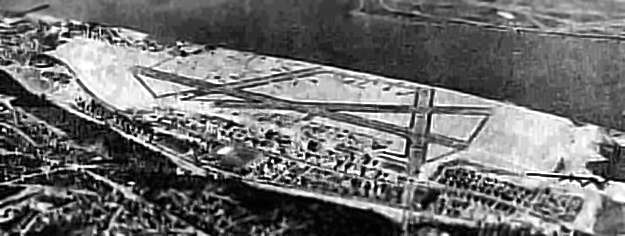
An undated aerial view from a November 1939 depiction of Washington Restricted Areas (from the Philadelphia National Archives, courtesy of Ron Plante) depicted Anacostia Field as having 3 runways.
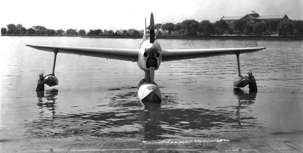
A 6/6/41 photo of a rare Navy Curtiss XSO3C-1 prototype, BuNo 1385, being brought back onto land at NAS Anacostia.
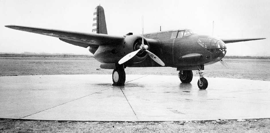
A 1941 Navy photo of a rare Navy BD-1, an XF-3 (photographic reconnaissance version of the A-20 Havoc bomber) acquired from the Army Air Force for evaluation,
pictured during flight testing at NAS Anacostia.
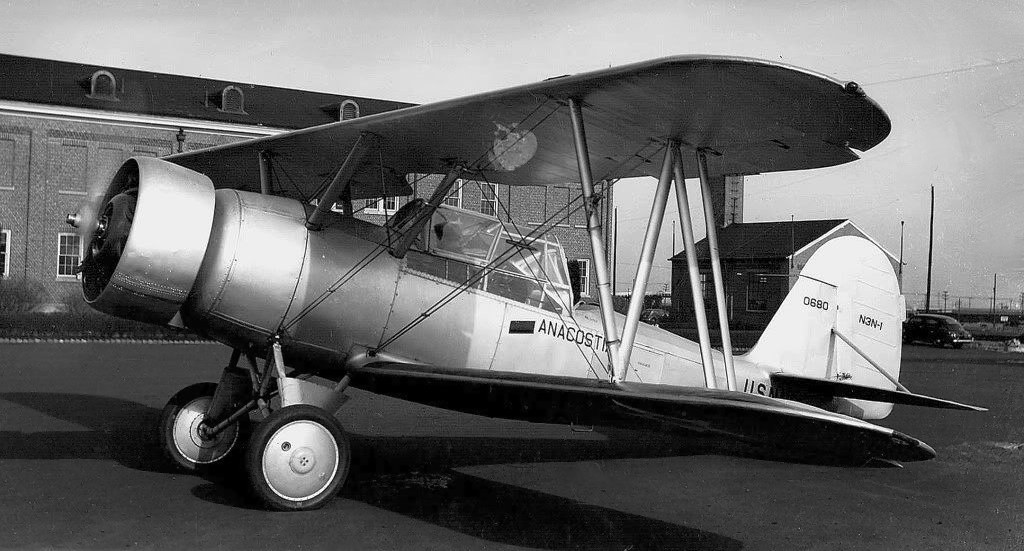
An undated photo of a Naval Air Facility N3N-1 biplane maked “Anacostia” & assigned to flight test duties at the base, featuring an unusual (perhaps unique) enclosed cockpit canopy.
David Collier reported, “In late 1941 the Reserves at Anacostia had 11 Naval Aircraft Factory N3N-3 primary trainers assigned to them.”
During WW2, Anacostia expanded considerably & became a primary training base for naval aviation.
It was at this point when the base evidently gained its paved runways.
A circa 1942-43 photo (courtesy of Dave Collier) which Dave Collier noted as Anacostia's “Northern-most hangar which was installed by the Air Corps.
This hangar was a prefab brought from France as a payment of their war debt to the US.
The U.S. insignia on the trainers [Naval Aircraft Factory N3N-3 biplanes] was authorized from 5/18/42-6/28/43.
The photo was taken looking south. The steam generator at the right is in the aircraft wash rack area.
When AD Skyraider aircraft were delivered the hangar floor was removed,
the area dug out to a depth of 2-3' & the floor was replaced with ramps at the hangar doors.
This project allowed tail clearance for the new aircraft.”
Overcrowding at Anacostia caused Navy Flight Test operations to be moved in 1943 to nearby NAS Patuxent River.
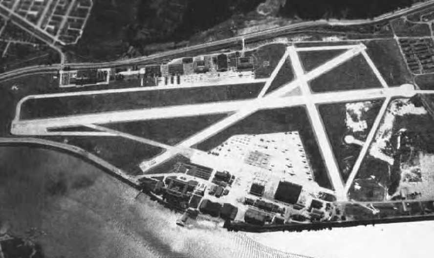
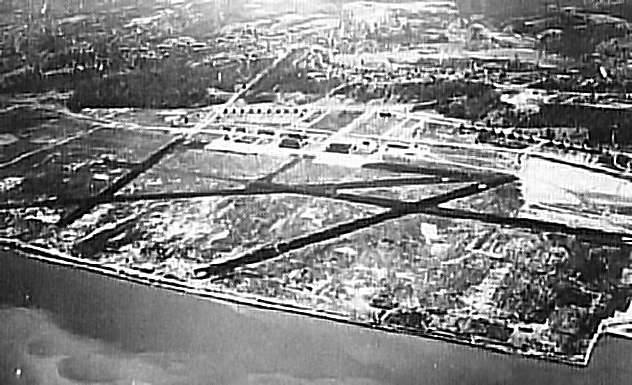
A 7/10/44 US Navy aerial view looking north at Bolling Field (bottom-center) & NAS Anacostia (upper-right). Note the taxiway connecting the 2 airfields.
A WW2-era aerial view looking northwest at Anacostia NAS,
with the runways of Bolling AFB just visible to the left (National Archives photo).
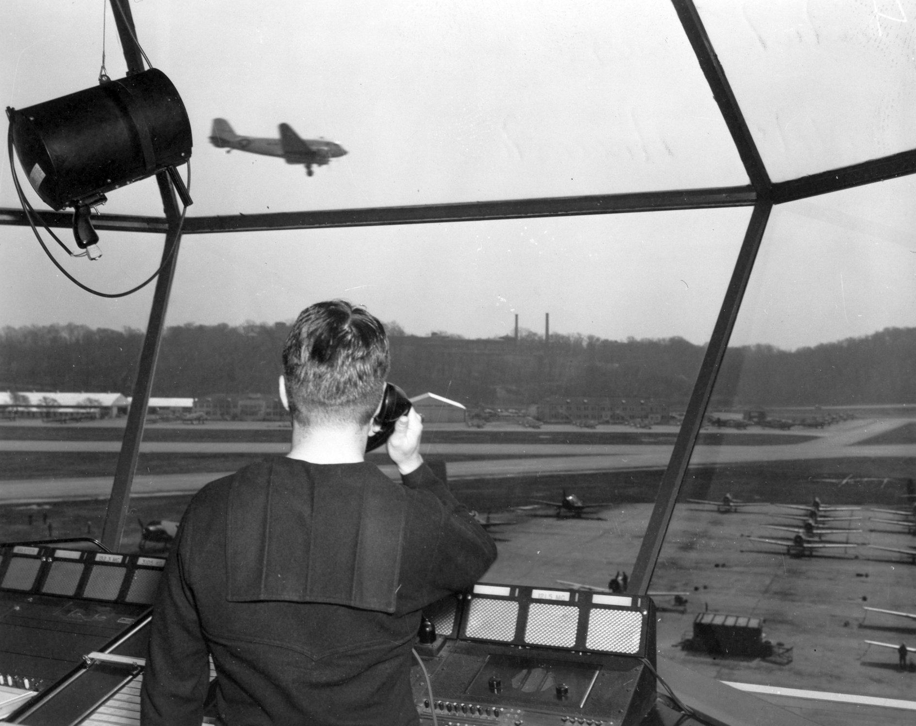
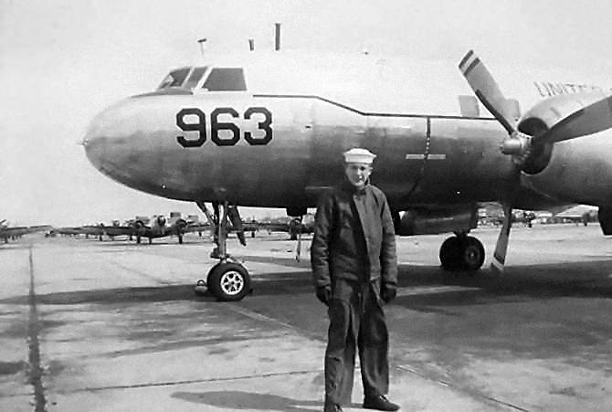
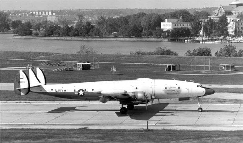
A 1950s USN photo of a Douglas R4D seen landing from inside the Anacostia Field control tower.
Anacostia had one Outlying Landing Field, at Beltsville, Md.
The 1945 AAF Airfield Directory (courtesy of Scott Murdock)
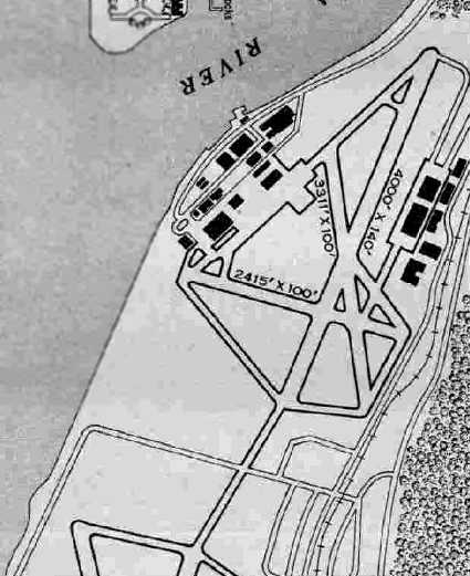
depicted Anacostia NAS as a 302 acre irregularly-shaped property within which were 3 asphalt runways, the longest being a 4,000' northeast/southwest strip.
The field was said to have 5 steel & concrete hangars, with the largest measuring 240' x 185'.
Anacostia was said to have 2 Outlying Fields: Beltsville Outlying Field & Hybla Valley Outlying Field.
The primary runway at Anacostia was expanded to 5,005' in 1945 for use by the Naval Air Reserves.
All of Anacostia NAS & Bolling AAF were depicted as an empty “Military Reservation” on 1940s maps,
without depicting any runways or any other details,
presumably due to wartime security concerns.
The April 1947 Washington Sectional Chart depicted NAS Anacostia as having a 5,000' paved runway.
An undated aerial view looking east at Anacostia from the November 1947 Naval Aviation News
showed a large number of aircraft on the west ramp,
as well as the main runway which had been lengthened to the north.
Anacostia NAS & Bolling AFB, as depicted on the 1949 USAF Target Complex Chart.
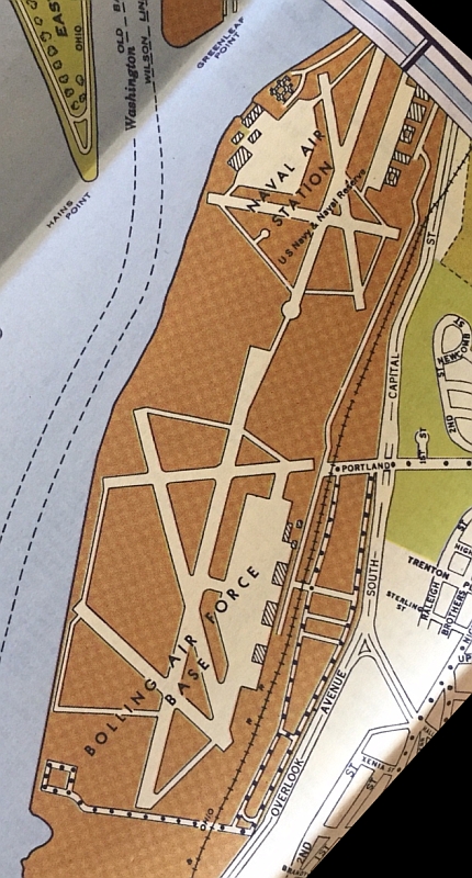
Anacostia NAS & Bolling AFB, as depicted on a 1952 street map (courtesy of Kevin Walsh).
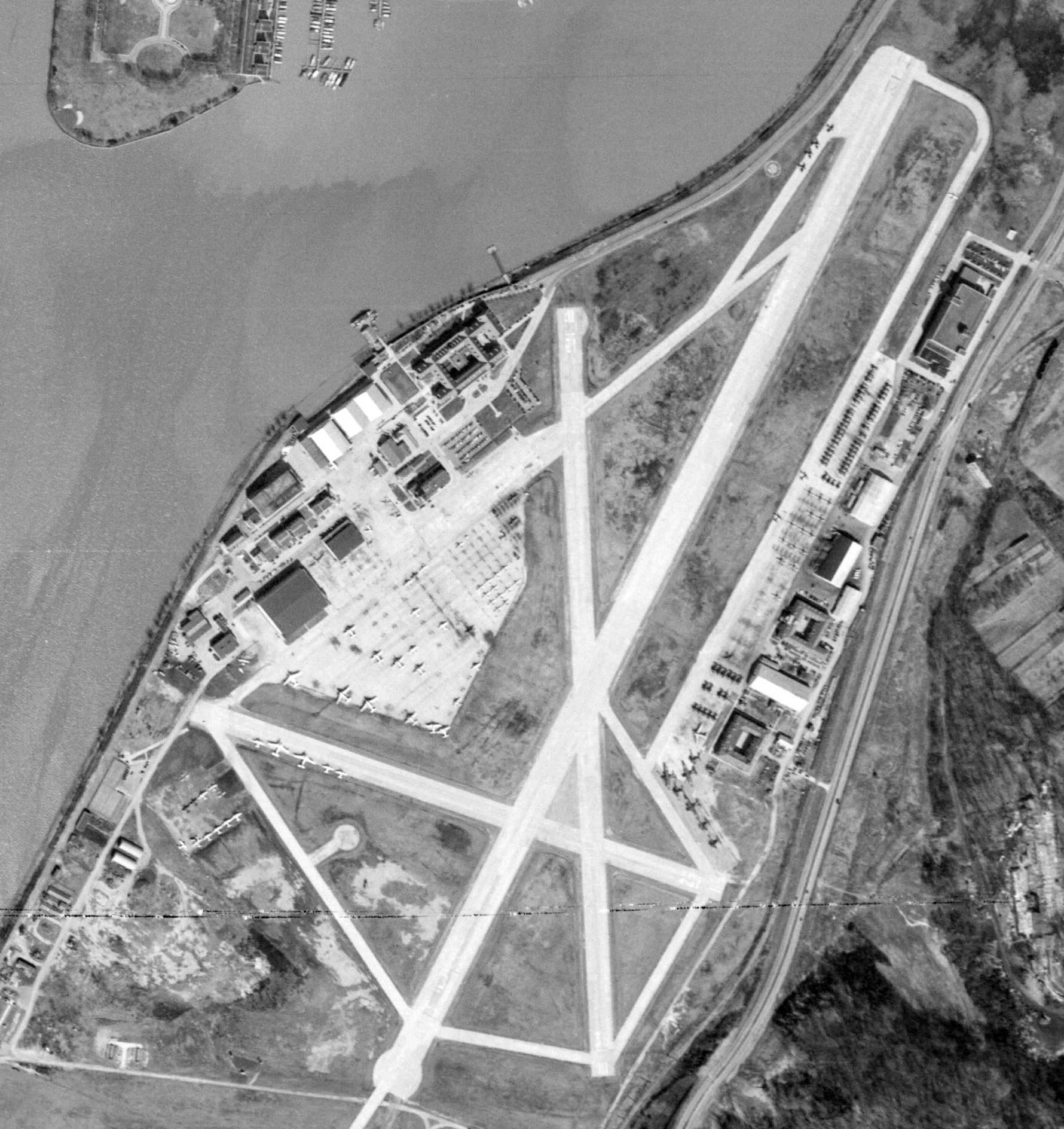
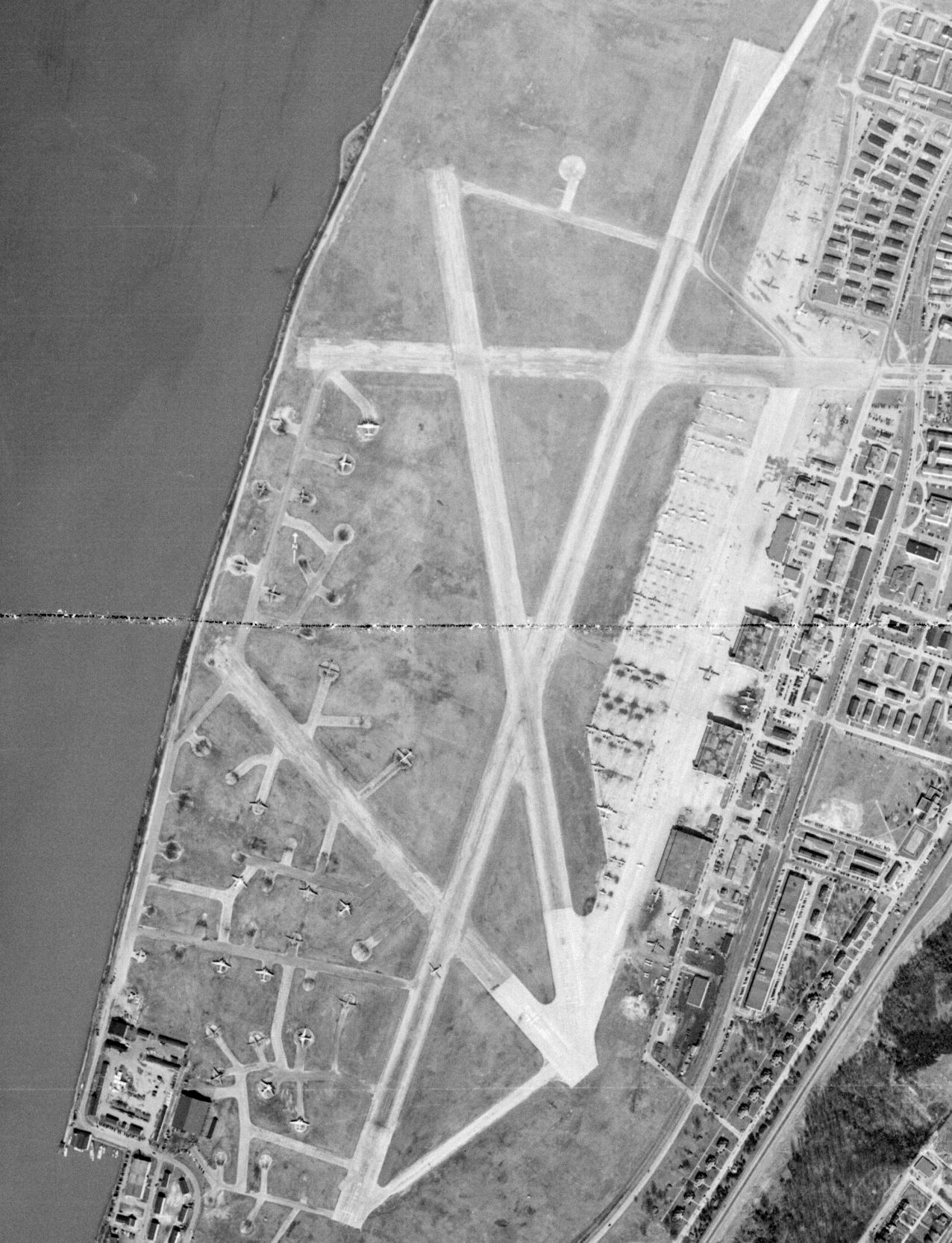
A 3/4/49 USGS aerial view of NAS Anacostia, showing an amazing number of aircraft parked on the east & west sides of the field.
According to David Collier, the main features on the Reserve side of the field (the east side)
were (north-to-south): the Naval Photographic Center, VF flightline, AC wash pad, VF hangar,
VS flightline, VS hangar, Operations/Administration, VP hangar, barracks, and VP flightline.
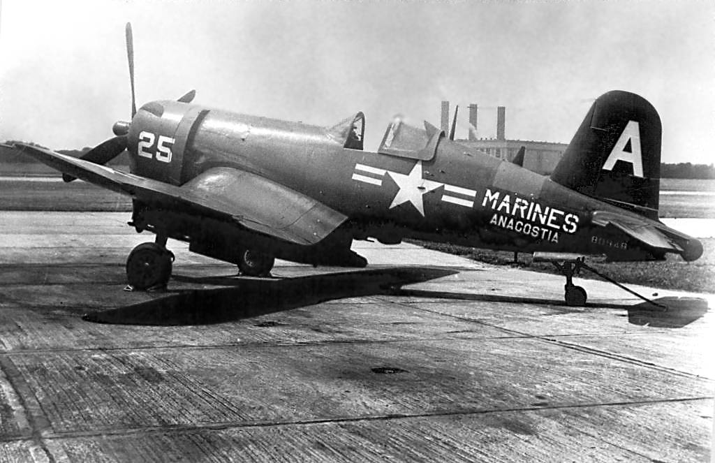
A late 1954 – early 1955 photo of a Marine Corps Reserve Vought F4U-4 Corsair (BuNo 80948) of VMF-321 at NAS Anacostia.
David Collier noted, “This aircraft's markings had an interesting history.
VMF-321 did their active duty training in August 1954 at MCAS El Toro.
During that period one of their Corsairs had engine trouble which called for the replacement of its carburetor.
For either reasons of replacement parts cost or the time required to complete the repairs,
the aircraft was swapped for a F4U-4 assigned to a Headquarters & Maintenance Squadron at El Toro.
That squadron's aircraft displayed a 2-letter Tail Code with the second letter being an 'A'.
Our squadron painted over the first letter & flew the plane home to Anacostia.
All NARTU aircraft carried NAVY markings with aircraft maintained by the Marines identified by a red prop hub.
This aircraft was the pride of the Marines because of its MARINE marking & many photos were taken before it was repainted with NAVY markings.”
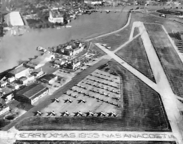
A 1955 aerial view looking north at NAS Anacostia, with “Merry Xmas 1955 NAS Anacostia” spelled out on the east/west runway (courtesy of Richard Weckman).
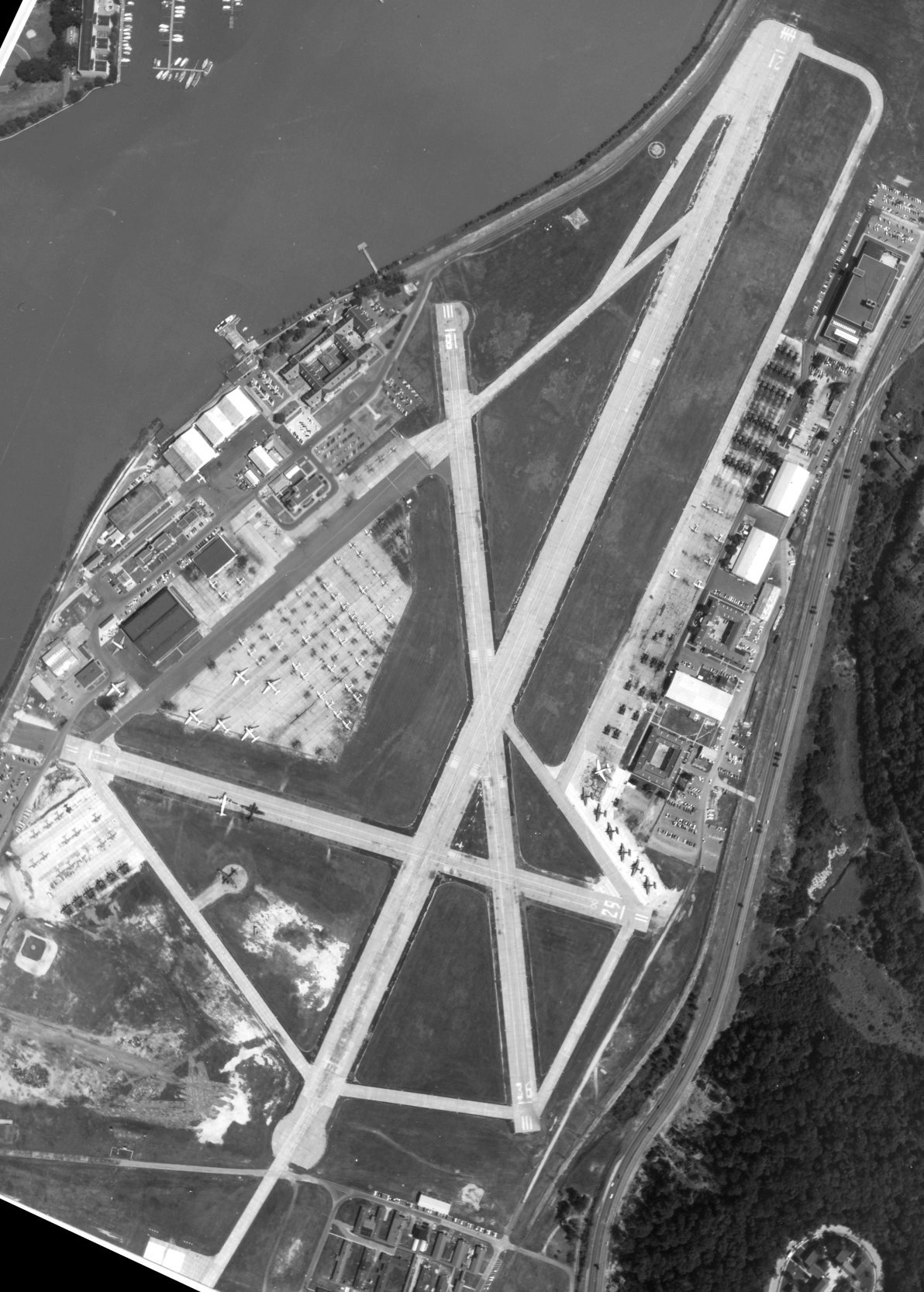
A 6/24/55 aerial view of NAS Anacostia (from the National Archives, courtesy of Michael Binder).
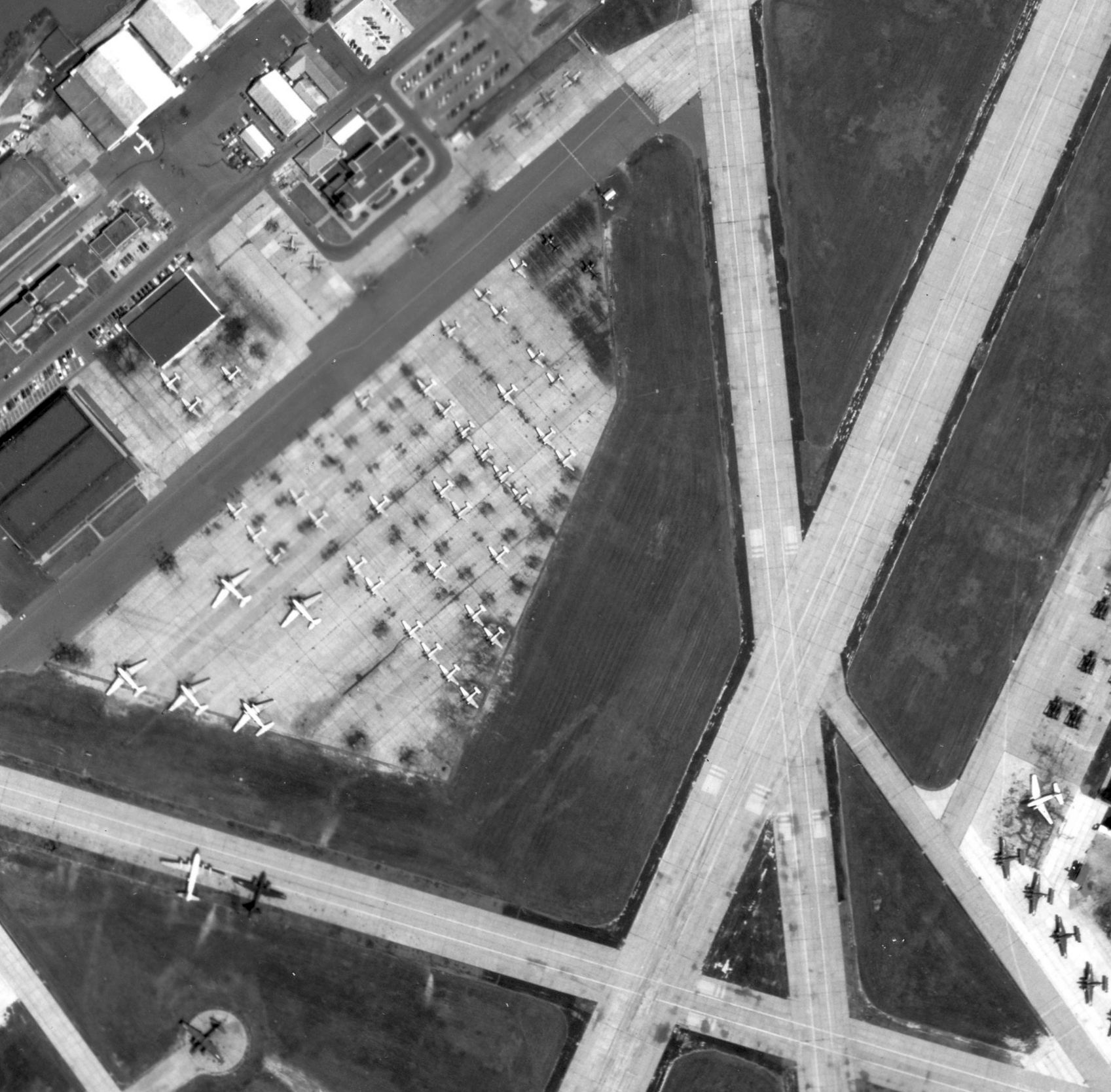
A closeup of the NAS Anacostia west ramp from the 6/24/55 aerial view (from the National Archives, courtesy of Michael Binder).
Michael Binder observed, “What's of most interest is the trapezoidal ramp hosting all those fixed-wing airplanes which became the helicopter alert site 3 years later.
I still don't know where the Navy put all those airplanes before they moved to Andrews in 1962.”
A mid- to late-1950s photo by Lester Lemar of several aircraft on the ramp at Anacostia.
A mid- to late-1950s photo by Lester Lemar of C.W. Wolf in front of a Convair R4Y & several other aircraft on the ramp at Anacostia.
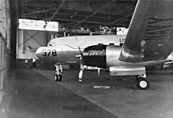
A mid- to late-1950s photo by Lester Lemar of a Convair R4Y inside a hangar at Anacostia.
Lester recalled, “We were told that this aircraft was used by the Secretary of the Navy for him to relax on.
I know when I had to do work on the plane I had to wear footies that were provided.”
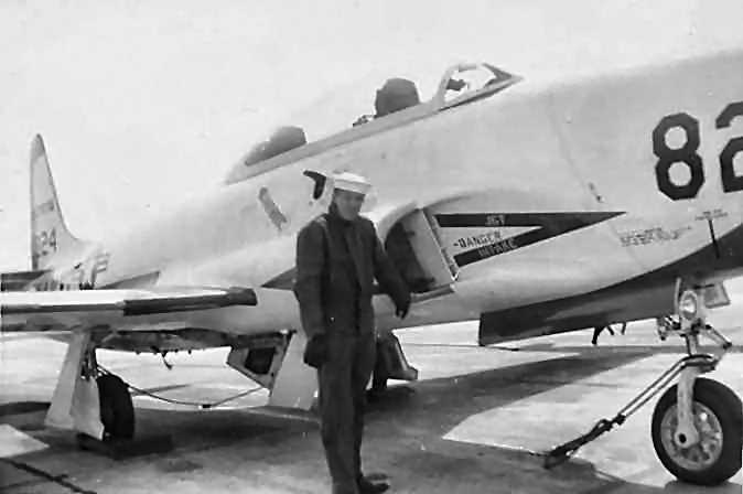
A mid- to late-1950s photo by Lester Lemar of C.W. Wolf in front of a Lockheed TV-2 Shooting Star at Anacostia.
Richard Weckman recalled, “NAS Anacostia... I was stationed at here from 1955-57, and was the supervisor of the radio shack at the time.
Our call sign was NSF. I have fond memories of this place.
We hosted the Gold Cup races. The Sequoia [Presidential yacht], and the Secretary of the Navy's T-28 was there.”
The July 1956 Washington Local Aeronautical Chart (courtesy of Tim Zukas)
depicted Anacostia as having 3 paved runways, with the longest being 5,000'.
According to Michael Jacobson (who was stationed at Anacostia from 1956-58 in HQ Marine Corps Flight Section),
"We maintained an assortment of aircraft for the pilots at HQ to get their flight skins in each month.
The Commandant's R5D was part of the squadron, and we had some R4Ds, numerous SNB-5s, a few TV-2s & AD-5s.
Our most notable pilot was Major John Glenn, who later became an astronaut & senator.
We were not allowed to have cameras on base, and as a result, none of us have photos of each other or of the base."
A 1957 aerial view of the large number of small & large aircraft parked on the ramps on the east & west sides of Anacostia.
Anacostia operated jet aircraft (Lockheed TV-2 trainers) for a brief period, starting in 1957.
A 1958 Army Map Service map (courtesy of Kevin Walsh) depicted Naval Air Station Anacostia as having 4 paved runways.
A circa 1959-61 photo (courtesy of Dave Collier) of a Lockheed P2V Neptune in front of Anacostia's Reserve barracks.
The last photo which has been located of a fixed-wing aircraft at NAS Anacostia was a 11/11/59 Naval Historical Center photo
of a Lockheed WV-2 (BuNo 126513) from FASRON 102, nicknamed "El Paisano",
on the Anacostia runway as it prepared for the 1st round-the-world "Project Magnet" mission.
The last photo which has been located showing the runways of NAS Anacostia remaining intact was a 1/24/60 USAF aerial view (courtesy of Dallam Oliver-Lee),
which also showed Bolling AFB at the bottom.
The last aeronautical chart depiction which has been located showing NAS Anacostia still open was on the July 1960 Washington Sectional Chart.
It depicted Anacostia as having 3 paved runways, with the longest being 5,000'.
But the remarks on the Aerodromes table said "Closed to jet operations.”
The end of fixed-wing flying operations at both Anacostia NAS & Bolling AFB was brought about by 2 factors.
The first was the advent of the jet aircraft, which necessitated much longer runways
than could be accommodated in the constricted patch of ground along the Anacostia River
(the two bases are also bordered on the east side by the I-295 expressway, which precluded any property expansion eastward).
The second factor making the closure unavoidable was the presence of Washington National Airport directly across the Anacostia River,
only a mere mile away from the 2 military airfields.
National has evolved into one of the busiest airports in the world, blanketing the area over Anacostia with extremely dense commercial air traffic.
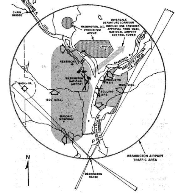
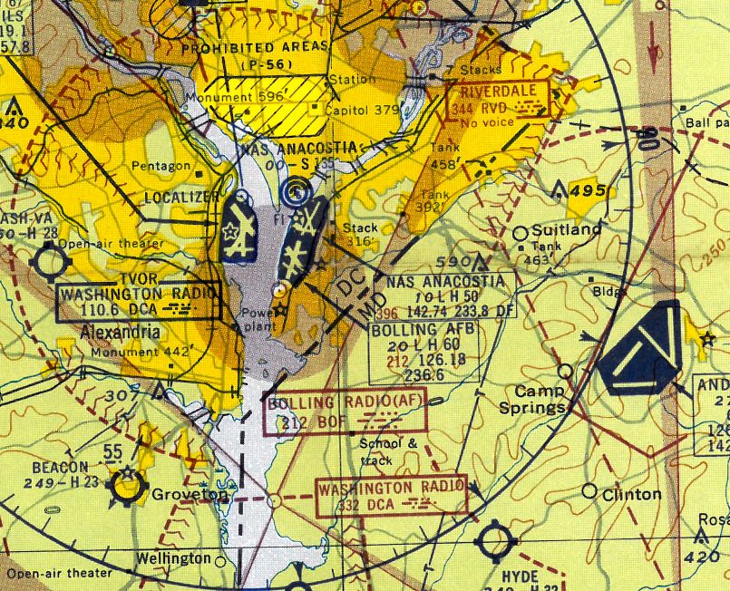
A 1961 diagram of the Washington Airport Traffic Area displayed an “Anacostia/Bolling VFR Corridor”.
Doug Megill reported, the “last navy plane out of NAS Anacostia... there was a picture on the front page of the Washington Star newspaper
of my dad Henry Megill captioned with 'Last plane out' when he flew the last plane of his Reserve squadron out & over to Andrews [AFB].”
The runways at Anacostia & Bolling were closed to fixed wing traffic in 1962,
as both Navy & Air Force fixed wing flying operations for the Washington DC area moved
to the much larger & less constrained Andrews AFB a few miles to the East.
The only aircraft visible on all of Anacostia NAS in a 1963 aerial photo were 7 helicopters (possibly H-34s) parked on the ramp on the west side of the field.
The airfield & all of its facilities remained otherwise intact.
The runways of both NAS Anacostia & Bolling AFB were still depicted
on the 1964 National Geographic Map of Suburban Washington (courtesy of David Brooks),
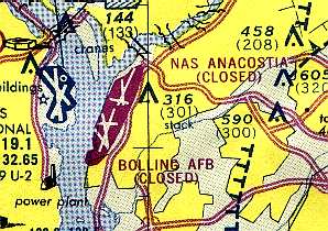
but both airfields were labeled "Runways Closed".
NAS Anacostia was depicted as closed on the April 1965 Washington Sectional Chart.
The runways of both NAS Anacostia & Bolling AFB were still depicted
on the 1975 Washington Terminal Area Chart (courtesy of Ed Drury),
but both airfields were labeled "Closed".
A 1976 DOT street map (courtesy of Kevin Walsh) showed the relatively small Anacostia NAF helicopter facility, in place of the previous runways.
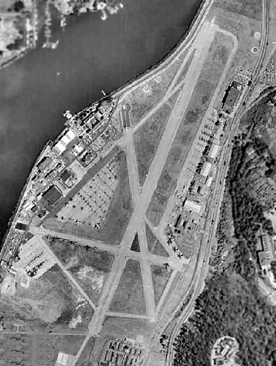
Most of the Anacostia runways had been removed by the time of a 1980 aerial photo, with the exception of the east/west runway.
A January 1981 DOS aerial view of Anacostia NAS,
showing 3 VH-3 helicopters in the center, and a single H-1 helicopter on the former runway segment to the lower-left.
The 1983 USGS topo map depicted the hangars & remaining short runway segments at the Anacostia heliport.
A circa 1980s aerial view of looking northwest at Anacostia NAS (courtesy of George Miller),
showing 3 VH-3 helicopters of Presidential Squadron HMX-1 parked on the ramp,
and several vintage hangars in the background.
An April 1988 aerial view looking northwest at the NAS Anacostia helicopter facility (courtesy of Michael Binder)
showed 2 VH-3 helicopters parked to the southeast of the hangar.
At some point in 1989-90 a new helicopter hangar, control tower, and concrete ramp were built in the center of the original Anacostia airfield area,
as indicated in a 2014 NAS Anacostia master plan (courtesy of Micheal Binder).
A January 1991 DOS aerial view looking southeast showed the new helicopter hangar, control tower, and concrete ramp which had been built in the center of the original Anacostia airfield area.
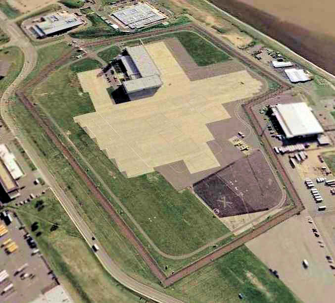
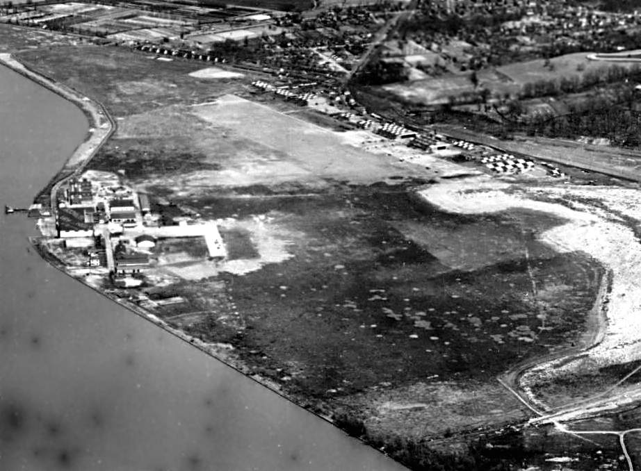
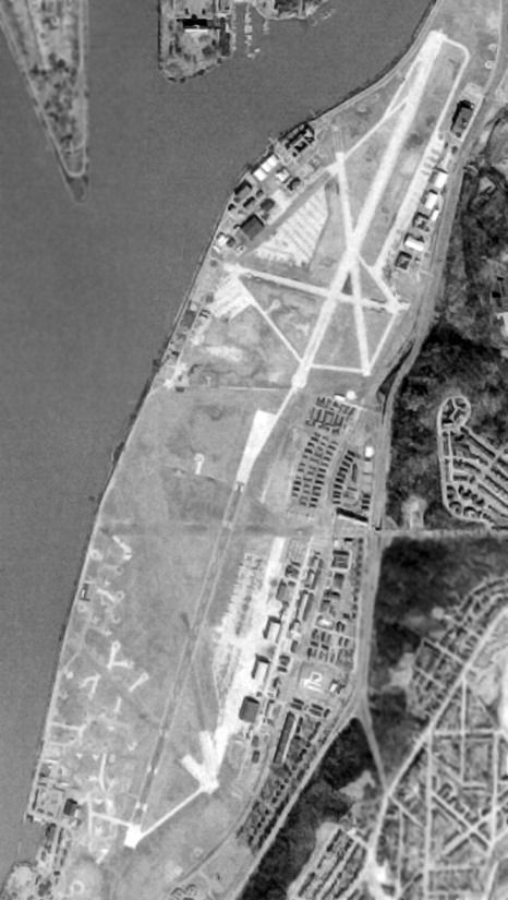
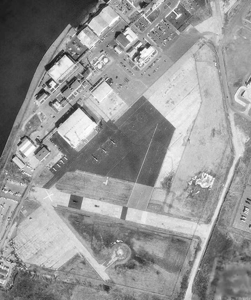
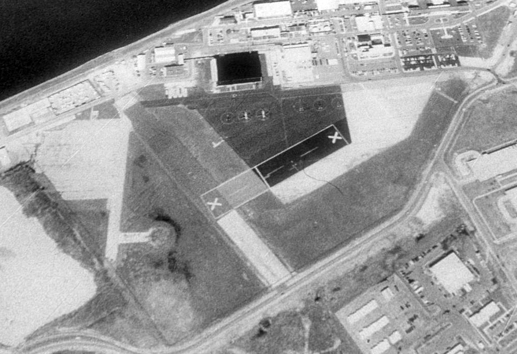
A 2002 USGS aerial photo looking southwest at the hangar & helicopter ramp area at Anacostia NAF.
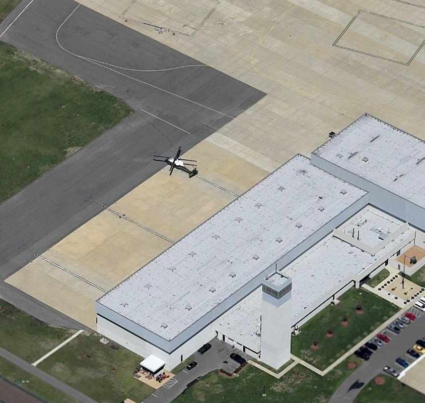
A circa 2005 aerial photo looking northwest at a Sikorsky VH-60 Executive Hawk on the Anacostia NAF ramp,
with the control tower in the foreground.
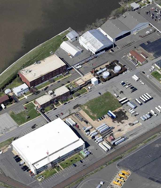
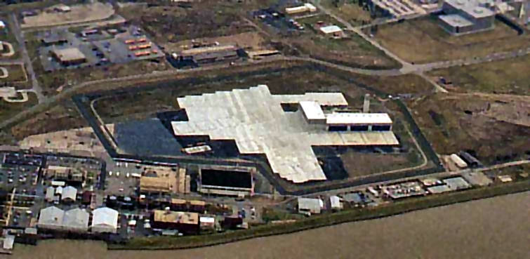
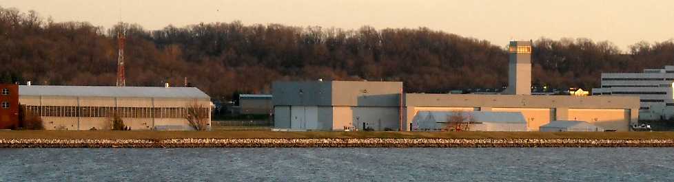
A circa 2005 aerial photo looking northwest at several former hangars at Anacostia NAF.
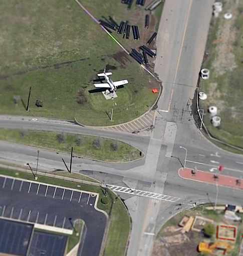
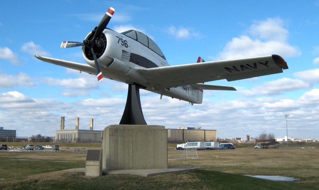
A circa 2005 aerial view looking north at what appears to be the only remaining fixed-wing aircraft at NAS Anacostia:
a North American T-28 Trojan, mounted on a pylon next to the main entrance to the base.
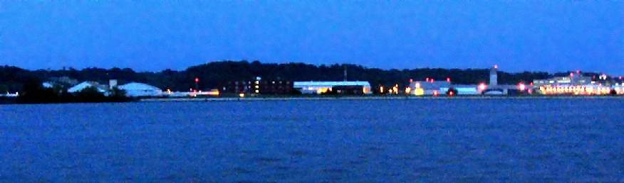
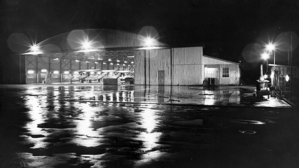
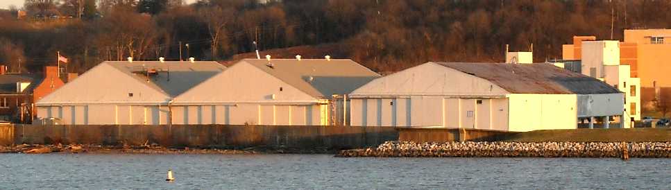
A nighttime 2006 photo by Paul Freeman, looking east at the former hangars & control tower which remain at Anacostia.
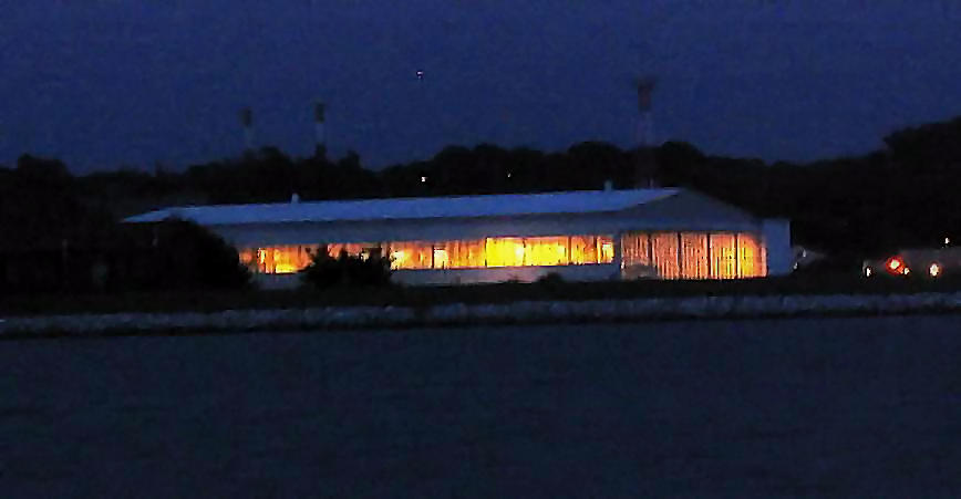
A nighttime 2006 photo by Paul Freeman, looking east at a former Anacostia hangar.
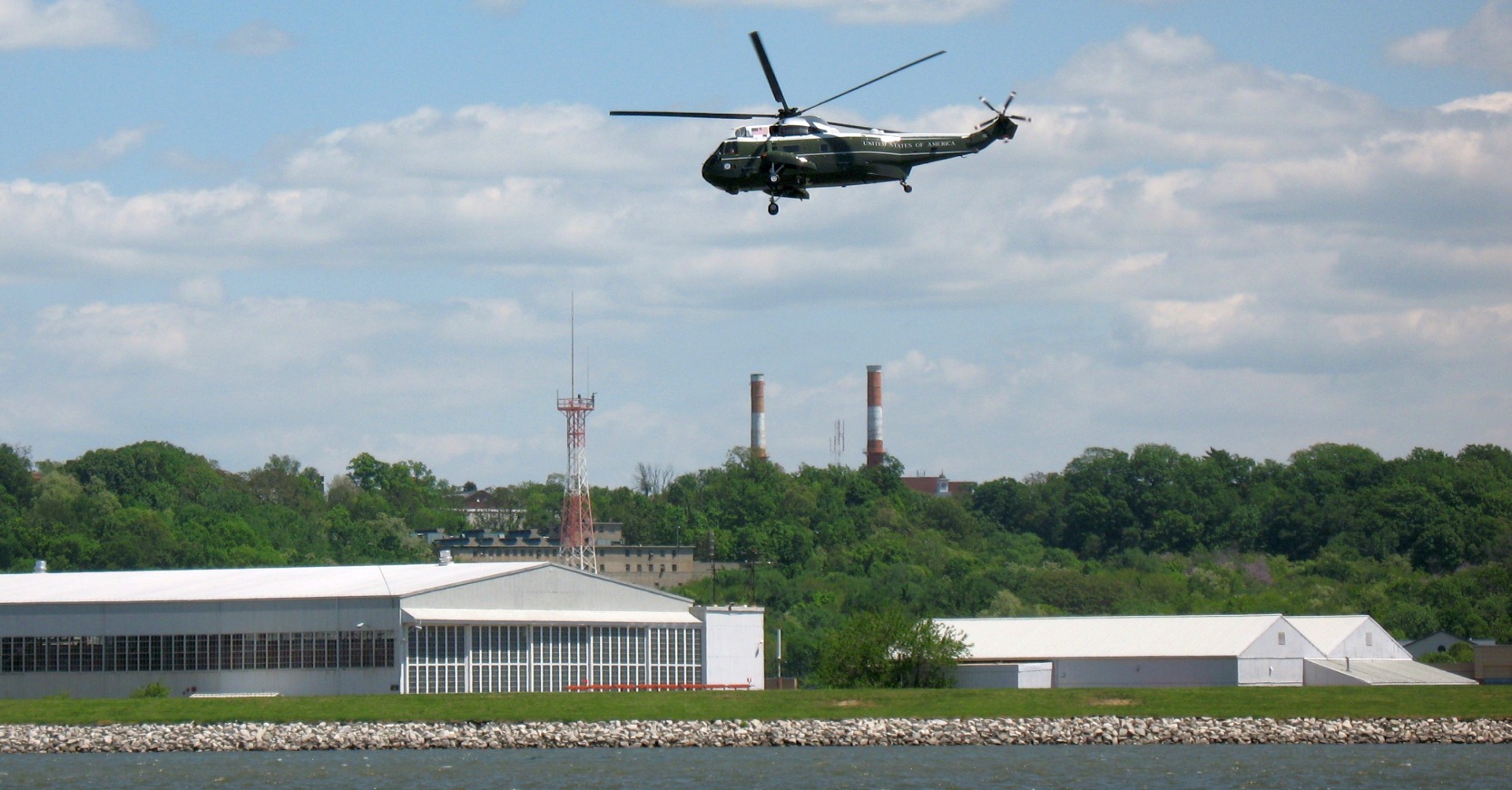
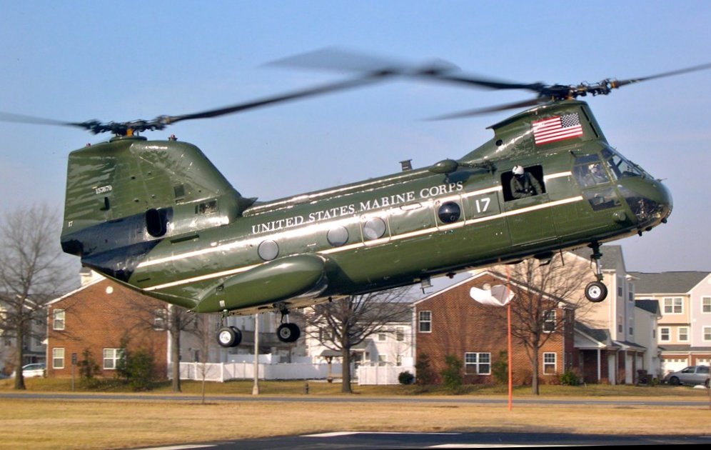
A 5/6/07 photo looking east at a Marine One Sikorsky VH-3 overflying the former Anacostia seaplane hangar.
A 1/5/10 photo by Leonard DeFrancisci looking northwest at what appears to be the only remaining fixed-wing aircraft at NAS Anacostia:
a North American T-28 Trojan, mounted on a pylon next to the main entrance to the base.
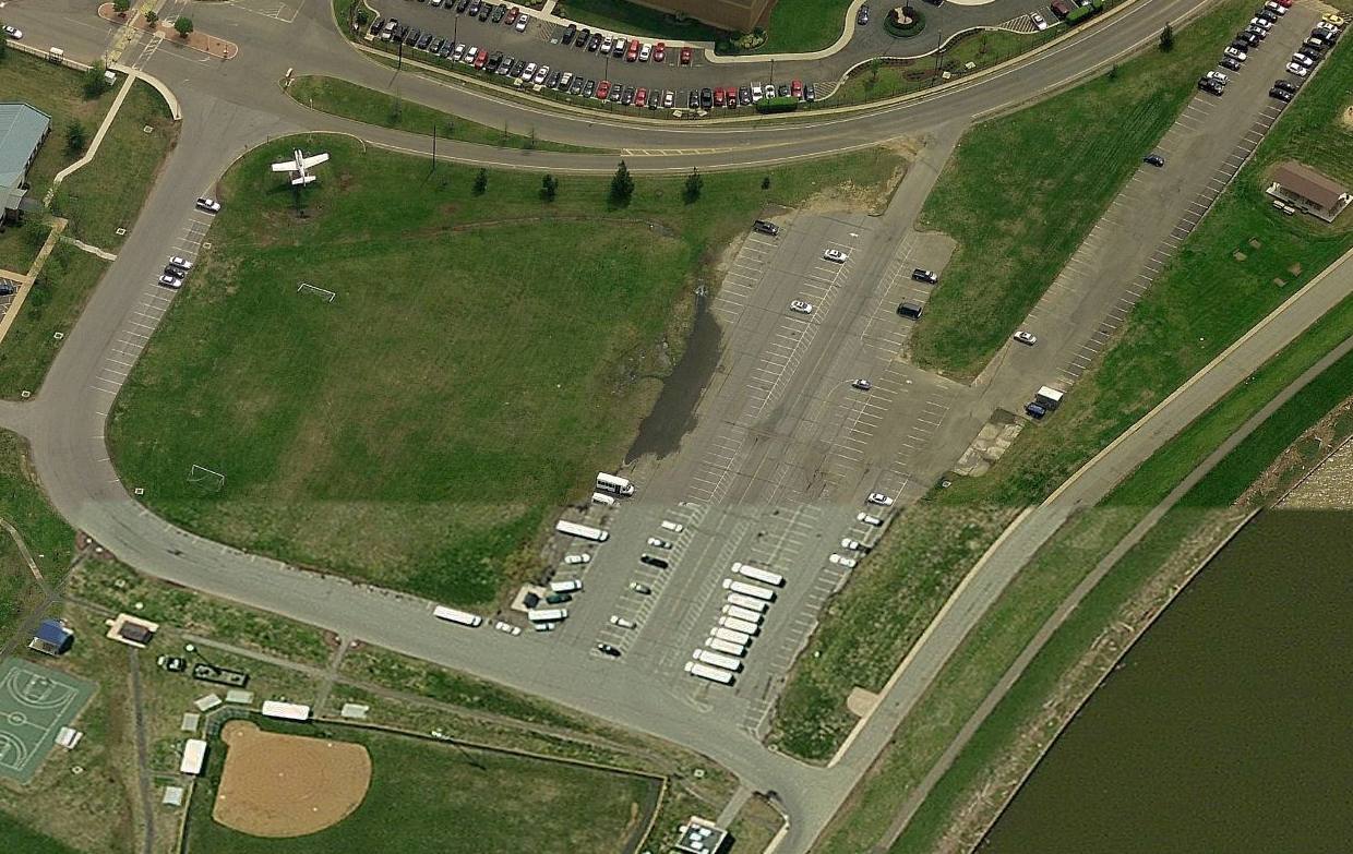
A circa 2010 aerial view looking south at the main entrance to the Anacostia base,
showing ironically what is the largest remaining piece of the NAS Anacostia's former main runway (its northern end), now used as a parking lot.
A 12/10/11 photo by Paul Freeman looking east at the Anacostia NAF hangars & control tower,
with a “Marine One” Sikorsky VH-3D visible at the right.
A 12/10/11 photo by Paul Freeman looking east at the former Anacostia hangars.
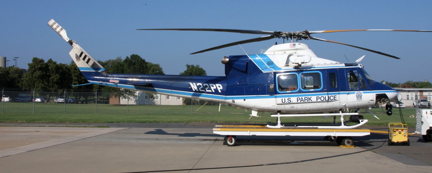
A 7/29/12 photo of US Park Police Bell 412EP, N22PP, C/n 36219, on a dolly at NAS Anacostia.
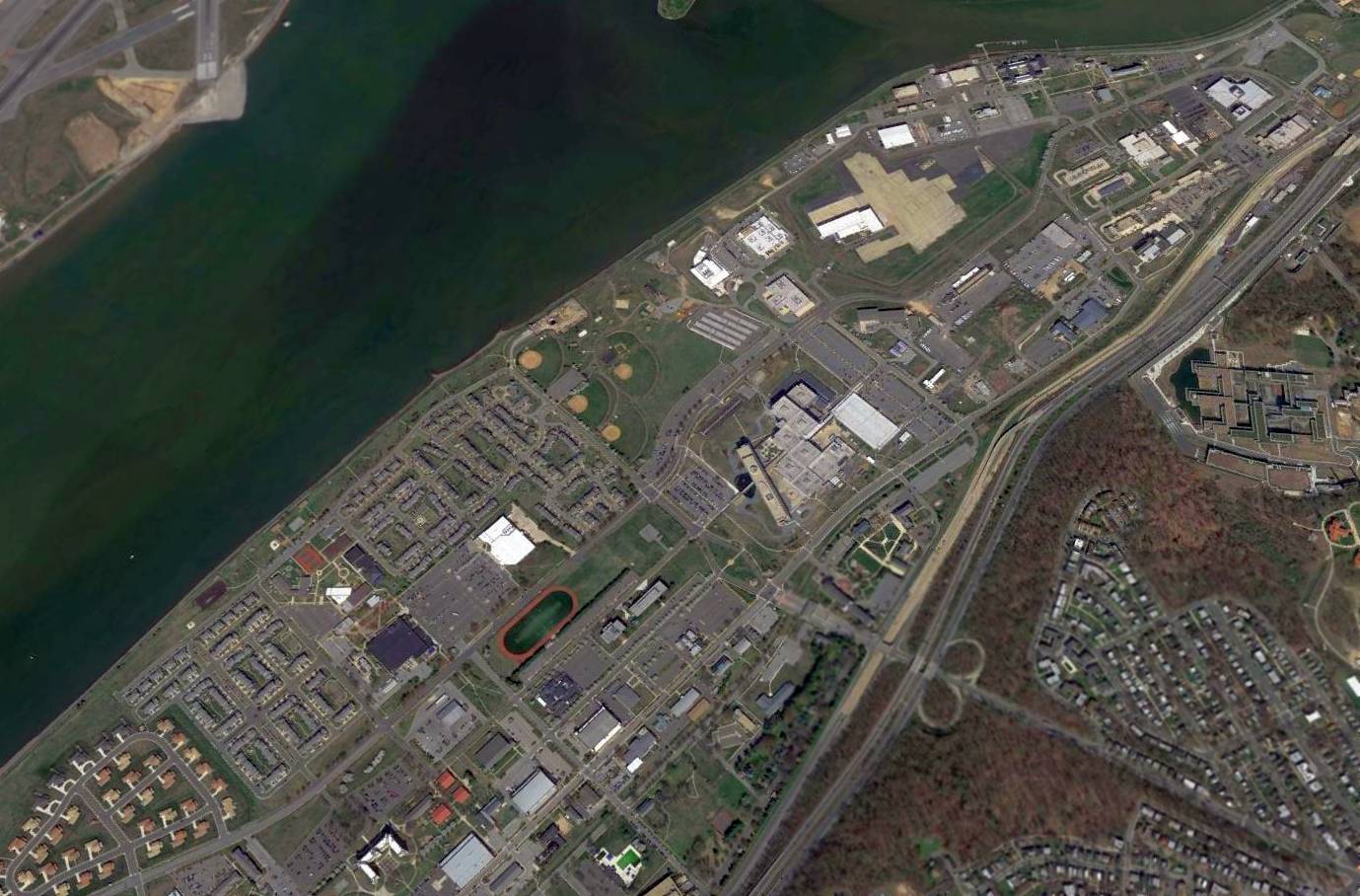
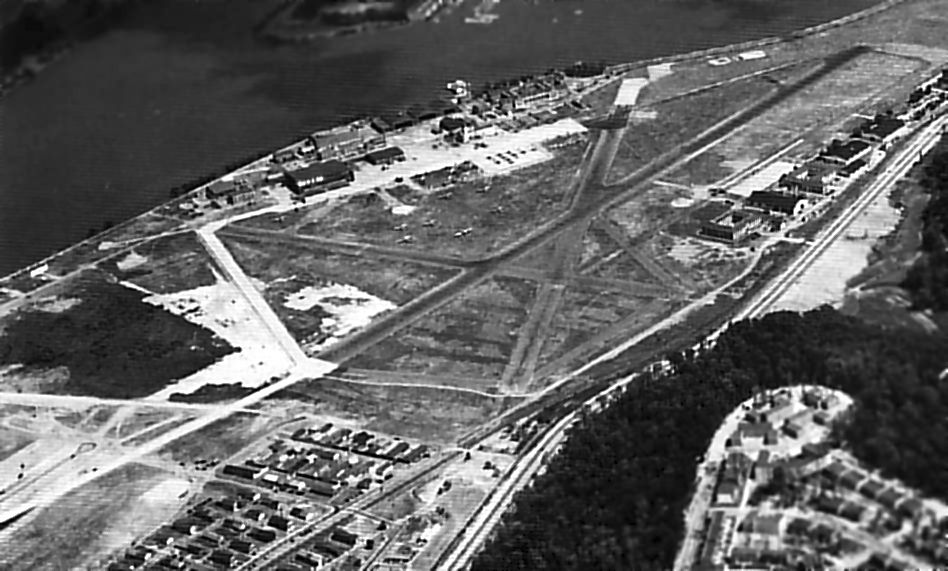
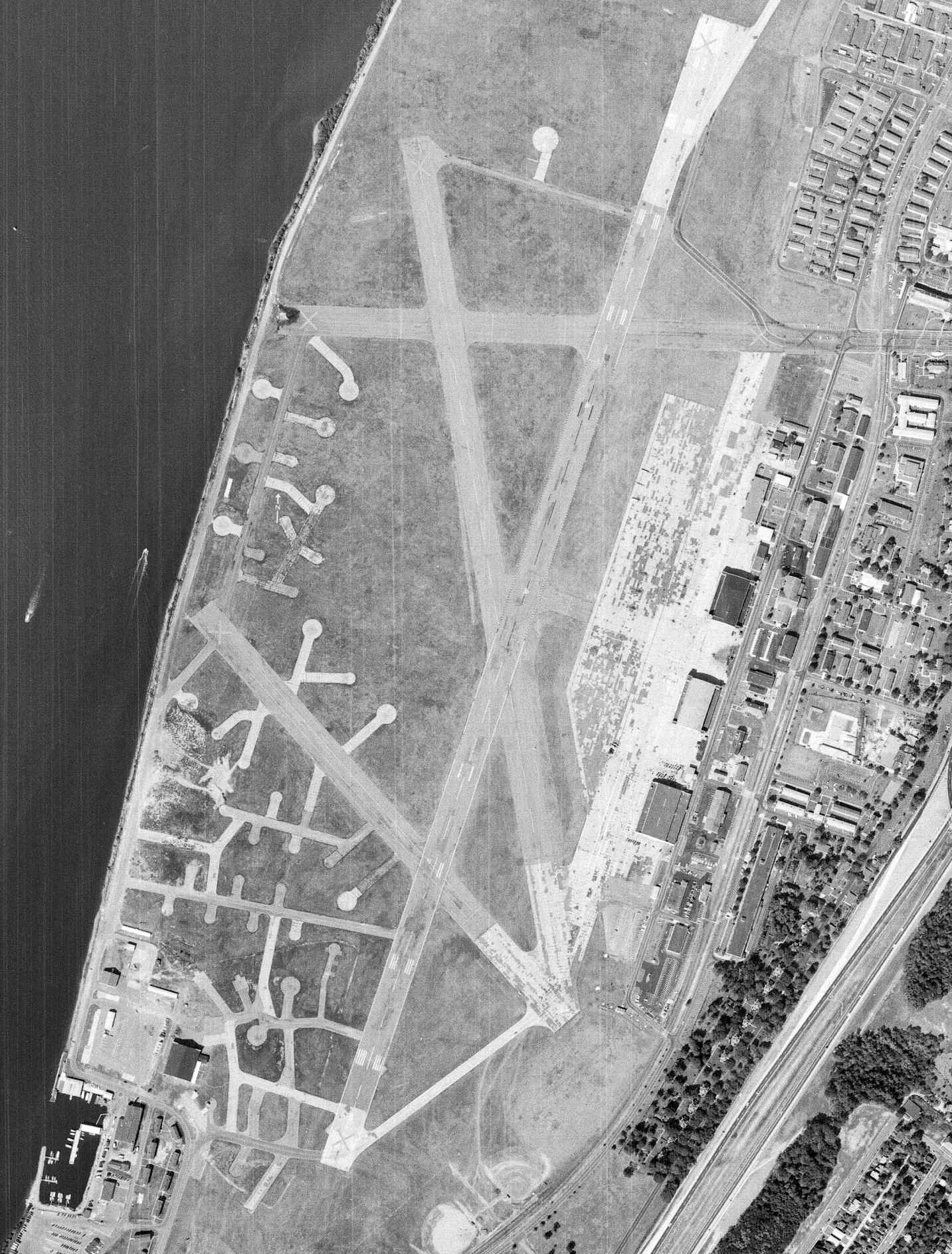
A 2015 aerial view looking northwest at the site of NAS Anacostia (at top), also showing Bolling AFB at the bottom.
As of 2016, although the helicopter facility at Anacostia remains in use, it is not depicted at all on aeronautical charts.
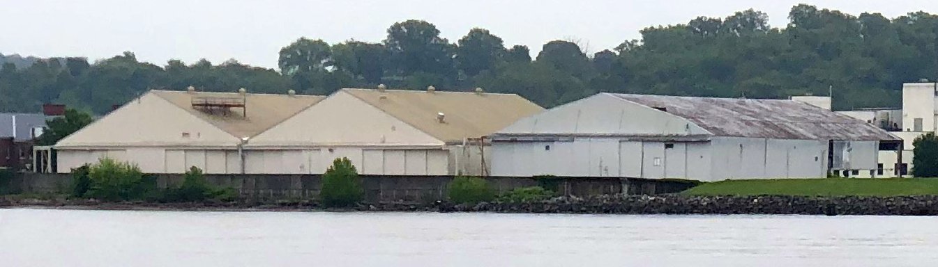
A 5/7/23 photo by Paul Freeman looking east at the former NAS Anacostia hangars.
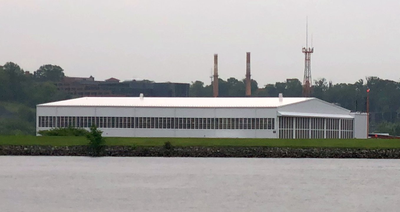
A 5/7/23 photo by Paul Freeman looking east at the former NAS Anacostia seaplane hangar.
____________________________________________________
Bolling Field / Bolling Air Force Base (BOF), Anacostia, DC
38.843, -77.016 (Southeast of Capitol Hill, DC)
The narrow plain along the eastern bank of the Anacostia River originally contained 2 military airfields:
the Navy's Anacostia Naval Air Station & the Army's Bolling Field.
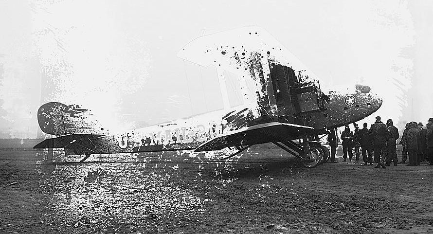
The earliest depiction which has been located of Bolling Field was an 11/19/19 Library of Congress photo.
The photo's original caption was, “The first twin-motor aeroplane to be placed on the aerial mail routes by the Post Office Dept. went into commission today.
The plane is Martin-equipped with two twin-6 Liberty motors. Photo made at Bolling Field.”
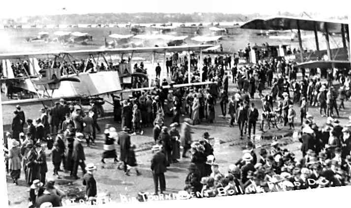
A Martin GMB biplane (on left) & another unidentified biplane at the first Army Air Tournament at Bolling Field in May 1920,
with several single-engine biplanes in the background.
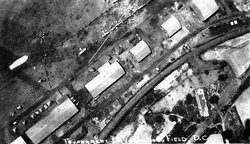
A circa 1920 aerial view of “Tournament Day, Bolling Field” (courtesy of Dan Friend)
depicted 9 aircraft parked along a row of hangars.
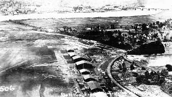
A circa 1920 aerial view looking north at Bolling Field (courtesy of Dan Friend) depicted a row of hangars.
An undated (circa 1920s?) view looking north along Bolling Field (courtesy of Edward Das)
showing large numbers of unidentified Army biplane fighters & bombers,
with the U.S. Capitol Building visible in the background.
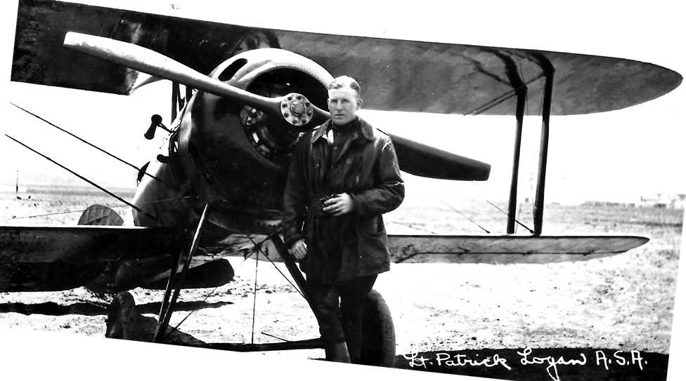
An undated photo of Lt. Patrick Logan in front of Nieuport 28 fighter (“known as the Red Devil”), presumably at Bolling Field (courtesy of Dan Friend).
According to Dan Friend, the photo is “almost certainly taken of him about 2 months prior to his death at the First Bolling Air Tournament in 1920.”
Baltimore's Logan Field was eventually named in honor of Lt. Logan.
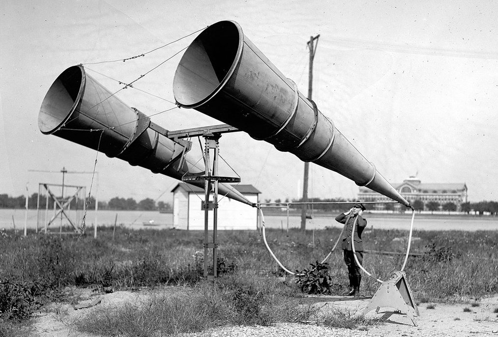
A 1921 photo looking east at amplifiers being tested/demonstrated at Bolling Field, with Ft. McNair's Army War College visible in the background on the opposite side of the Anacostia River.
The amplifiers were an early attempt at an air defense early-warning system.
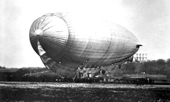
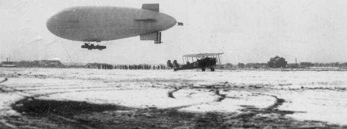
A 12/17/21 photo of the Army airship Roma (which had been purchased from Italy) at Bolling Field.
A mid-1920s photo looking west at Bolling Field, with a single plane in front of the hangar.
An undated (circa 1920s) photo (courtesy of Chris Roth) showing a C-Class blimp & 2 unidentified Army biplanes on a snowy field.
Chris reported the photo was “taken by my grandparents. It was labeled 'Arlington, Virginia' & was in an album of pictures from the mid 1920’s.”
However, according to Pete Penczer, “I believe that this photo was taken at Bolling Field rather than Hoover Field.”
According to Mike Schoen, “I can confirm that the photo was taken at Bolling.
The building [visible in the background] is Roosevelt Hall, home to the National War College.
The War College features prominently in many early photos of Bolling Field / Naval Air Station Anacostia.”
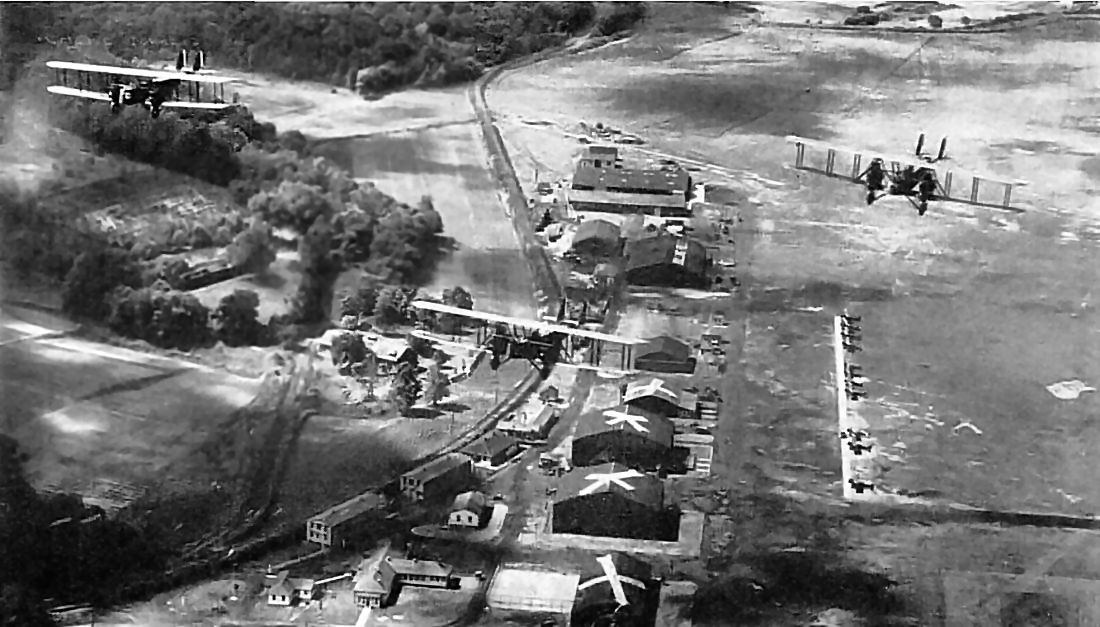
A 1924 aerial view of 3 Martin biplane bombers overflying the row of hangars at Bolling Field,
with a large number of smaller aircraft parked along the airfield.
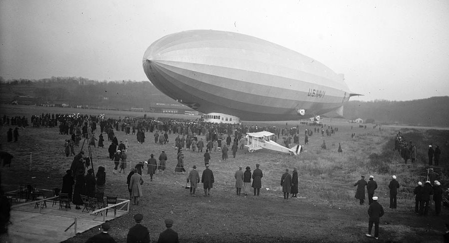
An 11/25/24 photo of the Christening of the Navy airship Los Angeles at Bolling Field.
The 1926 USGS topo map (courtesy of Laurence Burke) depicted “Bolling Field”
as having a row of small buildings along the northeast side of the field,
with the “Naval Air Station” located to the southwest.
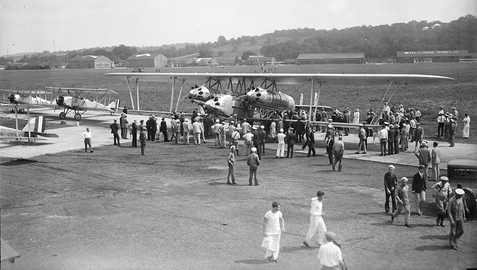
A 1926 photo of a public display of the triple-engine Sikorsky S-35 biplane at Bolling Field.
John Bybee reported, “The S-35 left Roosevelt Field for Bolling on 9/9/26 & returned 9/10/26, prior to its fatal transatlantic attempt on 9/21/26.”
For several years the Army & Navy shared the use of the grass landing area in between their two facilities.
The 1927 Department of Commerce Airway Bulletin (courtesy of David Brooks)
depicted an unusual layout of “Bolling Field” occupying the majority of the site,
with the “U.S. Naval Air Station” occupying a small cutout along the river on the west side.
A 1927 USAAC photo of an Atlantic-Fokker C-2 (S/N 26-203) at Bolling Field.
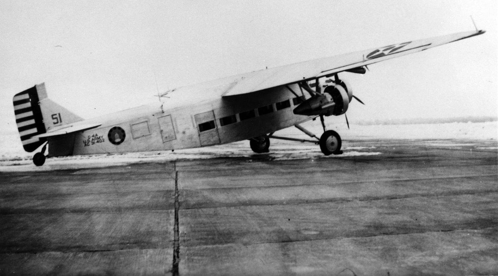
A circa 1927 USAAC photo of a Ford C-4A Tri-Motor #51 (S/N 31-402) based at Bolling Field.
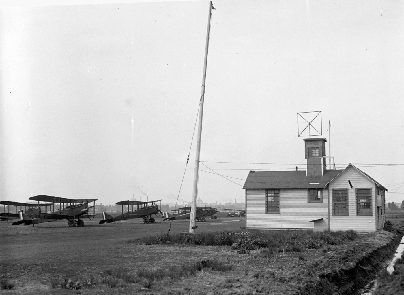
A circa 1928-30 photo of DH-4 Jenny biplanes at Bolling Field.
The dome of the U.S. Capitol building can just be seen over the plane in the middle.
The February 1929 V-234 Baltimore-Washington-Norfolk Navy Aviation Chart depicted Bolling Field
as an irregularly-shaped grass field with a row of buildings on the west & east sides.
The earliest aeronautical chart depiction which has been located of Bolling Field was on the February 1929 V-234 Baltimore-Washington-Norfolk Navy Aviation Chart.
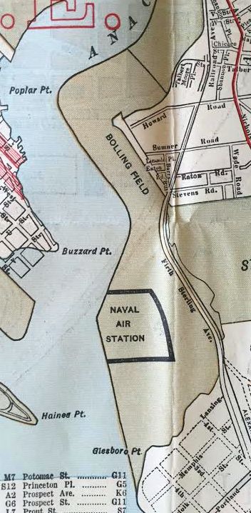
A 1929 street map (courtesy of Kevin Walsh) depicted “Bolling Field” along with Anacostia “Naval Air Station” to the south.
A 4/23/32 aerial view looking northeast at Bolling Field, with NAS Anacostia in the background.
A 6/2/31 photo looking north at the sole Lockheed Altair 8D Y1C-23 at Bolling Field – note the U.S. Capitol dome visible in the left background.
The Altair was not a huge success, with only a small handful of aircraft being produced or modified from Sirius airframes for a total of 11.
Of that total, the U.S. military ended up with 3 of the airframes: 2 for the Army Air Corps (the Y1C-23 & Y1C-25) & 1 for US Navy (the XRO-1).
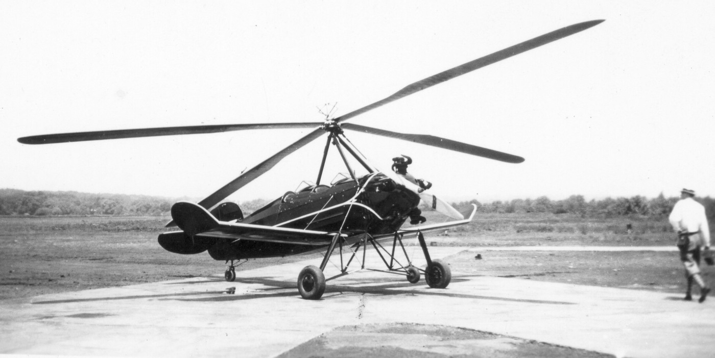
A 1933 photo by Jacob Boggs (courtesy of Paul Mallasch) of a Pitcairn autogiro at Bolling Field.
Paul Mallasch reported, “I know my Great Grandfather took these as my Grandfather identified these photographs as ones taken during a family vacation to Washington, D.C. in 1933.”
In 1935 the Army was forced to give up its shared use of Anacostia NAS,
and it built a new Bolling Field 2 miles south along the river bank.
Four new runways were built along with ground facilities.
The Airport Directory Company's 1937 Airports Directory (courtesy of Bob Rambo)
described Bolling Field as having 4 sod runways.
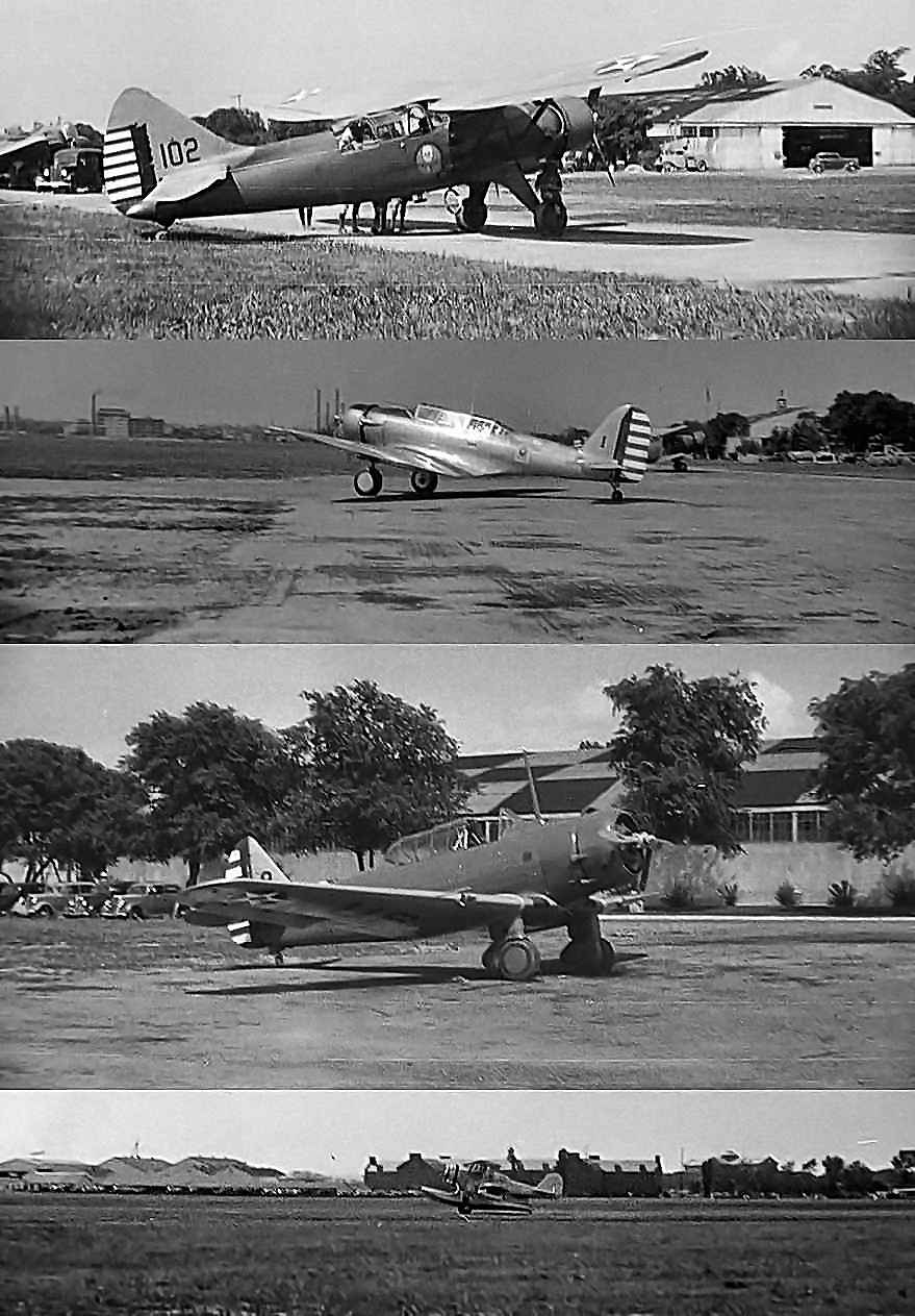
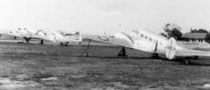
A series of remarkable circa 1937-41 photos which appear to be taken at either Bolling Field or Anacostia (courtesy of Lynn Towns).
Lynn reported, “I bought an antique 35mm Argus model A camera that, according to the serial number, is a 1937 model.
It included 2 rolls of developed film in metal cans. Since I am a pilot, I was surprised to find these negatives included pictures of airplanes.
The pictures on one film are a documentation of a young boy's trip with a Cleveland Boy Scout troop to Washington DC.
There are pictures of some military airplanes in Army Air Corps colors
that I believe were probably taken at Bolling Field and Anacostia Naval Air Station.”
The pictures depicted (from top), a Douglas O-46A, a Northrop A-17 Nomad,
a North American BT-9 Yale, and a Grumman J2F Duck amphibian.
A 1939 aerial view looking northeast at the "New" Bolling Field.
The field had evidently gained paved runways at some point between 1937-39.
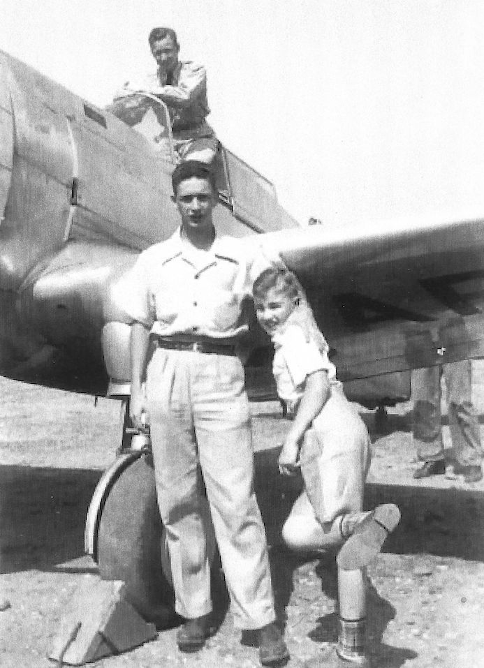
A 6/20/39 photo of John Loveless & others in front of a Curtiss P-36 Hawk at Bolling Field (courtesy of Kate Michler).
Kate Michler reported, “My grandfather [John Lovelss] had just graduated from the Army Air Corps at Randolph Field, San Antonio, and he flew to Bolling Field to visit his parents & two younger brothers who lived in D.C.”
An August 1939 photo (courtesy of Gene Burns) of the PA National Guard's 103rd Observation Squadron at Bolling Field,
in front of several Douglas O-46s (high-wing) & North American O-47s (low-wing) observation/liaison aircraft.
Gene's grandfather John Joerg is among those pictured.
An undated aerial view ofrom a November 1939 depiction of Washington Restricted Areas (from the Philadelphia National Archives, courtesy of Ron Plante)
depicted Bolling Field as having 4 runways.
A circa 1939-40 photo by Thomas McAvoy of a Martin Maryland twin-engine bomber in front of the Bolling Field hangars.
John Voss observed, “The aircraft is painted in French camouflage (without insignia) and therefore destined for France.
Being that the US had not entered the war no insignia was applied so as to provide a ‘degree of security’
as to its intended customer…not an uncommon practice in those early days.
A January 1940 photo by Thomas McAvoy of the sole prototype of the Boeing XB-15 bomber at Bolling Field.
When created the XB-15 was the heaviest aircraft yet built in the US.
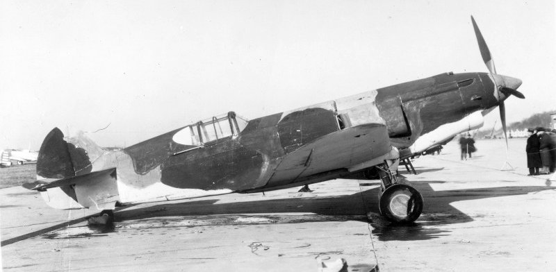
A January 1940 photo of the sole Curtiss XP-37 (37-375) fighter at Bolling Field.
Bolling served as the headquarters of the Continental Air Forces during WW2,
and training was conducted of existing combat air units.
It served as the primary military air facility for the capital region,
including serving as the home of the official aircraft of Presidents Roosevelt & Truman,
a Douglas C-53C nicknamed the "Sacred Cow".
A 10/23/43 aerial view looking southwest at Bolling Field from the 1945 AAF Airfield Directory (courtesy of Scott Murdock)
depicted the field as having 4 paved runways.
A 7/10/44 US Navy aerial view looking north at Bolling Field (bottom-center) & NAS Anacostia (upper-right). Note the taxiway connecting the 2 airfields.
A WW2-era aerial view looking northwest at Anacostia NAS, with the runways of Bolling AFB just visible to the left (National Archives photo).
The 1945 AAF Airfield Directory (courtesy of Scott Murdock)
described Bolling Field as a 630 acre irregularly-shaped property within which were 4 bituminous concrete runways,
the longest being the 5,000' north/south strip.
The field was said to have 3 brick & concrete hangars, with the largest measuring 260' x 203'.
All of Anacostia NAS & Bolling AAF were depicted as an empty “Military Reservation” on 1940s maps,
without depicting any runways or any other details, presumably due to wartime security concerns.
An August 1945 photo (courtesy of Ed Di Lalla) of a Beech C-45 Expeditor of Flight A being maintained at Bolling Field.
Ed Di Lalla recalled, “My dad Frank Di Lalla is working on the left engine. He was 22 years old in 1945, a member of the 16th Photographic unit stationed at Bolling Field during WWII.”
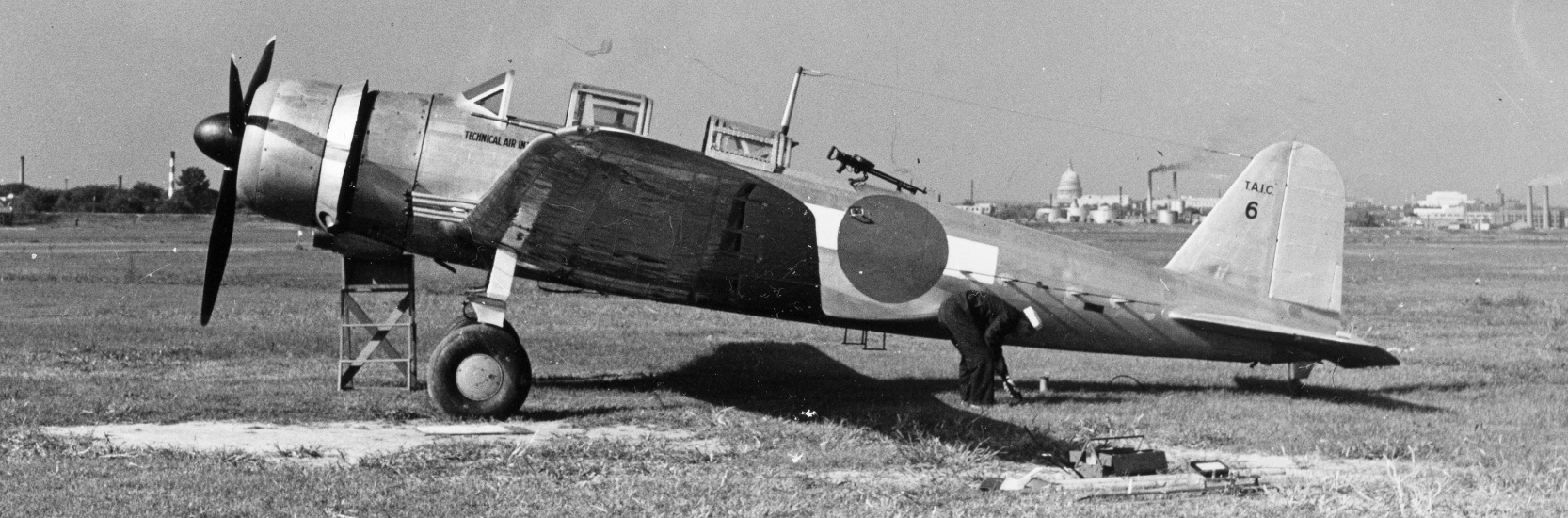
A circa 1945 photo of a captured Japanese Nakajima B5N Kate carrier-based torpedo bomber at Bolling Field, in the markings of the Technical Air Intelligence Center.
Note US Capitol dome in the background.
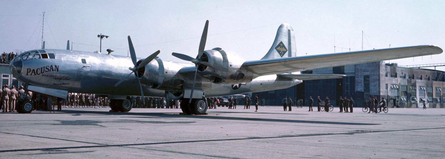
A 1946 photo of Pacusan Dreamboat, Boeing B-29B Superfortress, 44-84061, at Bolling Field.
The Pacusan Dreamboat several record-breaking flights, including an October 1946 non-stop flight from Hawaii-Cairo over the North Pole.
This photo may show the crew being honored in Washington on their return from Cairo.
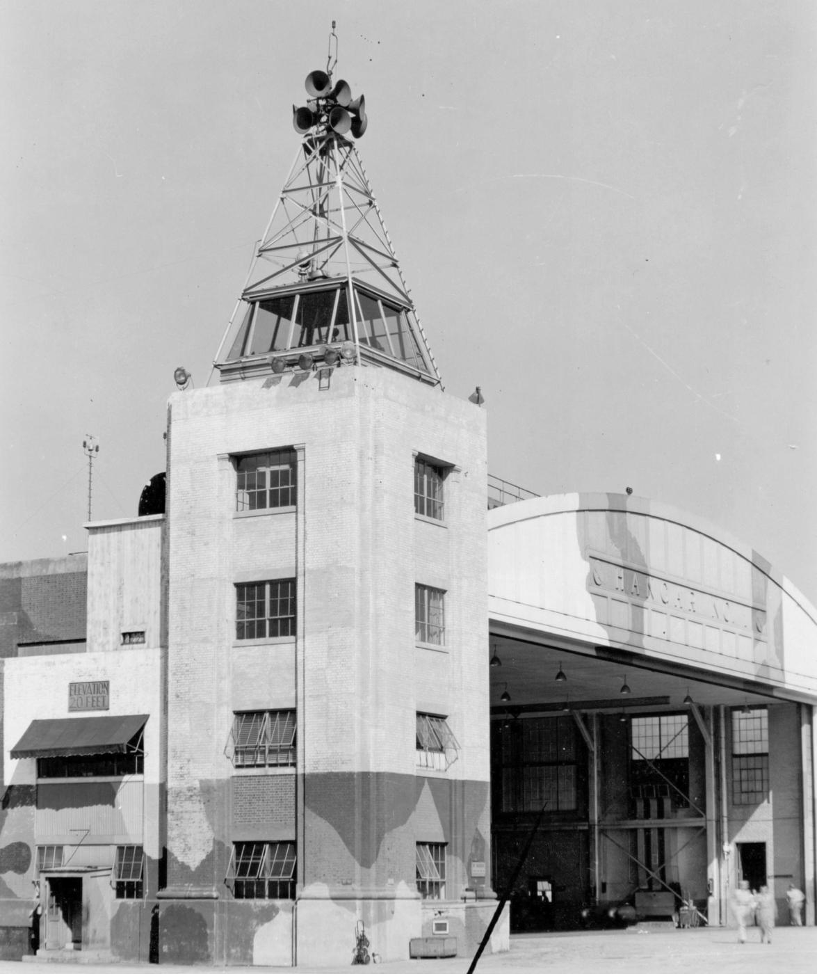
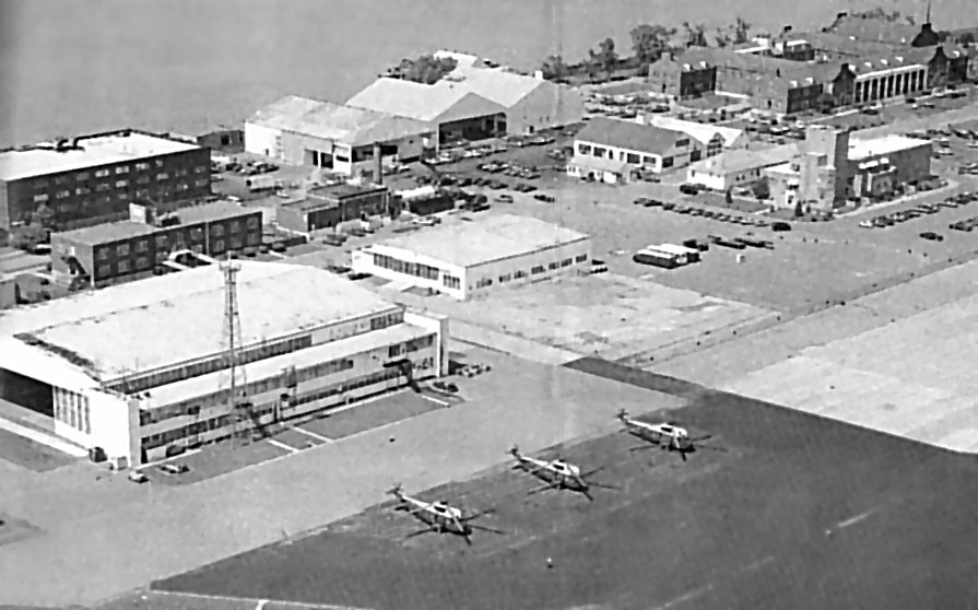
A circa 1946-49 photo (courtesy of Bruce Reid) of Bolling Field's Hangar #1 & its attached control tower.
Note the WW2-era camouflage paint remaining on portions of the building.
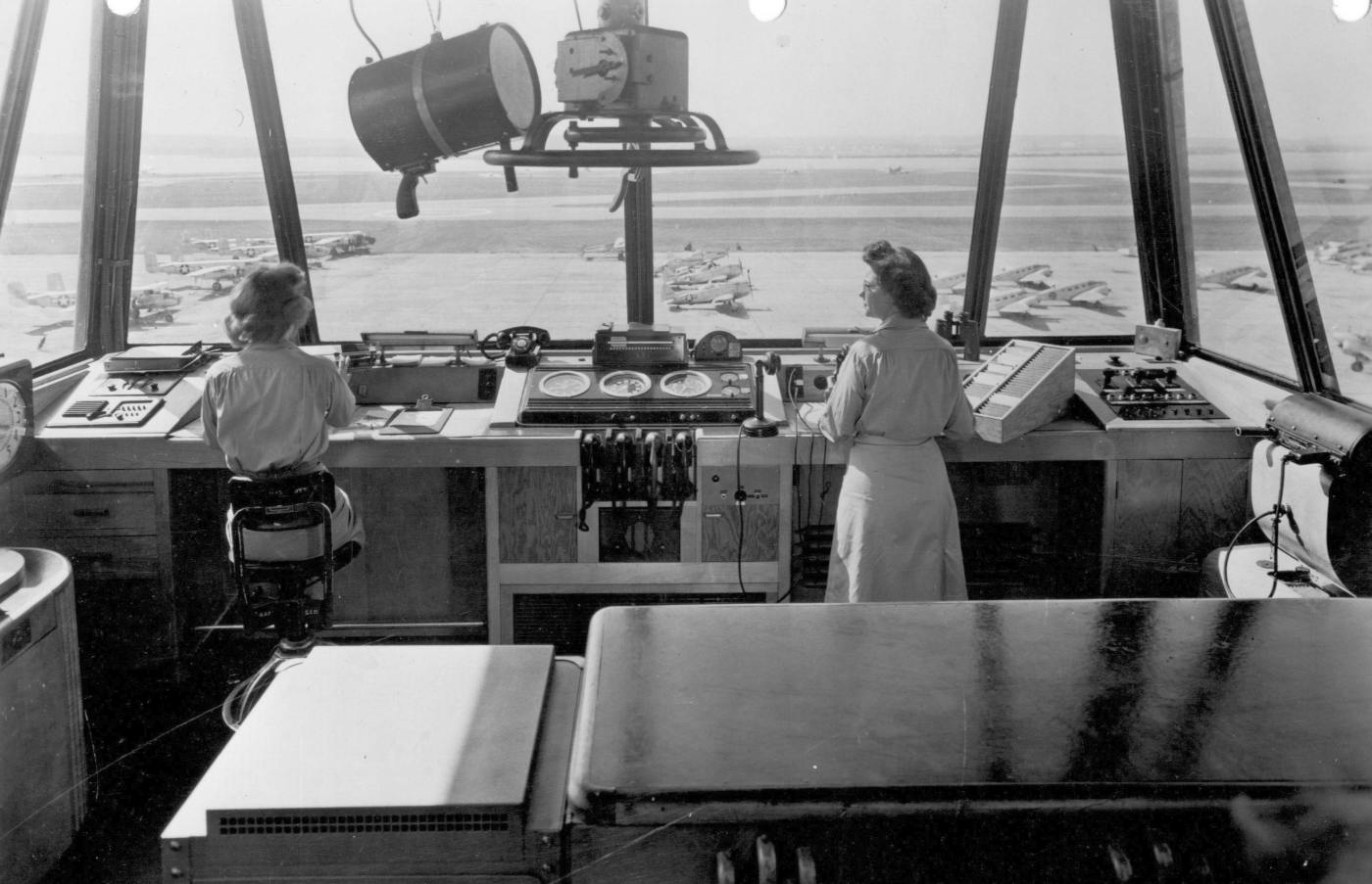
A circa 1946-49 photo (courtesy of Bruce Reid) of the interior of Bolling Field's control tower, with B-25 Mitchells, P-47 Thunderbolts, and other aircraft on a crowded ramp.
The April 1947 Washington Sectional Chart depicted “Bolling (Army)” having a 6,000' paved runway.
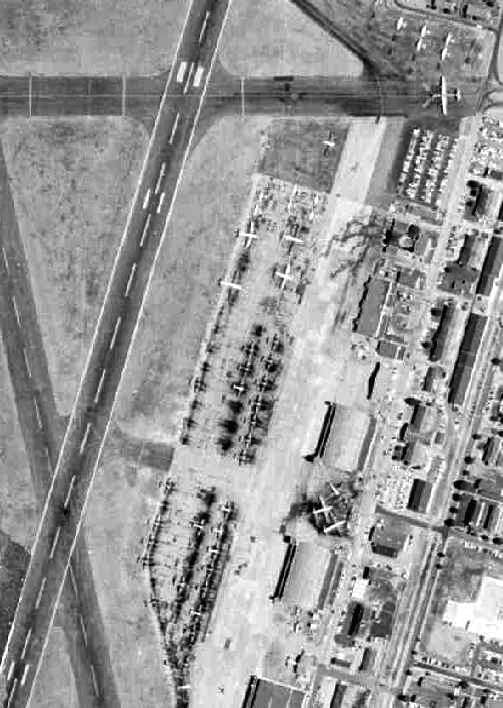
A 3/4/49 USGS aerial view of Bolling AFB, showing an amazing number of aircraft parked on the field,
including large numbers of single-engine & multi-engine aircraft on the ramp on the east side,
as well as large numbers of C-47s parked in individual dispersal pads along the river on the southwest side of the runways.
Anacostia NAS & Bolling AFB, as depicted on the 1949 USAF Target Complex Chart.
Anacostia NAS & Bolling AFB, as depicted on a 1952 street map (courtesy of Kevin Walsh).
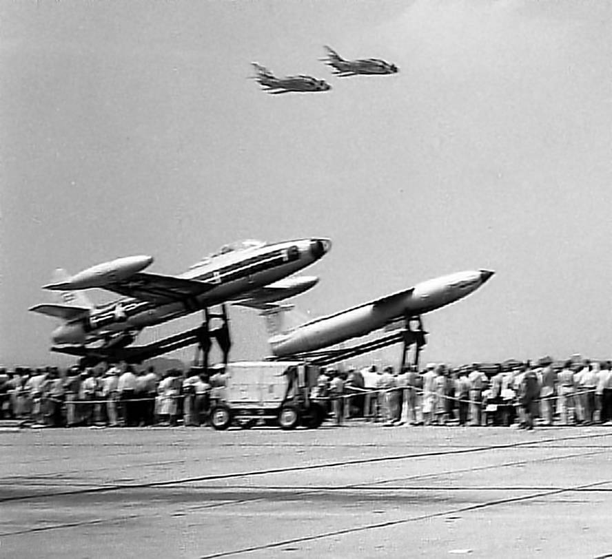
A circa 1954-56 photo by Howard Marler (courtesty of Helen Marler) of 2 Thunderbirds F-84F Thunderstreaks
overflying a rare EF-84G Thunderjet & a MGM-1 Matador at a Bolling AFB airshow.
The EF-84G was a zero-length launch version of the F-84 intended for point defense, using the booster rocket from the MGM-1 Matador.
It did not enter production.
A circa 1954-56 photo by Howard Marler (courtesy of Helen Marler) of a Thunderbirds F-84F Thunderstreak at a Bolling AFB airshow.
A 1954-59 photo by Paul LaPenta of a Douglas C-47 at Bolling AFB.
Paul LaPenta recalled, “The C-47 is one of about 5 to 10 we had. They were parked on the Potomac River side.
I was stationed at Bolling Air Force Base from 1954-59
when they had many B-25s, C-45s and C-47s used primarily for pilots to get their required monthly flying time in.
I was a radio repair airman & worked on many of these planes everyday for over 3 years. The radio shop was in Hangar 1. I worked out of all 3 hangars.
Hangars 1 & 2 were all worked in by Air Force personnel, while Hangar 3 was made up of mainly civilian personnel.”
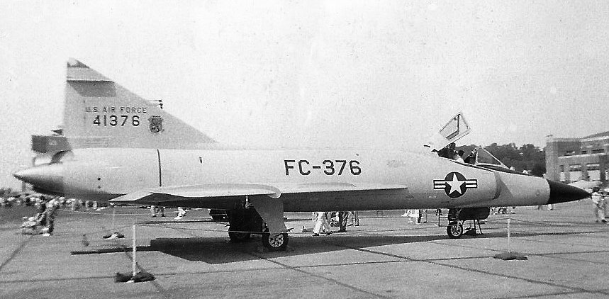
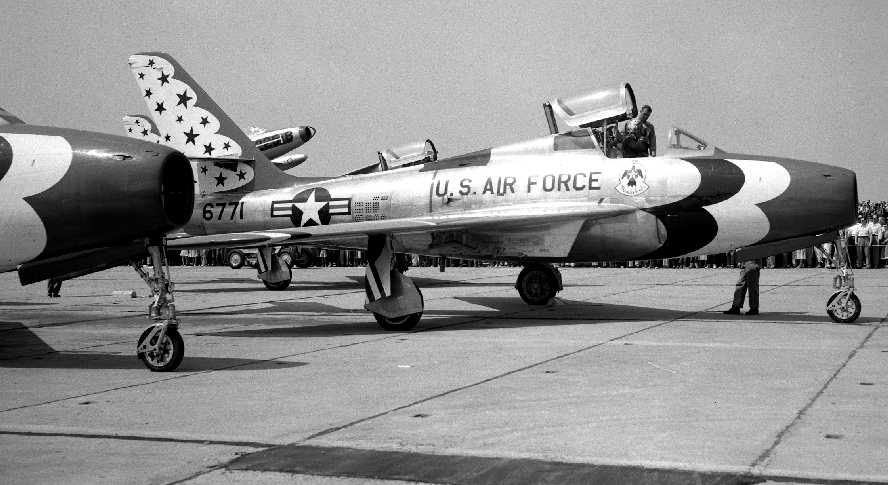
A 5/19/56 photo of a Convair F-102A Delta Dagger at the Bolling AFB Airshow.
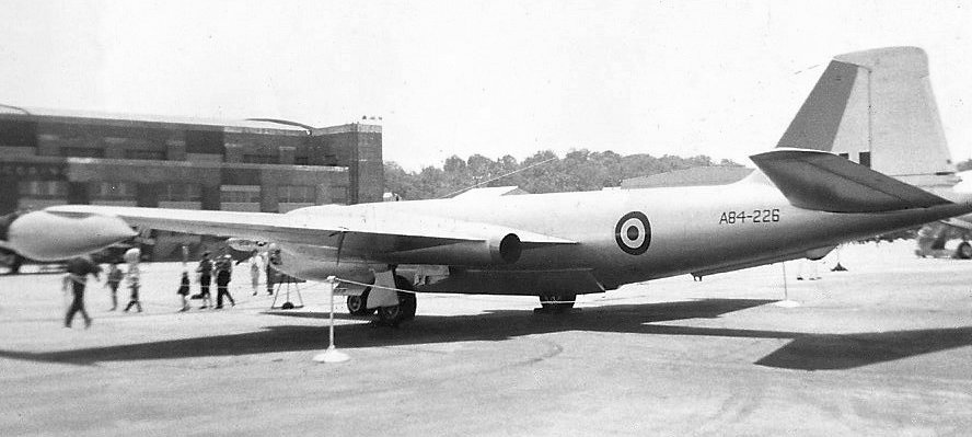
A 5/19/56 photo of English Electra Canberra bomber A84-226 at the Bolling AFB Airshow.
According to John Voss, “RAAF Canberra A84-226 was one of 5 RAAF Canberras that made a 'Goodwill Tour' of the USA.”
The July 1956 Washington Local Aeronautical Chart (courtesy of Tim Zukas)
depicted Bolling as having 4 paved runways, with the longest being 6,000'.
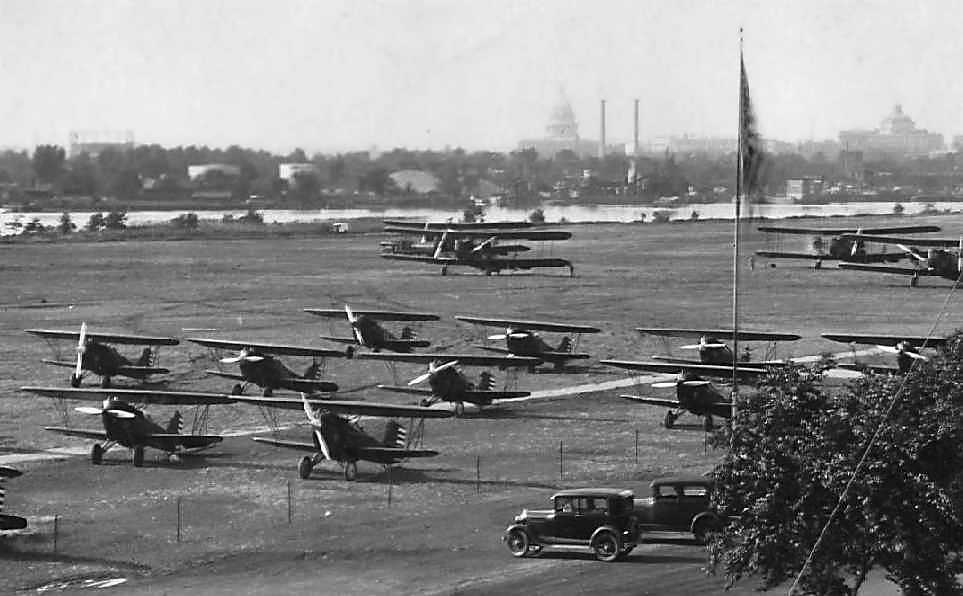
A 1957 aerial view of the large number of small & large aircraft parked on the ramp on the east side of Bolling AFB.
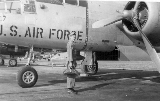
A July 1957 photo of Paul LaPenta & a North American B-25 Mitchell bomber at Bolling AFB.
Paul LaPenta recalled, “The B-25 is one of the 30 or more we had which were parked on the hangar side of the base.”
A September 1957 photo by Paul LaPenta of Beechcraft C-45 Expeditors at Bolling AFB.
Paul LaPenta recalled, “The C-45s were among the 10 or more that we had.
They were replaced sometime in late 1958 / early 1959 with about the same amount of Cessna L-27s [pictured below].
All of these planes in some numbers were flown every day.”
A 1958 Army Map Service map (courtesy of Kevin Walsh) depicted Bolling Field as having 4 paved runways.
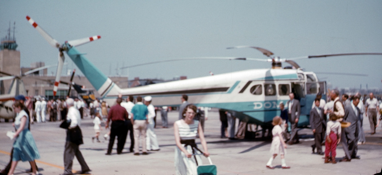
A 7/1/58 photo of an obscure Doman LZ-5 helicopter (one of only 3 built) at a Bolling-Anacostia airshow.
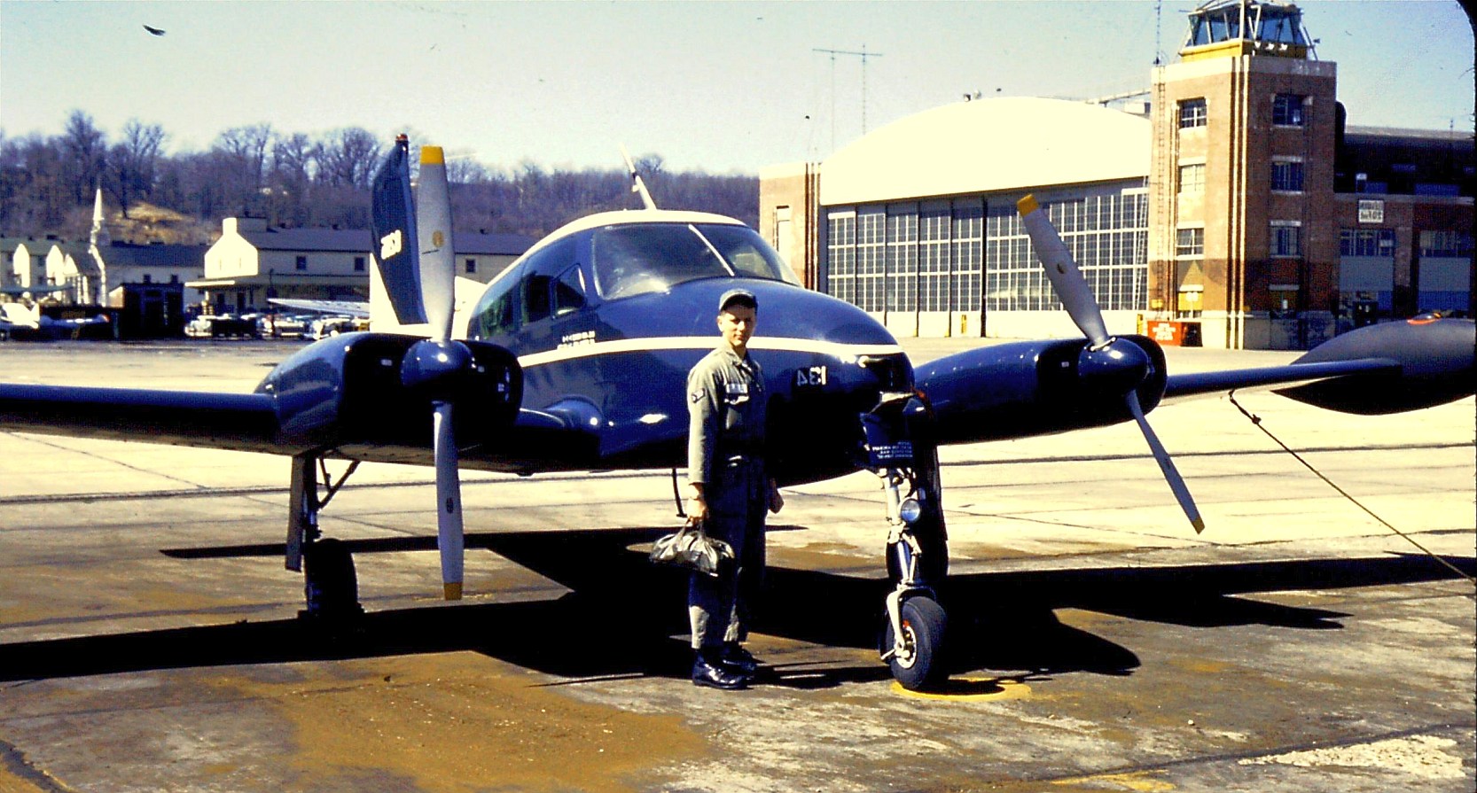
A 1958-59 photo of Paul LaPenta & a Cessna L-27 in front of the Bolling AFB control tower.
Paul LaPenta reported that Bolling's L-27s had replaced a similar number of Beechcraft C-45 Expeditors in late 1958 / early 1959.
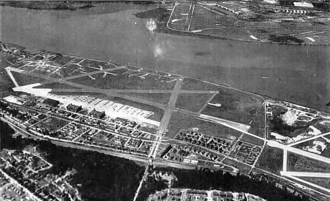
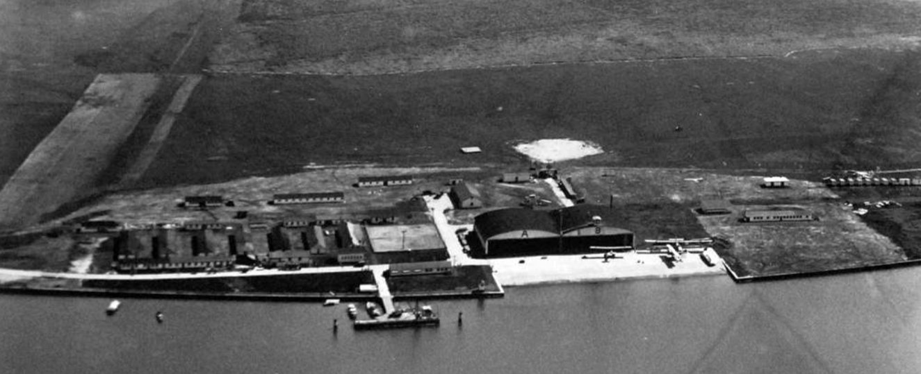
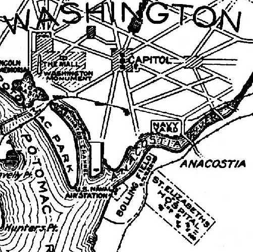
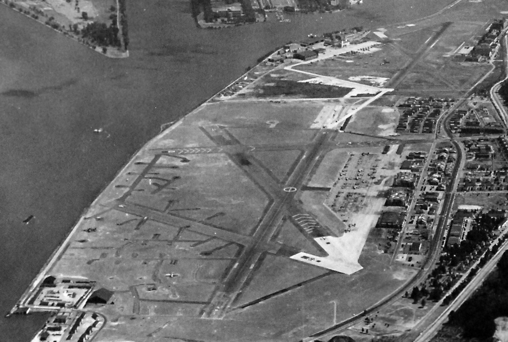
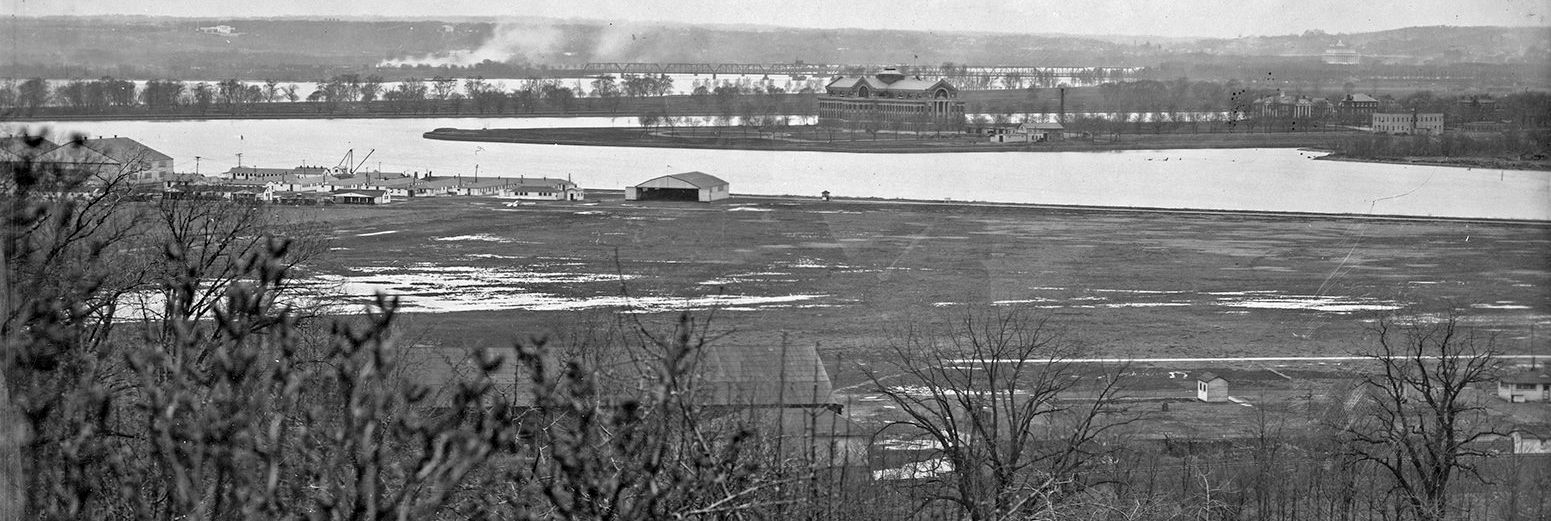
An undated aerial view looking southwest from an August 1959 article showing the amazing proximity of Washington's 3 large airfields:
Bolling Field (bottom-left), NAS Anacostia (bottom-right), and Washington National Airport (top-right).
The last aeronautical chart depiction which has been located showing Bolling AFB still open was on the July 1960 Washington Sectional Chart.
It depicted Bolling as having 4 paved runways, with the longest being 6,000'.
John Baker recalled, "Around 1960-61, my Dad was stationed at Anacostia Naval Air Station.
On Saturday mornings, my Mom & Dad would go to the commissary at Bolling Field for groceries.
I remember sitting in the car watching T-28s practice landings as they approached from the southeast,
landing on the runway that ran northwest towards the Potomac River.
The elevation of the terrain to the southeast was quite a bit higher,
so the planes really did fly 'down the hill' towards the runway, following the descending terrain.
The commissary was just northeast of the approach end of the runway, so I had a good view of the approach,
though I could not see the actual touchdowns as the planes disappeared behind the commissary building.
I also remember clearly seeing the C-47s parked on the tarmac directly across from the entrance road,
a little further towards the north end of the field."
The end of fixed-wing flying operations at both Anacostia NAS & Bolling AFB was brought about by 2 factors.
The first was the advent of the jet aircraft, which necessitated much longer runways
than could be accommodated in the constricted patch of ground along the Anacostia River
(the two bases are also bordered on the east side by the I-295 expressway,
which precluded any property expansion eastward).
The second factor making the closure unavoidable was the presence
of Washington National Airport directly across the Anacostia River,
only a mere mile away from the two military airfields.
National has evolved into one of the busiest airports in the world,
blanketing the area over Anacostia with extremely dense commercial air traffic.
A 1961 diagram of the Washington Airport Traffic Area displayed an “Anacostia/Bolling VFR Corridor”.
A 2/4/62 photo of Air Force 1100 Air Base Wing Convair T-29B Samaritan, 51-2802, C/n 230, at Bolling Field, with several C-54s visible in the background.
On 7/1/62, the last fixed-wing flight departed Bolling AFB, a C-54 carrying 33 passengers & 6 crew members, bound for nearby Andrews AFB.
The runways at Anacostia & Bolling were closed to fixed wing traffic in 1962,
and both Navy & Air Force fixed wing flying operations for the Washington DC area moved
to the much larger & less crowded Andrews AFB a few miles to the East.
The only aircraft visible on all of Bolling AFB in a 1963 aerial photo
was a group of 8 tandem-rotor helicopters (either CH-46s or CH-47s) parked on the ramp on the east side of the field.
The airfield & all of its facilities remained otherwise intact.
The last photo which has been located showing the runways of Bolling AFB remaining intact was a 9/26/64 USGS aerial view.
No aircraft were visible on the field.
The 1964 Washington Sectional Chart (courtesy of John Voss) still depicted the runways of NAS Anacostia & Bolling AFB, although both were labeled "Closed".
The runways of both NAS Anacostia & Bolling AFB were still depicted on the 1964 National Geographic Map of Suburban Washington (courtesy of David Brooks),
but both airfields were labeled "Runways Closed".
The runways of both NAS Anacostia & Bolling AFB were still depicted on the 1975 Washington Terminal Area Chart (courtesy of Ed Drury),
but both airfields were labeled "Closed".
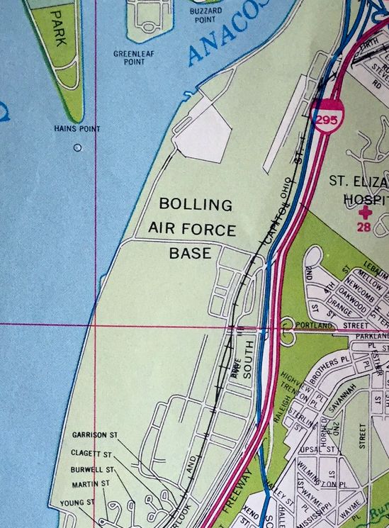
The Bolling runways had been covered by buildings at some point between 1964-79, as depicted by a 1979 aerial photo.
As of 2002, the only aviation facility which remained active at Bolling was a small heliport.
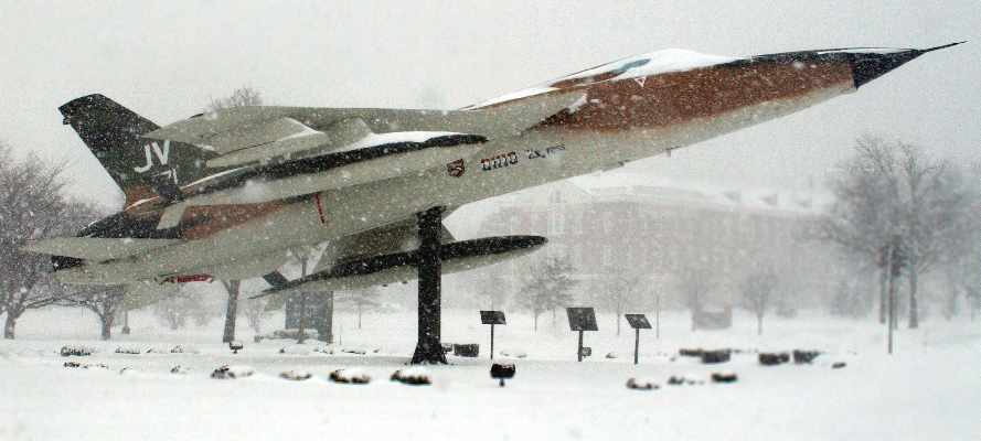
A February 2003 DOD photo of what appears to be the only remaining fixed-wing aircraft at Bolling AFB:
a Republic F-105 Thunderchief, mounted on a pylon in the center of the main entrance to the base.
Odd that an F-105 would be chosen for a display at Bolling, given that the aircraft had never operated from the field.
A 2/20/04 photo of 157679, a Vertol VH-46E of Marine Corps HMX-1 at Bolling AFB.
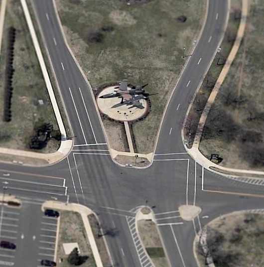
A circa 2005 aerial view looking west at a Republic F-105 Thunderchief,
mounted on a pylon in the center of the main entrance to the base.
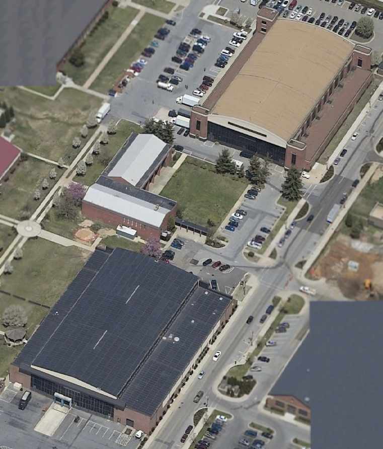
Although no trace of the runways at Bolling AFB are still visible,
a circa 2005 aerial view looking north shows 2 former hangars which remain in fine condition on the southeast side of the former airfield.
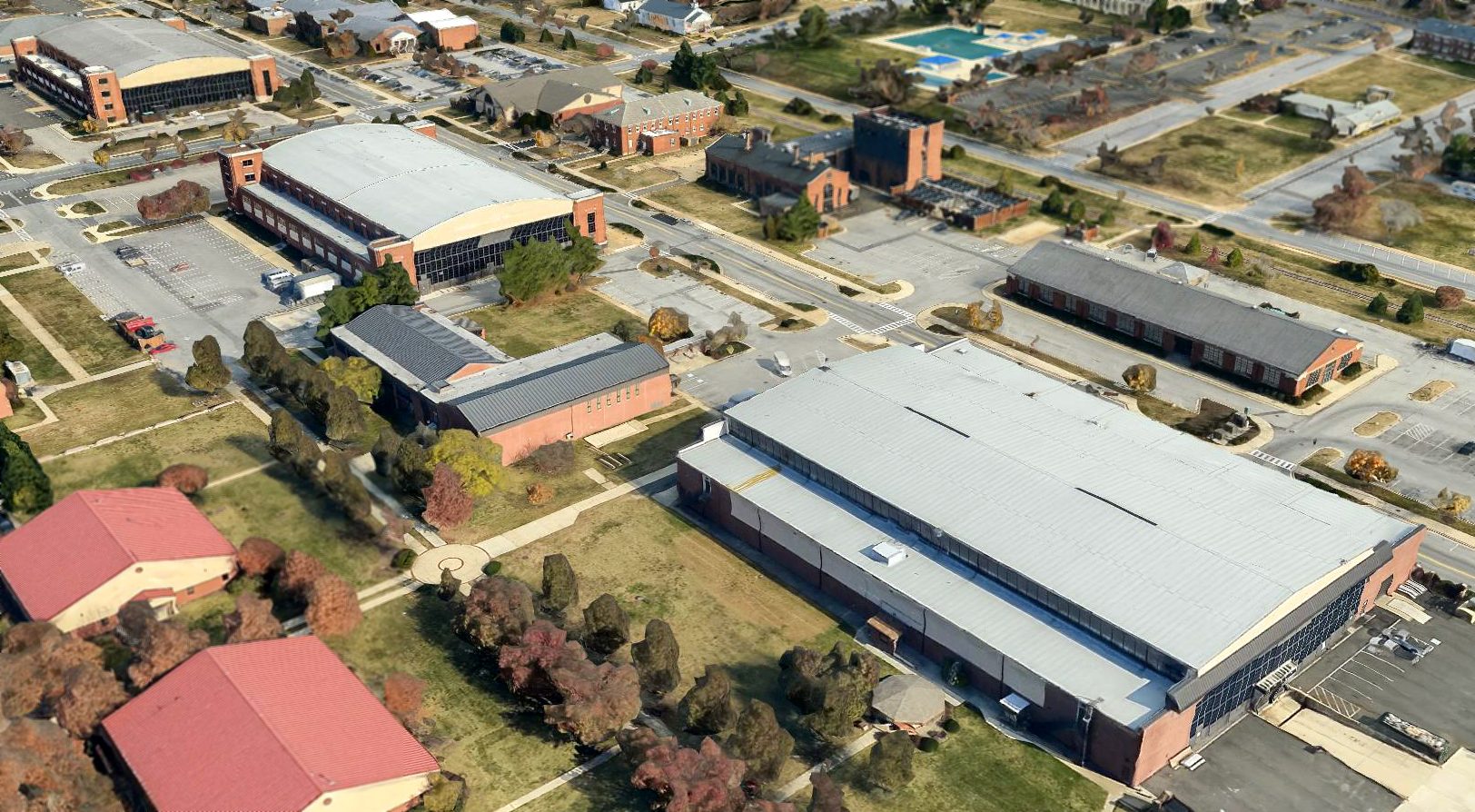
A circa 2010-2017 3-D aerial view looking northeast at 3 former hangars which remain at Bolling AFB.
A 2015 aerial view looking northwest at Bolling AFB (at bottom), also showing the site of NAS Anacostia at the top.
See also: http://www.bolling.af.mil/Organizations/11WGStaff/ho/index.htm.
____________________________________________________
____________________________________________________
Since this site was first put on the web in 1999, its popularity has grown tremendously.
If the total quantity of material on this site is to continue to grow,
it will require ever-increasing funding to pay its expenses.
Therefore, I request financial contributions from site visitors,
to help defray the increasing costs of the site
and ensure that it continues to be available & to grow.
What would you pay for a good aviation magazine, or a good aviation book?
Please consider a donation of an equivalent amount, at the least.
This site is not supported by commercial advertising –
it is purely supported by donations.
If you enjoy the site, and would like to make a financial contribution,
you
may use a credit card via
![]() :
:
![]()
Please consider checking the box to make a monthly donatation.
For a mailing address to send a check, please contact me at: paulandterryfreeman@gmail.com
If you enjoy this web site, please support it with a financial contribution.
____________________________________________________
This site covers airfields in all 50 states.