
Abandoned & Little-Known Airfields:
California: Santa Barbara area
© 2002, © 2025 by Paul Freeman. Revised 2/1/25.
This site covers airfields in all 50 states: Click here for the site's main menu.
For a 10th year, the CA pages of this website are sponsored by the California Pilots Association:
____________________________________________________
Please consider a financial contribution to support the continued growth & operation of this site.
Crawford Airport (revised 10/21/21) - Hancock Field (original location) (revised 2/1/25) - Lompoc Airport (original location) / Lompoc NAAF (revised 4/1/23)
Long Airfield / Machado Airfield (revised 4/1/23) - Parsons Airpark / Parsons Ranch Airpark (revised 2/1/25)
____________________________________________________
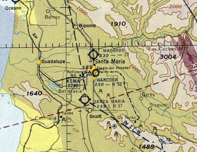
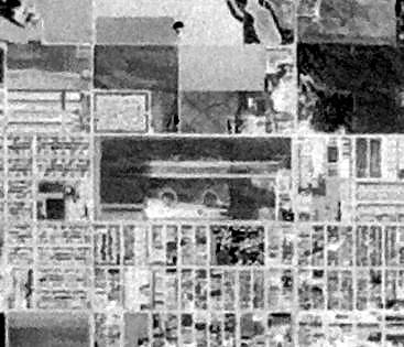
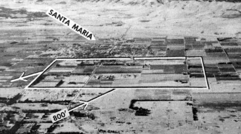
Long Airfield / Machado Airfield, Santa Maria, CA
34.983, -120.43 (Northwest of Los Angeles, CA)
Long Airfield, as depicted on the August 1943 San Francisco Sectional Chart.
Long Airfield was evidently established at some point between 1942-43,
as it was not yet depicted on the August 1942 San Francisco Sectional Chart.
The earliest photo which has been located of Long Airfield was on the August 1943 San Francisco Sectional Chart,
which depicted Long as an auxiliary airfield.
Long Airfield was evidently closed at some point between 1943-44,
as it was no longer depicted on the February 1944 through August 1946 San Francisco Sectional Charts.
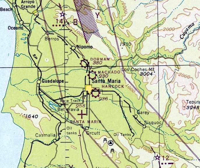
At some point between 1946-47, Long Airfield was evidently reopened under the name of Machado Airfield,
as that is how it was depicted on the February 1947 San Francisco Sectional Chart.
It depicted Machado as a commercial/municipal airport.
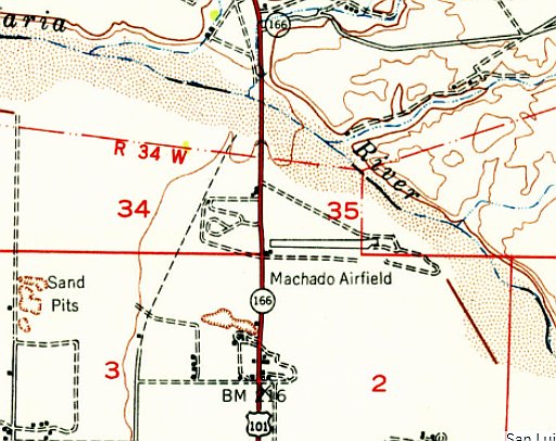
The earliest topo map depiction which has been located of Machado Airfield was on the 1947 USGS topo map.
It depicted Machado as having an east/west paved runway, with a small building on the southwest side.
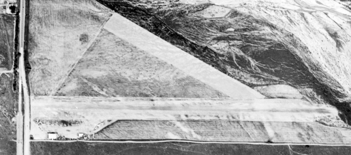
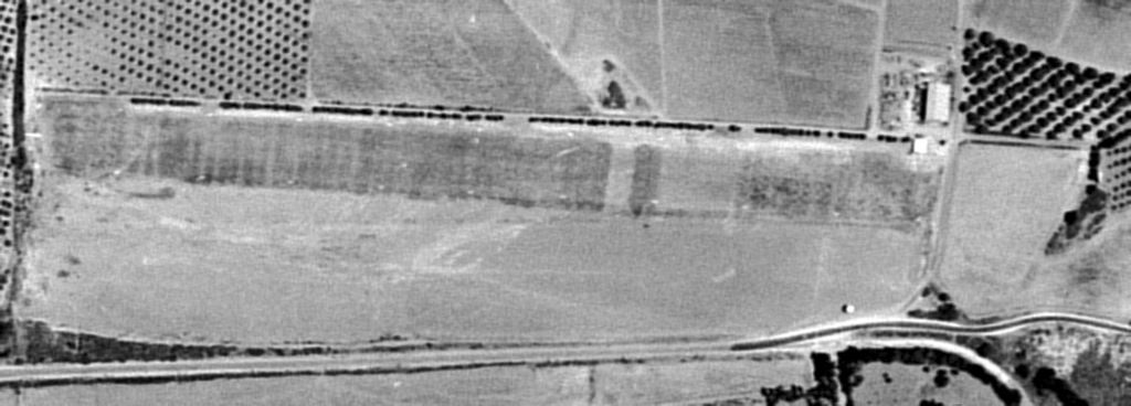
The earliest photo which has been located of Machado Airfield was a 3/27/49 aerial view.
It depicted Machado as having 2 unpaved runways, with 8 light single-engine planes parked near some small buildings on the southwest side.
The last aeronautical chart depiction which has been located of Machado Airfield was on the September 1957 San Francisco Sectional Charts (courtesy of Dale Knutsen).
It depicted Machado as having a 2,700' unpaved runway.
The last photo which has been located of Machado Airfield was a 1957 aerial view.
It depicted Machado as having an east/west runway, with 4 light single-engine planes parked near some small buildings on the southwest side.
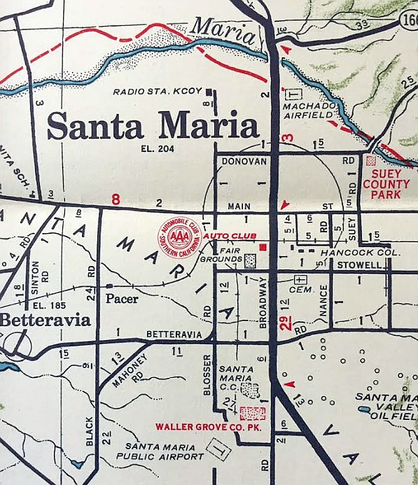
The last depiction which has been located of Machado Airfield was on a 1960 road map (courtesy of Kevin Walsh).
Dallam Oliver-Lee reported, “Machado Airfield... was abandoned in 1961, and destroyed in 1961-1964 when new US 101 & levee were built.”
A 1962 road map (courtesy of Kevin Walsh) no longer depicted Machado Airfield.
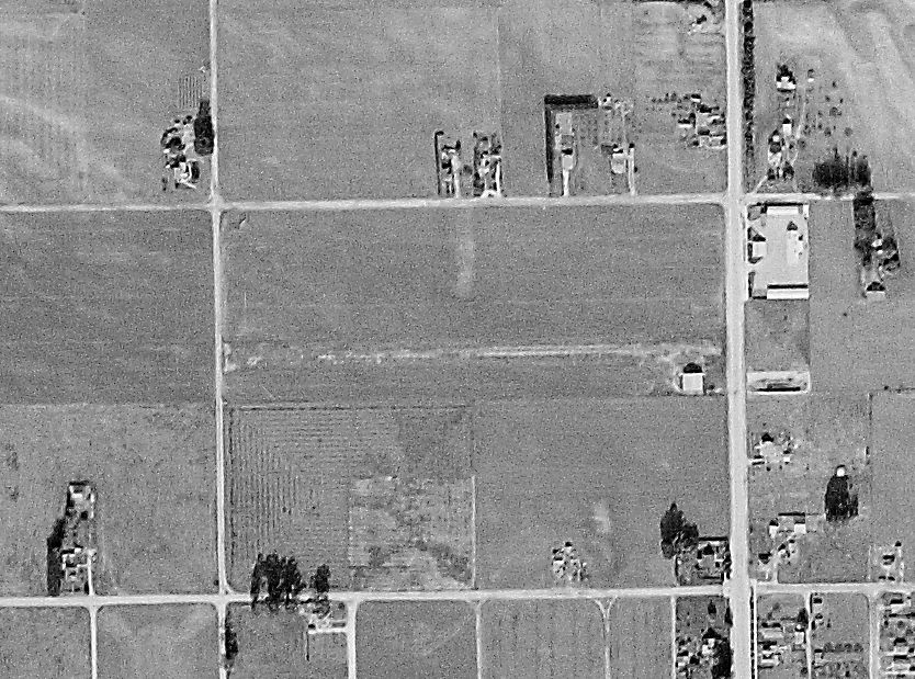
A 1967 aerial view showed Machado Airfield had been covered by the new 101 Freeway, with all traces having been erased of the little airfield.
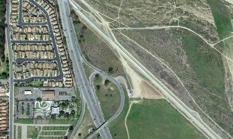
A 2021 aerial view shows no trace remaining of Machado Airfield.
Thanks to Dale Knutsen for pointing out this airfield.
____________________________________________________
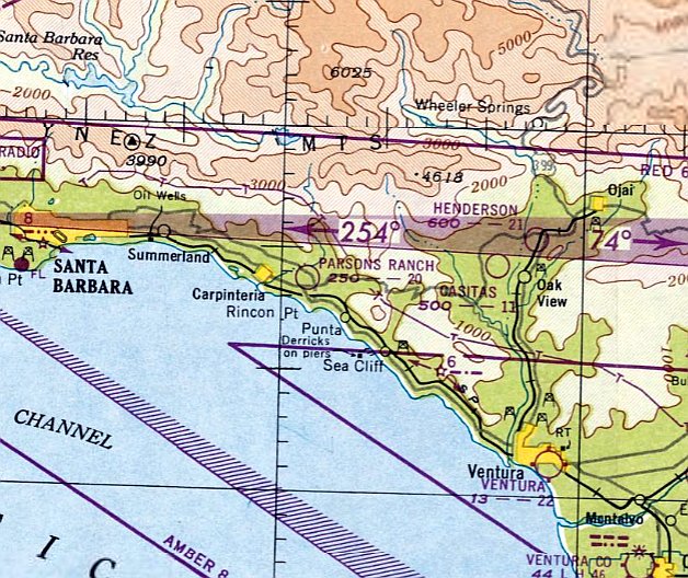
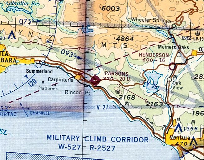
Parsons Airpark / Parsons Ranch Airpark, Carpinteria, CA
34.385, -119.478 (Northwest of Los Angeles, CA)
An 8/21/47 USGS aerial view of Parsons Airpark.
The date of establishment of Parsons Airpark has not been determined.
The earliest photo which has been located of Parsons Airpark was an 8/21/47 USGS aerial photo.
It depicted Parsons as having a single east/west runway with one small hangar on the northeast side.
Parsons Airpark was not yet depicted on the February 1948 LA Sectional Chart.
The earliest aeronautical chart depiction which has been located of Parsons Ranch Airpark was on the August 1948 Sectional Chart.
It depicted Parsons Ranch as having a 2,000' unpaved runway.
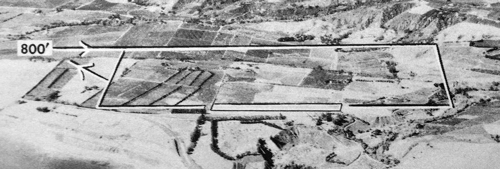
An undated aerial view looking north at Parsons Ranch Airpark from the 1950 Air Photo Guide (courtesy of Kevin Walsh).
The guide described Parsons Ranch Airpark as having a 2,000' sod Runway 8/26, and listed the manager as Louis Parsons.
The 1952 USGS topo map depicted “Parsons Ranch Airpark” as having a single east/west runway with 2 small buildings on the east side.
According to Monique Parsons (daughter of airport founder Louis Parsons),
“In the 1950s, movie stars would sometimes fly in on their way up to Santa Barbara.”
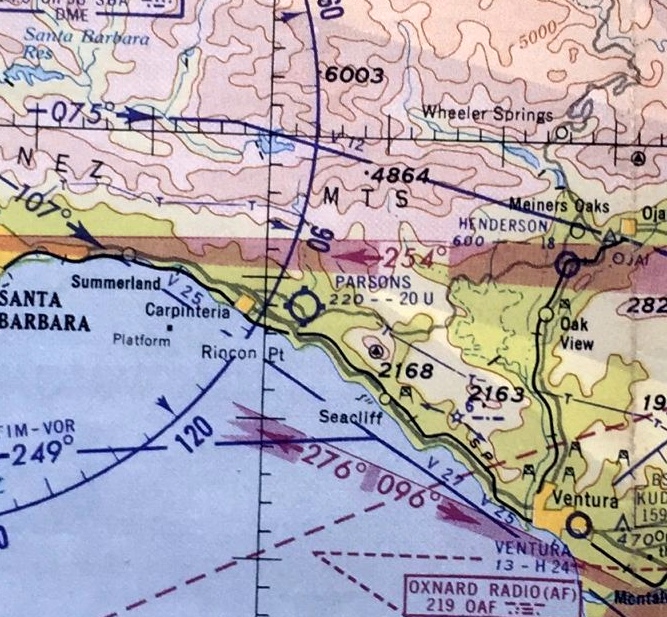
The March 1960 LA Sectional Chart depicted Parsons as having a 2,000' unpaved runway.
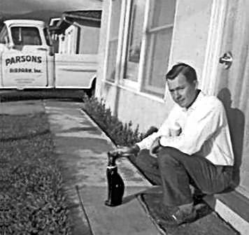
A November 1960 photo of airport founder Louis Parsons in front of a truck painted with "Parsons Airpark".
A 1/25/62 aerial view depicted Parsons Airpark having an asphalt Runway 08/26 with 5 small hangars on the northeast side.
Greg King reported, “I've been told that it was frequented by movie stars back in the day when they flew in to use the local beaches.”
Pierce Stewart recalled, “Parsons Airport was not far from the 'Thunderbowl',
a bowl-shaped dirt racetrack located just south of Carpenteria up on a bluff north of the famed 'Rincon' surfing spot.
Many pilots may have flown into Parsons & walked or gotten a ride to the track.”
Doug Dallam recalled, “Parsons Airpark was owned by Lou Parsons, and by 1965 or so it was defunct. Lou Parsons was my Dad's [Ray Dallam's] instructor.”
The last aeronautical chart depiction which has been located of Parsons Airpark was on the August 1966 LA Sectional Chart.
It depicted Parsons as a public-use airport having a 2,000' paved east/west runway.
Parsons Airpark was evidently closed (for reasons unknown) at some point between 1966-67,
as it was no longer depicted on the March 1967 LA Sectional Chart.
A 1967 aerial view depicted closed-runway “X” symbols on either end of the Parsons runway.
Doug Dallam recalled, “I remember going to Lou's in 1972 & staying at a trailer he had down on his runway.
The runway was overgrown & had not been used for 5-6 years by that time.”
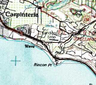
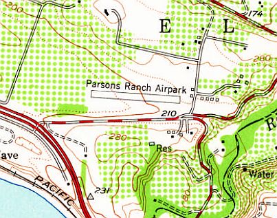
The 1978 USGS topo map depicted a single east/west runway, labeled simply as “Landing Strip”.
Parsons Airpark was no longer depicted at all on the 1988 USGS topo map.

A 9/3/94 USGS aerial view of the site of Parsons Airpark showed that although the outline of the runway was still intact, trees had sprouted up along the middle of the runway.
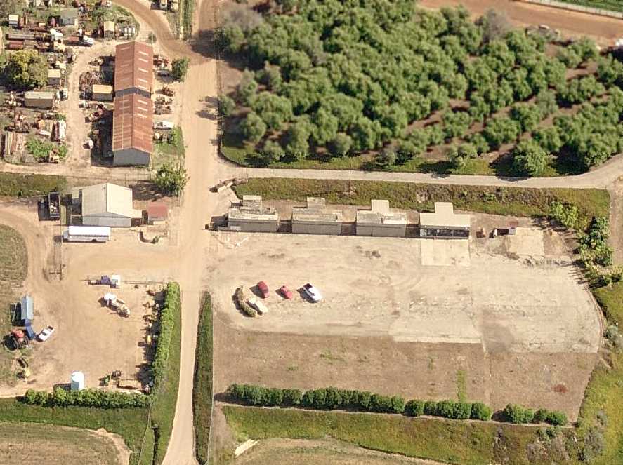
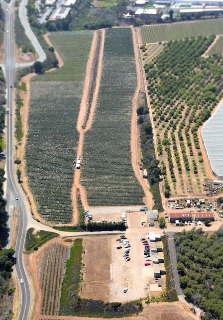
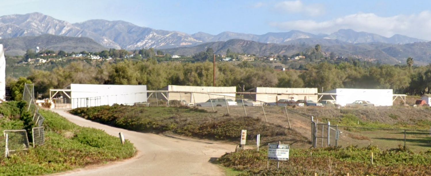
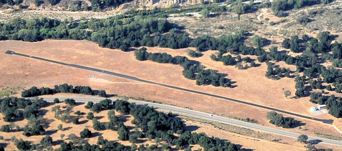
A circa 2006 aerial view looking north shows the unmistakable signs of a former airport,
with 4 former T-hangars on the east side of the ramp, and another hangar on the west side.
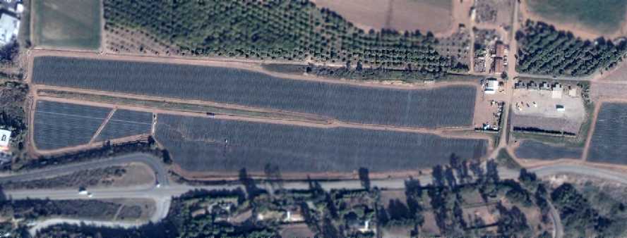
A 1/22/07 aerial view showed that all of the Parsons runway had been covered in crops, but the hangars remained intact.
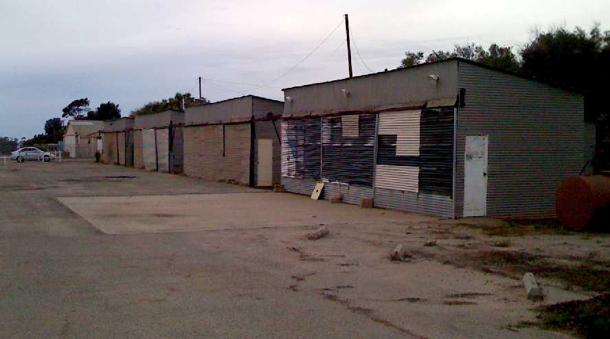
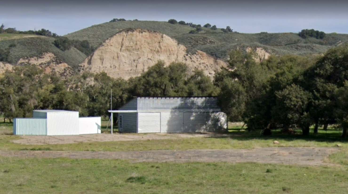
A 2009 photo by Greg King looking west at the T-hangars which remain at the site of Parsons Airpark.
Greg observed, “The airport is being used for agriculture now.”
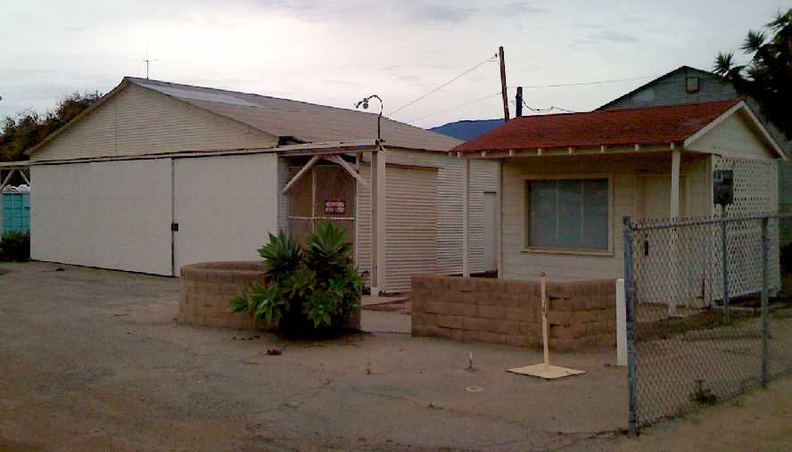
A 2009 photo by Greg King of the former main hangar & airport office of Parsons Airpark.
Greg remarked, “The location is beautiful, I wish this airport was still in service. It must have been a wonderful place to fly into back in the day.”
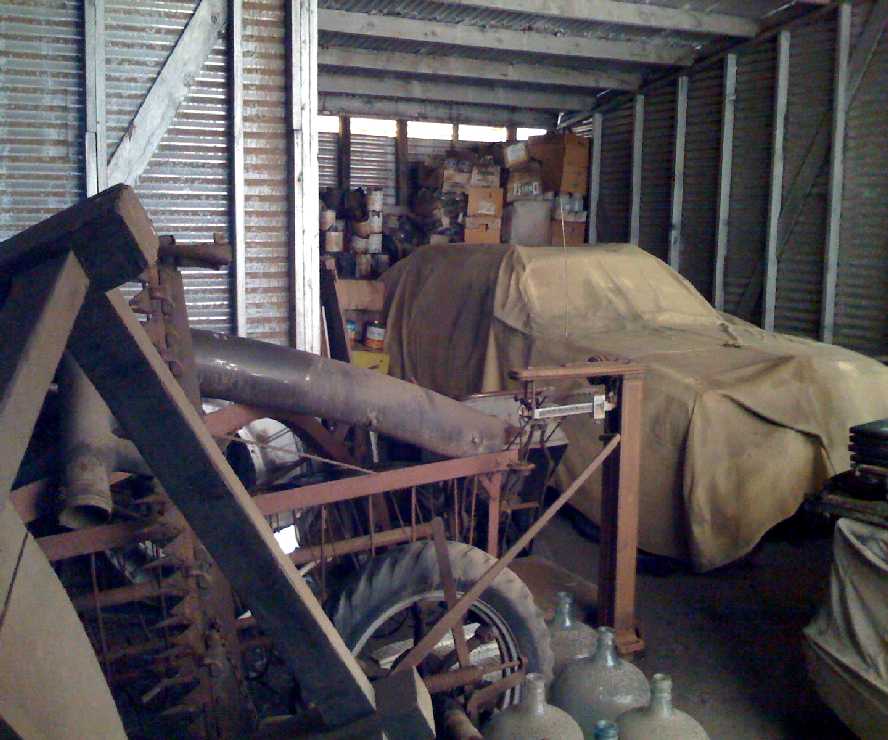
A 2009 photo by Greg King of the interior of a hangar at Parsons Airpark.
Greg observed, “There is an old car covered up in there, one or two of the other hangars had old cars in there as well, no airplanes though.”
A 6/2/15 aerial view of the remains of Parsons Airpark by John Wiley, “toward the West which would be the typical departure most days here.”
A 6/2/15 aerial view of the remains of Parsons Airpark by John Wiley, “toward the North of just the hangars,
and maybe those 2 buildings beyond the main hangar were associated with the airport when it closed in the 1960s.”
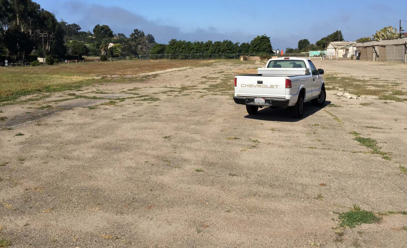
A 3/30/15 photo by Peter Carlson “of Parsons Airpark, looking down the length of the old runway, and it is still original asphalt from the runway.”
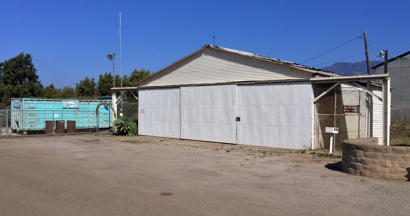
A 3/30/15 photo by Peter Carlson of the former main hangar of Parsons Airpark.
A 3/30/15 photo by Peter Carlson of the T-hangars which remain at the site of Parsons Airpark.
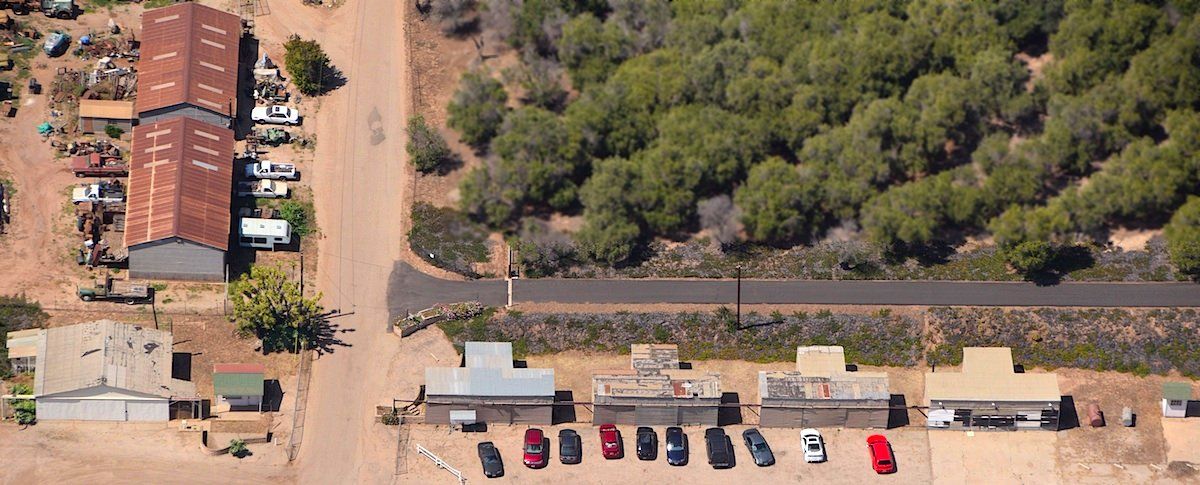
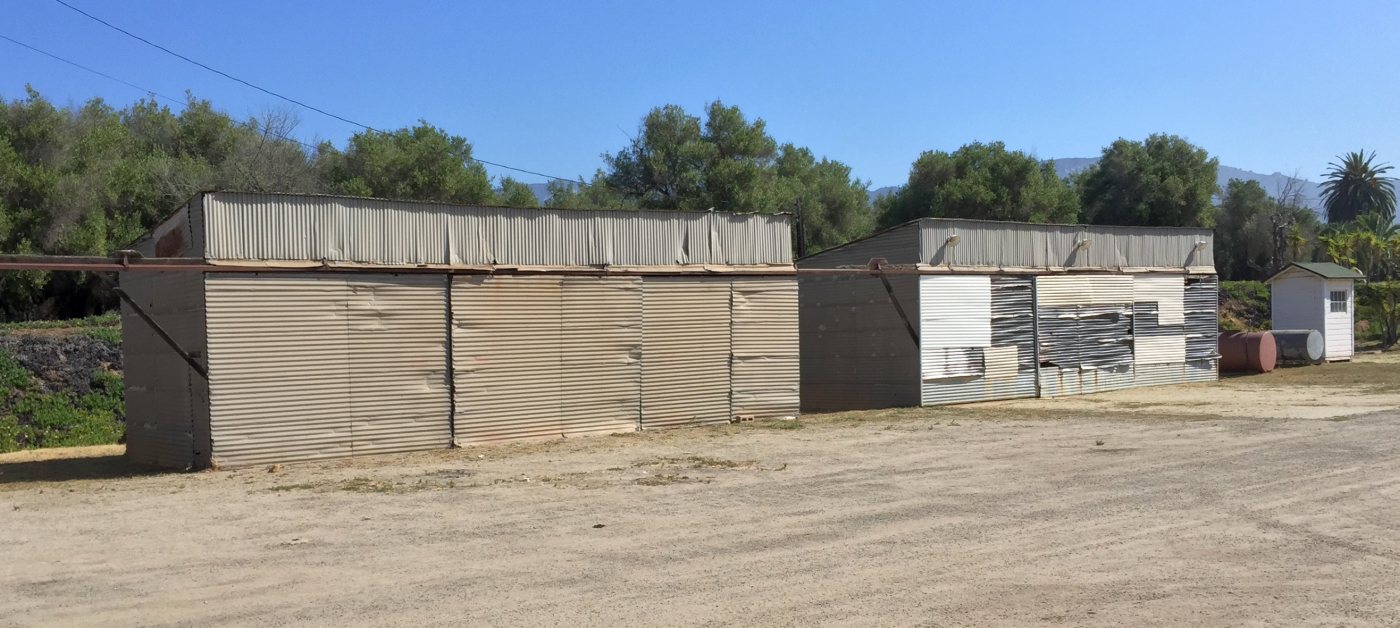
A 2022 photo looking northeast at the T-hangars which remain on the northeast side of the Parsons Airpark site.
The site of Parsons Airpark is located north of the intersection of Route 150 & Rincon Hill Road.
Thanks to Greg King for pointing out this airfield.
____________________________________________________
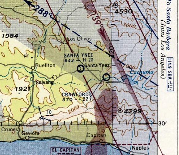
Crawford Airport (0CA3), Santa Barabara, CA
34.59, -120.016 (Northwest of Los Angeles, CA)
Crawford Airport, as depicted on the September 1945 San Francisco Sectional Chart.
This small general aviation airport was eventually established at some point between 1944-45,
as it was not yet depicted on the 1943 USGS topo map (courtesy of Dallam Oliver-Lee) or the August 1944 San Francisco Sectional Chart.
The earliest depiction which has been located of Crawford Airport was on the September 1945 San Francisco Sectional Chart.
It depicted Crawford as an auxiliary airfield.
The August 1948 San Francisco Sectional Chart depicted Crawford as having a 2,000' unpaved runway.
The 1948 USGS topo map (courtesy of Dallam Oliver-Lee) depicted Crawford as a commercial/municipal airport.
Note that it depicted Crawford on the south side of Route 150,
which may have been an error, as every subsequent depiction placed Crawford Airport on the north side of Route 150.
Or it is possible the airport was first located for a short period of time on the opposite side of the road.
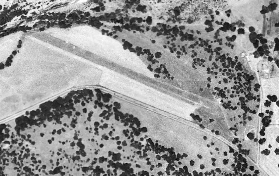
The earliest photo which has been located of Crawford Airport was on a 6/28/53 aerial view (courtesy of Dallam Oliver-Lee).
It depicted Crawford as a single unpaved northwest/southeast runway, on the north side of Route 150.
One small building (possibly a hangar) was located to the northeast.
The last aeronautical chart depiction which has been located of Crawford Airport was on the September 1956 San Francisco Sectional Chart.
It depicted Crawford as an auxiliary airfield.
Crawford Airport was evidently abandoned at some point between 1956-57,
as it was no longer depicted on the March 1957 San Francisco Sectional Chart.
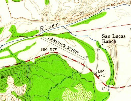
The 1959 USGS topo map (courtesy of Dallam Oliver-Lee) depicted Crawford Airport
as a single northwest/southeast 2,100' runway labeled simply as “Landing Strip”.
One small building (possibly a hangar) was located to the northeast of the hangar, and the San Luis Ranch was depicted a little father northeast.
A 1994 USGS aerial view (courtesy of Dallam Oliver-Lee) showed that Crawford Airport
had gained a paved runway & a 2nd small hangar at some point between 1959-94.
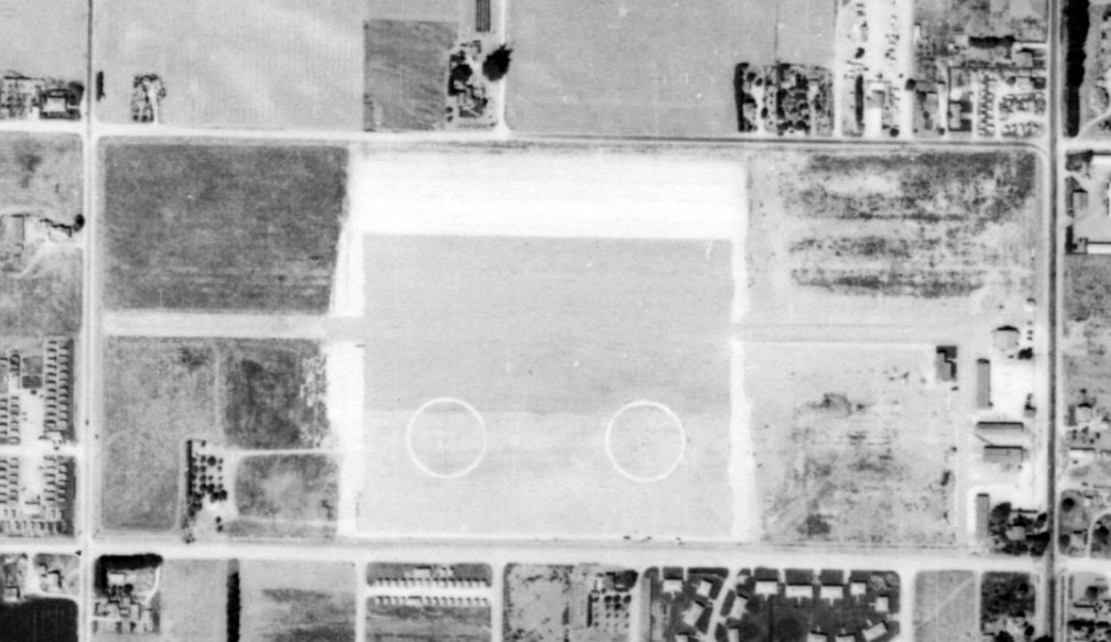
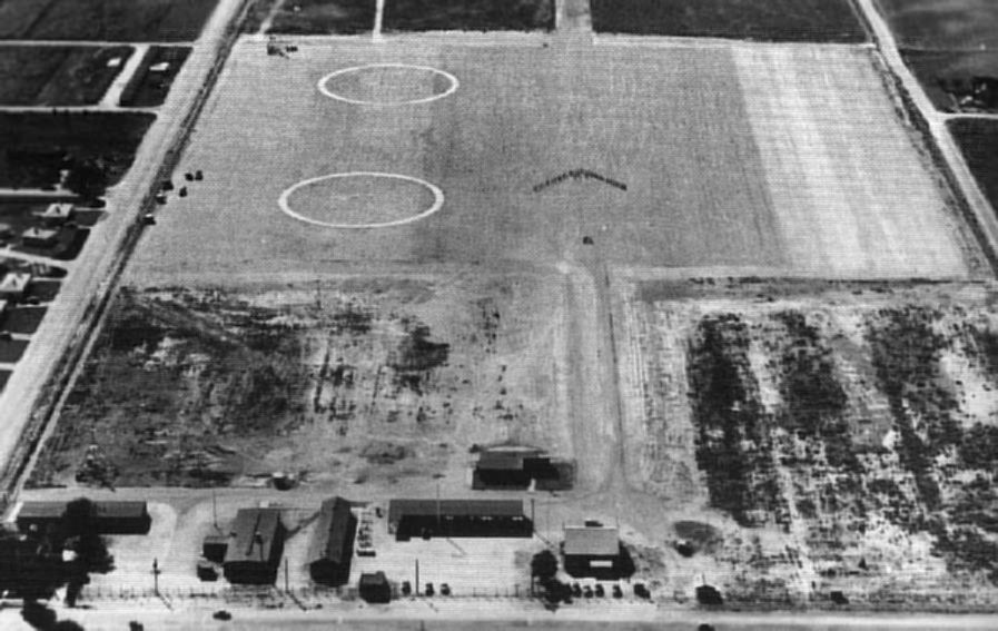
A 2002 USGS aerial view (courtesy of Dallam Oliver-Lee) showed that the Crawford Airport runway had been marked with closed-runway “X” symbols at either end,
and a short northwest portion of the runway had been widened for the use of a radio-controlled model aircraft club.
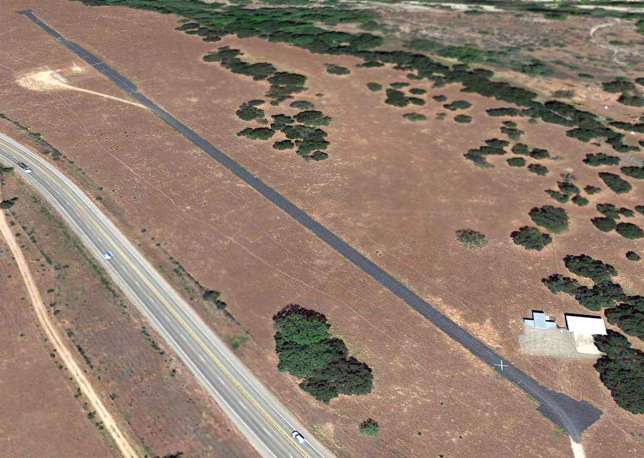
A 2013 aerial view looking northwest showed Crawford Airport & its 2 hangars to remain intact, though with closed-runway “X” symbols at either end of the runway.
An 11/26/14 aerial view by John Wiley looking southeast at Crawford Airport & its 2 hangars.
A March 2021 photo looking north at the east end of Crawford Airport's runway & its 2 hangars.
Crawford Airport is located northwest of the intersection of Route 154 & Cachuma Village Road.
Thanks to Dallam Oliver-Lee for pointing out this airfield.
____________________________________________________
Lompoc Airport (original location) / Lompoc NAAF, Lompoc, CA
34.648, -120.461 (Northwest of Los Angeles, CA)
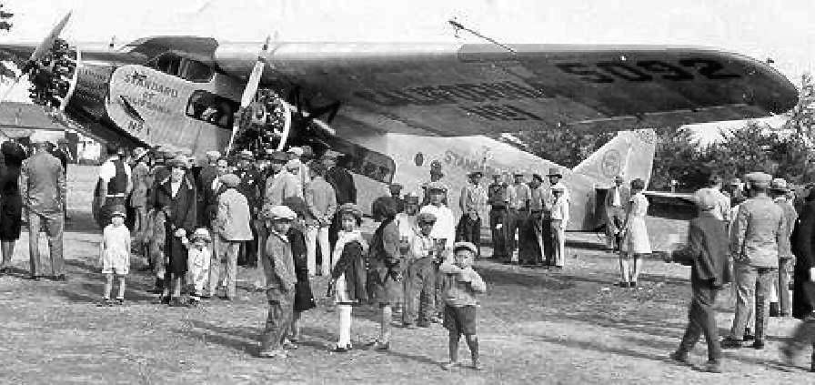
A 1928 photo of a Ford Tri-Motor owned by the Union Oil Company
at the Lompoc Airport on the occasion of the airport's dedication.
The Tri-Motor was the largest aircraft to have landed at the airport at that time.
The development of a municipal airport was first considered by the town of Lompoc in 1920.
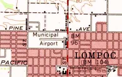
The airfield was eventually established in 1928, on land bordered by H Street & O Street, and College Avenue & Pine Avenue.
The earliest chart depiction which has been located of the Lompoc Airport
was on the 1933 San Francisco Airway Map (courtesy of Chris Kennedy)
It depicted Lompoc as a commercial or municipal airport.
The Airport Directory Company's 1937 Airports Directory (courtesy of Bob Rambo)
described the Lompoc Municipal Airport as having a rectangular 1,450' x 550' landing area,
with a hangar on the southeast side of the field.
Lompoc Airport as depicted on a 1938 street map (courtesy of Kevin Walsh).
A 1/21/38 aerial view (from the UCSB Library) depicted Lompoc Airport as having an unpaved east/west runway, with a hangar on the southeast side.
The December 1941 San Francisco Sectional Chart (courtesy of Chris Kennedy) depicted Lompoc as a commercial or municipal airport.
After the start of Word War II, a need was identified for an additional auxiliary field
to support antisubmarine blimp operations from NAS Santa Ana.
The Lompoc Airport site was chosen, and construction of expanded facilities began in 1942.
The station was commissioned in 1943 as Lompoc Naval Auxiliary Airfield.
Navy facilities consisted of a 1,000' x 500' asphalt landing mat, two blimp mooring masts, and barracks for a total of 97 personnel.
Five days after the commissioning of NAAF Lompoc, it suffered its only fatalities.
Four ground handlers were electrocuted when a blimp they were mooring came into proximity of a nearby high voltage power line.
A 9/21/43 aerial view showed Lompoc NAAF to have a single east/west runway, over which the square asphalt blimp mooring area had been built, on which were 2 blimp mooring markings.
Several buildings were on the east side of the field, but no aircraft were visible.
In this 1943 aerial view looking west at Lompoc NAAF (National Archives photo) the 2 blimp mooring rings were quite prominent.
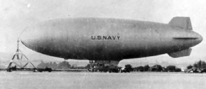
A circa 1943-45 photo of a Navy blimp moored at Lompoc.
A circa 1943-45 aerial view of a blimp at Lompoc (courtesy of Harry Gordon).
Typical operations at Lompoc during WW2 consisted of a 1 or 2 blimp detachment from Santa Ana's ZP-31.
"NAAF Lompoc (LTA)" was described by the 1944 US Army/Navy Directory of Airfields (courtesy of Ken Mercer)
as having a 1,000' hard-surface runway, with a dirigible mooring mast.
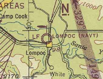
"Lompoc (Navy)", as depicted on the March 1945 San Francisco Sectional Chart (courtesy of Chris Kennedy). Note the blimp mooring mast symbol.
The 1945 AAF Airfield Directory (courtesy of Scott Murdock) described Lompoc Naval Auxiliary Air Facility
as a 65 acre irregularly-shaped property within which was a 1,000' square landing mat & a 2,400' east/west oiled shale runway.
The field was said to not have any hangars, to be owned by the U.S. Government, and operated by the Navy
The last Navy blimp departed Lompoc in late 1945, and the station was placed into caretaker status.
A June 1946 Department of Commerce Airman's Guide (according to Chris Kennedy)
redesignated “Lompoc NAAF (LTA)” to “Lompoc Airport”, as of 5/27/46.
At this point the airfield once again became Lompoc's municipal airport.
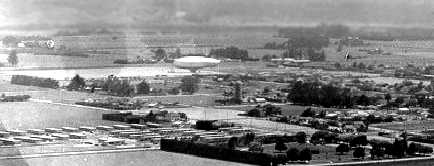
An undated aerial view looking east at the cluster of buildings on the east side of the original Lompoc Airport (courtesy of Harry Gordon).
An undated aerial view looking south at the original Lompoc Airport, with 2 of the blimp mooring circles visible at bottom-right (courtesy of Harry Gordon).
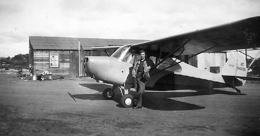
A 12/29/46 photo by Harry Gordon of his good friend John Bennett in front of an Aeronca at the original Lompoc Airport.
Harry recalled, “With a friend I rented an Aeronca Champion at Santa Barbara for a short cross-country to Lompoc Airport.
Neither of us had flown in the area before, and we apparently landed at the wrong field.
We found no facilities or airplanes and nobody there except a family living in a dilapidated building.
I think we were told that commercial operations had been moved to another Lompoc Airport.
I don't recall if the runway was dirt or old asphalt, but it was notably wavy, not flat.”
A 12/29/46 photo by Harry Gordon of the runway of the original Lompoc Airport, with his Aeronca parked in front of the former airport operations building.
What appears to be the framework of a former hangar (being dismantled?) was next to it.
The 1947 USGS topo map depicted the original Lompoc Airport as an open area with several small buildings on the east side of the field.
The original Lompoc Airport property was eventually overtaken by the rapid growth of the town of Lompoc.
The City purchased land 1.5 miles to the north, and established a new Lompoc Airport at that site at some point between 1945-51.
The last aeronautical chart depiction which has been located of the original Lompoc Airport was on the March 1951 San Francisco Sectional Chart.
Note that it also depicted the replacement Lompoc Airport, a mile to the northeast.
The original Lompoc Airport was closed at some point between 1951-55,
as it was no longer depicted on the September 1955 San Francisco Sectional Chart.
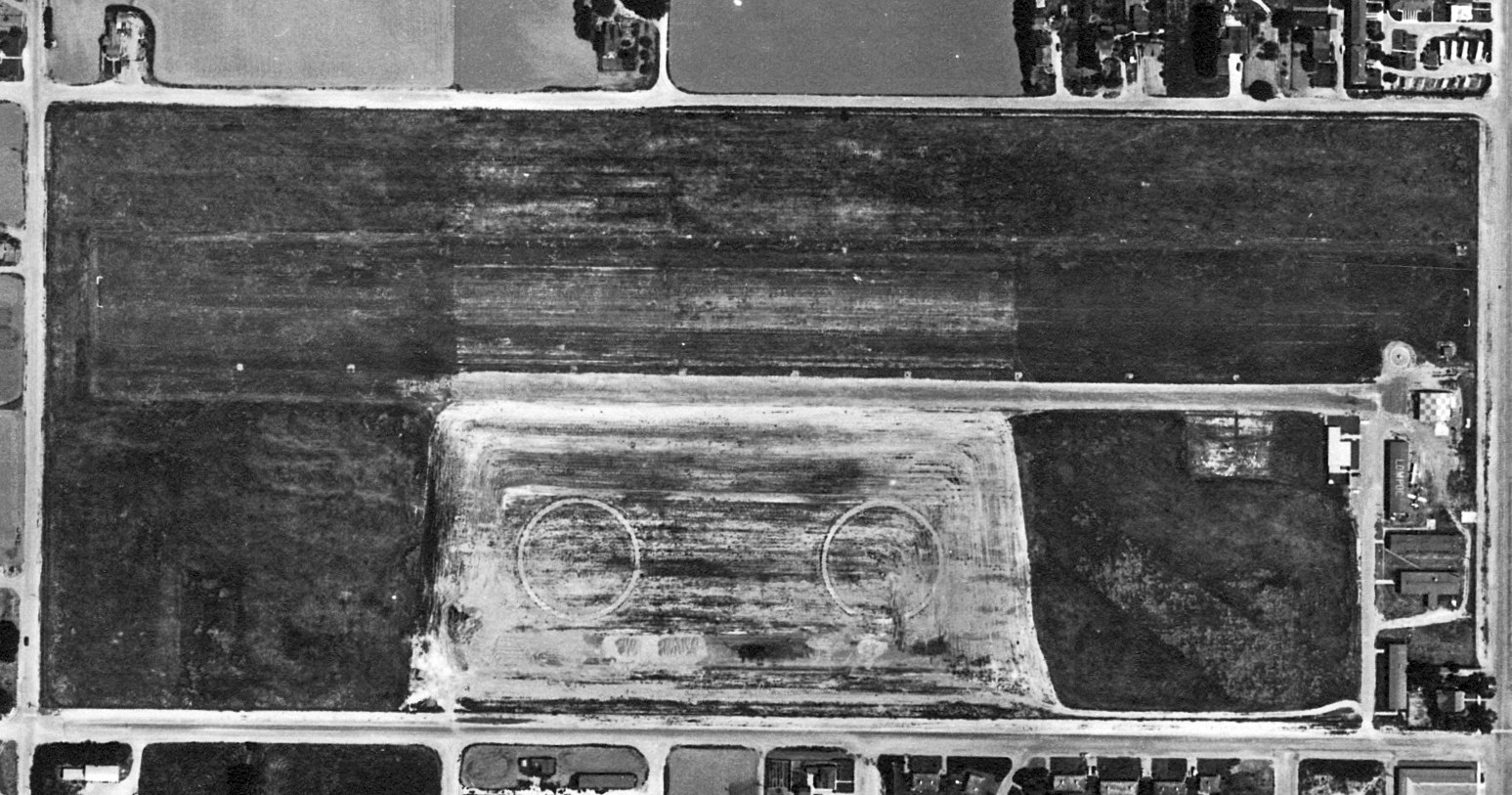
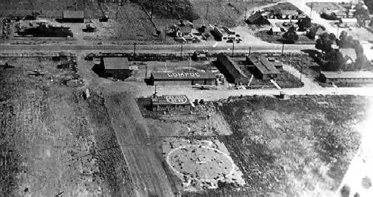
A 5/13/56 aerial view (from the UCSB Library) depicted the original Lompoc Airport as having an unpaved east/west runway, with the 2 former WW2 Navy blimp mooring circles still visible to the south.
Two hangars (one with a checkerboard roof, another with “Lompoc” painted on the roof) were located on the southeast side, along with 2 light single-engine planes.
The 1959 USGS topo map depicted the original Lompoc Airport as having a single east/west runway, with several small buildings on the east side of the field.
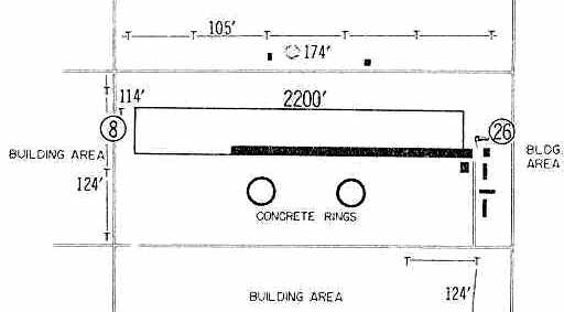
The 1960 Jeppesen Airway Manual (courtesy of Chris Kennedy) depicted the original Lompoc Airport as having a single 2,200' unpaved Runway 8/26,
which had a paved runway inset along the south side of the unpaved strip.
A cluster of buildings was depicted along the southeast corner of the field. The 2 concrete rings originally used for blimp mooring were still depicted as well.
The original Lompoc Airport as depicted on a 1960 street map (courtesy of Kevin Walsh).
The last depiction which has been located of the original Lompoc Airport was a 4/1/60 USGS aerial view.
The east/west runway was visible, as was the remains of the 2 concrete rings originally used for blimp mooring.
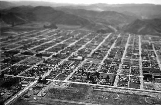
A 2003 photo by Tim Tyler of the site of the old Lompoc Airport.
Tim reported that the site is "Now the Lompoc High School (west end) with school buildings & numerous individual athletic fields."
Tim continued, "The large, modern strip mall is anchored by a Von’s, Sears, Big Lots, Staples, and smaller enterprises all along the east end.
Rainbow Plaza & Parkside Garden Apartments are on the northeast quadrant of the former NAAF, behind the strip mall."
Mike Loney reported in 2010, “Although the airport structures are all gone, one building remains from the Naval Auxiliary Air Field.
The housing area south of the field (across College Avenue) - where the cluster of trees are...
After the war, possibly after Korea, this area was acquired by the Housing Authority of Santa Barbara County for use as low-income housing.
It was extensively rebuilt by the early 1980s, but the former Station CO's HQ/Quarters building remains,
and is used by HACSB as the Lompoc area maintenance administration office.”
A 2012 aerial view shows the original Lompoc Airport site is now the location of Lompoc High School & a shopping center, with not a trace remaining of the former airport.
See also: http://www.ci.lompoc.ca.us/splash/airport.pdf
____________________________________________________
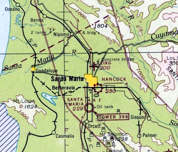
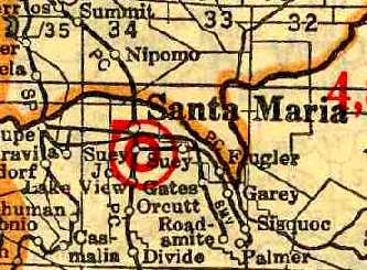
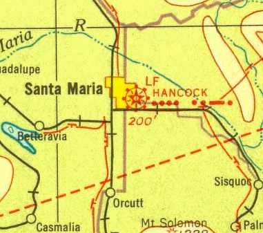
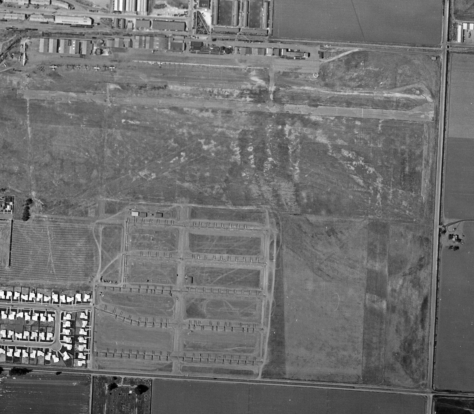
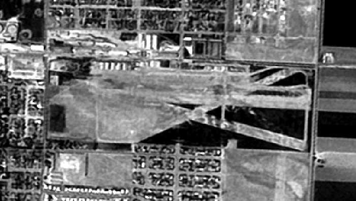
Santa Maria Airport / Hancock Field (original location), Santa Maria, CA
34.942, -120.424 (Northwest of Los Angeles, CA)
"Santa Maria" Airport, as depicted on the 1929 "Rand McNally Standard Map of CA With Air Trails" (courtesy of Chris Kennedy).
Hancock Field was founded in 1927 by Captain Allan Hancock. It was dedicated as the community's airport the following year.
The Hancock Foundation College of Aeronautics was established in 1928.
Ten-week classes were offered prospective pilot candidates, with successful individuals becoming licensed pilots.
Graduation of the first students occurred in 1929.
The 1929 "Rand McNally Standard Map of CA With Air Trails" (courtesy of Chris Kennedy)
described the Santa Maria Airport as a private airport, operated by Santa Maria Airlines, Inc., and that the field measured 2,680' x 500'.
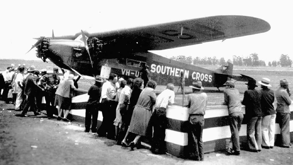
The "Southern Cross" Fokker Tri-motor, visiting Hancock Field in 1930.
The earliest chart depiction which has been located of Hancock Field was on the 1933 San Francisco Airway Map (courtesy of Chris Kennedy)
It depicted Hancock as a commercial or municipal airport.
The Airport Directory Company's 1937 Airports Directory (courtesy of Bob Rambo)
described Hancock Field as consisting of a 2,600' x 2,600' oiled landing area.
"Santa Maria" was painted on the roof of the western hangar, while "Hancock Field" was painted on the roof of the eastern hangar.
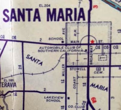
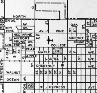
Hancock Field, as depicted on a 1938 street map (courtesy of Kevin Walsh) – the sideways “T” symbol southeast of the center of the town.
Just prior to the outbreak of WW2, the Hancock school was selected as one of 8 civilian institutions
to provide primary training to military aviation cadets.
This training began in 1939, just 40 days after Captain Hancock had met with General Arnold.
A 1940 street map (courtesy of Dallam Oliver-Lee) depicted Hancock Field as having 3 unpaved runways, with a row of buildings along the north side.
A 1940 aerial view (from the UCSB Library) depicted Hancock Field as having an asphalt east/west runway, with a larger grass airfield to the south.
A ramp along the north side had a large quantity of biplane trainers & a row of hangars.
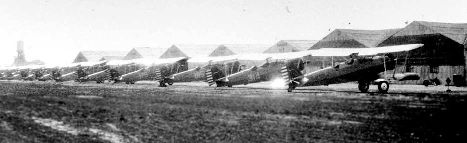
An undated view of Stearman trainers on the flightline at Hancock Field.
The December 1941 San Francisco Sectional Chart (courtesy of Chris Kennedy) depicted Hancock as a commercial or municipal airport.
An aerial view of a large number of biplanes lined up on the Hancock Field flightline (courtesy of Tim Tyler).
According to Bill McKee, this photo is pre-1942. "The fairgrounds in the lower right of the photo were removed that year to allow for expansion of the field.
The buildings look pre-war from other photos I have. Student barracks were added in 1940 & these are not on this photo, for instance."
An undated view of biplane trainers on the flightline at Hancock Field (courtesy of Dee Dee Benford, Santa Maria Historical Museum).
According to Bill McKee, "This is an early-war [WW2] view of the lineup of PT-13 Stearman trainers
before a larger influx of these really made for a large sized contingent on the ramp."
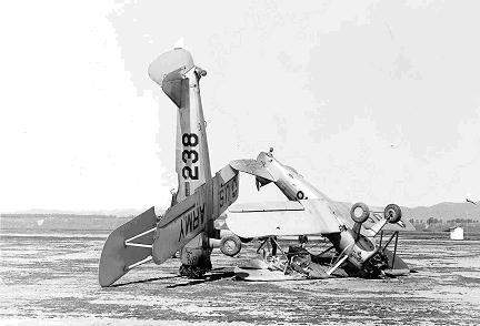
A 1942 photo of two Stearman trainers from Hancock Field which had collided (courtesy of Bill McKee).
"Note that markings are not standard, which was usually the case of these aircraft provided by the Army & maintained by the contractor."
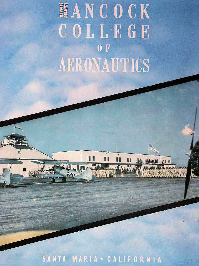
An undated Hancock Yearbook, a publication of the Hancock School of Aeronautics (courtesy of Tim Tyler).
According to the USAAF History of AAFTD-1 (from the Air Force Historical Research Archives, according to Bill Kee),
the predominant trainer aircraft used at Hancock Field was the Stearman PT-13 biplane.
Rarely a week would pass without a crash.
Forced landings were common in the Santa Maria Valley, with pilots often needing to make emergency landings in the dry Santa Maria riverbed.
According to Wikipedia, Hancock Field was supported by the following auxiliary airfields during WW2:
Santa Maria Auxiliary Field (N 34°48′24″ W 120°26′03″), La Brea Auxiliary Field (N 34°52′52″ W 120°17′36″), Mckinnon Auxiliary Field (location undetermined),
Souza Auxiliary Field (N 34°59′39″ W 120°28′50″), and Waller-Franklin Auxiliary Field (N 34°55′57″ W 120°31′46″).
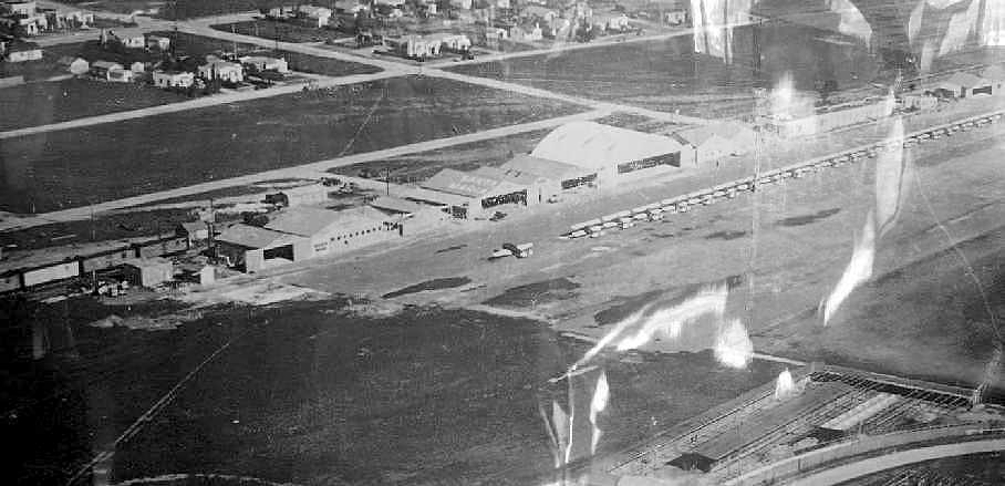
A 7/23/43 aerial view looking north from the 1945 AAF Airfield Directory (courtesy of Scott Murdock)
depicted Hancock Field as having a rectangular landing area with a ramp & buildings along the north side.
The August 1943 San Francisco Sectional Chart depicted Hancock Field as a commercial/municipal airport.
Ken Barber recalled that Hancock Field was “my primary flight school where I first soloed the PT-13 Stearman.
I started flying there right after preflight at Santa Ana Army Air Base in Orange County
where after a strenuous evaluation was selected for pilot training & sent off to Santa Maria in September 1943.
I actually soloed at an auxiliary field at Guadalupe which was over toward the coast.
We also used other auxiliary fields for other purposes.
I have very pleasant memories of The Hancock College of Aeronautics
and have a special graduation certificate showing that I indeed graduated from that specific school.
Santa Maria was considered to be the country club of the primary flight schools in the Western Flying training command.”
"Hancock, Army" was described by the 1944 US Army/Navy Directory of Airfields (courtesy of Ken Mercer) as having a 3,300' hard-surface runway,
although the remarks included, "3,900' turfed landing area available."
A 10/23/44 aerial photo (courtesy of Dallam Oliver-Lee) depicted Hancock Field as having an unpaved airfield with a row of buildings along the north side.
Military flight training at Hancock Field continued until 1944.
Hancock Field was depicted as a commercial/municipal field on the March 1945 San Francisco Sectional Chart (courtesy of Chris Kennedy).
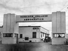
An undated photo of the gate of the Hancock College of Aeronautics.
The 1945 AAF Airfield Directory (courtesy of Scott Murdock) described Hancock Field
as a 225 acre irregularly-shaped property within which was a 3,310' east/west asphalt runway
and a 3,900' x 2,600' all-way sod landing area.
The field was said to have six 65' x 48' wood & metal hangars, and to be privately owned & operated.
After the war Hancock Flight School was leased to USC for use as a 4-year Aeronautics Degree program.
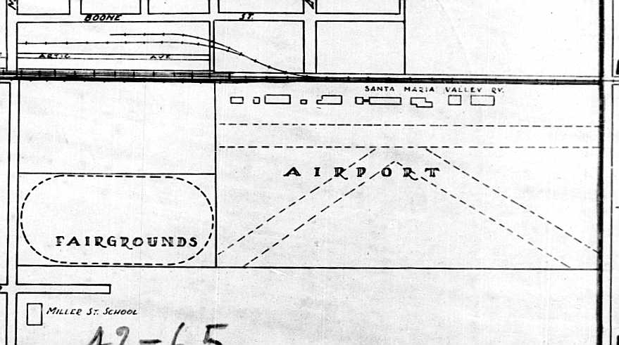
The 1947 USGS topo map depicted Hancock Airport as having 3 paved runways & taxiways, with buildings along the north side.
The February 1947 San Francisco Sectional Chart depicted Hancock Field as a commercial/municipal airport.
A circa 1940s photo looking southwest along Hancock Field depicted a Douglas DC-3 & several othr hangar parked on the north side.
The January 1948 San Francisco Sectional Chart (according to Dean Billing) depicted Hancock as having a 3,400' hard-surface runway.
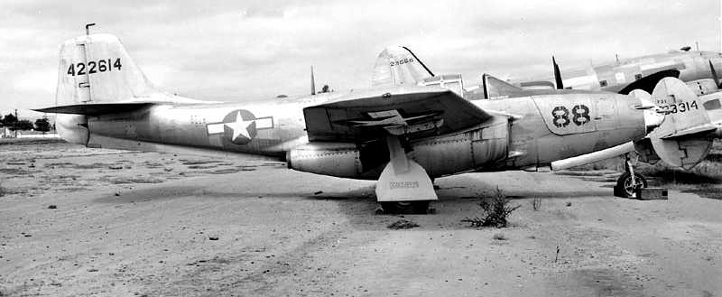
An August 1949 photo by Bill Larkins of a historic Bell P-59A (44-22614) which was languishing at the Hancock College of Aeronautics.
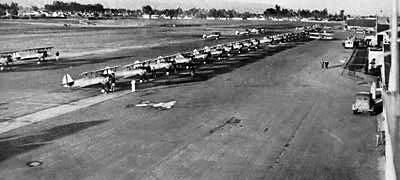
An undated aerial view looking north at Hancock Field from the 1950 Air Photo Guide (courtesy of Kevin Walsh).
The guide described Hancock Field as having 3 runways, with the longest being the 3,800' graded Runway 10/28.
It listed the manager as James Stone.
During the Korean War the Hancock school was used to train aviation mechanics.
The last photo which has been located showing aircraft at Hancock Field was a 5/26/52 aerial view (from the UCSB Library).
The runway pavement was considerably deteriorated, but there were a dozen aircraft visible on the ramp, including one large 4-engine transport or bomber (model unidentified).
In 1954 Santa Maria Junior College purchased the 40 acre airport site
and began construction of what is still operated today as the Allan Hancock Community College.
However, apparently Hancock Field still continued to operate as an airfield,
as it was still depicted as an active airfield on the 1955 & 1956 San Francisco Sectional Charts (according to Chris Kennedy).
The Aerodromes table listed the airfield as having 3 runways, with the longest being a 3,300' "road mix" strip.
The last photo which has been located of Hancock Field while it was still open was on a 6/27/56 USGS aerial view (courtesy of Dallam Oliver-Lee).
It depicted Hancock Field as having 3 runways.
The last aeronautical chart depiction which has been located of Hancock Field
was on the September 1957 San Francisco Sectional Charts (courtesy of Dale Knutsen).
It depicted Hancock Field as having a 3,300' paved runway.
Ross Mayfield reported, “Hangars & several buildings were featured in the film 'Spirit Of St. Louis' starring Jimmy Stewart [released in 1957].
Many of the aviation scenes in the film that take place prior to the flight to Paris were filmed at Hancock Field."
Dale Knutsen recalled, “The old control tower at Hancock Field was used by the Ground Observer Corps, a USAF auxiliary,
as an observation & listening post for the network of volunteer-operated early warning stations along the west coast.
I was one of the members of the GOC that manned that post, which was designated Quebec Echo 35 Black, and which reported by telephone to a central site in Pasadena, CA.”
Hancock Field was apparently closed at some point between 1957-58,
as it was no longer depicted on the April 1958 San Francisco Sectional Chart.

The 1959 USGS topo map depicted the buildings of Allen Hancock College, but Hancock Field was no longer depicted.
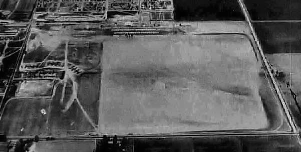
A 4/1/60 USGS aerial view (courtesy of Dallam Oliver-Lee) appeared to show Hancock Field remaining largely still intact.
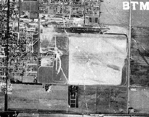
A 7/5/61 USGS aerial view (courtesy of Dallam Oliver-Lee) showed buildings starting to cover the airfield area of Hancock Field.
Hancock Field was no longer depicted at all on the 1966 San Francisco Sectional Chart.
A 9/2/78 USGS aerial view (courtesy of Dallam Oliver-Lee) showed that buildings had covered the site of Hancock Field's runways at some point between 1960-78.
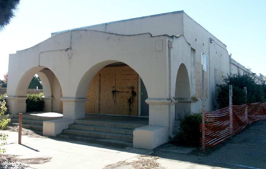
A 2003 photo by Tim Tyler of "Building Y", which appears to date from the Hancock Field days.
Tim Tyler visited the site of Hancock Field in 2003, and reported, "Building ‘S’ is a long, 1 story wooden structure
that has a signature of perhaps dating back from the airfield days (warehouse, barracks, etc.).
The windows are now boarded up, and it looks like it most recently housed the college’s Academic Affairs offices.
Another college building that looks to be from the Hancock Field days is known as Building Y.
It is a concrete building with minor mission-style architecture, all boarded up now.
Building Z is apparently in use as the Student - Child Study Center,
and is located along College in between Oak & Park Avenues.
It looks to be of similar age & design to Building Y.
Sadly, Allan Hancock College doesn’t seem to offer any aviation related classes these days."
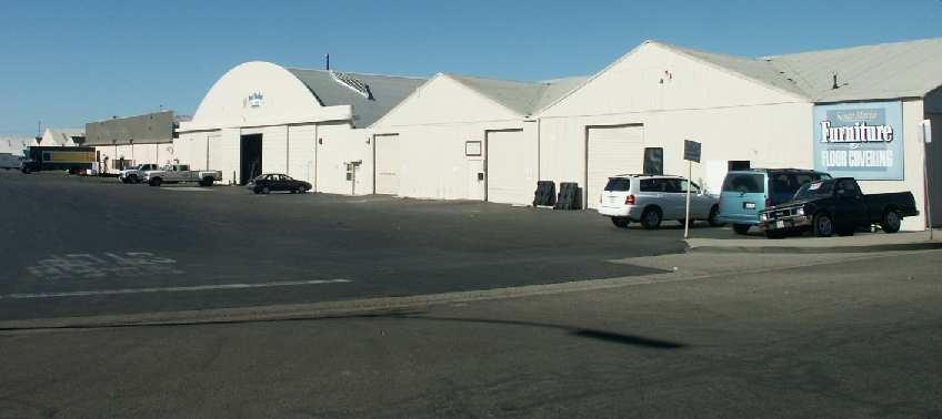
A 2003 photo by Tim Tyler of former hangars which remain at the site of Hancock Field.
Tim continued, "Many or perhaps all of the large old hangars are on East Oak Street & Arctic Avenue,
just West on the other side of College Street from Hancock College,
and are now in use by Santa Maria Furniture & Floor Covering,
Los Padres Glass & Mirror Co, Pacific Auction, Jim Agawa Radiator Service, Custom Rod & Tackle Co,
Central Coast Spring & Alignment, Sawyer Building Material, German Joe’s Mobile Repair & Custom BBQs.
Other than a couple obvious hangars off of East Oak Street, I don’t know for sure how many of these old structures date back to the Hancock Field days,
but they do look to be from the right era."
Ross Mayfield reported in 2004, "I live near & work in Santa Maria.
We used to have a business located in one the hangars west of the college.
I can tell you that almost all of the buildings on that portion of Oak street, west of the college
(except for the concrete building on the south side that sits next to College Avenue) are all former Hancock Field Hangars.
There are also 4 hangar buildings from the original Hancock field that were relocated to Santa Maria Airport.
In the hangar that we were located in, up in the rafters
was a sign stating that no responsibility was claimed for items left inside of aircraft parked there."
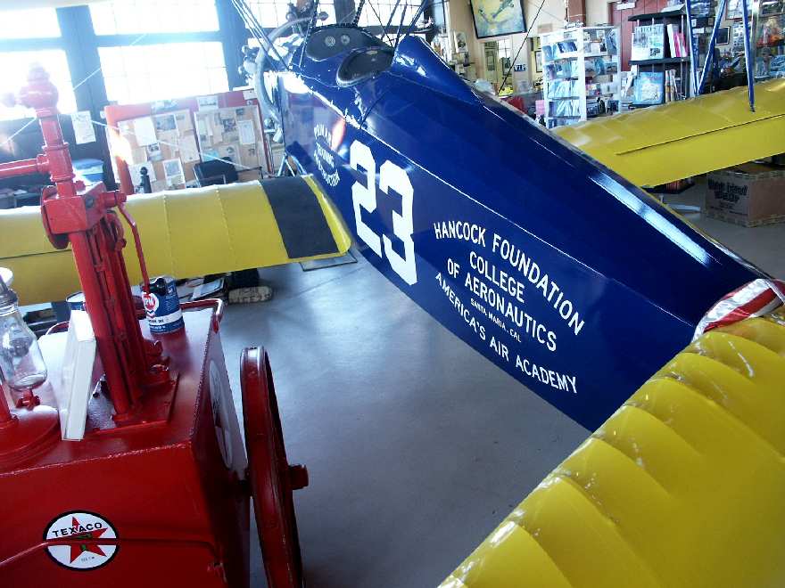
A 2003 photo by Tim Tyler of a biplane marked “Hancock Foundation College of Aeronautics”.
According to Bill McKee, this aircraft is a Fleet 2 which was procured in Florida
and then flown to the Santa Maria Museum of Flight where it was restored in colors & markings
accurate to aircraft flown by the Hancock Foundation College of Aeronautics in the early 1930s.
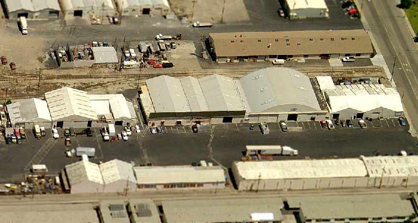
A 2006 aerial view looking north at the row of 60-year-old hangars which remain at the site of the original Hancock Field.
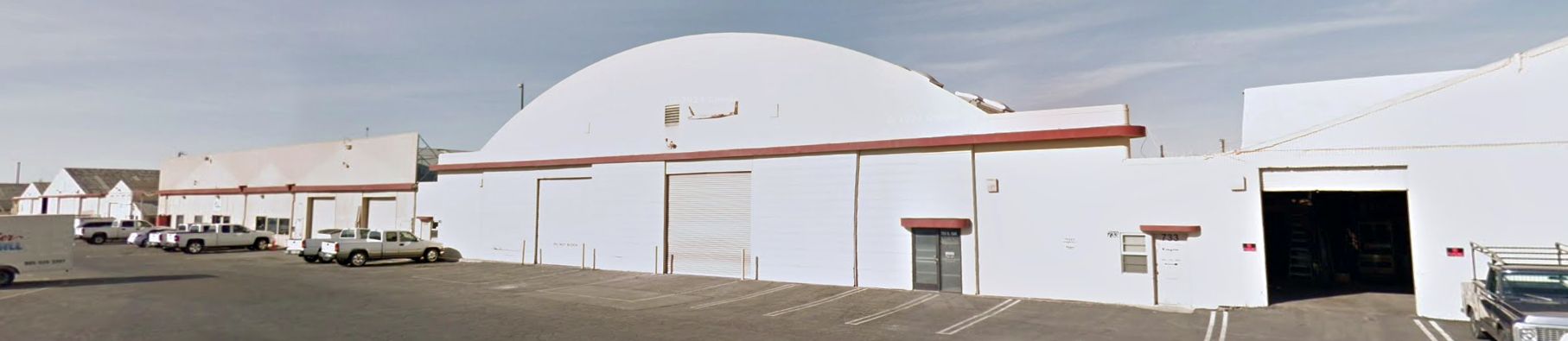
A 2012 photo looking northwest at the row of 70-year-old hangars which remain along the north side of the original Hancock Field site.
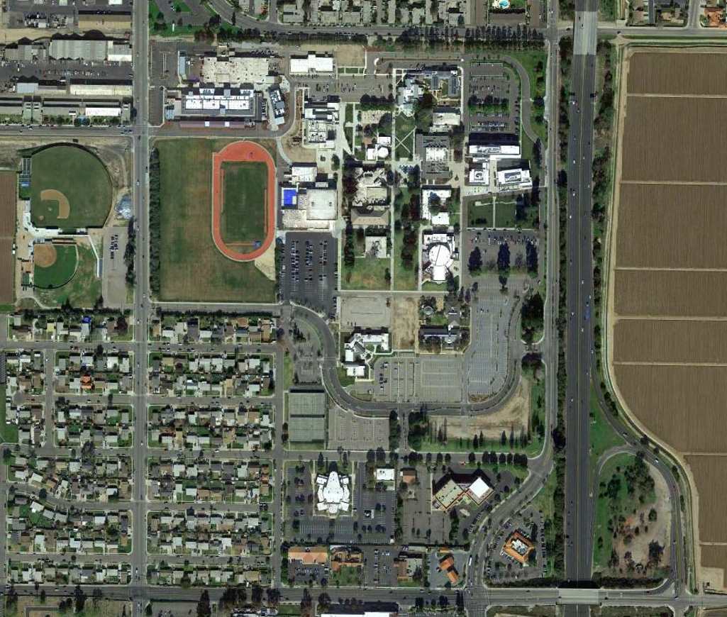
A 2015 aerial view of the site of Hancock Field, since reused as the Allan Hancock Community College.
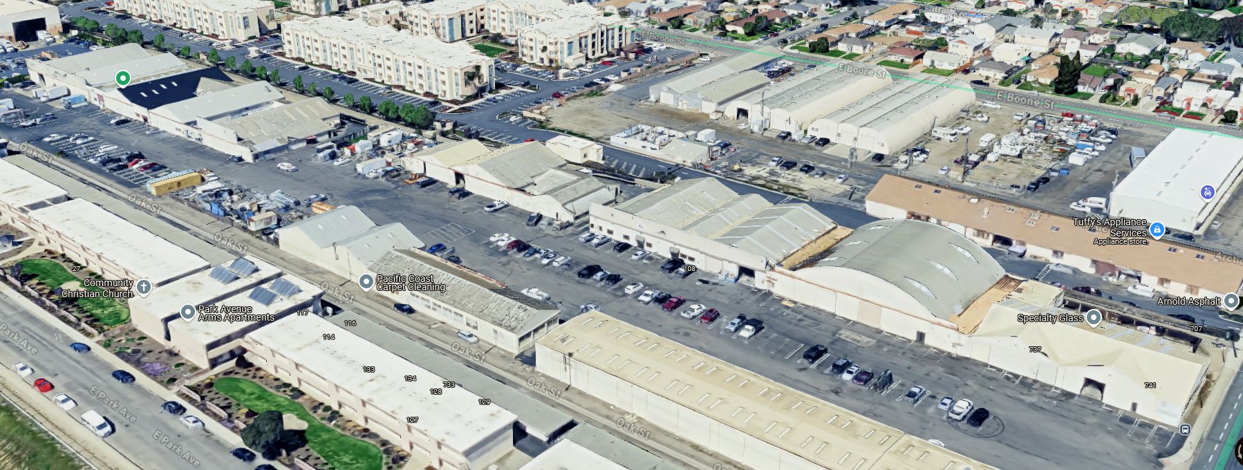
A 2024 3-D aerial image looking northwest at the row of 80-year-old hangars which remain along the north side of the original Hancock Field site.
The name Hancock Field lives on today, as the much larger Santa Maria Airport (several miles southwest of the original Hancock Field) has adopted the name Hancock Field.
The Santa Maria Museum of Flight is located at the Santa Maria Airport.
See also:
http://www.smmof.org/history.htm
http://www.countyconnections.org/projects/shaw/aviation/field.htm
____________________________________________________
____________________________________________________
This site covers airfields in all 50 states.