
Abandoned & Little-Known Airfields:
California: Mojave Area
© 2002, © 2023 by Paul Freeman. Revised 9/16/23.
This site covers airfields in all 50 states: Click here for the site's main menu.
____________________________________________________
Please consider a financial contribution to support the continued growth & operation of this site.
For a 10th year, the CA pages of this website are sponsored by the California Pilots Association:
Boron AF Plant #72 Airfield (revised 3/26/17) - Cuddeback Dry Lake Landing Strip (revised 12/8/19)
Gypsy Springs Airfield (revised 5/27/19) - Harper Dry Lake Airfield (revised 3/20/22) - Hawes Aux AAF #1 (revised 12/8/19) - Myer Field (revised 7/6/18)
Mojave Inyo Airport (revised 10/15/15) - Pancho Barnes Airfield (revised 9/16/23) - US Borax Airfield (revised 9/16/23)
____________________________________________________
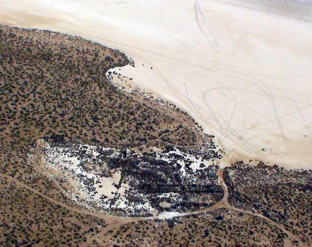
US Borax Airfield, Rio Tinto, CA
35.03, -117.708 (Northeast of Edwards AFB, CA)
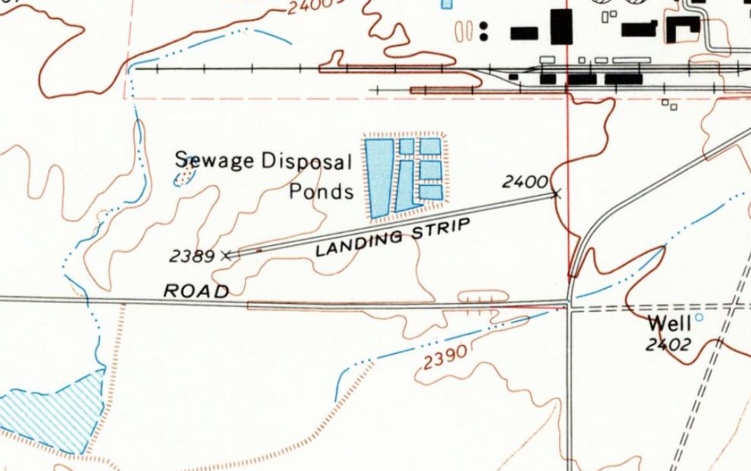
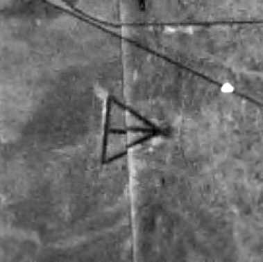
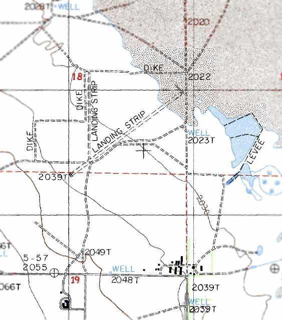
The US Borax Airfield, as depicted on the 1973 USGS topo map.
Photo of the airfield while in use is not available.
This industrial airfield was evidently established at some point between 1969-72,
as it was not yet depicted on a 1952 aerial photo or on the March 1969 LA Sectional Chart.
The earliest depiction which has been located of the US Borax Airfield was a 1972 aerial view.
It depicted a single asphalt northeast/southwest runway. There were no other improvements at the airfield, nor any aircraft.
The earliest depiction which is available of the US Borax Airfield was on the 1973 USGS topo map.
It depicted a single paved northeast/southwest runway, labeled generically as “Landing Strip”.
The earliest aeronautical chart depiction which has been located of the US Borax Airfield was on the January 1976 LA Sectional Chart (courtesy of Ron Plante).
It depicted Borax as a private airfield having a single paved 4,000' northeast/southwest runway.
Note the Borax Airfield's close proximity to the numerous Edwards AFB runways to the southwest.
The earliest photo which is available of the US Borax Airfield was a 1994 USGS aerial view looking northwest.
It depicted Borax as having a single paved Runway 6/24, with a paved ramp & helipad on the east side.
There were no other improvements at the airfield, nor any aircraft.
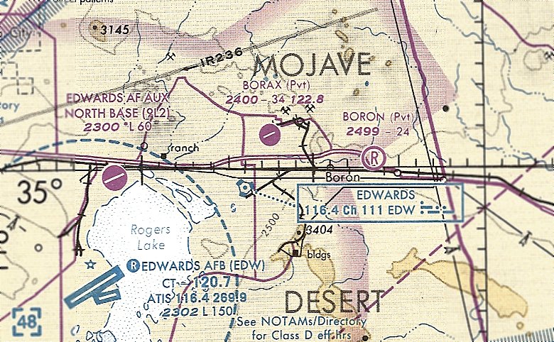
The last aeronautical chart depiction which has been located of the US Borax Airfield was on the January 1998 LA Sectional Chart (courtesy of Ron Plante).
It depicted Borax as a private airfield having a single paved 3,400' northeast/southwest runway.
Borax Airfield was still depicted on the 2012 USGS topo map.
Borax Airfield was no longer depicted on the 2015 USGS topo map.
The US Borax Airfield was evidently closed (for reasons unknown) at some point between 1998-2016,
as it was no longer depicted on the 2016 LA Sectional Chart.
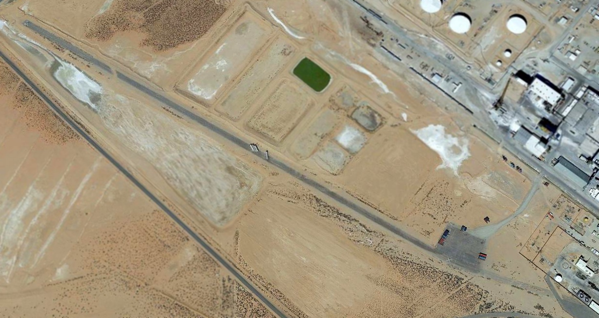
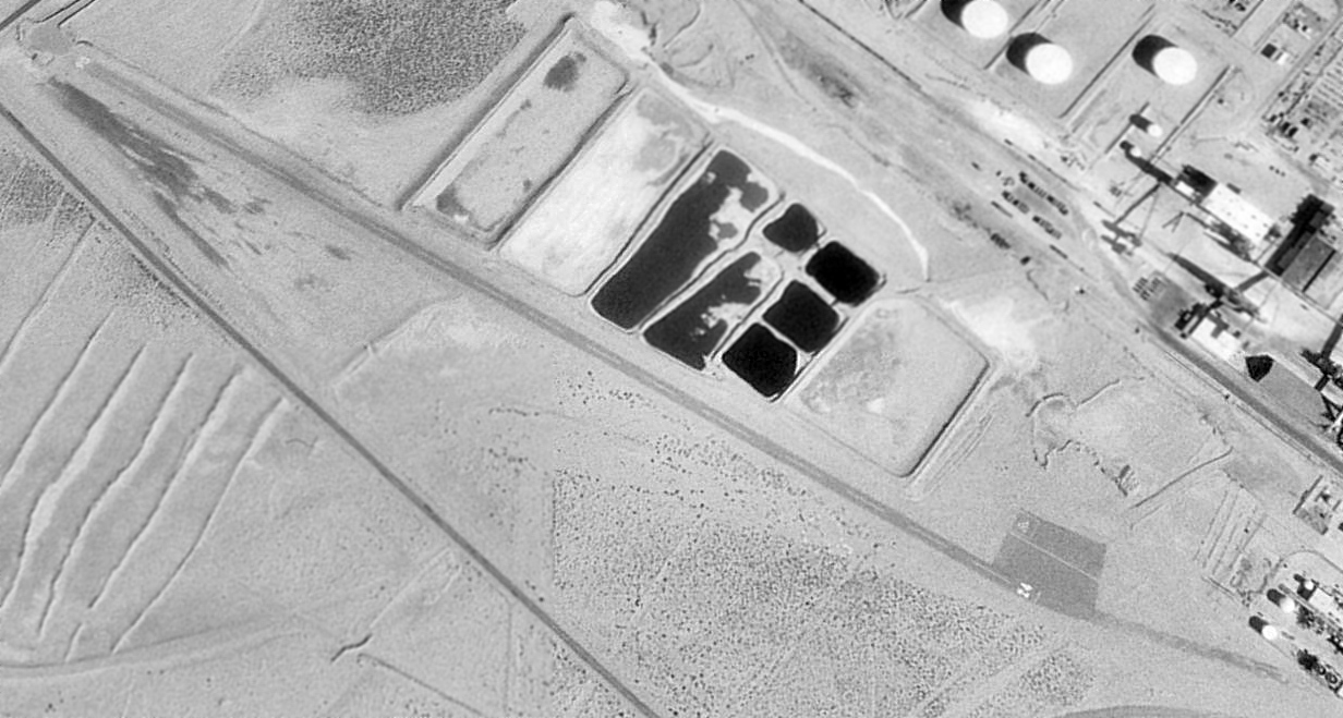
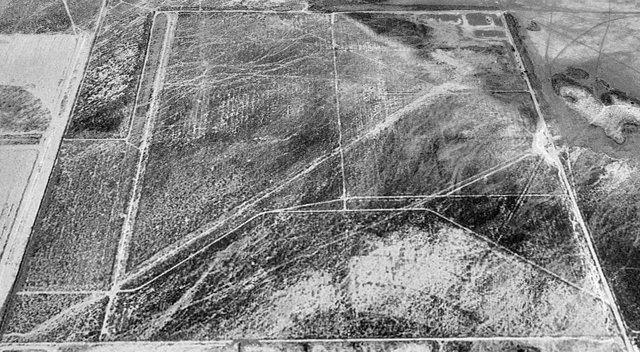
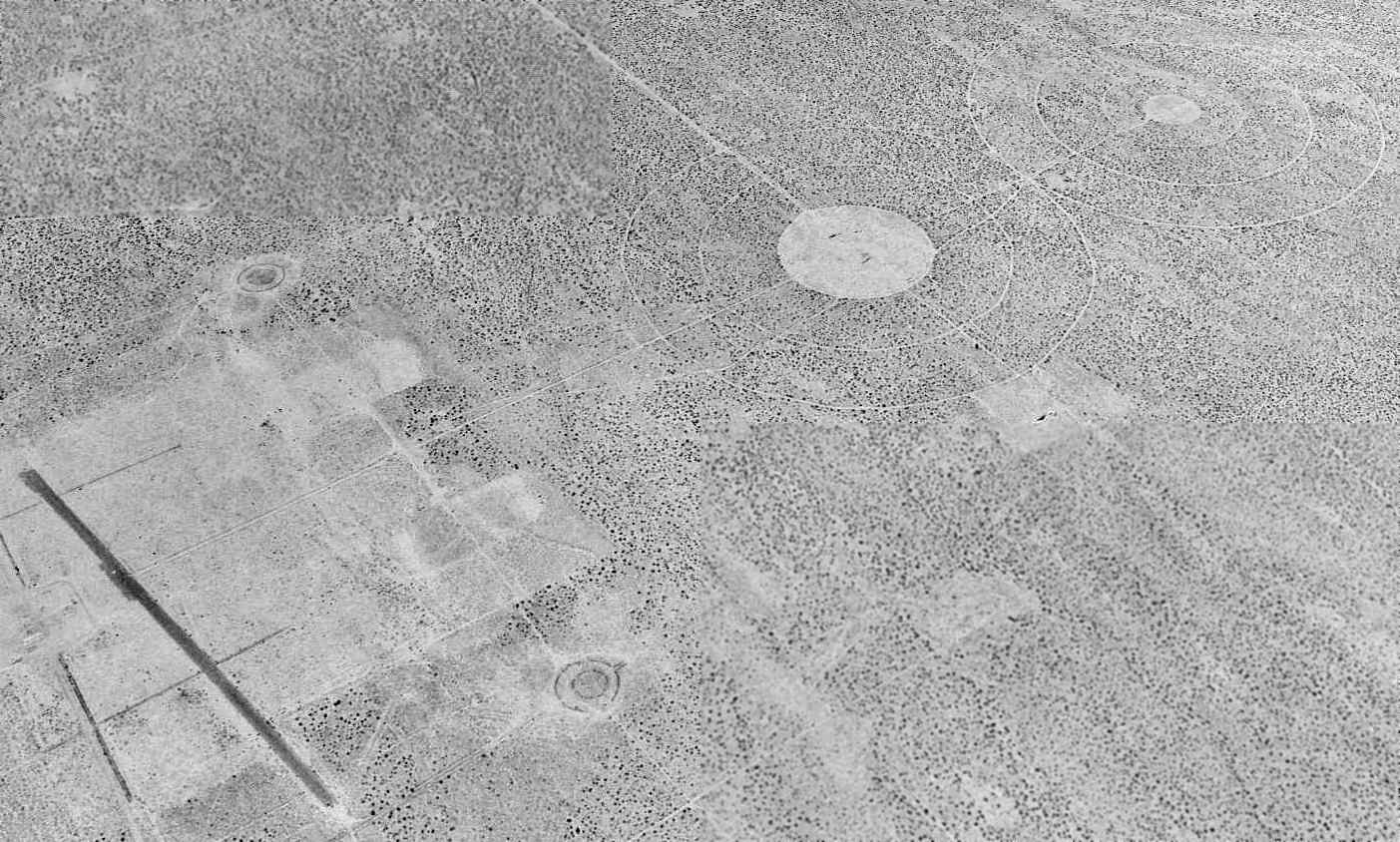
A 2015 aerial view looking northwest showed the US Borax Airfield remained intact, but with the runway marked with closed-runway “X” symbols at each end.
Trailers were parked on the midpoint of the runway, presumably to preclude unauthorized landings.
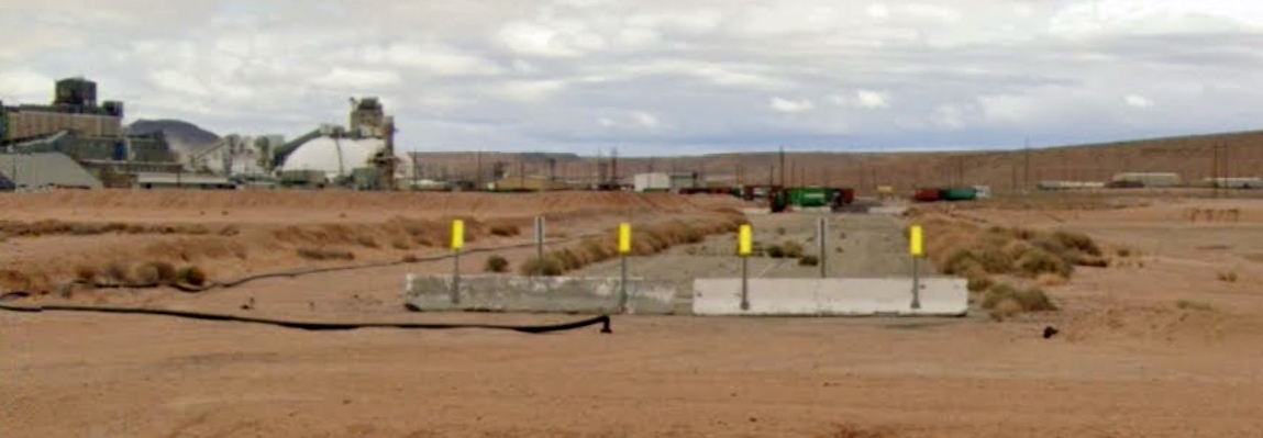
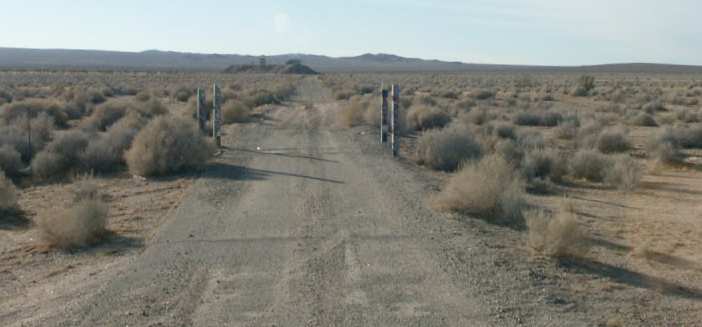
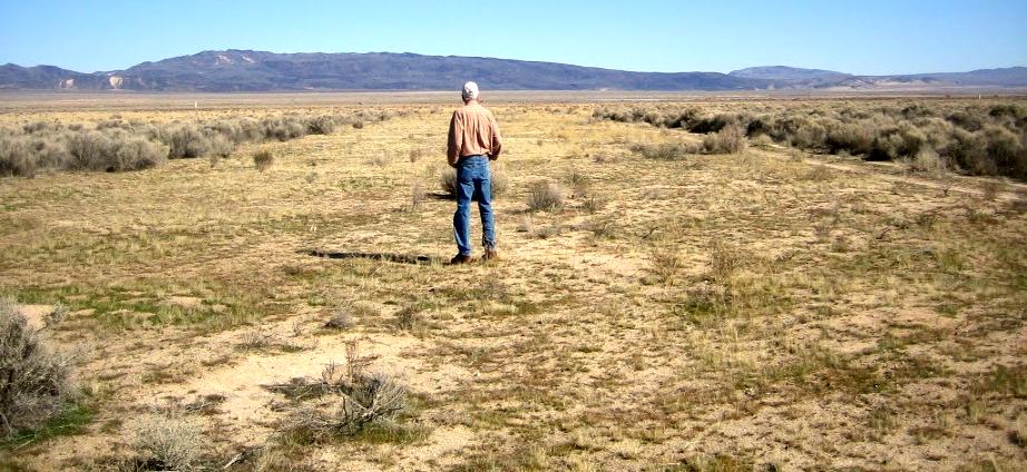
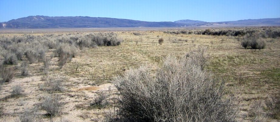
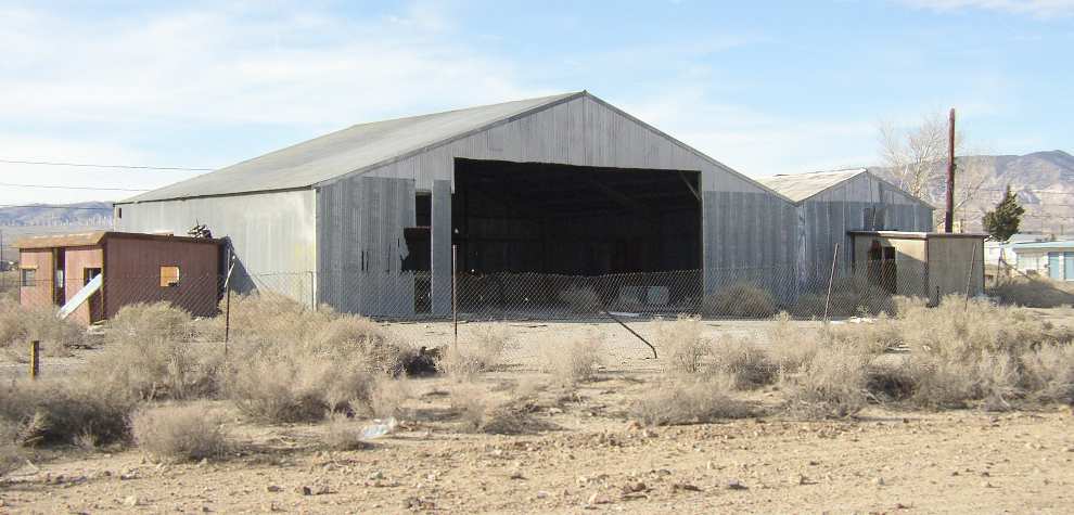
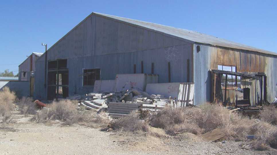
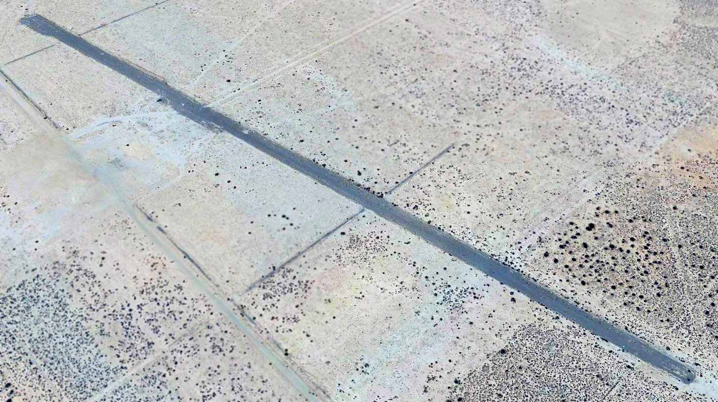
A 2021 photo looking northeast along the former US Borax Airfield runway.
Thanks to James Simms for pointing out this airfield.
____________________________________________________
Pancho Barnes Airfield, Rosamond, CA
34.865, -117.966 (West of Edwards AFB, CA)
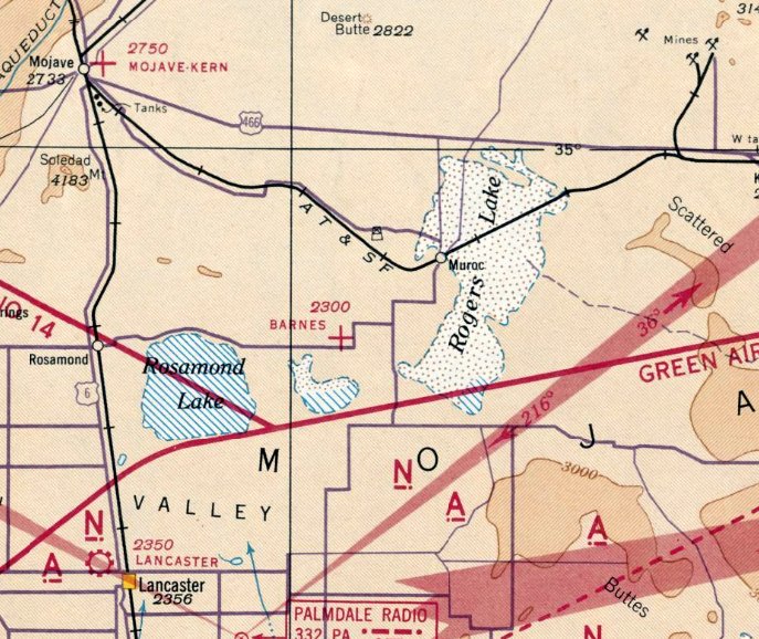
Barnes Airfield, as depicted on the October 1941 LA Sectional Chart.
If you look 4 miles southwest directly along the extended centerline of the primary runway at Edwards AFB,
you will see the remains of another historic airfield, deteriorating in the desert sun.
It was this unlucky coincidence,
being located along the centerline of what would become the world's premier flight test center
that ultimately led to this field's unhappy closure.
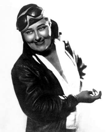
An undated portrait of Pancho Barnes.
Former Hollywood stunt pilot Pancho Barnes purchased 80 acres of desert farmland in 1935
near a small Army Air Corps gunnery range at Rogers Dry Lake.
The small gunnery range eventually became Muroc Army Airfield,
which would play a large role in the future course of Barnes' ranch.
The ranch was a working ranch at first, growing alfalfa & raising livestock.
But Pancho was never without an airplane, and one of the first things she did was to scratch out an airstrip on the desert hardpan.
Pancho set out to make the most of her new environment.
Due to the steady growth of the nearby Muroc AAF, Pancho expanded her ranch to include 2 bars, a restaurant, a dance hall,
a motel & even a swimming pool - an exotic touch for the late 1930s.
Within a few years the ranch had expanded from 80 acres to 368.
The airmen loved Pancho’s party atmosphere as the opportunities for other recreation were severely limited.
Most of the booze came up from Mexico in Pancho’s plane & was dispensed freely.
The airstrip was enlarged & illuminated for the increasing number of guests & friends who flew in.
Soon Pancho found herself the proud mistress of the "Rancho Oro Verde Fly-Inn Dude Ranch".
Among military flyers, the ranch eventually became nicknamed the "Happy Bottom Riding Club".
Barnes Airfield was not yet depicted on the November 1939 LA Sectional Chart.
The earliest chart depiction of the Barnes Airfield which has been located was on the October 1941 LA Sectional Chart.
Note that Barnes Airfeild predated the adjacent Muroc AAF (later Edwards AFB), which was not yet depicted.
Barnes Airfield was not yet depicted on the 1942 USGS topo map.
The earliest photo which has been located of Pancho Barnes Airfield was a 7/22/43 aerial view looking east
from the 1945 AAF Airfield Directory (courtesy of Scott Murdock).
It depicted the field as having 3 graded dirt runways, with a few small buildings on the northeast side.
The 1945 AAF Airfield Directory (courtesy of Scott Murdock) described Barnes Airport
as a 140 acre square-shaped property having a 3,800' northeast/southwest bare runway, with a single 80' x 50' hangar on the northeast side.
The field was said to be owned by private interests, but not in current operation.
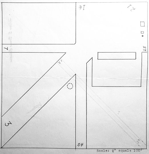
The most detailed depiction which has been located of Pancho Barnes Airfield was a circa 1940s airfield layout from a collection of papers found in a Rosamond thrift store by Mark Pasko, stamped “William Barnes Collection”.
It depicted Pancho Barnes Airfield as having 3 runways & 3 small buildings on the northeast side.
After WW2, when Muroc continued to expand in its new role
as the Air Force's primary flight test center (eventually becoming Edwards AFB), the party went on at Pancho’s place.
Pancho was a staunch friend & confidante to many of the young fliers of the day:
Al Boyd, Pete Everest, Jack Ridley & many others.
With Chuck Yeager, a bond was formed which lasted her lifetime.
When Yeager broke the "sound barrier" in the X-1 in 1947,
Pancho was one of the few who knew about the official secret.
Yeager won a free steak dinner from Pancho for that feat,
thereby starting a tradition for all pilots celebrating their first supersonic flight.
Pancho’s barroom was at the literal center of the supersonic age
and served as the unofficial debriefing room for the most elite test pilots in the world.
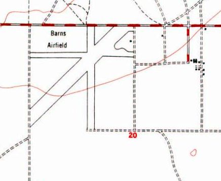
The 1947 USGS topo map misspelled the name of the field as “Barns Airfield”,
but depicted it with 3 runways with 1 small building on the northeast side.
Pancho Barnes Airfield, as depicted on the 1948 USGS topo map.
The only photo which has been located showing aircraft at Pancho Barnes Airfield was an 11/20/48 USGS aerial view.
It depicted the field as having 3 graded dirt runways, with a small hangar & another small building on the northeast side.

A closeup from the 11/20/48 USGS aerial photo of Pancho Barnes Airfield, showing 3 single-engine aircraft parked on the field.
After the first pool was destroyed in the 1952 Tehachapi earthquake, a much more elaborate pool was built to replace it,
consisting of 2 massive, inter-connected quarter sections,
customized with special options demanded by Pancho including recessed underwater lighting
and, most astonishingly, a gently sloping ramp that allowed Pancho & her horse,
after particularly arduous rides, to cool off by walking directly into the pool.
At nighttime, the shimmering, iridescent blue-green glow of the swimming pool became an unmistakable navigational beacon for fliers overhead.
In fact, it was then the only pool in the Antelope Valley.
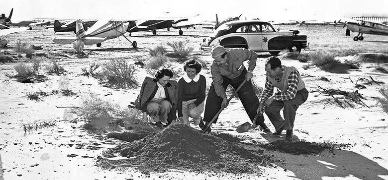
An undated photo of Pancho & Mac burrying silver dollars for a treasure hunt, with numberous light single-engine planes in the background.
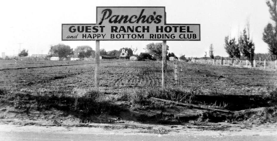
An undated photo of the sign for “Pancho's Guest Ranch Hotel & Happy Bottom Riding Club”.
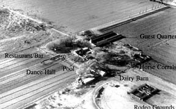
Pancho’s remote 368 acre Rancho Oro Verde property was, at the height of its fame, reachable only by air or a brutal 20-mile dirt road from Lancaster.
In spite of its isolation, the compound offered a swanky 20 room motel surrounding a remarkable 80’ fountain in the shape of the Army Air Corps insignia,
a well-stocked horse corral, a restaurant, airplane hangars, 3 landing strips, a dance hall, gambling den,
and the world-famous bar where she hosted what she called "the fastest & bravest men on earth."
Bordered by lush planting of cottonwoods, Chinese elms, poplars & bamboo,
the Happy Bottom Flying Club was a verdant oasis in the desert & the site of a lifestyle as exuberant as its host.
Yeager’s boss in the flight test world, Col Albert Boyd, was another legendary old-time pilot who had warm regard for Pancho & her accomplishments.
But after his departure from Edwards in 1952, the good times rapidly drew to a close.
Soon after the next commander arrived on the scene, the entire atmosphere began to change.
The reasons were many: conflicting requirements, personality clashes, and some genuine misunderstandings.
The immediate catalyst was airspace, which was becoming increasingly crowded with large numbers of new aircraft being tested,
and the private airplanes of Pancho’s guests.
The borders of the base were already pressing hard upon Oro Verde,
and a master plan had already been written calling for it to expand to its present western boundary.
There was even talk of lengthening the Edwards runway to a total of 27 miles (!),
to accommodate the atomic-powered aircraft then on the drawing board (see Test Area North, ID).
Given that it was located only 4 miles away from the end of Edwards' Runway 4,
directly along the extended centerline, the Happy Bottom Riding Club was doomed.
It was not long before condemnation proceedings were filed against Pancho’s property,
on the grounds that the ranch lay on a direct line with a proposed extension of the test center’s main runway.
But the situation was greatly worsened by a complete lack of rapport between the principals,
and conflicts soon escalated into name calling, unjust accusations, and ultimately into a flurry of acrimonious lawsuits.
In the middle of the fray, in 1953, coming at the worst possible time, a "mysterious" nighttime fire burned down the main buildings of the ranch,
taking its memories of Hollywood celebrities with it.
The September 1954 LA Sectional Chart continued to depict Barnes Airport, and described the field as having a 3,600' unpaved runway.
Later in 1954, as part of the expansion of the base boundaries, Barnes' former ranch became part of the Edwards AFB property.
Barnes Airport was no longer depicted at all on the March 1955 LA Sectional Chart.
A 1959 aerial view showed Barnes Airport to consist of 3 dirt runways.
Barnes Airport was no longer depicted on the 1969 USGS topo map.
According to Patrick Ryan, “When Pancho died [1975] her son was allowed to fly over her old ranch at Edwards AFB to spread her ashes.”
According to Dan MacPherson, Pancho's hangar was purchased by Gus Briglieb & moved to El Mirage airport, where it still exists.
No traces of the former Barnes Airport were depicted on the 1982 or 1994 USGS topo maps.
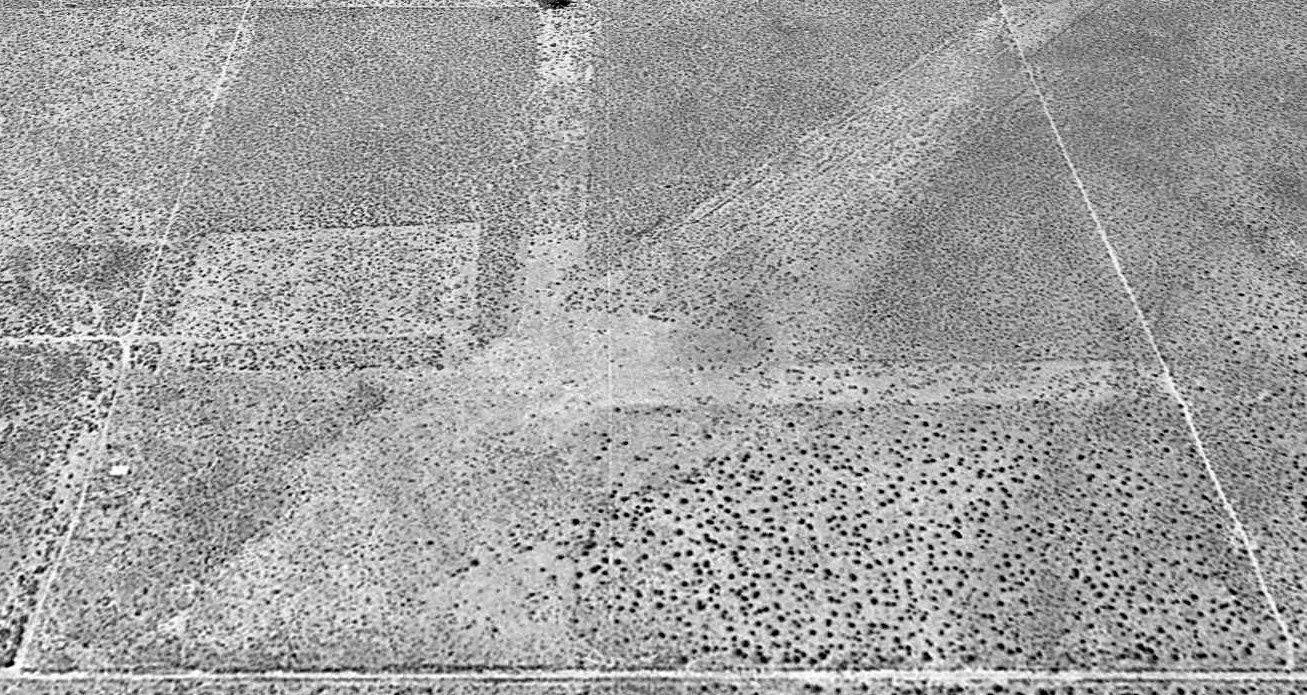
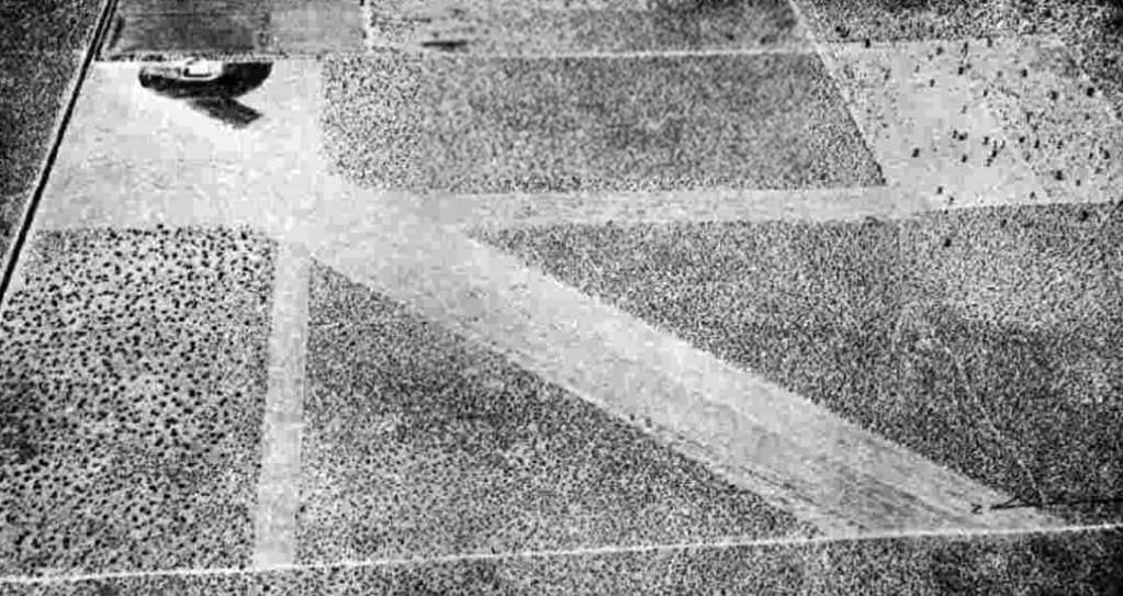
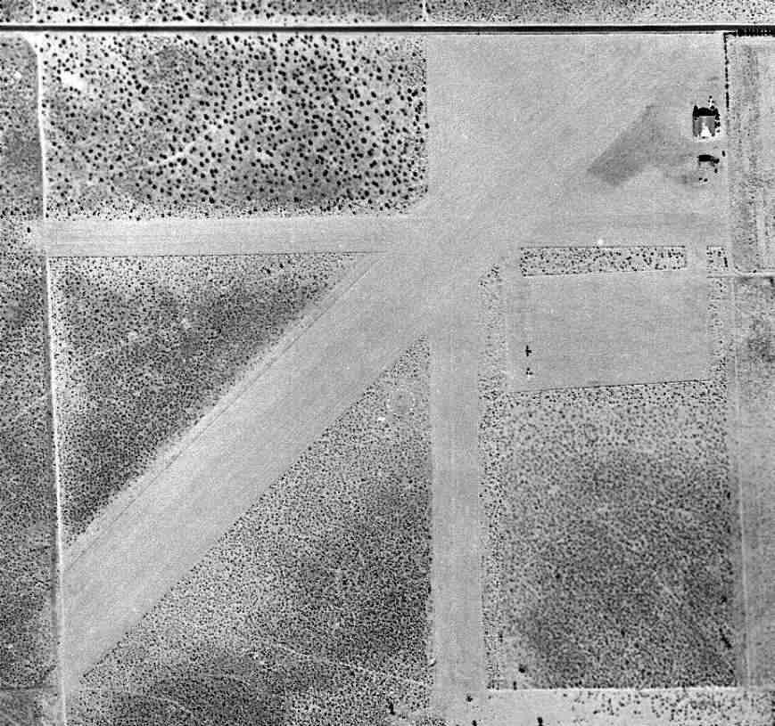
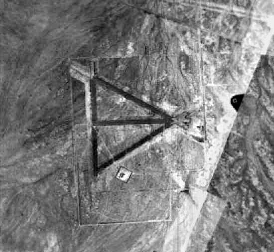
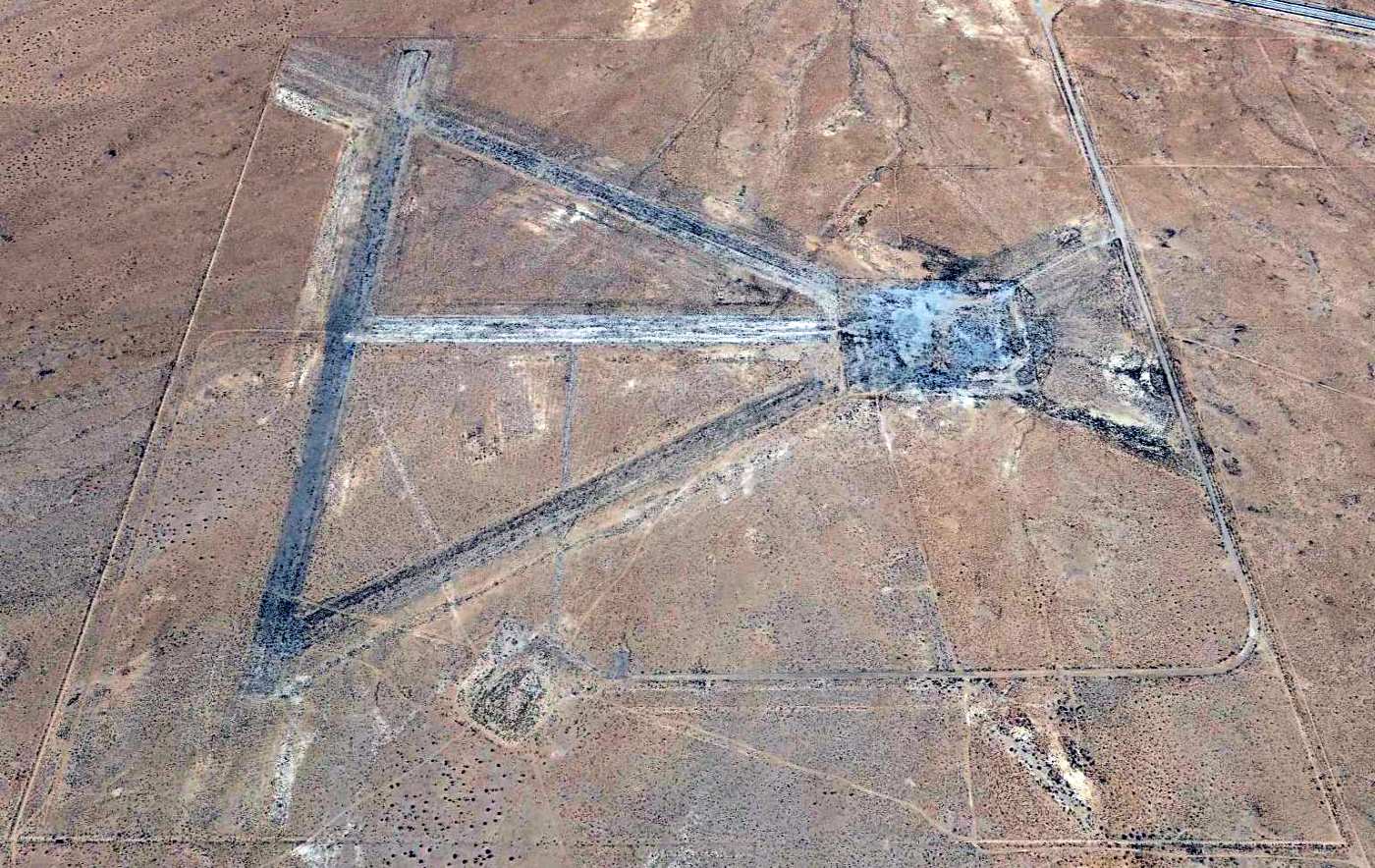
A 1994 USGS aerial view looking south showed the recognizable remains of 3 runways at the site of the Pancho Barnes Airfield, along with building foundations on the northeast corner (lower-left).
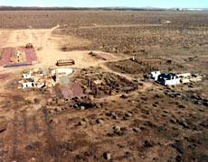
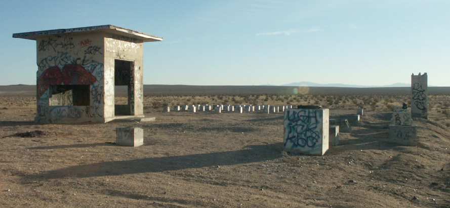
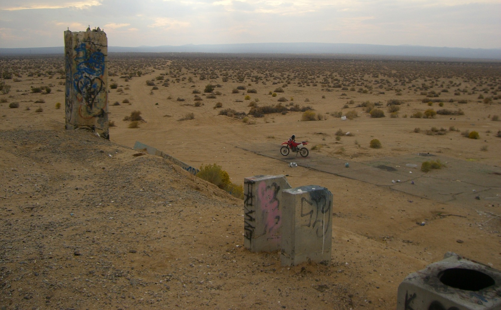
A circa 1990s photo of the remains of the "Happy Bottom Riding Club".
A circa 1990s photo of the remains of the Happy Bottom Riding Club, showing the extent of the fire that ravaged the buildings.
An aerial view by Richard Menzies of the remains at the "Happy Bottom Riding Club".
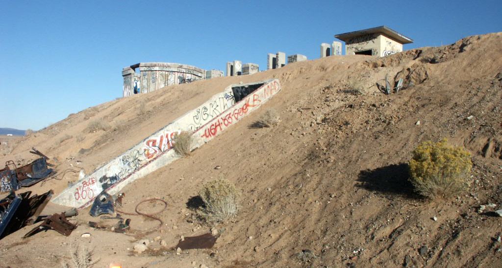
A circa 2003 photo of the remains of the swimming pool,
Today, the remains of her ranch are now part of the base’s small arms firing range.
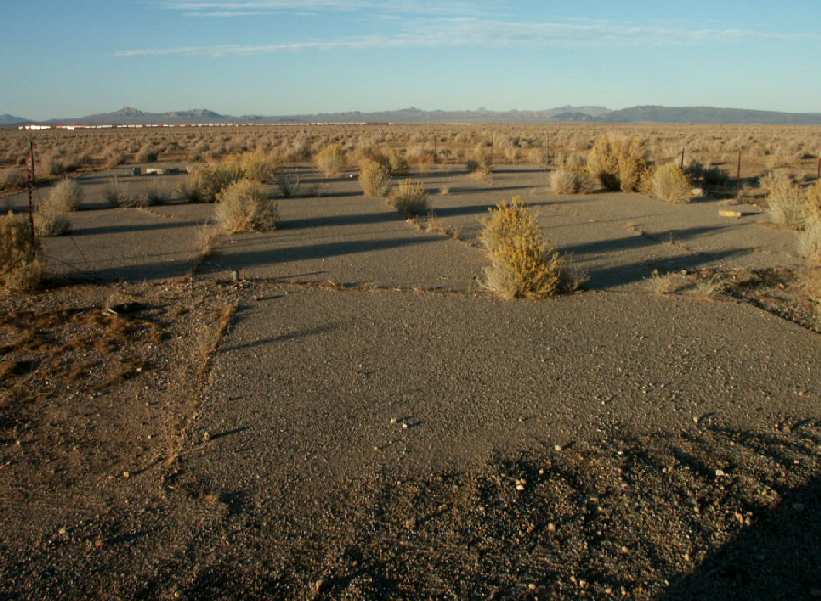
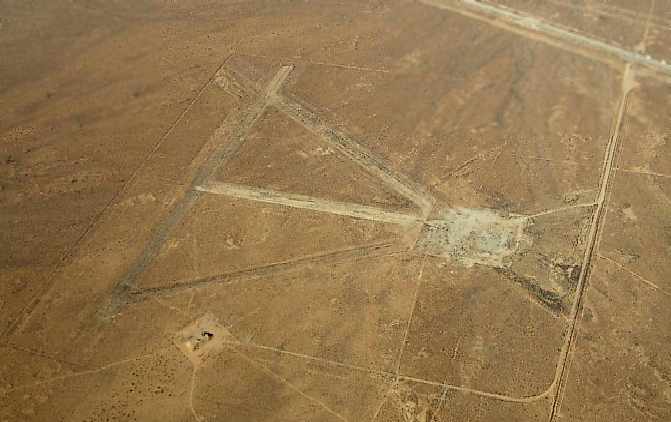
The outline of the former airfield is still perceptible in aerial photos of the site,
with 3 runways: north/south, east/west, and the primary runway, which runs northeast/southwest & is 5,500' long.
East of the airfield are the remains of the ranch.
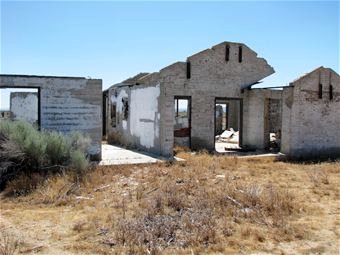
Although the main building of the Happy Bottom Riding Club was lost in the fire, other things remain.
The remarkable 4-tiered cascading fountain that graced the motel esplanade still stands, as well as the double-sided fireplace from the dining room.
On the east side of the ranch is the infamous wooden gate which Yeager struck on horseback (breaking 2 ribs),
the night before he became the first man to break the sound barrier.
Even the swimming pool remains largely intact.
North of what were the main buildings are the remains of a Ryan PT-19 aircraft
which was ‘borrowed’ by 2 young locals from Pancho’s personal fleet of airplanes & crashed short of the main runway.
According to the Edwards AFB web site, "visiting is prohibited for safety reasons".
In memory of the old days, however, Air Force Flight Test Center personnel hold an annual barbecue on the old foundations of the club.
And in a hangar in nearby Mojave, Pancho’s black & red Travel-Aire Mystery Ship is being restored to its original splendor.
Gail Lofdahl recalled, “I worked at many of the AF Flight Test Center Historical Foundation's Pancho Barnes BBQs (which ceased after 9/11 made base access difficult).
The site offers some beautiful sunsets & interesting foundations, but has a lot of hazards
(I literally stumbled across an uncapped water well one night while taking a shortcut from the parking lot to the cook tent).”
Good news for the Pancho Barnes site came in 2014, when an Edwards AFB article (courtesy of Leigh Kelly)
reported how her Rancho Oro Verde site had been recommended as eligible for listing on the National Register of Historic Places,
and the 412th Test Wing Civil Engineering would work to preserve the site.
A 2022 aerial view looking south showed the recognizable remains of 3 runways at the site of the Pancho Barnes Airfield, along with building foundations on the northeast corner (lower-left).
The site of Barnes Airfield is located west of the intersection of Willow Springs Road & Barnes Road.
----------------------------------------
Note: The buildings of the former Barnes Motel were relocated at some point from her ranch
to 14301 Frontage Road, which is across the highway from the north base entrance to Edwards AFB.
Dan MacPherson photographed the buildings in 1998, which were being used as the Desert Sage Apartments.
See also:
http://www.edwards.af.mil/history/docs_html/people/pancho_barnes_biography.html
http://www.edwards.af.mil/articles98/docs_html/splash/jun98/cover/pancho.htm
http://www.clui.org/clui_4_1/lotl/00f/00f3a.html
____________________________________________________
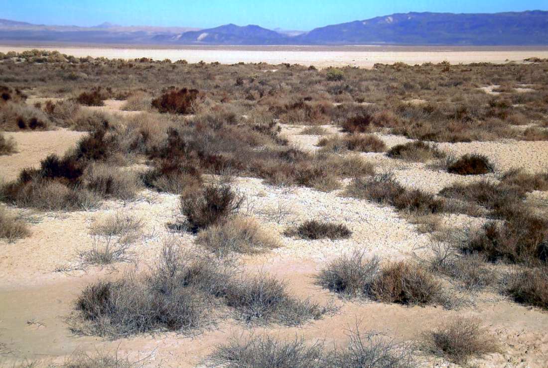
Gypsy Springs Airfield, Gypsite, CA
35.335, -117.93 (North of Edwards AFB, CA)
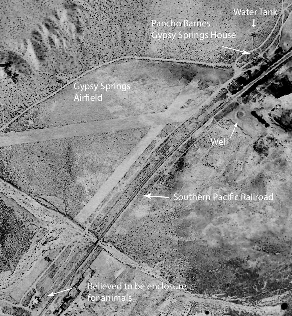
Gypsy Springs Airfield, as depicted on a 1965 aerial view (courtesy of Dan MacPherson, annotated by Steve & Patrice Demory).
This was the second airfield established by former Hollywood stunt pilot Pancho Barnes.
According to Dan MacPherson, “Pancho & Mac moved to Gypsy Springs (Gypsite) which is on the northeast boundary of Edwards AFB in 1956
and the airport opened in January of 1960 as Pancho tried to rekindle the Happy Bottom Riding Club.”
Nothing was depicted at the location of Gypsy Springs Airfield on the 1961/65/67 LA Sectional Charts.
The earliest photo which has been located of the Gypsy Springs Airfield was a 1965 aerial view (courtesy of Dan MacPherson, annotated by Steve & Patrice Demory).
It depicted Gypsy Springs Airfield as having 2 unpaved runways, with a few small buildings on the south side.
Dan MacPherson observed, it “looks almost new in 1965.
It is between the narrow gauge tracks & Redrock Randsberg Road, on a line true north from California City Airport.”
Nothing was depicted at the location of Gypsy Springs Airfield on the 1967 USGS topo map.
According to Dan MacPherson, “Unfortunately things failed to coalesce like they did at the previous location.
Mac left, Pancho spent her inheritance & moved to a tiny rock house in Boron, where she died alone.”
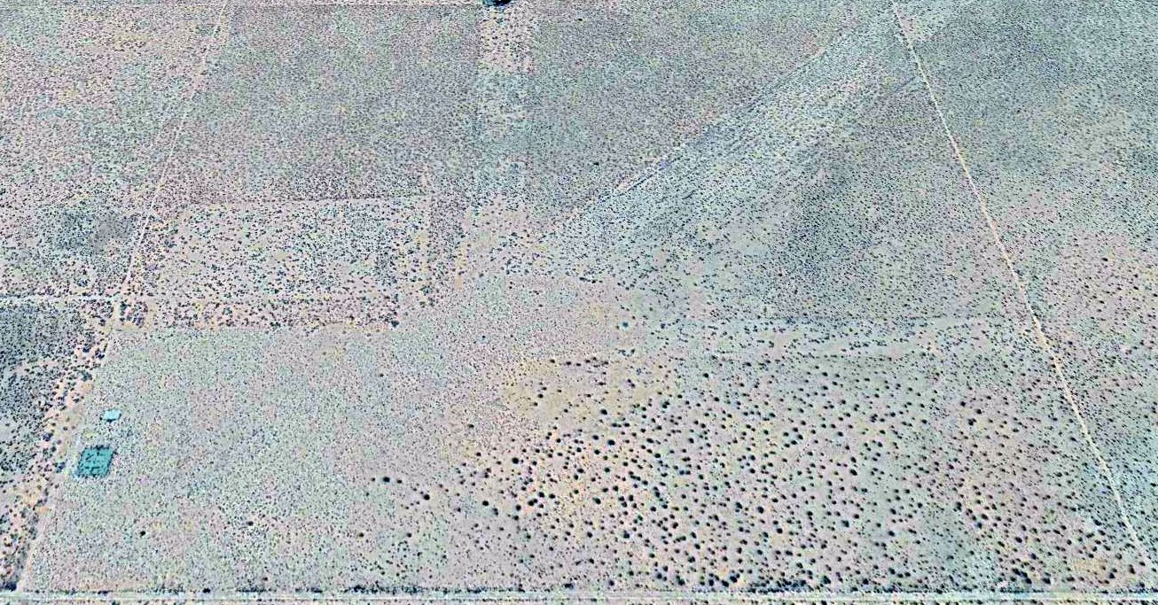
A 2015 aerial view showed faint traces were still recognizable of 2 runways at the site of the Gypsy Springs Airfield.
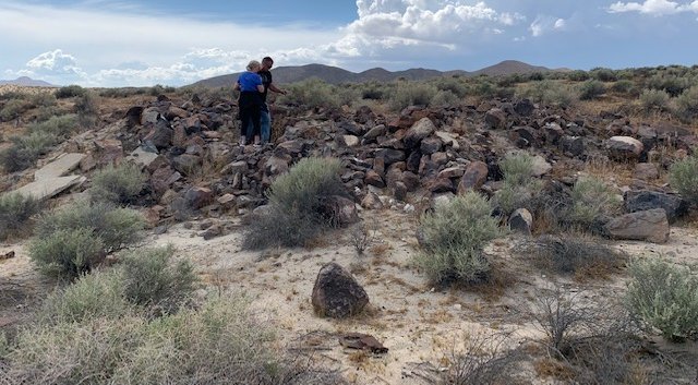
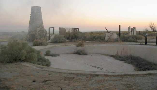
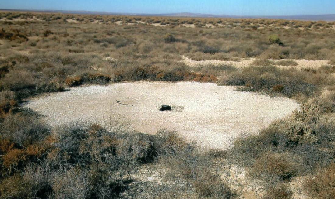
A 5/25/19 photo by Katy Hutchinson of the remains of a building at Gypsy Springs, possibly Pancho Barnes' house.
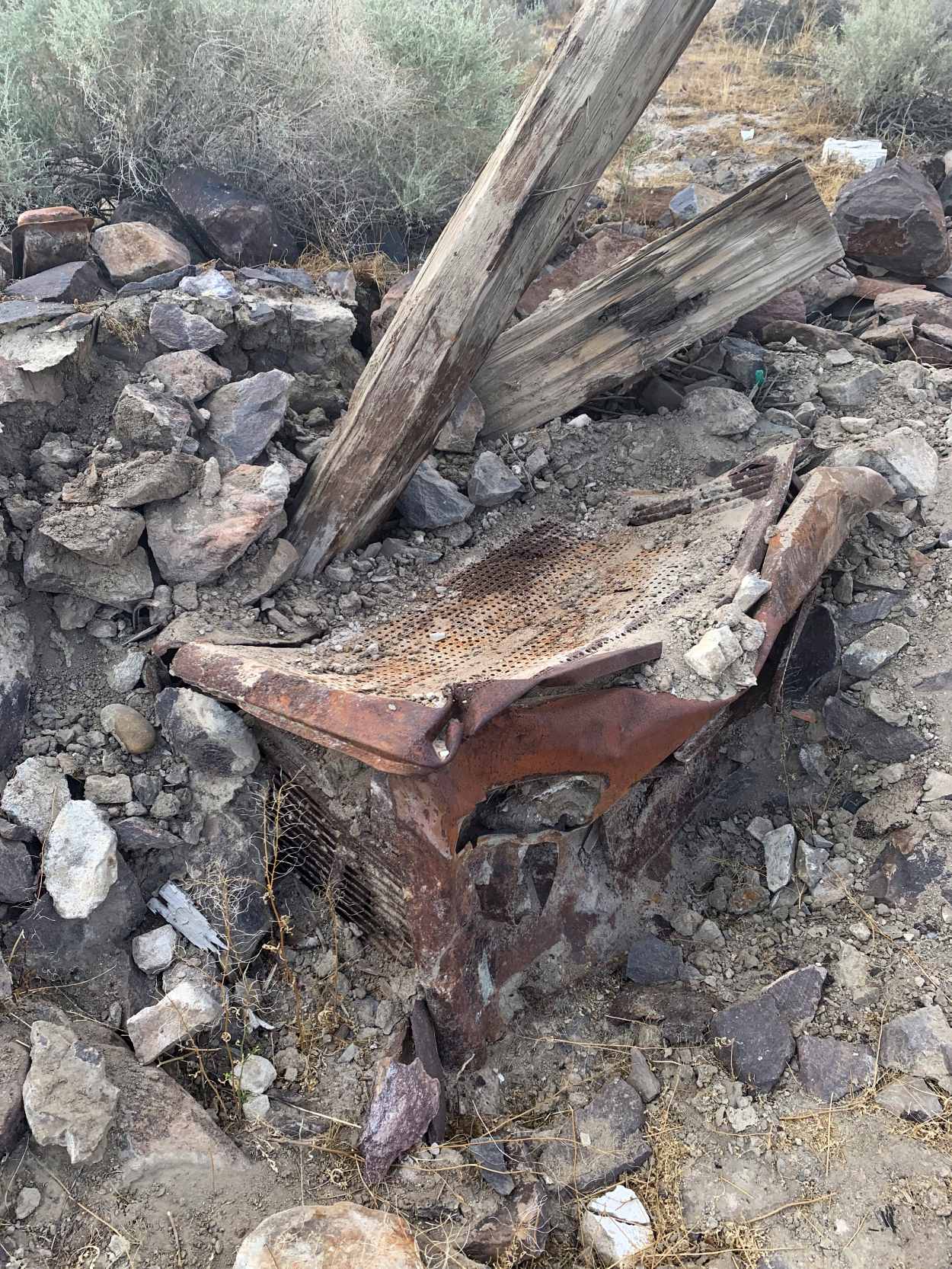
A 5/25/19 photo by Katy Hutchinson of “what appeared to be an old stove, surrounded by rocks and stucco & wire” at Gypsy Springs.
The site of Gypsy Springs Airfield is located northeast of the intersection of Cantil Road & Redrock Randsburg Road.
Thanks to Dan MacPherson for pointing out this airfield.
____________________________________________________
Hawes Aux Army Airfield #1, West of Barstow, CA
34.923, -117.375 (Northeast of Los Angeles, CA)
A 6/4/42 AAF aerial view looking south at Victorville Aux AAF #1 (from the National Archives, courtesy of Brian Rehwinkel).
This airfield was built during WW2 as one of 4 satellite fields for Victorville AAF (later renamed George AFB),
which participated in the 30,000 Pilot Training Program & later became a bombardier school.
Hawes was evidently established at some point between 1940-42,
as it was not yet depicted on the 1940 USGS topo map.
The earliest depiction which has been located of the field
was a 6/4/42 AAF aerial view looking south at Victorville Aux AAF #1 (from the National Archives, courtesy of Brian Rehwinkel).
It depicted the field in its original configuration, with 4 paved runways.
A 4/20/43 AAF aerial view of Victorville Aux AAF #1 (from the National Archives, courtesy of Brian Rehwinkel)
showed construction underway to extend 3 of the runways.
A close inspection will reveal paving trucks & equipment on the north end of the runways.
Hawes Aux AAF was not yet depicted on the February 1944 LA Sectional Chart.
The 1944 US Army/Navy Directory of Airfields (courtesy of Ken Mercer) described "Hawes Aux. #1, Army" as having a 5,600' hard-surface runway,
and the remarks included, "Auxiliary to Victorville AAF."
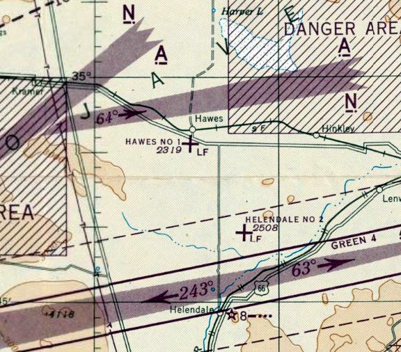
The earliest aeronautical chart depiction which has been located of the Hawes Aux AAF was on the March 1945 LA Sectional Chart,
which depicted depicted Hawes #1 as an auxiliary airfield.
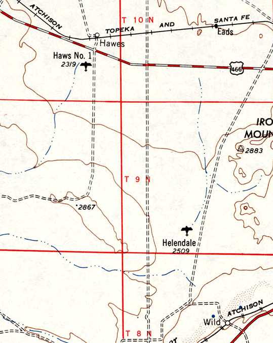
“Haws #1” [sic], as depicted on the 1948 USGS topo map.
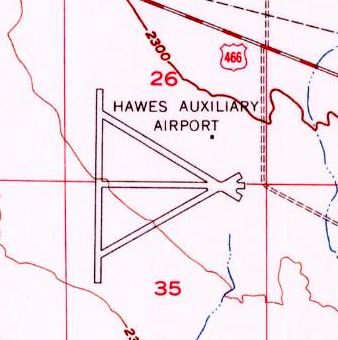
The 1956 USGS topo map depicted Hawes Auxiliary Airport as having 4 paved runways.
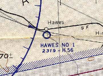
"Hawes #1" was still depicted as an active military airfield on the 1960 LA Sectional Chart (courtesy of Chris Kennedy).
It was described as having a 5,600' hard-surface runway.
The Hawes airfield was evidently closed at some point between 1960-64,
as it was not depicted at all on the 1964 LA Sectional Chart (courtesy of John Voss).
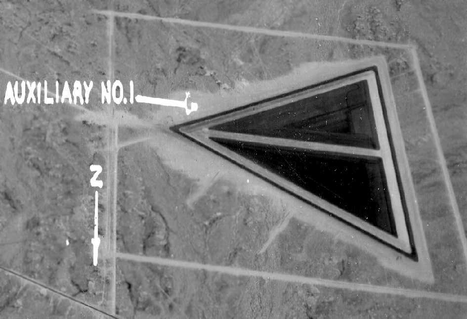
A 1964 aerial view (courtesy of Bob Anderson) depicted the Hawes airfield as having 4 paved runways laid out in a triangular configuration.
The radio site had not yet been built adjacent to the airfield.
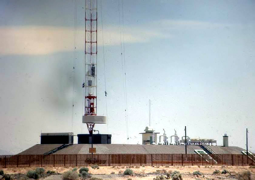
At some point between 1964-67, a large Air Force radio relay station was built adjacent to the south side of the Hawes airfield,
named the "USAF Survivable Low Frequency Communications System Site, Hawes" (according to Tim Tyler).
On the 1967 LA Sectional Chart (courtesy of Chris Kennedy), the Hawes site was marked with an obstruction symbol (approximately 1,000' above ground level),
due to the massive radio tower which occupied the site.
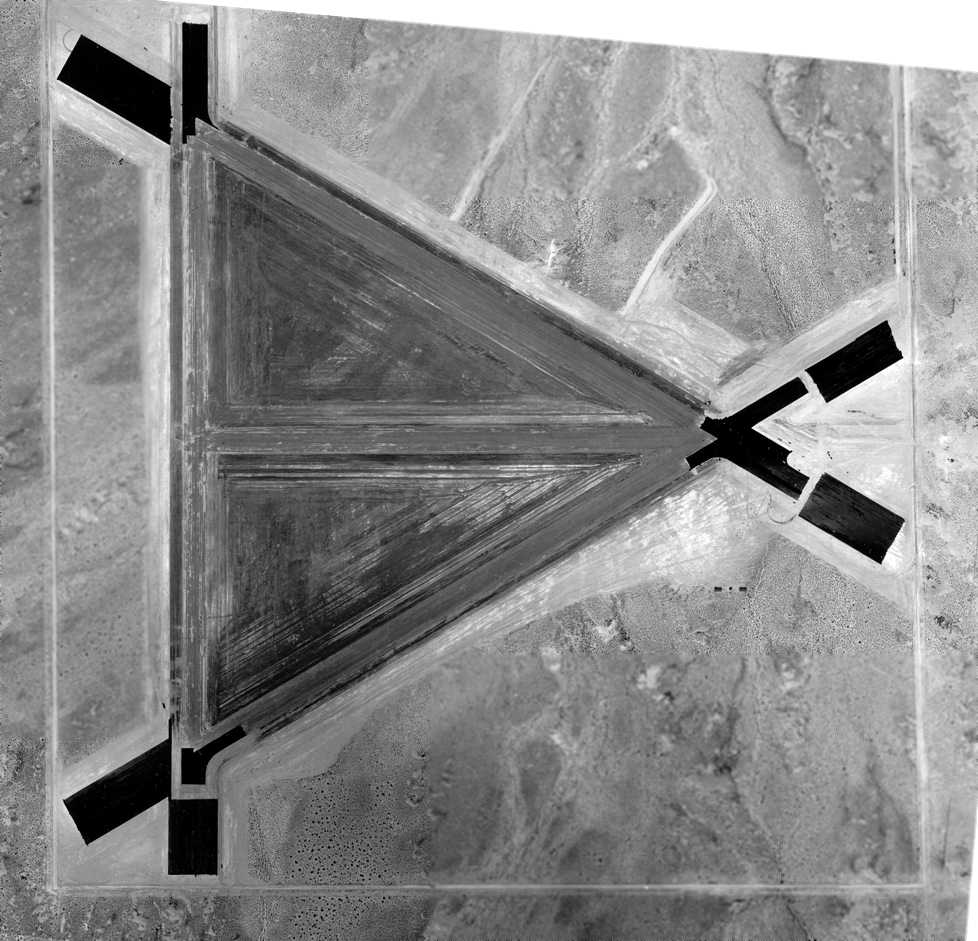
A 1968 aerial view of the former Hawes airfield (courtesy of Bob Anderson).
clearly depicted the new perimeter fence which had been constructed to enclose the new Air Force communications site,
as well as the antenna blockhouse just south of the runways.
The runway pavement appeared to remain intact.
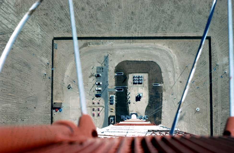
An amazing picture from a unique perspective: a 1968-70 photo by Lyle Abel looking 1,000' straight down from the top of the Hawes radio tower.
Lyle observed of the picture, “The radials that you see in the desert are copper cables buried in the desert to form a counterpoise (a good ground reference for the RF transmitter).
They originate at the base of the tower & are separated by a degree, roughly, to an engineered point in the desert.”
Lyle Abel recalled, “I was stationed at the Hawes T/R site from 1968-71... I was one of the shift supervisors there.
We lived on Edwards AFB & would drive to the site for a 24 hour shift.
This was truly state-of-the-art equipment. When I arrived I didn't recognize any of it as high power radio equipment.
It looked like banks of computers to me. After I became familiar with the equipment I learned to really respect & appreciate it, I thoroughly enjoyed working with it.
On one occasion, someone peeked into the 'helix' room & noticed that it was flooded with water... a little scary, since there was 110 KW of RF energy floating around in there.
The contractor had failed to cap one of the pipes going from that room to the outside area. There had been flooding in the area & it ran into the room.
We got permission to shut down the transmitter & it took us most of the day to get rid of the water.
The barbwire fence was broken up in short lengths...not because it would affect the LF/VLF system, but because it would knock you on your butt it you touched it.
The short lengths could not build up a high voltage from the LF/VLF transmitter RF cutting through the wire 24 hours per day.
I can attest to that, because I was dumb enough to grab a loose length of wire on a light pole in an attempt to get rid of it... big shock!
When I arrived people were outside during shift changes, lunch, volleyball games & BBQs on weekends with the transmitter at full power.
We were all told that at that frequency 20-60 khz there was no danger.
After being there for 2 years HQ AF came out with an order that the site would be shut down for shift change
and people should not be outside while the transmitter was at full power... SCARY!
The transmitter was built by Westinghouse & it had refrigerated air pumped directly into the transmitter in 2 places... not just into an air conditioned room.”
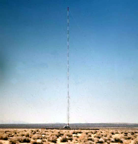
A circa 1970 photo by Mel Carreira of the Hawes radio tower.
Mel Carreira recalled, “I was stationed there for about a year, around 1970.
It was an amazing system. It was a totally solid-state transmitter.
There was an identical transmitter site in Nebraska & a transmitter located on the flying command post Looking Glass.
The sysem was a backup for launching the ICBMs that were controlled by Strategic Air Command.
It could transmit data at 5 & 10 characters / second.”
Mel Carreira continued, “The tower was a little over 1,200 feet. It was about the same height as the Empire State Building.
We used to go up the antenna via an internal elevator. We used a cherry picker to get to the bottom of the elevator.
And I remember the Westinghouse engineer warning us to hop off the cherry picker cage & jump on to the antenna base.
It was very interesting place to work. Everything was digital, which was amazing for the 1970s. I am still impressed with the technology.”
Mel Carreira continued, “My best story is... I was on duty in the secure double steel door transmitter room, when all the alarms on the 487 L system went off.
We started to receive an unscheduled message from the site in Nebraska. We thought it was WWIII.
Well, the message said '"We have been trying to contact the site for several hours via telephone & land-line teletype from March AFB.
They knew the site was OK because we were outputting our idle signal.
That signal was monitored by receivers all over the world.
Well it turns out the telephone company routed the telephone & teletype lines via a microwave system that had failed.
We sent back a response to March AFB, via the HF radio.
After that, we had to contact March via teletype every hour.”
A circa 1970 photo by Mel Carreira of the base of the Hawes radio tower.
Jim Brough recalled, “I was stationed at Hawes from 1983-85.
I was a ground radio communications repairman at that time,
so I worked on the actual transmitter and receivers, as well as doing minor service work on the antenna.
One of the fun things was changing the aircraft hazard warning lights on the tower, as that meant an elevator ride, and a breathtaking view.
The runway was still in existence during the early 1980s.
It was broken & covered with weeds, but clearly had not been (completely) removed.”
According to Mark Raymond (TSGT, USAF, retired), for years the radio tower remained a prominent landmark on Route 58 west of Barstow.
According to Mark Raymond, "I can offer a guess as to why the runways were removed.
If the runways were steel-reinforced they would have disrupted the transmission pattern of the antenna tower.
When the facility was open it had a wood fence instead of chain link or barbed wire.
There was an 'outer perimeter' fence that was made of 3 strands of barbed wire
but it had insulators in the strands so it would not form a complete ring around the facility.
Low Frequency communications are strange that way."
The radio relay site was closed in the mid-1980s.
Mel Carreira recalled, “It is too bad they didn't preserve the site & use the antenna for peaceful purposes.”
The Hawes runway pavement appeared to have been removed by the time of a 1994 USGS aerial view looking north.
The remains of the radio site were visible on the southern portion of the airfield.
A 2002 photo by Jon Vanover of the base of the former radio tower at Hawes.
The structures on the top of the building are (from right to left):
the "cherry picker" enclosure, the wall surrounding the base of the former tower, and the "dummy load" enclosure.
One of the concrete anchors for the former tower is in the foreground at right.
A 2003 photo by Tim Tyler of the road which leads to the former SLFCS radio facility at Hawes.
Tim reported, “The site is accessed off of Highway 58.
The first 100’ or so of the access road is 2 lanes & nicely paved, but then from that point on, it’s a dirt road."
A 2003 photo by Tim Tyler of the remains of a shack at Hawes.
A 2003 photo by Tim Tyler of the base of the former SLFCS radio facility at Hawes.
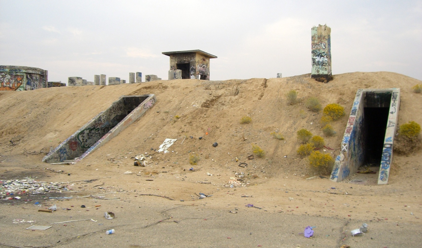
Tim Tyler reported in 2003, "The earth-covered blockhouse building is intact, with all internal & exterior doors open (or missing).
One of the 3 diesel engines is still in the power plant room, yet somehow,
someone within the past year or so has been able to lift off the top half (which must weigh at least 2,000 pounds)
and set it down on the ground, apparently to gain access to the cam shaft or other internal pieces.
Most of the rooms in the earth-covered bunker are covered with graffiti, and have been subjected to fires.
No obvious signs of what the rooms were used for, other than the generator room,
decontamination chamber, helix room at the base of the antenna area, latrine, and what seems to have been a kitchen area.
Much of the large ventilation ducting is still in place on the ceilings,
some electrical panel boxes and metal conduit are intact, but with the wiring removed."
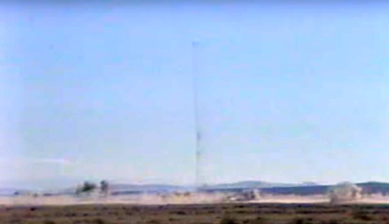
Tim continued, "There are some major hazards at the site - holes on the roof from debris falling when the tower was dynamited
and penetrating through the approximately 1 foot of soil & then 1 foot of steel reinforced concrete ceiling.
I’ve been wanting to see this site for over a decade now, but shame on our government for creating this attractive nuisance.
The tower guy wire cement anchors are still out in the field surrounding the site,
and there are small lengths of guy wire remains around the blockhouse."
A 2003 photo by Tim Tyler of the remains of pavement at Hawes.
Could this be a remnant of the former airfield, or the Hawes Radio facility?
Tim Tyler observed, "The grounds are a former WW2 era Hawes Auxiliary Airfield #1, but I saw no traces of this mission on the grounds
while heading to/from the Survivable Low Frequency Communications System site, nor while standing on the top of the SLFCS blockhouse.
I understand that for some reason, the runways were removed, even though the field is out in the middle of nowhere.
It was probably done during the SLFCS days,
to prevent curious pilots from flying in the vicinity of the 1,200’ tower and guy wires to ‘inspect’ the former airfield."
Tim continued, “Hawes is pretty much a non-existent community, though I did pass a Hawes Creek while on Highway 58,
about a mile or 2 away from the turnoff into the SLFCS site.
I understand that the Army Corps of Engineers is now in the final stages
of contracting for the demolition of the site & the sister facility in Silver Creek, Nebraska.”
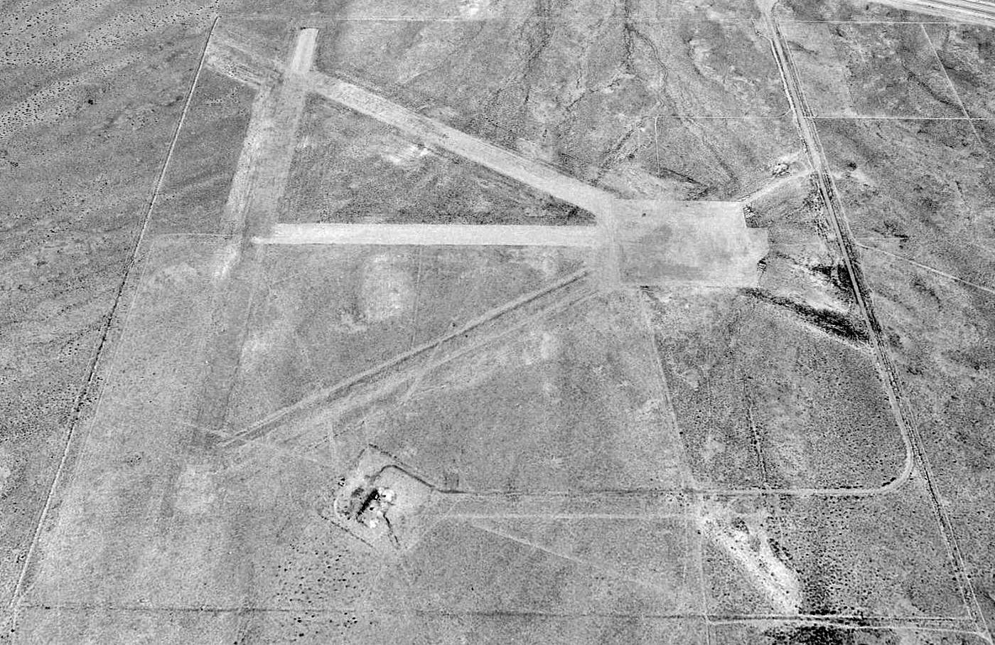
A January 2007 aerial view by Vince Osburn, looking northwest at the Hawes runways.
The remains of the radio site were visible on the southern portion of the airfield.
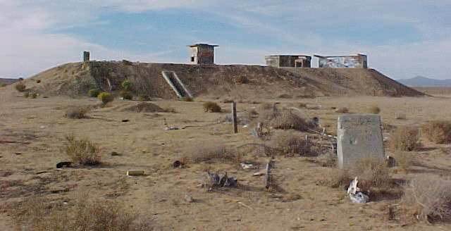
A 10/27/07 photo by Rick Hull looking out from the top of the former Hawes radio bunker.
A 10/27/07 photo by Rick Hull of the former radio bunker at Hawes.
Rick observed, “It took a lot of work to demolish the place, it was built solid.”
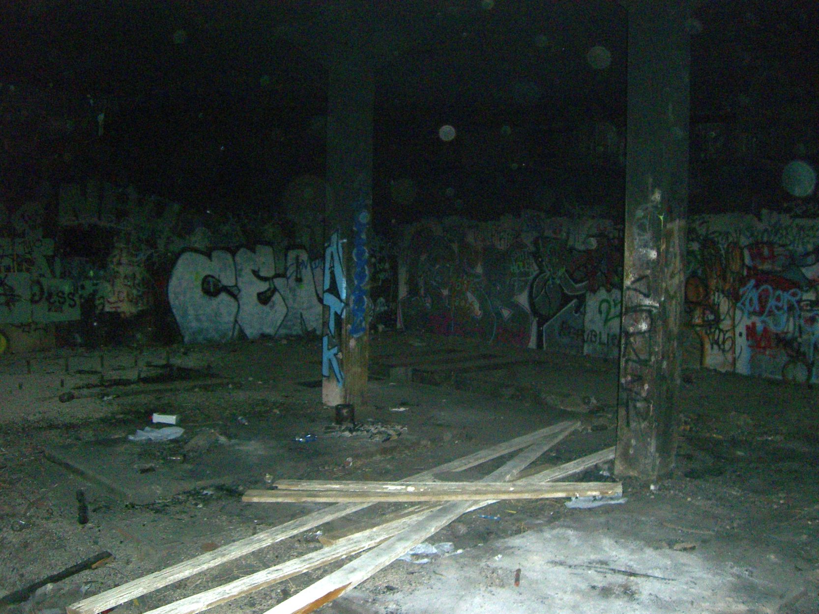
A 10/27/07 photo by Rick Hull of the interior of the former radio bunker at Hawes.
Greg Loskorn reported, “I went out to the Hawes site to get some more pictures (1/23/10)
and the bunker has been completely removed & the ground smoothed over. Google Earth's recent photos confirm this.
The large concrete guy wire anchors are still scattered throughout the surrounding area though.
Too bad, I wanted to get some more pictures with a better quality camera before it was demolished.”
Lyle Abel recalled in 2011, “I returned a few years ago & was sad to see the tower laying around on the ground in pieces.”
A 2015 aerial view looking north at the remains of the Hawes runways & its radio tower site.
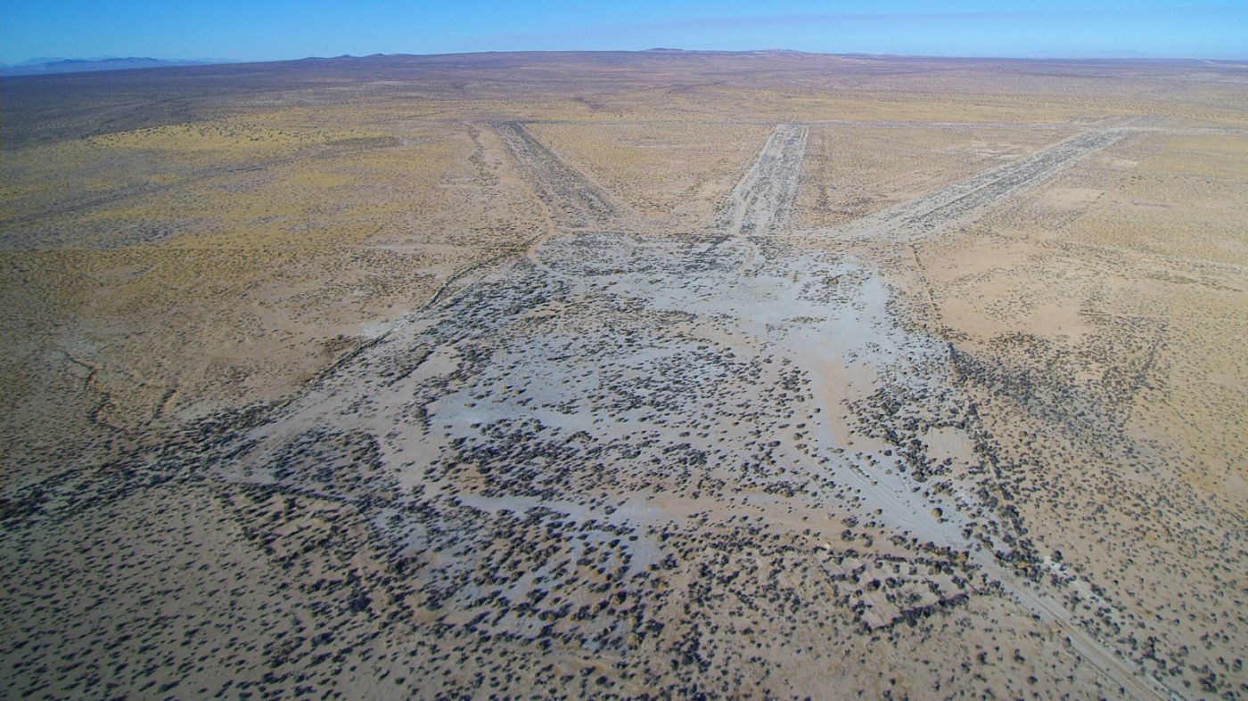
An amazing 11/13/16 aerial view by John Pflughoft looking west at the remains of the Hawes Auxiliary Airfield, taken from his Yuneec Q500 4k drone.
Thanks to Walt Witherspoon & Paul Hirose for information about Hawes.
____________________________________________________
Harper Dry Lake Airfield, Lockhart, CA
35.042, -117.336 (Northeast of Edwards AFB, CA)
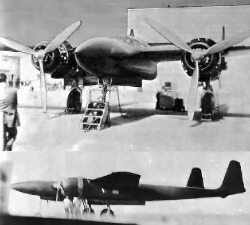
A pair of (heavily retouched) circa 1943-44 photos of the Hughes D-2, with the air conditioned Harper Lake hangar in the background.
The man in the suit at left may be Howard Hughes.
This dry lakebed in the Mojave Desert was the site of secret flight test programs
conducted by the Hughes & Northrop aircraft companies during the 1940s,
including the historic first flight by an American rocket-propelled aircraft.
When Howard Hughes' secret D-2 prototype was ready for final assembly in May 1943,
it was relocated from Hughes' Culver City facility to Harper Lake,
where a hangar & other installations had been constructed to conduct a flight test program in secret.
In characteristic fashion, Howard Hughes himself began the D-2's flight test program on 6/20/43.
However, after only a few brief hops, it was clear that high control forces were a problem,
and modifications commenced to the planes wing, ailerons, and flaps.
When Hughes flew the D-2 again on 8/2/43, the modifications proved insufficient to correct the control issues.
The wooden airplane remained in its air conditioned, humidity controlled wooden hangar
until it was destroyed on 11/11/44 by a fire that was said to have been sparked by a lightning strike.
However, it has been reported that the fire was not accidental,
and it has also been reported that Hughes tried to intentionally damage the troublesome D-2 during earlier taxi tests
so that he could start over with a fresh design.
Hughes reportedly made sure that all evidence of the D-2 project disappeared from the site
including ashes, charred pieces of wood & metal, foundations, utility lines & other structures –
all hauled to a secret burial site somewhere out on the desert.
Hughes eventually went on to develop a larger, higher-performance evolution of the D-2, known as the D-5.
Under the military designation of XF-11,
it would eventually be built & flown from the Hughes Culver City facility.
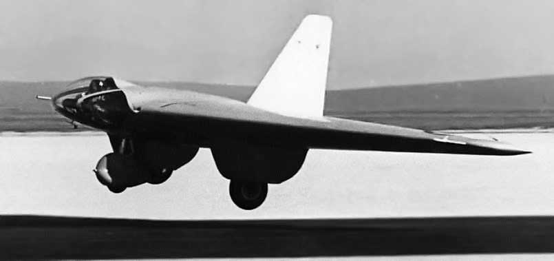
A circa late 1940s photo of the Northrop MX-324 in flight, possibly taken at Harper Dry Lake.
Another chapter in the history of Harper Dry Lake involved the diminutive Northrop MX-334 flying wing.
The MX-324 had first been flown as a glider at nearby Muroc Army Airfield in late 1943 & early 1944.
At which point Northrop technicians installed a 427-pound Aerojet rocket motor in the squat, tailless aircraft.
The motor nozzle, protruding through the trailing edge of the thin wing,
was the only outward evidence of the engine's presence,
although the actual motor, 4 pressure tanks, 2 propellant tanks, and hydraulic & electric control equipment were carefully fitted into the wing.
One of the considerations in the design of this airplane was protection of the pilot
from the mono-ethylaniline fuel & red fuming nitric acid oxidizer.
The fuel tank was installed on one side of the pilot & the oxidizer tank on the other side.
A heavy neoprene curtain was installed on each side of the pilot to protect him from any rupture of tanks or lines.
Beginning on 6/20/44, exhaustive ground tests of the rocket motor were conducted at Harper Dry Lake,
culminating in taxi tests on the desert floor by Harry Crosby.
By the evening of July 4, the craft & Crosby were ready for their momentous flight.
Finally, almost 3 years after the successful maiden flight of the German Me 163,
Harry Crosby eased himself into the prone position in the cramped cockpit of the MX-324.
With his head resting in a special sling behind the large glass windshield,
Crosby had a clear view of the long tow line & the P-38 Lightning that was to tow him up to release altitude off the cracked, dry surface of Harper Dry Lake.
Early in the morning of 7/5/44, P-38 pilot Martin Smith' towed Crosby & his strange-looking craft over the dry lake at about 8,000'.
Crosby tripped the towline release, braced himself in the narrow confines of the cockpit,
and pressed the propulsion trigger on the control stick.
Ignition of the 200-pound thrust Aerojet XCAL-200 rocket motor produced remarkable acceleration.
America's belated entry into the era of rocket-powered flight had been made.
A short flight of over 4 minutes ended with a gentle landing on the dry lake bed.
Following Crosby's July 5th flight, other powered flights of the Rocket Wing were conducted.
Some of these featured the early use of telemetry to transmit flight test data by radio to ground-based recorders.
Despite the progress in the test program, however, the lack of more powerful rocket engines & a redirection of priorities resulted in termination of the project.
Ron Most recalled, “I grew up in the Harper Dry Lake area on a alfalfa ranch & the runways [shown] are our dirt strips we used for our airplanes.
The Howard Hughes Hangar was on the lakebed.”
Harper Lake was eventually the location of the Solar Electric Generating System 8 & 9,
the largest output commercial solar power plant in the world, generating around 160 megawatts at its peak.
This plant was built on top of the remains of the aircraft R&D area at Harper Lake,
which included facilities owned by Hughes & Northrop.
No aeronautical chart depictions have been located of any airfield at Harper Dry Lake.
The 1986 USGS topo map depicted two runways, labeled simply as “Landing Strip”, on the southwest side of Harper Dry Lake.
No buildings were depicted in the immediate vicinity of the runways.
The specific location of the former Hughes hangar has not been determined.
A 1994 USGS aerial view looking north depicted the remains of the 2 runways on the southwestern edge of Harper Dry Lake.
No trace of any buildings were recognizable.
An 11/8/11 photo by W.T. Chambers of a possible hangar site at Harper Lake.
A 2012 aerial view by Ron Most of the possible foundation of the Howard Hughes hangar at Harper Lake.
Ron reported, “The remains of the foundation can still be seen from the air.”
An 11/28/14 photo by Francis Blake looking northeast at the back (south) side of the Harper Lake hangar site looking out toward the lakebed.
Francis Blake reported, “I found much evidence, small items, of the burned hangar.”
An 11/28/14 photo by Francis Blake at Harper Lake of “a pad for an above-ground storage tank on the east side of the site.”
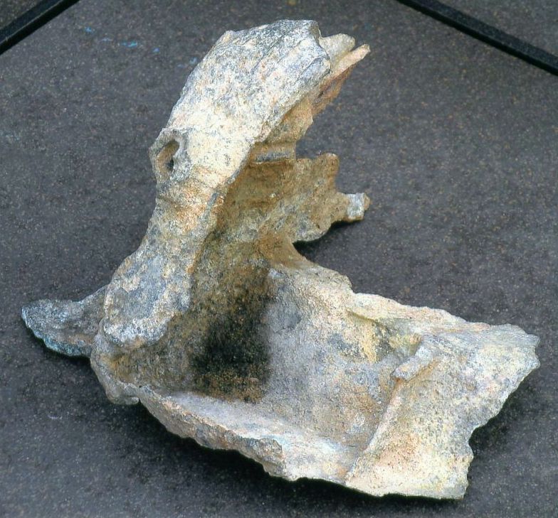
A 12/1/14 photo by Francis Blake of the remains of a possible aircraft part he found at Harper Lake, “maybe even a piece of the D-2.”
Francis reported, “After a toothbrush cleaning, some numbers &/or letters appeared.”
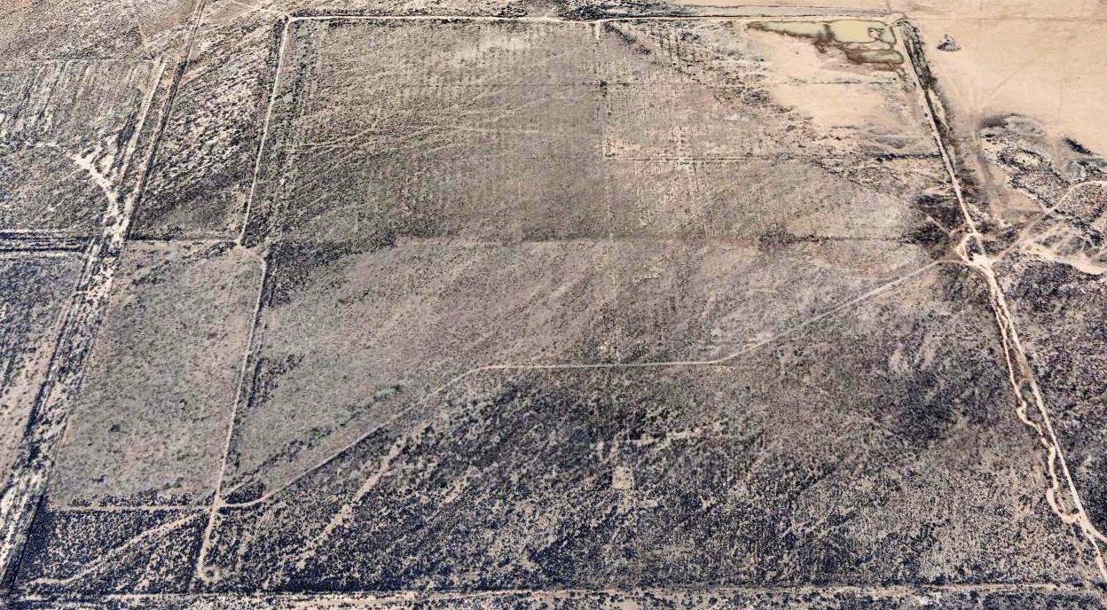
A 2022 aerial view looking north showed the remains of the 2 runways at Harper Dry Lake were much less recognizable than as seen in the 1994 photo.
The site of the Harper Dry Lake Airfield is located northwest of the intersection of Lockhart Road & Harper Lake Road.
____________________________________________________
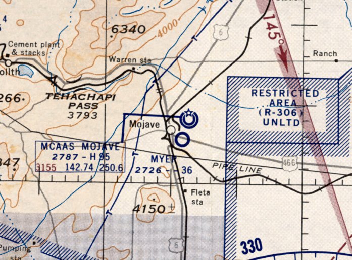
35.04, -118.162 (Northwest of Edwards AFB, CA)
A 1950 aerial view looking west, showing Myer Field at the right side (courtesy of Frank Stubbings, via Bob Alvis).
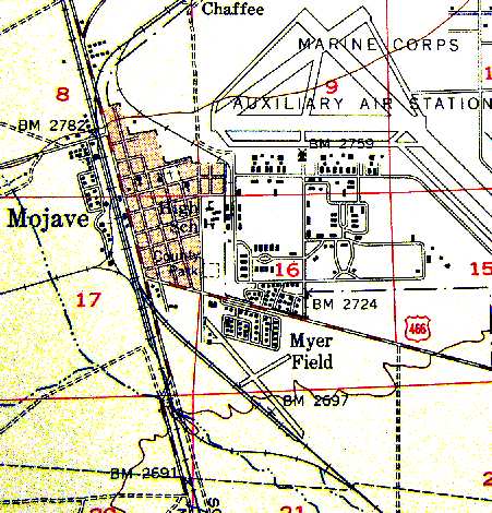
Myer Field was location along the southern edge of the town of Mojave.
It was apparently built at some point between 1949-50,
as it was not depicted on the 1949 Los Angeles Sectional Chart (according to Chris Kennedy).
The earliest depiction which has been located of Meyer Field was a 1950 aerial view (courtesy of Frank Stubbings, via Bob Alvis).
It depicted Meyer Field as having 2 unpaved runways, with 2 small hangars at the northwest corner.
The earliest aeronautical chart depiction which has been located of Myer Field was on the September 1950 LA Sectional Chart.
It depicted Myer Field as having a 4,000' unpaved runway.
A 10/13/52 aerial view (from the UCSB Library) depicted Meyer Field as having 2 unpaved runways,
with 2 small buildings & 1 light single-engine aircraft on the northwest side.
The last aeronautical chart depiction which has been located of Myer Field was on the March 1955 LA Sectional Chart.
It depicted Myer Field as having a 3,600' unpaved runway.
The 1956 USGS topo map (courtesy of Scott O'Donnell) depicted Myer Field as having two runways,
with the longest being a 4,600' northwest/southeast runway.
It also depicted the proximity of Meyer Field to Mojave MCAAS (the present-day Mojave Airport), at the top-right.
Jon Karkow reported in 2003, "Harry Myer built the field. He had a Beech Staggerwing, and his wife, Pearl, who had all the money, flew an Ercoupe.
Pearl operated a motel that was on the east side of Sierra Highway where the Oak Creek Overpass is now, just south of Kieffe & Sons Ford.
The airport operated until about the mid-1950s."
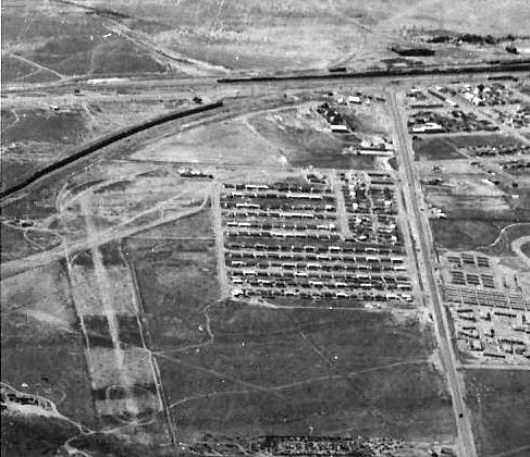
A late-1950s aerial view looking northeast at the town of Mojave,
with the runways of the MCAAS Mojave visible at the top left.
A single runway of Myer Field, along with a hangar, are barely visible at the bottom-right.
Photo from the collection of Kathy Hansen, courtesy of Jon Karkow.
Myer Field was no longer depicted on the March 1960 LA Sectional Chart.
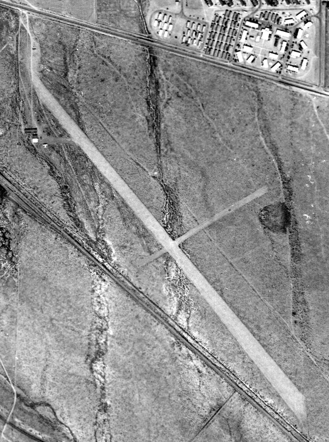
A 1972 USGS aerial view depicted Myer Field as having two unpaved runways, with a hangar on the northwest side, and another further southeast.
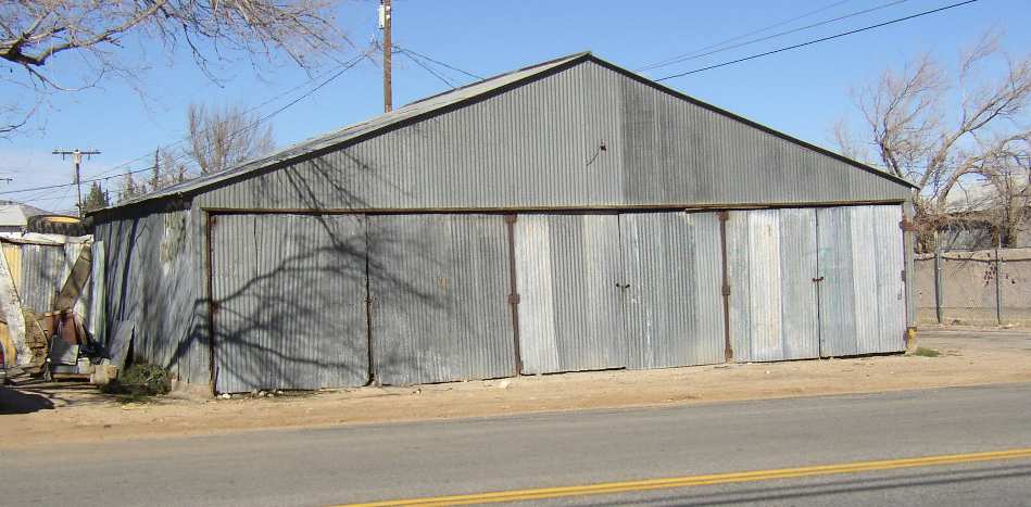
A 2003 photo by Jon Karkow of an abandoned hangar from the former Myer Field.
The hangar "is located at the south end of Myer Road, which would have been at the west end of the runway.
The hangar is now abandoned & surrounded by a chain link fence. It is of steel construction with corrugated steel siding.
The area east of the hangar was dug up in 2002 to create a drainage containment pond for the town,
totally obliterating remaining traces of the runway [on the west side of the site]."
A 2007 photo of an abandoned hangar from the former Myer Field.
A 2013 aerial view showed the former hangar remained standing on the northwest side of the Myer Field site.
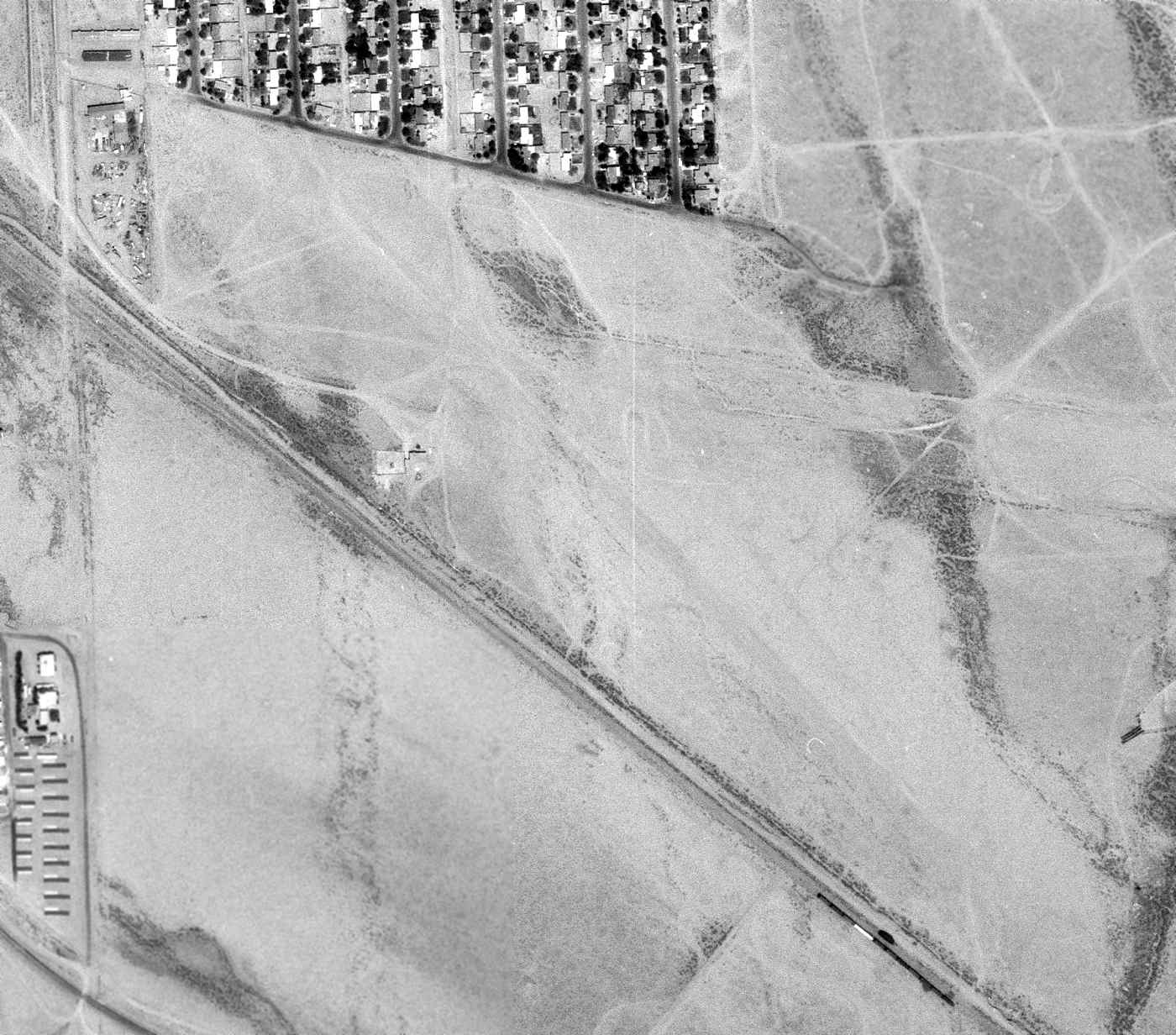
A 2015 aerial view looking south at the site of Myer Field showed the hangar on the northwest side (bottom-right) had been removed at some point between 2013-2015, with only the foundation remaining.
A drainage containment pond had covered the western portion of the former runways,
but traces of the northwest/southeast runway were still visible on the center & east sides of the site.
____________________________________________________
Mojave Inyo Airport, Mojave, CA
35.05, -118.17 (Northwest of Edwards AFB, CA)
A 1972 USGS aerial photo of the site of Mojave Inyo Airport (with the later Mojave Airport visible at top-right).
Photo of the airfield while open has not been located.
The Mojave Inyo Airport was a small airfield which was located within the town of Mojave.
Its date of construction is unknown, but according to Jon Karkow,
Mojave Inyo Airport predated the Mojave-Kern Airport (which was built in 1935, and is still in use today as Mojave Airport).
Apparently the Mojave Inyo Airport closed when the larger Mojave-Kern Airport was built adjacent to it to the east,
as only the Mojave-Kern Airport was depicted by the 1939 Sectional Chart or the 1943 USGS topo map,
and nothing of the Mojave Inyo Airport was visible in a late 1950s aerial photo of Mojave (courtesy of Jon Karkow).
A 2003 photo by Jon Karkow of a former hangar from the Mojave Inyo Airport,
which still stands (amazingly after more than 70 years) at 2037 Inyo Street.
In Karkow's words, "It is now used as a storage building for the adjacent house.
The hangar is of wood construction with corrugated steel siding.
I talked with several longtime residents & they all say that the airstrip ran along what is now Inyo Street.
This seems a little odd since it means that an aircraft departing to the west,
into the usual prevailing wind, would have to fly right over the town at low altitude."
A 2013 aerial photo shows no recognizable trace of Mojave Inyo Airport.
____________________________________________________
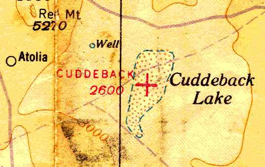
Cuddeback Dry Lake Landing Strip, Atolia, CA
35.28, -117.397 (Northeast of Edwards AFB, CA)
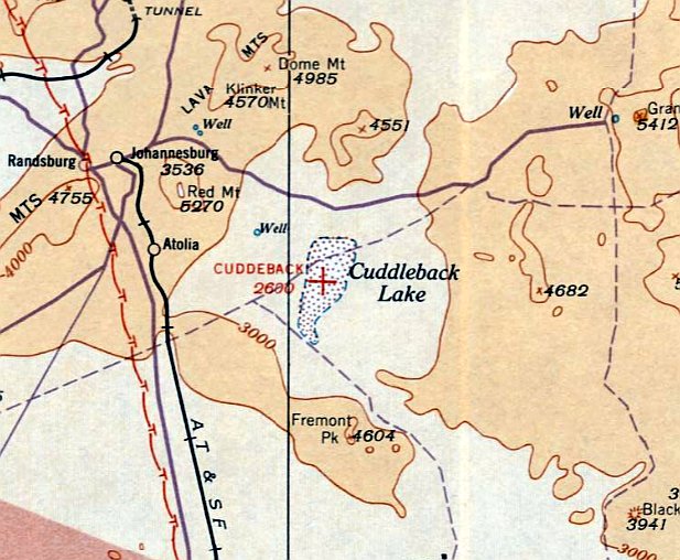
Cuddeback Airfield, as depicted on the August 1933 LA Sectional Chart.
Note that the dry lake itself was misspelled “Cuddleback”.
According to Jim Flint, “The lake was named for Leon Cuddeback, an early desert aviator & contemporary of Pancho Barnes.”
The airfield on Cuddeback Dry Lake was evidently established at some point between 1932-33,
as it was not yet depicted on the June 1932 LA Sectional Chart.
The earliest depicition which has been located of Cuddleback Airfield was on the August 1933 LA Sectional Chart.
It depicted Cuddeback as an auxiliary airfield.
The Airport Directory Company's 1937 Airports Directory (courtesy of Bob Rambo) described Cuddeback Lake Airport as a civil airport,
with a 15,840' x 5,280' (more than 3 miles long) clay landing area.
The June 1940 LA Sectional Chart (courtesy of Chris Kennedy)
depicted “Cuddeback” as an auxiliary airfield located in the middle of Cuddeback (Dry) Lake.
The Cuddeback Airfield was apparently abandoned at some point between 1940-41,
as the airfield was not depicted at all on the October 1941 LA Sectional Chart.
Former fighter pilot Jim Flint recalled, “When based at Nellis AFB in 1959
I did a low-level, simulated nuke mission that ended up with Cuddeback as the target.
I remember at the time the Navy at China Lake NAS controlled the range
and I had to call them on the 500-knot run in & get permission to drop a 25-lb practice bomb. It actually worked.”
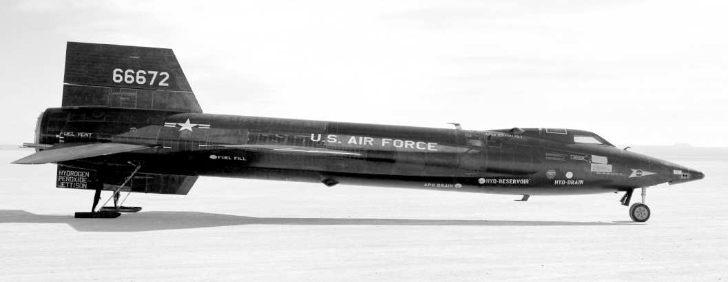
A 1962 NASA photo of the X-15-3 on a lakebed.
Cuddeback Dry Lake eventually reused as one of the designated emergency landing sites for the X-15 rocket plane.
A database of space launch sites includes entries for "Cuddeback Dry Lake"
and "Cuddeback Dry Lake Drop Zone" (southeast of the lake) as having been used by NASA/USAF from 1959-67.
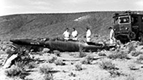
A 1967 photo of the remains of X-15-3 at the Cuddeback Lake crash site.
It had entered a Mach 5 spin, and crashed northwest of Cuddeback Lake, killing pilot Mike Adams.
No airfield at Cuddeback was depicted on the 1967 LA Sectional Chart (according to Chris Kennedy).
The site was labeled "Cuddeback Lake Air Force Range" on the 1969 USGS topo map.
In the 1960s-70s, the "Cuddeback Air to Ground Gunnery Range" was operated by personnel from George AFB,
who would be flown up to Cuddeback for a week at a time in Huey helicopters.
Bob Alvis reported that "I was at Cuddeback for a few years in the 1970s.
The air field was not advised [for landing] due to the mission statement.
Bombing & strafing by the 35th Tactical Fighter Wing & various combat squadrons pretty much chewed it up,
but on a regular basis O-2s from Ontario AF Reserve would come up & do Forward Air Control type operations, marking targets for the Thuds & F-4s.
A few times the O-2s would land but that's about it. The base during my time had two scoring towers, a motor pool barn, a small chow hall, and a small ops section.
Base of our operations was George AFB."
"Two fun facts about the place: They had more Sidewinder snakes than I have ever seen in the desert.
We felt that the rodents that called the base home multiplied so fast that their was always plenty of "snake food".
About 1978 an F-4 from George was flying across the area
with a new video guided missile to test [a GBU-35/37 HOBO TV glide bomb?]
and for some reason the missile parted ways with its hard point & was never seen again."
The 3,100' long "Landing Strip" was depicted on the 1978 USGS topo map.
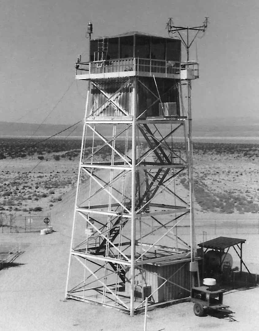
A 1983 photo by Mark Raymond “at the Cuddeback gunnery range. This is one of two scoring towers used while the range was in operation.
We were on site to erect a temporary tower so this one could be removed & relocated to a new range facility.”
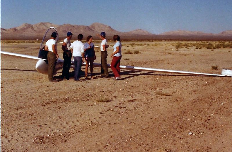
A June 1983 photo by Mark Raymond of a glider which landed at Cuddeback. Mark recalled, “He was involved in some sort of event & lost altitude.
He said it was a bumpy landing & he almost hit a guy wire in the process. We helped him dismantle & load the plane when his wife arrived.
He landed on a Saturday while the range was closed. Our tower team was the only crew out there for the weekend.
We finished erecting our temporary tower later that week.”
A 1994 USGS aerial view looking northwest at the Cuddeback Dry Lake Airfield, and the 4 target circles located to the north.
Former fighter pilot Jim Flint observed, “The old target circles never seem to fade.
The conventional range is a little less distinct but the dive bomb circles & the strafe lanes are still evident. Pretty standard arrangement for the time.”
Darrin Smith reported in 2006, “I just flew out to Cuddeback today & landed. I landed in the southwest portion, along the edge it was smooth.”
A 2014 aerial view looking northwest along the paved runway at Cuddeback, showing several small buildings along the south side of the field.
Kurtis Clark reported, “Cuddeback Gunnery Range was given back to the Bureau of Land Management by the Air Force in 2012.”
A 10/13/15 photo by Kurtis Clark of “Cuddeback Dry Lake surface looking north from approximately the center of the lake.
This surface is not as solid as some other lakes, such as El Mirage. Vehicles tear it up easily. Maybe that is why it was not used as an airfield for long.
There is a new gate installed across the road that heads east towards the runway.”
A 10/13/15 photo by Kurtis Clark of “some sort of visual target on the west side of the lake. Looking east; Cuddeback Lake is in the background.”
Cuddeback Dry Lake is located 12 miles east-southeast of Atolia, CA.
____________________________________________________
Boron Air Force Plant #72 Airfield, Boron, CA
35.054, -117.54 (Northeast of Edwards AFB, CA)
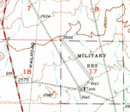
The 1954 USGS topo map depicted a single runway, labeled simply as “Military Res”.
Photo of the airfield while open has not been located.
This desert airfield is a conundrum.
No runway was depicted at this location on a 1952 aerial photo.
The site was labeled "Military Res" on the 1954 USGS topo map, which also depicted a 4,700' northwest/southeast runway.
Jeffrey Bell (Adjunct Professor of Planetary Science at the University of HI)
sent in the following hypothetical explanation about the purpose of the Boron "Air Force Plant #72".
"I believe the secret of this never-built facility is 'hidden in plain sight' -
Plant 72, had it been constructed, would have produced boron-based jet fuels for high-performance aircraft of the 1960s.
The use of boron compounds as jet & rocket fuels was a high-priority, top-secret program in both the USAF & USN during the 1950s.
A whole family of High Energy Fuels were investigated: HEF-1 (ethyldiborane), HEF-2 (propylpentaborane),
HEF-3 (ethyldecaborane), HEF-4 (methyldecaborane), and HEF-5 (ethylacetylenedecaborane)."
Jeffrey continued, "The main appeal of these exotic fuels was that they gave about 140% of the energy of JP-4 per unit weight & volume.
A side benefit (not mentioned in any discussion I have read) is that boron-6 is a great absorber of neutrons,
so a nuclear-powered airplane could use big tanks of borane compounds around the reactor as primary neutron shielding.
If the reactor failed, the boranes could be used as get-home fuel.
The B-70 design was originally predicated on using the J93-GE-5 engine with HEF-3 in the afterburners fed from separate fuel tanks.
Later, the intent was to shift to HEF-4 which could be used in the main burners as well.
The BOMARC missile program also considered shifting to HEF in its ramjets.
The Navy also made elaborate plans to store HEF or 'zip' fuel on carriers."
Jeffrey continued, "These fuels turned out to have some disadvantages:
they were very expensive to make, left solid deposits in tailpipes,
and were extremely toxic, even worse that the rocket fuels of this era.
The whole program was canceled in 1959 & the XB-70 reverted to a new high-energy kerosene fuel called JP-6.
By converting one of the 2 bomb bays into a fuel tank the original range goal could be met with JP-6."
Jeffrey continued, "So I suspect that Air Force Plant #72 would have been a chemical plant,
producing HEF-3 &/or HEF-4 from the abundant deposits of borax in the Mojave dry lakes.
The location near Edwards would be ideal to supply XB-70 or Nuclear Bomber test operations
without having to truck the deadly brew through populated areas.
And a leak at the plant would not produce a Bhopal-type disaster.
The land was probably reserved in 1957-59 & found its way onto maps, where obsolete & never-finished facilities seem to have an infinite life."
Jeffrey added that "Most of this info was cribbed from an appendix
in 'WarbirdTech Vol. 34' by the indispensable Dennis Jenkins."
The 1969 USGS topo map did not depict the runway, but a square outline labeled “Air Force Plant #72”.
The "Air Force Plant" designation is baffling, as there is no sign of any kind of industrial infrastructure at the site - nothing except the runway & a lot of desert.
A 1972 aerial view depicted Boron as having a single unpaved northwest/southeast runway.
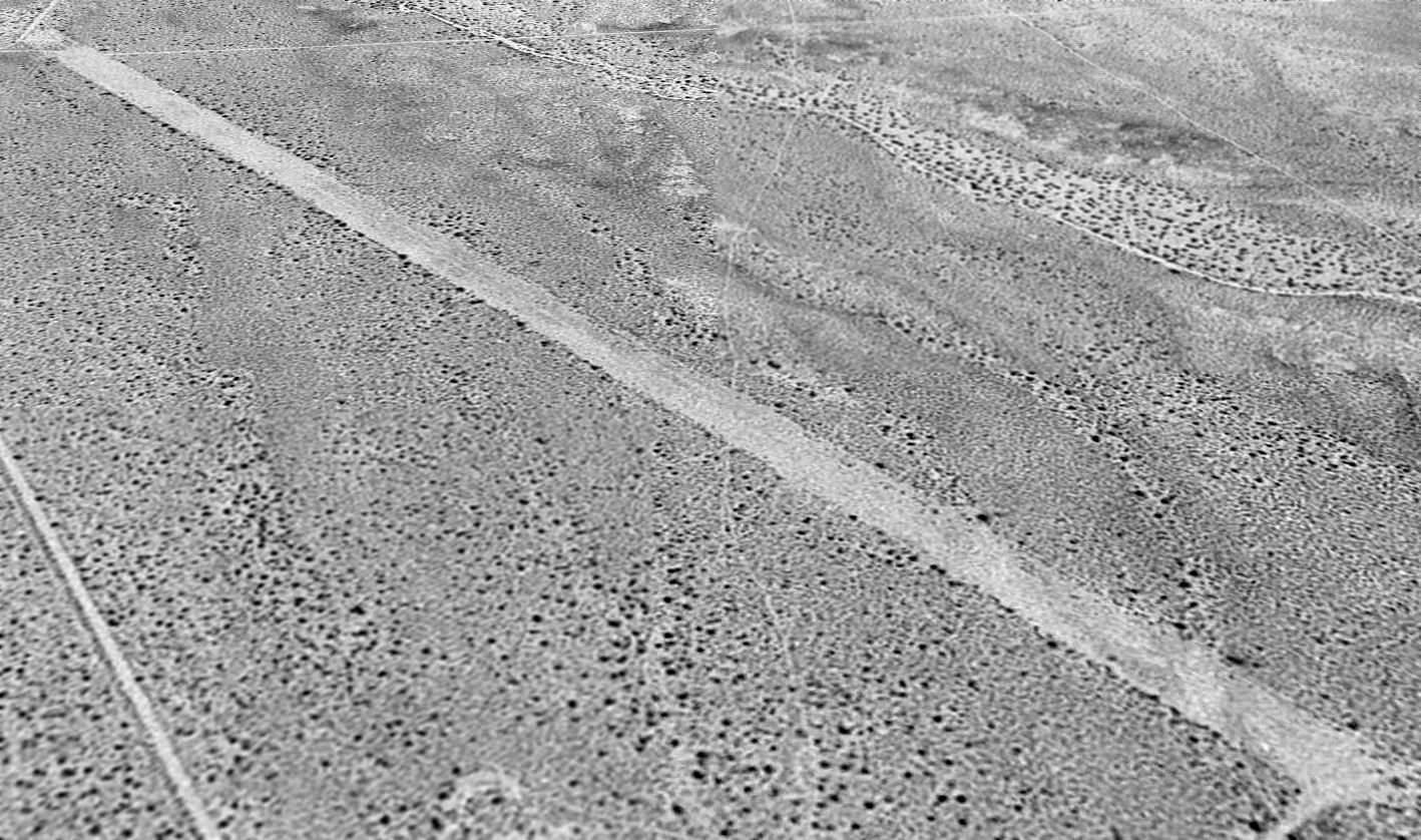
A 1994 USGS aerial view looking north depicted Boron as having a single unpaved northwest/southeast runway.
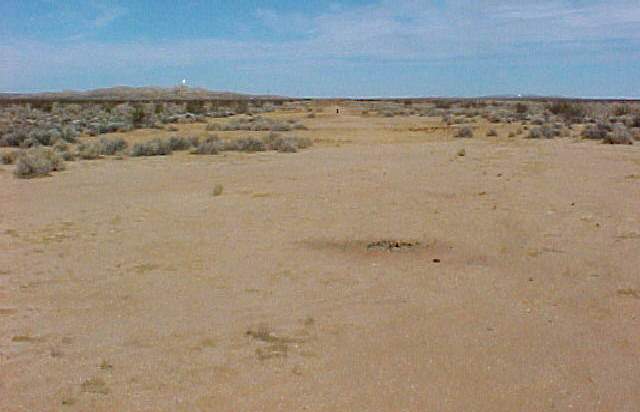
A 2002 photo by Jon Vanover, looking north along the Boron runway.
Jon reported, “The runway appears to be older than the fences & roads as they overlap the runway at the north & south ends.
Along the east side there is a road that runs north & is lined with the bottoms of cut down utility poles.
Several fences along the way but no clues to what this place was."
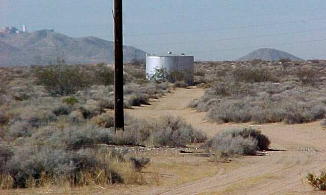
A 2002 photo by Jon Vanover of the water tank at Boron.
Jon confirmed that the only thing at the site "is a dirt field, water tank & pump building.”
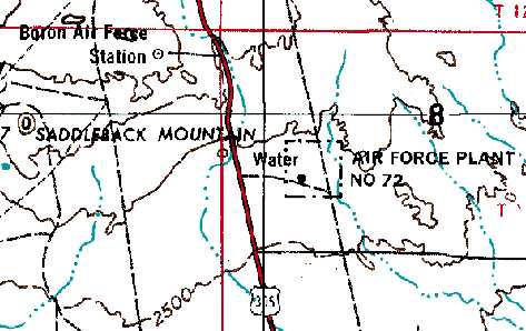
The Boron Air Force Station, an early-warning radar installation, was located 4 miles northwest, on the opposite side of Route 395.
The Air Force Station operated from 1952-75, and the site is now used by an FAA radar.
It is possible that the runway at "Plant #72" was built to support the nearby radar station,
as there are some other examples of this being done (like the runway at Cape Charles AFS, VA).
But it is also possible that the runway was built to support the planned (but never built) "Air Force Plant".
The dates of construction & closure of this airfield are just as baffling as everything else about it.
Although the Boron Airfield was depicted on the 1973 & 1976 USGS topo maps,
no airfield at all (not even an abandoned airfield) was depicted at this location on aeronautical charts from 1944, 1949, 1964, 1967, or 1998.
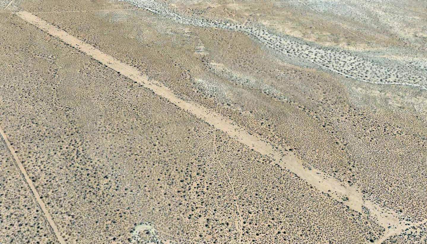
A 2015 aerial view looking north depicted Boron as having a single unpaved northwest/southeast runway.
Boron Air Force Plant #72 is located southeast of the intersection of Route 395 & Palmetto Street, four miles north of Kramer Junction.
Thanks to Jon Vanover for pointing out the Boron Airfield.
____________________________________________________
____________________________________________________
This site covers airfields in all 50 states.