
Abandoned & Little-Known Airfields:
California: East Los Angeles Area
© 2002, © 2025 by Paul Freeman. Revised 1/21/25.
This site covers airfields in all 50 states: Click here for the site's main menu.
For a 10th year, the CA pages of this website are sponsored by the California Pilots Association:
____________________________________________________
Please consider a financial contribution to support the continued growth & operation of this site.
Alhambra Airport / Western Air College Airport (revised 10/14/22) - Altadena Airport (added 1/30/22) - Bellflower Airport (revised 1/21/25) - Burnley Airport / Pomona Airport (revised 5/21/22)
Delpert Airport / Norwalk Airport (revised 4/12/23) - Foothill Flying Field / Monrovia Airport (revised 5/21/22) - Puente Sky Ranch / Zephyr Skyranch (revised 5/21/22)
Western Air College Airport / Rosemead Airport / Fletcher Airport (revised 11/21/23) - Ross Field / Arcadia Intermediate Landing Field / Mission Field (revised 12/10/24) - Shepherd Field (revised 4/10/21)
____________________________________________________
Altadena Airport, Altadena, CA
34.183, -118.118 (Northeast of Los Angeles, CA)
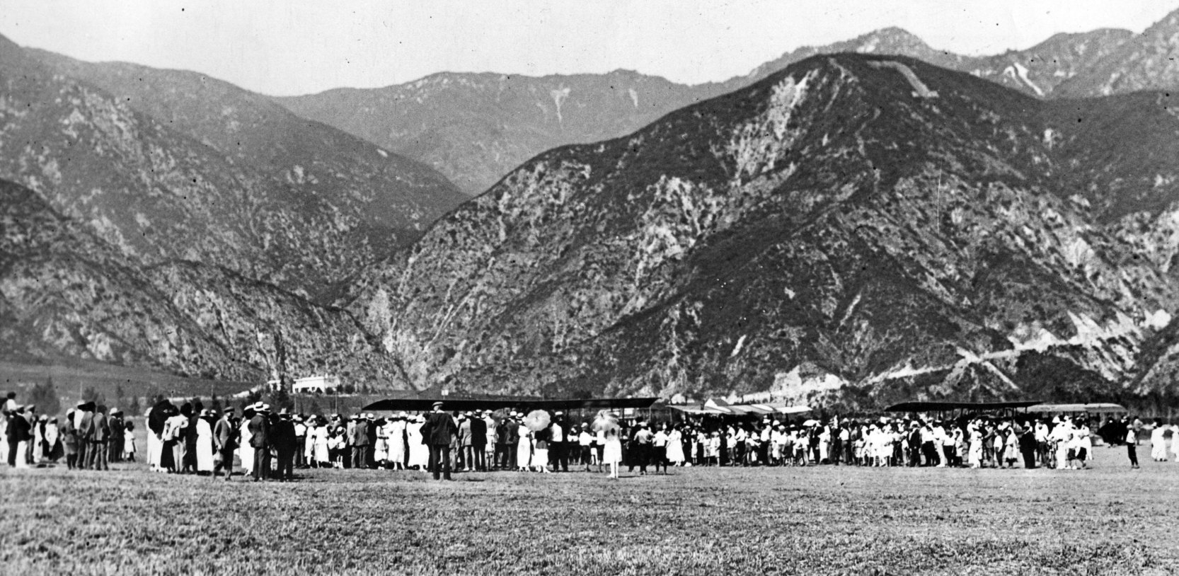
A circa 1919-21 photo of a crowd & several planes at Altadena Airport (courtesy of the Altadena Historical Society, via Dan MacPherson).
According to the Altadena Town Council, “There was an airport adjacent to the country club that was established by Cecil DeMille [in 1919].”
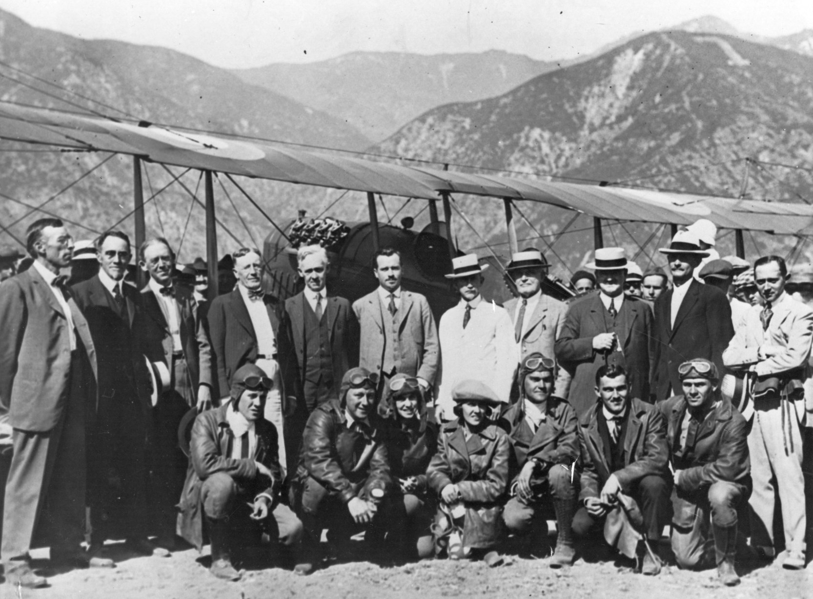
A circa 1919-21 photo of Cecil DeMille & other pilots in front of a plane at Altadena Airport (courtesy of the Altadena Historical Society, via Dan MacPherson).
Others pictured included Robert Kennedy, Jeannie MacPherson, Gloria Swanson, David Thompson, Ken Montee, and Donald McDaneld.
According to the Altadena Town Council, Altadena Airport only operated for a mere 2 years, ceasing in 1921.
Altadena Airport was not depicted on the 1928 USGS topo map, which instead just depicted the Pasadena Country Club.
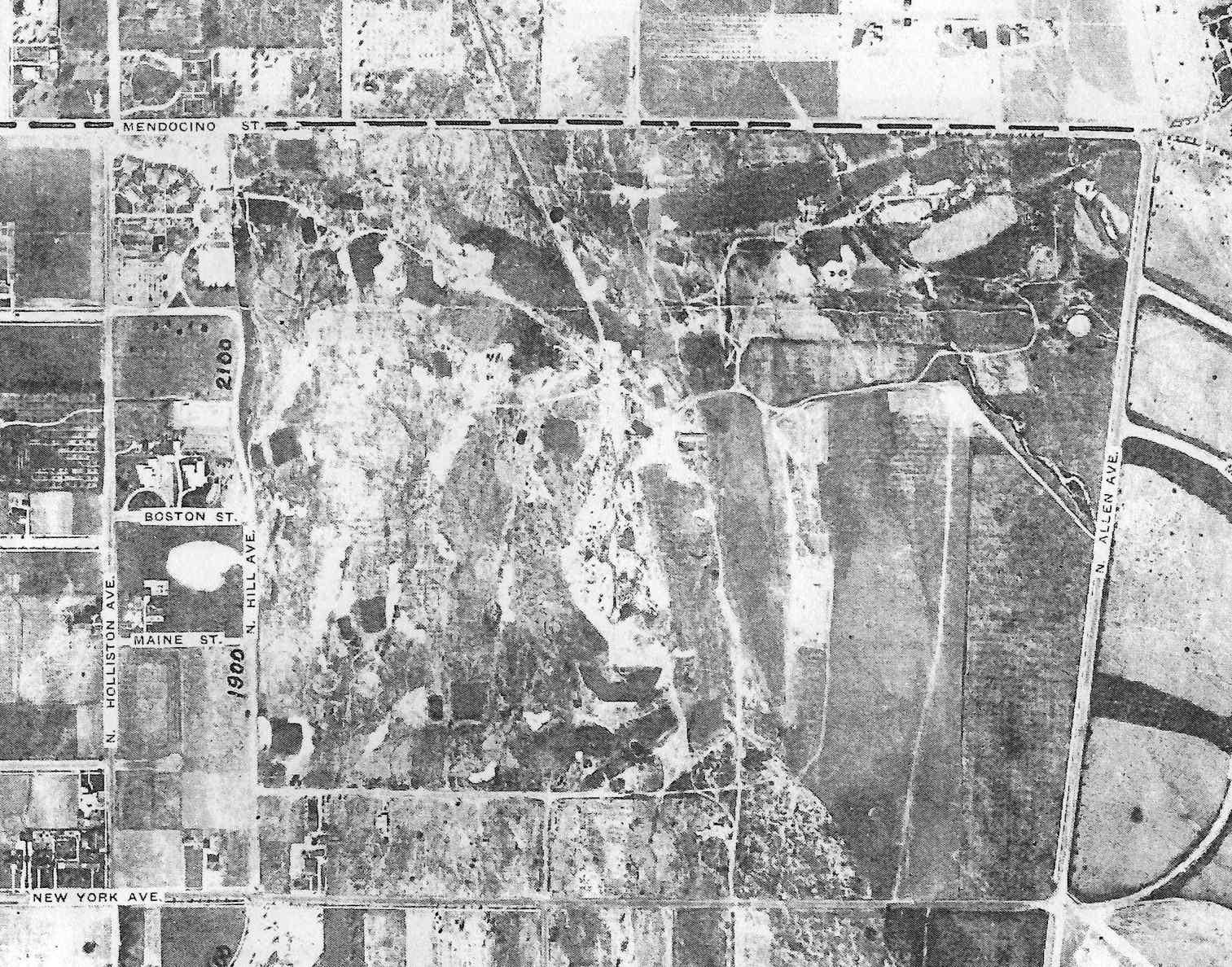
An undated aerial view of the site of Altadena Airport (courtesy of the Altadena Historical Society, via Dan MacPherson).
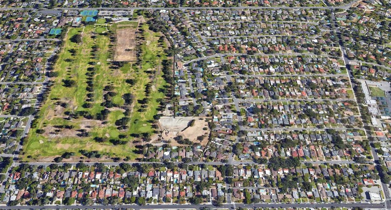
A 2021 aerial view looking north showed no trace remained of Altadena Airport.
Thanks to Dan MacPherson for pointing out this airfield.
____________________________________________________
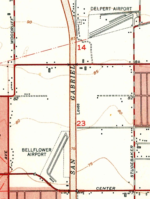
Delpert Airport / Norwalk Airport, Norwalk, CA
33.907, -118.103 (North of Long Beach, CA)
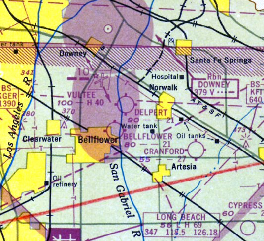
Delpert Airport, as depicted on the 1947 LA Local Aeronautical Chart (courtesy of Tim Zukas).
This short-lived little general aviation airport was evidently established in 1946.
A 1/7/46 LA Times article (courtesy of Dick Morris) reported that “An airport at Leffingwell & Studebaker Roads will start operation in the next 2 weeks,
Dr. C.M. Brackensick, who with Fletcher Delk & Eugene Lieppert, is drawing up plans for the port, accounced today.”
Delpert Airport was not yet depicted on the February 1946 San Diego Sectional Chart.
The earliest depiction which has been located of Delpert Airport was on the 1947 LA Local Aeronautical Chart (courtesy of Tim Zukas).
It depicted Delpert as having a 2,100' unpaved runway.

The earliest photo which has been located of Delpert Airport was a 5/1/47 aerial view (courtesy of UCSB Library Geospatial Collection, via Dick Morris).
It depicted a single northeast/southwest unpaved runway, and several dozen light aircraft parked on both sides.
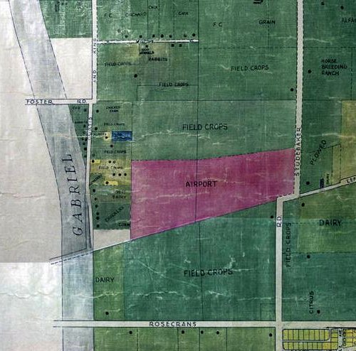
A 1948 country property map (courtesy of Dick Morris) depicted Delpert Airport as an east/west oriented outline.
The September 1948 San Diego Local Aeronautical Chart (courtesy of Chris Kennedy)
depicted Delpert Airport as having a 2,100' unpaved runway.
The last photo which has been located of Delpert Airport was a circa 1950 aerial view looking southeast (courtesy of Dick Morris).
It depicted a northeast/southwest runway, with several buildings/hangars.
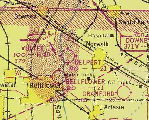
The 1951 USGS topo map depicted Delpert Airport as having a northeast/southwest runway with a parallel taxiway
and a few small buildings on the north & east sides.
Delpert Airport was evidently renamed Norwalk Airport at some point between 1948-51,
as that is how it was labeled on the March 1951 San Diego Sectional Chart (courtesy of Chris Kennedy).
It depicted Norwalk Airport as having a 2,500' unpaved runway.
Norwalk/Delpert Airport was evidently closed by 1951, as Dick Morris recalled, “They were selling houses on the site in August 1951.”
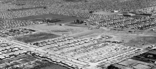
A 1953 aerial view showed dense housing covering the site of Delpert Airport.
Delpert Dick Morris reported, “Delpert Airport... I was raised about 6 blocks from it, but was only about 3 years old when it was converted to tract housing.
During the 1947-55 period there were massive numbers of hew houses built in Norwalk, mostly on former agricultural land.
It appears to have lasted for no more than 5 years.”
A 2017 aerial view showed no trace remaining of Delpert Airport.
Thanks to Dick Morris for pointing out this airfield.
____________________________________________________
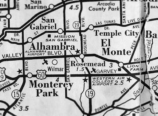
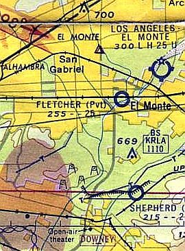
Western Air College Airport / Rosemead Airport / Fletcher Airport, Rosemead, CA
34.071, -118.06 (West of El Monte Airport, CA)
A 1942 street map (courtesy of Gary Alexander) depicted the Western Air College Airport.
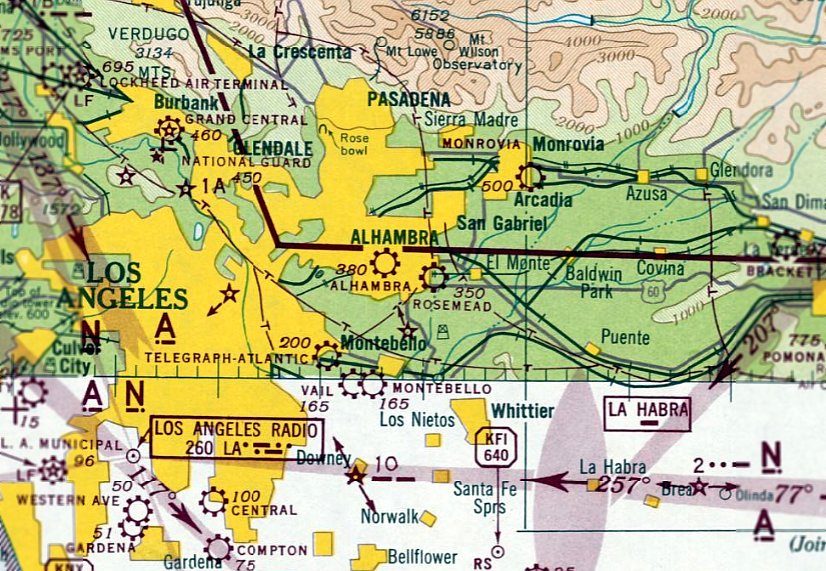
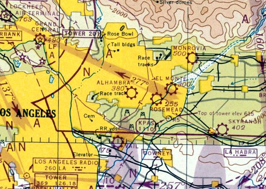
Rosemead Airport is yet another of the vanished former airports which once were spread all throughout the Los Angeles metropolitan area.
It was located roughly in between Alhambra Airport & El Monte Airport.
The airport at this location in Rosemead was apparently built at some point between 1941-42,
as it was not depicted on the October 1941 LA Sectional Chart.
The earliest depiction of an which has been located of this airport in Rosemead was on a 1942 street map (courtesy of Gary Alexander),
which labeled the field as the Western Air College Airport.
At some point in 1942 the airport was evidently renamed Rosemead, as that is how it was labeled on the April 1942 LA Sectional Aeronautical Chart.
A flying school at Rosemead Airport was operated by Etienne Noir, who also owned Puente Sky Ranch (according to a March 1946 article, courtesy of Dan MacPherson).
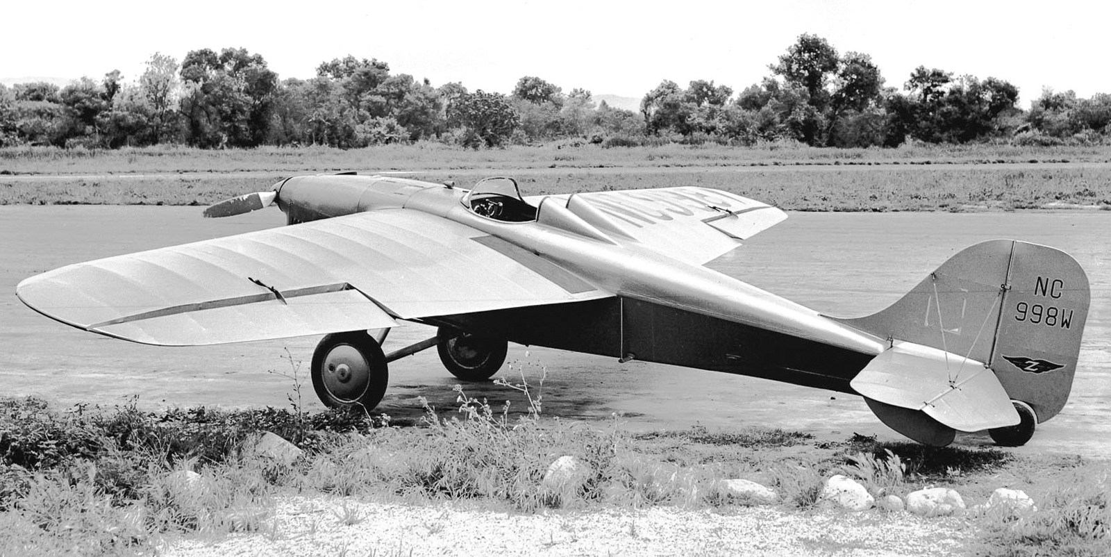
A 5/21/46 photo by William Larkins of a pretty Babcock LC-13 Taubman NC998W C/n 601 at Rosemead Airport.
The LC-13 had a 75 hp Roche Rover L-267 engine.
The 1946 Thomas Brothers Map of LA (courtesy of Dan MacPherson) depicted Rosemead Airport as a rectangular property located along the Rio Hondo.
The 1947 LA Local Aeronautical Chart (courtesy of Tim Zukas) depicted Rosemead Airport as having a 3,000' unpaved runway.
Abram Karl reported, “I own a 1947 North American Aviation Navion. It was owned by Walter Slezak (the actor) & based at Rosemead Airport.
Later it was sold to Stuart Oliver (1950), still based at Rosemead.
Oliver only owned the airplane for a few months before selling it to Louie Lombardo & Harold Russell. They kept the airplane at Rosemead.
The final owner of my airplane who kept the airplane at Rosemead was Joe & Cathy Kirkwood. The airplane departed Rosemead in 1954.”
The FBO at Rosemead in the late 1940s was Gus Gehrig.
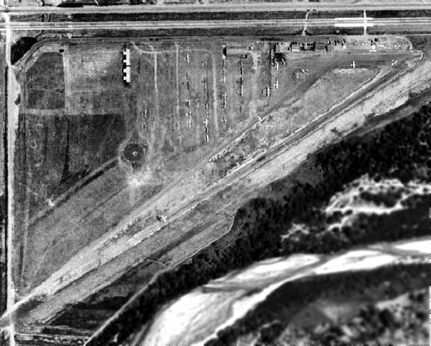
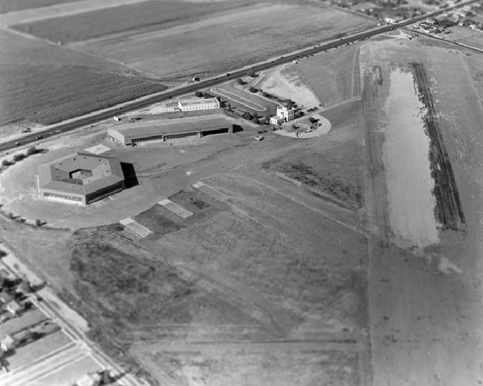
A 1948 aerial view depicted the Rosemead Airport as having a single unpaved northeast/southwest runway,
with several hangars along the north side of the field.
Dozens of light aircraft were visible on the field, including several on the runway & taxiways.
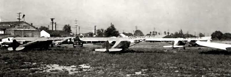
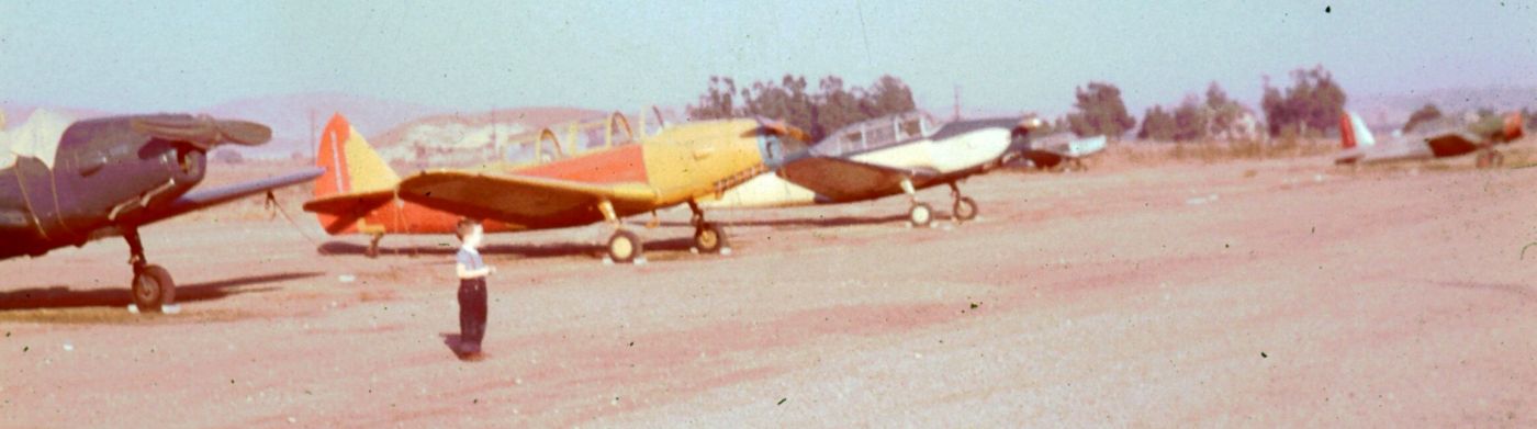
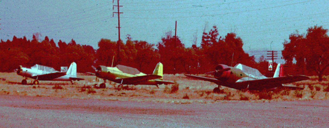
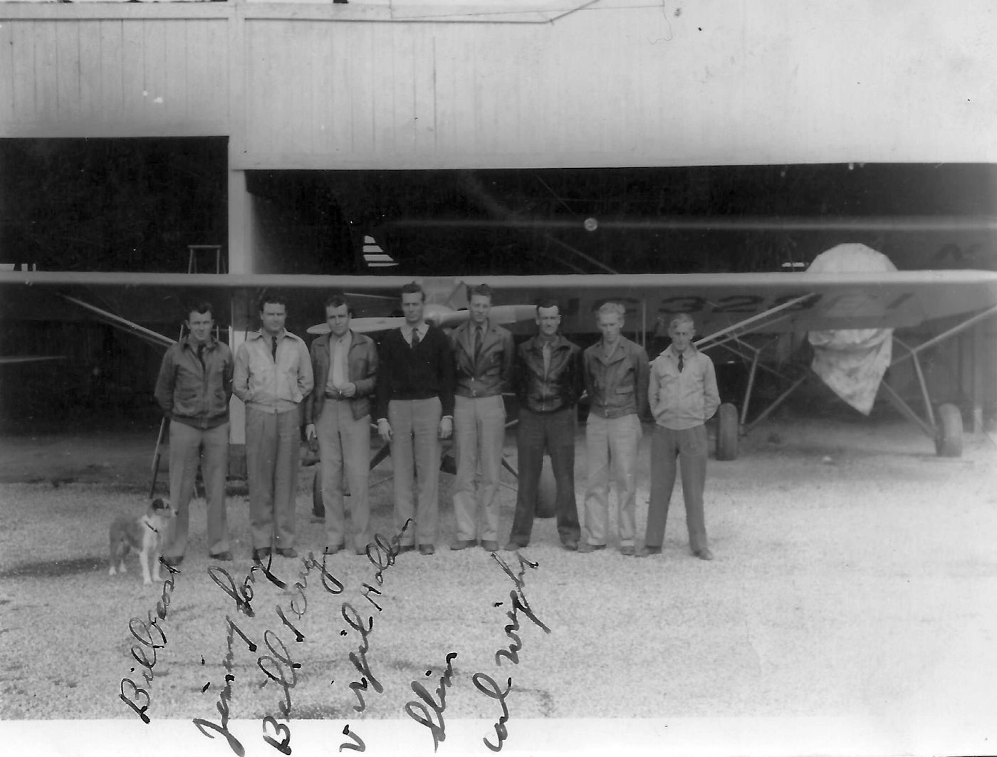
A circa 1940s photo (courtesy of Bob Cannon) of an assortment of single-engine planes at Rosemead Airport.
Bob Cannon recalled, "I made my first airplane ride out of Rosemead in 1948. We went all the way to Brackett in a new Stinson.
Four of us split the $12 hourly rental rate that Gus Gehrig charged.
Back in the L16 days I bumped into a guy at the local donut shop who turned out to be the owner of Rosemead back then.
He & his brother bought the field after WW2, and another in the high desert. The Heasley brothers did own Rosemead Airport."
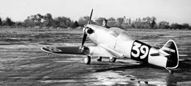
A circa 1947 photo (courtesy of Bob Cannon) of Mike Argandar at Rosemead Airport behind the midget racer he built.
A circa 1950 photo of Joe White with his Monocoupe at Rosemead Airport (courtesy of Dan Rhinehart).
Lloyd Duke recalled, “The Heasleys sold the airport to Fletcher Aviation Company.
The company built dropable aircraft fuel tanks & napalm bombs for the fighter planes used in the Korean War.
The war was still going on & their products were in high demand. They needed more manufacturing space.
Building construction started immediately in a location just east of Hardwick's place.
Hardwick began moving his junk to a location in South El Monte.
In the moving process I was surprised to see that he had 2 brand-new Me109s in Spanish Air Force markings still in their crates.
Fletcher's future plans were to build a Porsche-powered jeep for the Army,
an agriculture plane & a spin-off of that plane as a small close ground support aircraft for the Army, Air Force and Marines.
The owners were 2 brothers, Maurie & Stan Fletcher. They were nice people.”
Lloyd continued, “It was a cold overcast blustery Saturday morning.
My brother Ernie & I saw Hardwick opening Fletcher’s back entrance gate to their factory property.
Some of his planes that were flightworthy were inside the fenced area.
He drove his Chevy pickup to the P-38 that was parked close to the east side of the fenced area.
We knew this meant some excitement was to be had there. We went over to the fence & found some boxes to set on.”
Lloyd continued, “Jack looked to be ready for flight because was wearing his flight jacket,
a squashed up baseball hat, and the half-smoked cigar chomped in his teeth.
He walked around the plane preflight style, you know like kicking the tires, looking in the wheel wells,
checking hatches, moving control surfaces, shaking them, looking at hinges, the blowers (super chargers) etc.
He went back to the El Comino & got a ladder & a fuel checker.
He proceeded to check the oil & engine condition on each engine. We were getting excited. He was going to go flying.
The engines cowling buttoned-up he went under each engine & bled some fuel to check for water.
Continuing he checked the wing tanks for water, removed the tie down ropes & removed the wheel chocks.
He put the ladder fuel checker back in the El Comino, drove it around to the rear of the plane, parked it, and got out with a stick.”
Lloyd continued, “He walked back to the cockpit & lowered the steps located at the rear of the center fuselage.
He climbed the steps, opened the hatch door, reached in & did some arranging.
He then walked out on the left wing opened the fuel tank fill cap, used the stick to check the fuel level,
closed the fuel cap & banged it with the heal of his hand.
He went back to the cockpit, slid over the rear end of the cockpit, and checked the right tank.
Apparently satisfied, upon returning to the cock pit he threw the stick on the ground, slid back over the cockpit, retracted the steps & climbed in.
These steps are a neat deal. They can be raised & lowered from the bottom or the top.
When the steps are lowered from the bottom a handrail that is linked to the steps raises up on top.”
Lloyd continued, “After some fiddling around, he moved the controls, ailerons left & right, elevator up & down,
rudders left & right, blower cowls open, flaps fully extended then retracted to about 1/3 position.
The left engine started turning. After several turns, it popped & belched, caught & smoothed out running nicely, the black & white smoke cleared quickly.
That was surprising after such a long time without being run.
The right engine started to turn popping & banging as the left engine did,
but suddenly he shot up out of the cockpit like a helicopter, cigar firmly chomped in his mouth,
he ran out on the left wing his hat blowing off, the right engine working its way through to running smoothly,
as Jack jumped off the left wing, sailing through the air, his arms flailing, he hit the ground running & stopped about 50 feet away.
He turned, standing, one hand on his hip the other scratching his head, cigar still chomped in his teeth.
The smoke form the starting engine now was clearing & blowing away.
After a couple of minutes the P-38 setting alone, running nicely, he shook his head & began walking back to the plane, picking up his hat on the way.
Hat clutched in his hand he lowered the steps, climbed up into cockpit.
Setting back into the seat, rearranging his hat on his head, some more fiddling, he began running up the left engine, checking mags & cycling the props.
He repeated this on the right engine. He ran the engines for about 10 minutes then shut them down.”
Lloyd continued, “It was just killing us to ask what happened, but knowing his disdain for kids, we just watched & wondered.
Hardwick buttoned up the cockpit, popped put the steps, climbed down, tucked up the steps, and replaced the chocks, giving each a good kick.
He tied the plane down & drove away. What scared him? I don’t know. Just another day in aviation.”
Lloyd continued, “Bill Shepherd was a recluse kind of guy at the air port. No nonsense, always in a hurry, just in & out of there.
He was the owner of a Republic SeaBee that was always parked south of the apron on the north side of the entrance to Hardwick’s stuff.
Just about the time Fletcher bought the airport Bill bought a beautiful Beechcraft Twin Bonanza.
He built a hanger next to Gus’s Flying Service at the very east end of the parking apron.
The Twin Bonanza was kept in the hangar & to the east side of the hangar was a Republic SeaBee's new parking place.
The SeaBee had a couple of feet of wing grafted on to increase the lift.
As I say, he was always in a hurry. He would never make eye contact.”
Lloyd continued, “One day he showed up in his really nice car, I think a 1952 Cadillac convertible, wearing a bathing suit & T-shirt, and barefooted.
He removed a Number 10 galvanized tub, an Arvolet spear gun, a tire iron, mask & swim fins.
All this was loaded into the SeaBee. He took off & returned an hour & a half or so later with the tub filled with live lobster, abalone & a couple of nice sea bass.
The propeller on the sea plane was fully reversible for ease of handling on the water.
He used this trick to back the plane into its parking spot. Engine shut down he would first open the petcock at the aft of the float to drain the hull bilge water,
tie the plane down, get out the garden hose & squirt down the whole plane bilge & all to get the seawater off.
The tub tucked into the Cadillac off he went.”
Lloyd continued, “The first time I was able to talk to him, he had just returned from one of his many trips to the ocean.
On this occasion, I decided to be a little pushy & see if I could take care of washing & draining his plane.
I explained that I was a belly washer, plane washer & what ever for many planes on the field.
He said OK & commenced to explain what he wanted me to do. He did not want me to bother with his Twin Bonanza.
I asked where he had caught all the lobsters & he said Catalina. I asked whether he had far to go to get home.
He said San Marino. Turns out he was a nice person. He never did let me work on his Bonanza.
I always thought he was a cool guy, doing what most people only dream of doing.”
Richard Franklin recalled, “I lived from 1952-60 just off of Ramona Boulevard, which ran along North side of the Rosemead Airport.
Pacific Electric had a rail line between Ramona Boulevard & the airport that ran from LA out to Pomona.
The Civil Air Patrol had the most activity at the field in the early 1950s.
There were only 2 buildings (no hangars) on the field at this time.
These buildings can be seen in the movie 'Court Marshal Billy Mitchell' starring Gary Cooper.
The airport was also the home for the Goodyear Blimp when they first brought it to California in the mid 1950s.”
According to Lloyd Duke, “Fletcher wanted to get into the aircraft business with a passion.
There were several tries before my entry on the scene. In 1951 they had partnered with an aeronautical engineer by the name of John Thorp.
John Thorp had traveled far & wide as an aeronautical engineer in the aviation background of California, with his associations with Boeing & Lockheed.
He brought one of his ideas developed during his Lockheed time to Fletcher Aviation.
Fletcher built 2 planes based upon Thorp's designs.
One was the FD-25 Fletcher Defender, and based upon it the FU-24 Fletcher Utility Agwagon.
The planes were very similar having the same engine cowling, wing, and empennage.
Of course designing & building them was just part of the problem.
Examples of each had to be taken into the sky & tested &/or evaluated to qualify the plane for flight.
The planes had to be clearly marked by the cockpit, 'Experimental', and only Experimental Test pilots could fly them.
Fletcher selected Bob Downey to be the Experimental Test Pilot.”
Llloyd continued, “Flight testing day come, fortunately it was during summer vacation.
I was there early on testing day. Fletcher had set up a canapé tent & parked next to it was the instrument & communications truck.
There were several of those folding directors’ chairs set around there. Both the Defender & the Agwagon were parked nearby.
It is test day & the festivities begin with the entry of Bob Downey who drives up to the tent in 1950 Ford Business Coupe.
He is wearing a business suit & is the tall lanky Downey of Los Angles Times fame.
While he is talking to the people in the test van he was putting on his white flight suit, parachute, helmet & goggles.”
Llloyd continued, “The first plane he goes for is the Defender FD-25.
In my research there is controversy as to which engine the Defender was tested with.
The test flight area is the Whittier Narrows. At the time there was nothing there but river & swamp where the San Gabriel & Rio Hondo Rivers meet.
This area is just 3 miles south of Rosemead Airport.
It was close enough for a power-out glide, dead-stick landing distance from the flight test altitude to the airport property.”
Llloyd continued, “The actual flight testing involved a lot of radio conversation between Downey in the plane & the engineers on the ground.
Everything went nicely & boringly until the high-speed dive.
There was a flutter in the horizontal stabilizer at a speed that should have been well within the yellow arc.
He landed & a long discussion ensued with the engineers.
The next morning the engineers had mounted some aluminum arms adjacent to the inboard hinge
at the bottom side of the leading edge on the elevator with lead torpedo weights riveted to them.
He went back up & into the high speed dive. The flutter was eliminated.
I think the elevator was replaced with a stronger one because the next time I saw the Defender the weights were gone.”
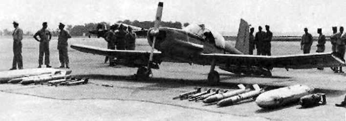
A circa 1950s photo (courtesy of Lloyd Duke) of a Fletcher FU-25 Defender prototype at Rosemead Airport.
Lloyd recalled, “Fletcher had a show & tell & flight demonstration that I was lucky enough to witness.
There were a lot of military people in attendance.
There were Generals from the Air Force, Army and the Marines, as well as lower officers, all pilot or aviators.
The highest General was 3-stars. This picture was taken of that event at Rosemead Airport. I was present when this picture was taken.
Fletchers laid out some Astroturf & placed the display on it. This was laid out in front of the Civil Air Patrol Hut.”
In the background is the Agwagon, with a C-47 to the right of it. Lloyd recalled, “Some of the generals came in the C-47.”
Llloyd continued, “Of the 2 planes the Agwagon was the most successful.
The military apparently did not want a cheap, utility, close ground support spotter plane.
In that I was disappointed. I thought it was a great idea.
Fletcher sold the Agwagon to Cable Price Corporation, A New Zealand Company.”
Llloyd continued, “At this same show Fletcher showed its 'Jeep' offering.
It was an amphibious 4-place small car powered by a Porsche engine.
They built a muddy water pit for it to drive through, they ran it down the runway & turned it on a dime,
and they ran it down in the river with generals riding to demonstrate its rough abilities.
This was all to no avail. No jeeps were sold to the military.
It was a neat combination in my opinion. Would have been better than the Humvee & a lot cheaper.”
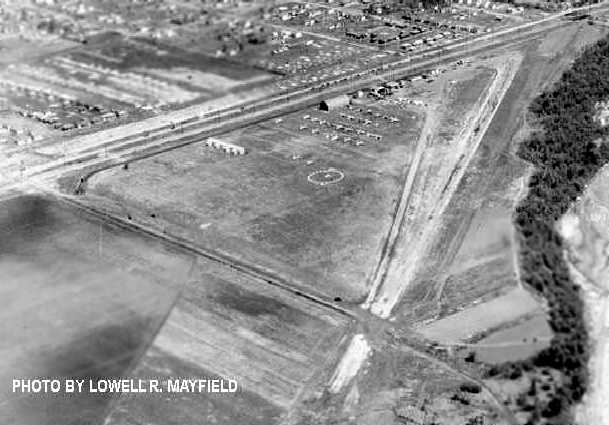
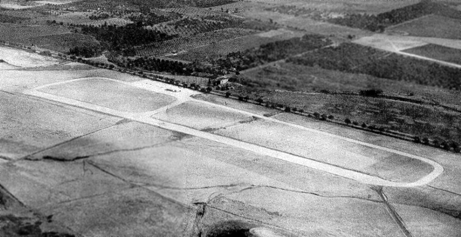
A circa 1950s aerial view looking northeast at Rosemead Airport by Lowell Mayfield (courtesy of Bob Cannon).
It appeared as if the northeast/southwest runway extended beyond Rio Hondo Avenue in the foreground of the picture.
Lloyd Duke recalled of Rosemead Airport, “In 1952 an old dusty Reflex bus showed at the airport.
It had a lot of bags & duffel on top of it, but the most curious was an extendable pole
that was attached to a pedestal mounted on top & that was folded down forward along the centerline of the top of the bus.
The bus had a big sign painted on the side, 'Goodyear'.
It was the kind of bus from the 1930s used by Greyhound, that looked like a big sow bug,
streamlined tapered on the back & with big streamlined finders painted on the sides.
It was parked over by Hardwick’s stuff on the east side if the large old tiedown area.
The 2 people on the bus were picked up by a car that was following it. Hmmm, another mystery coming?”
Lloyd continued, “By this time Fletcher had cleared out all the old derelict planes
and there was quite an open space between Hardwick’s, Fletcher’s new factory construction & the west side of the airport apron.
The next day I could not wait to get out of school & get to the airport to see what was happening.
On my arrival there, the bus was parked out in the center of the open area between Hardwick’s & the flight line to the west side of the apron.
The stuff & duffel was stacked where the bus had been parked yesterday.
There were many big milk cans & compressed gas bottles, helium I guess.
The mast on the bus was extended, upright & tied-down with guy wires.
I asked one of the men working there what they were doing.
He said the Goodyear Blimp was coming & would be here soon. The bus was a portable tiedown place for the Blimp.
It had to allow the blimp to behave like a weather vane; always pointing into the wind when it was not flying.
It needed a large circular swing area. Later there would be a more permanent tether tower.”
Lloyd continued, “I was asked if I would help them land the blimp when it arrived. Of course I said sure.
At the time I was a big person, overweight, just what it turned out they needed.
There were 8 ropes hanging from the front of the blimp.
A man was to grab one rope & working together direct the nose of the blimp into a hookup on the tether pole.
Wow, the blimp arrived & I went into action with the other men there & helped maneuver the hookup of the Blimp to the mast.”
Lloyd continued, “The blimp arrival & landing is an adventure.
The thing is coming toward you, moving up & down & sideways, always getting closer, but slowly.
The engines were two 165 horsepower Warner 7-cylinder radial engines.
The 2-blade propellers were fully reversible to give a little more control at low speed & low altitude in the landing area.
As the ropes from the nose become reachable you grab one & run away,
forming a circle around the nose, like 4 ropes on the left & 4 ropes on the right.
You keep your rope tight but not so tight that you pull the nose into the ground. You try to keep the nose tether hook high.
There is a landing coordinator shouting out orders to each of the landers.”
Lloyd continued, “In talking with the landing crew I found out the blimp would move to Tustin naval blimp hangars
to go through the helium regeneration process.
It seems the blimp had just come from Miami, Florida.
In flying across the southern route, over Florida, Alabama, Mississippi, Louisiana, Texas, New Mexico, Arizona and California,
several people could not resist taking pot shots at the bag.
It turned out there were 21 holes requiring patches.
One shotgun hit was received in the gondola.”
Lloyd continued, “My younger brother Ernie & I were hired to be blimp watchers & landers.
That was short-lived because a couple of guys, seniors, from high school wanted jobs on the Blimp.
They told the Goodyear people we were not 16 years old. That was true, I was 15 & Ernie was 14. That ended that.
I had made acquaintance with the 2 pilots. One was a nice guy & took a lot of time to explain things to my brother & me.
His name was John Hobansack. He had learned to fly the blimps in the Navy during the Second World War.”
Lloyd continued, “The milk can mystery was that they were actually gasoline cans.
It was difficult to fuel the blimp because there was no fuel truck at the airport,
so the cans were used to fuel the blimp on the ground & extras were carried in the gondola during flight as extra fuel.
With more passengers some of the cans would be removed to compensate for the weight.
On the lower quadrants of the sides of the air bag was an array of lights that were controlled from a tape inside the gondola.
I never did see a tape made, but I guess it was like a typewriter code that could make animated information to be written out by the lights.”
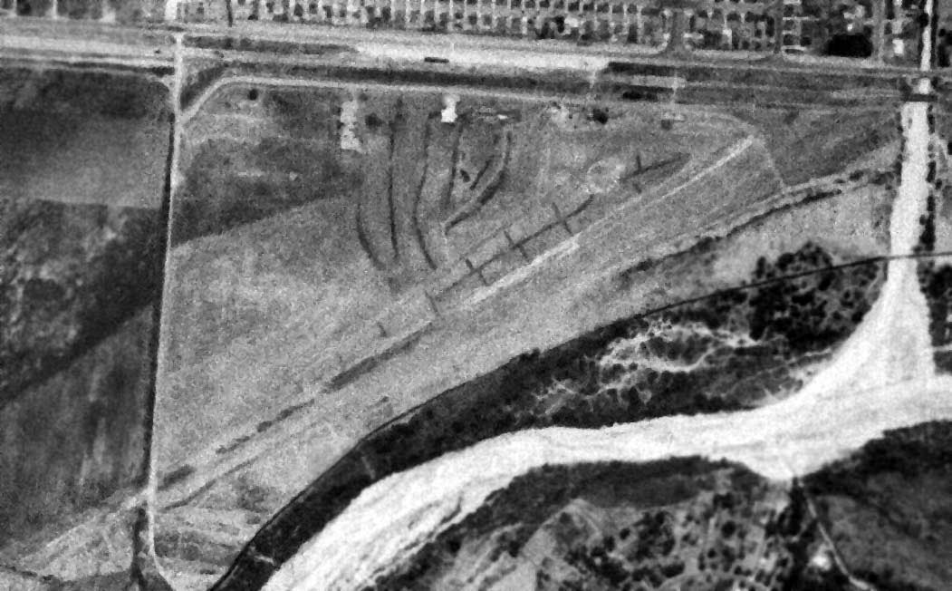
A 7/11/52 aerial view depicted a very different scene at Rosemead Airport compared to the earlier photos, with no aircraft visible on the field.
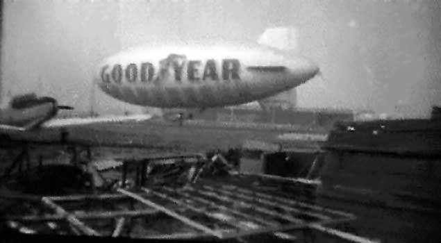
A 1952-53 photo by Ernie Duke of the Goodyear Blimp “Enterprise” at Rosemead Airport.
Lloyd Duke recalled, “He used a Browne Box Camera.
Note, that is not Termite Snider’s BT-13. I never did see this one fly or see the owners.
This picture was taken from the junk area next to the burned-down hanger to the west, toward Hardwick’s place.
Hardwick’s barn is nearly empty in this picture.”
According to Lloyd Duke, “After about 6 months at the Rosemead Airport the Goodyear operation moved over to Culver City where it is now.”
A 1953 aerial view showed a few small aircraft parked on the northeast side of the field.
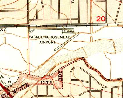
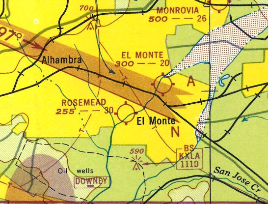
The 1953 USGS topo map depicted the “Pasadena-Rosemead Airport”
as having a paved northeast/southwest runway & a paved east/west taxiway, with 4 buildings along the north side.
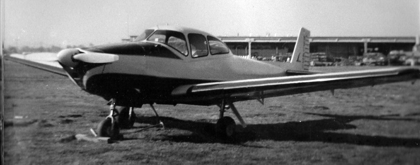
A 1953 photo (courtesy of Lloyd Duke) at Rosemead Airport which Lloyd Duke observed was of “the Naviony, a highly-modified Navion owned by Jimmy Thomas & given the name Naviony by Louie Lombardo.
It was based at Rosemead Airport from 1952-56; Jimmy used it as his executive aircraft.
He was the owner of Utility Metal Products in Pasadena. At the time he had a contract to build the wings for North American Aviation's F-100s.
Later Jimmy bought a D-18 Beachcraft for his Executive transport in about late 53. It was also based at Rosemead.
The Naviony was an Experimental aircraft. Jimmy installed an 0470L 260 horsepower engine & added new cowling to accommodate an augmenter cooling & exhaust system.
He added splitters to the wing leading edge & slots in the outer 4' of each wing.
The flaps were ticked down one degree, and the dorsal fin was enlarged. The horizontal stabilizer was ticked up one degree.
It was my job to keep it washed & waxed. For that I got to set in the right front seat & fly it to whereever we decided to have lunch.
Flights to San Diego, Santa Paula & a couple of times to Las Vegas. It flew like a homesick angel. Great times. In the background is Jack Hardwick's shed full of aircraft junk.
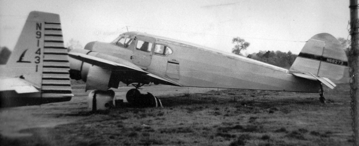
A 1953 photo (courtesy of Lloyd Duke) at Rosemead Airport which Lloyd Duke observed was of “Louie Lombardo's T-50 Bobcat. It was modified with two 300 horsepower Jacob engines.
This picture was taken after Louie’s round-trip flight from Rosemead to Rome Italy.
He took his wife & son on that trip. Its condition in this picture was being prepared for its annual inspection.
I had the same deal with Louie to keep the oil wiped off the bottom of the engines, wash and waxing.
Got lots of right-seat time in this old bird. The biggest problem was tapping the throttles to keep the engines in sync. Other than that it was a pleasure easy to fly.
One funny event in this plane: Jimmy was trying to teach his factory manager to fly the Bamboo Bomber.
I was just riding in the back seat & watching the antics of Jimmy & George the factory manager when I noticed that about on our 7th touch & go a California Highway Patrolman showed up at the gas pits.
On the 10th circuit he began waving us to come to him. I told Jimmy the CHP guy wanted to see us.
After the 11th circuit we landed & taxied up to the gas pit. The CHP guy said we were disturbing the peace by flying low over the Garvy Hills. An Old lady there had called the police.
For some reason George would not climb in a reasonable fashion to pattern altitude & liked to turn crosswind over the hills. Jimmy got a ticket for Disturbing the Peace.”
The September 1954 USAF LA Sectional Chart (courtesy of Chris Kennedy) depicted Fletcher Airport as having a 3,000' unpaved runway.
According to Bob Falcon, the Fletcher Aviation plant “was built in the early 1950s.
The building was one of the first in Los Angeles to have a seismographic roof.
The roof panels in that building are laced with 1.5 steel cable rope with treaded fittings bonded to the ends.
These are threaded into receptacles within the roof girders.
This design will cause the concrete panel to break up into small hunks rather than slamming down to the floor as a 10x10 foot slab of concrete.
The fist product manufactured in that building was the Fletcher FU-24,
a John Thorpe designed single-engine 6-place low-wing that was later redesigned as a crop duster & continues to be manufactured in New Zealand.
The Fixed Base Operator was located on the east end of the field.
The runway ran parallel to the wash & Telstar Avenue sort of follows the route.
Noel Roberts had his L-2 Taylorcraft parked there when the Heasley Brothers operated the Fixed Base Operation.
The Fletcher Plant building was first built with the main entrance located on the south side which was the airfield side.
The shipping department was located on the north side adjacent to a railroad siding.
When the freeway was completed through that portion of the San Gabriel Valley
and the siding was rendered inactive the main lobby was switched to the north face & Shipping was moved to the south.”
The 1955 San Diego Sectional Chart (courtesy of John Voss) depicted Fletcher Airprot as having a 3,000' unpaved runway.
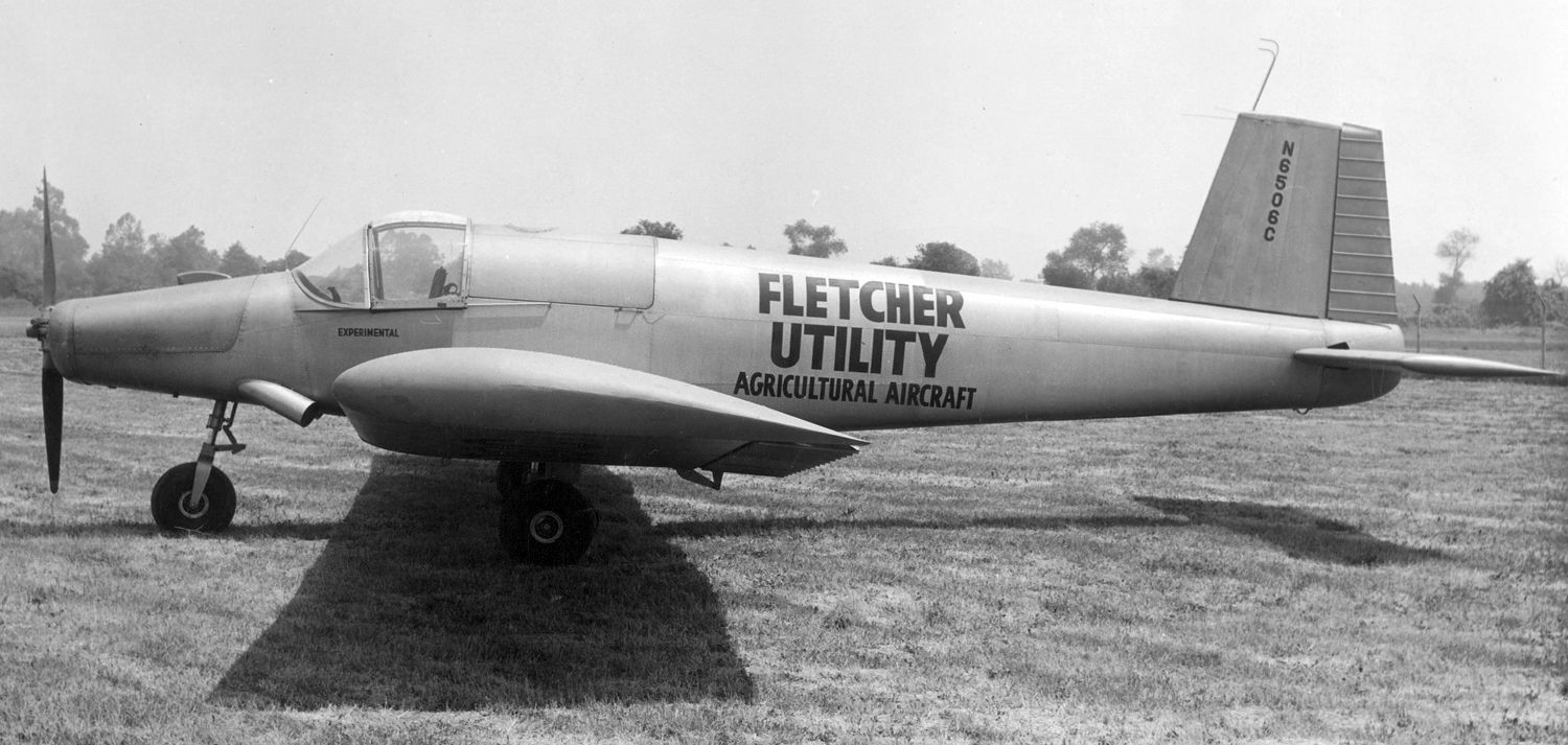
A circa 1955-56 photo of Fletcher FU-24 C/n 7 N6506C at Fletcher Airport.

The last aeronautical chart depiction which has been located of Fletcher Airport was on the 1960 LA Local Aeronautical Chart.
It depicted Fletcher as a private airfield having a 2,500' unpaved runway.
The last photo which has been located of Fletcher Airport was a 5/24/60 aerial view (from the UCSB Library).
It depicted Fletcher Airport as having a paved northeast/southwest runway & a paved east/west taxiway.
Two light single-engine aircraft were located within the Fletcher Aviation compound, along with the factory at the northwest corner,
and 3 other light aircraft were located further east near the small FBO buildings.
The 1962 AOPA Airport Directory described "Fletcher" Airport as having a single 2,500' turf Runway 4/22.
According to Richard Franklin, “The last plane to land & takeoff [at Fletcher Airport]
was probably a Fletcher Aircraft crop duster of which they built a few in the early days & then went strictly to fuel tanks.”
According to Bob Falcon, “The very last pilot to make a landing & takeoff [at Fletcher Airport] really was Dick Weis.”
Fletcher Airport was apparently closed at some point between 1962-64,
as it was no longer depicted at all on the August 1964 LA Local Aeronautical chart (courtesy of Donald Felton).
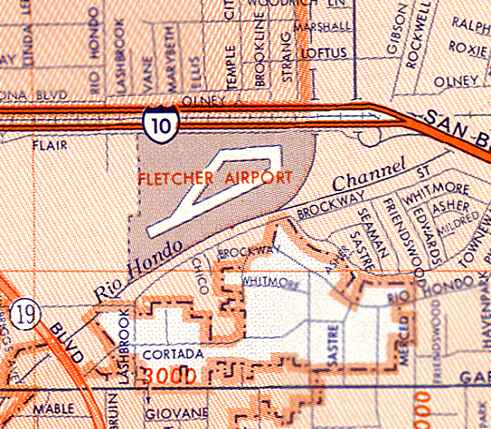
Fletcher Airport was still depicted (with a runway & 2 taxiways) on a 1967 street map,
but it had evidently already been closed for at least 3 years by that point.
According to Bob Falcon, “When Fletcher Aviation sold to AJ Industries in the 1960s,
AJ immediately sold the portion of the land from Rio Hondo Avenue almost to Rosemead Boulevard
to AeroJet Corporation & they built a large facility there.
It is named Flair Park & the roadway that parallels the I-10 Freeway is named Flair Drive.
Flair was the cable address for Fletcher Aviation!”
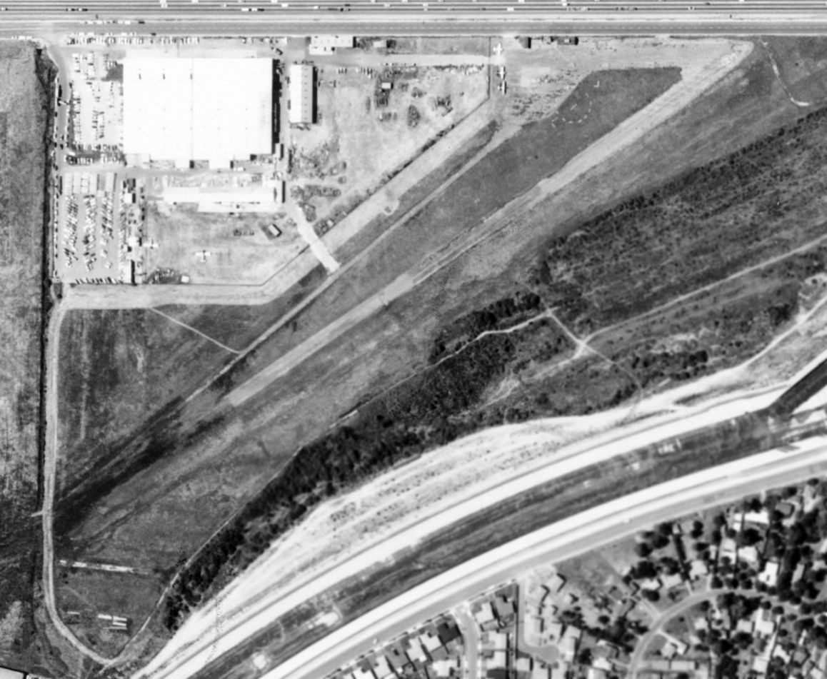
A 1972 aerial view showed that industrial buildings had covered the Fletcher Airport site, with not a trace remaining of the little airport.
As of 2006, the Sargent Fletcher company was still located at the site of Fletcher Airport.
Bob Falcon reported in 2006, “The Fletcher Aviation plant that was constructed in the early 1950s is the only one of the older buildings that exists.
It is still in operation today engaged in the design & manufacturing of aircraft external fuel tanks,
hose & drogue aerial refueling systems, special-purpose aircraft under-wing pods, and pneumatic bomb racks.”
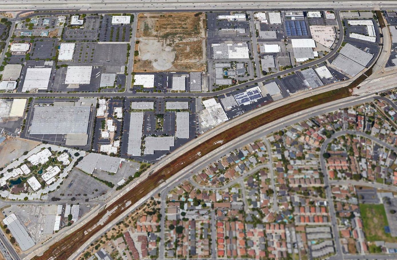
A 2017 aerial view looking north showed the Fletcher Airport site does not bear any recognizable traces as a former airport.
According to Dan MacPherson, the site of Rosemead Airport is currently bordered by the 10 Freeway on the north,
Rosemead Boulevard on the west, and the wash on the south.
See also: http://www.bannerbob.net/Rosemead.htm
____________________________________________________
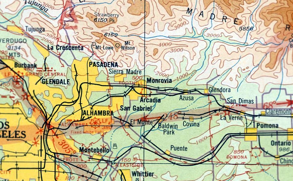
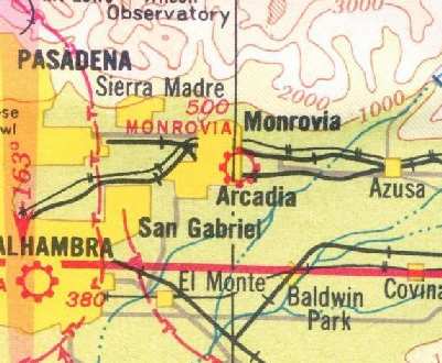
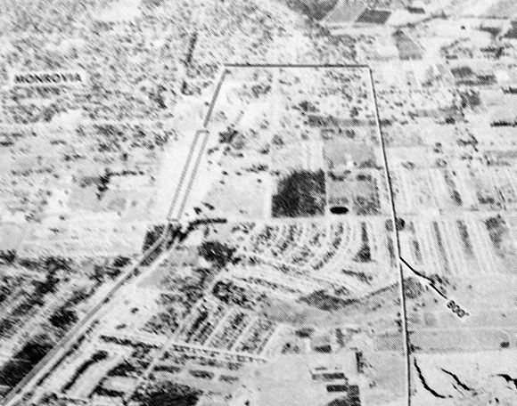
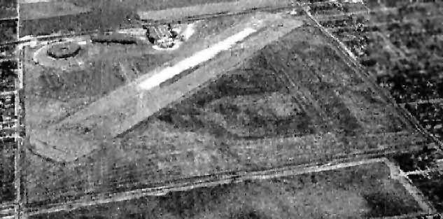
Foothill Flying Field / Monrovia Airport, Monrovia, CA
34.137, -117.99 (Northeast of El Monte Airport, CA)
Foothill Flying Field, as depicted on the August 1933 LA Sectional Aeronautical Chart.
According to the book “Monrovia Airport, Alias Foothill Flying Field” by John Irwin (courtesy of Hank Morris),
Don Robertson began looking for a place to establish an airport in June 1928,
and established the Monrovia Airport Club with other aviation-oriented citizens.
Robertson leased a natural landing field, and owned 2 planes & a hangar.
In November 1930 the Monrovia Field, alias Foothill Flying Field, was approved for commercial operations.
According to the book “Monrovia Airport, Alias Foothill Flying Field” by John Irwin (courtesy of Hank Morris),
by 1930 Don Robertson had a partner, Harold West.
On October 1932, Don Robertson announced that over 12,000 paying passengers had been flown off the field without a single accident.”
Foothill Flying Field was not yet depicted on the June 1932 LA Sectional Chart.
The earliest depiction which has been located of Foothill Flying Field was on the August 1933 LA Sectional Aeronautical Chart.
It depicted Foothill as a commercial/municipal airport.
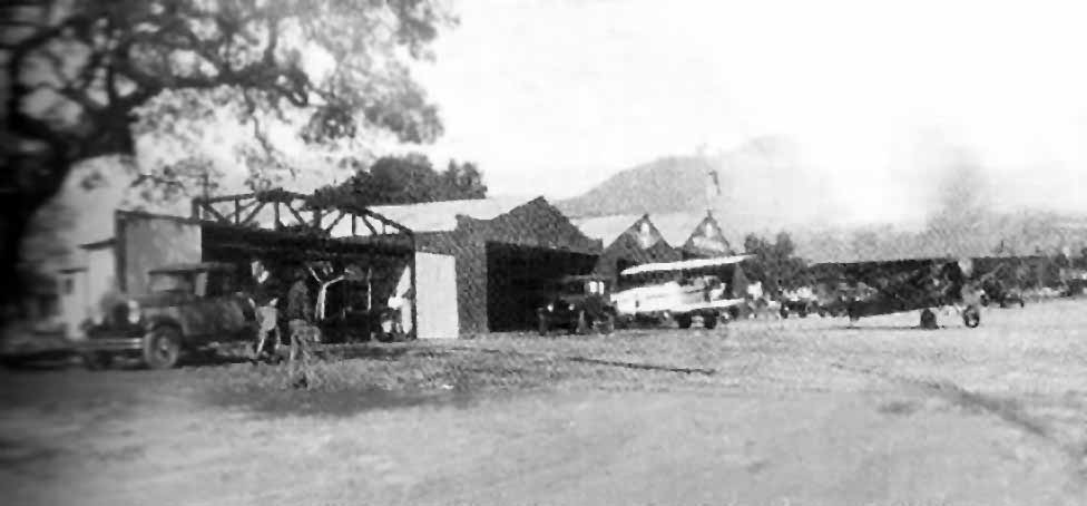
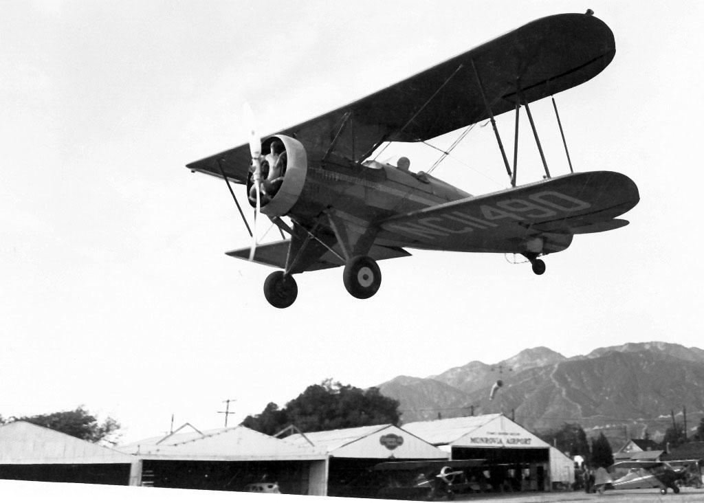
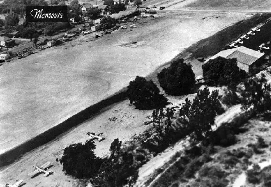
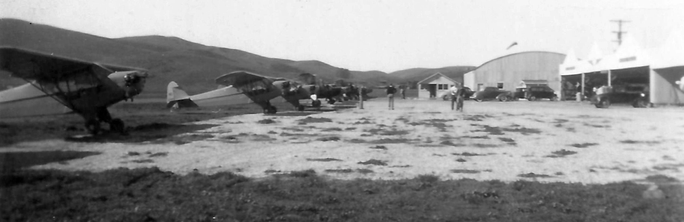
The earliest photo which has been located of Foothill Flying Field was a circa 1930s photo looking northwest
at a biplane & monoplane in front of the row of 4 hangars of Foothill Flying Field (courtesy of Hank Morris).
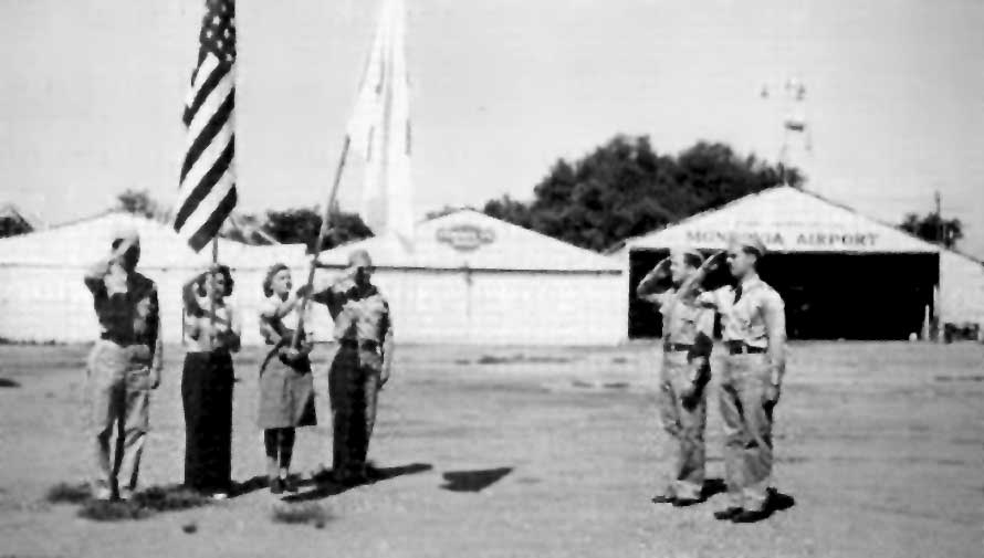
Monrovia Airport was known among pilots as "the friendliest little airport in the country."
According to John Hazlet, Monrovia Airport was frequented by such Southern CA aviation legends
as the Riley Brothers, TWA Captain & former airshow pilot Kalman Irwin,
and Pancho Barnes (of the "Barnes Happy Bottom Riding Club").
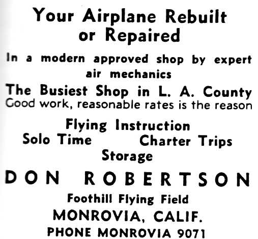
A circa 1930s advertisement for Foothill Field Field (courtesy of Hank Morris).
According to the book “Monrovia Airport, Alias Foothill Flying Field” by John Irwin (courtesy of Hank Morris),
“Hoyet Cabe was the airport manager for Don, but Hoyet died very young & Don gave up the Foothill Flying Field shortly thereafter.
Don was a heavy drinker, and by 1934-35 was behind in his lease payments, with the bank ready to take over.
Wymann Ellis & Dan Moran took over & became the new operators.
Dan Moran flew the 1st airmail flight from Monrovia on 5/19/38.
Al Blackburn took over the airport from Ellis & Moran.
Several movie firms were located in Monrovia,
and parts of 4 movies were filmed at the airport, starting with 1935's “The Fighting Pilot”.
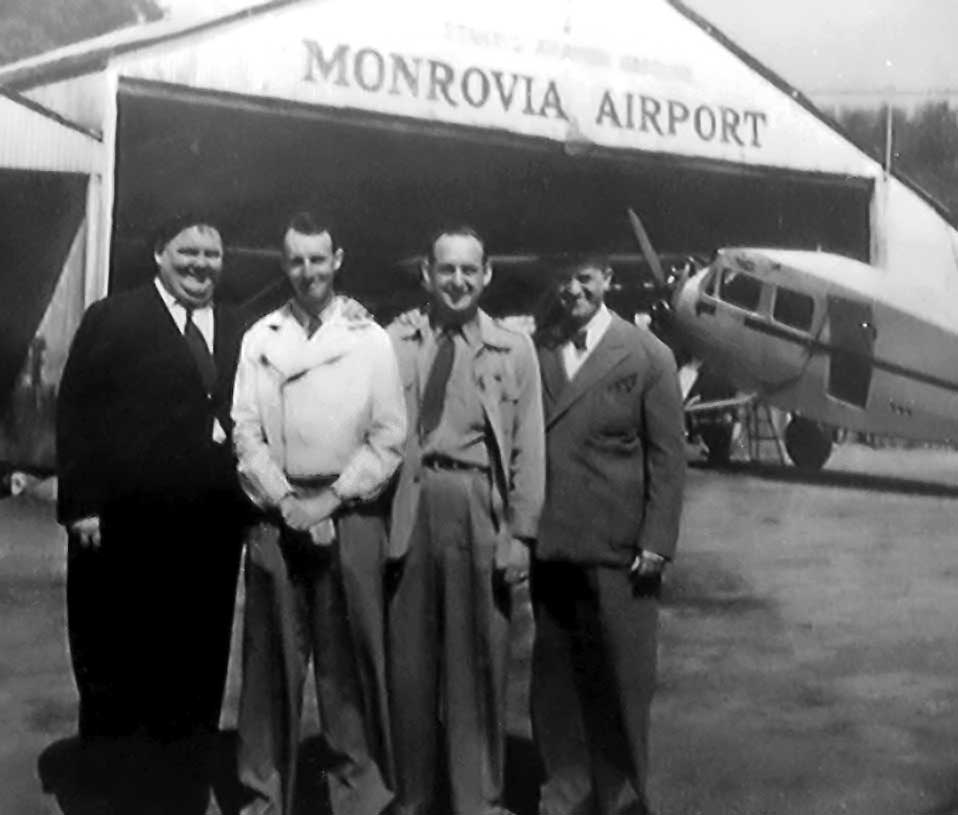
A circa 1930s photo taken at Monrovia Airport in the 1930s when Laurel & Hardy were filming there (from the collection of Tom Blackburn, courtesy of Steve Sharpe).
Steve observed, “Al Blackburn is next to Oliver Hardy, not sure who the other chap is.”
The earliest directory listing which has been located for Monrovia Airport
was in The Airport Directory Company's 1937 Airports Directory (courtesy of Bob Rambo).
It described Monrovia Airport as having a single 2,700' sand northeast/southwest runway & a hangar.
An interesting sidebar to the Monrovia Airport story concerns an adjacent business.
In 1937, the MacDonald brothers borrowed some lumber
and built a tiny octagonal restaurant building on Huntington Avenue.
Due to their proximity to the Monrovia Airport, they informally referred to their little restaurant as the "Airdrome".
This was the very first restaurant in the MacDonalds' fast food empire!
The original octagonal building was later moved to San Bernardino.
According to Scott Rolf, “My dad learned to fly at the age of 16 from the Monrovia Airport (formally Foothill Airfield) in 1938.”
The 1939 LA Sectional Aeronautical Chart (courtesy of Jon Karkow) depicted Monrovia as a commercial/municipal airport.
The 1939 LA County Airports Map depicted Monrovia as having a single north/south runway.
A beautiful 1939-40 photo of a 1931 Waco F-2 biplane (possibly being flown by Donald Rolf) overflying the row of hangars Monrovia Airport (courtesy of Scott Rolf).
According to Scott Rolf, “The plane was owned by the airport at the time, probably under Al Blackburn.”
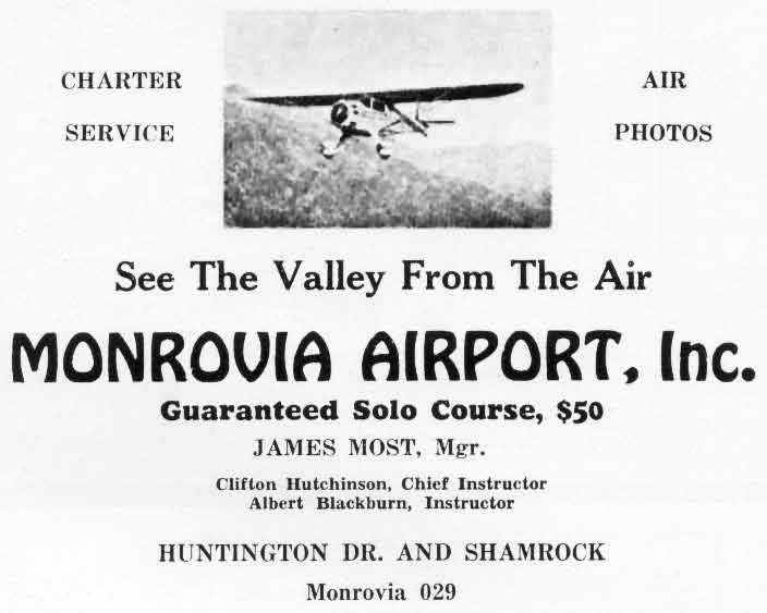
An undated advertisement for Monrovia Airport (courtesy of Dan MacPherson).
According to the book “Monrovia Airport, Alias Foothill Flying Field” by John Irwin (courtesy of Hank Morris),
the movie “The Great Plane Robbery” was filmed at Monrovia Airport in 1940.
Hank Morris recalled, "As a small boy I remember when virtually every Sunday there was a parachute jump at Monrovia.
Also, it was the location for filming the 1939 movie '20,000 Men a Year', starring Randolf Scott.
I remember watching some of the filming, including some purposeful crashes."
A 1942 photo of Monrovia's Civil Air Patrol in front of the hangars of Monrovia Airport (courtesy Betty Irwin, from a book by John Irwin).
A circa early 1940s photo of a biplane & Porterfield CP65s in front of 4 hangars at Monrovia Airport (courtesy Betty Irwin, from a book by John Irwin).
A 7/21/43 aerial view looking west at Monrovia Airport from the 1945 AAF Airfield Directory (courtesy of Scott Murdock)
depicted the field as having a single unpaved north/south runway.
According to the book “Monrovia Airport, Alias Foothill Flying Field” by John Irwin (courtesy of Hank Morris),
the movie “The Big Noise” was filmed at Monrovia Airport in 1944.
The 1945 AAF Airfield Directory (courtesy of Scott Murdock) described Monrovia Airport
as a 35 acre rectangular field within which was a single 2,700' gravel north/south runway.
The field was said to have a total of 7 metal hangars, with the largest being a 100' square structure.
Monrovia Airport was described as being privately owned & operated.
The 1946 LA Local Aeronautical Chart (courtesy of Tim Zukas) depicted Monrovia Airport as having a 2,600' unpaved runway.
A 1947 aerial photo of Monrovia Airport by Don Downie, courtesy of Dan MacPherson.
A 1947 article in Flying Magazine described Monrovia Airport as having
"a 2,600' gravel runway, a snack bar, and 50 planes which are tied down for the fairly standard rate of $15."
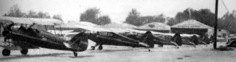
A 1948 aerial photo depicted dozens of light aircraft at Monrovia Airport.
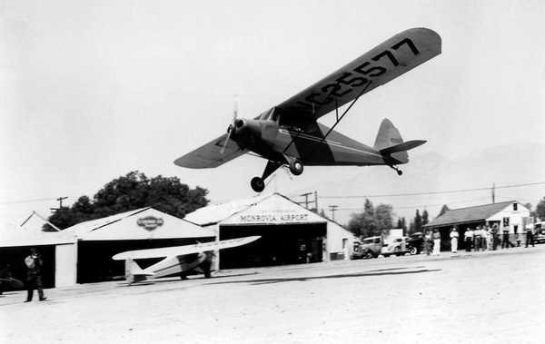
A circa 1940s photo of a Porterfield taking off or landing at Monrovia Airport.
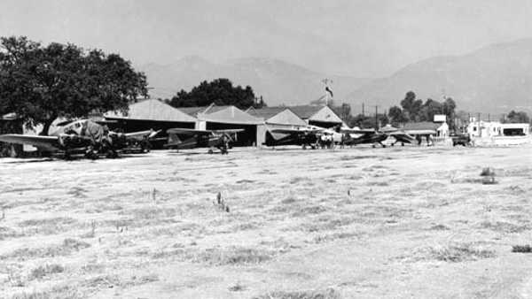
A circa 1940s photo of a row of planes (including one twin-engine plane) in front of 4 hangars at Monrovia Airport.
An undated advertisement in a Monrovia City Directory listed the operator of the airport as Monrovia Airport Inc., King Williams, President.
The business listed at the airport were Monrovia Aircraft Repair, Reliance Flight Academy, and Riley Flying Service.
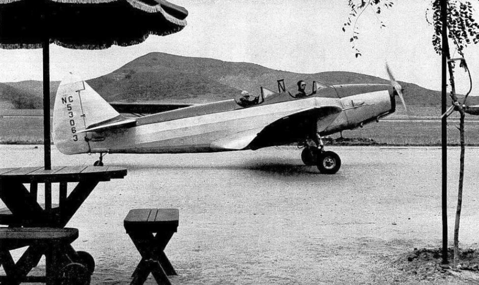
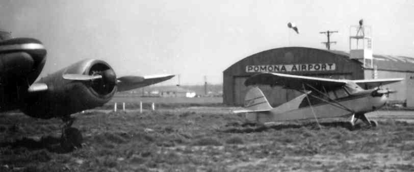
A circa 1940s photo by George Keens of his Ryan PT-22 at Monrovia Airport (or possibly Pomona Airport) (courtesy of David Keens).
David Keens recalled, “My father purchased the plane shortly after WWII from war surplus airplanes in Hemet, CA.
He hand-polished the body & painted a personal color scheme including a family crest he designed himself.
He was quite proud of his plane, and flew it regularly around Southern California.”
The last photo which has been located showing Monrovia Airport while it was still operational was an undated aerial view looking north from the 1950 Air Photo Guide (courtesy of Kevin Walsh).
The guide described Monrovia Airport as having a 2,600' paved Runway 17/35, and listed the manager as King Williams.
A circa 1952 photo of George Keens & his Luscombe at Monrovia Airport (or possibly Pomona Airport) (courtesy of David Keens).
David Keens recalled, “He purchased this plane after my brother & I were born, replacing the Ryan PT-22 with this more 'family' plane.”
According to the book “Monrovia Airport, Alias Foothill Flying Field” by John Irwin (courtesy of Hank Morris),
land values increased so much in the 1950s that Al Blackburn & his partners sold the airport property
on 2/26/52 to Consolidated Engineering Corporation, who intended to redevelop the land, but they allowed Monrovia Airport to continue to operate for a short while.
The last aeronautical chart depiction which has been located of Monrovia Airport was on the March 1952 LA Sectional Chart,
which depicted Monrovia as having a 2,600' unpaved runway.
Monrovia Airport was no longer depicted on the September 1952 LA Sectional Chart.
According to the book “Monrovia Airport, Alias Foothill Flying Field” by John Irwin (courtesy of Hank Morris),
Consolidated Engineering Corporation allowed Monrovia Airport to operate until 1953.

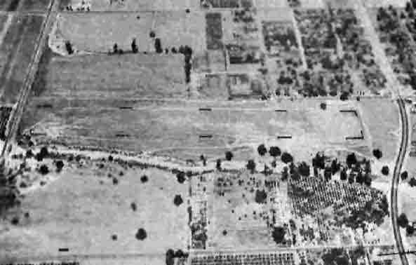
A 7/10/52 USGS aerial view appeared to show Monrovia Airport after it had closed,
as there were no aircraft on the field, in contrast to previous pictures.
The airport buildings otherwise appeared to remain intact.
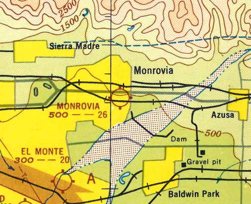
As depicted on the above 1953 Pocket Atlas (courtesy of Dan MacPherson),
Monrovia Airport was situated southeast of the intersection of Huntington Drive & Shamrock Avenue.
The 1953 USGS topo map no longer depicted Monrovia Airport.
A 1953-54 aerial view (courtesy of Hank Morris) showed that all of the hangars & buildings had been removed,
with the airport property scraped clean in preparation for redevelopment.
Monrovia Airport was no longer depicted at all on the 1957 LA Sectional Chart.
Hank Morris recalled, “Even after the airport closed, a small spot in the northeast corner was a heliport for LA Airways with service to LAX.
I used the Monrovia spot to get to/from LAX. They flew S-61 & S-62 helos.
They ultimately went belly-up. In those days... 1950s, early 1960s... using the helo initially added nothing to the airline ticket, but later it added about $5 each way.
Helos are load sensitive, passengers were weighed on a bathroom scale provided by the taxi service. No station agent!
I recall one trip from Monrovia where we waited for one passenger & he must have weighed 300 lbs & we were almost at the limit.
He was weighed his bags were not... and the clipboard with weights was handed to me by the taxi driver & I passed it up to the pilot.
Shortly he passed it back down with 'revised' weights & I gave it to the taxi driver to allow man & his unweighed baggage... to board.
We also had a sack of mail in the cabin... not unusual... and we made a stop at Alhambra where I dumped off one mail bag & received another. What an operation!”
Bob Cannon recalled, "In the 1960s I worked right across the street from Monrovia
and you could still see the remains of the end of the runway & taxiways
where the company situated there was using the tarmac for auto parking."
A 1972 aerial view did not show any recognizable trace of Monrovia Airport.
Keith Wood recalled, "In 1973-74, the site was obviously no-longer an airport, as visible from the street.
I rode past it on my bicycle several times, and knew there was an airport behind that rusty, locked gate, but not which one until later."
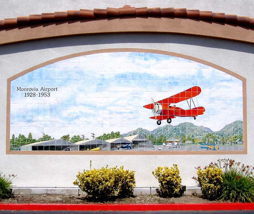
A 4/18/08 photo of a mural on Albertson's Market on Huntington which commemorates the site of Monrovia Airport.
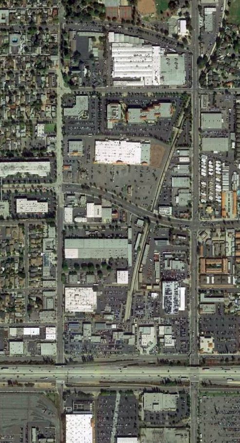
A 2016 aerial view showed the site of Monrovia Airport is now a densely populated area.
The 210 Freeway now bisects the south end of the airport site.
The site of Monrovia Airport is bounded by Cypress Road on the north, Shamrock on the west,
Sawpit Wash on the east, and Duarte Road on the south.
____________________________________________________
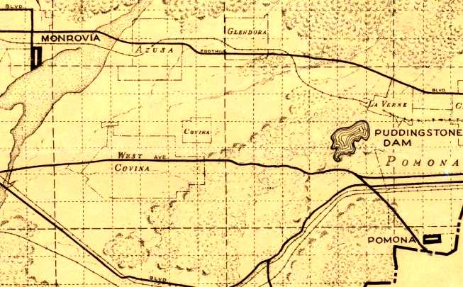
Puente Sky Ranch / Zephyr Skyranch, La Puente, CA
34.012, -117.932 (East of Los Angeles, CA)
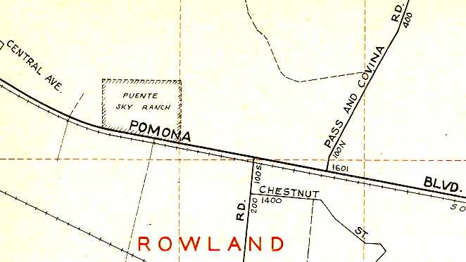
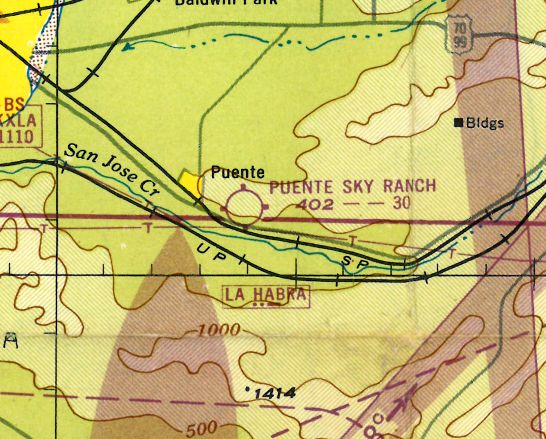
Puente "Skyranch", as depicted on the February 1946 LA Sectional Aeronautical Chart (courtesy of Dan MacPherson).
The date of establishment of this small airport has not been determined.
Puente Sky Ranch was not yet depicted on the 1939/41/44/45 LA Sectional Charts.
According to Lane Leonard, “During WW2 the Puente Airport was used as an auxiliary & training field for the Cal Aero cadets & was known for its crosswinds.
Later it was called the La Puente Airport.
The name was changed from the Basque Puente to La Puente as Hispanic population increased & the Basque lessened.”
The earliest depiction of Puente Sky Ranch which has been located
was on the February 1946 LA Sectional Aeronautical Chart (courtesy of Dan MacPherson).
According to Dan MacPherson, "I bought some ancient Piper log books at a swap meet. The books were from Sky Ranch.
I traced the planes (Cubs) to the owner, a French man named Etienne Noir."
Later, one of the museum guys surprised me by asking if I knew anything
about a place called Sky Ranch owned by a guy with that name."
The Airport was on the north side of Valley Blvd.
The entrance to the airport was across the street from Anaheim Puente Road, which is still there."
A 1946 photo by Harry Gordon of flight instructor Ray Hilton in front of several planes at Sky Ranch in 1946.
According to Harry, that he & many of his CAP Cadet friends flew with Ray.
Harry recalled, “The other instructor I remember from Sky Ranch was Art Soare.”
Harry Gordon recalled, “Sky Ranch... The airport had a decomposed granite runway in an alfalfa field.
It was a friendly & neat place with a recreation room where we could play ping-pong.
My Civil Air Patrol Cadet squadron was given reduced rates so we could fly Cubs for $5/hour
(the standard rate at most airports in the post-war years was $8/hour solo, $11/hour dual).
The brother of one of the Cadets had an old bus that we used for the weekend trips to Sky Ranch from southwest Los Angeles.
The Cadets would camp out Saturday night on a little mesa.”
The 1946 Thomas Brothers Map of LA (courtesy of Dan MacPherson)
depicted “Puente Sky Ranch” Airport as a rectangular property located along Pomona Boulevard.
John Slais recalled, "I learned to fly there [Puente Sky Ranch Airport] beginning in 1946
when I was a line boy working 6-10 hour days a week for $20 & 1 hour in an Interstate Cadet.
My instructor was Howard Riley & I thought he managed the field but may be mistaken. I soloed 11/4/48 on my 16th birthday.
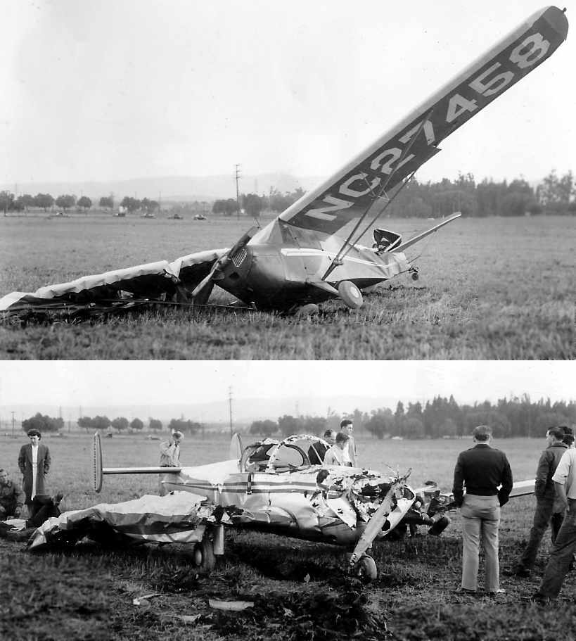
The biggest plane on the field was a Vultee BT-15 (like a BT-13 with a Wright engine) which later crashed close by killing both occupants.
I remember the flight office, a diner and a hangar. I went away in the military service & that's the last I saw of Sky Ranch."
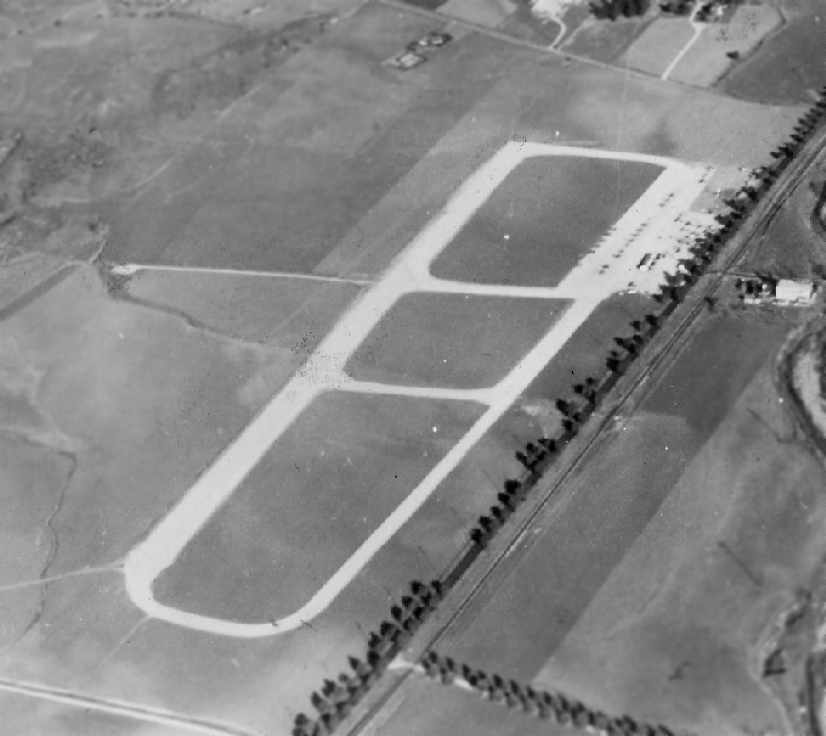
A circa late 1940s aerial photo looking northeast at Puente Sky Ranch (courtesy of Mal Soare via Dan MacPherson).
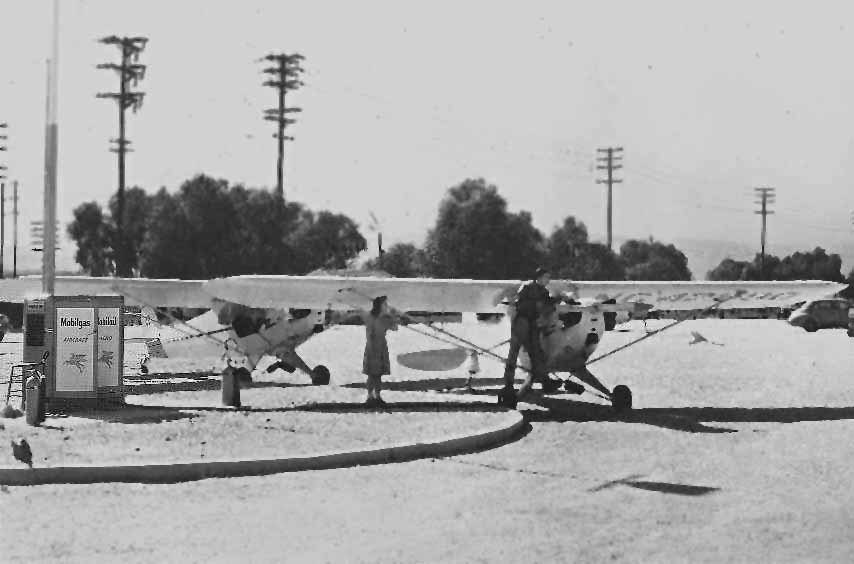
A circa late 1940s photo of the gas pumps at Puente Sky Ranch (courtesy of Mal Soare via Dan MacPherson).
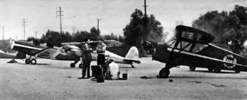
A lineup of planes on the Sky Ranch ramp, from a March 1946 article (courtesy of Dan MacPherson).
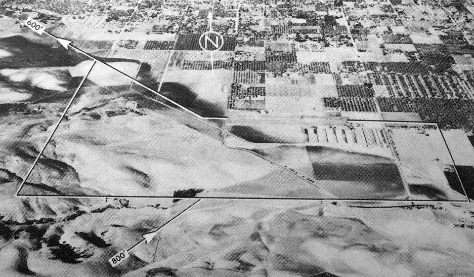
As seen in an aerial photo from a March 1946 article (courtesy of Dan MacPherson),
Puente Sky Ranch had a single runway (oriented west-northwest/east-southeast), along with a parallel taxiway.
The runway was described as being a 3,000' "rolled-granite all-weather" strip.
There were a total of 4 buildings on the field, including an administrative building & a "recreation" building.
The general manager was listed as Etienne Noir ("known as Steve around the Sky Ranch"),
who was also said to operate another flying school at Rosemead Airport.
Sky Ranch had a staff of 12, including a chief pilot aptly named Art Soare.
Six Piper Cubs were available for rent, for the meager rate of $7/hour.
An aerial view looking southeast at Sky Ranch, from a March 1946 article (courtesy of Phil Brooks).
A surplus Fairchild PT-19 at Sky Ranch, from a March 1946 article (courtesy of Phil Brooks).
Chief Pilot Art Soare instructing a pilot at Sky Ranch, from a March 1946 article (courtesy of Phil Brooks).
The area north of the runway had been staked out for a residential subdivision, to be built by Etienne Noir.
Noir described great plans for the future of his little airport.
The Sky Ranch airport was said to represent a total investment of $117,000 - quite a princely sum for 1946!
An article in the 8/9/46 Covina Argus (courtesy of Richard Graham)
noted that Etienne Noir, President of the Skyranch Corporation, intended to “wind up its affairs & voluntarily dissolve.”
Two circa late 1940s photos of a mid-air collision between a Piper & an Ercoupe,
which occurred in the Puente traffic pattern (courtesy of Mal Soare, via Dan MacPherson).
According to Mal Soare, all occupants in both airplanes survived.
The 1947 LA Local Aeronautical Chart (courtesy of Tim Zukas) depicted Puente Sky Ranch as having a 3,000' unpaved runway.
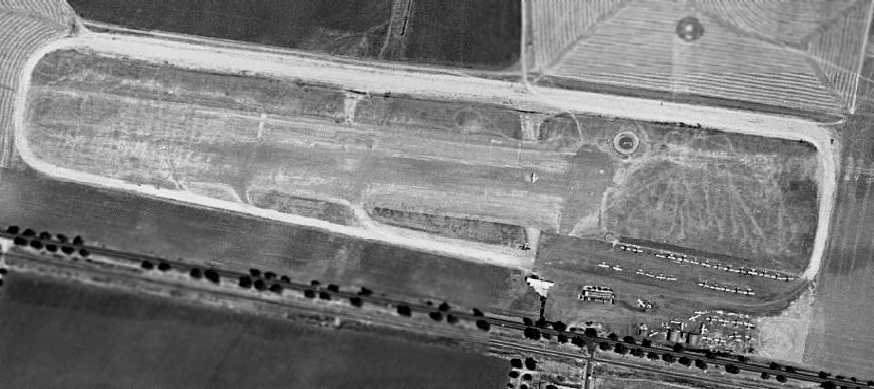
A 1948 aerial view of Puente Sky Ranch depicted the field as having a single east/west runway with a parallel taxiway.
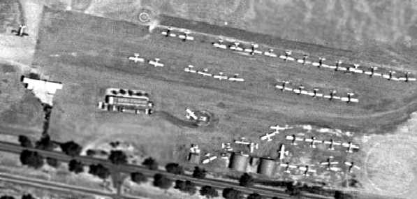
A closeup from the 1948 aerial view of the hangars & large number of single-engine aircraft at Puente Sky Ranch.
Harry Gordon recalled, “The last time I landed at Sky Ranch was in April 1949.”
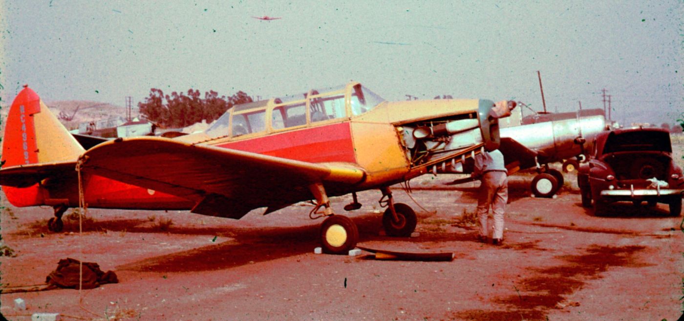
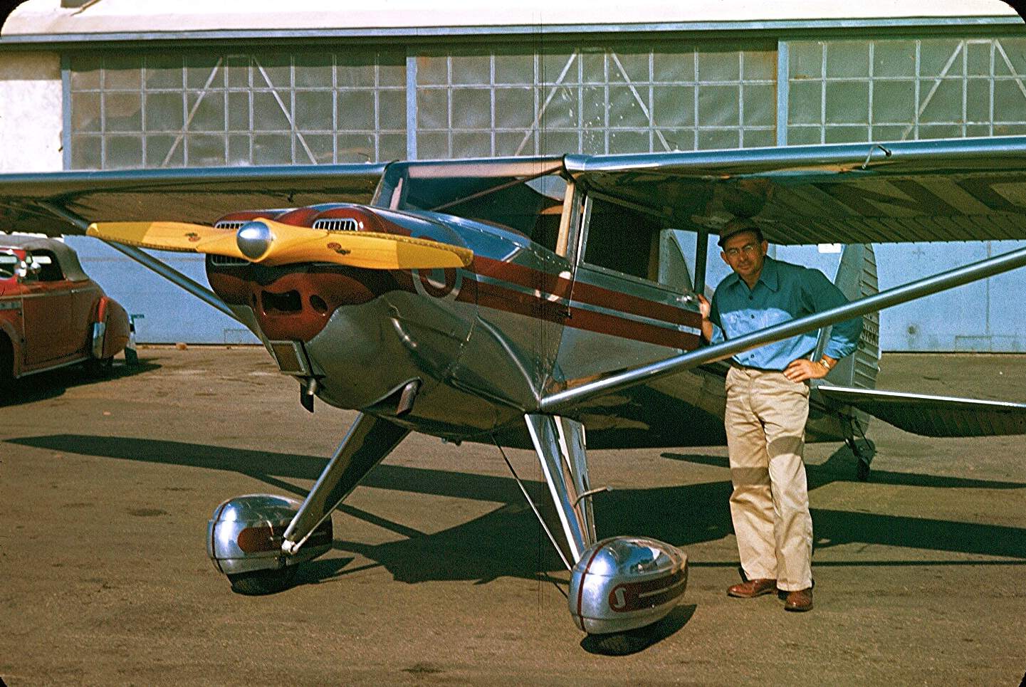
A circa 1950 photo by Fred Fahrner (courtesy of Steve Fahrner) of Ted Fahrner working on the engine of his PT-26 (NC49697) which he based at Puente Sky Ranch.
Steve recalled, “My Grandfather [Fred] was a passionate amateur photographer, and began taking color photos in the late 1940s.”
A circa 1950 photo by Fred Fahrner (courtesy of Steve Fahrner) of a row of Fairchild PT-26s & a Vultee BT-13 at Puente Sky Ranch.
Steve recalled, “The young boy in front of the airplane is my brother David.”
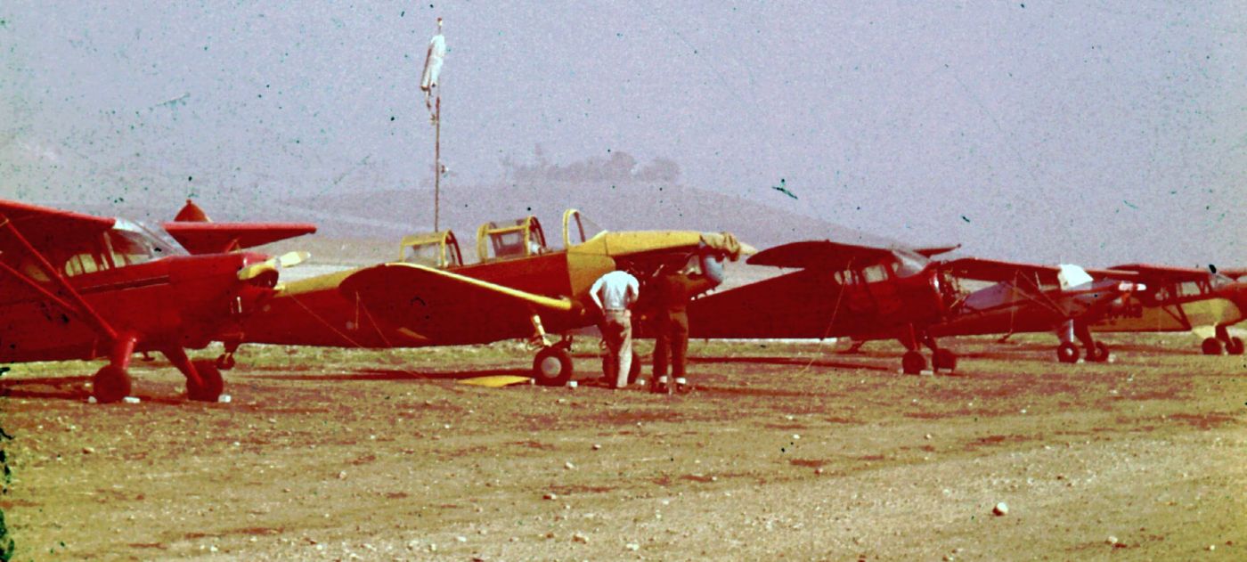
A circa 1950 photo by Fred Fahrner (courtesy of Steve Fahrner) of a variety of single-engine taildraggers at Puente Sky Ranch.
A circa 1950 photo by Fred Fahrner (courtesy of Steve Fahrner) of 3 Vultee BT-13s at Puente Sky Ranch.
The last aeronautical chart depiction which has been located of Sky Ranch was on the September 1950 LA Sectional Chart.
It depicted it as “Zephyr Skyranch”, perhaps an indication of change of management or ownership of the airport in its last days.
According to Lane Leonard, “When my father was furloughed at American in the early 1950s he instructed there.
I remember my first light aircraft flight was there in a Cub.”
According to Dan MacPherson, "Later [Sky Ranch owner Etienne Noir] developed the area himself -
I believe it was still called the Skyranch, except it was covered with contemporary (1949) dwellings."
Sky Ranch was evidently closed at some point between 1950-51, as it was no longer depicted on the March 1951 LA Sectional Chart.
A 7/11/52 USGS aerial photo of Puente was a stark contrast to the popular airport depicted in the 1948 photo.
The runway & hangars remained intact, but the field was sadly devoid of any aircraft.
Harry Gordon recalled, “I don't know just when the field was closed.
I later drove by to find the airport was gone, and billboards were advertising homes for sale in Sky Ranch Village.”
Arthur Carrillo recalled of Puente Sky Ranch, “I remember going there in the company of my father,
whose friend was running the diner on the site of the former airport.
The year was 1952-1953. My father, Jose Palacios Carrillo, worked with a man named Ray Pfau.
Ray lived in Puente also, on a lot large enough to have a barn & a horse.
For whatever reason, Ray Pfau wound up cooking/managing the diner, which was signed as the 'Sky Ranch Cafe'.
There was no aviation traffic that I can recall; but the diner was in operation.
On grounds surrounding the cafe, there was a shell of an old plane, and I remember crawling up & around & into it.
Whenever I have occasion to pass by or near the location of the old Sky Ranch Cafe,
many memories of simpler days bring a smile to my face.”
The 1953 USGS topo map no longer depicted Puente Sky Ranch.
A 1954 aerial photo showed that streets & houses had begun to cover the western half of the runway,
but 2 hangars remained standing on the southeast side of the property.

A 1954 road map (courtesy of Dan MacPherson) shows that the Puente Sky Ranch site had been crossed by a new street (Grassy Lane).
By the time of a 1965 aerial photo, the site of Puente Sky Ranch had been densely redeveloped with housing,
and not a trace appeared to remain of the former airport.
A March 2004 USGS aerial photo showed not a trace appeared to remain of Puente Sky Ranch.
The site of Puente Sky Ranch is located north of Valley Road, west of Azusa Avenue.
Keith Wood observed that “None of the streets in the neighborhood make any reference to the airport or aircraft,
which is strange if the developer was the airport owner.
However, the street names in that tract are people's last names, so perhaps they are honoring pilots or other airport folks.”
____________________________________________________
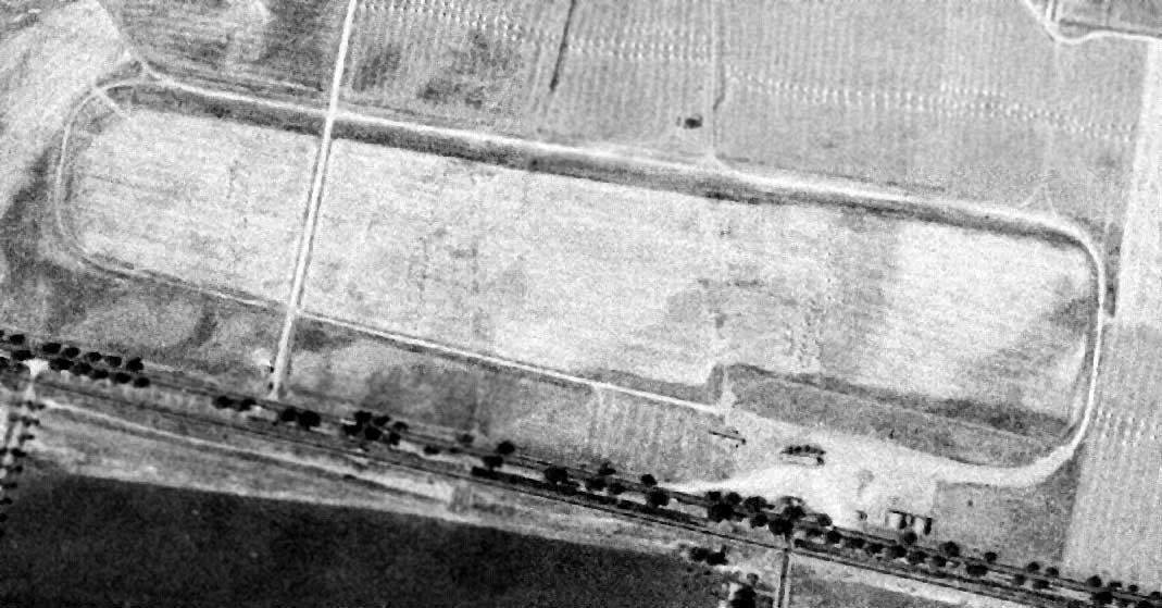
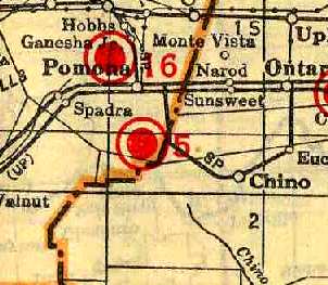
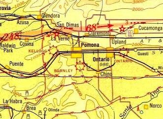
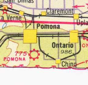
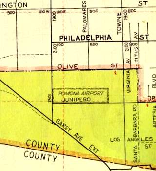
Burnley Airport / Pomona Airport, Pomona, CA
34.027, -117.745 (East of Los Angeles, CA)
Burnley Airport, as depicted on the 1929 "Rand McNally Standard Map of CA With Air Trails" (courtesy of Chris Kennedy).
Burnley Airport was dedicated in 1928, just 2 weeks after the opening of the nearby Kellogg Airport.
It occupied 20 acres on Garey Avenue south of the Pomona city limits.
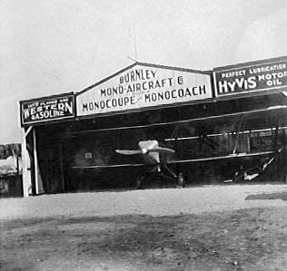
The airport & its flying school were operated by John Burnley & August Clancy.
The 1929 "Rand McNally Standard Map of CA With Air Trails" (courtesy of Chris Kennedy)
described Burnley Airport as being operated by J. Burnley, and being 1,500' x 700' in size.
An undated photo of Burnley Airport.
The earliest aeronautical chart depiction which has been located of Burnley Airport was on the 1932 LA Sectional Chart (courtesy of Scott O'Donnell).
It depicted Burnley as a commercial/municipal airport.
It was renamed Pomona Airport at some point between 1932-34,
as that is how it was labeled on the 1934 San Diego Sectional Aeronautical Chart (courtesy of Scott O'Donnell).
Pomona Airport, as depicted on the 1939 LA Sectional Chart (courtesy of Jon Karkow).
The 1939 LA County Airports Map depicted Pomona as having a single east/west runway.
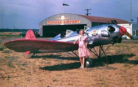
A pretty 1945 photo by George Keens of his wife Bess & their Ryan PT-22 in front of a Pomona Airport hangar (courtesy of Dennis Lord).
David Keens recalled, “My father purchased the plane shortly after WWII from war surplus airplanes in Hemet, CA.
He hand-polished the body & painted a personal color scheme including a family crest he designed himself.
He was quite proud of his plane, and flew it regularly around Southern California.”
Dennis Lord reported, “Aircraft ID is NC48997 which is still an active number today [2010].
Indeed, the aircraft is no longer assembled but I have located it in a hangar at Compton Airport although the current owner will not permit access.”
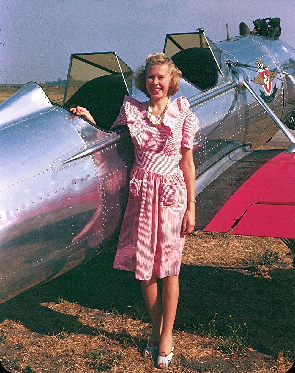
Another 1945 photo by George Keens of his wife Bess & their Ryan PT-22 at Pomona Airport (courtesy of David Keens).
The 1945 Haire Publishing Company Airport Directory (courtesy of Chris Kennedy)
described Pomona Airport as a "Class 1" airport, owned & managed by T. T. Clarke.
It was said to consist of a single 2,000' oiled east/west runway, along with a 90' x 60' hangar.
A pre-1946 photo of the a Cessna T-50 & an Aeronca in front of Pomona Airport's hangar (courtesy of Mal Soare, via Dan MacPherson).
Mal Soare recalled, “The T-50 is one of 4 that my dad [Art Soare] operated in Pomona using them for GI multi-engine training.”
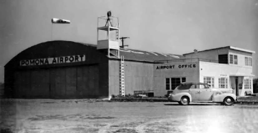
A pre-1946 photo of the Pomona Airport hangar & office (courtesy of Mal Soare, via Dan MacPherson).
The 1947 LA Local Aeronautical Chart depicted Pomona Airport as having a 2,000' unpaved runway.
The movie "Blaze of Noon" (starring William Holden) was filmed at Pomona Airport in 1947.
A 1948 aerial view of Pomona Airport depicted the field as having a single east/west runway,
with a hangar & over a dozen light aircraft on the northwest side of the field.
An undated photo of several men in front of a hangar at Pomona Airport (courtesy of Gary Holden).
According to Gary Holden, the picture was “probably taken close to the time the field was closing. Virgil Holden [4th from left] was my Dad.”
An undated photo of 2 Piper Cubs & several biplanes in front of hangars at Pomona Airport (courtesy of Gary Holden).
According to Gary Holden, the picture was “probably taken close to the time the field was closing.”
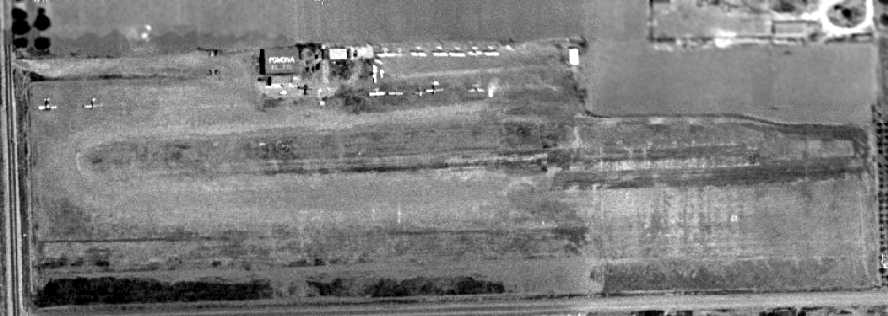
The last photo which is available of Pomona Airport was an undated aerial view looking north from the 1950 Air Photo Guide (courtesy of Kevin Walsh).
The guide described Pomona Airport as having a 1,920' dirt east/west runway, and listed the managers as Arthur Soare & James Wattenbarger.
Pomona Airport was closed in 1950, according to Bob Cannon.
The last aeronautical chart depiction which has been located of Pomona Airport was on the March 1952 LA Sectional Chart,
which depicted Pomona Airport as having a 1,900' unpaved runway.
Pomona Airport was evidently closed some point in 1952, as it was no longer depicted on the September 1952 LA Sectional Chart.
The 1953 USGS topo map no longer depicted Pomona Airport.
A 1954 street map (courtesy of Dan MacPherson) depicted the Pomona Airport property
as consisting of a very small rectangular plot, measuring only 2,000' east/west by 500' north/south.
A 1959 aerial photo showed that the site of the runway had been scraped clean,
and only the foundations remained of the Pomona hangars.
By the time of a 1965 aerial photo, the site of Pomona Airport had been densely redeveloped with housing & a school,
and not a trace appeared to remain of the former airport.
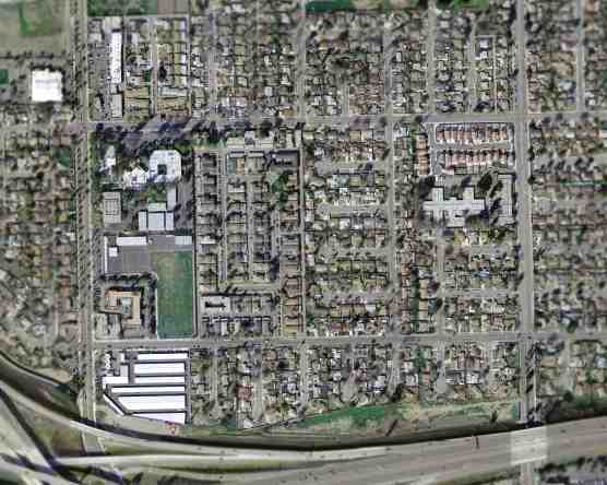
As seen in the March 2004 USGS aerial photo, the Pomona Airport site has been extensively redeveloped with housing,
and not a trace appeared to remain of the former airport.
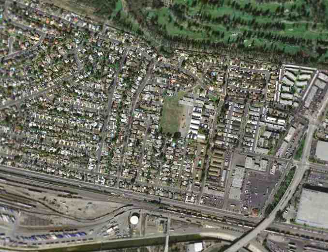
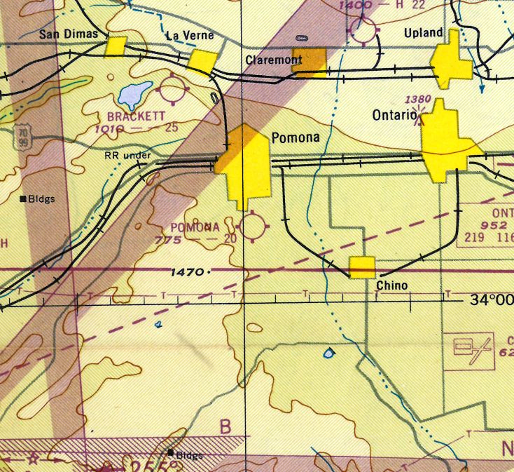
The site of Pomona Airport is located northeast of the intersection of Garey Avenue & County Road (known as Junipero Drive on the above 1954 map).
____________________________________________________
34.014, -118.054 (Northeast of Downtown Los Angeles, CA)
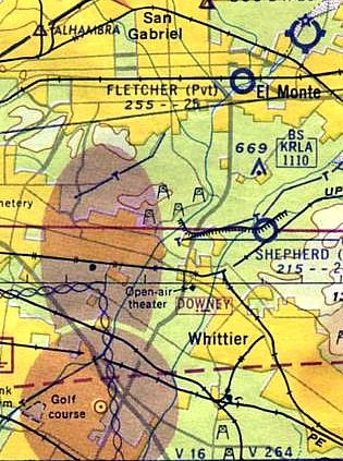
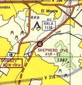
Shepherd Field, as depicted on the 1960 LA Local Aeronautical Chart.
Photo of the airfield while in use has not been located.
This little private airfield is located in the middle of the densely populated Los Angles metropolitan area.
It was evidently built at some point after 1953, as it was not yet depicted on a 1953 aerial photo.
Lloyd Duke recalled, “In 1954ish Shepherd built his own landing strip in back of his Caterpillar dealer grounds, in North Whittier, adjacent to Rose Hills Cemetery.”
Shepherd Field was not yet depicted on the 1958 LA Sectional Chart (according to Chris Kennedy).
The earliest depiction of Shepherd Field which has been located was on the 1960 LA Local Aeronautical Chart.
Earl Shepherd (son of W. W. Shepherd II) recalled, “It was constructed for commuting purposes,
for business & to our weekend home in Santa Barbara Country & on summer trips around the US & Canada.
During my time with it, it was paved with asphalt & well-maintained, but I know it started off as a dirt strip before I was born.”
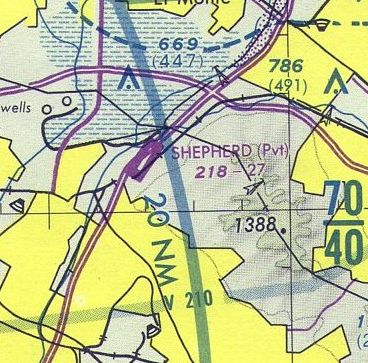
The 1963 LA Sectional Chart (courtesy of Bob Cannon) depicted Shepherd as a private field having a 2,300' unpaved runway.
Lloyd Duke recalled, “In 1963 the 605 Freeway went through the southwest of his property, taking a bit of his runway.
Driving by on the new 605 I was surprised to see the old Twin Bonanza take off from there.
Later he apparently traded the Bonanza for a Beech Barron.”
The Aerodromes table on the 1964 LA Sectional Chart described Shepherd as a private field having a single 2,165' dirt runway.
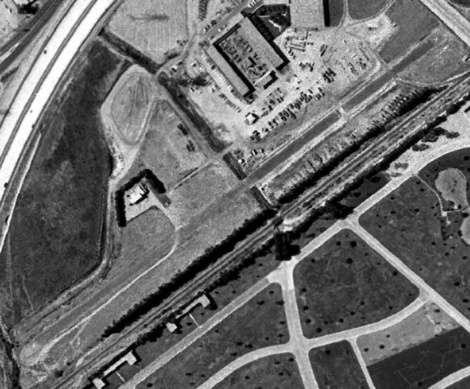
The earliest photo which has been located of Shepherd Field was a 9/1/64 USGS aerial view.
It depicted Shepherd Field as having a single northeast/southwest runway, with a single hangar midway along the northwest side of the runway.
The 1965 LA Local Aeronautical Chart depicted Shepherd Field as having a 2,100' unpaved runway.
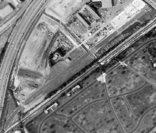
A 1972 aerial view depicted Shepherd Field as having a single northeast/southwest runway,
with a single hangar midway along the northwest side of the runway.
The July 1980 LA Terminal Chart (courtesy of Jim Hackman) depicted Shepherd Field as having a 2,700' paved runway.
The 1981 USGS topo map depicted Shepherd Field as having a single northeast/southwest runway.
Lloyd Duke recalled, “Upon passing over Shepherds in 1984ish,
I noticed that he had kinked the end of his runway to give him a little more breaking room & rollout.
His runway had a displaced threshold so the power poles at the north end of his runway would be avoided.
For takeoff he would start his roll from Rose Hills Road.”
Jere Vandewalle recalled, "In the mid 1980s I saw a twin fly low over the 605 freeway & land just beyond at the foot of Rose Hills east of Los Angeles.
In 1989 when I began flying Shepherd Field was indicated at that location on my LA TCA chart, I believe as a private or perhaps as a closed airfield.
My instructor also pointed it out to me as an emergency alternate while approaching Fullerton from the Northwest.
I remember seeing the white X on the south end of the runway at some point thereafter."
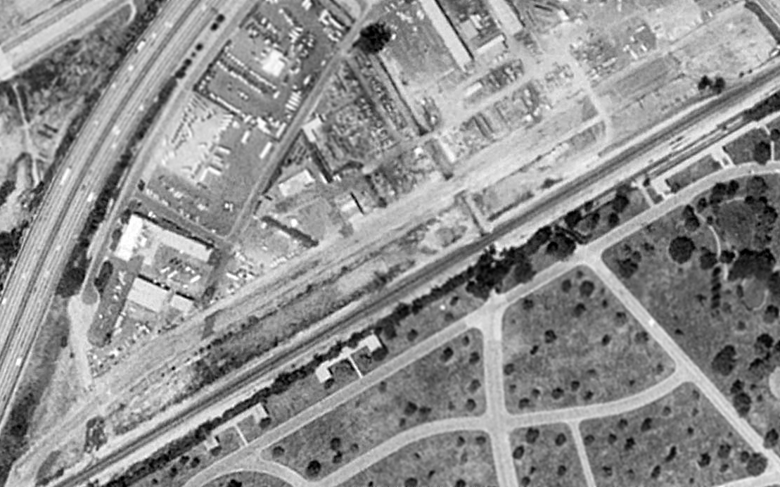
A 1994 USGS aerial photo showed the Shepherd Field runway was still cleared, but appeared to be closed, as at least 3 closed-runway "X" symbols were visible along the runway.
Note that the southwest end of the runway had a slight curve toward the south.
The hangar remained along the north side of the runway. The Rose Hills Memorial Park is visible just to the south of the runway.
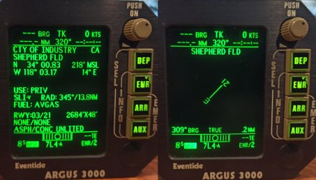
A 2021 photo by Branimir Filovski of the depiction of Shepherd Field on a Eventide Argus 3000 with a 1996 database.
It depicted Shepherd as having a 2,684' asphalt Runway 3/21.
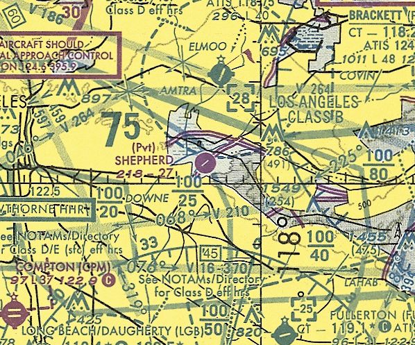
The last aeronautical chart depiction which is available of Shepherd Field was on the January 1998 LA Sectional Chart (courtesy of Ron Plante),
which depicted Shepherd as having a 2,700' paved runway.
Shepherd Field was still depicted as an active private airfield on the July 2000 LA Local Aeronautical Chart (according to Matt Candelaria),
and described as having a 2,700' paved runway.
Shepherd Field's hangar was still standing in a 2003 aerial photo.
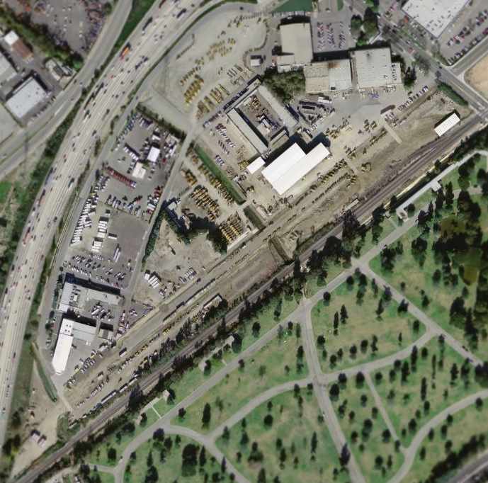
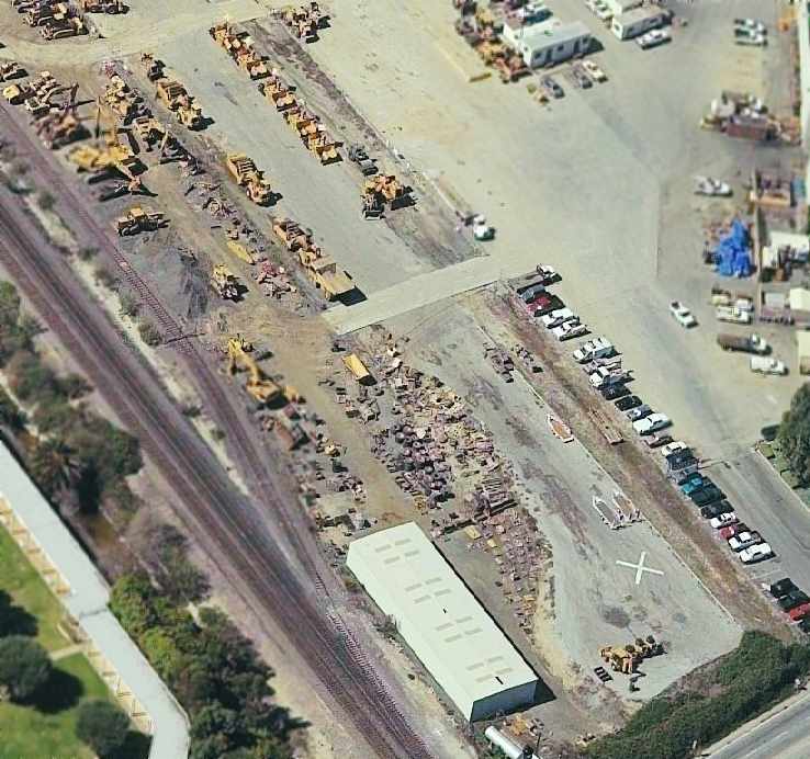
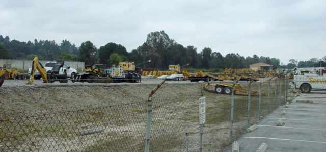
In the March 2004 USGS aerial photo, Shepherd Field's runway was still intact, but was being used to store Caterpillar construction equipment.
The hangar had been removed at some point between 2003-2004.
Earl Shepherd recalled, “Shepherd Field was deactivated in 2004.
My half-brother Bill [Shepherd] III was dealer principal of Shepherd Machinery at that time
and as my father W. W. Shepherd II had just retired from managing the family businesses,
our aircraft had been sold & the field lost its purpose.”
Shepherd Field was no longer listed among active airfields in the October 2004 FAA Airport/Facility Directory data.
Jere Vandewalle reported in 2004, "That runway is still there today.
It has a bunch of Caterpillar equipment parked on it. Quinn Shepherd Caterpillar is still located there."
A circa 2005 aerial photo looking west at the eastern end of Shepherd's former runway
shows the characteristic turn-around pad of a runway at the bottom, as well as a closed-runway "X" symbol which still remained visible.
A 2005 photo by Keith Wood of the northern end of Shepherd Field's runway.
Keith observed, “Note that the northern end - several hundred feet or so - of the runway is raised on a grade,
no doubt to assist in stopping before running off into Rose Hills Road.”
A 2005 photo by Keith Wood of the northern end of Shepherd Field's runway.
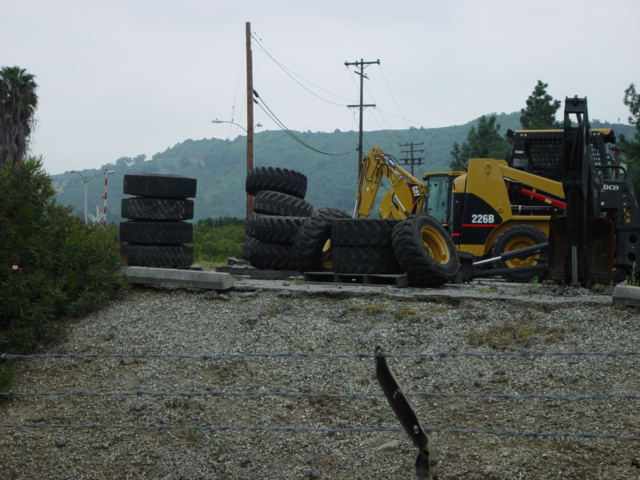
Keith observed, “Those tires are stacked along the edge of the drop-off,
no doubt to keep people from running off the end with equipment.”
Earl Shepherd reported in 2006, “Now that Bill [Shepherd] III sold the dealership to Quinn, the runway is toast.”
A 2011 aerial view showed the northeast half of the runway had been removed.
A 2013 aerial view showed that the remainder of the Shepherd Field runway had been erased.
A 2018 aerial view showed no trace remaining of Shepherd Field.
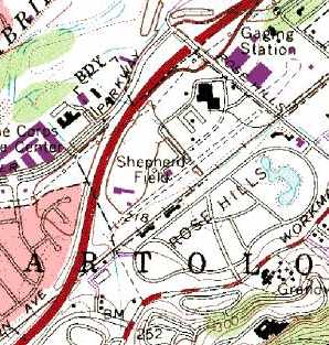
The site of Shepherd Field is located south of the intersection of the 605 Freeway & Rose Hills Road.
Thanks to Jere Vandewalle for pointing out this airfield.
____________________________________________________
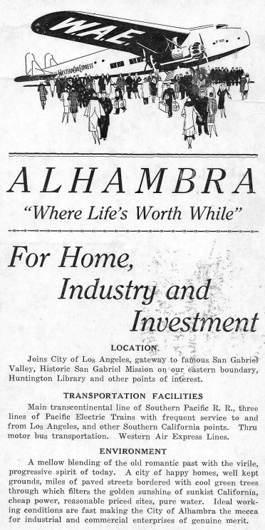
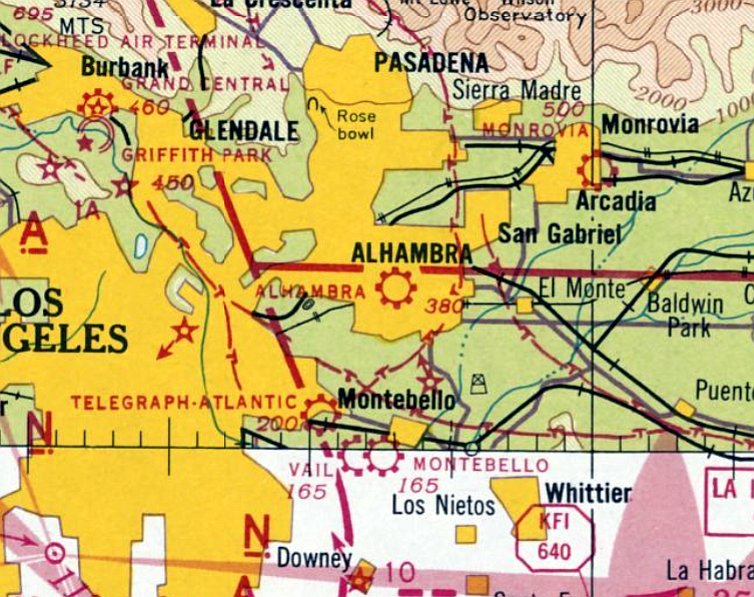
Alhambra Airport / Western Air College Airport, Alhambra, CA
34.078, -118.114 (Northeast of Downtown Los Angeles, CA)
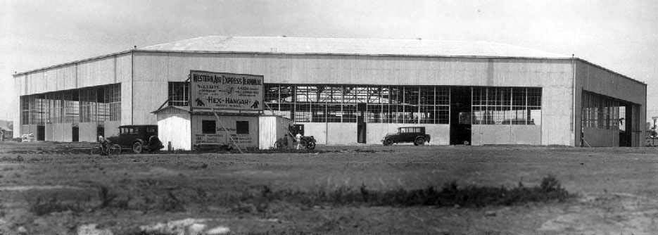
An undated photo of the hexagonal hangar at Alhambra while under construction (photo by Jim Muche, courtesy of Dan MacPherson).
The date of construction of Alhambra Airport has not been determined.
The earliest reference to the field which has been located
was the Standard Oil Company's 1929 "Airplane Landing Fields of the Pacific West" (courtesy of Chris Kennedy).
It described Alhambra Airport as being operated by Western Air Express.
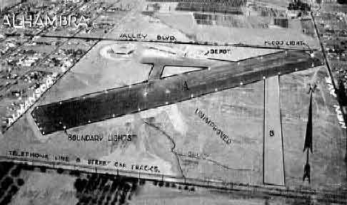
The airfield configuration was said to be a 2,700' oiled northeast/southwest runway, with 2 hangars in the northeast corner.
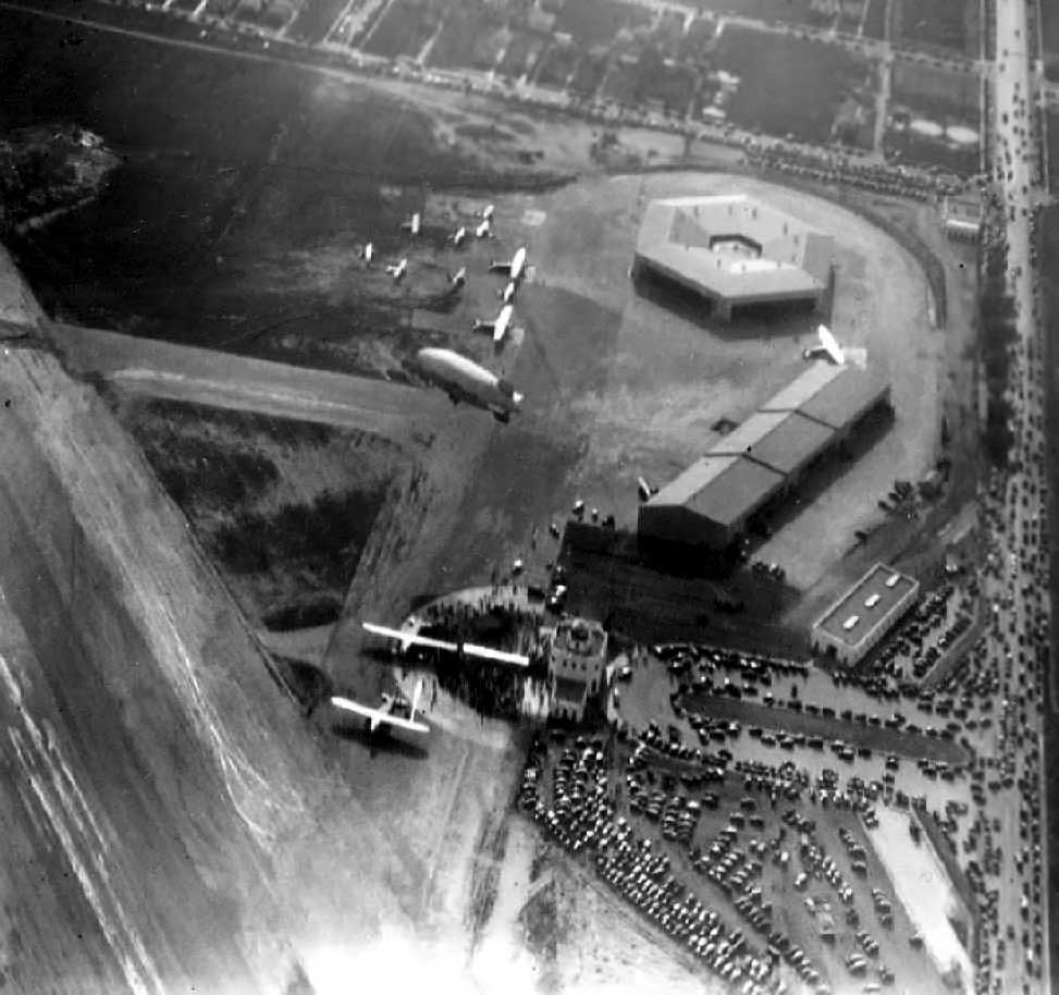
A remarkable aerial view looking west at Alhambra Airport (courtesy of Dennis Parks, Curator Emeritus of The Museum of Flight),
with a blimp visible overflying the field at a lower altitude.
The photo is undated, but may have been taken at an airport dedication ceremony.
A 1929 aerial photo of the hexagonal hangar at Alhambra (courtesy of Bob Cannon).
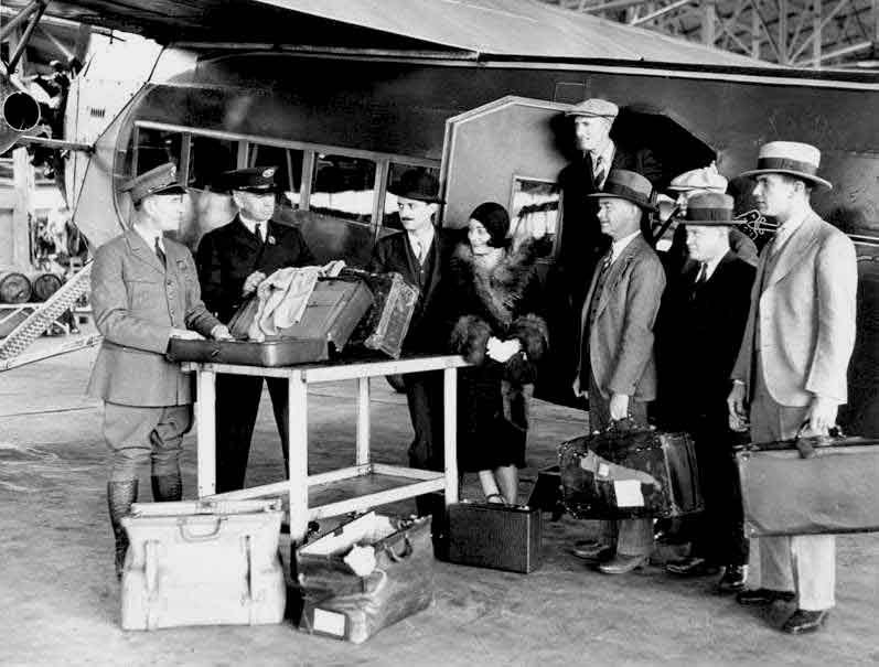
A 1929 photo from the FAA historical files of passengers are checking in with customs before a flight at Alhambra Airport,
in front on an unidentified aircraft (courtesy of Hank Verbais).
The 1930 "Southern California At A Glance" (courtesy of Kevin Walsh) depicted Alhambra Airport as a rectangular property outline.
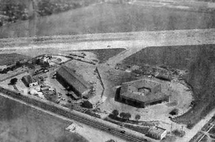
An undated aerial view looking north at Alhambra Airport from the 1930 Richfield Directory (courtesy of Jonathan Westerling)
depicted the field as having 2 runways, with the hexagonal hangar on the northwest side.
A 1930 photo of 4 Tri-Motors outside & inside Alhambra's hexagonal hangar (courtesy of Mark Hess).

A March 1930 photo of a Western Air Express Fokker F-32 at Alhambra Airport.
Western Air Express (the forerunner of Western Airlines) relocated from Vail Field to Alhambra Airport.
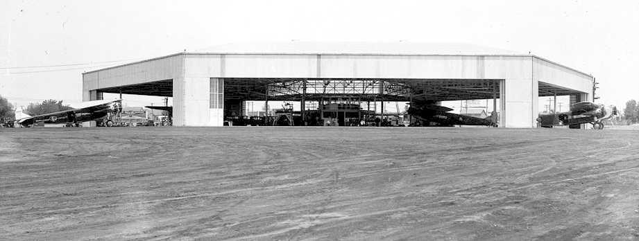
Western built the passenger terminal & what was at the time the largest airplane hangar in the world.
Western operated a fleet of six 12-passenger Fokker transports.
Their large maintenance hangar was shaped like a hexagon,
and had doors on each face so that all 6 aircraft could be worked on simultaneously, a unique feature.
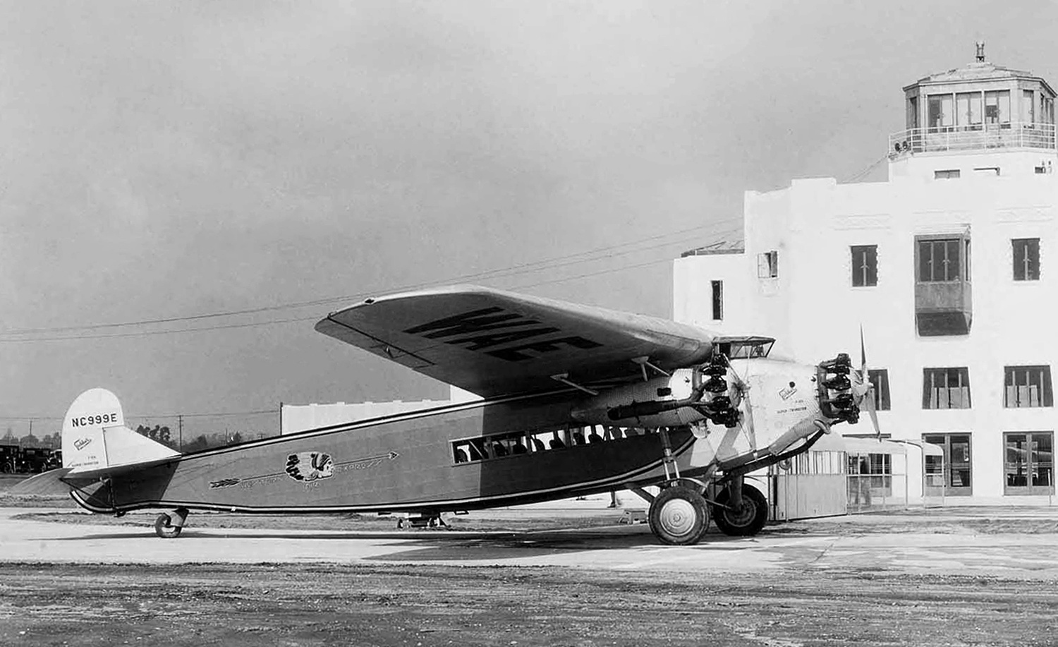
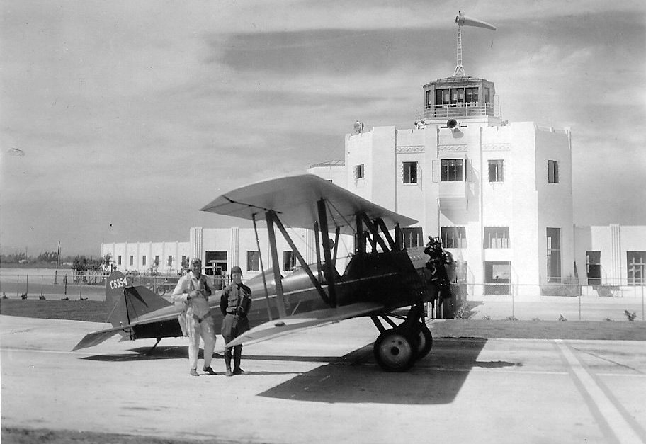
A 3/6/30 photo by Haven Bishop of a Western Air Express Fokker F.10a NC999E C/n 1063 in front of the Alhambra Airport tower.
A postcard commemorating the 4/17/30 dedication of Alhambra Airport (courtesy of Dan DeNicola).
A 9/3/30 photo of a Western Air Express biplane (model undetermined) at Alhambra Airport (courtesy of Gordon Rowley, via Michael Guerin).
Michael Guerin reported, “Shown in the photo are pilot B. Smith & US Forest Service Ranger V. P. Vetter.
The plane was on contract to USFS for prevention & observation work.”
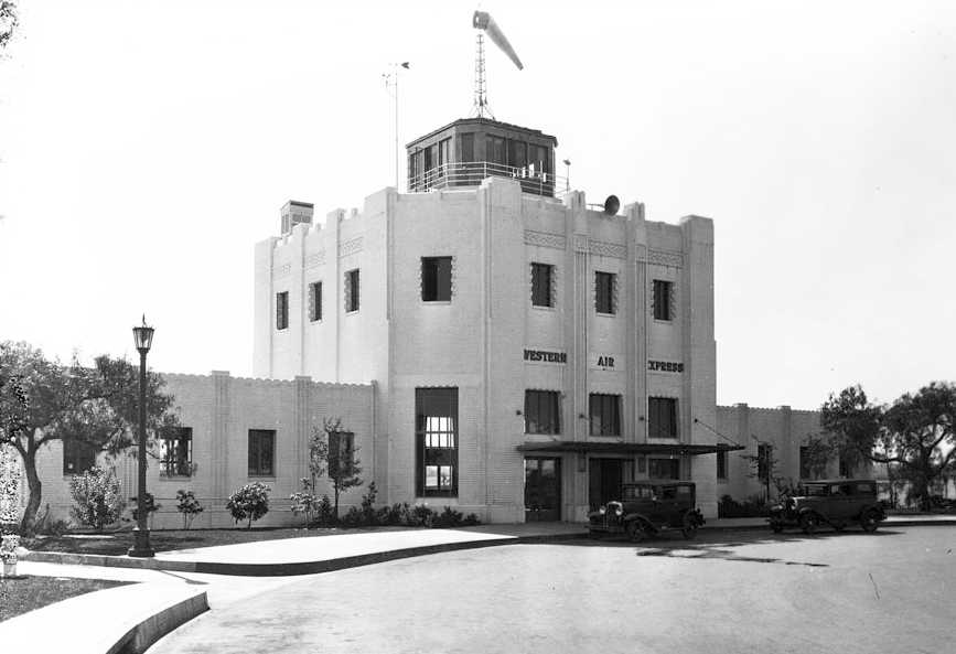
A 1931 photo of Alhambra's Western Air Express terminal (courtesy of Mark Hess).
A 3/19/31 article in The Milwaukee Journal (courtesy of Jonathan Westerling)
reported that “The $2,000,000 Western Air Express airport at Alhambra will be left deserted by the airlines April 15.”
It reported that both Transcontinental & Western Air & Western Air Express were relocating airline operations from Alhambra.
After the major airlines relocated to airfields in Burbank & Glendale,
Alhambra Airport was left to the private & small commercial operations, including the Western Air College flight school.
The earliest aeronautical chart depiction which has been located of Alhambra Airport was on the June 1932 LA Sectional Chart.
It depicted “Pasadena Alhambra” as a commercial/municipal airport.
A 1936 aerial view by Bob McCorkle looking northeast at the hexagonal hangar & terminal building at Alhambra Airport (courtesy of Ed Maloney, via Dan MacPherson).
The houses at the lower-left, along Almansor Avenue, are mostly all still there.
A 1936 photo of a Stearman piloted by Paul Mantz which groundlooped at Alhambra Airport.
According to Dan MacPherson, as of 2003 the rudder of this plane is still owned by John Underwood..
Photo is courtesy of Ed Maloney, via Dan MacPherson.
An undated photo of a Fokker F-10A Tri-Motor inside the hexagonal hangar at Alhambra.
Photo is courtesy of Jim Muche, via Dan MacPherson.
Due to the field's proximity to Hollywood, a large number of movies were shot on location at Alhambra Airport,
including "Thirteen Hours by Air" (1936) & "Danger Flight" (1939).
The Airport Directory Company's 1937 Airports Directory (courtesy of Bob Rambo) described Alhambra Airport as having 2 runways,
with the longest being a 2,870' "surfaced" northeast/southwest runway.
Vic Matloff recalled, “I think it was 1937 or 1938... my dad & I would drive over to the Alhambra Airport to watch the planes take off & land.
I guess Bob McCorkle thought I was a cute kid, maybe because of my Malamute that was as large as I,
because he came over to the fence & asked me if I wanted to go for a ride.
At first I was unsure, but I asked him if i could take my dog with me. My dad said it was OK with him so off we went.”
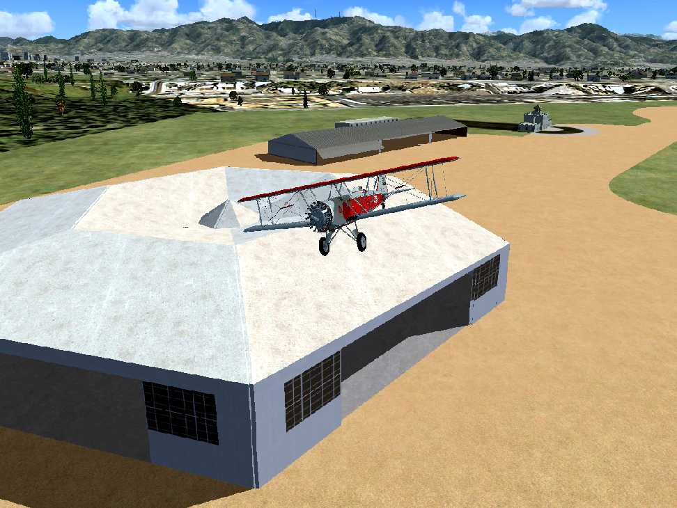
A flight simulation scenery re-creation of a Boeing 40 biplane overflying the Alhambra hangar.
An undated aerial view looking north at Alhambra Airport from The Airport Directory Company's 1938 Airports Directory (courtesy of Jonathan Westerling).
The directory described Alhambra Airport as a square field having 2 runways,
with the longest being a 2,870' "surfaced" northeast/southwest runway.
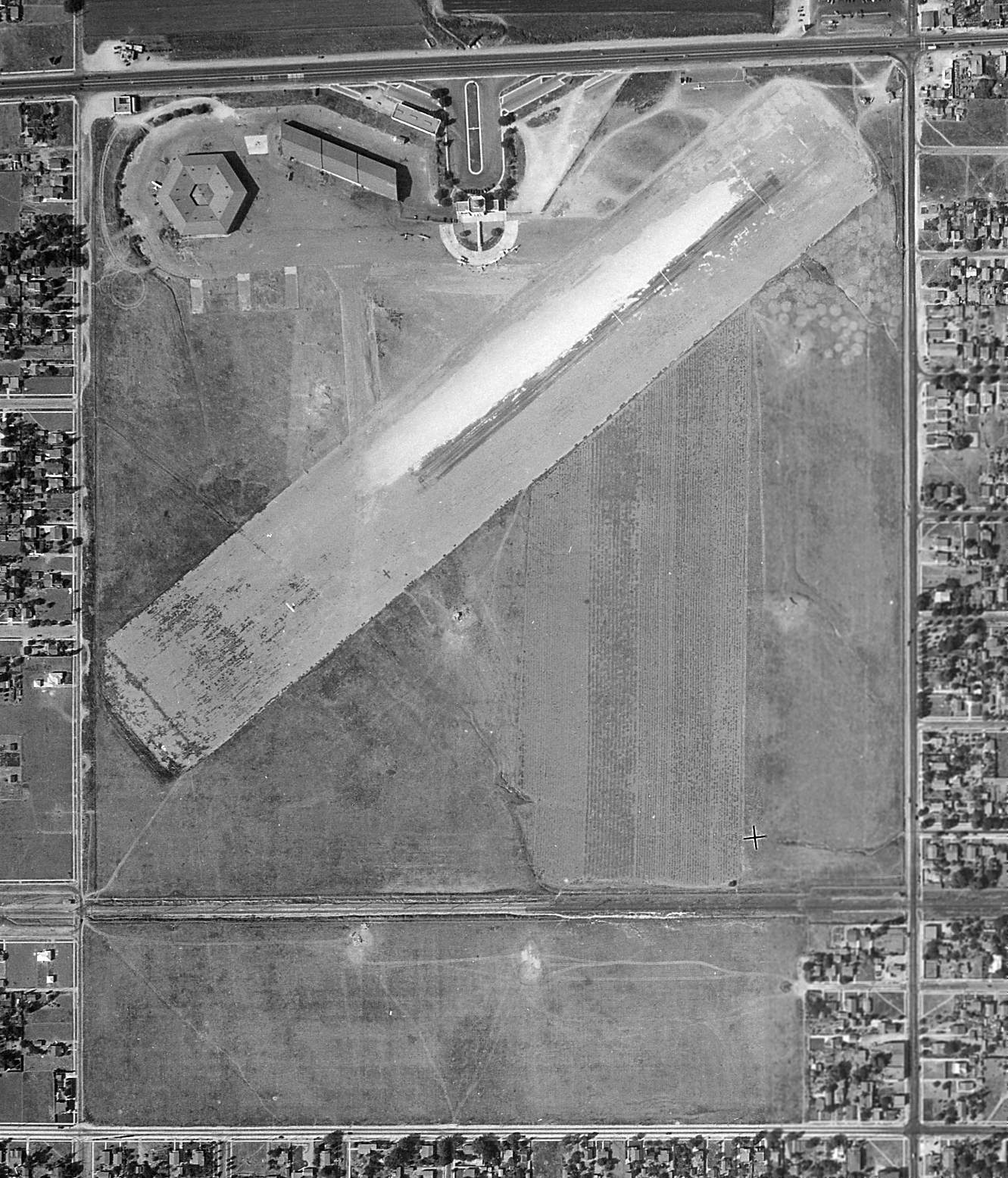
A 9/12/38 aerial view (from the UCSB Library) showing the hexagonal hangar & terminal building at Alhambra Airport, and its northeast/southwest runway.
There were numerous aircraft visible on the field, including one taking off toward the southwest.
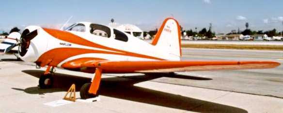
A Harlow PJC-2, manufactured in 1938 at the Alhambra Airport.
Max Harlow was an instructor at the Pasadena Junior College,
and the students of the Aero-Tech program constructed the Harlow PJC-1 through PJC-4 aircraft.
In 1938, with war looming, Alhambra Airport became an official shipping point for Lockheed's military airplanes,
including large numbers of P-38 Lightning fighters.
The last photo which has been located showing Alhambra Airport in use was a 1939 photo of Bob McCorkle's Stinson at the field.
In the right background, over the tail of 385 Echo is "Crawfords Corner", a fixture in Alhambra for many years (at Valley Blvd & New Ave).
Photo is courtesy of Ed Maloney, via Dan MacPherson.
Alhambra Airport, as depicted on the October 1941 LA Sectional Chart (courtesy of Chris Kennedy).
A 1942 street map (courtesy of Gary Alexander) depicted the Alhambra Airport.
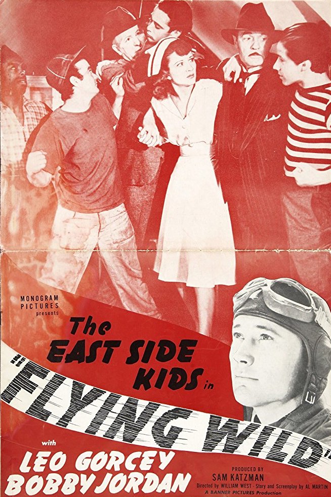
The 1941 movie “Flying Wild” was filmed at Alhambra Airport.
Its plot: “A group of young men who work at an aviation factory begin to suspect that a doctor who runs an air ambulance service
is secretly a spy transporting secret information from the plant to enemy agents.”
Other movies shot on location at Alhambra Airport included “They Met in Bombay" (1941) & "Flight Lieutenant" (1942).
Alhambra Airport continued in operation by its private owners until 1943, when the 157 acre property was put up for sale.
The city of Alhambra took over the property the following year.
The last photo which has been located showing Alhambra Airport still open was a 7/28/43 aerial view looking east
from the 1945 AAF Airfield Directory (courtesy of Scott Murdock).
The 1945 AAF Airfield Directory (courtesy of Scott Murdock) described Alhambra Airport
as a 150 acre rectangular field within which was a single 2,830' bituminous northeast/southwest runway.
The field was said to have 2 steel hangars, with the largest being its signature 144' hexagonal structure.
Alhambra Airport was described as being owned & operated by private interests.
Alhambra was depicted as a civil airfield on the 1945 San Diego Sectional Aeronautical Chart (courtesy of John Voss).
In 1945, Harlow Aircraft Company purchased the airport & used it to manufacture small aircraft.
Max Harlow was an instructor at the Pasadena Junior College,
and the students of the Aero-Tech program constructed the Harlow PJC-1 through PJC-4 aircraft.
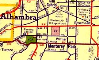
On a 1946 LA street map (courtesy of Dan MacPherson) the airport was depicted as "Western Air College Airport".
Note that the Western Air College had operated only 4 years before at another airport very close to the east, in Rosemead.
The last aeronautical chart depiction which has been located of Alhambra Airport was on the August 1946 LA Sectional Chart.
In 1946, Harlow sold off to real estate developers who subdivided the property, bringing an end to the airport.
Alhambra
Airport was no longer depicted on the February 1947 San Diego
Sectional Aeronautical Chart (courtesy
of Chris Kennedy).
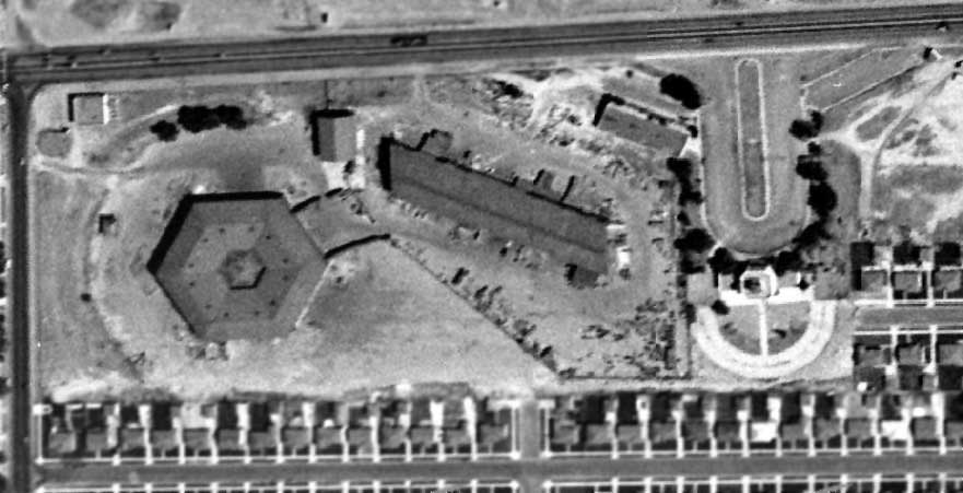
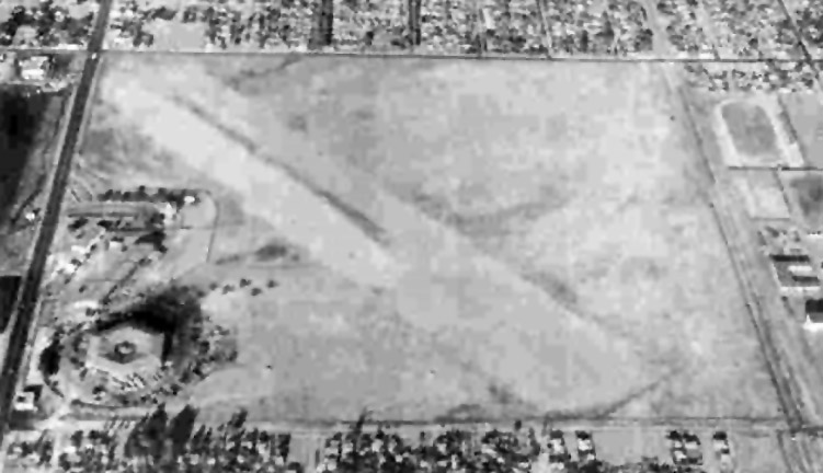
A 1948 aerial view shows Alhambra's distinctive hexagonal hangar, long rectangular hangar, and control tower building were still standing,
although housing had been built over the site of the runways.
A 1953 aerial view showed that the distinctive hexagonal hangar still remained standing.
Bob Holderness recalled of Alhambra Airport, “In 1954 we moved into a house on Camelia Drive
which ran from a dead end at the truncated main runway down to New Avenue. I was 10 years old.
At that time the tower & the hangars were still there,
and the hexagonal hangar was used for the construction & decoration of the Rose Parade floats.
We played serious sand lot (even coed) baseball on the main runway.
The tower was occupied by a skeleton office crew of some sort until about December, 1956 or so;
that’s when we found it vacant, broke in & played tag inside the tower
(it had a neat metal staircase up to the top of the tower).
The cops were always coming out on burglary calls, but 10 year old boys were hard to catch.
There were great echoes inside that empty building from the top of the tower.
A demolition operator named Al Walker knocked down the tower in about 1957.
After he knocked down the tower, we played in the ruins as long as we could
and then we salvaged the used red brick & sold it to the neighbors (including my Dad).
I think we got 6 cents per brick.”
A 1972 aerial view showed that a shopping center had covered the site of the hangars,
erasing any trace of Alhambra Airport.
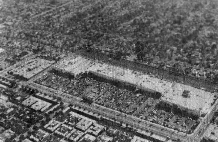
A post-WW2 aerial view looking southeast at what had become of the site of Alhambra Airport - a shopping plaza (photo courtesy of Bob Cannon).
Portions of the airport land were redeveloped as the Alhambra Valley Shopping Center & Mark Keppel High School,
and the former airport property has also been bisected by the 10 Freeway.
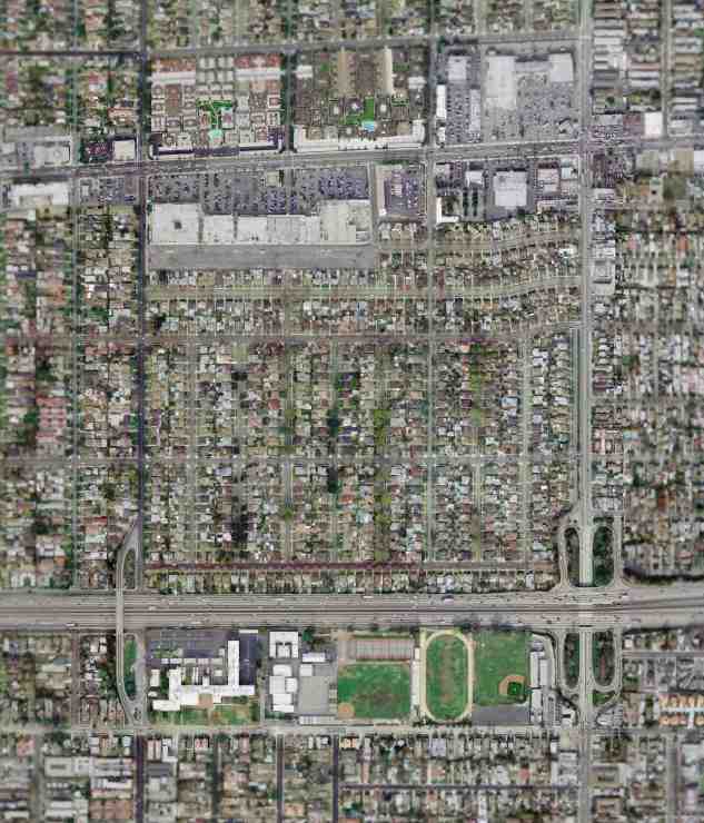
The March 2004 USGS aerial photo shows that no trace of Alhambra Airport remains visible.
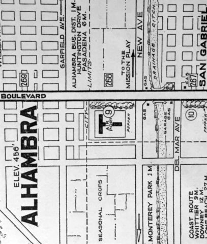
The Alhambra Airport property was bounded by Valley Boulevard on the north, Hellman Avenue to the south,
Del Mar Avenue on the east, and of Garfield Avenue on the west.
Thanks to Jerry Mullady for pointing out this airfield, and to Dan MacPherson for additional background.
See also:
http://www.spiritone.com/~bannrbob/photos.htm
http://employees.oxy.edu/jerry/alhambra.htm
____________________________________________________
Ross Field / Arcadia Intermediate Landing Field / Mission Field, Arcadia, CA
34.134, -118.036 (Northeast of Downtown Los Angeles, CA)
Undated photo of B.F. Goodrich balloons (nicknamed "Elephants") at Ross Field.
The B.F. Goodrich balloons used at Ross Field were 95' long,
and filled with 37,000 cubic ft of hydrogen, which was provided by a hydrogen plant at Ross Field.
A total of 184 acres of land were donated by Anita Baldwin to the government in 1918
to construct the Army's Ross Field Balloon School.
It became America's premiere training ground for the Balloon Signal Corps
when another school at Fort Omaha NE proved unsuitable.
Buildings that once housed Lucky Baldwin's racehorses were converted into barracks,
and a bachelor officer's quarters building was built.
Deflated balloons were stored at first under the grandstands of Baldwin's racetrack.
The school provided instruction both for the balloon's ground crews & their 2-man observation crew.
They were trained to observe ground fire, and keep an eye out for fighter aircraft.
A collage of undated postcards of Ross Field from the Jack McCaskill collection (courtesy of Dan MacPherson).
The center picture shows Ross Field's BOC building (which still stands as of 2005).
The Ross Field Balloon School closed after WW1.
Ross Field saw some post-WW1 reuse as a civil aircraft airfield,
but this was limited to the small size of the airfield, due to its original purpose as a balloon field.
A circa 1920 photo of 3 balloons landing or ready to take-off at Arcadia Balloon School (courtesy of the UCLA Library Special Collections, via Kevin Walsh).
A circa 1920 photo of a Merrill glider in flight in front of the Ross Field hangars (courtesy of Ken Morrison).
Professor Merrill used Ross Field for glider experiments after WW1.
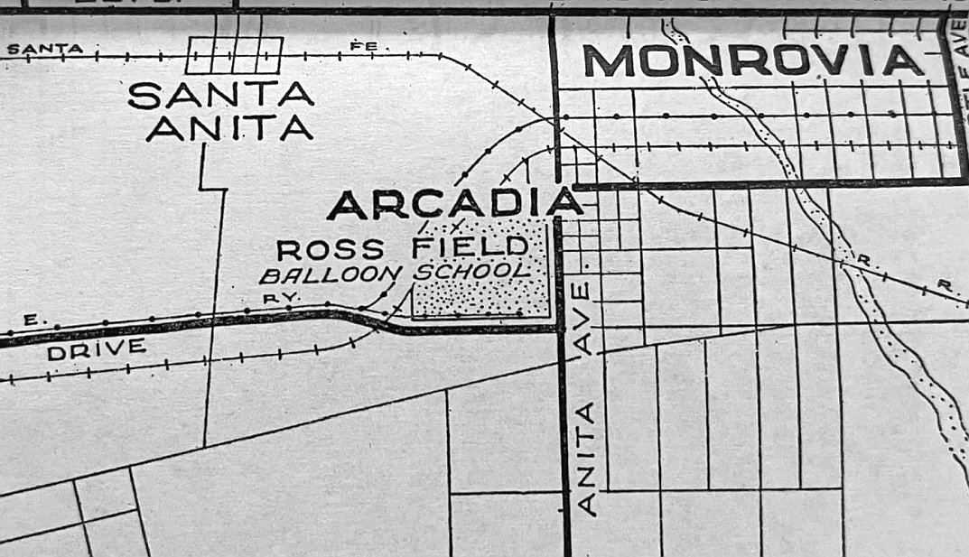
A circa 1920 street map (courtesy of Kevin Walsh) depicted the “Ross Field Balloon School” as a rectangular property outline.
According to the book “Monrovia Airport Alias Foothill Flying Field” by John Irwin, Ross Field was used as a private field starting in 1922.
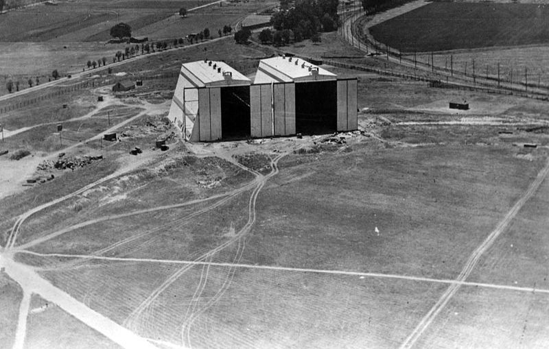
A 1922 aerial view looking southwest at the massive Ross Field balloon hangars.

An undated aerial view looking northeast at Ross Field from a 1922 airfield directory.
It depicted the airfield within the oval track, but the dirigible hangar on the southwest side was either under construction or being removed.

A 5/18/22 airfield directory depicted Ross Field as having a landing field within an oval track & a dirigible hangar on the southwest side.
Ross Field was where aviation legend Pancho Barnes (see Barnes Airfield) learned to fly.
The book "The Lady who tamed Pegasus" by Grover Ted Tate (courtesy of Dan MacPherson)
contains Barnes account of her very first airplane flight:
"A main named Ben Catlin had 2 airplanes on the field.
Fairchild Aerial Mapping Concern ad a couple of old DH-4s.
Western Air Express came in from time to time, and several other pilots kept their planes on the field.
My cousin, Dean Banks, introduced me to Mr. Catlin & told him that I would like to learn to fly.
After I told him that I wanted to start right away, he stuck a helmet & goggles on me,
Strapped me in the back seat of an old airplane, and we took off.
We flew around for a while, did a few mild maneuvers, and landed.
We agreed on another flight the following day & what a flight that was!
He did everything that could be done with an airplane: stalls, loops, spins, rolls - the works."
According to the book “Monrovia Airport Alias Foothill Flying Field” by John Irwin, the Army divested itself of Ross Field on 3/1/26.
The Standard Oil Company of California's 1927 "Airplane Landing Fields of the Pacific Coast" (courtesy of Chris Kennedy)
described Ross Field as a "Permanent" airfield, with an northeast/southwest runway measuring 2,300' x 1,000'.
The field was said to have "two large, white hangars".
The field was said to be "owned by the U.S. Government, for the use of Government airplanes & is not open to all pilots.
Only to be used for emergency landings."
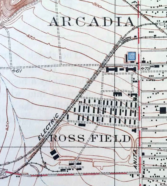
Ross Field, as depicted on the 1928 USGS topo map (courtesy of Kevin Walsh).
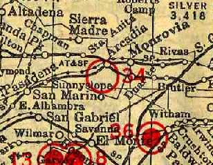
The 1929 "Rand McNally Standard Map of CA With Air Trails" (courtesy of Chris Kennedy)
described Ross Field as an auxiliary airfield operated by the Air Corps.
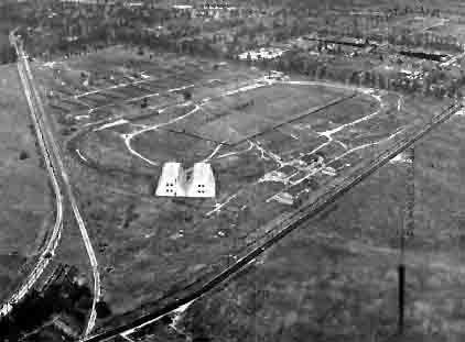
An undated aerial looking northeast at “Arcadia Intermediate Landing Field” from the 1930 Richfield Airport Directory (courtesy of Jonathan Westerling)
depicted the 2 balloon hangars of the Ross Field Balloon School on the southwest side of a grass landing area.
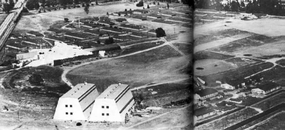
A circa 1930s aerial view of Ross Field looking northeast.
The 2 balloon hangars of the Ross Field Balloon School are in the lower left.
One of the hangars was used in 1930 for filming of the Zeppelin sequence for the movie "Hells Angels" (which was directed by Howard Hughes).
The arctic set used in 1931 for the movie "Dirigible" is the white area just above & to the left of the hangars.
Photo is from "The Motion Picture Stunt Pilots" by Hugh Wynne (courtesy of Dan MacPherson).
"Ross Field, U.S. Army" was described in a 1932 LA Chamber of Commerce table of LA-area airfields (courtesy of K.O. Eckland)
as having 2 runways: a 2,500' east/west strip & an 1,100' north/south strip.
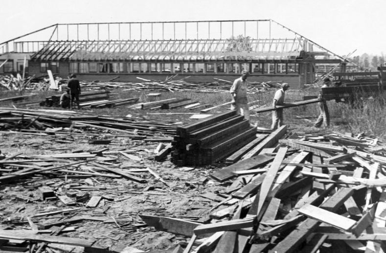
A 1932 photo of salvaging the lumber from the balloon school demolition on Ross Field.
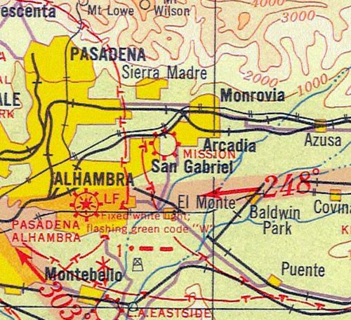
Ross Field may have been briefly operated under the name of “Mission” Field, as that is how it was labeled on the 1932 LA Sectional Chart (courtesy of Roger Connor).
Ross Field / Mission Field was evidently closed at some point between 1932-34,
as it was no longer depicted on the July 1934 LA Sectional Chart.
The Ross Field property largely sat idle until 1935, when it was transferred to the city of Arcadia.
Ross Field was no longer depicted on a 1940 LA street map (courtesy of Dan MacPherson).
However, Keith Wood reported, “I ran across a military intelligence record from the WWII era
which lists 'Arcadia Balloon Field' as requiring security upgrade review.
The site location is the same as Ross Field, which [was] not on the street map in 1940.
Put the 2 together & you get a field which was still open but probably not on the map for security reasons.
The 'elephants' were barrage balloons, originally sold to the Brits but then adopted by the War Department here.
Thin steel cables were dangled from the balloons -
these would waft in the breeze & create a hazard for low-flying aircraft for hundreds of feet around & below the balloons.
Several of these got loose during the early days of the war over LA.
One landed in the yard of the elementary school then attended by my mom.
It was sufficiently damaged that the recovery crew chopped up the bag & gave pieces to the students.”
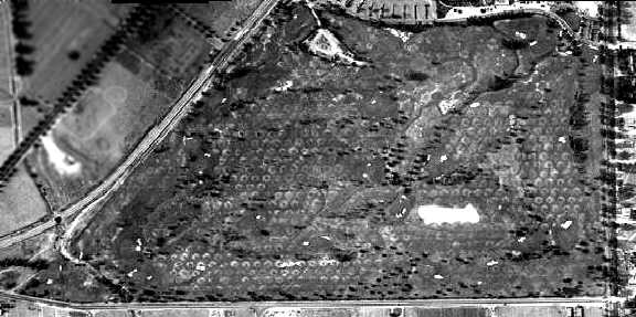
A 1948 aerial view of the site of Ross Field shows the property to be covered with hundreds of unidentified circular features.
Where these related to the use of property for barrage balloons during WW2?
The city later sold the Ross Field property to the county, to be redeveloped as the current Santa Anita Golf Course.
A small historical plaque at the site commemorates its prior role.
A 1972 aerial view showed that the Ross Field site had been covered with the golf course,
but the pattern of circular markings over the site was still plainly evident.
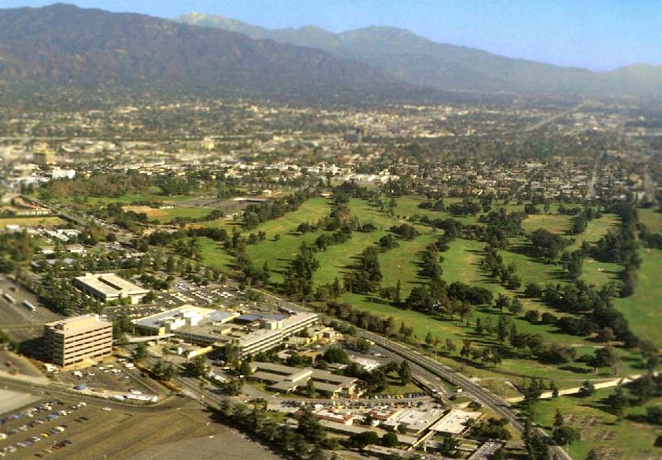
A 1995 aerial view of the site of Ross Field by Jack Rankin (courtesy of Dan MacPherson).
Two 1990s photos by Dan MacPherson of the former BOC at Ross Field, reused as the Elks Lodge at 27 Huntington Drive.
The wall is a remnant of a free-standing swimming pool - note the diving board mount next to phone pole.
Dan MacPherson reported in 2005, "The city of Arcadia is trying to have these buildings demolished,
so they can expand a car lot."
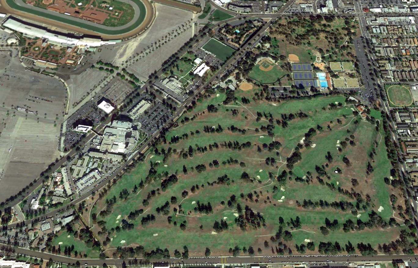
A 2016 aerial view looking north at the site of Ross Field.
The site of Ross Field is located southwest of the intersection of Santa Anita Avenue & Huntington Drive.
See also: San Gabriel Valley Newspapers, 7/22/94.
____________________________________________________
Bellflower Airport, Bellflower, CA
33.892, -118.112 (North of Long Beach, CA)
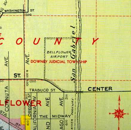
Bellflower Airport, as depicted on a 1946 street map (courtesy of Dan MacPherson).
This short-lived little general aviation airport was evidently established shortly after the end of WW2.
Bellflower Airport was not yet depicted on the August 1946 LA Sectional Chart.
According to Dick Morris, newspaper research indicates “the Bellflower Airport was established in 1946 on about 53 acres by Jay Walker.”
The earliest depiction which has been located of Bellflower Airport
was on a 1946 street map (courtesy of Dan MacPherson).
It depicted Bellflower Airport as occupying a mostly rectangular plot of land on the west bank of the San Gabriel River.
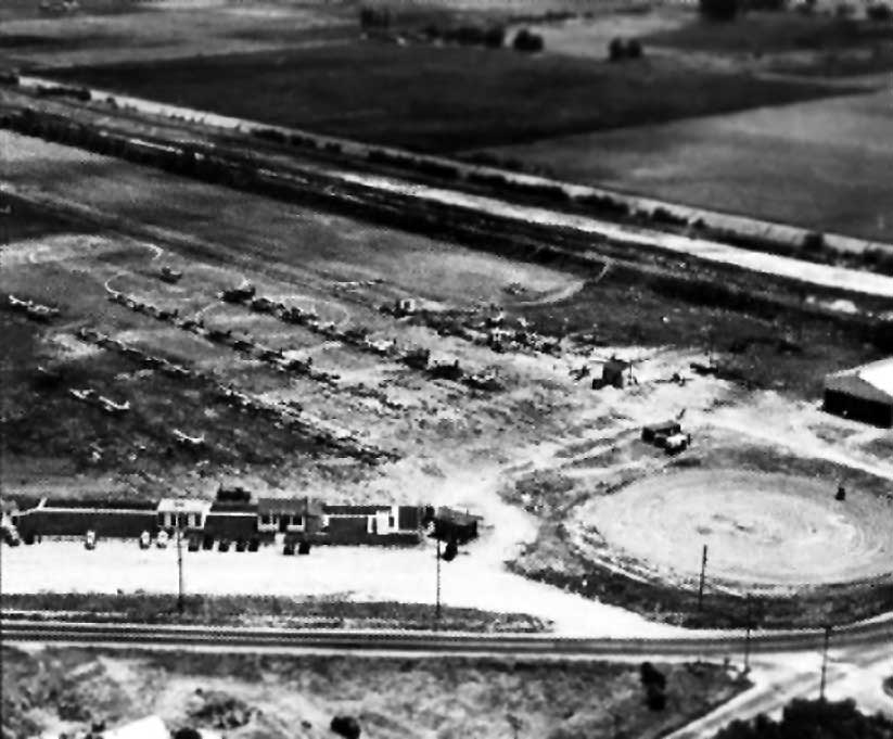
A circa 1946 aerial view looking northeast at “Bellflower's New Airport” (courtesy of Jim Beckham, via Brian Marcroft, via Dan MacPherson).
It depicted the field as having dozens of light planes, as well as as several small buildings & at least one hangar.
Dick Morris reported, “I found an article in the 11/25/46 Northwest Arkansas Times saying a 12-year-old had been checked out on a solo flight by the CAA
after only 7 hours of instruction at the Bellflower, California Airport.
So apparently there was a flight school at Bellflower at that time.”
Nate Calkins reported, “My great-grandfathers friend, Fred Brach was an instructor at Bellflower Airport & during a visit in 1946 offered to take my grandmother Mary Glee Chesneyup for a ride.
She was very enthusiastic about the experience & after several visits over the next few months, Fred pondered the thought of teaching a 12 year old girl to fly.
After 7 hours of instruction she was checked out as a solo pilot by CAA inspector H.G. Denner.
In the 4 years waiting for her license, she became a child celebrity flying in numerous airshows & races, sponsored by Sperry Flour & featured in a few teen magazines of the time.”
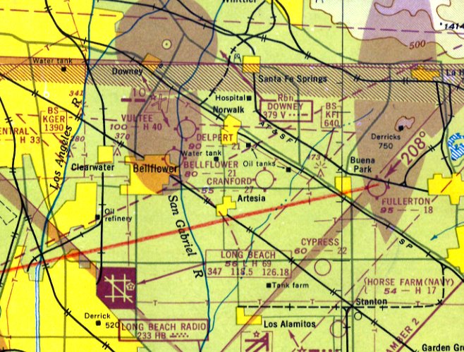
The earliest aeronautical chart depiction which has been located of Bellflower Airport was on the 1947 LA Local Aeronautical Chart (courtesy of Tim Zukas).
It depicted Bellflower as having a 2,100' unpaved runway.
Dick Morris reported, “A 9/22/49 article announced that the Bellflower Civil Air Patrol Squadron was holding an 'Air Circus'.
Planned were exhibits, a parade, and a demonstration of spraying by a crop duster.
Another associated group was the 'Air-O-Crats', a flying club.”
Dick Morris reported from research in several newspapers, “There was apparently a crop dusting business operated from the airport,
but I couldn't tell if [Jay] Walker was an owner.
In an 8/5/50 article there is a photo of him standing next to a crop duster that had been shot at while piloted by Bob Hall.
There was apparently a second plane as Hall was crop dusting when the reporter took the photo at the airport.”
Dick Morris reported, “The sale of the airport was announced in an article dated 9/28/50.
The new owner was James Most of Most Aviation Co., Los Angeles.
Most's interests appeared to include crop dusting & he was also a Cessna dealer.”
Ron Most recalled, “Jimmy Most was my uncle & owned J.L. Most Aviation Company at the Bellflower Airport [in] 1950.”
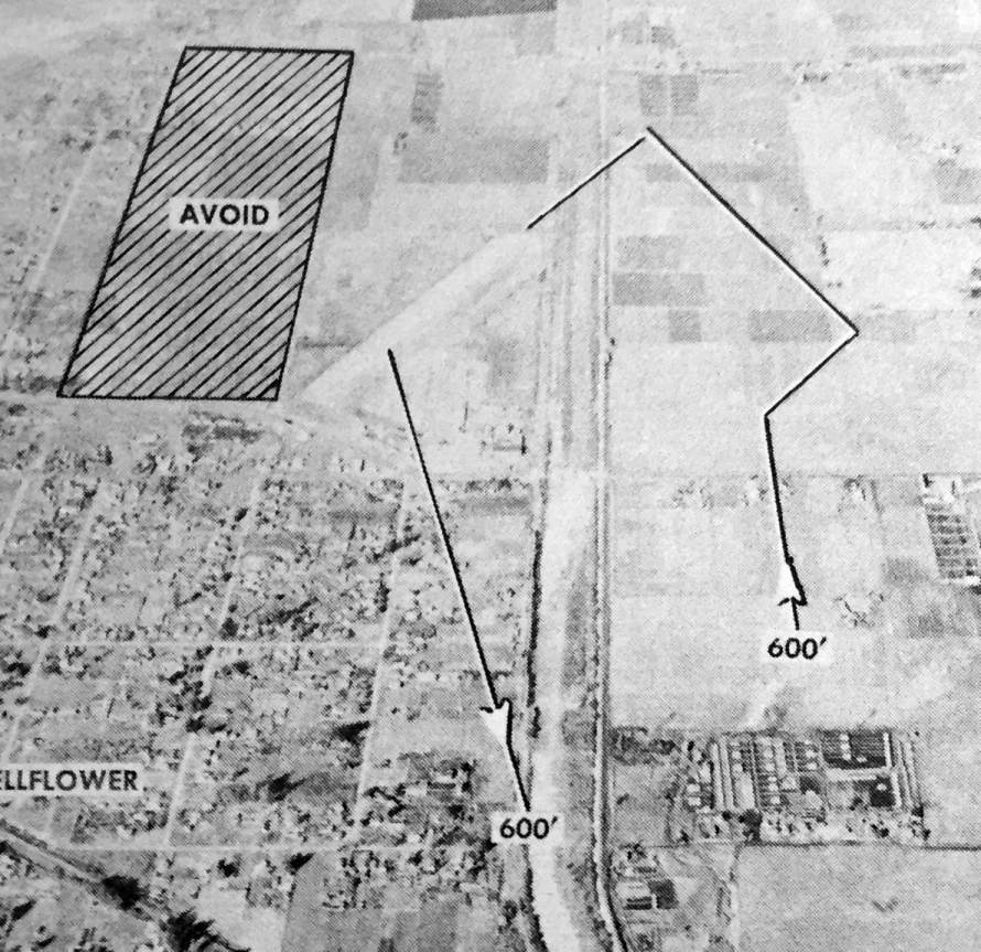
The last photo which is available of Bellflower Airport was an undated aerial view looking north from the 1950 Air Photo Guide (courtesy of Kevin Walsh).
It described Bellflower Airport as having a 2,650' asphalt & dirt Runway 2/20,
and listed the managers as J.F. Walker & Rolland Ward.
The 1951 USGS topo map depicted Bellflower Airport as having a northeast/southwest runway with a parallel taxiway & several small buildings along the south side.
Dick Morris reported, “A 5/6/51 L.A. Times article says the Bellflower Airport
was one of the first to install automatic lighting which could be turned on by the pilot.”
Dick Morris reported, “By 1952, the County Planning Commission & Board of Supervisors were working to close the airport
due to complaints from nearby residents about noise & safety concerns.
James Most took to the courts. A 7/20/52 article cited Most's claims that the 2,200' runway was one of the busiest in the country.
More than 100 airplanes, most of them owned by individuals were based there.
Seventy-five students attend a GI flying school & 100 members of the Civil Air Patrol used the field.
The county board of supervisors revoked the permit in October, 1952.”
Dick Morris reported, “A November 1952 ad for J.L. Most Aviation, Bellflower Airport, 10451 E. Center
offered a C.A.A. approved school, charter service, aircraft rentals, aircraft for training, and complete aircraft maintenance.”
Dick Morris reported, “A 1/13/53 article said that 'the crop dusting school is again under way'.
This article also said he was due back from the Cessna plant & was ferrying a new Model 170.
A 1/23/53 article said that after considerable practice runs in a Piper Cub,
with Ted Mattox at the controls & Shirley Blocki operating the camera,
Most Aviation Company was going to offer aerial photo services. His 2/1/53 ad targeted veterans for flight training.”
A 1953 aerial view showed Bellflower Airport as having a single unpaved north/south runway,
with a few small hangars & a dozen light aircraft on the south side of the property.
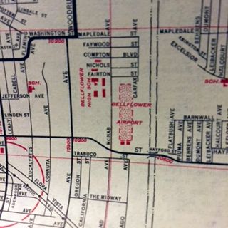
A 1953 street map (courtesy of Kevin Walsh) depicted Bellflower Airport as a north/south rectangular property outline.
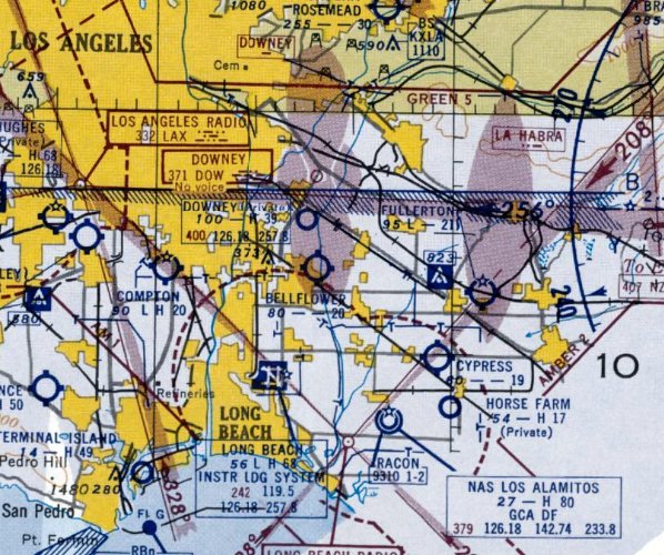
The last depiction which has been located of Bellflower Airport was on the September 1953 LA Sectional Chart.
It depicted Bellflower as having a 2,000' unpaved runway.
Dick Morris reported, “A 9/6/53 article said that planes were still operating.
The county board of supervisors ordered it closed by 4/21/53.
Most requested an injunction which was being heard in Compton Superior Court.”
Bellflower Airport was no longer depicted on the March 1954 LA Sectional Chart.
According to Dick Morris, “An ad in November, 1954, touted Bellflower Airport Gardens, 2-bedroom houses with colored fixtures,
'Built on the site of the discontinued Bellflower Airport'.”
A 1956 aerial photo showed the majority of the Bellflower Airport site was covered by houses, but several hangars remained on the southern side.
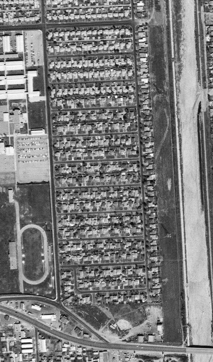
A 2/2/63 USGS aerial photo showed the majority of the Bellflower Airport site was covered by houses, but several hangars remained on the southern side.
According to Dick Morris, “A couple of hangars remained until the mid-1960s.”
Although some sources have indicated that the Bellflower High School Gymnasium was originally a Bellflower Airport hangar, relocated from across the street,
this appears to be contradicted by the 1953 aerial photo, which shows the high school gymnasium already extant
even though the airport (& its hangars) were still intact on the opposite side of the street.
Dick Morris observed, a 1972 aerial photo showed “the area closest to the road was covered by houses
and all remaining buildings & been removed & the ground graded.”
A 1974 aerial view showed that the site of Bellflower Airport had been covered with housing.
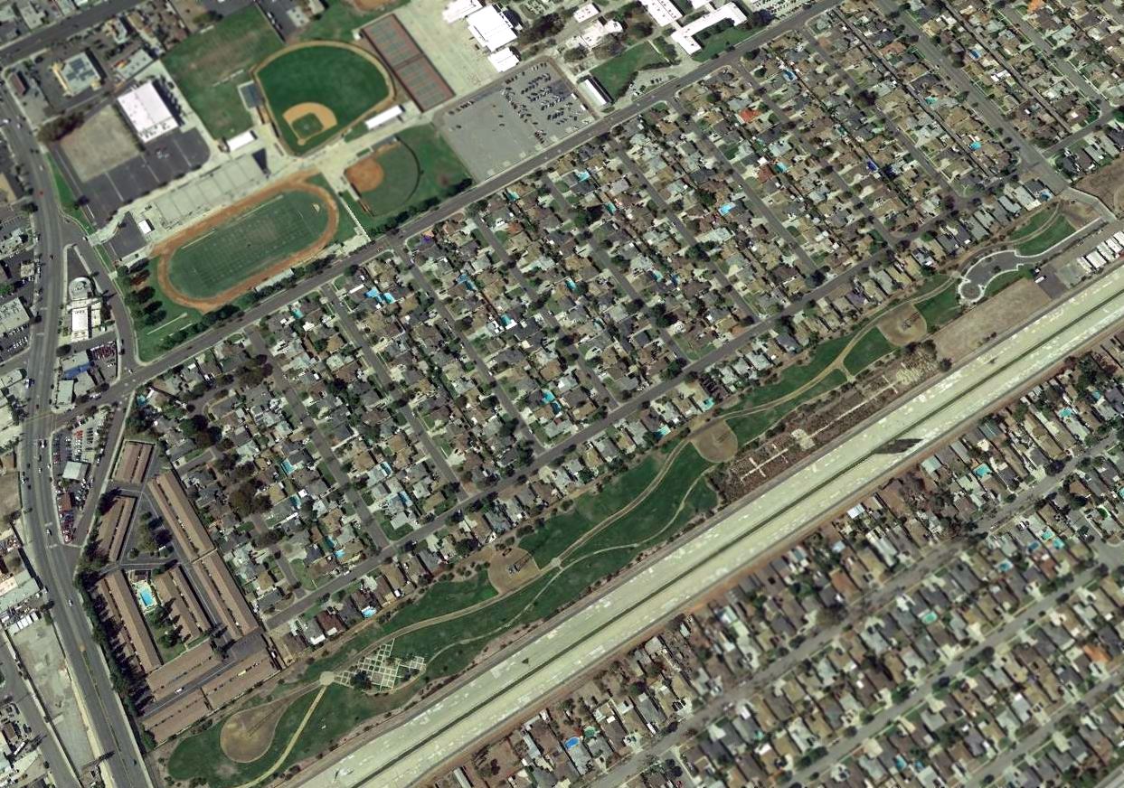
A 2016 aerial view looking northwest shows the site of Bellflower Airport filled in with dense housing, and not a trace appeared to remain of the former airport.
The site of Bellflower Airport is located northeast of the intersection of Alondra Boulevard & McNab Avenue.
____________________________________________________
____________________________________________________
This site covers airfields in all 50 states.