
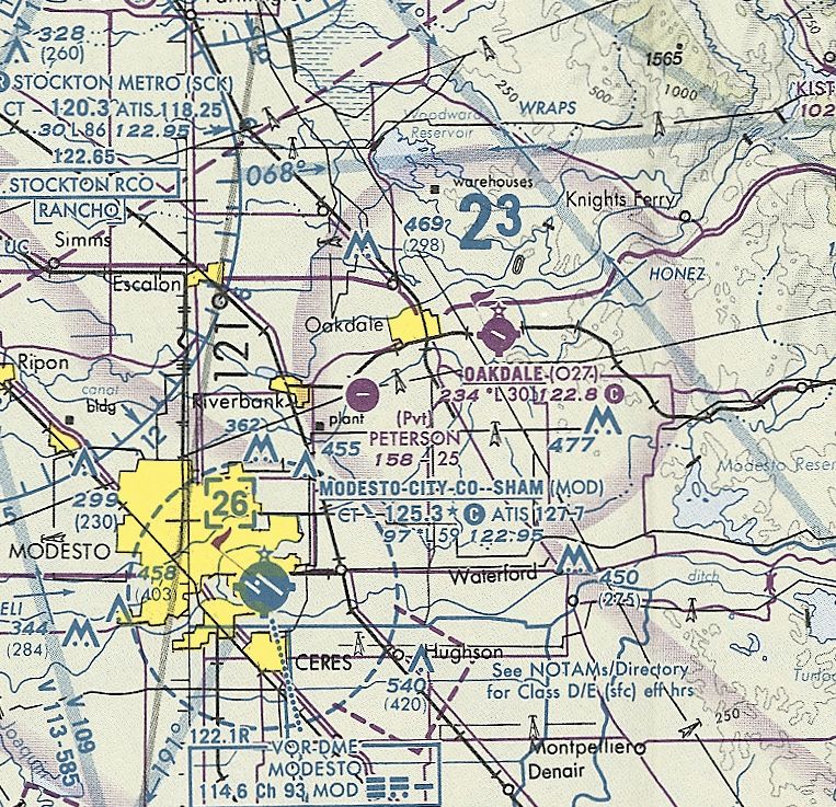
Abandoned & Little-Known Airfields:
California, Central Valley area
© 2002, © 2026 by Paul Freeman. Revised 7/10/26.
This site covers airfields in all 50 states: Click here for the site's main menu.
____________________________________________________
Please consider a financial contribution to support the continued growth & operation of this site.
For a 10th year, the CA pages of this website are sponsored by the California Pilots Association:
Crows Landing NALF (revised 3/15/26) - Davis Airport / Ridgecrest Airport (revised 5/15/26) – Drummond Hospital Airport (added 5/15/26) - Hawke Airfield / Peterson Airfield (added 1/11/25)
Mendota Airport / William Robert Johnston Municipal Airport (revised 5/17/26) - Patterson Airport (revised 7/10/26) - Santa Nella Airport (revised 7/20/24) - Vernalis NAAS (revised 8/5/19)
____________________________________________________
Davis Airport / Ridgecrest Airport (RDC), Ridgecrest, CA
35.61, -117.67 (Northeast of Los Angeles, CA)
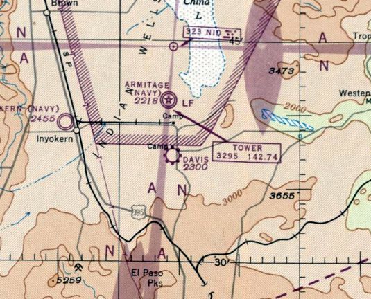
Davis Airport, as depicted on the September 1947 LA Sectional Chart.
This rural California airport was evidently established at some point in 1947,
as David Airport was not yet depicted on the February 1947 LA Sectional Sectional Chart.
The earliest depiction which has been located of Davis Airport was on the September 1947 LA Sectional Chart.
It depicted Davis as a commercial/municipal airport.
The earliest topo map depiction which has been located of this airport was on the 1947 USGS topo map.
It depicted Ridgecrest as a commercial/municipal airport.
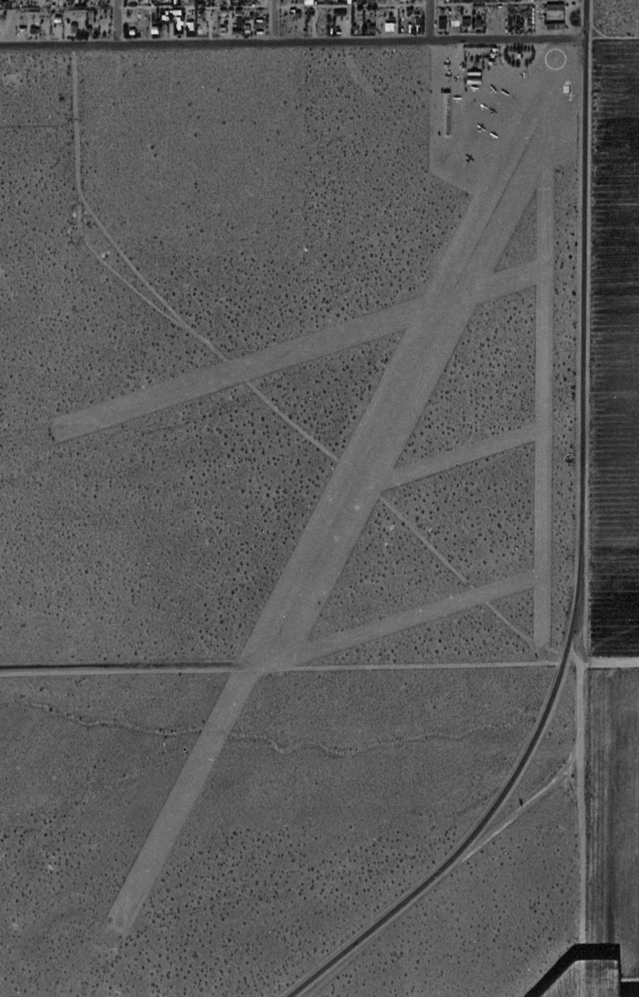
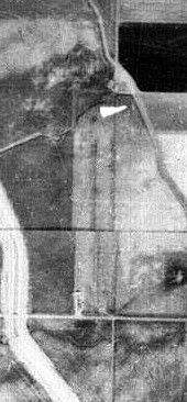
The only photo which has been located of Davis Airport was a 4/17/52 USGS aerial view.
It depicted Davis as having 2 unpaved runways, several taxiways, and a few small buildings & 8 light aircraft on the northeast side.
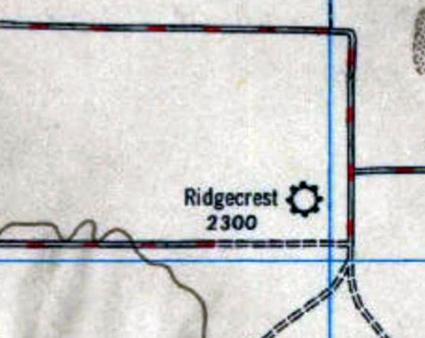
The 1953 USGS topo map depicted Davis Airport as having 2 runways, 2 taxiways, and a few small buildings on the northeast side.
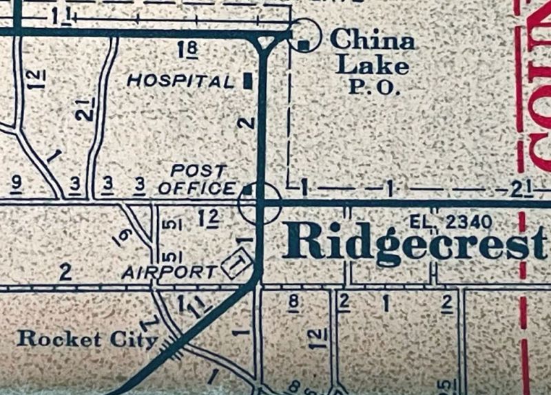
Davis Airport, as depicted on a 1953 road map (courtesy of Kevin Walsh).
A 1953 road map (courtesy of Kevin Walsh) depicted Ridgecrest Airport on the incorrect (southeast) side of the road.
Note that it also depicted the short-lived Drummond Hospital Airport only 2 miles north.
It was still depicted as Davis Airport on the March 1961 LA Sectional Chart.
Tim Vasquez reported, “Ridgecrest / Davis Airport... FAA identifier was RDC in 1963 & 1965.”
The last aeronautical chart depiction which has been located of this airport was on the March 1965 LA Sectional Chart.
It depicted Ridgecrest Airport as having a 2,700' unpaved runway.
Ridgecrest Airport was evidently closed (for reasons unknown) at some point in 1965,
as it was no longer depicted on the August 1965 LA Sectional Chart.
Tim Vasquez reported, “Ridgecrest / Davis Airport... FAA identifier RDC [was] deleted by 1969.”
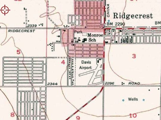
Aerial photos from 1972 & 1973 showed a housing development had been built over the northern portion of the Ridgecrest Airport site,
but one of the airport buildings remained standing on the northeast corner.
The last depiction which has been located of Davis Airport was on a 1978 road map (courtesy of Kevin Walsh),
by which point the airport site had been covered by houses for several years.
A 1984 aerial view showed several small motels had been built on the northeast corner, erasing the last trace of Ridgecrest Airport.
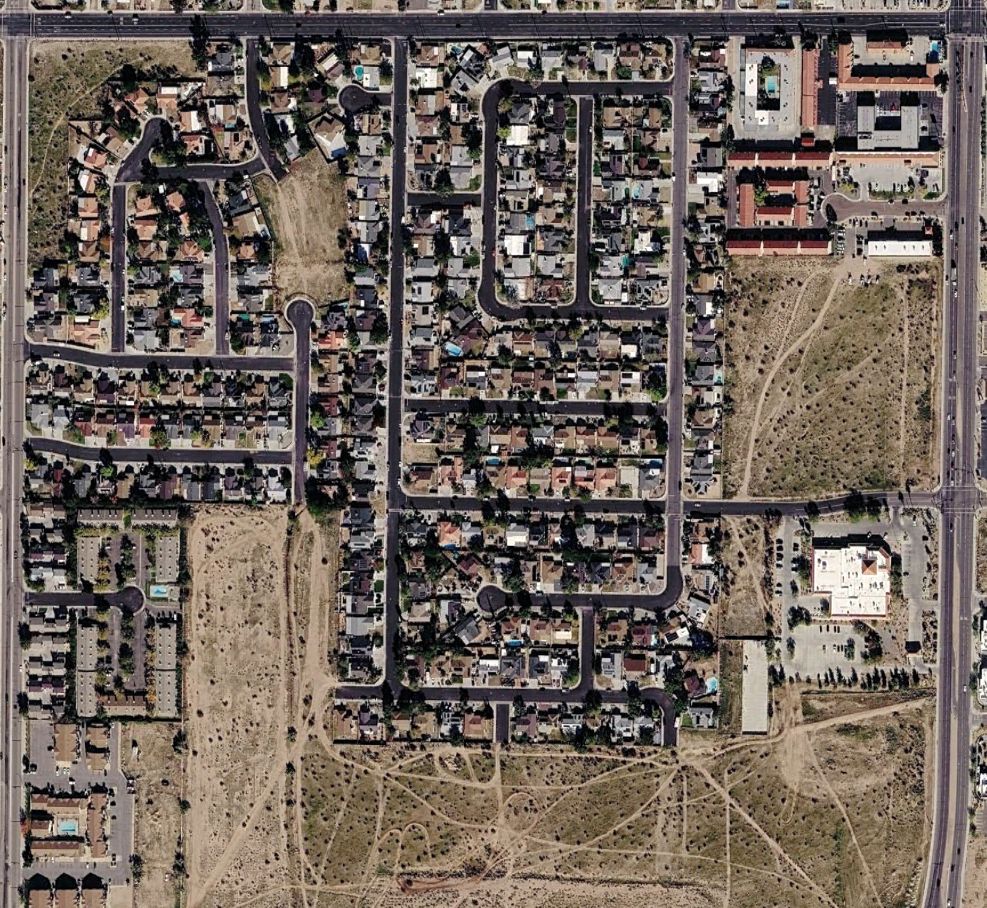
A 2025 aerial view showed no trace remaining of Ridgecrest Airport.
Thanks to Tim Vasquez for pointing out this airfield.
____________________________________________________
Drummond Hospital Airport, Ridgecrest, CA
35.641, -117.674 (Northeast of Los Angeles, CA)
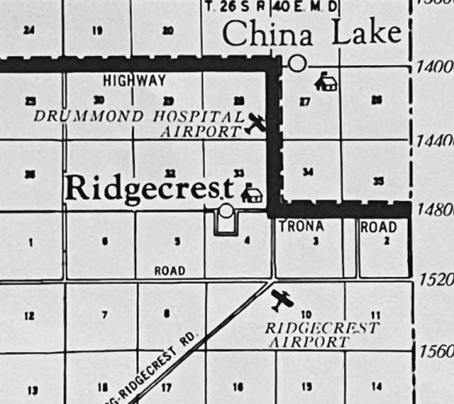
Drummond Hospital Airport, as depicted on a 4/17/52 USGS aerial view.
The date of establishment of this small airport attached to a hospital has not been determined.
Drummond Hospital Airport was not yet depicted on UGSS topo maps or LA Sectional Sectional Charts from the 1940s/50s/60s.
The earliest depiction which has been located of Drummond Hospital Airport was a 4/17/52 USGS aerial view (courtesy of Kevin Walsh).
It depicted Drummond Hospital Airport as having 2 unpaved runways on the southwest side of the hospital buildings, but there were no aircraft visible.
The only map depiction which has been located of Drummond Hospital Airport was on a 1953 road map (courtesy of Kevin Walsh).
Note that it also depicted Ridgecrest Airport only 2 miles south.
The 2 runways of Drummond Hospital Airport were still intact on a 1972 aerial photo, but did not appear to still be in use.
A 1984 aerial view showed houses had been built over the site of Drummond Hospital Airport.
A 2025 aerial view looking north showed no trace remaining of Drummond Hospital Airport.
Thanks to Kevin Walsh for pointing out this airfield.
____________________________________________________
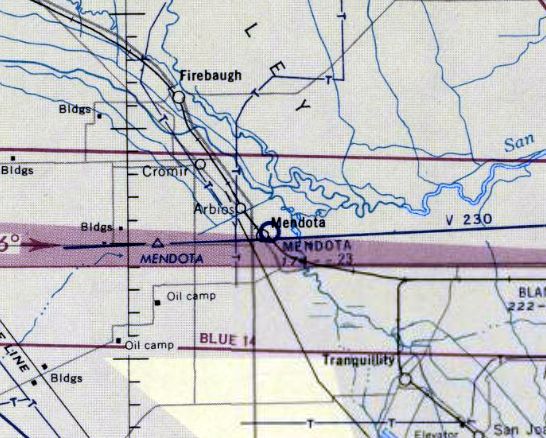
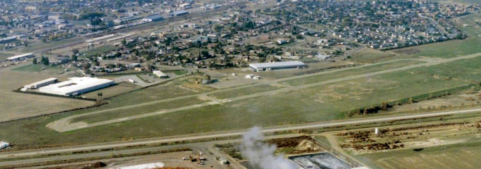
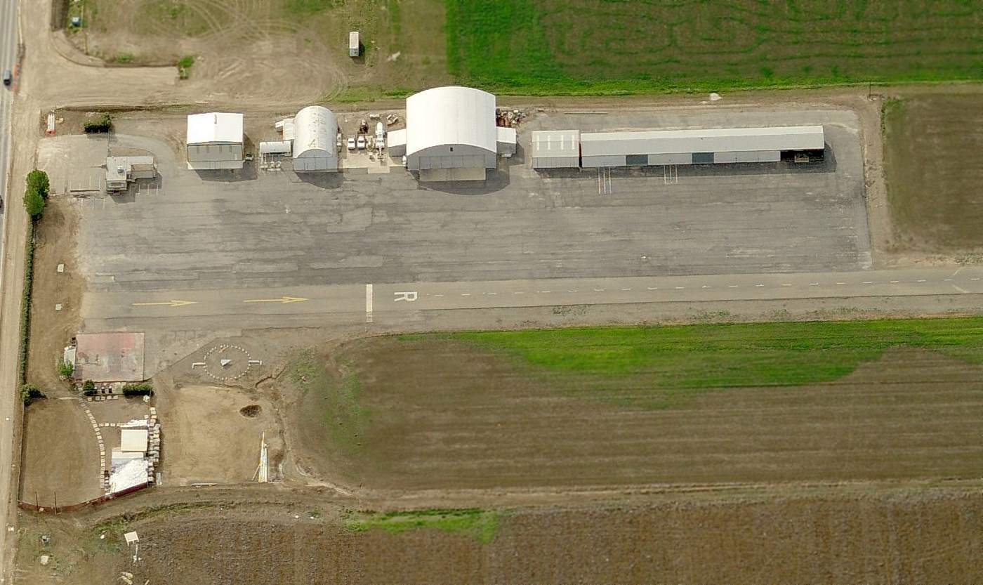
Mendota Airport / William Robert Johnston Municipal Airport (M90), Mendota, CA
36.76, -120.37 (East of Oakland, CA)
Mendota Airport, as depicted on a 6/15/57 USGS aerial view (courtesy of Kevin Walsh).
Mendota Airport was evidently constructed at some point between 1946-55, as it was not yet depicted on a 1945 aerial photo.
The earliest depiction which has been located of Mendota Airport was on a 1955 aerial view.
It depicted a single unpaved northwest/southeast runway, but there did not appear to be any hangars or airport buildings.
The earliest photo is available of Mendota Airport was a 5/15/57 USGS aerial view (courtesy of Kevin Walsh).
It depicted Mendota Airport as having a single northwest/southeast runway, but there did not appear to be any hangars or airport buildings.
According to its FAA Airport/Facility Directory data, Mendota Airport was activated in August 1957.
Mendota Airport was not yet depicted on the September 1957 San Francisco Sectional Chart.
The earliest aeronautical chart depiction which has been located of Mendota Airport was on the April 1958 San Francisco Sectional Chart.
It depicted Mendota Airport as having a 2,300' unpaved runway.
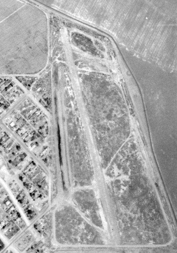
A 1965 USGS aerial view depicted Mendota Airport as having a single northwest/southeast runway, but there did not appear to be any hangars or airport buildings.
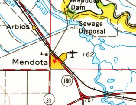
The earliest topo map depiction which has been located of Mendota Aiport was on the 1968 USGS topo map.
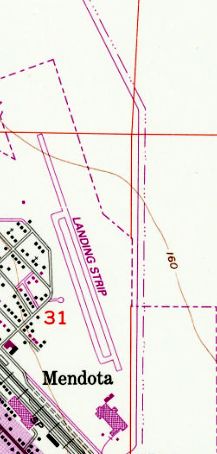
The 1984 USGS topo map depicted the Mendota Airport as a single paved northwest/southeast runway with a paved parallel taxiway on the west side, labeled generically as “Landing Strip”.
The earliest oblique view which has been located of Mendota Airport was a 2000 aerial view looking west.
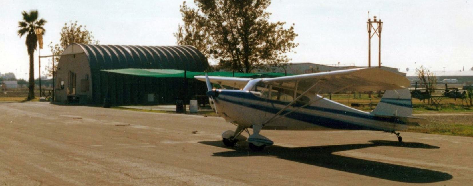
A 2001 photo of an Aeronca parked in front of the Mendota Airport Quonset Hut airport office.
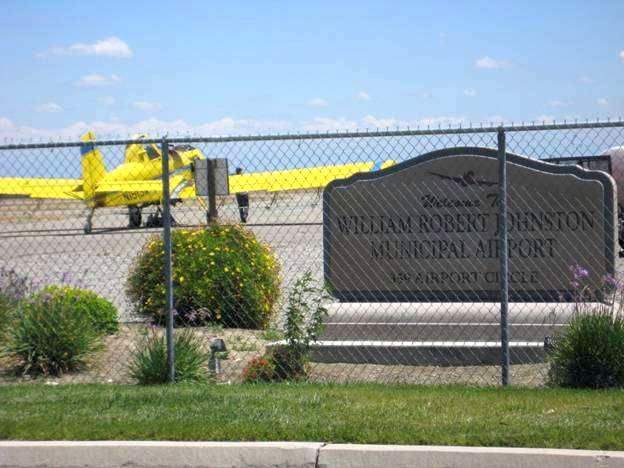
A pre-2022 photo of a cropduster & the William Robert Johnston Municipal Airport sign.
According to the City of Mendota website (courtesy of Jonathan Westerling), “The William Robert Johnston Municipal Airport was closed in October 2022.”
The reason for the airport's closure has not been determined.
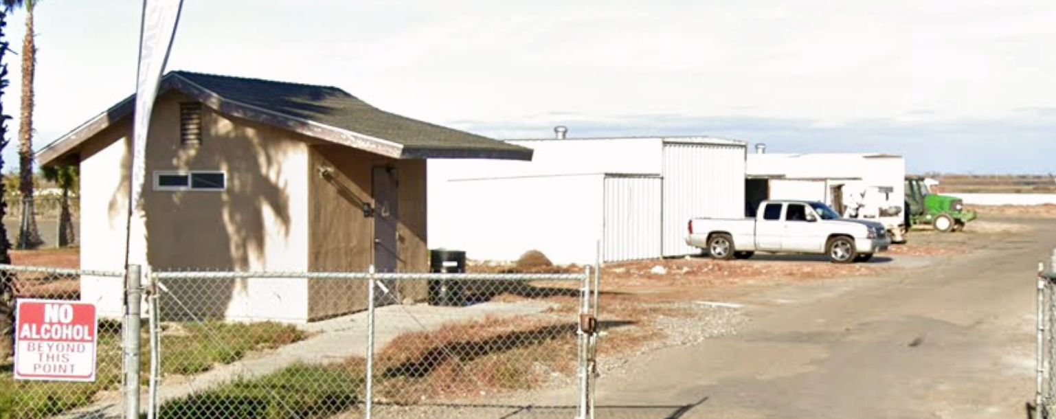
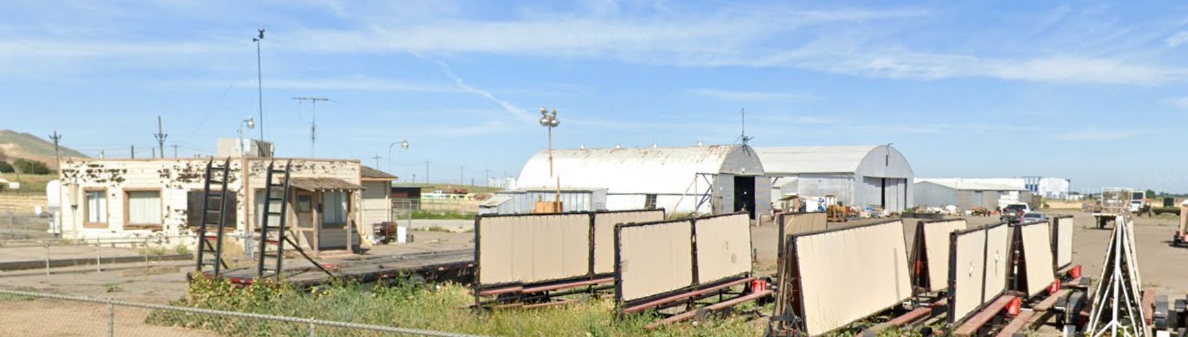
A 2025 photo of several former Johnston Airport hangars.
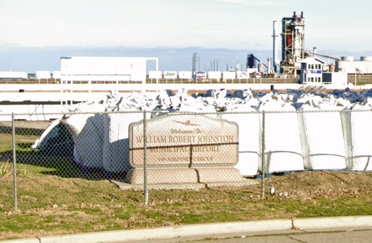
A 2025 photo of the William Robert Johnston Municipal Airport sign.
As of 2026, the FAA Airport/Facility Directory described Johnston Municipal Airport as having a single 3,499' asphalt Runway 15/33, “potholed with areas of collapsed pavement.”
It was described as being owned by the City of Mendota, and managed by Christian Gonzales, but to be closed indefinitely.
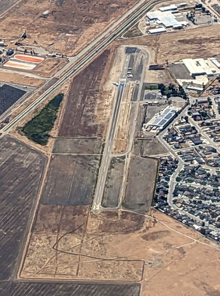
A 4/17/26 aerial view by Jonathan Westerling looking southeast at the former Johnston Airport.
Jonathan observed, “There's now a drag strip constructed at one end of the runway, so its reopening does not appear likely.”
Thanks to Jonathan Westerling for pointing out this airfield.
____________________________________________________
Hawke Airfield / Peterson Airfield, Modesto, CA
37.723, -120.89 (East of Oakland, CA)
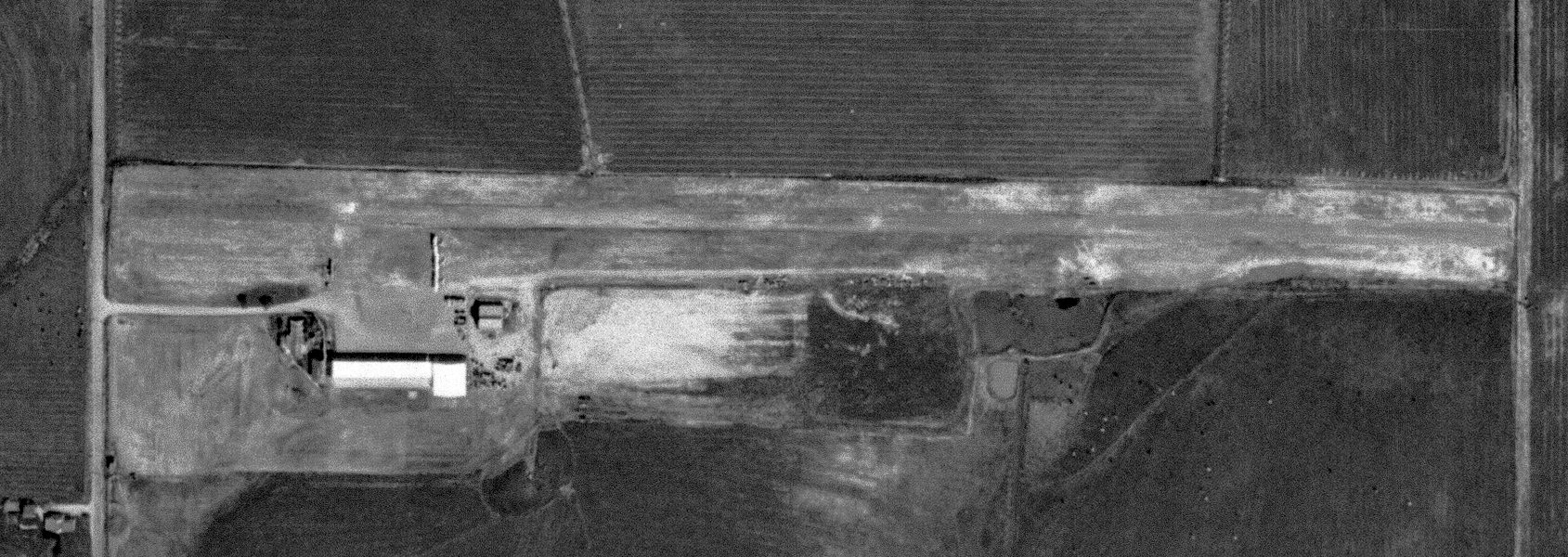
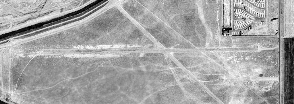
Hawke Airfield, as depicted on a 5/15/67 USGS aerial view.
This small agricultural airfield was evidently established at some point between 1957-67, as it was not yet depicted on a 1957 aerial view.
The earliest depiction which has been located of Hawke Airfield was on a 5/15/67 USGS aerial view.
It depicted Hawke Airfield as having a single east/est runway, on the south side of which were parked 3 single-engine biplanes near some small buildings.
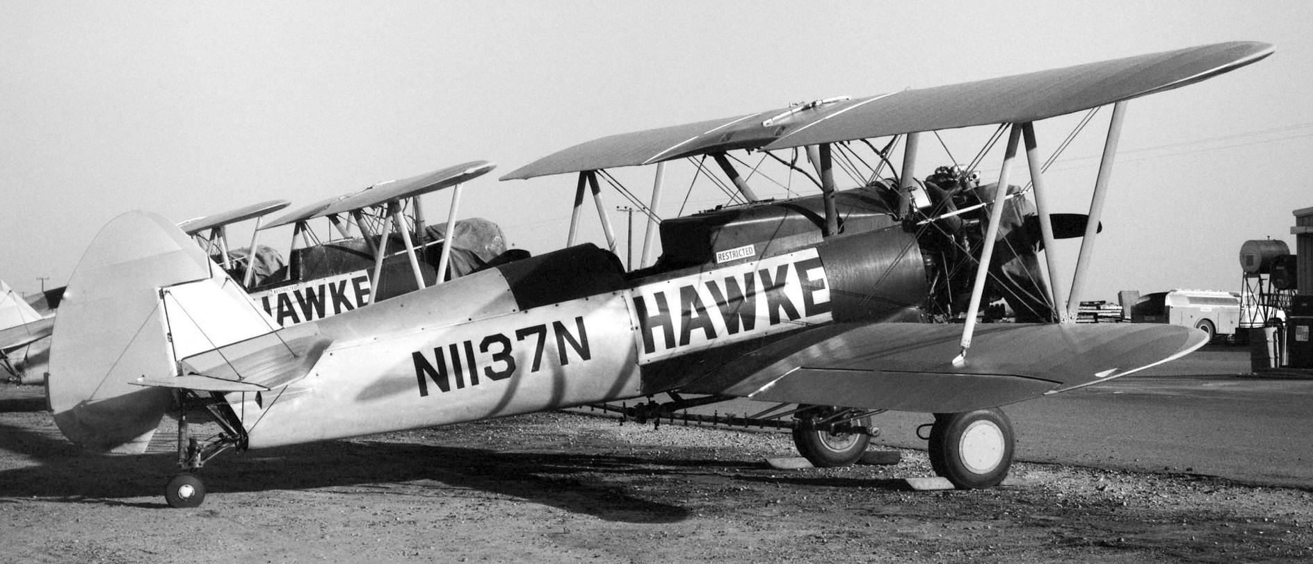
The earliest ground-level photo which has been located of Hawke Airfield was a October 1972 photo by Jay Sherlock of Boeing N2S-5 N1137N (ex-USN 61214) prominently painted in Hawke markings, along with 2 other Hawke N2Ss.
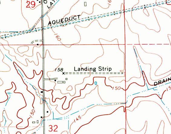
The earliest topo map depiction which has been located of Hawke Airfield was on the 1972 USGS topo map,
which depicted single east/west unpaved runway, labeled generically as “Landing Strip”, with several small buildings on the southwest side.
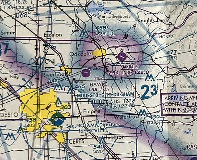
The earliest aeronautical chart depiction which has been located of Hawke Airfield was on the October 1988 San Francisco Sectional Chart.
It depicted Hawke as a private airfield having a single 2,500' paved east/west runway.
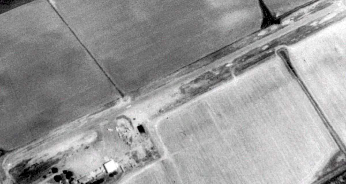
A 1993 USGS aerial view looking northeast depicted Hawke Airfield as having 3 aircraft parked on the field.
The 1995 USGS topo map depicted Hawke Airfield as an east/west unpaved runway, labeled generically as “Landing Strip”.
Hawke Airfield was evidently renamed Peterson at some point between 1989-97, as that is how it was labeled on the 1997 San Francisco Sectional Chart.
It depicted Peterson as a private airfield having a single 2,500' paved east/west runway.
The last photo which has been located showing aircraft at Hawke / Peterson Airfield was a 2002 aerial view looking northeast.
One yellow agricultural biplane & a smaller white single-engine plane were parked on the field, and the name “Hawke” was painted on the middle of the runway.
Peterson was evidently closed (for reasons unknown) at some point between 2002-2016, as it was no longer depicted on the 2016 San Francisco Sectional Chart.
Hawke Ag Aviation was listed in a 2020 California agricultural aviation operators listing (according to Jay Sherlock).
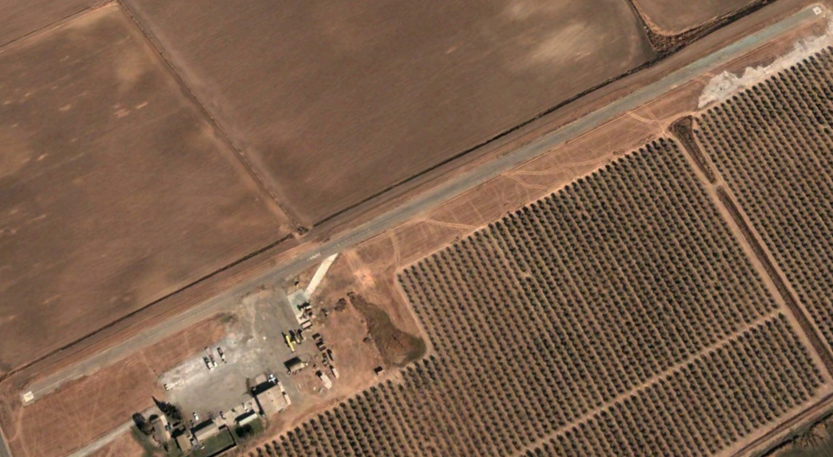
A 2023 aerial view looking northeast showed the Hawke / Peterson Airfield runway had been covered by orchard trees at some point between 2002-2023, although the former hangar remained standing.
Thanks to Jay Sherlock for pointing out this airfield.
____________________________________________________
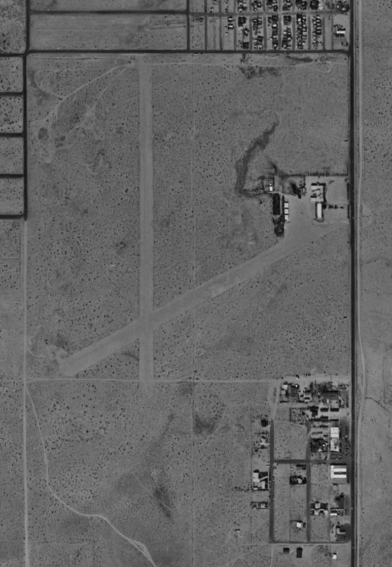
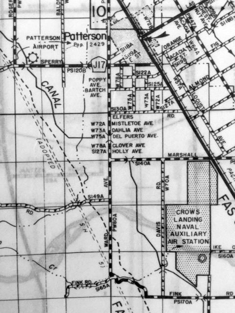
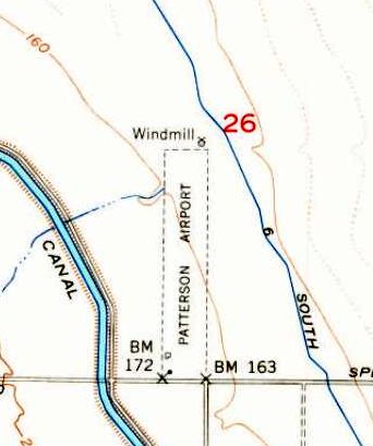
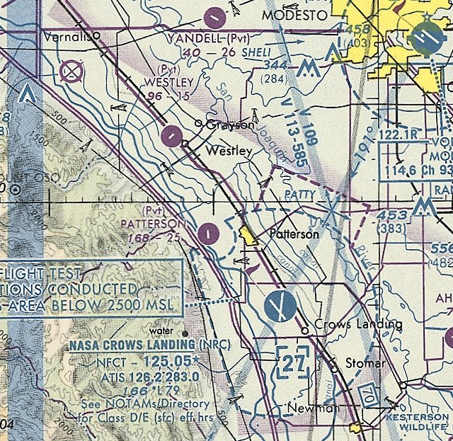
Patterson Airport, Patterson, CA
37.467, -121.17 (East of San Jose, CA)
Patterson Airport, as depicted on the August 1948 San Francisco Sectional Chart.
This small private airfield may have been established at some point between 1947-48,
as it was not yet depicted on the February 1945 Regional Aeronautical Chart (courtesy of Kevin Walsh) or the 1947 USGS topo map.
The earliest depiction which has been located of Patterson Airport was on the August 1948 San Francisco Sectional Chart,
which depicted Patterson as having a 2,600' unpaved runway.
The earliest photo which has been located of Patterson Airport was a 1950 aerial view (courtesy of Jonathan Westerling),
which depicted Patterson as having a single north/south runway, with a few small buildings on the southwest side.
Patterson Airport, as depicted on a 1952 CA Highways map (courtesy of Kevin Walsh).
The earliest topo map depiction which has been located of Patterson Airport was on the 1953 USGS topo map,
which depicted Patterson as having a single north/south unpaved runway, with 2 small buildings on the southwest side.
A 1957 aerial view (courtesy of Jonathan Westerling) depicted Patterson as having a single north/south runway, with a few small buildings on the southwest side.
The 1961 San Francisco Sectional Chart described Patterson Airport as having an asphalt runway.
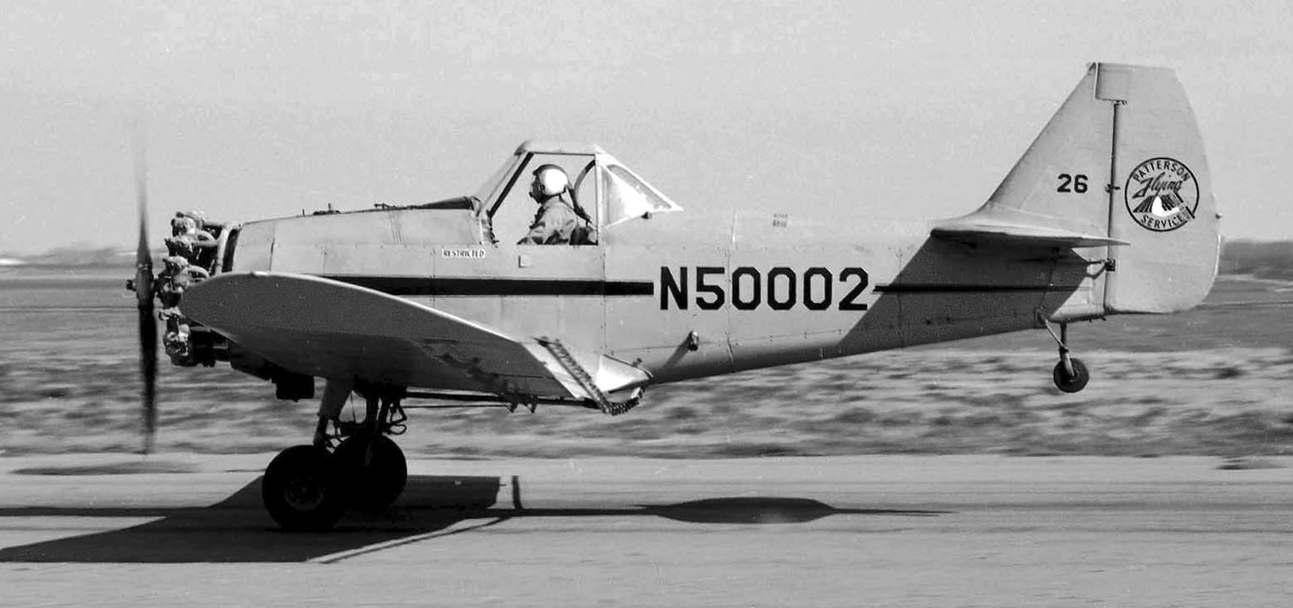
The earliest ground-level photo which has been located showing an aircraft at Patterson Airport was a February 1966 photo by Bill Larkins of Patterson Flying Service Weatherly WM-62C N50002 taking off.
The WM-62 was one of 19 which were converted from surplus Fairchild PT-19A trainers into single-seat cropdusters.
The 1965 San Francisco Sectional Chart depicted Patterson Airport as having a single 1,800' paved north/south runway.
The 1966 San Francisco Sectional Chart depicted Patterson Airport as having a single 1,800' paved north/south runway.
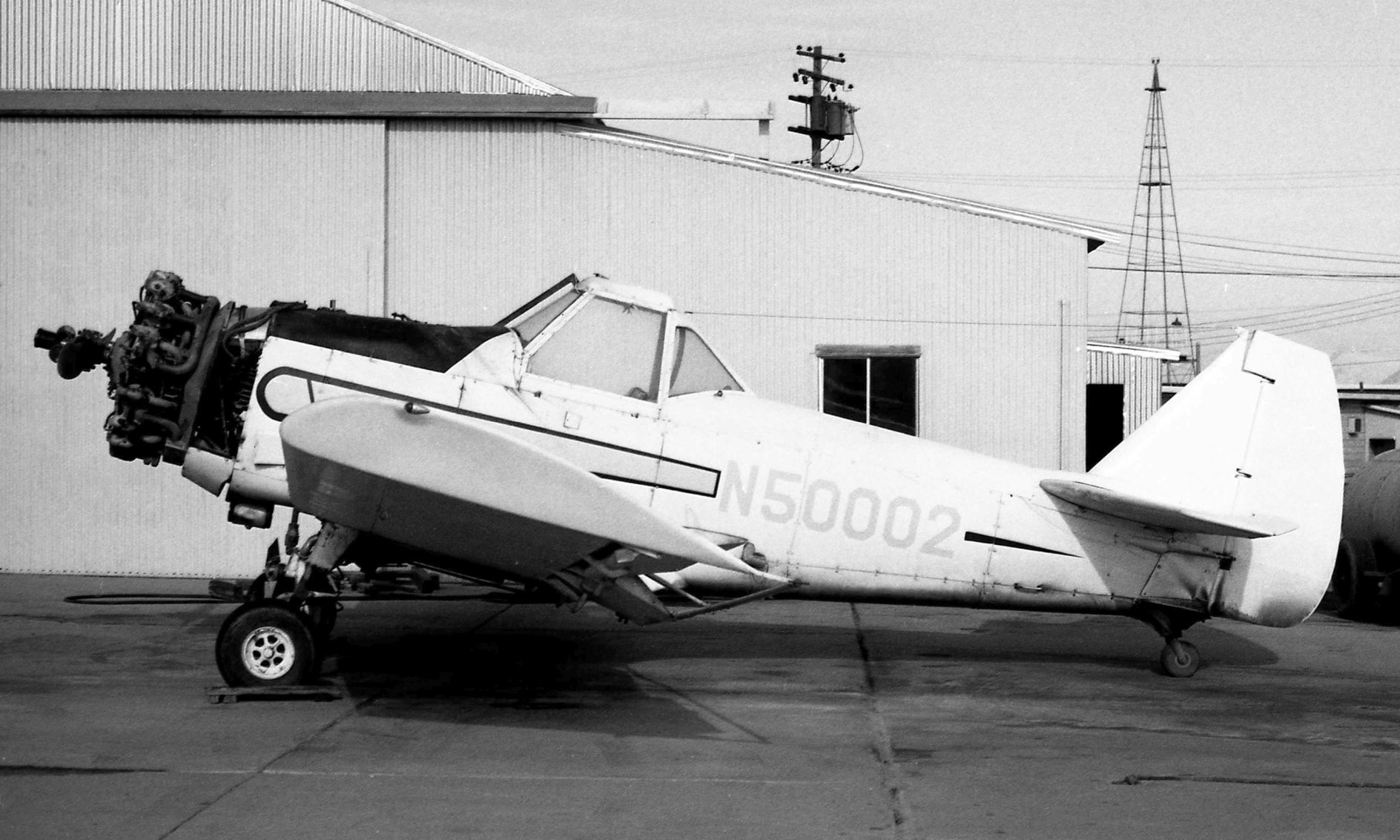
The last ground-level photo which has been located showing an aircraft at Patterson Airport was a December 1970 photo by John Stewart of Patterson Flying Service Weatherly WM-62C N50002 in front of a hangar.
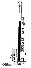
A 1977 airport directory (courtesy of Jonathan Westerling) depicted Patterson as having a single 2,505' paved Runway 16/34, with an office & a few small buildings on the southwest side.
The last aeronautical chart depiction which has been located of Patterson Airport
was on the September 1997 San Francisco Sectional Chart (courtesy of Ron Plante).
It depicted Patterson Airport as a private airfield having a 2,500' paved north/south runway.
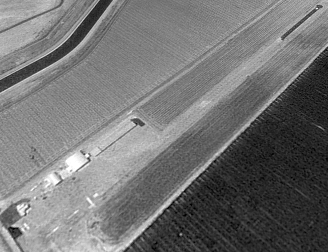
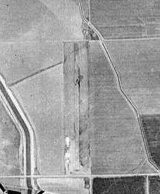
A 1998 aerial view looking northwest depicted Patterson Airport as having a single paved runway.
One aircraft was visible parked near the hangars on the southwest side.
The last photo which has been located showing an aircraft at Patterson Airport was a 2004 aerial view looking northwest, which showed 1 aircraft parked near the hangars on the southwest side.
A proposed business park proposed for the Patterson Airport site in 2010, as described in an article (courtesy of Jonathan Westerling), did not get built.
A circa 2011 aerial view looking west showed Patterson Airport remaining intact, and still marked with active runway markings.
A 5/19/12 aerial photo still showed Patterson Airport's runway marked as an active runway.
Patterson Airport was evidently closed within the next few months, as an 8/23/12 aerial photo showed the runway markings had been painted over.
According to a 2013 city council report (courtesy of Jonathan Westerling), Patterson Airport was closed.
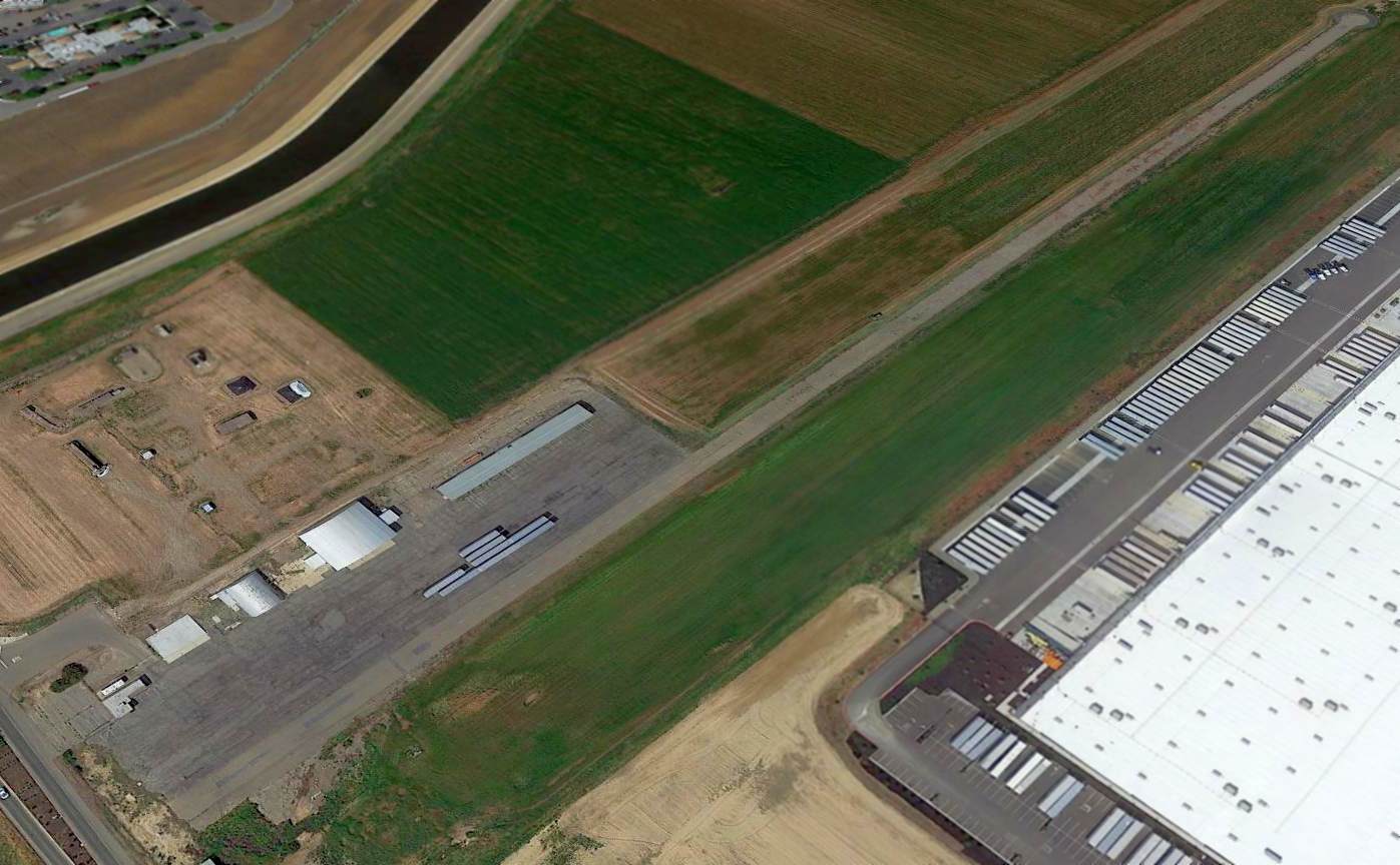
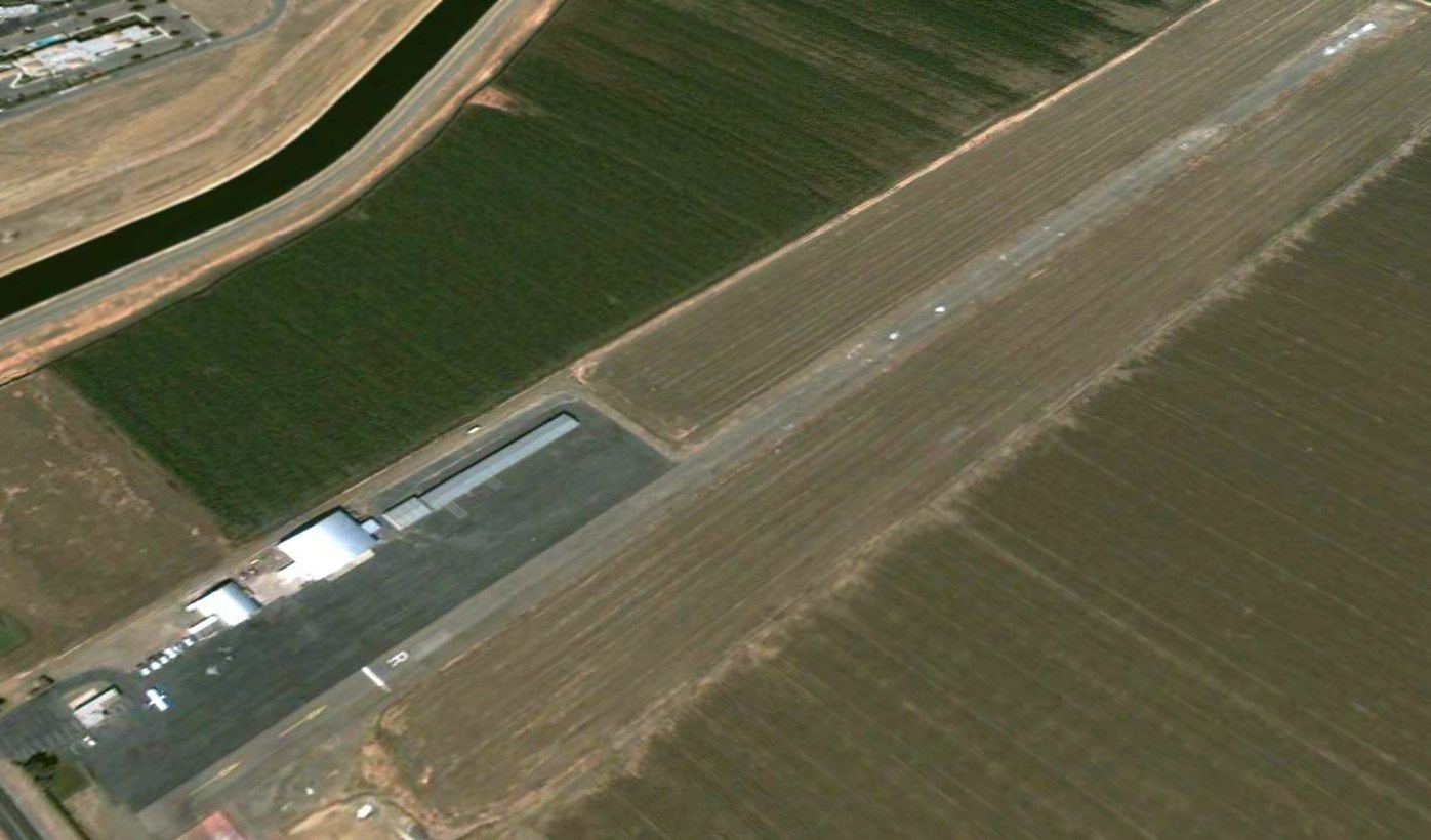
A 2015 aerial view looking northwest showed Patterson Airport remaining intact though abandoned.
What a shame to see such a nice little general aviation airport go completely unused for years.
Jonathan Westerling observed in 2015, “Ironic that it's adjacent to huge CVS & Amazon fulfillment centers who could use the airport for expedited delivery around the bay area.”
A 4/4/17 photo by Jonathan Westerling looking northwest at the hangars of Patterson Airport.
Jonathan observed, “With all the houses & industry around, it doesn't seem to make sense that this little airport would close.
It looks like it had a pretty healthy life decades ago, however.”
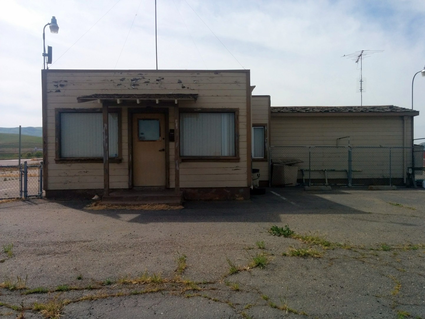
A 4/4/17 photo by Jonathan Westerling looking at the former Patterson Airport office building,
A 4/4/17 photo by Jonathan Westerling looking north along the former Patterson Airport runway, with the huge CVS & Amazon fulfillment centers looming in the background.
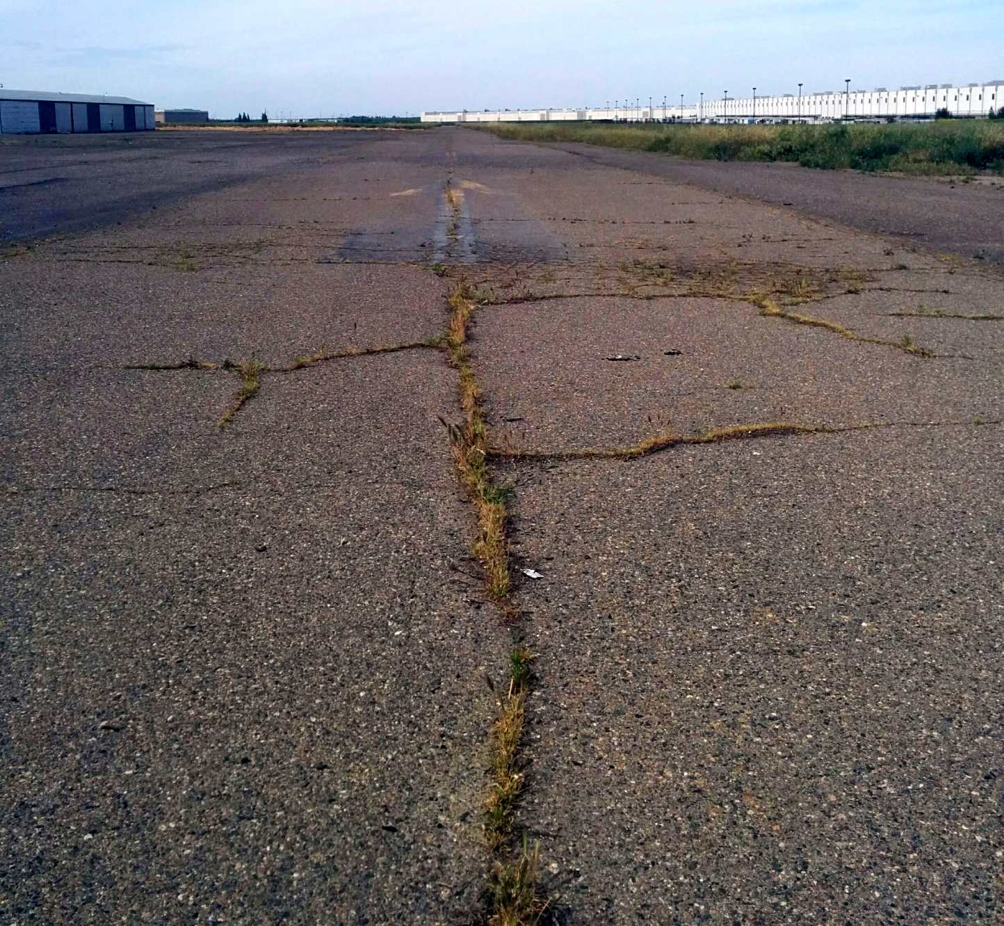
A 2026 photo looking northwest at the former Patterson Airport office building & hangars.
Patterson Airport is located northwest of the intersection of Sperry Avenue & Park Center Drive.
Thanks to Jonathan Westerling for pointing out this airfield.
____________________________________________________
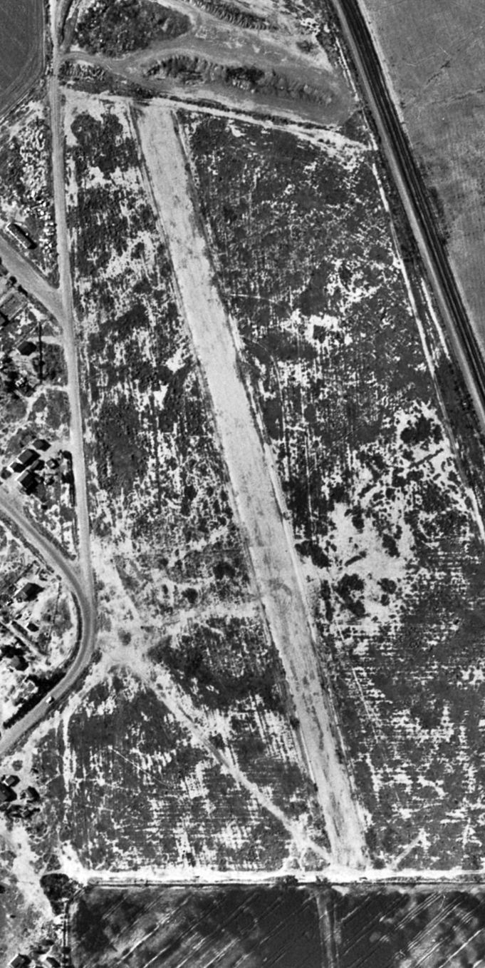
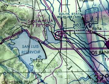
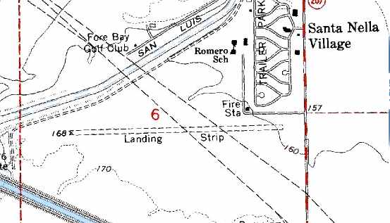
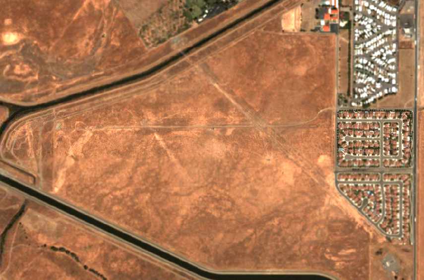
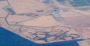
Santa Nella Airport, Santa Nella Village, CA
37.093, -121.024 (Southeast of San Jose, CA)
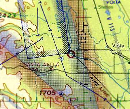
Santa Nella Airport, as depicted on the June 1963 San Francisco Sectional Chart (courtesy of Chris Kennedy).
The Santa Nella Airport was built at some point in between 1960-63, as it was not yet depicted on the 1953 USGS topo map
nor on the September 1960 San Francisco Sectional Chart.
The earliest depiction which has been located of Santa Nella Airport was on the June 1963 San Francisco Sectional Chart (courtesy of Chris Kennedy).
It depicted Santa Nella as a public-use airport having a 3,800' unpaved runway.
The Santa Nella Airport was located just south of a small subdivision called Santa Nella Village.
The airport was located directly at the base of the 88 foot high O’Neill Dam,
which was finished in 1967 to capture mountain runoff to irrigate the crops of California’s prospering Central Valley.
The 1967 APOA Airports USA directory (according to Jonathan Westerling)
described Santa Nella as being a public airport with a single 4,000' oiled dirt Runway 7/25.
The operator was listed as Gerald Hoyt.
The only photo which has been located showing Santa Nella Airport during the period it was operational was a 8/31/67 USGS aerial view.
It depicted a single east/west runway, but there were no aircraft, hangars, or other signs of recent aviation usage.
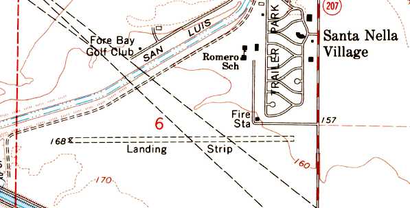
The 1969 USGS topo map depicted Santa Nella's single runway, but labeled simply as “Landing Strip”.
The 1973 San Francisco Sectional Chart (courtesy of Jonathan Westerling)
depicted Santa Nella as a public-use airport, having a 4,000' unpaved runway.
An interesting reference to the Santa Nella Airport can be found as part of a 1979 Lawsuit (courtesy of Jonathan Westerling).
It said, “On 6/4/74, Edward Golde landed a small airplane at the Santa Nella Airport in Merced County.
He had a certified private pilot's license.
The plane contained 800 to 1,000 pounds of marijuana with an agreed street value of $256,000.
He had obtained the marijuana in Mexico.
It would appear the airplane ran out of gasoline, the pilot having overrun his rendezvous point.”
NTSB records listed activities at Santa Nella Airport through 1977 (according to Jonathan Westerling).
By 1980 the Guide to California Airports & Flight Guide (according to Jonathan Westerling)
listed Santa Nella as a “private” airport, with parachuting operations on the weekends.
The 1981 San Francisco Sectional Chart (courtesy of Jonathan Westerling)
depicted Santa Nella as a private field having a 4,000' unpaved runway.
A June 1987 aerial photo (from the UCSB Library) depicted the Santa Nella runway as remaining intact,
but without any sign of recent aviation use.
The 1991 USGS topo map depicted Santa Nella's single runway, but labeled simply as “Landing Strip”.
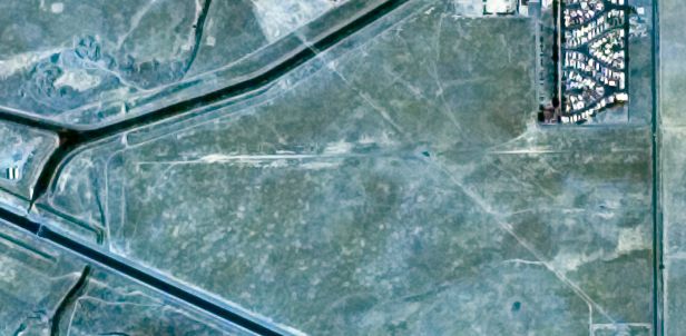
Santa Nella Airport was definitely closed by 1993,
as it was no longer depicted at all on the 1993 San Francisco Sectional Chart (according to Jonathan Westerling).
A circa 2001-2005 USGS aerial photo of the site of the Santa Nella airfield
showed that the Santa Nella Village housing development to the northeast of the field had expanded to the south,
covering the eastern end of the former runway.
A 2005 aerial photo by Jonathan Westerling looking northeast at the site of the Santa Nella Airfield.
A 2006 aerial view showed majority of the Santa Nella Airport site remained clear.
A 2009 aerial photo showed streets for an expanded housing development being built over the middle of the Santa Nella Airport site.
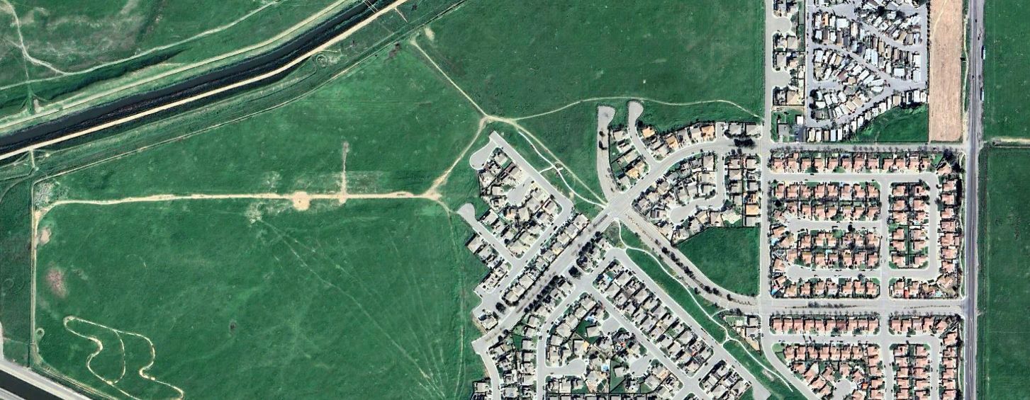
A 2024 aerial photo showed remains of the western end of the Santa Nella Airfield remained recognizable.
The site of Santa Nella Airport is located west of the intersection of Centinelia Drive & Santa Nella Road.
____________________________________________________
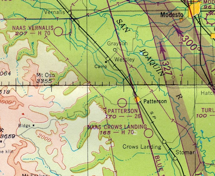
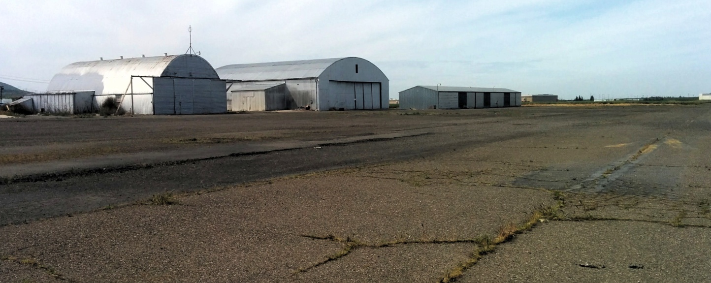
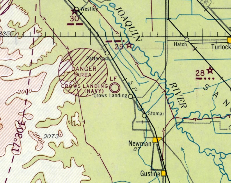
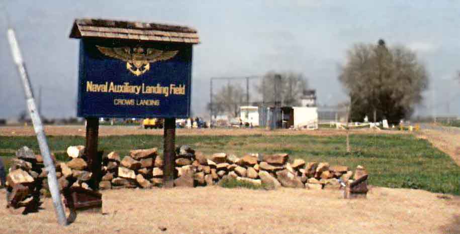
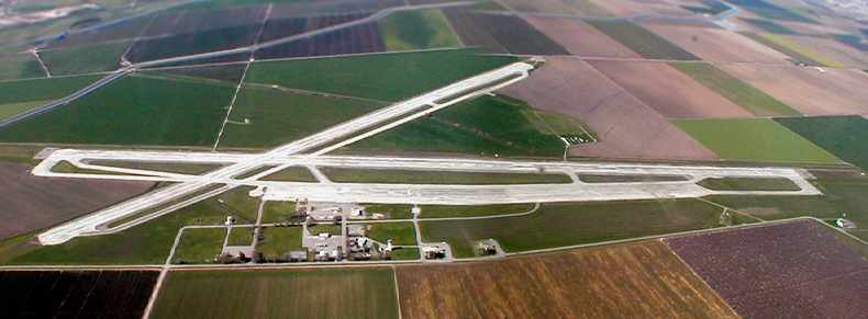
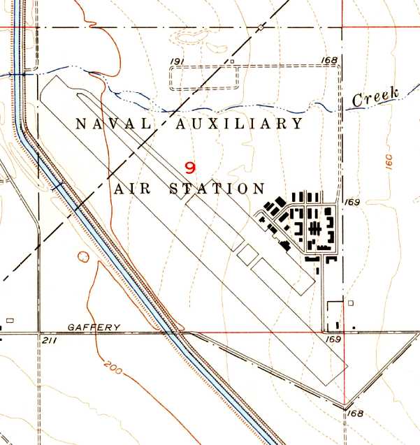
Crows Landing Naval Auxiliary Landing Field (NRC / CA93), Patterson, CA
37.41, -121.11 (East of San Francisco, CA)
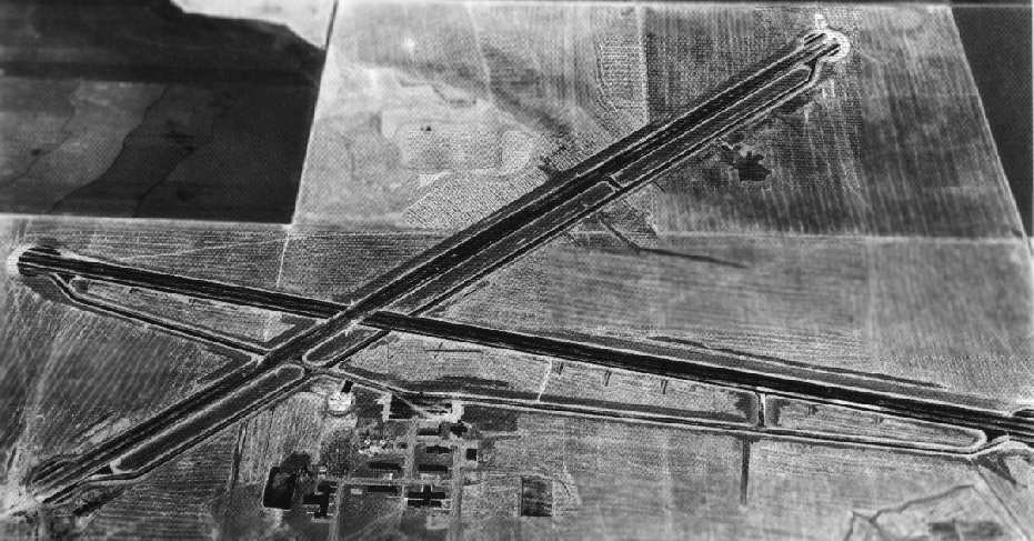
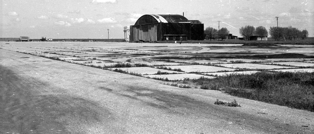
A 1943 National Archives aerial view looking west at Crows Landing.
Crows Landing was not yet depicted on the August 1942 Aeronautical Chart.
This airfield was built in 1942 as a satellite airfield for Alameda NAS.
The earliest depiction which has been located of the Crows Landing airfield was a 1943 National Archives aerial view,
which depicted the field as having 2 paved runways, taxiways, ramps, and several buildings.
The facilities at Crows Landing were complemented by nearby bombing & gunnery ranges.
The earliest aeronautical chart depiction which has been located of the Crows Landing airfield was on the August 1943 San Francisco Sectional Chart.
A 8/5/44 aerial view of Crows Landing NAAS from the 1945 AAF Airfield Directory (courtesy of Scott Murdock)
depicted the field in much the same manner as the 1943 photo.
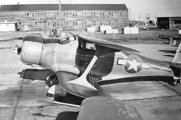
A 1944 photo by Wayne Hilton of a Beechcraft GB Traveller at Crows Landing.
Wayne recalled, “This airplane belonged to the station - not a squadron.
It was used for spotting good duck shooting locations mostly.
We had some nice ship's company aircraft & lots of emergency vehicles - all of which had radios needing attention.”
Wayne Hilton recalled being stationed at Crows Landing during WW2:
“I was an Aviation Radio Technician 2nd class there at NAS Crows Landing.
I got in the war late & the high-timers went home so their was a huge void for a tech
to take care of the airplane & tower radios there at Crows Landing.
The job called for a chief radio tech but it was my fate to fill in.
Much responsibility but I had been a radio amateur for long time so had no problems.
Most aviation bases were pretty lax on formality so duty was OK.
I got liberty on some weekends. Of course the nearest liberty town was Modesto - 20 miles distant.
I fixed everyones' car radios etc so I was treated very well. I got extra food, etc.
It was a good duty station. If you did your job you were not bothered. Few inspections, etc.”
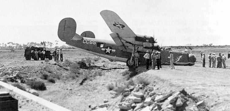
A Patrol Bombing Squadron (VPB) 122 Consolidated PB4Y-1 (Buno 59361)
swerved off the Crows Landing runway during a crosswind landing & ended up in a ditch on April 1, 1945.
The 1945 AAF Airfield Directory (courtesy of Scott Murdock) described Crows Landing NAAS
as a 680 acre cross-shaped property containing 2 concrete 7,000' runways, oriented north/south & northwest/southeast.
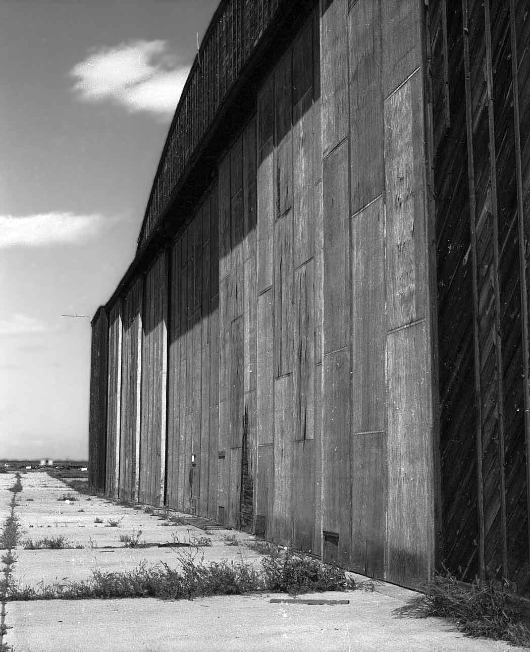
The field was said to have a single 125' x 60' wood nose hangar, and 2 additional hangars under construction.
Crows Landing was described as being owned by the U.S. Government, and operated by the Navy.
The Crows Landing airfield was reduced to caretaker status in 1946.
A 1947 Navy aerial photo looking north at Crows Landing.
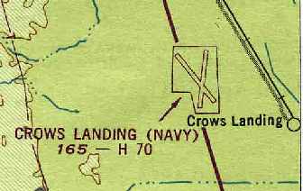
"Crows Landing (Navy)" was depicted on the 1949 San Francisco Local Aeronautical Chart (courtesy of Chris Kennedy)
as having 2 paved runways, with the longest being 7,000'.
“Crows Landing Naval Auxiliary Air Station”, as depicted on a 1952 CA Highways map (courtesy of Kevin Walsh).
The 1952 USGS topo map depicted Crows Landing “Naval Auxiliary Landing Field”
as having 2 paved runways, taxiways, ramps, streets, and several buildings.
"Crows Landing ALF" was still depicted as a military airfield on the 1955 & 1956 San Francisco Sectional Charts (according to Chris Kennedy).
The aerodromes table on the charts described the field as having 2 runways, with the longest being a 7,000' concrete strip.
The remarks said, "Official business only, Unattended. ALF to NAS Moffett."
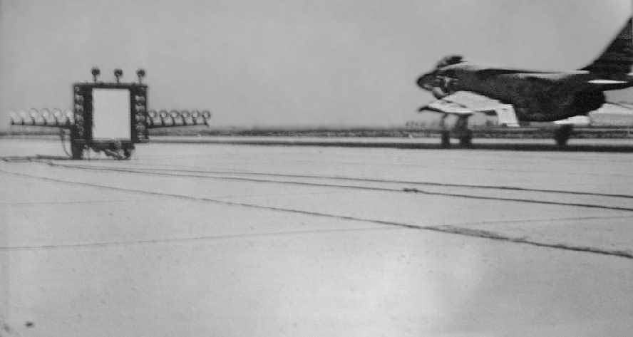
A circa 1950s photo (courtesy of Rex Ricks) showing a Navy F3H Demon landing next to a fresnel lens landing aid at Crows Landing.
The caption read, “Crow's Landing is an auxiliary training field 48 miles east of Moffett where carrier squadrons from Moffett & Alameda
simulate carrier takeoff & landing, using unique 'mirror' device.”
A 3/23/57 aerial view depicted Crows Landing Naval Auxiliary Landing Field as having 2 paved runways, taxiways, ramps, streets, and several buildings.
No aircraft were visible on the field.
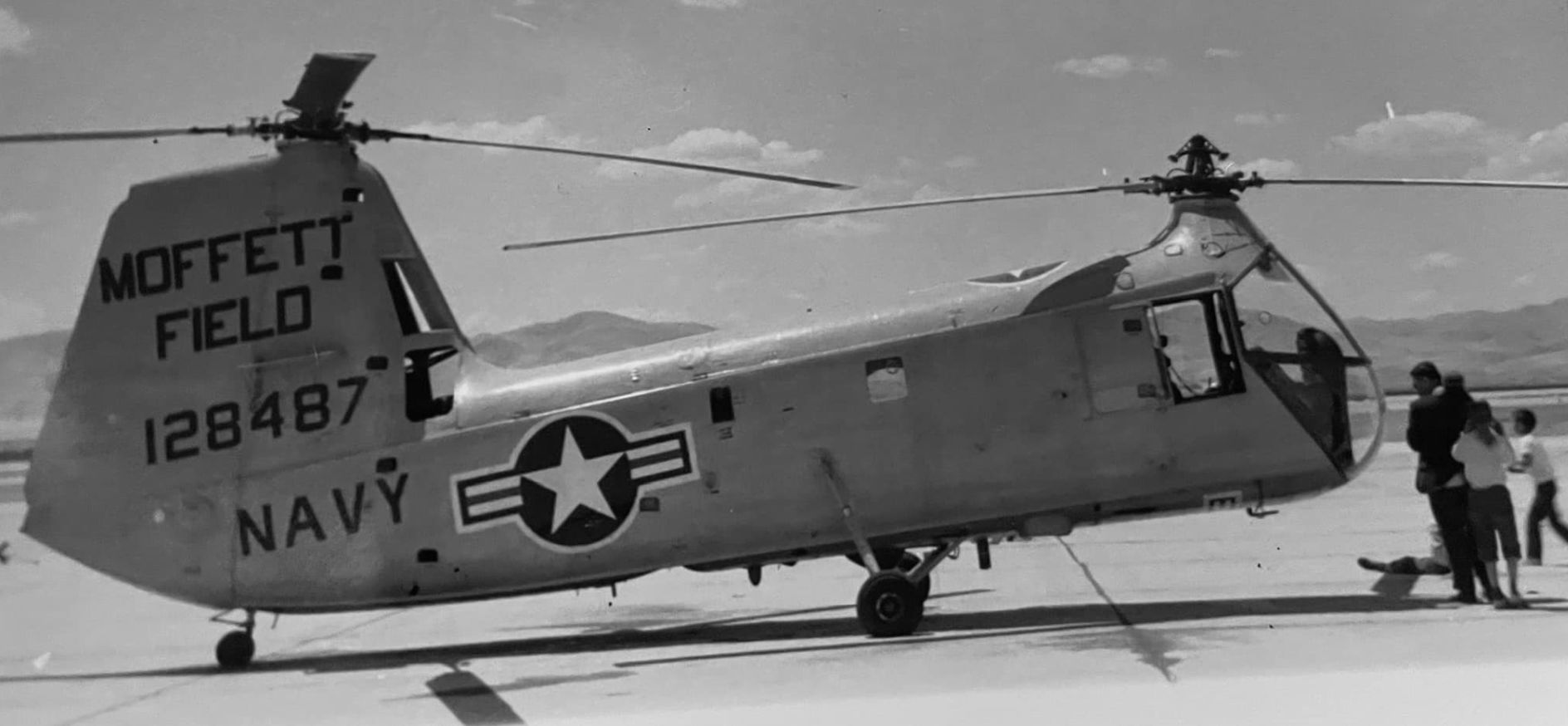
A July 1960 photo of a Navy Piasecki UH-25B Retriever tandem rotor helicopter from Moffet Field at Crows Landing.
Richard Hector recalled of Crows Landing in the 1960s, "I can remember as a school child taking tours of the base,
and once the famed Blue Angels performed there.
My understanding was that it was a convenient location
given the practice bombing range that existed for many years in the mountains just to the west of that base.
Just a single macabre anecdote: a long-time resident of Patterson
would sneak onto the bombing range & would retrieve unexploded ordnance.
He would dismantle them & sell the metal for scrap.
One day he mishandled one of the bombs & that was the end of Mr. Boschi."
Crows Landing was still listed as an "ALF to NAS Moffett"
on the 1965 San Francisco Sectional Chart (courtesy of Chris Kennedy).
Walter Ward recalled, “My father (Walter Francis Ward) was the Officer in Charge at Crow’s in the mid-1960s.
I have many fond memories of Crow’s Landing (in particular the Crow’s Nest) the tower & fire station & the old administration buildings.
A sailor taught me how to swim in the pool there. Many, many fond memories of exploring the place & discovering all sorts of interesting things.
I was just a kid at that time (I turned 10 in 1965) but it was a blast & seemed to me to be the Center of the Known Universe. It was fantastic!”
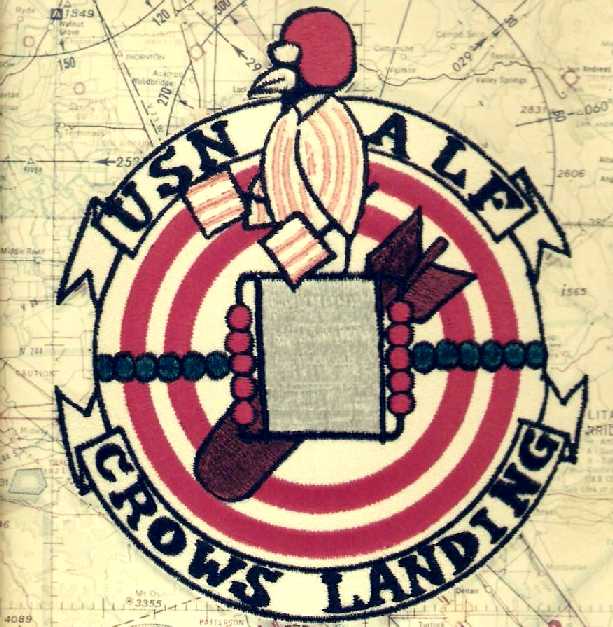
A Crows Landing patch (courtesy of Mike Roe, who was stationed there from 1967-68).
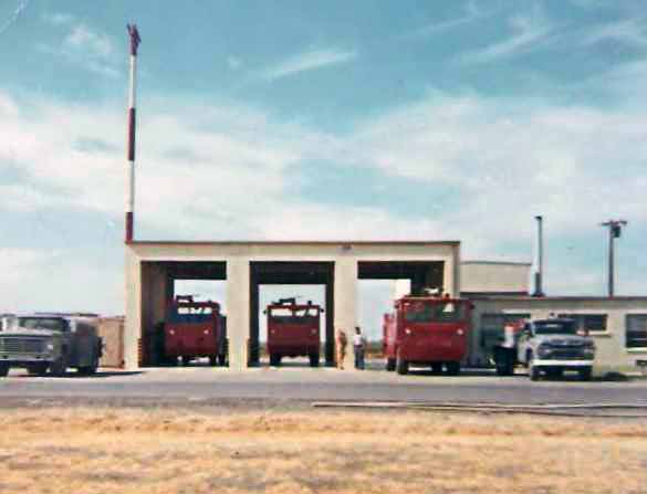
A 1967 photo by Mike Roe of the Crows Landing fire station.
Mike recalled, “Crows Landing was my first duty station after boot camp.
I got there in July of 1967 & was transferred to NAS Lemoore in April 1968.
My first task was selling beer at the CanAm race we put on in 1967. I was still attached to 1st Lt Div at that time.
Then I became a fire truck driver. The Navy Exchange was built by all hands with money earned by selling the beer at the race.
The building itself was made of 2 ammunition bunkers, quonset hut types, attached at the top.
Gas at the exchange pump was 0.2799 per gallon.”
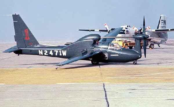
A circa 1967-68 photo of an experimental Lockheed QT-2PC at Crows Landing,
with a Navy S-2F in the background.
In 1967-68, Crows Landing was the site of flight tests & training of the highly-secret Lockheed QT-2PC,
which had been created under Operation Prize Crew to develop a quiet reconnaissance aircraft.
The experimental QT-2 aircraft, although never intended for tactical use,
were modified in only 87 days to the QT-2PC configuration,
and shortly thereafter were transported to Viet Nam for operational use.
Mike Roe recalled, “I was on the hardstand when that little experimental job [the QT-2PC] came out for testing.
He left & said he would be back in an hour or so. Three hours later there was still no sign of him.
We found the pilot asleep in the line shack. He snuck back in, parked himself, and waited for us to go looking for him.”
Howard Gillins recalled, “I was at Crows Landing from 5/68 to 6/70.
I was assigned to the Crash Fire Rescue Dept under civilian Fire Chief Walt Latham.
We had 1 SAR helo assigned at Crows Landing: an H-34 & later an H-2.
We had at that time 50 enlisted ( 5 CPO including LCPO) 1 OIC (Lcdr) & 5 civilians.
We built & occupied the Club / Rec Center / Ship Store.
We provided daytime touch & go practices for the military aircraft & at night carrier landing practices.
We supported the LSO, hot refueling & minor maintenance & repairs.
We mostly supported A-3, A-4, A-7, P-3 aircraft but were subject to any & all military aircraft.
I lived in Patterson. All the military & civilians lived in the surrounding communities (Patterson, Crows Landing, Newman).
We used the medical / dental & commissary services of Castle AFB.
We received extra pay because housing & messing was not afforded at Crows Landing.
We obtained odd jobs hired by local farmers to supplement our pay.
It was a really nice place to work & live.
We had numerous NAVAIR planes flying to us for ops because nobody complained.
It was a great duty station in a fun aviation era.”
Crows Landing, as depicted on the 1971 DoD Instrument Approach Procedures (courtesy of Chris Kennedy).
Bud Bondietti recalled, "I was stationed at NALF Crows Landing from 9/71-4/74.
My rating was Aviation Ordnance & I was assigned to the line crew & back-up target range personnel."
A 9/21/76 NASA aerial view looking northwest at Crows Landing.
Crows Landing was the site of DC-6 flight tests from 11/9/76-12/9/76 (according to Bruce Grolmier).
Crows Landing was the site of Air Force T-33 flights in February 1977 (according to Bruce Grolmier),
and Navy F-4 Phantom MLS flights from 11/17/77-12/14/77.
Crows Landing was the site of Army UH-1H & Lear Jet flight tests from 1/30/79-2/1-79 (according to Bruce Grolmier).
Crows Landing was the site of McDonnell Douglas DC-9 flight testing from 3/21/80-4/17/80 (according to Bruce Grolmier),
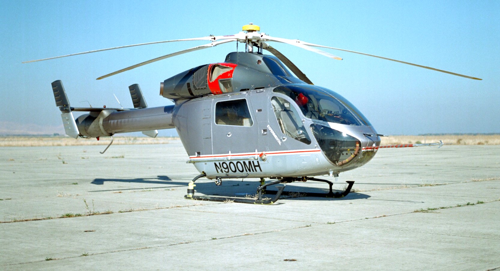
and was the site of Hughes 500D COBRA testing in September 1980.
Crows Landing was the site of McDonnell Douglas flight testing in 2/24/82 (according to Bruce Grolmier),
as well as YO-3A flight testing in 4/28/82.
According to Martin Maisel, “During the 1980s, the NASA Ames Research Center (located at Moffett Field)
conducted flight test operations at Crows Landing.
Moffett Field is located in the densely populated San Francisco Bay area which has a high level of commercial & general aviation traffic.
The primary advantages of flight testing at Crows Landing were that it was less than 60 air miles from Moffett Field,
it was located in an agricultural area with few population centers & there was minimal air traffic in the vicinity.
Ames established a flight research station at Crows that included Pulse-Code-Modulation telemetry
and analog receivers & recording equipment, a radar tracker & a Laser tracker.
In addition, telemetry received at Crows could be transmitted to engineers at Ames in real-time via a repeater transmitter on nearby Mount Diablo.”
Martin continued, “The site at Crows was suitable for flight test that had a higher than normal risk.
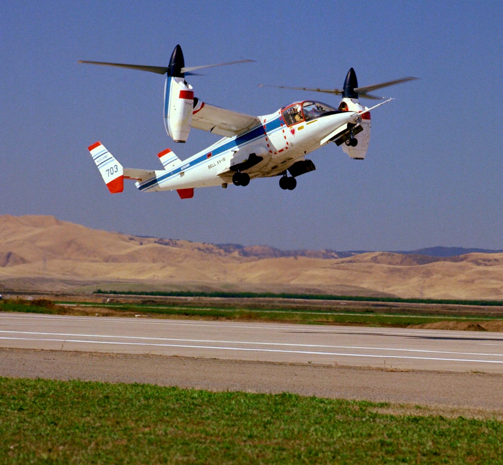
For example, the Army/NASA XV-15 Tilt Rotor Research Aircraft conducted high speed aeroelastic stability testing over the Central Valley,
using Crows Landing as a base & for data acquisition.
Additionally, the quiet remote site proved to be suitable for ground-measurements of aircraft acoustics.”
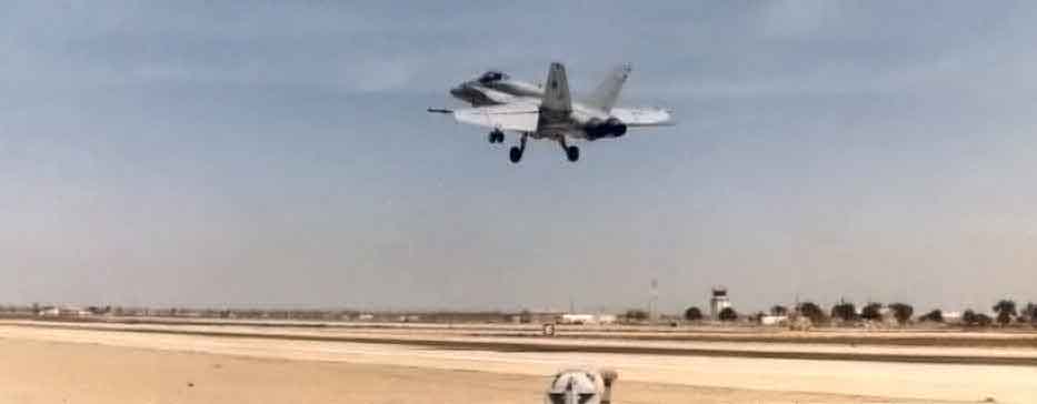
A 1983 photo by George Jones of an F/A-18 Hornet from Lemoore NAS making a practice carrier approach at Crows Landing NALF.
Crows Landing was also continued to be used by the Navy as an outlying training field.
According George Jones (who was in charge of the weather detachment at Crows Landing from 1983-1984),
the field had a fair amount of Navy traffic, even though no Navy aircraft were stationed there.
This consisted mostly of P-3s on training flights from NAS Moffett Field.
The ends of the runways were painted to resemble carrier decks & F/A-18s from NAS Lemoore
would practice carrier approaches at Crows Landing prior to going through Carrier Qualifications.
A portable set of carrier landing/approach lights would set up on either end of the main runway.
The Landing Signal Officers would fly up from Lemoore in an O-2.
During that time, Navy personnel at the base consisted of 20-30 active duty sailors.
Most were involved with maintaining the base & providing Crash & Rescue services.
A 1985 photo by John Voss of the Navy entrance sign to Crows Landing.
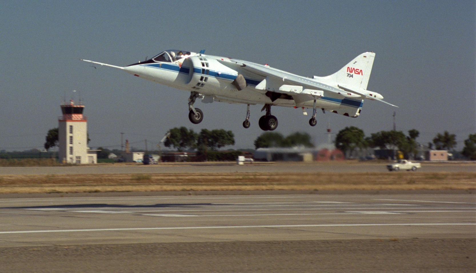
A 10/7/85 NASA photo of a AV-8A Harrier V/STOL take off at Crows Landing.
Eric Weber recalled, “From 1989-91 we would regularly use Naval Auxiliary Landing Field Crows Landing to shoot instrument approaches on local training flights.
My Air Force squadron was the 1400th MAS McClellan AFB. We flew the C-21 which is a Lear 35 equivalent.
Very quiet airfield, we would drop in for a few instrument approaches, then go to Stockton or Castle AFB, then back to KMCC.”
NASA intermittently used Crows Landing to support flight tests by aircraft based at Ames Research Center & other NASA facilities.
According to John Crozier, “The Navy & NASA co-habited there for many years.
The Navy closed down operation [at Crows Landing] in the early 1990s, as part of the NAS Moffett Field closure.
NAS Moffett was our parent command when I was there.”
NASA then became the operator of the field.
Raymond Meyer recalled, “NASA only had title to the airfield for a short period of time.
Expenses became a burden on their budget. It was decided to turn the airfield into a 'Federal Airfield'.
It allowed other federal, state and local agencies use the former Navy facility,
and it spread base expenses over a number of agencies.
That is why the sign at Crows Landing now says 'Moffett Federal Air Field, Crows Landing Flight Facility, NASA Ames Research Facility'.”
According to Martin Maisel, “In September 1991 a failure of a component on an experimental rotor
resulted in a successful emergency landing of the XV-15 at Crows Landing.
To my knowledge, that incident was the only emergency landing that occurred during the NASA flight test at Crows.”
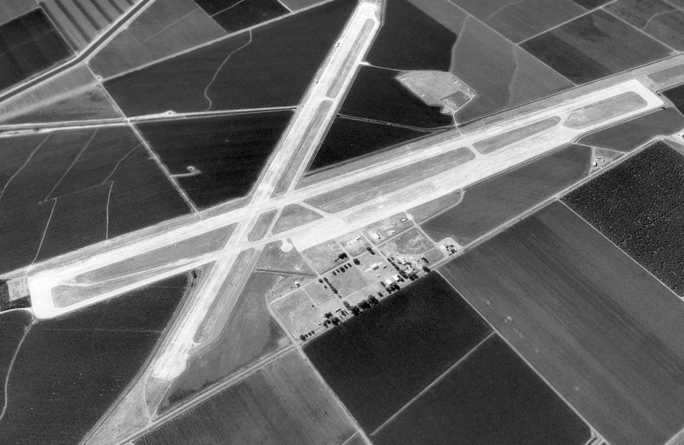
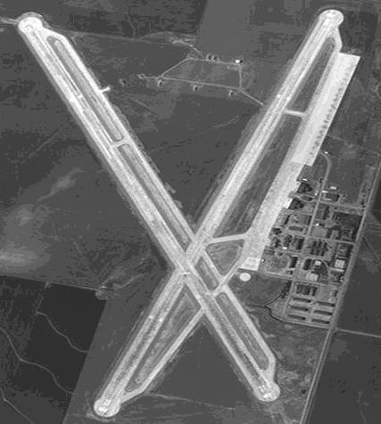
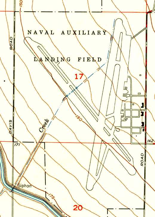
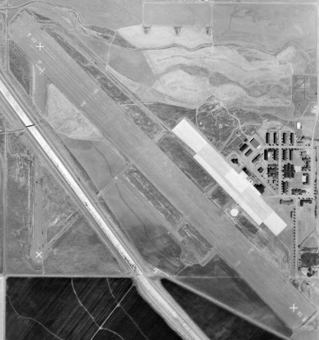
A 1998 USGS aerial view looking northwest at the Crows Landing Airfield.
Crows Landing was closed in 1999 by NASA.
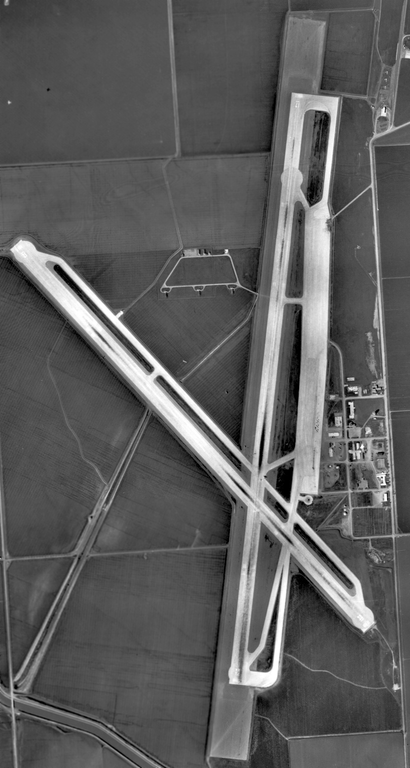
At the time of its closure, the airfield at Crows Landing consisted of 2 paved runways (the longest, 17/35, was 7,950').
Jack Daley reported in 2003 that Crows Landing is "Currently completing a massive EPA/Navy cleanup.
It is mostly now owned by the County Of Stanislaus.
It was transferred to the County 3 years ago (completed in 2000)
under the auspices of (now former) Congressman Gary Condit (of the recent missing DC intern fame)."
Jack continued, "The field is currently wide open with the nearby Sheriff Office substation conducting occasional patrols.
The tower & crash building still stand, as do the field Recreation Building & pool area.
NASA has some trailers with satellite antennae in occasional use on the NE side of the field.
No one is ever seen there from their offices at Ames.
The 2 concrete runways are deteriorating fast. Ground water clean-up is continuing.
The airfield is X'd off, but local trainers still shoot occasional touch & go's."
Jack continued, "A year ago an SFPD chopper crashed nearby in the low lying valley fog trying to make the field.
They had some sort of a maintenance problem while enroute from Visalia (where the aircraft was in for an annual!) back to SF.
Killed both officer/pilots."
Jack continued, "Apparently the County really does not have concrete plans for the field other than to complete the clean-up
and possibly attract some aviation-oriented businesses.
Talk of a park of some sort is just that - talk.
FBOs are not interested due to this economy, and it's remote agricultural location. Not even dusters.
The former Castle AFB in Atwater/Merced a few miles away is in a much more attractive urban setting."
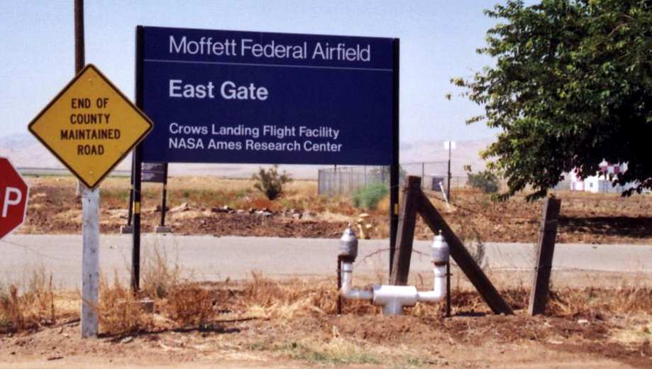
A 2003 photo by John Voss of the NASA entrance sign to Crows Landing,
which (confusingly) labeled it as "Moffett Federal Airfield, Crows Landing Flight Facility".
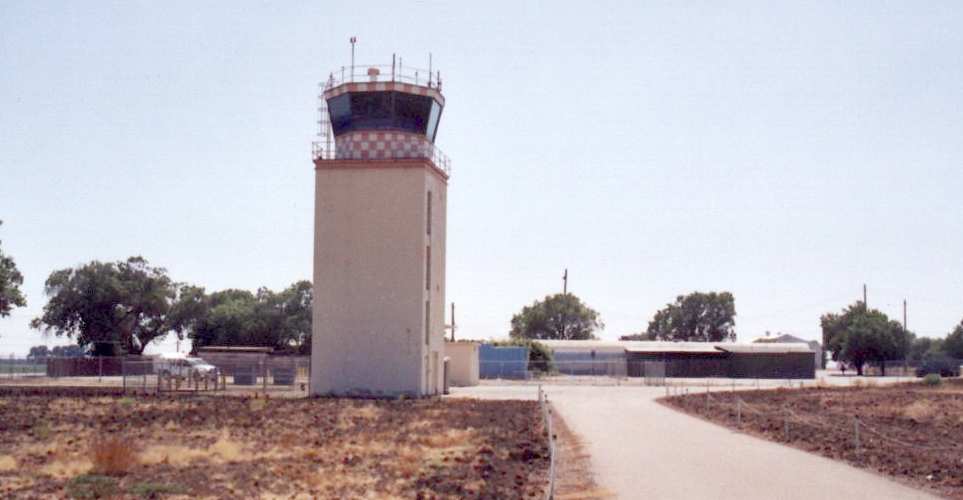
A 2003 photo by John Voss of the control tower at Crows Landing.
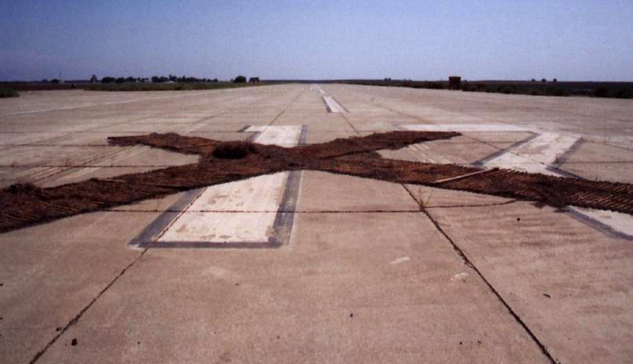
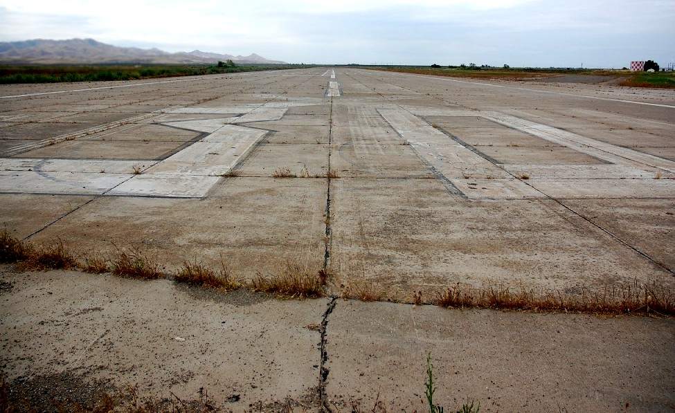
A 2003 photo by John Voss of Runway 12 at Crows Landing,
with the numbers covered by a wooden closed-runway "X" marker.
A February 2005 aerial photo by Jonathan Westerling looking west at Crows Landing.
Jonathan observed, “Crows Landing looks to be in good condition.
No planes were visible anywhere on the property. ”
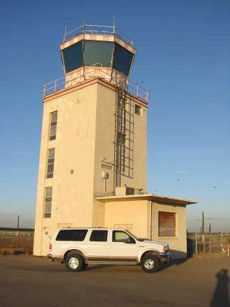
An October 2005 photo by Pen Parks of the abandoned Crows Landing control tower.
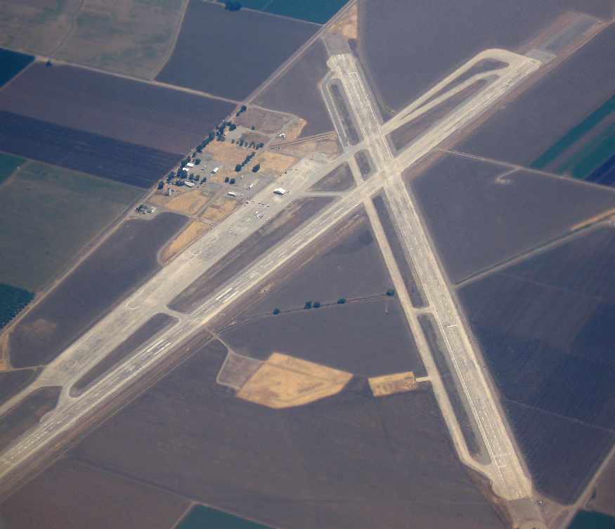
A December 2006 aerial view by Ian Carisi looking southeast at Crows Landing.
As of 2007, Stanislaus County was trying to promote the reuse of the airfield
as the Crows Landing Business Air Park.
Stanislaus County has taken title to over 1,350 acres of the 1,527 acre former military base,
and “the planning team has been moving efficiently toward our ultimate goal
of job creation, multi-modal distribution, and general aviation reuses for the west side of Stanislaus County.”
Chris Thompson reported in 2007, “I decided one day to drive out to the former NALF Crows Landing
and see what things were like out there after all these years of neglect.
Stanislaus County is in the process of converting this former Navy facility
into a business airpark supporting business & general aviation.
I am a Stanislaus County employee & have been in touch with the folks in the county department
involved in the development project of this facility.
I actually took the time to drive the runways & come to some sort of determination as to the shape of the runways.
In my opinion, they're still in remarkably good shape.
I expect some of this is due to the fact that the runways & tarmac were poured concrete rather than asphalt, which holds up better.”
Chris continued, “Here is what I found: Runway 30 is no longer X'd off.
It is certainly still in a usable condition short of some loose gravel at the threshold end of both ends of the runway.
Runway 12 still has the lumber & chain materials used to X it off atop the numbers,
but little of it remains as the lumber was burned & all of it piled up directly in the middle of the numbers.
Runway 17 no longer appears to be X'd off. At the threshold end of Runway 17 & for about 50-100',
there is some loose gravel strewn about this end of Runway 17.
There is also some agriculture related materials just off numbers end of Runway 17.
There is a lot of agriculture operations taking place on the grounds of the former NALF.
Runway 35 has a partial X (single line) atop the numbers.
It too has some agriculture-related materials just off the end of the runway.”
Chris continued, “I overflew NALF Crows Landing a couple of weeks ago
and realized I could not see any indication of the runways being closed,
other than the indication of the field being closed on the San Francisco sectional.
In my opinion, the runways at 7,000+ feet each, are still in good enough shape for use by the occasional training flight.
One item to note: The Stanislaus County Sheriff's department operates out there using the tarmac & runways
for driving training occasionally during the work week.
I'm not sure how'd they take to a landing aircraft during these operations.
Also, the runway markings are certainly still in good enough shape to see from the air & the ground,
although there is all the additional markings used by Navy aviators to simulate an aircraft carrier environment.”
Chris continued, “I also walked around some of the facilities. The former Navy Exchange building is definitely in serious decay.
Most of the roof has collapsed. The pool is filled in with dirt.”
![]()
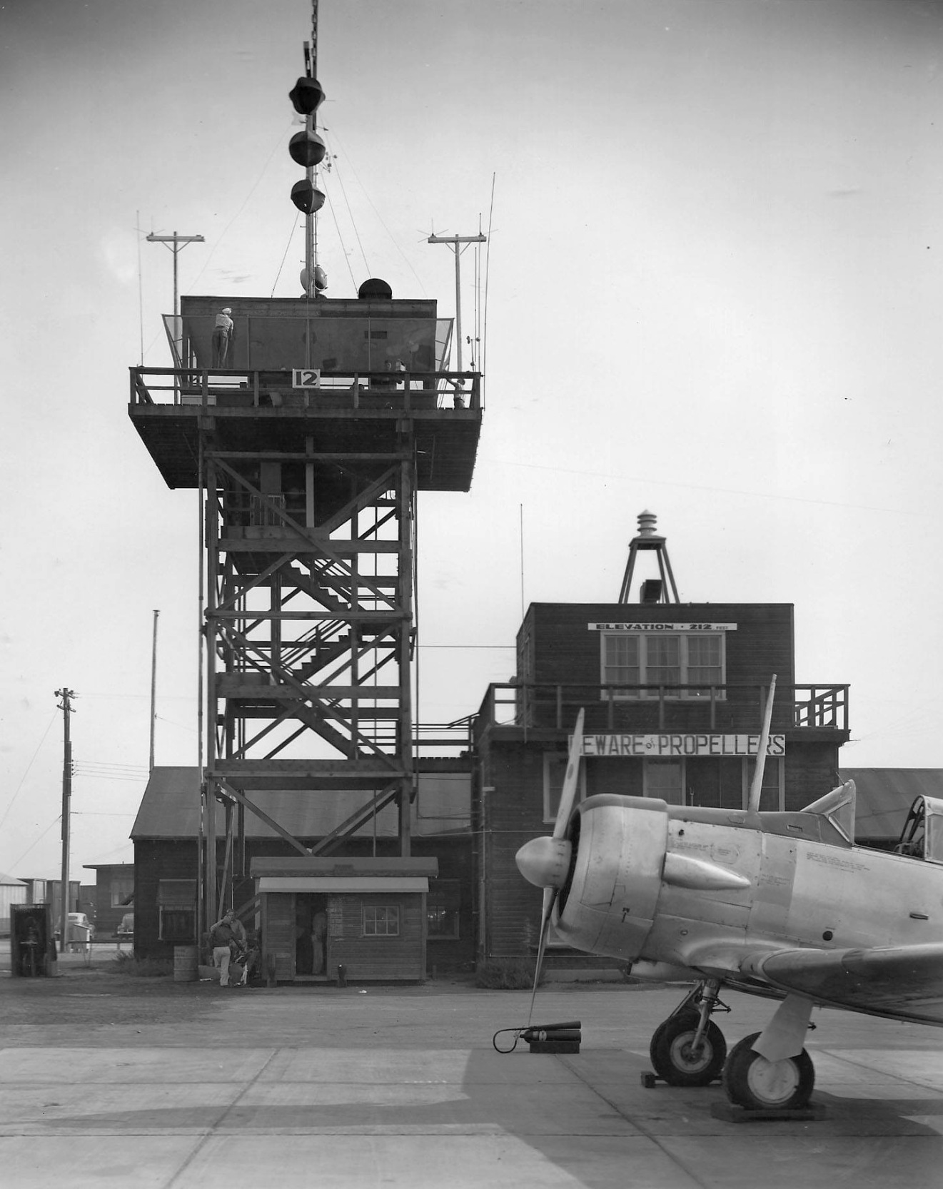
A 2007 photo by Chris Thompson of the former base fire station & beacon light tower.
Chris continued, “I expect the county will only restore the tower & the fire station.
I decided to take a little risk & enter the tower building. The door has since been pried open & all that holds it shut is a trash can.
There are postings on virtually all the buildings regarding asbestos.
Certainly, I was careful not to disturb any materials that might kick up dust containing asbestos.
I climbed the cement stairwell in the tower up 3 floors.
I peaked into the equipment room that still housed equipment racks & cabling where equipment once was installed & since removed.
All that remained was the racks & cable harnesses.
I did not attempt the climb up the vertical ladder into the tower operations area itself
as the mounting hardware securing the ladder did not appear secure enough to hold my weight.
This was disappointing as I was curious as to the condition of the operations area of the tower.
In any case, I did not want to remain too long in a building that possibly contained asbestos.”
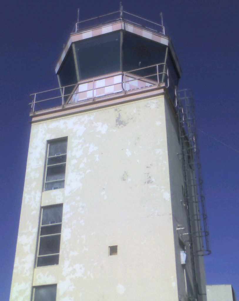
A 2007 photo by Chris Thompson of the abandoned Crows Landing control tower.
Mike Roe reported, “In 2007 I drove out to Crows for a look-see. Very spooky... and disappointing to see the old place in such disrepair.
I was nervous about being there as there were Keep Out signs all around. So, I didn’t hang around too awfully long.”
John Crozier reported in 2008, “Although not marked with X's, I do not believe the runways are yet certified for public use.
As of my most recent San Francisco sectional (expired 2008), the facility was still listed as 'NASA Crow's Landing (closed)'.”
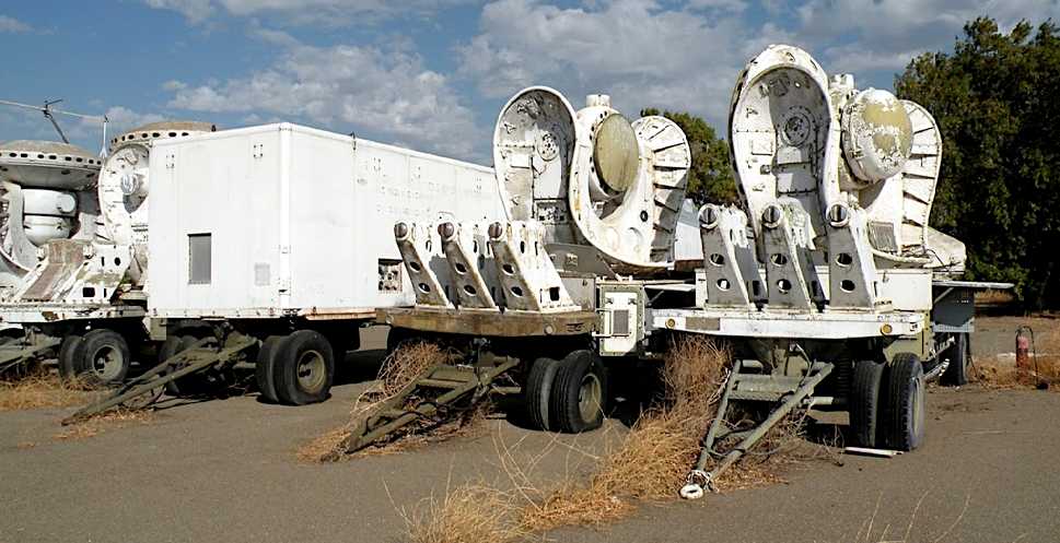
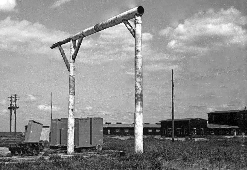
A 10/18/08 photo by Andria Corosati of tracking radars from a Nike Hercules missile system at Crows Landing.
What was their purpose at Crows Landing?
Andria Corosati reported in October 2008, “The buildings are, for the most part, is fairly good condition -
however, its very clear that there has been a lot of vandalism, especially with the control tower.
The most [2007] photo of the control tower shows the windows still intact.
Since then, it looks like a number of the windows were kicked out, and there is a fire extinguisher hanging out of one of them.
Additionally, there's a number of old NASA/US Army communications & radar tracking vehicles on site -
that look like they've been there for a while.
I was leery of getting too close, as it seems they have become home to a swarm of bees.
The Stanislaus County Sheriff uses the site.
They have a number of police cars parked in a fenced area, and a road course set up on one of the tarmacs.”
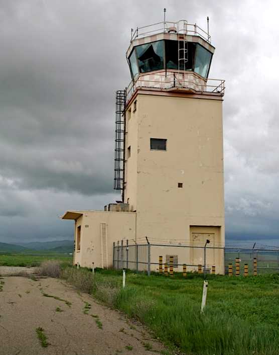
A 2/26/10 photo by Andria Corosati of the Crows Landing tower, showing the broken windows.
Andria reported, “The vandalism has gotten worse - the windows in the control tower have now been broken out from the inside.
I did not stay long this time to better inspect the facility as there were some rather sketchy people hanging around & I felt rather unwanted.
Most of the condition of the field aside from the control tower appears to be unchanged.”
A May 2010 photo by Mike Molsbergen looking northwest along Crows Landing's Runway 30.
Mike reported, “My wife & I made a drive by Crow's Landing yesterday.
It's a sad sight. The buildings are in bad shape & many are overgrown.
The tower is a mess with many broken windows. Some of the roads are barricaded with Stanislaus County signs.
There was some kind of training going on with EMS vehicles at the site.
Runway 30 can be accessed from the East boundary road. The old '30' is more visible than the 'X'.
On taking a close look at the 'X', it looks like it was painted over with a gray paint that more closely matched the concrete so it would be less visible,
but both gray & white paints are peeling & fading away.”
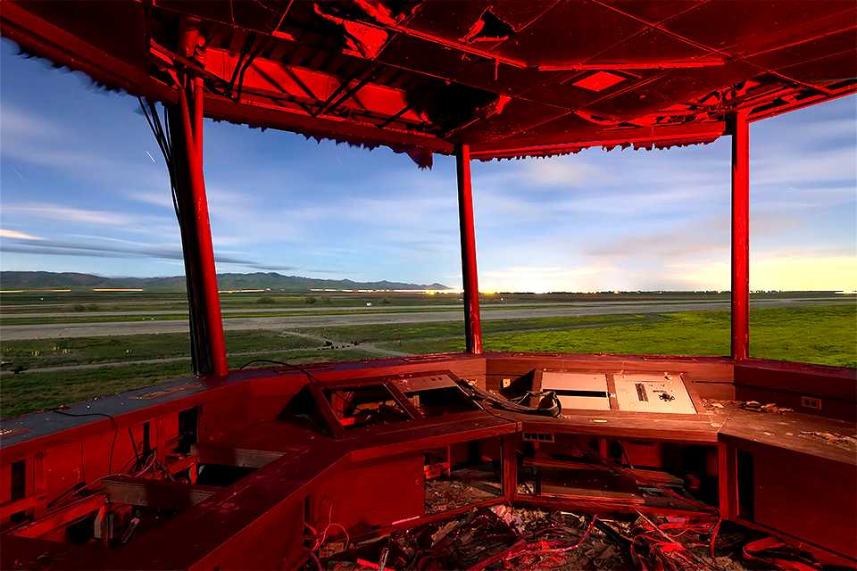
An amazing March 2013 photo by Troy Paiva of the interior of Crows Landing's control tower.
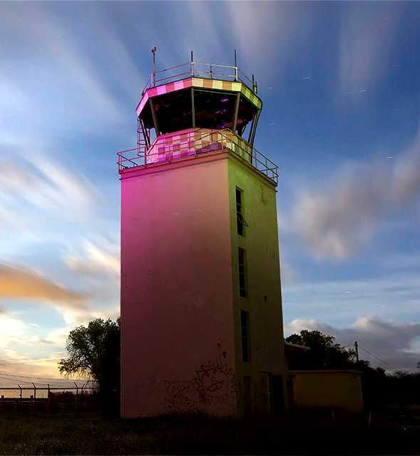
A March 2013 photo by Troy Paiva of Crows Landing's control tower.
Troy reported, “Asbestos clean up continues. Demolition of the major structures appears imminent.”
A March 2013 photo by Troy Paiva of Crows Landing's control tower.
Troy reported, “The local Sherriffs still use the taxi/runways for tactical driving practice.
Cool place in the middle of the night!”
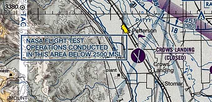
Even though Crows Landing was labeled as closed on the March 2013 Sectional Chart (courtesy of Dallam Oliver-Lee),
a note still indicated “NASA flight test operations conducted in this area below 2,500' MSL.”
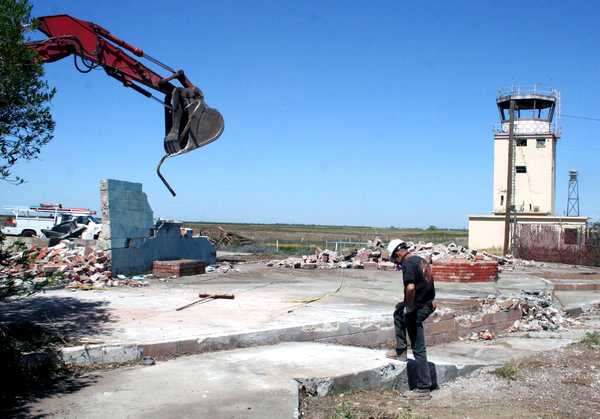
An April 2013 photo by Jonathan Partridge of the demolition of the Crows Landing Recreation building, with the Navy control tower in the background.
An article entitled “Demolition continues at former airbase” by Jonathan Partridge in the 5/18/13 Patterson Irrigator (courtesy of Ron Plante)
described how NASA has been forced to demolish most of the buildings at Crows Landing due to frequent vandalism.
Luckily the control tower will be left standing, at least for the time being, due to their historic value.
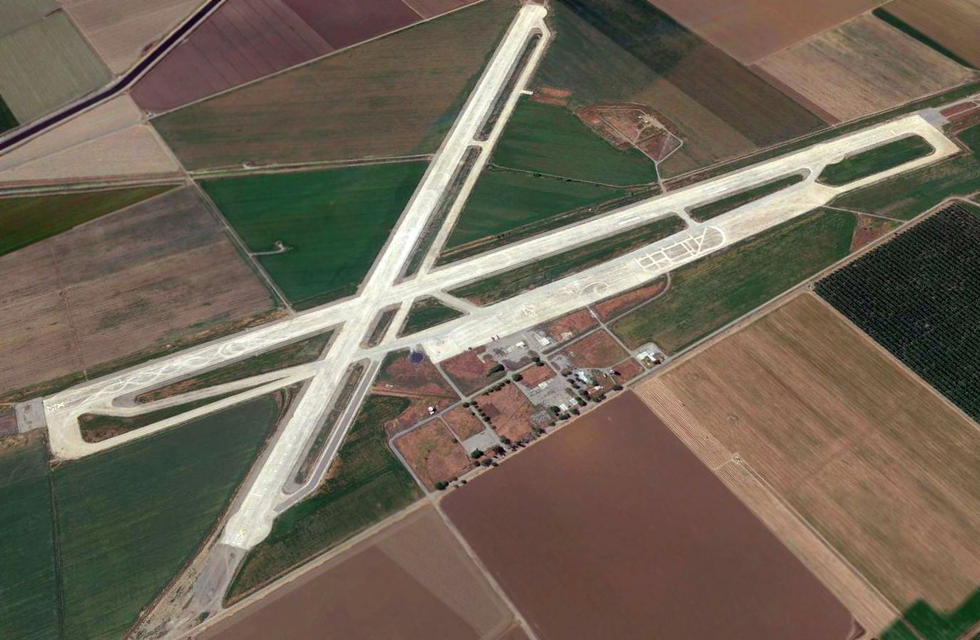
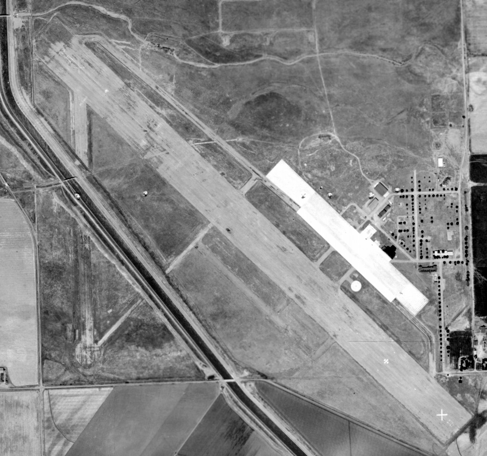
A 2015 aerial view looking northwest at Crows Landing showing the extensive aviation infrastructure which remains.
As of 2016, Crows Landing had a contradictory status, as it Fritz Glasser reported it was depicted on Sectional Charts as a private airfield,
yet it was not listed at all in FAA Airport/Facility Directory data.
Walter Ward reported in 2017, “To see the place now is very sad & deeply nostalgic.
I visit it quite often alone to think & remember & to feel & listen for the ghosts.”
____________________________________________________
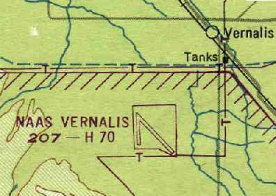
Vernalis Naval Auxiliary Air Station, Vernalis, CA
37.6, -121.316 (East of San Francisco, CA)
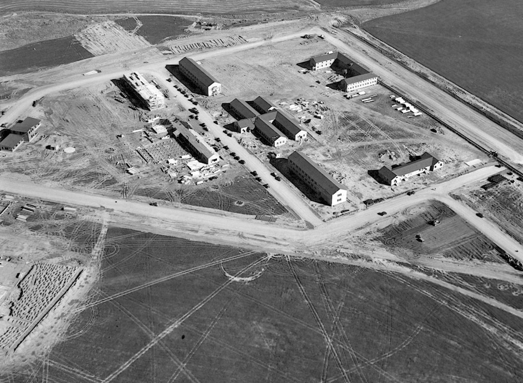
A circa 1942-43 aerial view looking north showing NAAF Vernalis under construction (courtesy of John Voss).
The Navy purchased 700 acres in 1942 to build a base to support 2 multi-engine patrol squadrons.
The earliest depiction which has been located of Naval Auxiliary Air Field Vernalis was a circa 1942-43 aerial view showing it under construction (courtesy of John Voss).
Barracks & administration buildings were being constructed, but the ramps & hangars had not yet been built.
Naval Auxiliary Air Field Vernalis was commissioned in 1943.
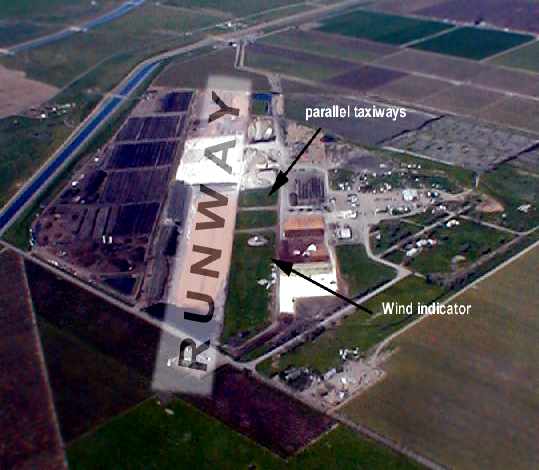
It would serve as an auxiliary of Alameda NAS, and initially had a single 4,000' x 500' tarmac runway.
Gordon Bastien recalled, “Vernalis Auxiliary Naval Air Station...I was stationed there in 1943 for several months before shipping out to the Pacific.
It was a PV-1 & PV-2 base. We built the bombing range to the West of it
and trained the bomber crews in low-altitude bombing & aerial gunnery during the time I was there.
I made my first rate at that base... Aviation Ordnanceman 3rd class.
I also met my 'to be' wife in Modesto as that was our liberty town & we traveled in 'Cattle Cars' to get to town.
That was a big trailer with bench seats & window cut outs being pulled by a truck tractor.
It was always windy & cold and noisy riding in that damn thing.
During the operation it had 2 nose hangars & had PV squadrons VP-139 through about VP-148.”
Later in 1943 Vernalis' runway was extended to 7,000', and the field was redesignated as a Naval Auxiliary Air Station.
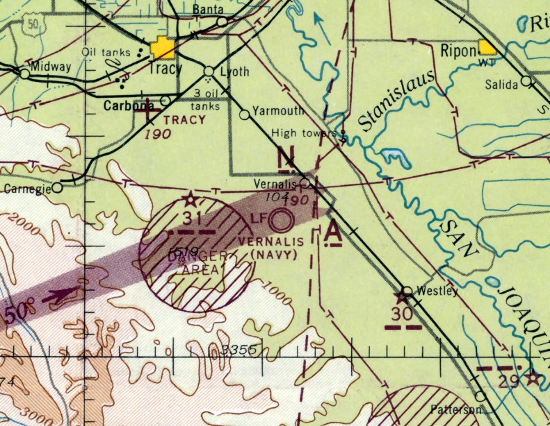
The earliest aeronautical chart depiction which has been located of the Vernalis airfield was on the August 1943 San Francisco Sectional Chart.
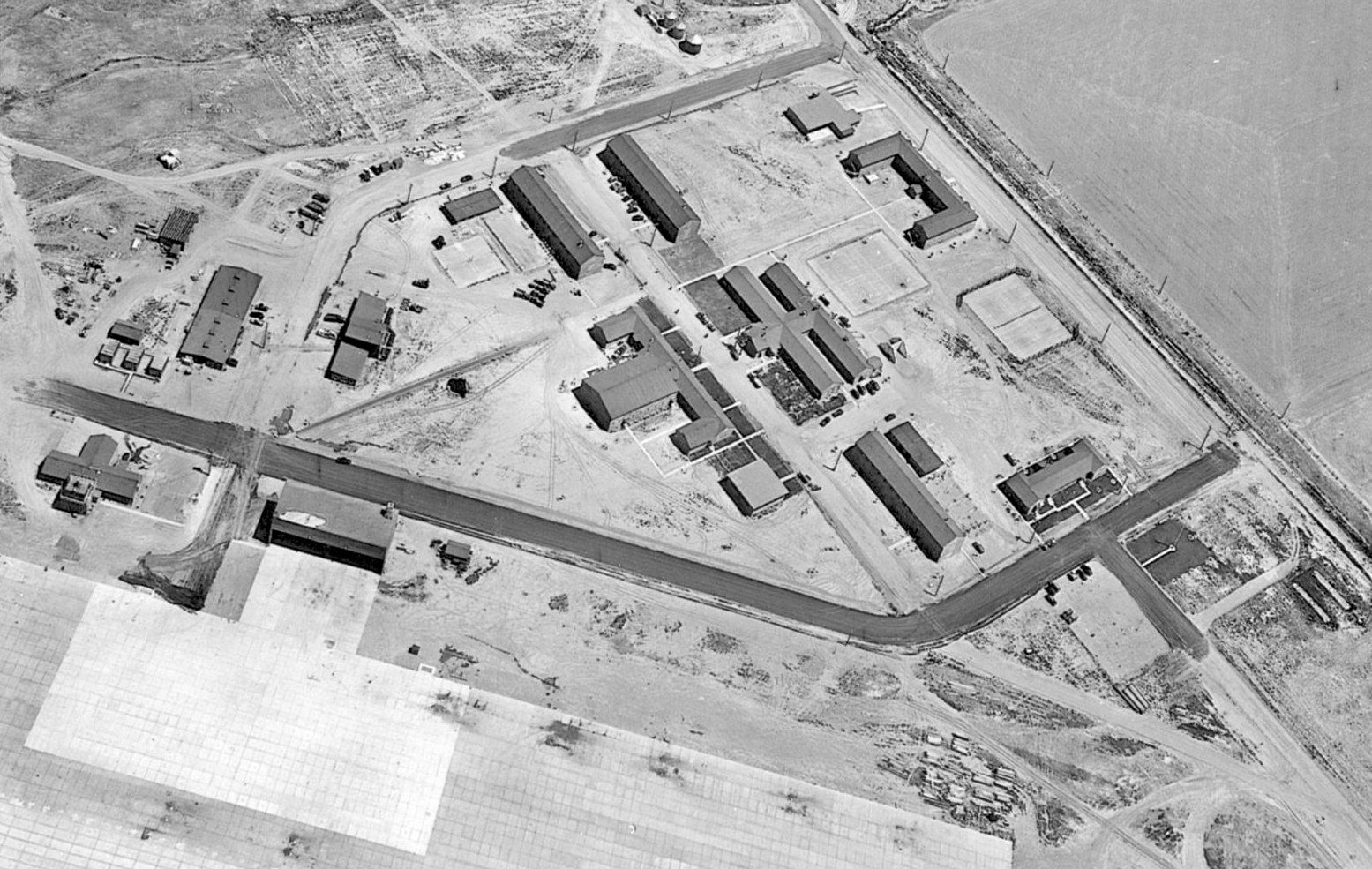
A circa 1943-44 aerial view looking north at the ramp, hangar, and other buildings at Vernalis (courtesy of John Voss).
A circa 1943-45 photo of a North American SNJ Texan in front of the Vernalis NAAS control tower (courtesy of John Voss).
In 1944, Vernalis' patrol aircraft were shifted to Crows Landing, and Vernalis became host to carrier squadrons.
A 160 acre dive bombing range was added to support the carrier squadrons.
Due to the limited crosswind capability of the smaller carrier aircraft, a 4,000' crosswind runway was added.
Runway lighting was installed, as well as carrier catapult & arresting gear.
A circa 1943-45 photo at NAAS Vernalis of a Grumman F6F Hellcat with extended arresting hook making an approach over a replica aircraft carrier wooden deck runway (courtesy of John Voss), with the flightline, hangars, and aircraft in the background.
A circa 1943-45 aerial view looking east at a crowded NAAS Vernalis ramp, showing dozens of Navy aircraft, the control tower, hangars, and other buildings (courtesy of John Voss).
According to Michael Guerin (whose father was at Vernalis & Crows Landing during WW2), at one point early steam catapults were tested at Vernalis,
and there were some bad accidents/explosions, in which there were injuries & deaths.
At a strafing range on the Diablo Mountains to the west, a silhouette of a submarine was painted on the rocks to be used as a target.
German POWs were housed at Vernalis late in the war, and assisted in construction projects.
"Vernalis (Navy)" was still depicted as an active military airfield on the March 1945 San Francisco Sectional Chart (courtesy of Chris Kennedy).
The 1945 AAF Airfield Directory (courtesy of Scott Murdock) described Vernalis NAAS
as a 710 acre square-shaped property containing 2 asphalt runways: 7,000' northwest/southeast & 4,000' north/south.
The field was said to have a single 125' x 60' wood hangar. Vernalis was described as being owned by the U.S. Government, and operated by the Navy.
A circa 1940s aerial view looking south at Vernalis NAAS (courtesy of John Voss), showing the 2nd runway which had been added.
This photo possibly was taken after the end of WW2, as the airfield was devoid of aircraft.
After WW2, Vernalis initially was chosen to remain open; however, Crows Landing received the nod due to its concrete runways.
On 10/15/45, Vernalis was placed on caretaker status & finally abandoned 3 months later.
"NAAS Vernalis" was depicted on the 1949 San Francisco Local Aeronautical Chart (courtesy of Chris Kennedy)
as having 2 paved runways, with the longest being 7,000'.
The 1952 USGS topo map depicted the Vernalis “Naval Auxiliary Air Station” as having a paved runway, parallel taxiway, ramp, and a large number of buildings.
At some point between 1949-52 the Delta Mendora Canal had been built over the western portion of the former airfield, running through the middle of the crosswind runway.
A 1952 aerial view of Vernalis (from the Alexandria Digital Library, courtesy of Chris Kennedy)
showed the entire length of the primary runway appeared to remain intact,
but the crosswind runway & its connecting taxiway had been bisected by the Delta Mendora Canal.
The street grid, some buildings, the ramp area & portions of taxiways still existed.
A 7/15/53 USGS aerial view of Vernalis showed the entire length of the primary runway appeared to remain intact,
but the crosswind runway & its connecting taxiway had been bisected by the Delta Mendora Canal.
The street grid, some buildings, the ramp area & portions of taxiways still existed.
It was still labeled as "Vernalis (Navy)" on the 1955 & 1956 San Francisco Sectional Charts (according to Chris Kennedy),
but the Aerodromes table on the chart included the remarks, "Closed. Emergency only."
Vernalis was used by the Air Force in the 1950s to launch 300' diameter balloons that performed "experiments" in the stratosphere.
According to Scott Murdock, it was listed as the "Vernalis Geophysics Annex".
The balloon launches Vernalis were operated by the Air Force Cambridge Research Laboratory.
The first use was related to a country-wide project started by the Air Force called "Moby Dick" & intended to study high altitude wind patterns,
with the first balloon launched from Vernalis on 1/8/53.
For this project, Vernalis (among other bases) was chosen to launch stratospheric balloons which traveled throughout the U.S. & landed in sites as far as Mexico, Canada, and Europe.
After this project was finished several other balloon mission took place there during the decade including some flight test of balloon surveillance equipment
and a series of launches to test launch techniques & systems in the framework of a project to detonate a nuclear device under a balloon
(which eventually took place at the Eniwetok Proving Grounds in 1958).
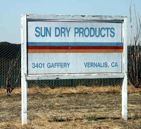
Richard Hector recalled, "I grew up on Gaffery Road in Vernalis; the road that led to the base.
We moved to the area in 1960; my father was a farmer. The Vernalis base launched balloons… I think that this activity went into the 1960s.
My father told me today that one balloon launched there went as far as Spain.”
The last balloon launched from Vernalis was in 6/2/61, landing eventually in the Alaskan Aleutian Islands.
A 6/1/63 aerial view of Vernalis (from the UCSB Library) showed the entire length of the primary runway appeared to remain intact,
but the crosswind runway & its connecting taxiway had been bisected by the Delta Mendora Canal.
The street grid, some buildings, the ramp, a hangar, and portions of taxiways still existed.
Richard Hector recalled, "In the late 1960s, there was an airplane painting business in one of the hangars (both small & large planes), but that didn't last too long."
The Vernalis airfield was no longer depicted at all on the 1965 San Francisco Sectional Chart (courtesy of Chris Kennedy).
However, it was still depicted as "Auxiliary #2" on the 1969 USGS topo map.
The last photo which has been located of the Vernalis hangar was a 1969 photo by Michael Guerin.
Micheal recalled, “It was abandoned & not yet purchased by the current [2014] tenant - who knocked down most of the buildings.”
A 1969 close-up by Michael Guerin of the Vernalis hangar.
A 1969 photo by Michael Guerin of an unknown pole structure adjacent to the Vernalis hangar.
A 1969 photo by Michael Guerin of what appears to be inexplicably a ship screw in a junkpile on the abandoned Vernalis ramp.
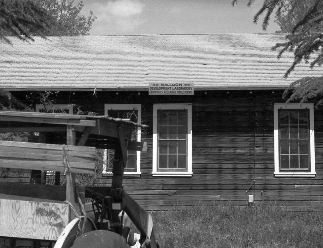
A 1969 photo of a building at Vernalis marked “Balloon Development Laboratory Geophysics Research Directorate”.
Richard Hector recalled, "In the early 1970's the runway became the site of a drag strip & some real excitement.
It started informally on weekends at first, but at some point there was a formal business & a real track established
that, while never attracting the big NHRA type dragsters, was nevertheless quite a draw in the valley.
Every Sunday, Gaffery Road saw hundreds of hot rods & trucks towing dragsters towards the air base.
But by 1980 even this shut down & the agriculture-based businesses took over.
They were spreading hundreds of truck loads of cannery by-products on the strip & letting nature do its thing;
the smell & the flies were unbearable if you were within a couple of miles of the place."
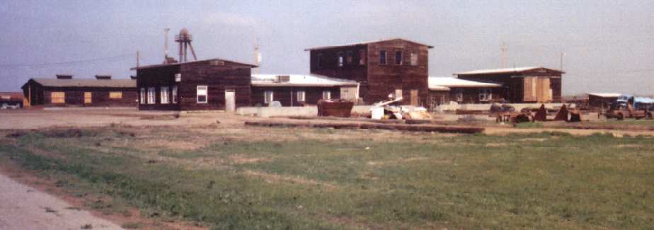
A 1985 photo by John Voss of WW2-era buildings which still remained standing (until they were later torn down) at Vernalis.
The Vernalis airfield was simply labeled "Landing Strips" on the 1989 USGS topo map.
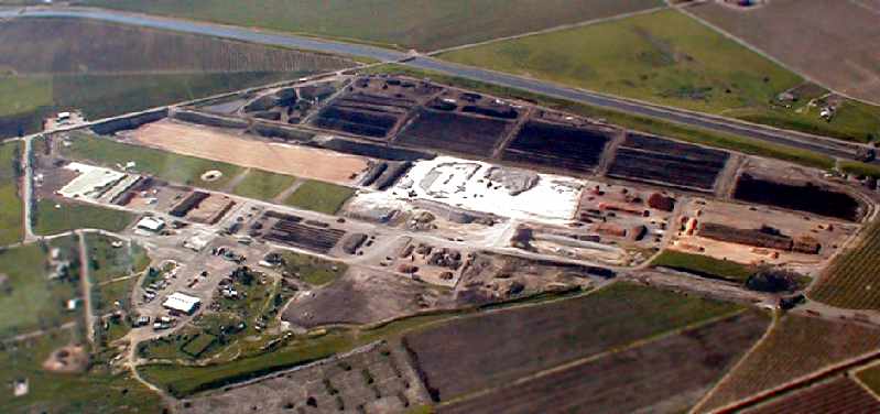
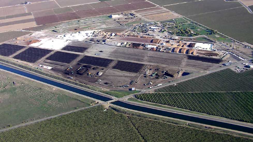
A 1993 USGS aerial photo showed the Vernalis property to be reused for various agricultural purposes.
The street grid, some buildings, the ramp area & portions of taxiways still existed.
The outline of a portion of the primary runway was still visible, as well as the outline of the crosswind runway, extending south from the canal.
Vernalis was still depicted as an abandoned airfield on 2002 aeronautical charts.
Jack Daley reported in 2003 that "There is a large gravel washer & loading operation on the northern area of the former base,
and a wood recycling operation located on the former ramp area.
The old POW camp - which was both on the base itself & out along Hwy 33 near the village -
has finally had the last of it's guard towers torn down.
The asphalt runways - what's left of them - occasionally have a trainer shoot touch & go's.
But since NASA closed nearby Crows Landing those concrete runways are more attractive. Such as they are."
A 2003 photo by Tim Tyler of a wooden flagpole which is apparently the sole structure which remains
from the WW2-era Navy usage of the Vernalis airfield.
A 2003 photo by Tim Tyler of a small concrete building, which may date from the 1950s USAF usage of Vernalis.
A 2003 photo by Tim Tyler of the runways of the former NAAS Vernalis, now used to store piles of dirt.
A 2003 photo by Tim Tyler of the runways of the former NAAS Vernalis, now used to store piles of dirt.
A 2003 photo by Tim Tyler of the sign at the intersection of West Gaffery Road & the former main road to the base.
The Vernalis site was also visited by Tim Tyler & John 'Boss' Voss in 2003.
Tim's report: "The former NAAS is now approximately 5 different separate businesses sharing the former airfield -
scrap metal, scrap wood processing, and fertilizer manufacturing businesses,
all with large piles of their material along the old runway & ramp areas.
Numerous farm & construction heavy machinery seemed to be stored on the grounds as well,
and there were numerous 18-wheelers driving all over the place, loading & unloading material.
There are several concrete foundations probably remaining from the WW2-era,
one or 2 small concrete buildings (which probably dated back to the USAF use of the site in the 1950s),
and runway/ramp area remaining, but none of the old barracks, admin buildings, etc.
There are numerous newer (but still old) buildings on site.
The flagpole is intact along the access road, with nothing else around it.
We didn't see any structures that looked to be of WW2 vintage, however there were 2 concrete buildings.
Other than numerous concrete foundations & the runway/ramp area,
the sole (as far as we could see) remaining structure from the WW2 NAAS days
was the wooden flag pole along the entrance road to the site.
There was nothing around it, nor was a flag flying."
"We had spoken with a man on the site who was hosing off a bulldozer
and his understanding was that the businesses had been located on the site for approximately 10 years.
He knew it had been some sort of old airfield, but wasn't aware at all of the history.
He'd never observed any special remains or other items of historical significance in the couple of years he'd worked there.
We asked him where the office was, so we could explain ourselves & formally ask for permission to explore the grounds.
He pointed to a mobile home located in the center of the site,
near some other old (but not military related) buildings, and John & I did plan on stopping there.
As it turned out, a few minutes later, a Silver Suburban started following us,
and when we stopped & explained our quest, we were told to leave,
the reason being that sometime in the past, other people had been poking around the site,
collided with one of the numerous 18-wheeler trucks, and then the vehicle's occupants sued!"
Tim commented about how another reader of the web site
purported that small planes still occasionally shoot touch & goes there.
"Based on what I saw on Wednesday, there's no way any non-suicidal pilots would do that."
Jason Winters reported in 2004, "My good friend & business partner Conor Davis & I
have worked for Conor's dad who owns the property for a couple years
and then we went into business for ourselves in which we still operate out of the old base.
Conor's dad Jim has owned the property since the early 1980's
and has done mostly drying on the strip & storage of landscaping materials,
but now he's downsized & mostly leases the property out to Grover Landscaping & DPS Inc. (our company).
Conor & I have been there for the last seven years
and have always dreamed about cleaning things up & restoring portions of the old runway for our personal use
and living out there on the base & kind of turning into our personal airpark.
I think that dream will be coming true soon since we've just acquired our pilots license & purchased a plane."
A February 2005 aerial photo by Jonathan Westerling looking southwest at the site of the former NAAS Vernalis.
A February 2005 aerial photo by Jonathan Westerling looking northwest at the site of the former NAAS Vernalis, annotated to show the location of the former airfield.
Former Vernalis veteran Gordon Bastien recalled visiting the site of the base several years before 2006,
“I could stand on the end of the runway & still hear those engines revving for take off.”
An 11/15/09 aerial view looking north at the remains of Vernalis NAAS, taken by John Hollis from his powered parachute.
The site of Vernalis NAAS is located northeast of the intersection of Gaffery Road & Koster Road.
____________________________________________________
____________________________________________________
This site covers airfields in all 50 states.