Abandoned & Little-Known Airfields:
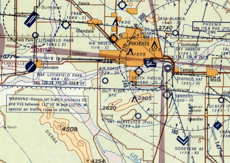
Arizona: Southwest Phoenix area
© 2002, © 2022 by Paul Freeman. Revised 5/3/22.
____________________________________________________
Please consider a financial contribution to support the continued growth & operation of this site.
Air-Topia Airport (revised 6/20/19) - Goodyear Aux AAF #6 / Luke AF Aux #6 (revised 9/21/19) - International Harvester Proving Ground Airfield (added 10/25/20)
Luke Auxiliary Army Airfield #7 / Hassayampa Field (revised 5/3/22) - Litchfield Park Airport (revised 5/3/22) - South Phoenix Airport (revised 2/13/19)
____________________________________________________
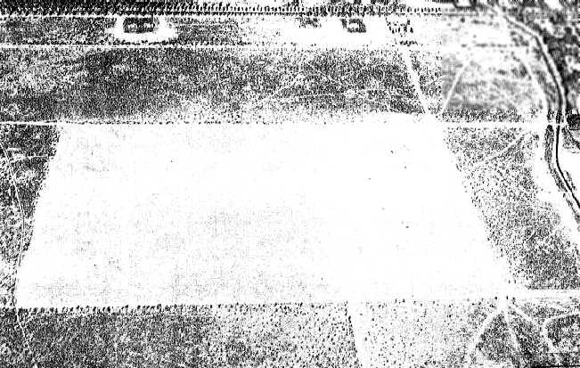
International Harvester Proving Ground Airfield, Phoenix, AZ
33.3, -112.054 (Southwest of Phoenix Sky Harbor Airport, AZ)
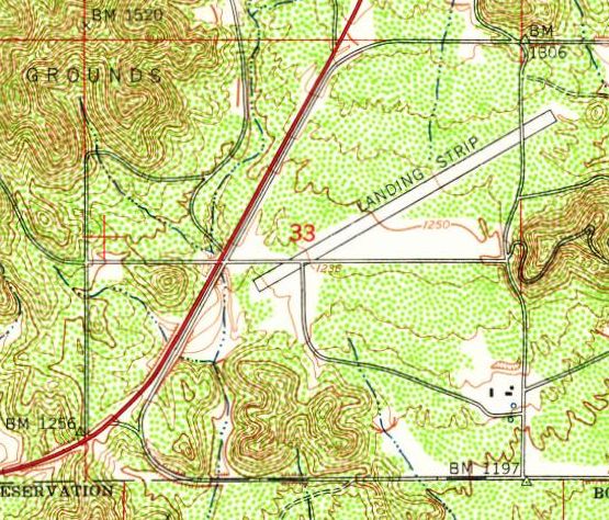
International Harvester Proving Ground Airfield, as depicted on the 1952 USGS topo map.
Photo of the airfield while in use has not been located.
This private airfield was within the expansive property of the International Harvester Proving Ground to the south of Phoenix.
The date of establishment of the International Harvester Proving Ground Airfield has not been determined.
No airfield at this location was yet depicted on the 1946 USGS topo map.
The earliest depiction which has been located of the International Harvester Proving Ground Airfield was on the 1952 USGS topo map.
It depicted a single 4,000' northeast/southwest runway, labeled generically as “Landing Strip”.
There were no buildings or other improvements depicted at the airfield.
According to kjzz.org, International Harvester constructed their airfield to allow their executives from the Midwest & potential clients to fly into their Proving Ground.
No airfield at this location was yet depicted on the March 1953 Phoenix Sectional Chart.
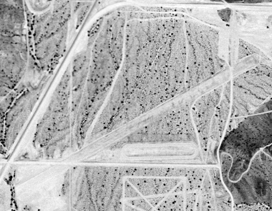
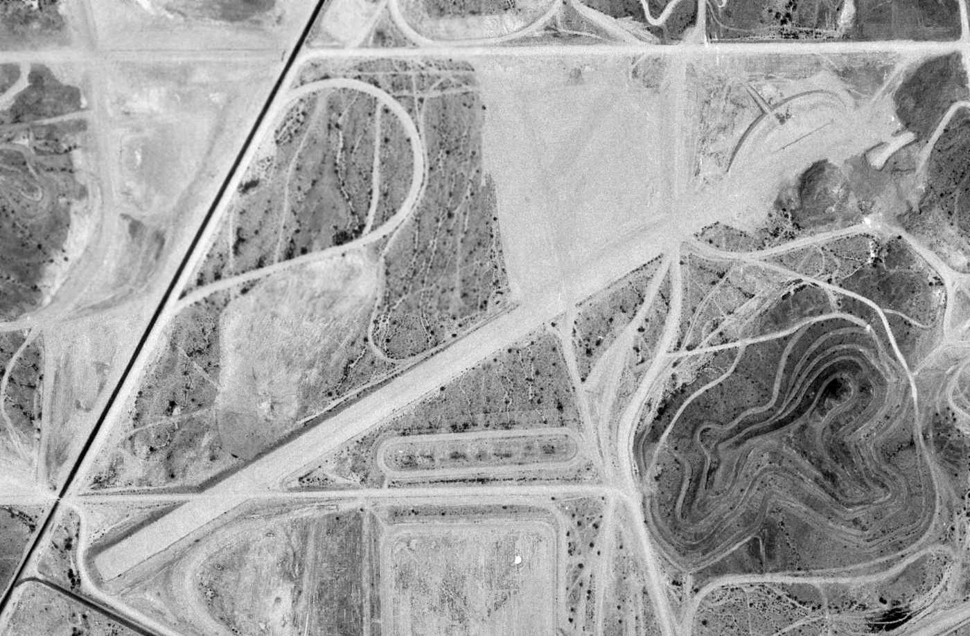
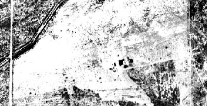
The earliest photo which has been located of the International Harvester Proving Ground Airfield was a 3/31/53 aerial view.
It depicted a single northeast/southwest unpaved runway, surrounded by the tracks of the Proving Ground.
There were no buildings or other improvements depicted at the airfield, nor any aircraft.
The earliest aeronautical chart depiction which has been located of the International Harvester Proving Ground Airfield was on the September 1953 Phoenix Sectional Chart.
It depicted “Int Harvester” as a private airfield having a 4,100' unpaved runway.
The last aeronautical chart depiction which has been located of the International Harvester Proving Ground Airfield was on the 1962 Phoenix Sectional Chart.
It depicted “Int Harvester” as a private airfield, with the runway length having been extended to 5,400'.
The International Harvester Proving Ground Airfield was evidently closed (for reasons unknown) at some point between 1962-65,
as it was no longer depicted on the January 1965 Phoenix Sectional Chart.
An 8/9/73 USGS aerial view depicted the International Harvester Proving Ground Airfield as having a single northeast/southwest unpaved runway, surrounded by the tracks of the Proving Ground.
There were no buildings or other improvements depicted at the airfield, nor any aircraft.
The 1975 USGS topo map continued to depict a single 4,000' northeast/southwest runway, labeled generically as “Landing Strip”.
According to kjzz.org, International Harvester sold their Proving Ground in the early 1980s.
A 1986 aerial view continued to depict the International Harvester Proving Ground Airfield in an unchanged fashion.
A 1987 aerial view showed the site of the International Harvester Proving Ground Airfield had been leveled, erasing any trace of the former airfield.
A 1988 aerial view showed streets for a new golf course community had been started to be built on the site of the International Harvester Proving Ground Airfield.
According to kjzz.org, the Foothills Golf Clubhouse was eventually built on the afield site.
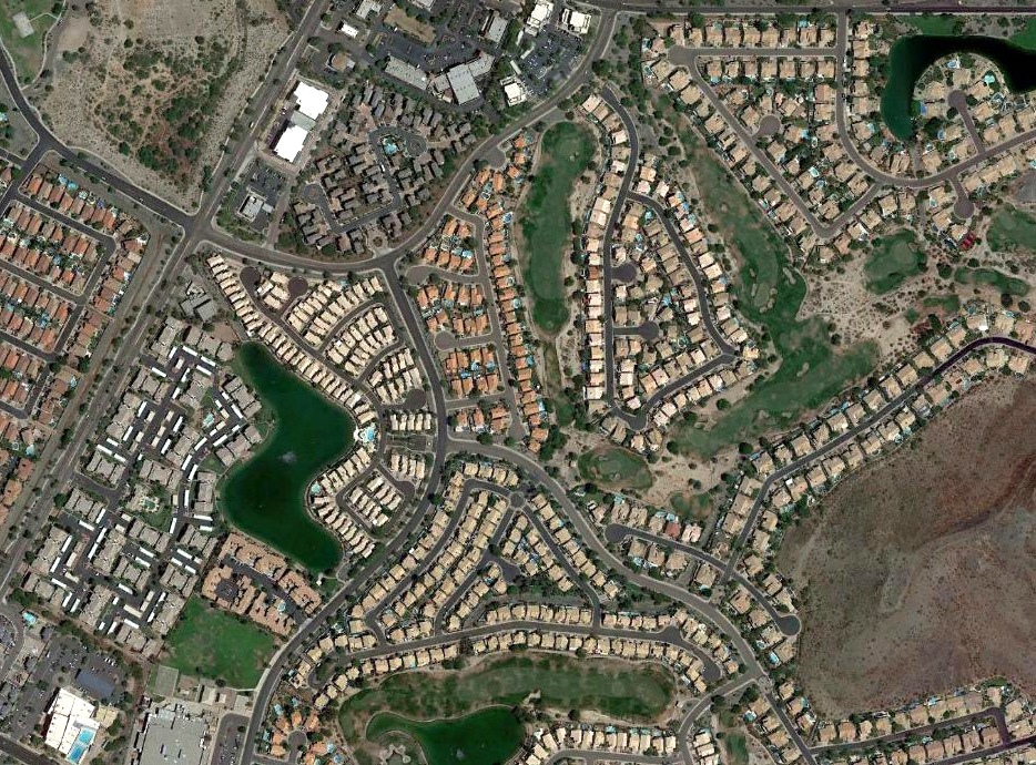
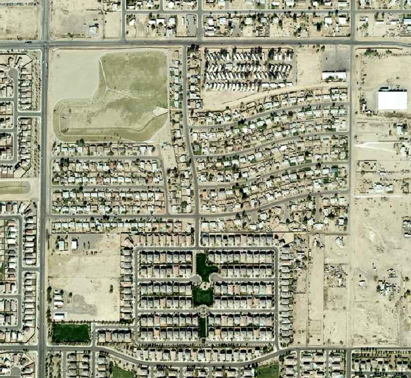
An 2019 aerial view shows no trace of the International Harvester Proving Ground Airfield, with the property covered by dense housing.
Thanks to Kevin Walsh for pointing out this airfield.
____________________________________________________
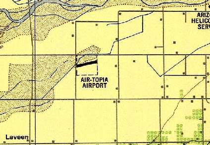
Air-Topia Airport, Phoenix, AZ
33.4, -112.16 (Southwest of Phoenix Sky Harbor Airport, AZ)
Air-Topia Airport, as depicted on the March 1946 Phoenix Sectional Chart.
According to Ron Chavez's book “The Valley's Airports of the Past”,
“Air Topia Airport was constructed sometime around 1943 as an auxiliary field for one of the military bases that were operating during WWII.
This little dirt strip was oriented in a northeast/southwest direction, 2,400' in length.”
However, Air-Topia Airport was not yet depicted on the September 1945 Phoenix Sectional Chart.
According to Ron Chavez's book “The Valley's Airports of the Past”,
“After the war, this airfield served as a crop duster loading field for the local crop dusting companies that were operating in the west valley.”
The earliest depiction of Air-Topia Airport which has been located was the March 1946 Phoenix Sectional Chart.
It depicted Air-Topia as an auxiliary airfield.
The 1948 USAF Urban Area Chart depicted Air-Topia Airport as having a single northeast/southwest runway.
The earliest photo which has been located of the Air-Topia Airport was a 1949 aerial view (from the Maricopa County Flood Control District).
It depicted the field as having a single unpaved northeast/southwest runway, with a few small buildings on the south side of the field.
The March 1949 Phoenix Sectional chart (courtesy of Chris Kennedy) described Air-Topia Airport as having a 2,400' unpaved runway.
According to Ron Chavez's book “The Valley's Airports of the Past”,
“In 1951 a company began their operation as an aircraft maintenance & repair company at Air Topia Airport,
which included fueling aircraft & conducting small engine repairs.
Air Topia also provided hangar & tie down space for private aircraft owners.”
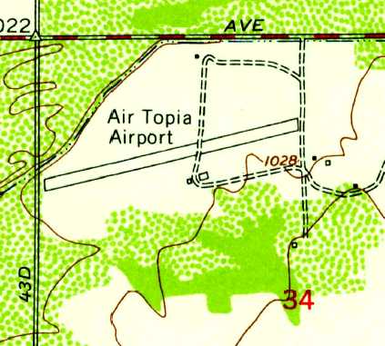
The 1952 USGS topo map depicted Air Topia Airport as having a single unpaved northeast/southwest runway,
with 2 small buildings on the south side of the field.
The Aerodromes table on the 1956 Phoenix Sectional chart (courtesy of John Voss) described Air-Topia Airport as having a single 2,400' bare runway.
The last aeronautical chart depiction which has been located of the Air-Topia Airport
was on the March 1958 Phoenix Sectional Chart (courtesy of Chris Kennedy).
It depicted it as having a 2,400' unpaved runway.
A 1958 aerial view depicted a single small aircraft on the ramp near Air Topia's hangar.
Air-Topia Airport was evidently closed at some point in 1958, as it was no longer depicted on the September 1958 Phoenix Sectional Chart.
A 2/19/59 aerial view (from the Maricopa County Flood Control District) depicted Air-Topia as having a single unpaved northeast/southwest runway,
with a few small buildings on the south side of the field.
But there were no aircraft visible on the field.
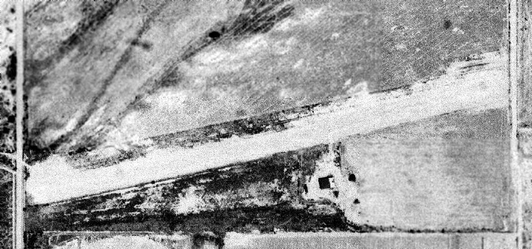
The last photo which has been located of the Air-Topia Airport was an 8/1/61 USGS aerial view.
It depicted the field as having a single unpaved northeast/southwest runway, with a few small buildings on the south side of the field.
According to Ron Chavez's book “The Valley's Airports of the Past”, “In 1961 the Air Topia Airport property was sold to a residential home developer.
The Air Topia Airport would cease operations in late 1961, in order to make room for the new home development that was being constructed.”
Air-Topia Airport was not listed among active airfields in the 1962 AOPA Airport Directory.
According to Ron Chavez's book “The Valley's Airports of the Past”, “The small hangar & the eastern portion of the runway were plowed under in 1963,
and by 1964 the east half of the airport property had been redeveloped into a new home subdivision.”
The 1967 USGS topo map & a 1969 aerial view showed that housing had been built over the eastern half of the site,
while the western half of the runway still remained intact.
According to Ron Chavez's book “The Valley's Airports of the Past”, “By 1970 all traces of the airfield had finally disappeared.”
The 1997 USGS aerial photo showed that the northwest corner of the Air-Topia Airport site remained an open field,
while housing had been built over the rest of the property.
No trace of the former airfield appeared to remain.
An 11/5/07 aerial view (from the Maricopa County Flood Control District) showed that there was no trace remaining of the Air-Topia Airport,
with the site having been covered by dense housing.
The site of Air-Topia Airport is located southeast of the intersection of South 43rd Street & West Southern Avenue.
____________________________________________________
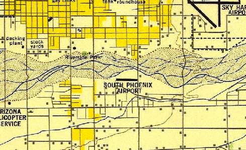
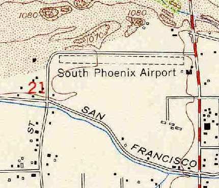
South Phoenix Airport, Phoenix, AZ
33.42, -112.05 (Southwest of Phoenix Sky Harbor Airport, AZ)
South Phoenix Airport, one of the amazing array of airfields depicted in the Phoenix area on the September 1947 Phoenix Sectional Chart.
South Phoenix Airport was apparently built at some point in 1947,
as it was not yet depicted on a 1937 aerial photo or the March 1947 Phoenix Sectional Chart.
The earliest depiction of South Phoenix Airport which has been located was on the September 1947 Phoenix Sectional Chart.
The 1947 Gila River World Aeronautical Chart depicted South Phoenix Airport as having a 2,600' paved runway.
The 1948 USAF Urban Area Chart depicted South Phoenix Airport as having a single east/west runway adjacent to the south side of the Salt River wash.
The earliest photo which has been located of the South Phoenix Airport
was a 2/17/49 aerial view (from the Maricopa County Flood Control District).
It depicted the field as having a single unpaved east/west runway,
with a total of 10 single-engine aircraft parked around a few small buildings on the southeast side of the field.
The March 1949 Phoenix Sectional chart (courtesy of Chris Kennedy) described South Phoenix Airport as having a 2,600' unpaved runway.
The 1952 USGS topo map (courtesy of Chris Kennedy) depicted South Phoenix Airport as having a single east/west runway,
along with a single building (hangar?) at the southeast corner of the field.
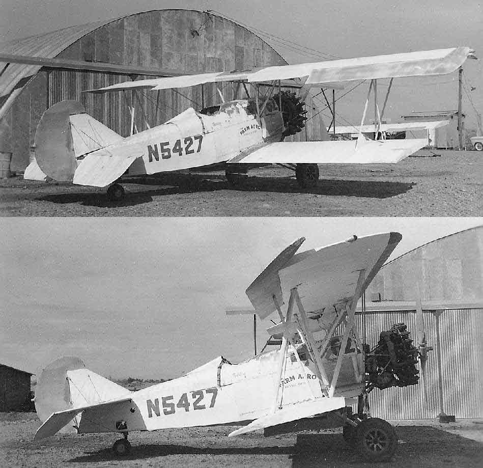
The earliest ground-level photos which have been located of South Phoenix Airport were a pair of late-1950s photos
by Brian Baker (enhanced by Bill Grasha) of a Travelaire 4000 biplane, operated as a crop duster, marked as “Farm Aero”, in front of a hangar.
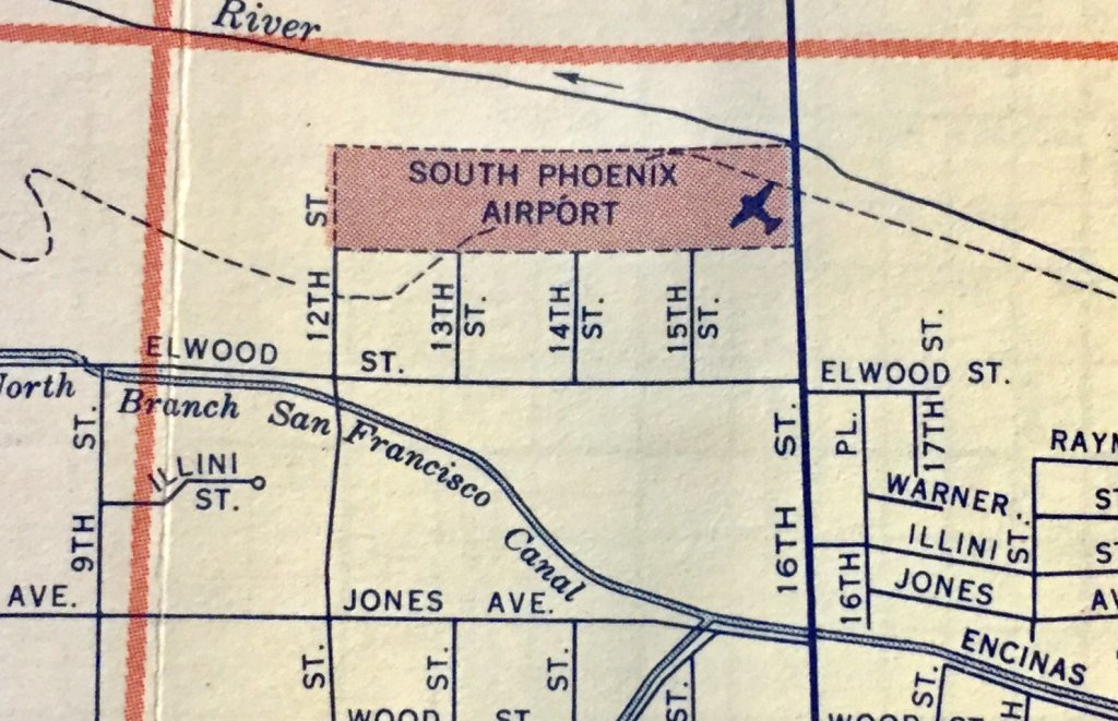
A 1958 street map (courtesy of Kevin Walsh) depicted South Phoenix Airport as an east/west rectangular property outline.
The Aerodromes table on the 1958 Phoenix Sectional chart (according to Chris Kennedy) described South Phoenix Airport as having a single 2,600' bare runway.
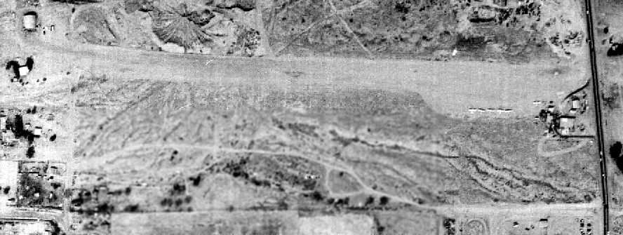
A 2/15/59 aerial view (from the Maricopa County Flood Control District)
depicted South Phoenix Airport as having a single unpaved east/west runway.
The number of aircraft visible on the field had decreased somewhat compared to the 1949 photo, to only 6.
It appears as if a building added northwest of the runway may have also served as a hangar.
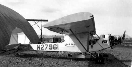
The last photo which has been located of the South Phoenix Airport
was a 1960 photo by Brian Baker of an extensively-modified Piper J3F duster, N27961, marked as “Farm Aero”, in front of a hangar.
The 1962 AOPA Airport Directory described South Phoenix Airport as having a single 3,000' bare Runway 9/27,
and listed the operator as James Wilson.
The last aeronautical chart depiction which has been located of South Phoenix Airport was on the 1962 Phoenix Sectional Chart.
It depicted South Phoenix Airport as a private airfield having a 2,600' unpaved runway.
South Phoenix Airport was evidently closed (for reasons unknown) at some point between 1962-65,
as it was not depicted on the July 1965 Phoenix Sectional Chart (courtesy of Ron Kunse),
the 1966 Phoenix Local aeronautical chart (courtesy of John Voss), or the 1969 USGS topo map.
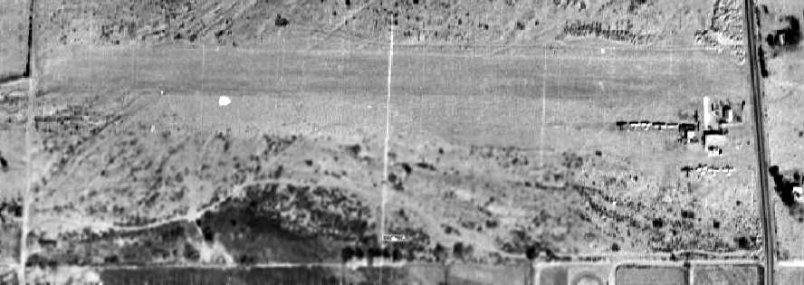
A 1969 aerial photo showed that South Phoenix Airport had been abandoned, with the runway still remaining clear,
but the former aircraft parking area having been reused for storage.
The 1997 USGS aerial photo did not show any trace of South Phoenix Airport.
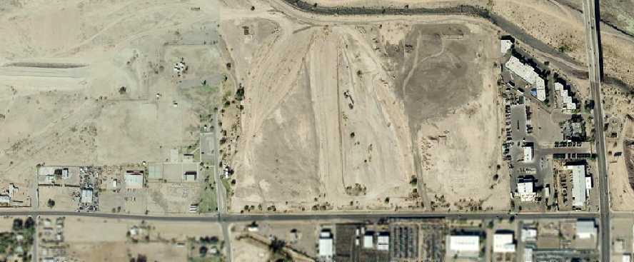
A 12/3/07 aerial view (from the Maricopa County Flood Control District) did not show any remaining trace of the South Phoenix Airport.
The site of South Phoenix Airport is located northwest of the intersection of South 16th Street & East Elwood Street.
____________________________________________________
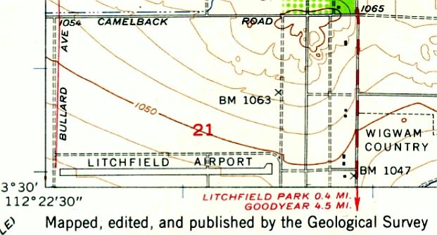
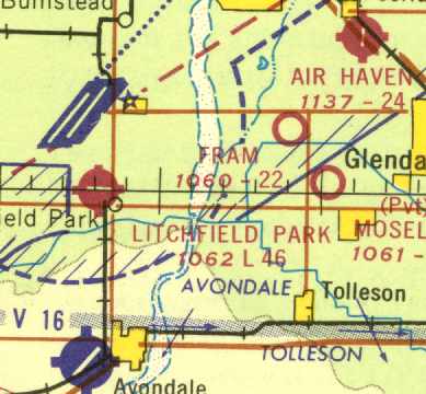
Litchfield Park Airport, Litchfield Park, AZ
33.49, -112.36 (South of Luke AFB, AZ)
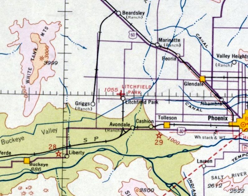
Litchfield Park Airport, as depicted on the October 1935 Phoenix Sectional Chart (courtesy of Chris Kennedy).
The Litchfield Park Airport was located south of Luke AAF & north of Goodyear Field
(which was also known as Litchfield Park Naval Air Facility, leading to some confusion).
According to John Arthur, the Litchfield Park Airport “was built in the 1930s to serve the famous Wigwam Resort.”
The earliest reference to Litchfield Park Airport which has been located
was in the 1934 Department of Commerce Airport Directory (according to Chris Kennedy),
which described it as a rectangular dirt field measuring 2,010' x 1,298', with the entire field available.
The Litchfield Park Airport was one of Phoenix's earliest airfields,
as it was one of only 2 airfields depicted in the entire Phoenix metropolitan area
on the October 1935 Phoenix Sectional Chart (Sky Harbor being the other).
Litchfield Park was depicted as an auxiliary airfield.
The earliest photo which has been located of the Litchfield Park Airport
was a 6/21/43 aerial view looking north, from the 1945 AAF Airport Directory.
It depicted the airport simply as a rectangular open area.
The 1944 US
Army/Navy Directory of Airfields (courtesy of Ken
Mercer) described Litchfield Park Airport as having a 2,300'
runway.
The 1945 AAF Airfield Directory (courtesy of Scott Murdock) described Litchfield Park Airport
as a 60 acre rectangular property within which was a 2,010' x 1,290' sand & caliche all-way field.
The field was said to have a single 200' x 140' metal hangar, and to be privately owned & operated.
The 1947 Gila River World Aeronautical Chart depicted Litchfield Park Airport as having a 3,700' paved runway.
The 1948 USGS topo map depicted Litchfield Airport.
A 1949 aerial view (from the Maricopa County Flood Control District)
depicted the Litchfield Park Airport as having a single unpaved east/west runway.
The buildings to the southeast of the runway were evidently not related to the airfield.
The Aerodromes table on the 1956 Phoenix Sectional chart (courtesy of John Voss)
described Litchfield Park Airport as having a single 3,960' oiled runway.
Brian Baker recalled, “The Litchfield Park Airport was operated by Marsh Aviation for a while in the 1950s.”
The 1957 USGS topo map depicted the Litchfield Airport as having a single paved east/west runway.
A 1958 aerial view depicted the Litchfield Park Airport possibly while the runway was being paved, as only the eastern third was paved.
A dozen light aircraft were visible parked on the south side of the field.
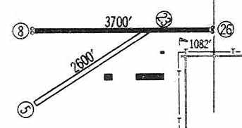
The 1960 Jeppesen Airway Manual (courtesy of Chris Kennedy)
depicted the Litchfield Park Airport as having a single 3,700' paved Runway 8/26 & a 2,600' unpaved Runway 5/23.
A total of 3 buildings (hangars?) were depicted along the southeast side of the field.
The 1962 AOPA Airport Directory described the field as having a single 3,715' oiled Runway 9/27,
and listed the operator as Marsh Aviation Company, Inc.
On the 1966 Phoenix Local Aeronautical Chart (courtesy of John Voss), Litchfield Park Airport was depicted as having single 4,520' paved Runway 8/26.
The last chart depiction which has been located of the Litchfield Park Airport
was on the July 1968 Phoenix Sectional Chart (courtesy of David Brooks).
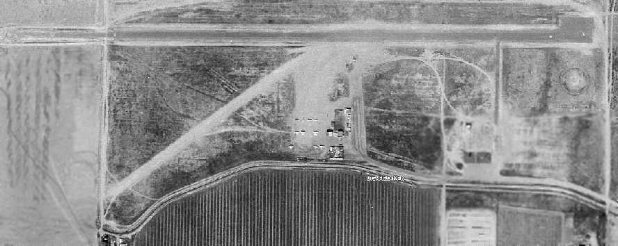
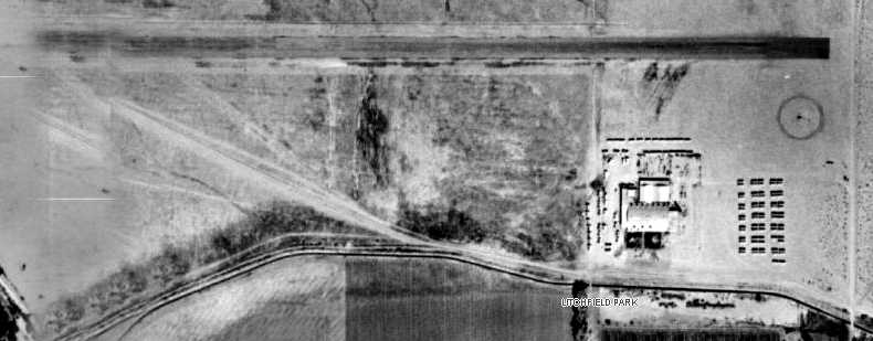
The last photo which has been located of the Litchfield Park Airport was a 1969 aerial view (from the Maricopa County Flood Control District).
It depicted the field as having a single paved east/west runway, with a shorter crosswind unpaved runway.
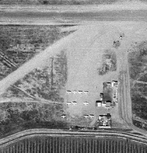
A closeup of Litchfield Park Airport from the 1969 aerial view (from the Maricopa County Flood Control District, courtesy of Jeff Lockridge).
It depicted a total of 11 single-engine aircraft parked around several small buildings on the south side of the field.
The Litchfield Park Airport apparently closed at some point in 1969,
as it was no labeled 'Abandoned Airport” on the January 1969 Phoenix Sectional Chart.
Its closure was no doubt hastened by its extreme proximity to Luke AFB to the north, which must have eventually proved to be unworkable.
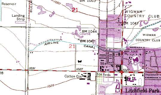
The 1982 USGS topo map still depicted a mere 600' "Landing Strip", extending west from Bullard Avenue.
Apparently the runway used to continue to the east, before it was bisected by Bullard Avenue.
An additional clue on the topo map to the property's previous life is the name of the canal just southeast of the "Landing Strip" - labeled "Airline Canal".
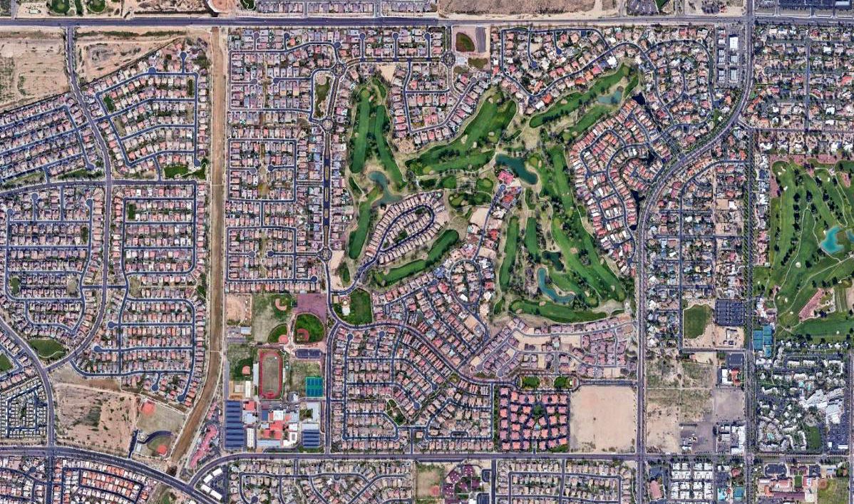
A 2019 aerial view showed no trace remaining of the Litchfield Park Airport.
The site of Litchfield Park Airport is located southwest of the intersection of Camelback Road & Litchfield Road.
____________________________________________________
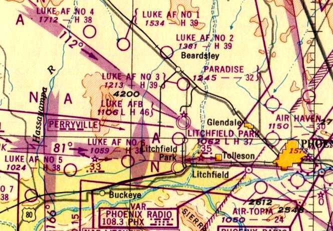
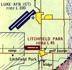
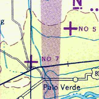
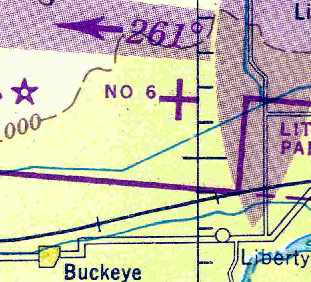
Luke Auxiliary Army Airfield #7 / Hassayampa Field, Buckeye, AZ
33.37, -112.76 (Southwest of Luke AFB, AZ)
A 6/23/43 aerial view looking north at “Luke Field Auxiliary #7 (Hassayampa Field)”
from the 1945 AAF Airport Directory (courtesy of Scott Murdock).
This airfield was built during WW2 as one of a large number of satellite airfields for Luke AAF,
which was the largest single-engine advanced training base in the world during WW2.
According to a 1992 Army Corps of Engineers Report, the property for Hassayampa Field encompassed a total of 612 acres.
According to the "History of Luke AFB" (obtained by David Brooks from the public affairs office at Luke AFB),
"Hassayampa Field, Number 7, had only 2 runways, both having the 300' x 4,000' dimensions.
Despite having only 2 runways, Hassayampa Field’s airdrome construction cost amounted to $237,000."
Field #7 was "built during the period July - August 1942."
The earliest depiction of Hassayampa Field which has been located
was a 6/23/43 aerial view looking north at “Luke Field Auxiliary #7 (Hassayampa Field)” from the 1945 AAF Airport Directory (courtesy of Scott Murdock).
It depicted the field as having 2 asphalt runways connected by a taxiway.
Hassayampa Field was not yet depicted on the March 1944 Phoenix Sectional Chart.
The earliest aeronautical chart depiction of Hassayampa Field which has been located
was on the March 1945 Phoenix Sectional Chart (courtesy of Chris Kennedy).
The 1945 AAF Airfield Directory (courtesy of Scott Murdock) described “Luke Field Auxiliary #7 (Hassayampa Field)”
as a 612 acre trapezoidal property within which were two 4,000' bituminous runways, oriented NNE/SSW & northeast/southwest.
The field was said to not have any hangars, and to be operated by the Army Air Forces.
The 1947 Gila River World Aeronautical Chart depicted Luke AF #7 as having a 3,800' paved runway.
Hassayampa Field was declared excess in 1948 (according to the Army Corps of Engineers).
A 2/20/49 aerial view (from the Maricopa County Flood Control District) depicted Hassayampa Field as having 2 paved runways,
oriented north/south & northeast/southwest, along with a connecting taxiway.
Unlike many of the other WW2-era Arizona auxiliary airfields, there did not appear to have been any parking ramp (or any other improvements).
Hassayampa Field was reestablished by the Air Force in 1950,
but was once again declared excess in 1955 (according to the Army Corps of Engineers).
However, "Luke AF #7" was still depicted as an active airfield on the 1956 Phoenix Sectional chart (courtesy of John Voss).
Hassayampa Field remained intact as seen on a 1958 aerial photo.
The last aeronautical chart depiction showing the Luke Auxiliary Field #7 being operational was on the March 1961 Phoenix Sectional.
It depicted “Luke” airfield as not having any military connection, and having 2 paved runways, with the longest being 3,800'.
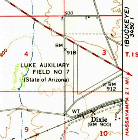
The 1962 USGS topo map depicted “Luke Auxiliary Field #7 (State of Arizona)” as having 2 paved runways.
Hassayampa Field was apparently closed again at some point between 1961-64,
as the site was marked "Abandoned Airport" on the 1964 Phoenix Sectional Chart (according to Chris Kennedy).
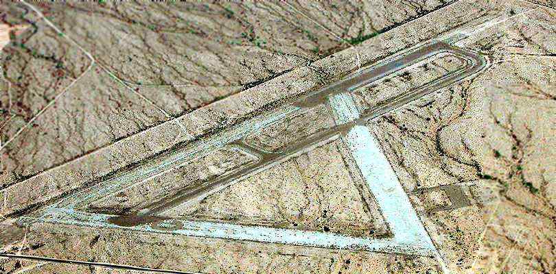
A 1992 USGS aerial view looking north showed the former Hassayampa Field remained intact.
Hassayampa Field appeared basically unchanged in a 1996 aerial photo.
At some point between 1996-98 a set of storage buildings were built adjacent to the southeast side of the airfield,
as depicted in a 1998 aerial photo.
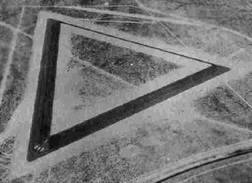
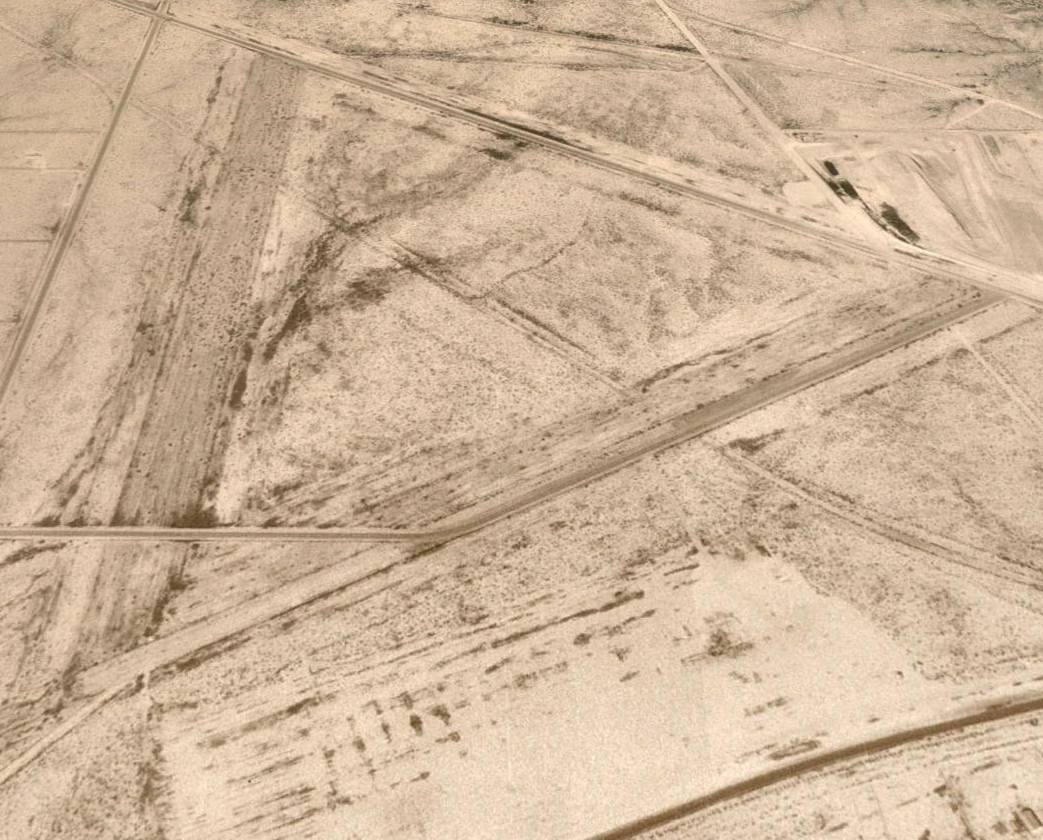
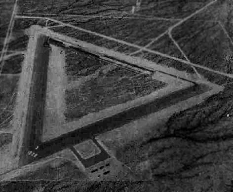
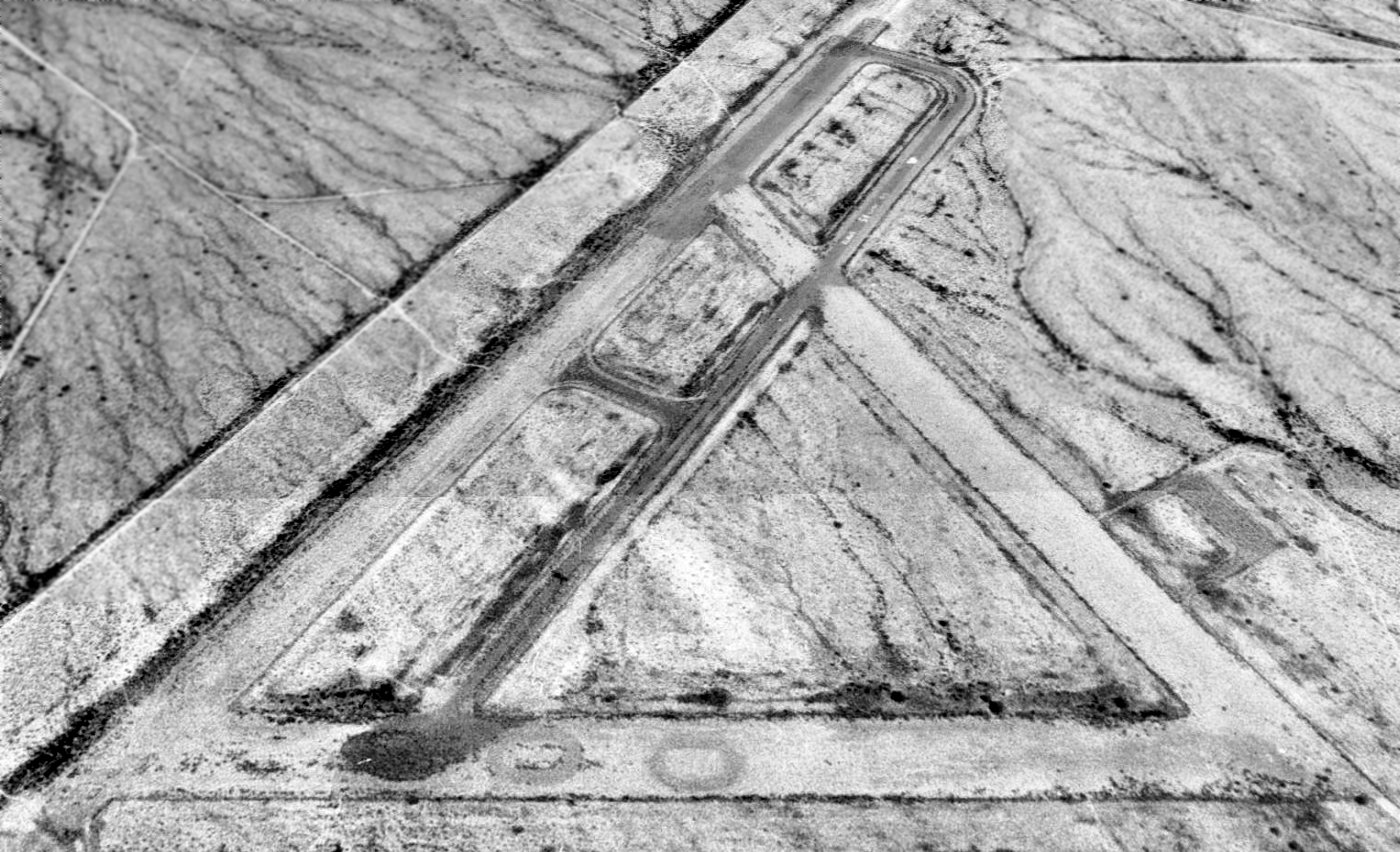
A 2002 aerial view © 2002 by AirNikon (used by permission) looking southwest at Hassayampa Field.
The remains of the two 4,000' runways & connecting taxiway are still perceptible.
As of 2002, the property of Hassayampa Field was owned by Maricopa County & several private parties.
The county-owned Hassayampa landfill on the northeast portion of the site was listed as a federal Superfund site.
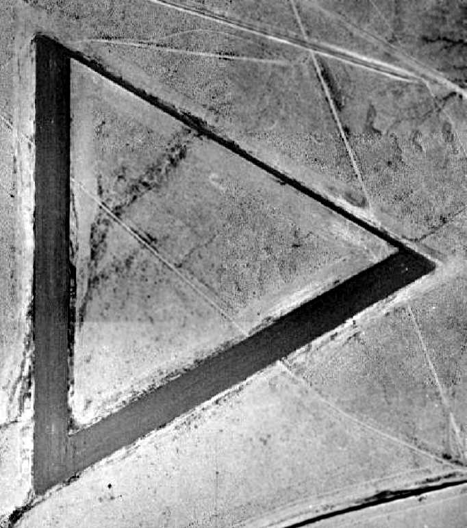
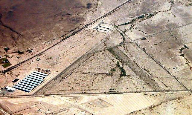
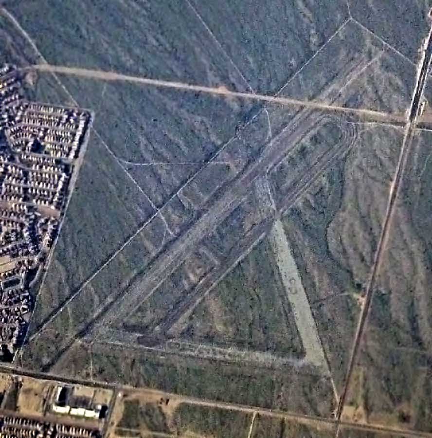
A 2014 aerial view looking north showed the former Hassayampa Field was covered with industrial buildings,
with only the overall triangular airfield layout still recognizable.
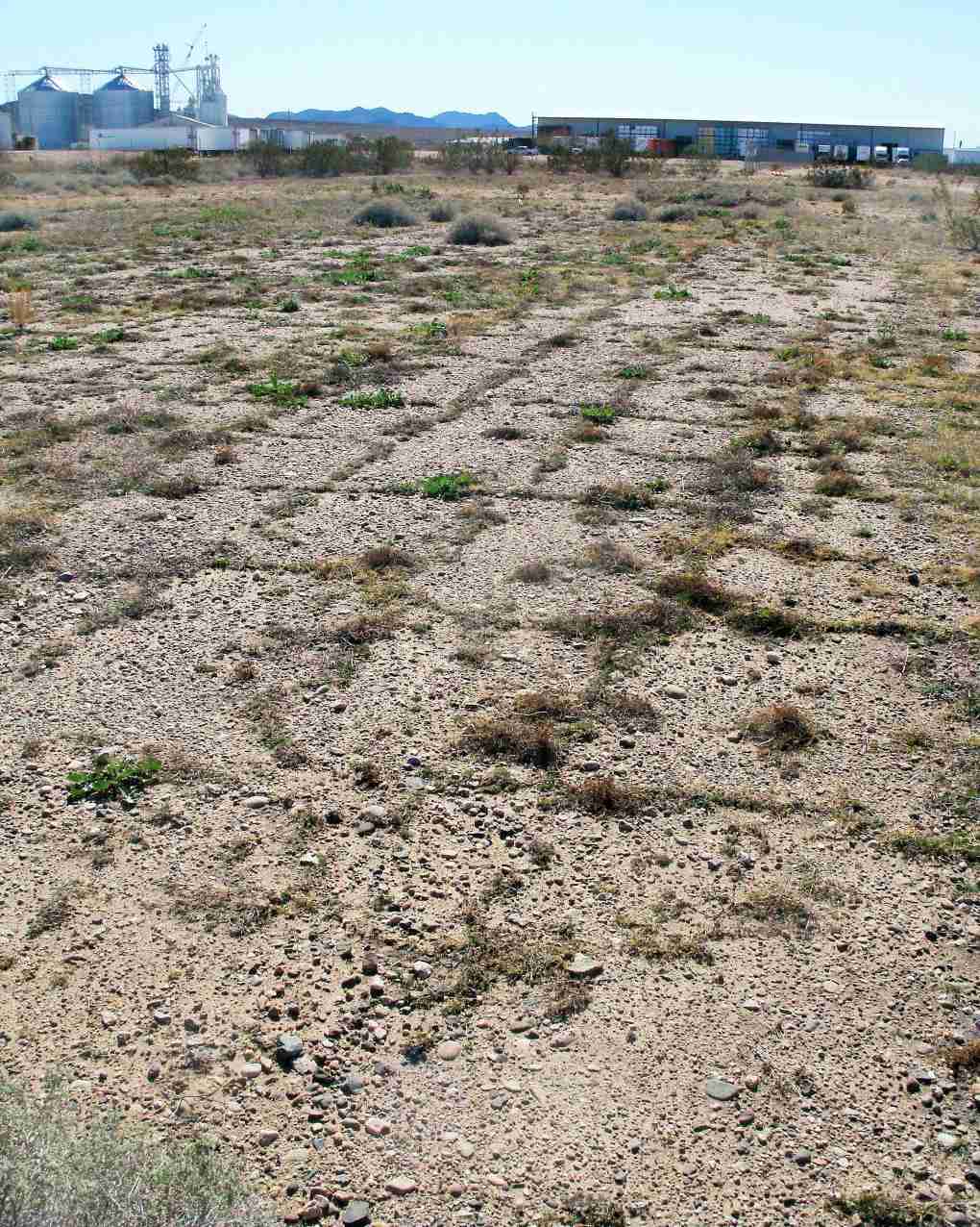
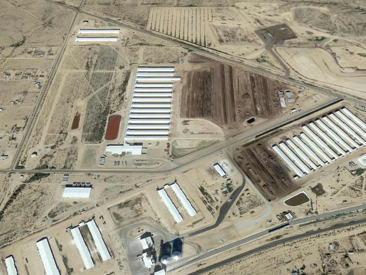
A 2/2/16 photo by Mike Jamison, of “traces of Luke Aux Field 7's only remaining runway, looking southward.
A fence separates active agricultural buildings in the distance from the runway, which locals now use for off-road vehicle recreation.”
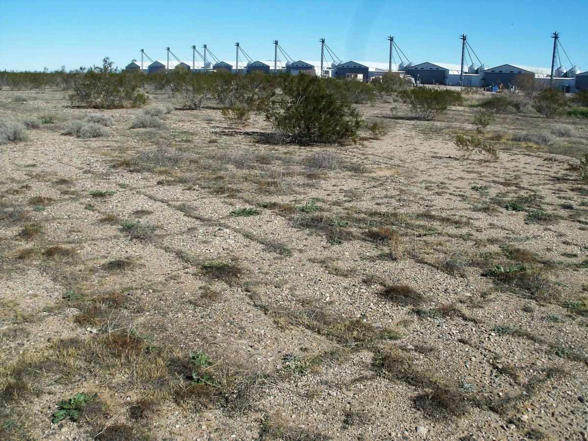
A 2/2/16 photo by Mike Jamison, who reported, “Northern-looking view of Luke Aux Field 7's last runway.
Newly constructed agricultural buildings starkly contrast modern times with yesteryear.
The runway as yet remains undeveloped, and lies behind a protective fence.”
Hassayampa Field is located west of the intersection of West Salome Highway & Ward Road,
____________________________________________________
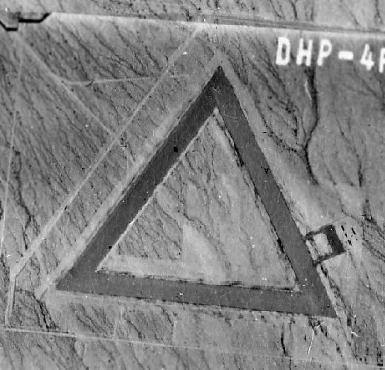
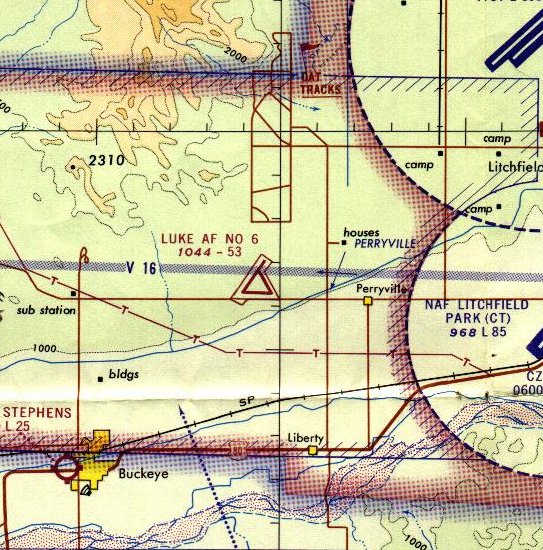
Luke Field Auxiliary Airfield #6 / Goodyear Field / Luke Air Force Auxiliary Airfield #6, Goodyear, AZ
33.44, -112.52 (Southwest of Luke AFB, AZ)
A 6/23/43 aerial view looking north at “Luke Field Auxiliary #6 (Goodyear Field)”
from the 1945 AAF Airport Directory (courtesy of Scott Murdock).
Goodyear Field was built in 1943 as one of a large number of satellite airfields for Luke AAF,
which was the largest single-engine advanced training base in the world during WW2.
According to a 1992 Army Corps of Engineers Report, the Goodyear Field property consisted of a total of 1,159 acres.
According to the "History of Luke AFB" (obtained by David Brooks from the public affairs office at Luke AFB),
Goodyear Field (#6) had three 4,000' x 300' runways, and the construction costs for its airdrome was $263,000.
Among Luke's auxiliary airfields, "Fighter & Goodyear Fields boasted the most facilities,
each having separate buildings for crew chiefs, operations, supply, barracks, pit latrine, crash truck shed, generator shed & a control tower.
Building construction cost totaled $24,300."
The earliest depiction of Goodyear Field which has been located was a 6/23/43 aerial view looking north from the 1945 AAF Airport Directory (courtesy of Scott Murdock).
It depicted the “Luke Field Auxiliary #6 (Goodyear Field)” as having 2 paved runways connected by a taxiway.
Goodyear Field was not yet depicted on the March 1944 Phoenix Sectional Chart.
The earliest aeronautical chart depiction of Goodyear Field which has been located
was on the March 1945 Phoenix Sectional Chart (courtesy of Chris Kennedy).
The 1945 AAF Airfield Directory (courtesy of Scott Murdock) described “Luke Field Auxiliary #6 (Goodyear Field)”
as a 940 acre rectangular property within which were three 4,000' bituminous runways,
oriented NNE/SSW, ENE/WSW, and northwest/southeast.
The field was said to not have any hangars, and to be operated by the Army Air Forces.
Luke AF #6 was depicted on the 1947 Gila River World Aeronautical Chart as having a 3,800' paved runway.
A 1949 aerial photo (courtesy of John Arthur) depicted Goodyear Field in its original configuration,
with 3 runways & a parking ramp on the southeast side.
What may have been several small buildings were just east of the parking ramp.
The site was declared excess & deeded to the State of Arizona in 1949,
but was then reestablished & expanded by the Air Force later that same year.
It was last used for emergency landings, dart target launchings, and as an emergency drop zone for flight training missions from Luke AFB.
At some point between 1949-56 the the northeast/southwest runway was lengthened toward the northeast,
as the 1956 Phoenix Sectional chart (courtesy of John Voss)
depicted "Luke AF #6" as an active with the longest runway as being a 5,300' hard-surfaced strip .
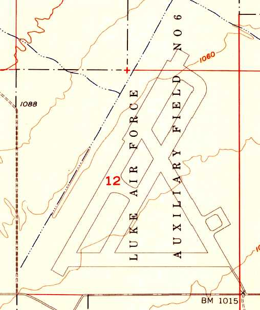
The 1957 USGS topo map depicted Luke AF Aux #6 as having 3 paved runways, taxiways, and a small ramp.
The Army Corps of Engineers indicated that the Luke AF Aux #6 site was declared excess in 1957.
"Luke AF #6" was still depicted as an active airfield on the 1966 Phoenix Local aeronautical chart (courtesy of John Voss).
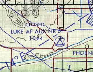
Luke AF Aux #6 was evidently closed at some point between 1966-71,
as it was labeled "closed" on the August 1971 USAF Tactical Pilotage Chart (courtesy of Chris Kennedy).
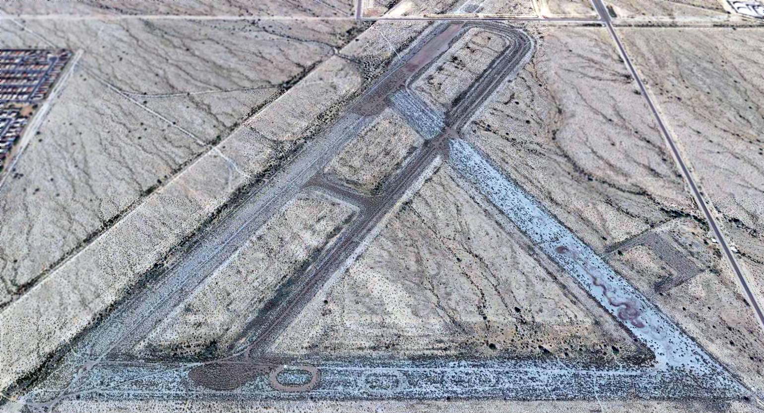
A 1992 aerial view looking north at the remains of Luke Aux #6.
Aerial view of of Luke Aux #6 © 2002 by AirNikon, used by permission.
As of 2002, the Luke Aux #6 property was owned by the State of Arizona & a number of private individuals.
A February 2008 aerial view by Paul Freeman (enhanced by Bill Grasha) looking northwest at the remains of Luke Aux #6,
showing the remains of the 3 paved runways.
A 2014 aerial view looking north at the remains of Luke Aux #6 showed a road had been built across the northern end of the northeast/southwest runway.
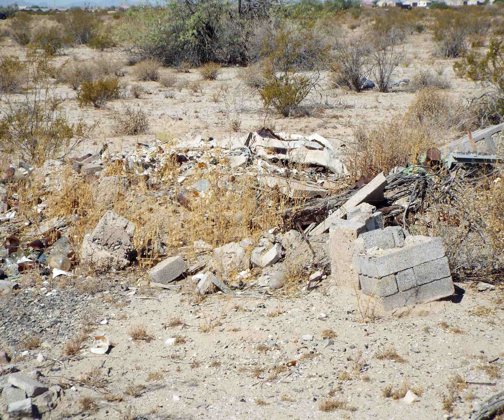
A 2017 photo (courtesy of Kevin Walsh) of USAAF building remains at the site of Luke Aux #6.
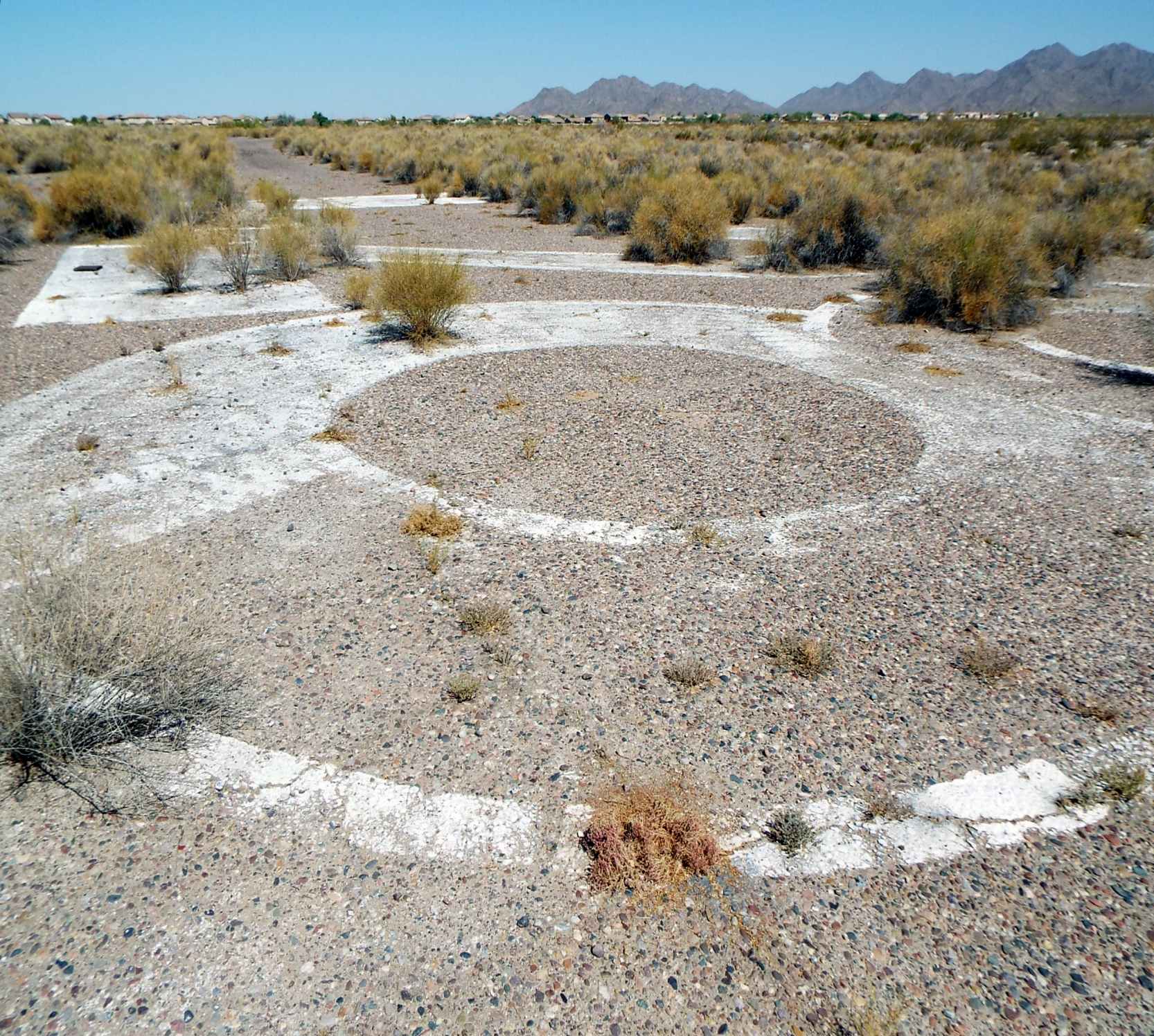
A 2017 photo (courtesy of Kevin Walsh) of the remains of runway markings at the site of Luke Aux #6.
____________________________________________________
____________________________________________________
This site covers airfields in all 50 states.