Abandoned & Little-Known Airfields:
Arizona: Northeastern Phoenix area
© 2002, © 2025 by Paul Freeman. Revised 1/26/25.
____________________________________________________
Please consider a financial contribution to support the continued growth & operation of this site.
Casa Blanca Airport (revised 12/18/22) - Motorola Airfield (revised 5/18/21) - North Phoenix Airport / Cactus Development Inc. Airport (revised 5/18/21) - Sky-Hi Pioneer Airport (revised 1/26/25)
____________________________________________________
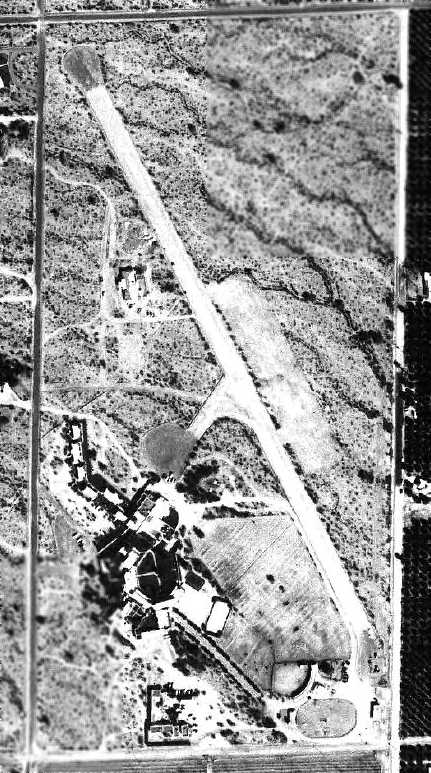
Sky-Hi Pioneer Airport, Phoenix, AZ
33.673, -112.001 (Northeast of Central Phoenix, AZ)
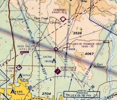
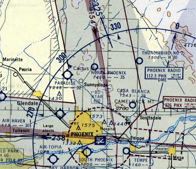
Sky-Hi Pioneer Airport, as depicted on the June 1969 Phoenix Sectional Chart.
Sky-Hi Pioneer Airport, a small general aviation airport conducting skydiving operations, was evidently established at some point between 1967-69,
as it was not yet depicted on the July 1965 Phoenix Sectional Chart (courtesy of Ron Kunse) or a 1967 aerial photo.
The earliest depiction which has been located of Sky-Hi Pioneer Airport was on on the June 1969 Phoenix Sectional Chart.
It depicted Sky-Hi Pioneer Airport as a private airfield having a 2,500' unpaved runway.
Also note that it evidently depicted the airport's location erroneously, about a mile northeast of where it was depicted on the 1969 aerial photo & subsequent aeronautical charts.
No airfield was depicted at this presumably erroneous location on the 1969 aerial photo.

The earliest photo which has been located of Sky-Hi Pioneer Airport was an 8/10/69 USGS aerial view.
It depicted a newly-graded northeast/southwest unpaved runway, with a circular skydiving drop zone to the east of the runway, but there did not appear to be any buildings.
Another 1969 aerial photo depicted 1 light single-engine aircraft parked on the northeast side of the field.
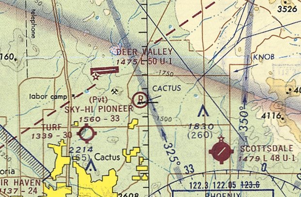
The June 1971 Phoenix Sectional Chart depicted Sky-Hi Pioneer Airport as a private airfield having a 3,300' unpaved runway,
and it depicted it in the same location as the aerial photos & subsequent aeronautical charts.
Karl Priggee recalled, “Sky-Hi Pioneer Airport... A friend made his first jump (skydiving) there in ~1972.”
Sky-Hi Pioneer Airport was not depicted on the 1973/82/94 USGS topo maps.
The 1977 Phoenix Sectional Chart depicted Sky-Hi Pioneer Airport as a private airfield having a 3,300' unpaved runway.
A 1979 aerial view depicted 1 light single-engine plane parked on the east side of Sky-Hi Pioneer Airport.
Karl Priggee recalled, “Sky-Hi Pioneer Airport... I jumped (skydiving) there in 1979 or 1980.”
The last photo which has been located showing an aircraft at Sky-Hi Pioneer Airport was a 1981 aerial view, which depicted 1 light single-engine plane parked on the east side.
A 1982 aerial view did not depict any aircraft at Sky-Hi Pioneer Airport.
The last aeronautical chart depiction which has been located of Sky-Hi Pioneer Airport was on November 1985 Phoenix Sectional Chart,
which depicted it as a private airfield having a 2,100' unpaved runway, and conducting parachute operations.
Strangely, Sky-Hi Pioneer Airport was no longer depicted on the 1988 Phoenix Sectional Chart (courtesy of Jonathan Westerling),
but its parachute drop zone still was.
Sky-Hi Pioneer Airport was evidently closed (for reasons unknown) at some point between 1985-93,
as it was no longer depicted on the May 1993 Phoenix Sectional Chart (courtesy of Ron Plante).
Sky-Hi Pioneer Airport was evidently closed (for reasons unknown) at some point between 1985-93,
as it was no longer depicted on the May 1993 Phoenix Sectional Chart (courtesy of Ron Plante).
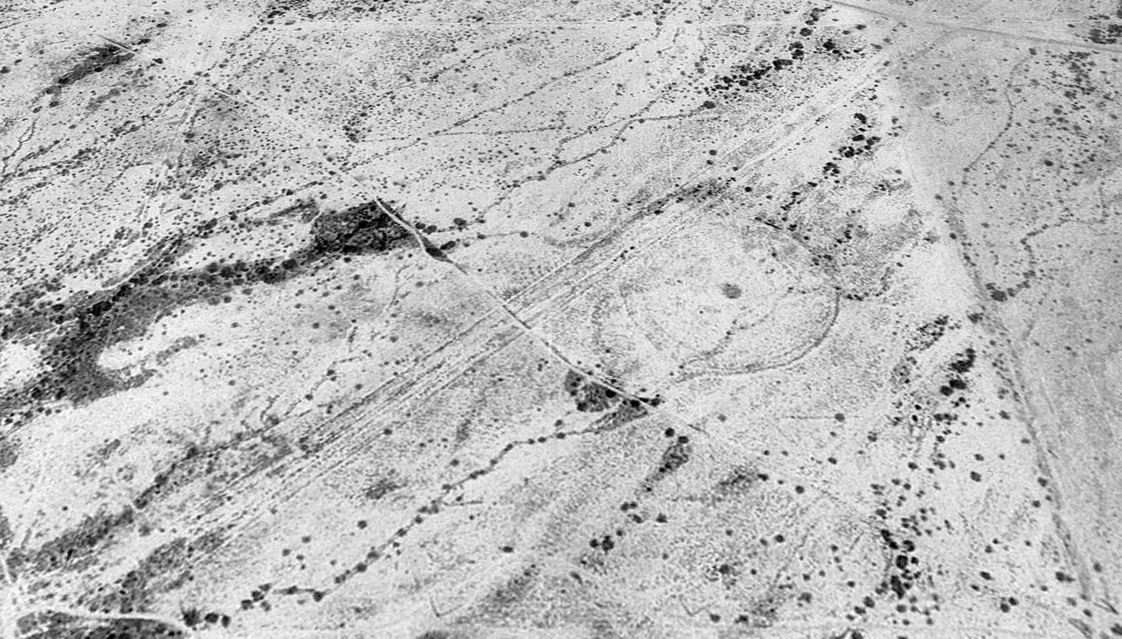
A 1997 aerial view looking north depicted Sky-Hi Pioneer Airport's runway & drop zone as remaining intact though deteriorated.
A 1998 aerial view show construction for the Pima Freeway cutting across the middle of the Sky-Hi Pioneer Airport runway,
but portions remained recognizable to the northeast & southwest.
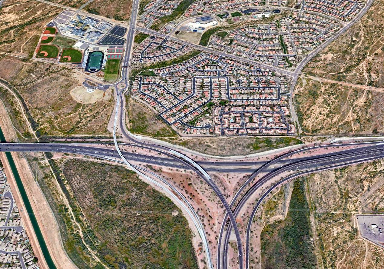
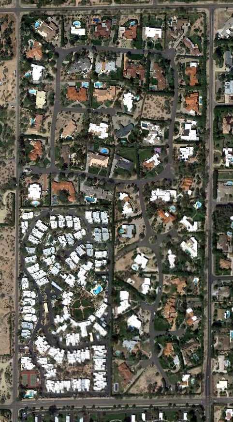
A 2019 aerial view looking north showed no trace remaining of Sky-Hi Pioneer Airport, with the site covered by housing, the Pima Freeway, and the Piestewa Freeway.
Thanks to Karl Priggee for pointing out this airfield.
____________________________________________________
Motorola Airfield, Scottsdale, AZ
33.46, -111.9 (Northeast of Phoenix, AZ)
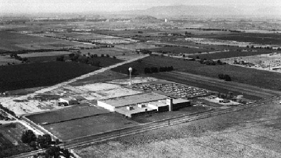
A 1959 aerial view of the Motorola Airfield.
No airfield was yet depicted at this location on a 1955 aerial photo.
According to Dave Strieter, the facility was “the Motorola Government Electronics Division. The original building was built in 1955.”
The earliest depiction which has been located of the Motorola Airfield was on a 1957 aerial view,
which depicted a single unpaved northeast/southwest runway located to the south of the Motorola plant.
The runway was marked with a closed “X” symbol on each end, presumably to deter uninvited landings to this private airfield.
Two light aircraft were parked adjacent to the south side of the plant.
The Motorola Airfield was not depicted on the 1958/60/65 Phoenix Sectional Charts.
A 1959 aerial view depicted the Motorola Airfield in the same configuration.
A 5/18/61 USGS aerial view showed both ends of the Motorola Airfield runway painted with a closed-runway “X” symbol,
and no aircraft were visible on the field.
A 1962 aerial view looking west at the Motorola Airfield (courtesy of Dave Strieter)
depicted 3 light aircraft parked on the ramp adjacent to the south side of the industrial plant.
According to Dave Strieter, “Rumor has it that the tower on the front of the building (right side in the photo) served as a control tower for the airstrip,
since there is a row of what look like windows around the top of the tower.”
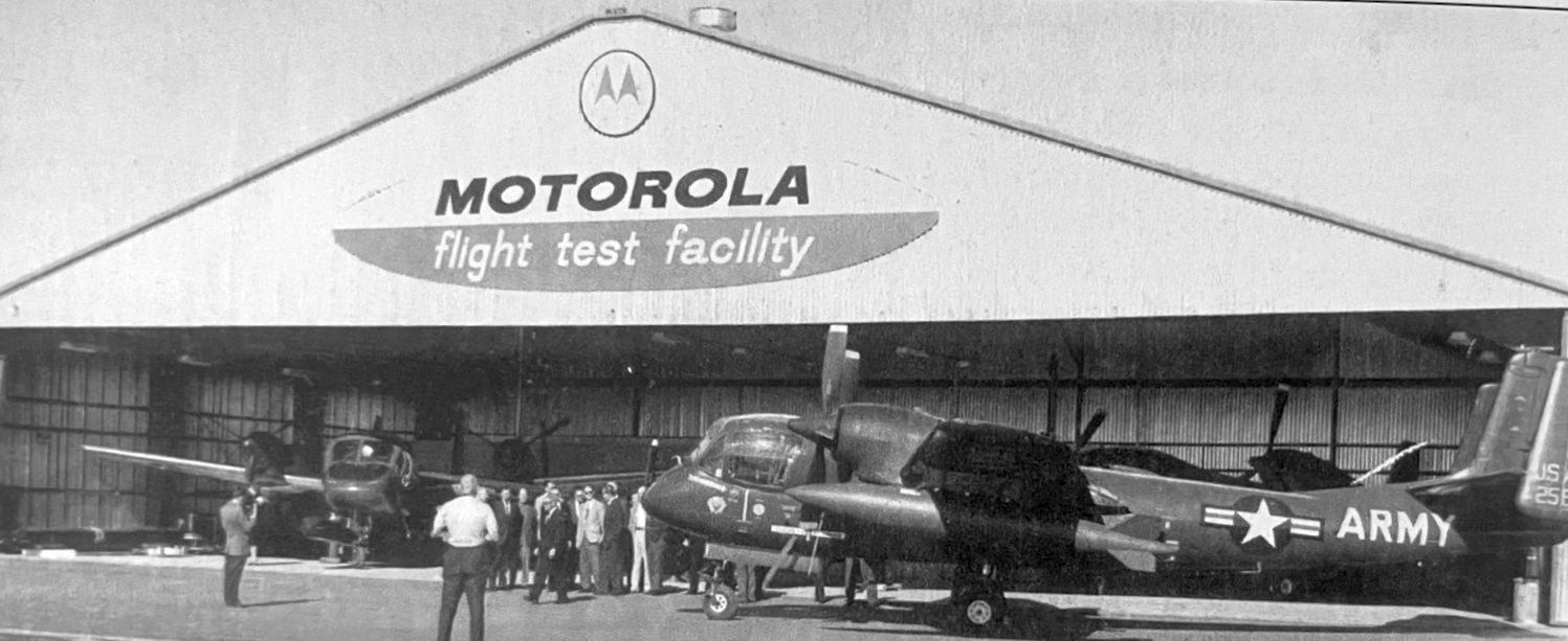
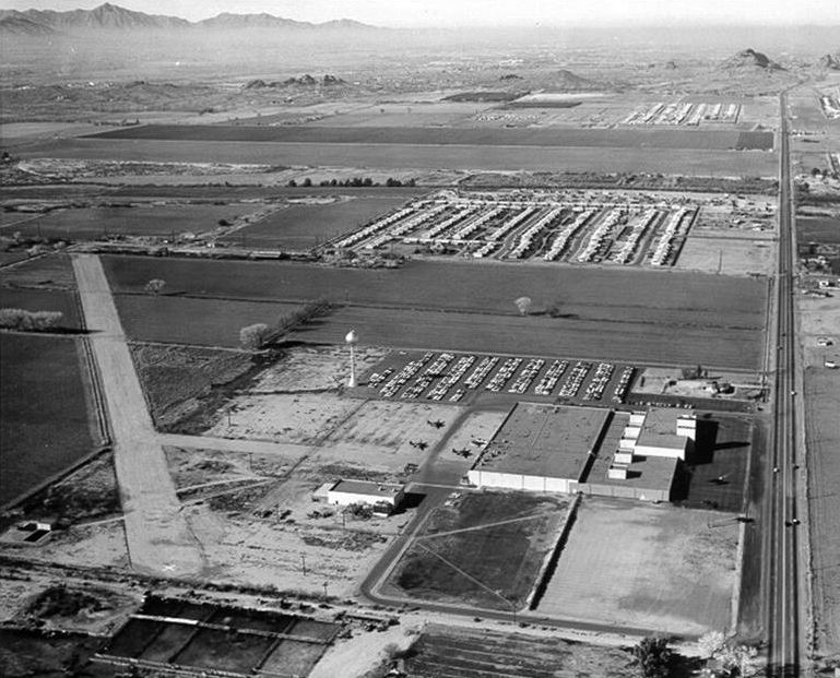
A circa 1960s photo of 3 Army Grumman OV-1 Mohawks in front of a hangar marked “Motorola Flight Test Facility” (courtesy of Kevin Walsh).
An undated (pre-1964) aerial view looking southwest at the Motorola Airfield (courtesy of Dave Strieter).
The Motorola Airfield was not depicted on the 1966 Phoenix Local Aeronautical Chart.
The Motorola Airfield was removed at some point between 1962-67,
as a 1967 aerial view showed an expanded parking lot covered the north portion of the former airfield,
and all traces of the runway had been removed from the southern portion.
Dave Strieter recalled, “I worked for General Dynamics in that building (which is about 4 times as large now) from 2005-2013.”
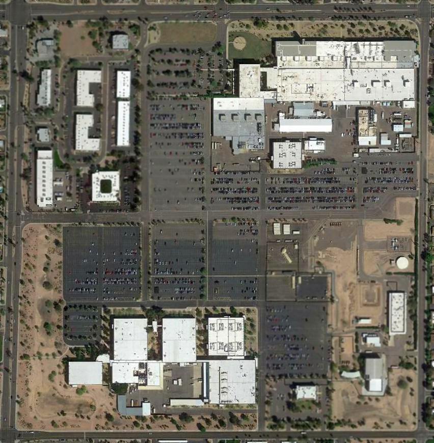
A 2015 aerial view shows the Motorola / General Dynamics plant remains, but there is no remaining trace of its airfield.
The site of Motorola Airfield is southwest of the intersection of East McDowell Road & North Granite Reef Road.
Thanks to Dave Strieter for pointing out this airfield.
____________________________________________________
Casa Blanca Airport, Scottsdale, AZ
33.52, -111.93 (Northeast of Phoenix, AZ)
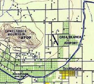
Casa Blanca Airport, as depicted on the 1948 USAF Phoenix Urban Area Chart (courtesy of Scott O'Donnell).
According to Ron Chavez's book “The Valley's Airports of the Past”,
“The Casa Blanca Inn started out as a winter home built by D. Kellogg, a renowned artist
who decided to build a summer home near Camelback Mountain in the 1930s.
After the home had been constructed, owner D. Kellogg passed away.”
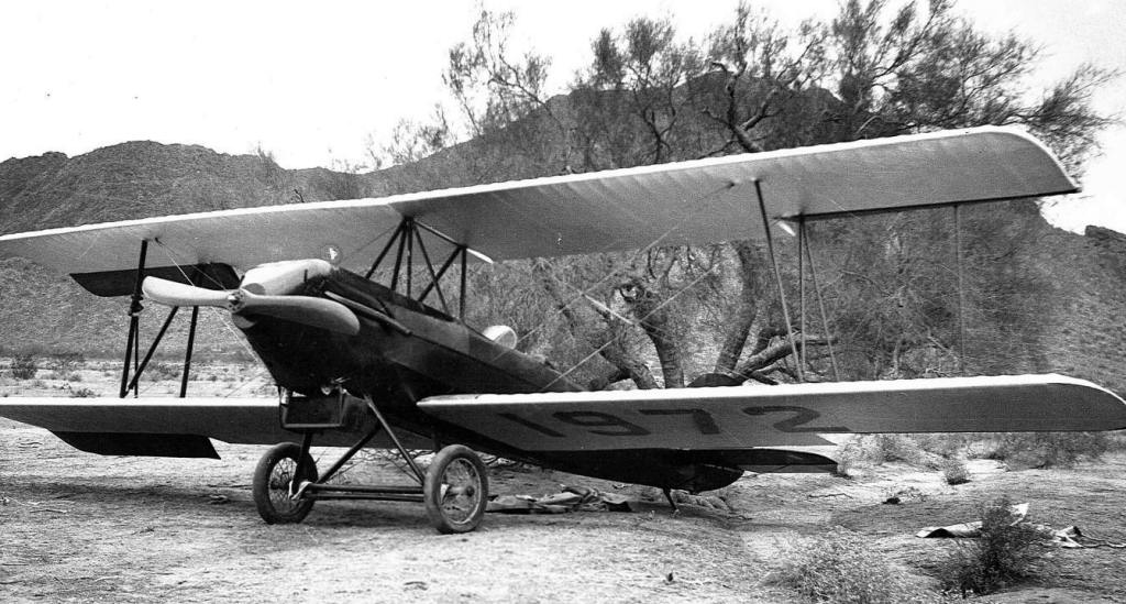
The earliest depiction which has been located of the Casa Blanca Airport
was a circa 1938 of a Long wing Eaglerock biplane parked in the desert near the Casa Blanca airstrip.
According to Ron Chavez's book “The Valley's Airports of the Past”,
In 1943, G. Borg, the inventor of the automatic transmission, took over the property for a winter home for himself & his wife.
Borg wanted a place where the executives of his company could stay for rest & relaxation.
Borg had an extra wing constructed onto the home in the shape of a Morocan-style dome.”
Casa Blanca Airport was not depicted on the August 1943 Regional Aeronautical Chart (courtesy of Kevin Walsh)
or the March 1945 Phoenix Sectional Chart (courtesy of Ron Plante).
According to Ron Chavez's book “The Valley's Airports of the Past”,
“In the 1940s, Borg had a 2,600' dirt airstrip that ran southeast/northwest constructed at the east end of the property
for his wife, a licensed pilot, so she could fly her private aircraft in from Wisconsin.”
The earliest chart depiction of the Casa Blanca Airport which has been located
was on the 1948 USAF Phoenix Urban Area Chart (courtesy of Scott O'Donnell),
which depicted it as having a single northwest/southeast runway.
Casa Blanca Airport was still not depicted on the 1949 Phoenix Sectional Chart (courtesy of Chris Kennedy).
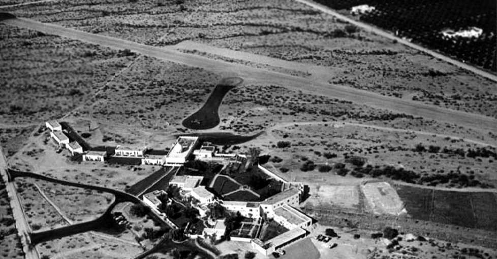
A 2/15/49 aerial view (from the Maricopa County Flood Control District)
depicted the Casa Blanca Airport as having a single unpaved northwest/southeast runway,
with a parking ramp on the east side, and a paved taxiway (on which was visible a single light aircraft)
leading to the Casa Blanca Inn to the southwest.
The earliest aeronautical chart depiction which has been located of Casa Blanca Airport was on the February 1950 Phoenix Sectional Chart.
It depicted Casa Blanca Airport as having a 2,600' unpaved runway.
Jody Smith used to live right across the street from the Casa Blanca Airport, “which was located between 64th Street & 68th Street
and bordered on the north & south by Jackrabbit Road & Chaparrel Road.
We used to watch the planes land with famous people (movie stars & such) that were staying at the Casa Blanca.
That was in the early 1950s.”
According to Ron Chavez's book “The Valley's Airports of the Past”, “In the mid-1950s the Inn was sold to R. Treadway.
The Treadways opened the resort to the general public,
but the guest list mainly included the Hollywood elite coming to Arizona.
The airstrip used by guests staying at the inn that wanted to land their personal aircraft at the Inn
to avoid the general public at Sky Harbor Airport made it an ideal getaway.
A 1957 aerial view depicted one single-engine aircraft on Casa Blanca's ramp.
Brian Baker recalled “A Phoenix strip called Casa Blanca... It was in Scottsdale just east of Camelback Mountain, and served the Casa Blanca Resort Hotel.
I went in there with a guy in an Ercoupe about 1957 or 1958, and we just barely got out of there with 2 of us in it.
It closed soon afterwards.”

The last aeronautical chart depiction which has been located of Casa Blanca Airport was on the March 1958 Phoenix Sectional chart.
It depicted Casa Blanca Airport as having a 2,800' unpaved runway.
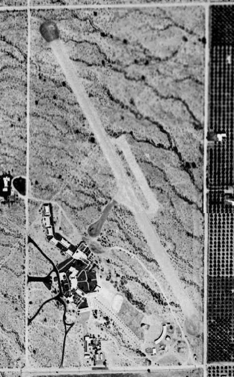
A circa 1958 aerial view looking northeast at the Casa Blanca Airfield (courtesy of the Scottsdale Public Library).
It showed the hotel buildings in the foreground, with a single aircraft on the asphalt taxiway leading to the runway.
According to Ron Chavez's book “The Valley's Airports of the Past”,
the Treadways “sold all but 20 acres of the property to a housing developer in 1958.”
Casa Blanca Airport was evidently closed at some point in 1958,
as it was no longer depicted on the September 1958 Phoenix Sectional Chart.
The Casa Blanca Airfield was still intact in a 2/20/59 aerial view (from the Maricopa County Flood Control District),
but there were no aircraft visible on the field.
According to Jody Smith, "In the 1960s it was sold & the new owners walled it in & built expensive condos, etc... no more airfield."
A 1962 aerial view (from the Maricopa County Flood Control District)
showed that streets had been built over the former runway, portions of which were still recognizable.
According to Ron Chavez's book “The Valley's Airports of the Past”,
the Treadways “co-developed the remaining property [20 acres] in 1962.”
Casa Blanca Airfield was no longer depicted at all on the 1964 Phoenix Sectional Chart (according to Chris Kennedy)
nor on the 1965 USGS topo map.
A 1969 aerial view (from the Maricopa County Flood Control District)
showed that houses had covered the site, leaving no trace of the Casa Blanca Airfield.
A 3/4/11 aerial photo shows that some of the buildings of the original Casa Blanca Inn still stand on the southwest side of the site,
but no trace of the former airfield remain.
____________________________________________________
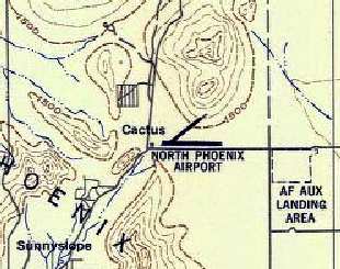
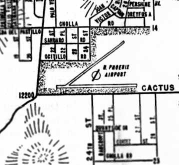
North Phoenix Airport / Cactus Development Inc. Airport, Cactus, AZ
33.6, -112.03 (North of Phoenix, AZ)
North Phoenix Airport, as depicted on the September 1945 Phoenix Sectional Chart.
According to Ron Chavez's book “The Valley's Airports of the Past”, “This airfield was constructed in late 1942,
and served as an auxiliary field for Thunderbird Airfield #2 in Scottsdale.
The airfield had 2 dirt oiled runways that were shaped in a V-pattern, oriented east/west & northeast/southwest.”
The North Phoenix Airport was not depicted on the March 1945 Phoenix Sectional Chart (courtesy of Ron Plante).
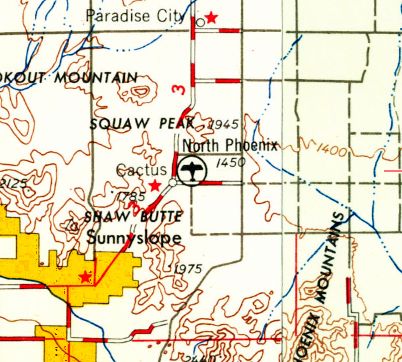
The earliest depiction which has been located of the North Phoenix Airport was on the September 1945 Phoenix Sectional Chart.
It depicted North Phoenix Airport as a commercial/municipal airport.
The 1947 Gila River World Aeronautical Chart depicted North Phoenix Airport as having a 3,500' unpaved runway.
The 1948 USAF Phoenix Urban Area Chart (courtesy of Scott O'Donnell) depicted North Phoenix Airport as having 2 runways,
with one runway appearing to go uphill, onto the slope of a small peak located just northeast of Cactus.
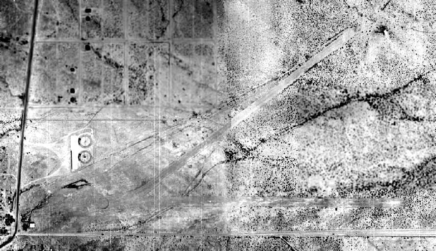
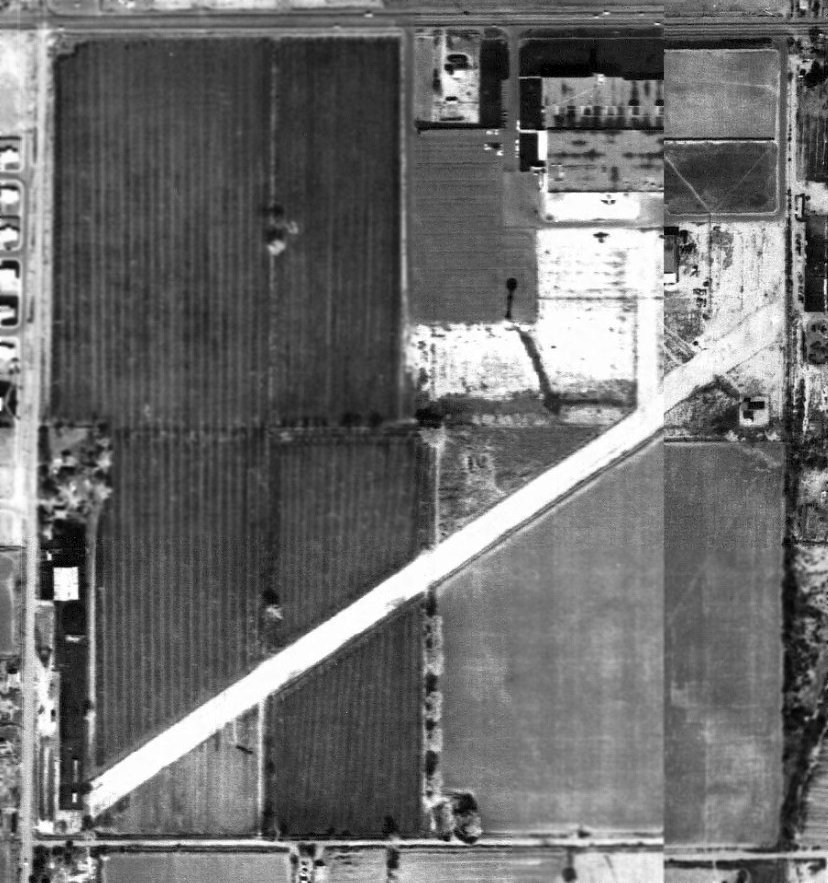
The earliest photo which has been located of the North Phoenix Airport was a 2/17/1949 aerial view (from the Maricopa County Flood Control District).
It depicted North Phoenix as having 2 unpaved runways, with a small building on the southwest corner.
![]()
It was labeled as the “Cactus Development Inc. Airport” on a 1952 Chevron street map.
The last aeronautical chart depiction which has been located of North Phoenix Airport was on the March 1956 Phoenix Sectional chart.
The Aerodromes table described North Phoenix Airport as having 2 bare runways, with the longest being 3,500'.
North Phoenix Airport was evidently closed at some point between 1956-57,
as it was no longer depicted on the May 1957 Phoenix Sectional Chart.
North Phoenix Airport, as depicted on the 1958 USGS topo map.
A 1958 aerial photo (courtesy of John Arthur) depicted the North Phoenix Airport as having 2 unpaved runways, oriented east/west & northeast/southwest.
A circa 1960 street map (courtesy of John Arthur) depicted the North Phoenix Airport as having 2 runways.
According to Ron Chavez's book “The Valley's Airports of the Past”, “In 1960 the North Phoenix Cactus Airport closed
when the property was sold to a home developer who had plans for a new housing subdivision.”
A 1962 aerial view (from the Maricopa County Flood Control District) showed that the western half of the North Phoenix Airport site had been covered with houses,
while the eastern half of the 2 runways still remained intact.
According to Ron Chavez's book “The Valley's Airports of the Past”, “In 1963 the small hangar & [part of] the 2 runways were plowed over.”
North Phoenix Airport was no longer depicted on the 1965 USGS topo map.
A 1969 aerial view (from the Maricopa County Flood Control District) showed the eastern half of North Phoenix Airport's 2 runways still remained intact.
A 1970 aerial view showed that new streets had covered the eastern half of the North Phoenix Airport east/west runway,
but the northeastern portion of the northeast/southwest runway remained recognizable.
A 1979 aerial view (from the Maricopa County Flood Control District) showed that not a trace of the former North Phoenix Airport appeared to remain,
with housing & shopping (the Cobblestone Plaza) covering all of the former airfield property.
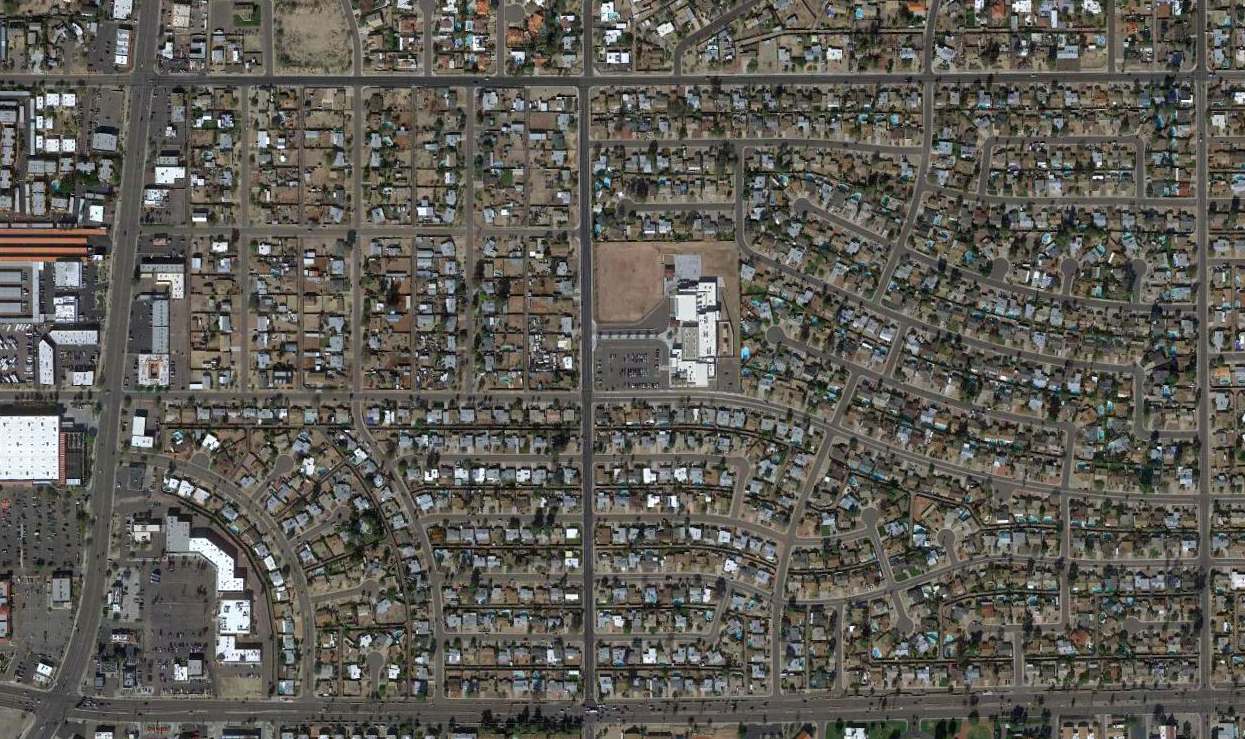
A 2016 aerial view showed no trace remaining of North Phoenix Airport.
The site of North Phoenix Airport is located northeast of the intersection of East Cactus Road & North Cave Creek Road.
____________________________________________________
____________________________________________________
This site covers airfields in all 50 states.