Abandoned & Little-Known Airfields:
Western Virginia
© 2002, © 2023 by Paul Freeman. Revised 5/19/23.
Bluefield Airport (original location) (revised 12/13/20) - Buford Airport (revised 5/19/23) - Chilhowie Intermediate Field / CAA Site 28B / Chilhowie Airport (revised 12/10/17)
Clinchfield Airport (revised 2/11/20) - Clover Airport (revised 5/19/23) - Coeburn Airport (revised 5/19/23) - Covington Clifton Forge Airport (revised 11/2/22) - Galax Airport (revised 11/2/22)
Grundy Municipal Airport / Buchanan County Airport (added 2/29/20) - Harkrader-Kilgore Airport / Bristol Airport (revised 11/2/22) - (Original) Lee County Airport / Pennington Gap Airport (revised 7/19/16)
Pulaski Intermediate Field 33B / Loving Field (revised 5/19/23) - Radford Airport (revised 2/29/20) - Richlands Municipal (revised 12/21/15)
____________________________________________________
Grundy Municipal Airport / Buchanan County Airport (KGDY), Vasant, VA
37.233, -82.125 (Southwest of Washington, DC)
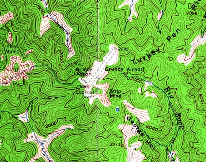
Grundy Airport, as depicted on the 1963 USGS topo map.
Grundy Airport was evidently established at some point between 1961-63,
as it was not yet depicted on the January 1961 Winston-Salem Sectional Chart,
or a 1961 aerial view, which instead depicted 2 small clearings at the eventual site of the airport.
The earliest depiction which has been located of Grundy Airport was on the 1963 USGS topo map.
It depicted Grundy Airport as having a single unpaved northeast/southwest runway,
with no buildings or other improvements.
According to Wikipedia, “Grundy Municipal Airport was completed when the property it lies on
was donated to the town by the United Coal Company, after surface mining created the new flat land.
The lack of flat terrain in the mountainous region made it difficult to find a location suitable to sustain a proper airport facility.”
The earliest aeronautical chart depiction which has been located of this airport was on the April 1965 Winston-Salem Sectional Chart.
It depicted Buchanan County Airport as having a mere 1,600' unpaved runway.
The 1977 USGS topo map continued to depicted Grundy Airport as having a single unpaved northeast/southwest runway,
but a hangar had been added along the northwest side at some point between 1963-77.
The earliest photo which has been located of Grundy Airport was a 1984 aerial view.
It depicted Grundy Airport as having a single paved northeast/southwest runway, with a hangar along the northwest side.
A 1986 aerial view depicted one light single-engine aircraft parked outside at Grundy Airport.
The earliest photo which is available of Grundy Airport was a 1998 aerial view looking northwest.
It depicted Grundy Airport as having a single asphalt Runway 4/22, with a hangar along the northwest side,
and 2 light single-engine aircraft parked in front of the hangar.
According to the FAA, for the 12-month period ending 5/31/08, Grundy Airport had an average of 11 takeoffs or landings per day.
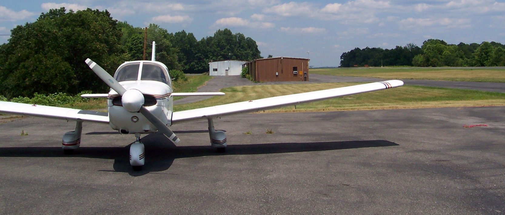
A 7/2/08 photo of a Piper Warrior in front of the Grundy Municipal Airport hangars.
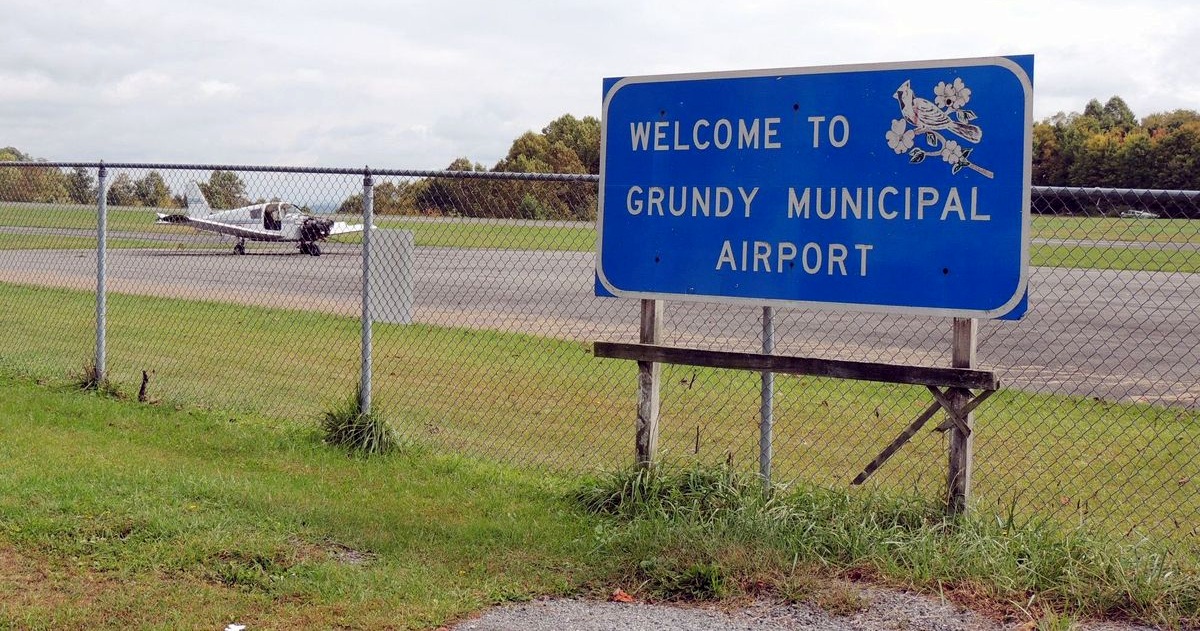
A 2012 photo of a forelorn Piper Warrior (missing a door & engine cowling) behind the Grundy Municipal Airport welcome sign.
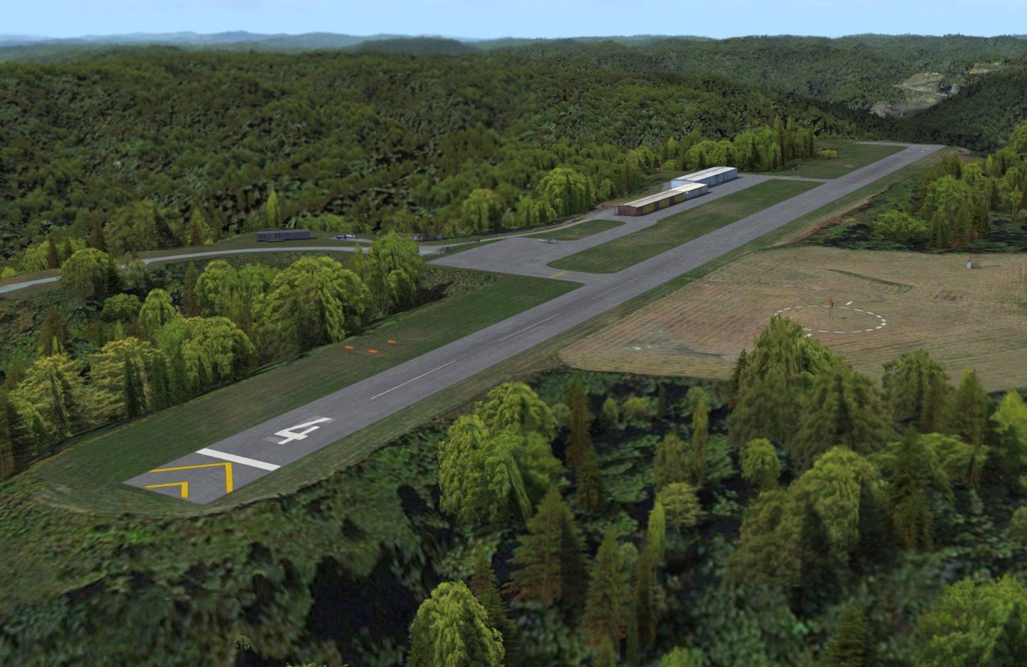
A flight simulation scenery depiction looking north at Grundy Municipal Airport.

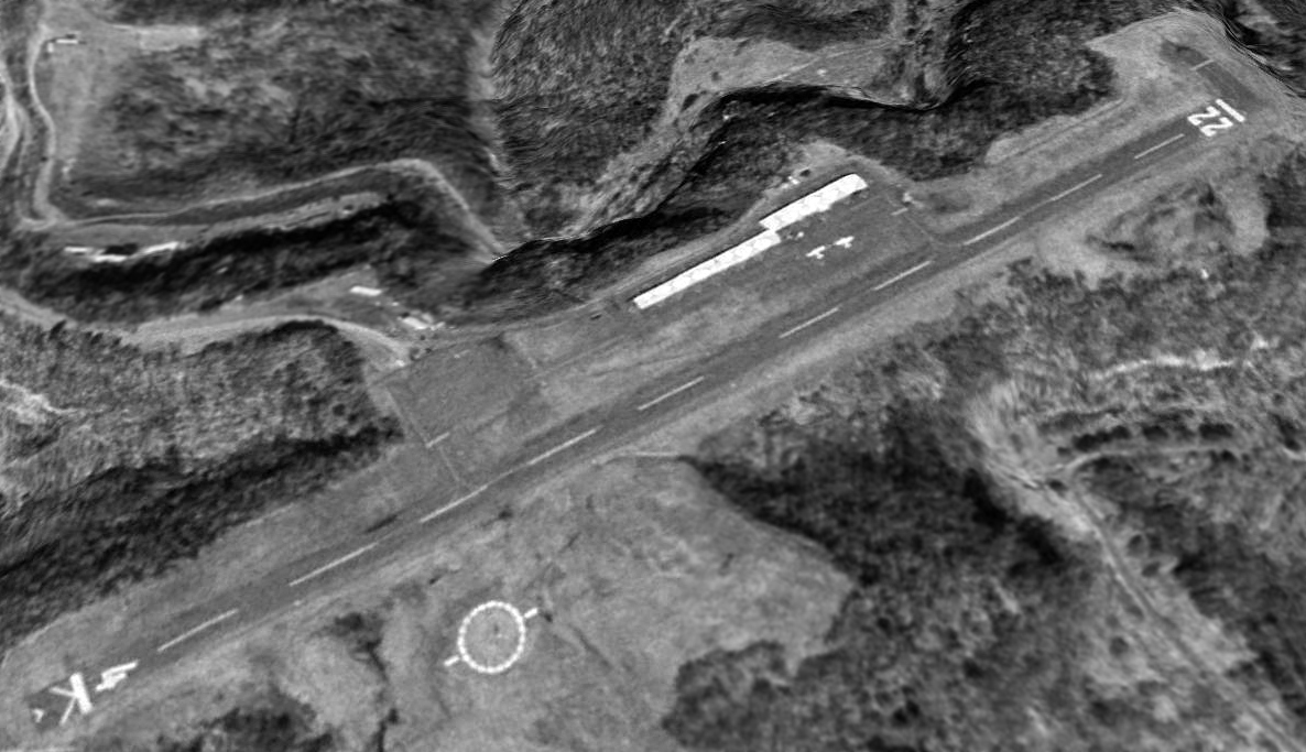
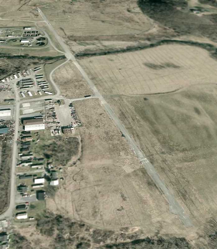
The last aerial photo which has been located of Grundy Airport was a 2018 aerial view looking northwest.
It depicted Grundy Airport as having a single asphalt Runway 4/22, with a hangar along the northwest side,
and one light single-engine aircraft parked on a paved ramp.
The last aeronautical chart depiction which has been located of Grundy Airport was on the April 2018 Cincinnati Sectional Chart.
It depicted Grundy Airport as having a single 2,200' paved northeast/southwest runway.
According to Wikipedia, Grundy Municipal Airport was owned by the town of Grundy,
and operated by the Grundy Municipal Airport Commission.
The last photos which has been located of Grundy Airport were a series of 4/16/19 photos by Tekang Wang.
This photo is looking southwest at the departure end of Grundy Airport's Runway 22, showing a Cessna 182.
Tekang reported, “There were no airplanes at the few tie-downs outside, and no one at the airport while I was there.”
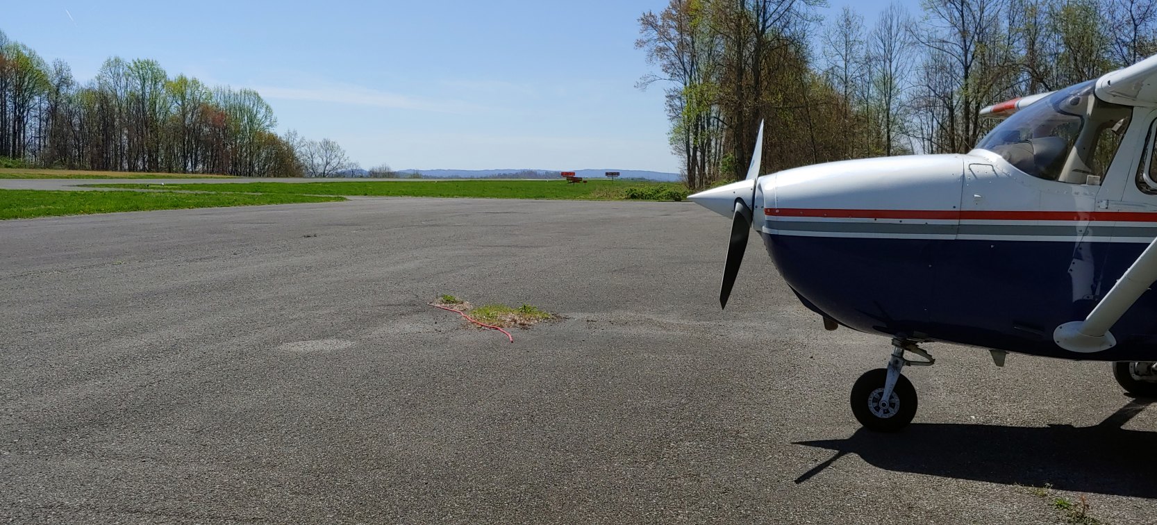
A 4/16/19 photo by Tekang Wang looking northeast toward the departure end of Grundy Airport's Runway 4.
Tekang reported, “The runway was in surprisingly good shape, and the grass & ramp areas were neat.”
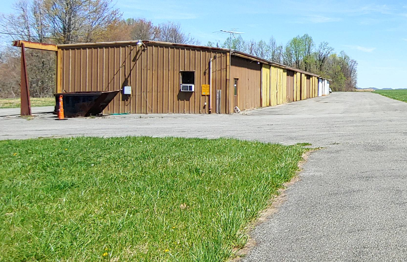
A 4/16/19 photo by Tekang Wang looking northeast at Grundy Airport's office at the end of the hangar row
Tekang reported, “The office on the end of the hangar row (room with the A/C in the window) was open, a little dusty but otherwise tidy.”
According to Wikipedia, “After 35 years of operation, many local leaders want to replace the current airport for a larger regional airport.
Leaders on a local, state, and federal level have been working on creating a new regional airport serving Buchanan & Dickenson Counties.
Currently, work is in the alpha stages to develop a new regional airport with the relocation of residents.”
According to Wikipedia, Grundy Municipal Airport was closed on 10/31/19.
Grundy Airport was no longer depicted on the 2020 Cincinnati Sectional Chart.
Thanks to Tekang Wang for pointing out the closure of this airport.
____________________________________________________
37.115, -80.578 (Southwest of Washington, DC)
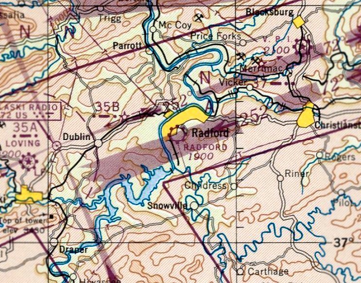
Radford Airport, as depicted on the April 1947 Winston-Salem Sectional Chart.
Radford Airport was evidently established at some point between 1946-47,
as it was not yet depicted on the October 1946 Winston-Salem Sectional Chart.
The earliest depiction which has been located of Radford Airport was on the April 1947 Winston-Salem Sectional Chart.
It depicted Radford as a commercial/municipal airport.
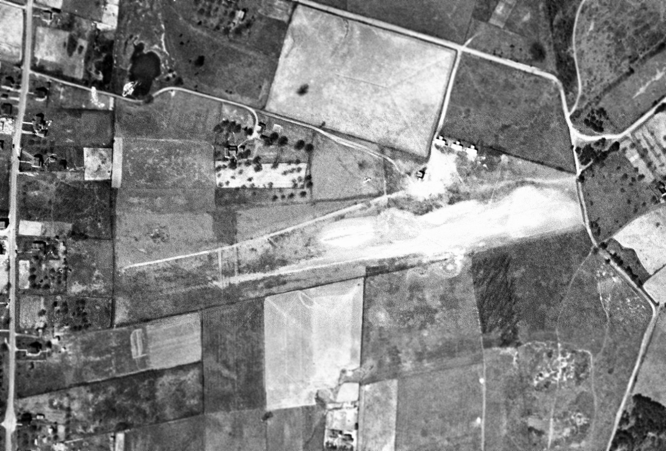
The only photo which has been located showing Radford Airport in operation was a 3/29/49 USGS aerial view.
It depicted Radford Airport as having a single unpaved northeast/southwest runway, with 3 T-hangars & 1 light single-engine aircraft on the north side.
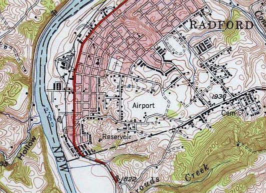
The 1950 USGS topo map depicted Radford Airport as a small open area in the southwest part of the town, generically labeled as “Airport”.
The last aeronautical chart depiction which has been located of Radford Airport was on the January 1952 Winston-Salem Sectional Chart.
It depicted Radford as having a mere 1,800' unpaved runway.
Radford Airport was evidently closed (for reasons unknown) at some point in 1952,
as it was no longer depicted on the July 1952 Winston-Salem Sectional Chart.
The 1965 USGS topo map still generically depicted Radford Airport as a small open area labeled as “Airport”.
A 1965 USGS aerial photo showed that houses had been built over the site of Radford Airport,
with Custis Street having been built over the runway alignment.
The 1966 USGS topo map no longer depicted Radford Airport.
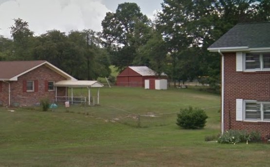
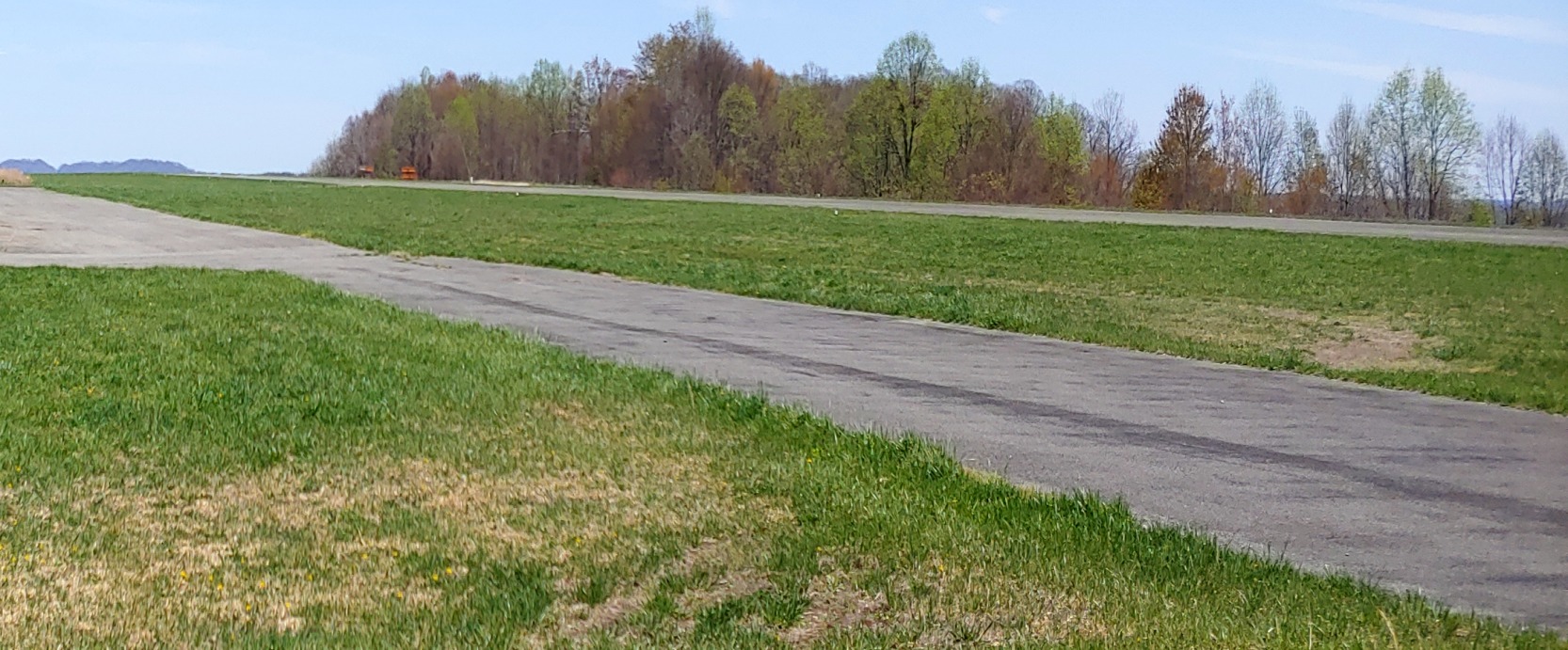
A July 2012 photo looking north at a shed on the northeast side of the Radford Airport site which may be a former T-hangar.
A 2017 aerial view appeared to show no trace remaining of Radford Airport.
However, a closer inspection by Tekang Wang revealed 1 former T-hangar may remain on the northeast side of the property, almost 7 decades after the airport's closure.
____________________________________________________
Bluefield Airport (original location), Bluefield, VA
37.248, -81.248 (Southwest of Washington, DC)
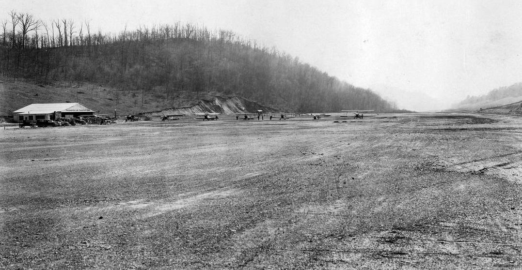
A 1929 photo of 8 biplanes & monoplanes in front of the hangar at Bluefield Municipal Airport (courtesy of Tom Hietzman).
The original airport for the town of Bluefield was established in 1928.
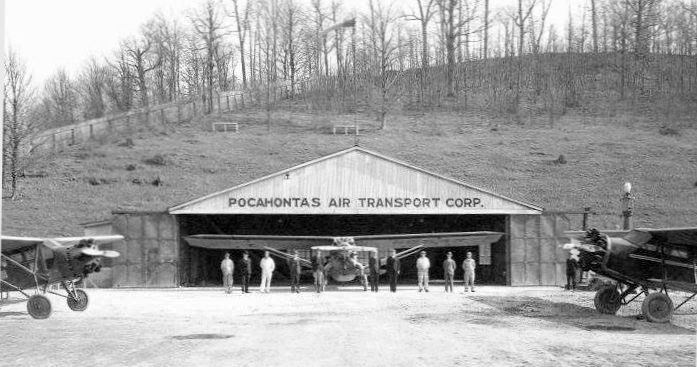
An undated (circa 1920s-30s) photo of the staff of Pocohontas Air Transport Corporation & 3 aircraft in front of their hangar at Bluefield Municipal Airport (courtesy of Rick Harshbarger).
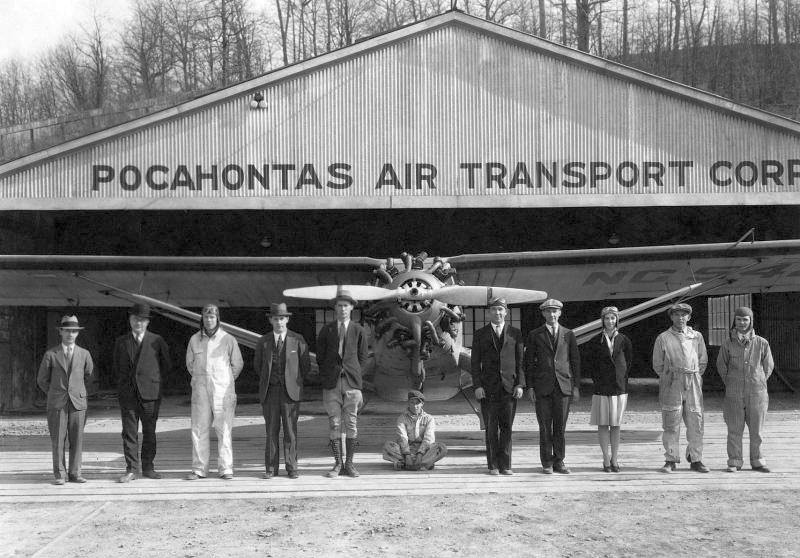
A closeup from the undated (circa 1920s-30s) photo of the staff of Pocohontas Air Transport Corporation
in front of an unidentified monoplane at Bluefield Municipal Airport (courtesy of Rick Harshbarger).
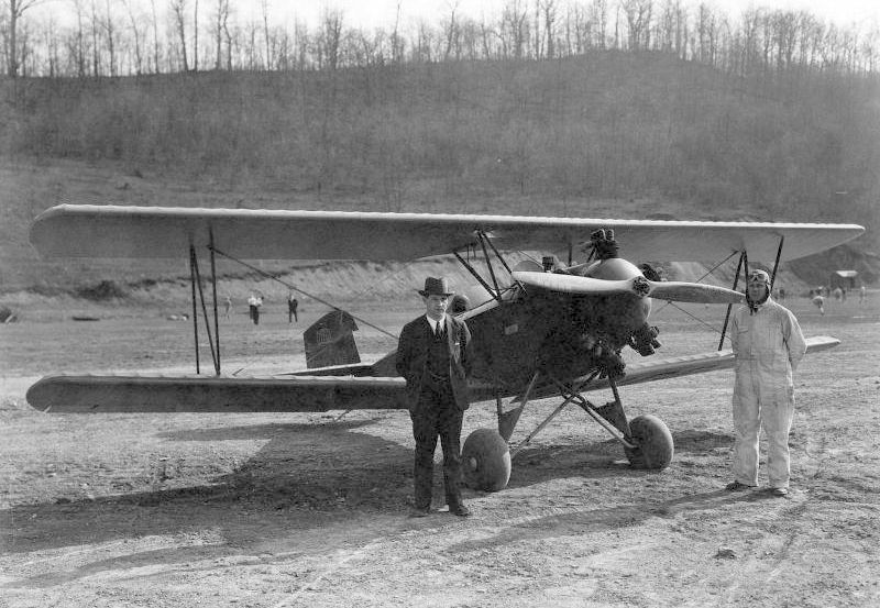
An undated (circa 1920s-30s) photo of 2 unidentified people & an unidentified biplane at Bluefield Municipal Airport (courtesy of Rick Harshbarger).
According to an article entitled “Port In Midst of Big Season; People Of Bluefield & Pocahontas Coal Field Becoming Air-Minded”
in the 7/29/31 Bluefield Daily Telegraph (courtesy of Rick Harshbarger),
“In spite of adverse economic conditions, the Bluefield Municipal Airport is in the midst of Its most successful season since it was established 3 years ago,
officials of the Pocahontas Air Transport Company announced yesterday.
Indicative of how people of Bluefield & the Pocahontas coalfield are becoming alr-mlnded
is the fact that during the last few weeks an average of 5 passengers have been carried each day on the line that links Bluefield & Charleston.
In addition to providing dally plane service between Bluefield & the capital of the state,
the local airport, when there is demand for it, operates a passenger line to White Sulphur Springs, where plane connections are made for Washington & New York City.
While many Bluefield businessmen are fast turning to the airplane as the most efficient method of transportation,
a good many of the passengers carried on the Bluefield-Charleston line are sightseers,
according to Laurence Tierney, general manager of the Pocahontas Air Transport Company.
Local folk who have made the Charleston-Bluefield trip by air declare that the rugged scenery that unfolds Itself from a plane
is unsurpassed anywhere in North America for magnificence & grandeur,
the mountains & valleys being at their most beautiful period at this time of the year.”
The article continued, “Aviation School Popular: The flying school that is taught in connection with the airport is In creasing in popularity
and there are enrolled at this time 11 students, one of them a woman.
Low tuition fees & instructors that are unusually competent have combined to attract to Bluefield aviation students from a wide area in southern WV & southwestern VA.
Bill Duff, chief pilot of the Pocahontas Air Transport Company, the instructor in charge of the flying school,
while Harvey Amos, Airport Manager, and Chester Crowell, Chief Mechanic, both of whom hold transport pilot's licenses, also assist with the instruction.
Since establishment of the school upwards of two score students have qualified for private licenses
and several have been granted transport & limited commercial licenses.”
The article continued, “Started more or less as an experiment & at a time when the airplane was a novelty to most of the citizenry,
the Bluefield Municipal Airport has steadily gained in prestige & usefulness until it has long since taken its place as one of the community's greatest assets.
A flying field that possesses many natural advantages, its proximity to the heart of the city & the total absence of any accidents
are a few of the many factors that have been contributed to the success of the local airport.
Improvements Made: Several months ago the Bluefield Airport was officially designated as the Bluefield Municipal Airport
by the state of VA & as a result of this action the VA State Highway Department has made extensive improvements to the field without any cost to the operating company.
Aviators declare that Bluefield now has one of the finest airports in VA
and that the lauding held, from the standpoint of smoothness & size, is unsurpassed in either of the Virginias.
The runway at the airport has been lengthened by the state until it is now almost a mile in length.
State forces have also widened the field, erected a large marker & made other innovations.
Another improvement that is expected to bo started by the state of VA before long is the paving of the road that leads from College Avenue to the airport.
When this is done, the scant 5 minutes that are now required to drive from the main part of Bluefield to the airport will be lessened by at least a minute.
Thousands of passengers have flown in planes owned by the Pocahontas Air Transport Company,
but during the 3 years that the local airport has been in existence there has not been a single accident.”
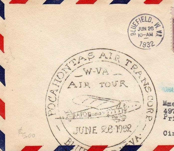
A 6/26/32 postmark commemorating the Pocohontas Air Transport Corporation WV Air Tour at Bluefield (courtesy of Rick Harshbarger).
The only aerial photo which has been located of Bluefield Airport was an August 1936 aerial view,
which depicted the field as having an unpaved northeast/southwest cleared area.
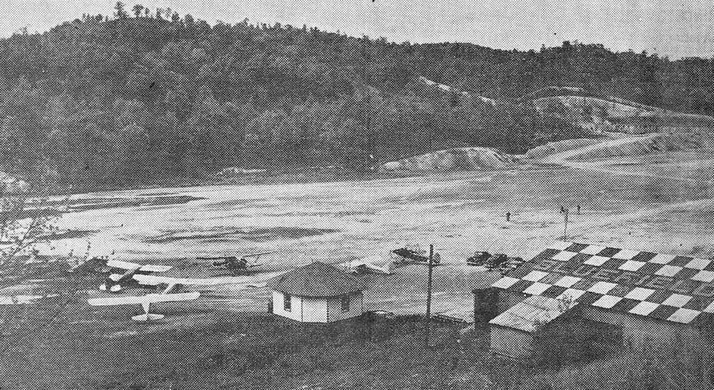
An undated photo from a 1939 article showing 7 light single-engine aircraft, a small building, and a checkerboard-roofed hangar at Bluefield Municipal Airport (courtesy of Rick Harshbarger).
The article said that 17 acres of the airport land, owned by Bluefield College,
would be turned over to the city for development as a recreational center under a plan under consideration by the City Board of Directors.
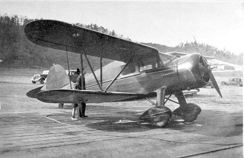
The last photo which has been located of Bluefield Airport was a circa 1941 or later photo by Charlie Bell's father of a Waco biplane (model undetermined) at Bluefield Municipal Airport.
Charlie recalled, “Since the field was dirt & gravel it could be a mess when it rained. The plane is parked on wooden slats to keep it out of the mud.
Those were the heydays of the coalfields & many coal companies & lumber companies had their own private company planes.
The road & structure off of the left wing is the Mitchell Field football stadium.
The stadium was built by the WPA in 1941”, helping to date the photo.
Bluefield Municipal Airport was evidently closed at some point between 1941-45,
as it was no longer listed among active airfields in the 1945 AAF Airfield Directory (courtesy of Scott Murdock).
Its closure was no doubt prompted by wartime restrictions on small general aviation airports.
Bluefield Municipal Airport was eventually replaced by the larger Mercer County Airport several miles to the northeast, which opened in 1954.
An 11/7/53 aerial view looking west (courtesy of Rick Harshbarger) showed no trace remaining of Bluefield Municipal Airport,
with the runway covered by the stadium parking lot.
Rick reported, “West Virginia & Virginia Tech are playing football at Mitchell Stadium.
Seventh-ranked Mountaineers won 12-7 in front of a standing-room-only crowd.”
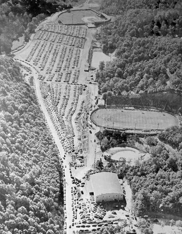
A 1955 aerial view showed the site of Bluefield Municipal Airport had been covered by Bowen Field (a baseball field) & its parking lot.
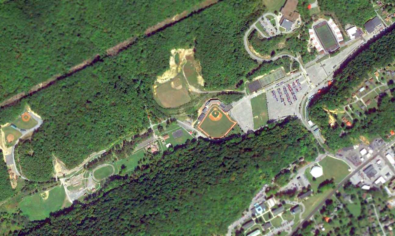
A 2015 aerial view showed no trace remaining of Bluefield Municipal Airport.
The site of Bluefield Municipal Airport is located at the present-day location of Bowen Field, west of Stadium Drive.
Thanks to Rick Harshbarger for pointing out this airfield.
____________________________________________________
36.58, -80.913 (West of Richmond, VA)
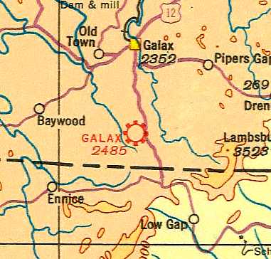
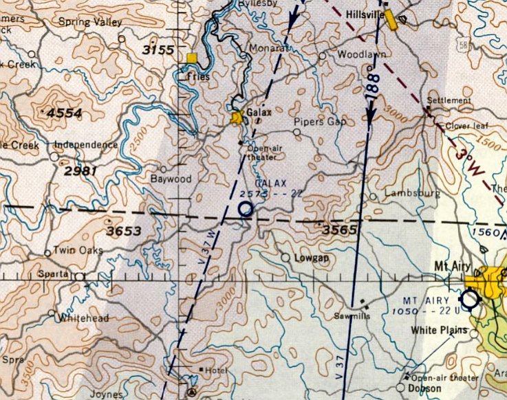
Galax Airport, as depicted on the 1935 Winston-Salem Sectional Chart.
The date of establishment of this small general aviation airport to the south of Galax has not been determined.
The earliest depiction which has been located of Galax Airport was on the 1935 Winston-Salem Sectional Chart,
which depicted Galax as a commercial/municipal airport.
The Airport Directory Company's 1937 Airport Directory (courtesy of Bob Rambo)
described Galax as a municipal airport consisting of a 150 acres, with 3 sod runways,
the longest being the 2,500' northeast/southwest & northwest/southeast strips.
A hangar was said to be painted with “Galax VA Airport”.
According to the book "Virginia Airports" by Vera Rollo & Norman Crabill (published by the VAHS),
“License applied for by J.A. Eads 1/9/42 for site of the former Galax Airport.
Granted 2/20/42 & transferred twice.”

The earliest photo which has been located of Galax Airport
was a circa 1943 aerial view looking north from the 1945 AAF Airfield Directory (courtesy of Scott Murdock).
It depicted Galax as having an unpaved landing area.
The 1945 AAF Airfield Directory (courtesy of Scott Murdock) described Galax Airport
as a 71-acre rectangular property having 2 sod runways, measuring 1,800' NNW/SSE & 1,500' north/south.
The field was said to have a single 80' x 60' wood & concrete block hangar, and to be owned & operated by private interests.
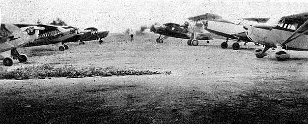
A circa 1940s newspaper photograph was captioned “Galax has adequate airport facilities:
That Galax is airminded is evidenced by these individually-owned planes lined up on the airfield 5 miles south of the city.”
The last aeronautical chart depiction which has been located of Galax Airport was on the April 1961 Winston-Salem Sectional Chart.
It depicted Galax as having a 2,200' unpaved runway.
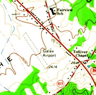
The last depiction which has been located of Galax Airport was on the 1965 USGS topo map.
It depicted Galax as having a single unpaved northwest/southeast runway, with a single small building on the east side.
Galax Airport was evidently closed at some point between 1961-65,
as it was no longer depicted on the April 1965 Winston-Salem Sectional Chart.
According to the book "Virginia Airports" by Vera Rollo & Norman Crabill (published by the VAHS),
“11/20/65 license canceled since airport was inoperative for several years & put to other uses.”
The 1978 USGS topo map no longer depicted Galax Airport.
The 1995 USGS aerial view did not show any remaining trace of Galax Airport.
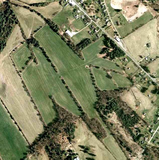
A 1/31/07 aerial view did not show any remaining trace of Galax Airport,
other than the northwest/southeast clearing which corresponds to the runway alignment.
The site of Galax Airport is located west of the intersection of Route 89 & Fairview Road.
____________________________________________________
Covington Clifton Forge Airport, Covington, VA
37.796, -79.88 (West of Richmond, VA)
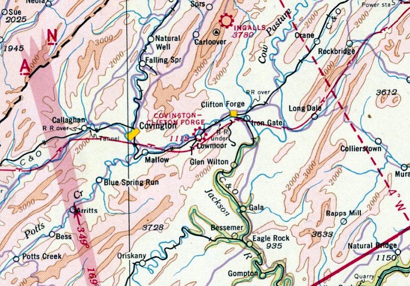
Clifton Forge Airport, as depicted on the January 1941 Winston-Salem Sectional Chart.
This small general aviation airport may have been established at some point between 1938-41,
as it was not yet listed among active airfields in The Airport Directory Company's 1937 Airport Directory (courtesy of Bob Rambo)
or depicted on the December 1938 Winston-Salem Sectional Chart.
The earliest depiction which has been located of Clifton Forge Airport was on the January 1941 Winston-Salem Sectional Chart.
It depicted Clifton Forge Airport as a commercial/municipal airport.
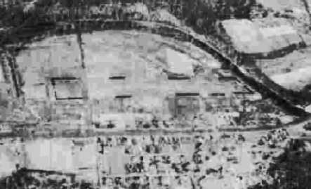
The earliest photo which has been located of Clifton Forge Airport was a circa 1943 aerial view looking north from the 1945 AAF Airfield Directory (courtesy of Scott Murdock).
According to the book "Virginia Airports" by Vera Rollo & Norman Crabill (published by the VAHS),
“Clifton Forge Airport... license granted 6/18/45 for private-commercial airport.”
The 1945 AAF Airfield Directory (courtesy of Scott Murdock) described Covington Clifton Forge Airport
as a 17-acre rectangular property having a single 2,400' NNE/SSW sod runway.
The field was said to have 2 wooden hangars, the largest measuring 100' x 26', and to be owned & operated by private interests.
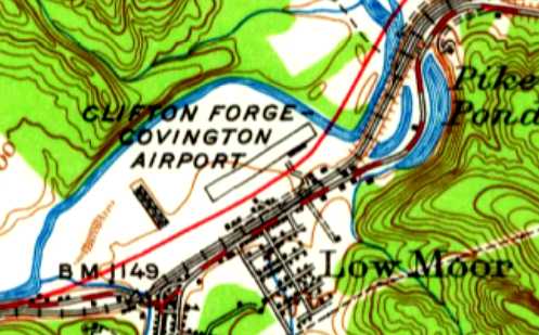
The earliest topo map depiction which has been located of Clifton Forge Covington Airport was on the 1945 USGS topo map.
It depicted the field as having a single northeast/southwest runway, with a single building along the southeast side.
The last aeronautical chart depiction which has been located of Clifton Forge Airport was on the June 1958 Winston-Salem Sectional Chart.
According to the book "Virginia Airports" by Vera Rollo & Norman Crabill (published by the VAHS), “Clifton Forge Airport... license canceled 11/10/58.”
Clifton Forge Airport was no longer depicted on the January 1959 Winston-Salem Sectional Chart.
The 1964 USGS topo map showed the newly-built Interstate 64 passing right through the center of the Clifton Forge Airport property.
The 1995 USGS aerial view did not show any remaining trace of Clifton Forge Airport.

A 1/31/07 aerial view did not show any remaining trace of Clifton Forge Airport.
The site of Clifton Forge Airport is located northeast of the intersection of Interstate 64 & Selma Low Moor Road.
____________________________________________________
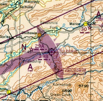
Chilhowie Intermediate Field / CAA Site 29B / Chilhowie Airport, Chilhowie, VA
36.75, -81.64 (West of Richmond, VA)
The 1935 USGS topo map labeled Chilhowie as “Landing Field”.
Chilhowie Intermediate Field was not yet depicted on the 1935 Winston-Salem Sectional Chart.
The earliest depiction which has been located of Chilhowie Intermediate Field was on the 1935 USGS topo map,
which depicted a property outline labeled simply as “Landing Field”.
Chilhowie was established as one of the Department of Commerce's network of Intermediate Fields,
which were for emergency use of airliners flying airways between major cities.
The Airport Directory Company's 1937 Airport Directory (courtesy of Bob Rambo)
described Chilhowie as a Department of Commerce Intermediate Field, Site 28B along the Nashville-Washington airway.
The field was said to have a single 3,300' northeast/southwest runway,
and to be illuminated, but not having any services.
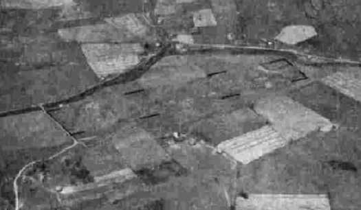
The earliest photo which has been located of Chilhowie Intermediate Field
was a circa 1943 aerial view looking north from the 1945 AAF Airfield Directory (courtesy of Scott Murdock).
It depicted Chilhowie as having a single unpaved runway.
An undated aerial view depicted Chilhowie as having a single unpaved runway.
The 1945 AAF Airfield Directory (courtesy of Scott Murdock) described Chilhowie Intermediate Field
as a 46-acre rectangular property having a single 3,400' northeast/southwest sod runway.
The field was said to have a single 50' x 36' wood & metal hangar,
to be owned by private interests, and operated by the Civil Aeronautics Administration.
The only aeronautical chart depiction which has been located of Chilhowie Airport was on the March 1945 Winston-Salem Sectional Chart.
It depicted Chilhowie as also having Commerce Department Airway Beacon #29B.
Chilhowie Airport was evidently closed (for reasons unknown) at some point between 1945-60,
as the rectangular outline of the Chilhowie runway was still depicted on the 1960 & 1968 USGS topo maps,
but the airport was no longer labeled.
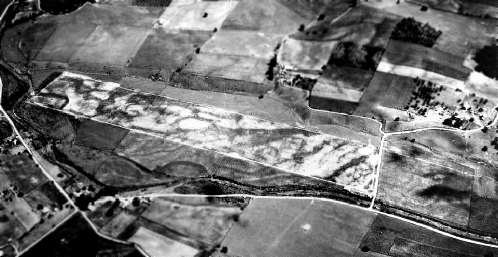
A 4/30/99 USGS aerial view looking northeast still showed a distinctive runway outline at the site of Chilhowie Airport.
Amazingly, 60 years after Chilhowie Airport was closed, a 1/31/07 aerial view looking northeast still showed a distinctive runway outline.
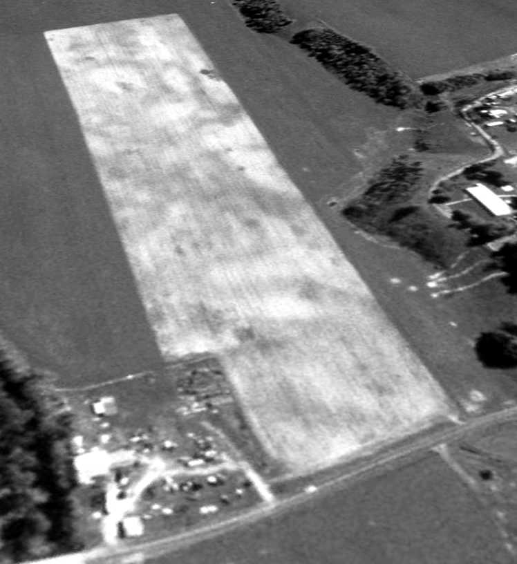
Jon Rained reported in 2013, “The airport is today known as 'Catron Field', and is privately owned by Curtis Pennington.
The field is still active, and a couple of new hangars have even been constructed in the last few years.
The field occasionally hosts a fly-in and cookout that's quite popular locally, especially with ultralight pilots.”
The site of Chilhowie Airport is located east of the intersection of Whitetop Road & Old Airport Road, appropriately enough.
____________________________________________________
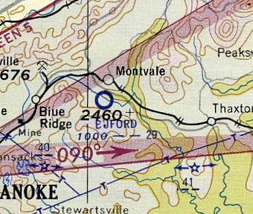
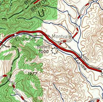
Buford Airport / Buford's Airport, Montvale, VA
37.384, -79.734 (West of Richmond, VA)
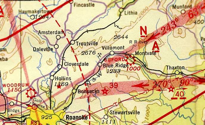
Buford Airport, as depicted on the August 1942 Winston-Salem Sectional Chart (courtesy of Chris Kennedy).
This small general aviation airport was evidently established at some point between 1935-42,
as it was not yet depicted on the March 1935 Winston-Salem Sectional Chart (according to Chris Kennedy).
The earliest depiction which has been located of Buford Airport
was on the August 1942 Winston-Salem Sectional Chart (courtesy of Chris Kennedy).
It depicted Buford as a commercial/municipal airport.

The earliest photo which has been located of Buford's Airport was a circa 1942-45 aerial view looking north
from the 1945 AAF Airfield Directory (courtesy of Scott Murdock).
It depicted “Buford's Airport” as having a single grass runway.
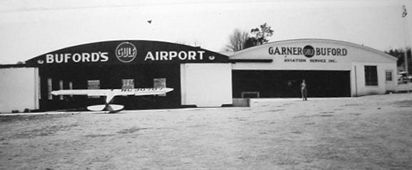
An undated (circa early 1940s?) photo depicting a Piper Cub in front of the 2 hangars of Buford's Airport (courtesy of Dillard Prather).
According to David Brooks, Buford's may have served as a Navy Outlying Field during WW2.
According to George Hill, “The Montvale airfield... The field was used as a kind of auxiliary for Woodrum Field training operations,
with Stearman type planes using the Montvale field, with some maintenance done there also.
There was at least one notable fatal crash in the vicinity during the war years.”
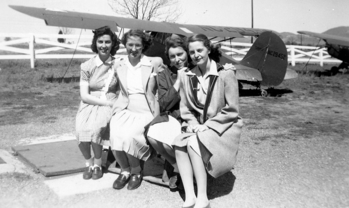
A circa 1943 photo of Valleda Pittard Chandler & several friends in front of aircraft at Buford's Airport (courtesy of Gray Chandler).
Vicky Fuller reported, “My grandmother, Nancy Morehead Tayloe, is the woman in the dark coat, 3rd from the left.”
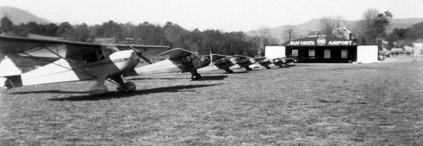
A circa 1943 photo of a line of Cessnas & Pipers in front of the Buford's Airport hangar (courtesy of Gray Chandler).
Note that only 1 hangar was depicted, with the 2nd hangar visible in the earlier photo evidently having been removed.
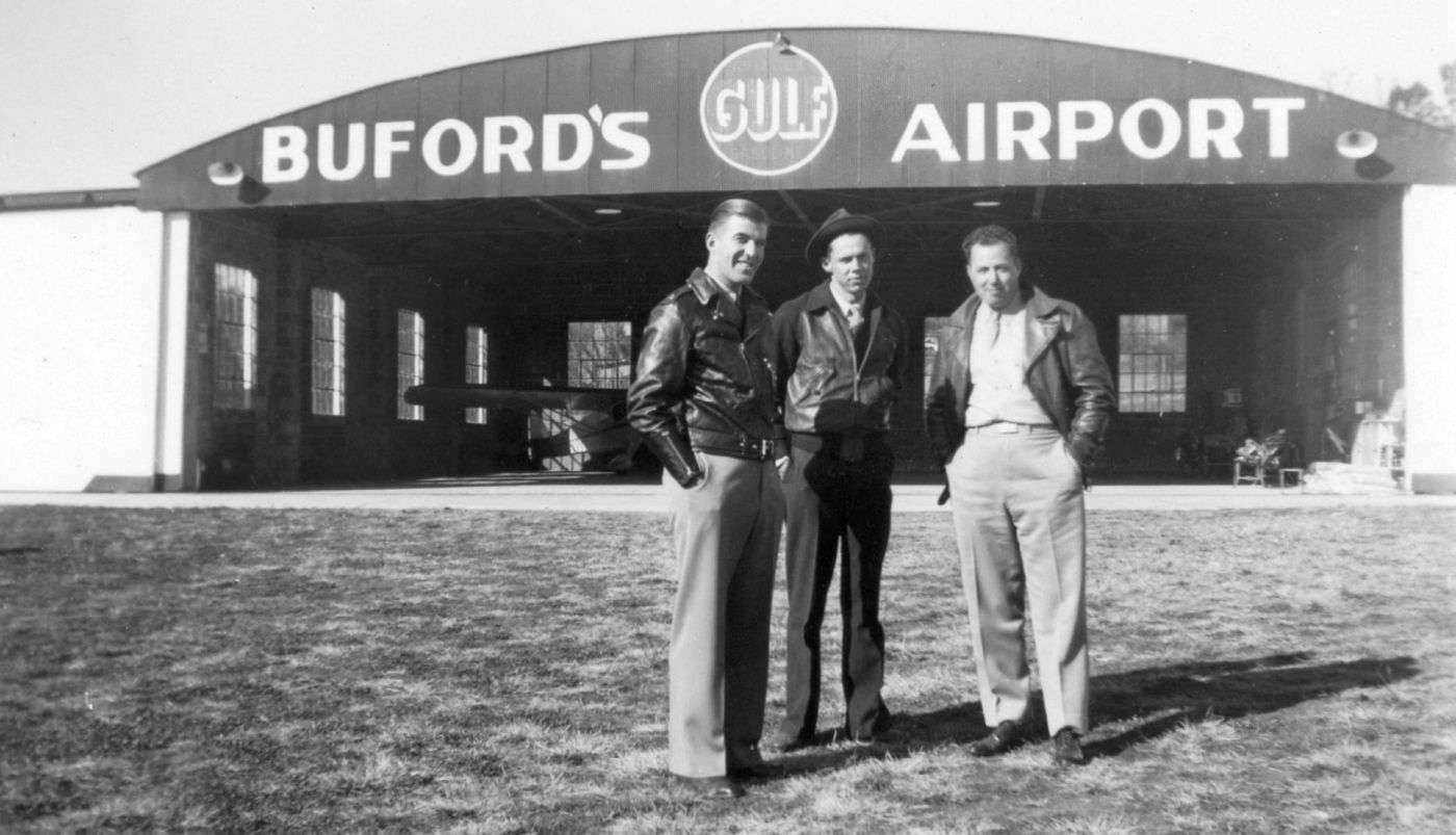
A circa 1943 photo of 3 unidentified men in front of the Buford's Airport hangar (courtesy of Gray Chandler).
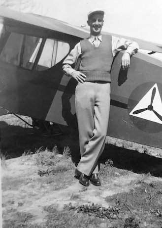
A circa 1943 photo of an unidentified man in front of a Civil Air Patrol plane at Buford's Airport (courtesy of Vicky Fuller).
The 1945 AAF Airfield Directory (courtesy of Scott Murdock) described “Buford's Airport”
as a 40-acre rectangular property having a single 3,250' northwest/southeast runway.
The field was said to have 2 cinderblock & steel 60' square hangars,
and to be owned & operated by private interests.

The earliest topo map depiction which has been located of Buford's Airport was on the 1950 USGS topo map.
It depicted “Buford's Airport” as an unpaved field oriented northwest/southeast, with a single building on the north corner.
The last aeronautical chart depiction which has been located of Buford Airport
was on the July 1954 Winston-Salem Sectional Chart (courtesy of Chris Kennedy).
It depicted Buford as having a 2,900' unpaved runway.
Buford Airport, as depicted on the 1957 USGS topo map.
The last listing which has been located of Buford Airport was in the 1957-58 Aviation Week Airport Directory (courtesy of Chris Kennedy).
It described Buford Airport as “limited” use, with a 2,900' unpaved northwest/southeast runway, managed by J.L. Buford.
However the field was described as “Closed to all traffic except in emergency.”
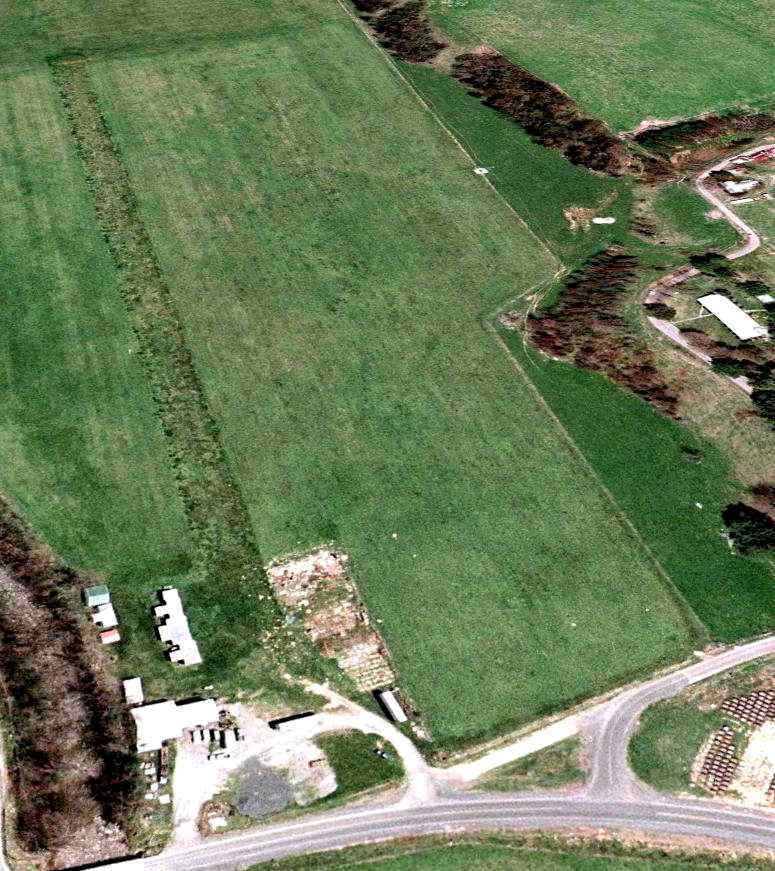
The last photo which has been located of Buford Airport was a 1960 aerial view,
which depicted the field as having a single grass northwest/southeast runway,
with a single hangar at the northwest corner.
There were no aircraft visible on the field.
“Buford's Airport” was depicted in an unchanged fashion on the 1969 USGS topo map.
Buford Airport evidently closed (for reasons unknown) at some point between 1957-70,
as the 1970 USGS topo map depicted a cluster of 4 oil storage tanks having been built on the site.
According to George Hill, “The Montvale airfield... I learned of the hangar's history in 1987
from an older mechanic when I was selling wiping products to the company there at the time.
The cinder block building at the NW corner of the picture is an original WWII-era hangar.
That hangar has been used as a maintenance shop for various trucking companies for decades.”
In the 1996 USGS aerial photo, a set of oil storage tanks were located on the property,
and there were no traces of the former airport.
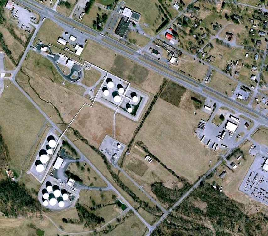
A February 1, 2007 aerial view showed the site of Buford's Airport covered by an oil storage facility.
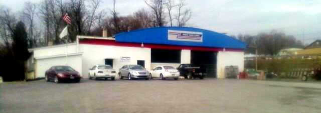
A 2011 photo by George Hill of a former hangar from Buford's Airport.
According to George, “The ramp area extended straight East to where the other hangar once sat.
I have a picture down the road that sits over the former paved runway. The owner lived in the old inn that sits directly behind the remaining hangar.
Across US 460 are the remains of the former gas station & motel complex that a mechanic told me people would fly in & stay at that motel, then fly on (in the 1950s).”
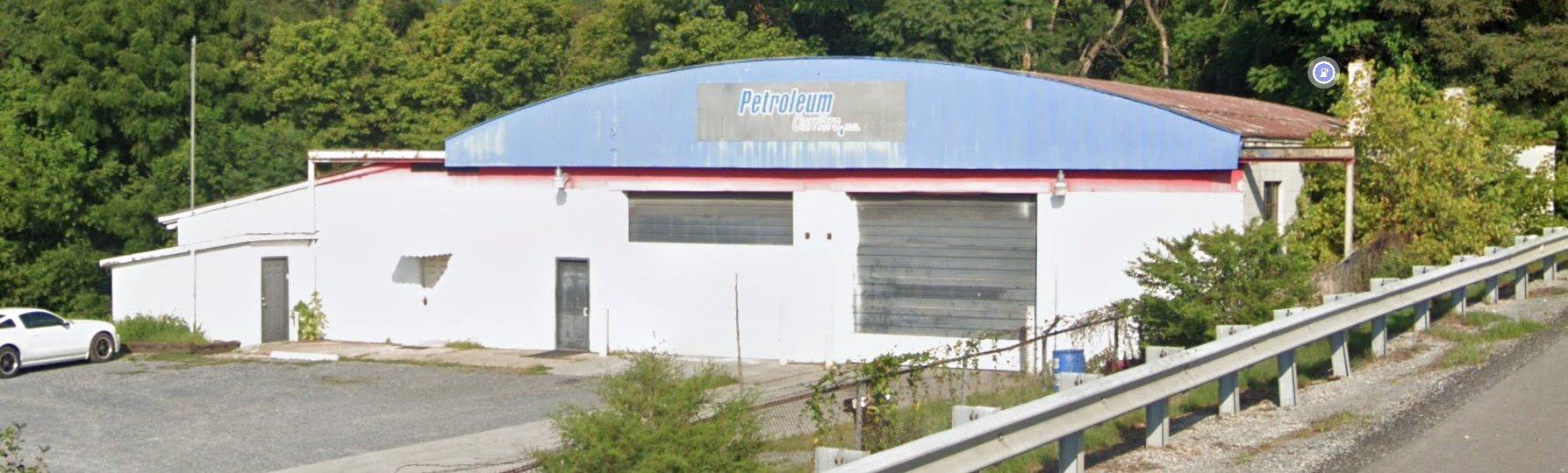
A 2022 photo looking west at the former Buford's Airport hangar.
The site of Buford's Airport is located southeast of the intersection of Route 460 & Oil Terminal Road.
Thanks to David Brooks for pointing out this airfield.
____________________________________________________
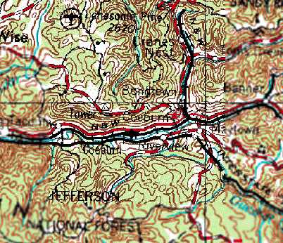
Coeburn Airport (5VA7), Coeburn, VA
36.935, -82.5 (Southwest of Richmond, VA)
Coeburn Airport, as depicted on the 1966 USGS topo map.
Photo of the airport while open has not been located.
Coeburn Airport was not depicted on Winston-Salem Sectional Charts from 1960/65/68.
From 1964-71, this location was reportedly used as the Coeburn Airport Dragstrip, owned by J.B. Tiller.
The earliest depiction which has been located of Coeburn Airport was on the 1966 USGS topo map.
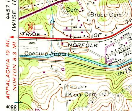
The 1969 USGS topo map depicted Coeburn Airport as having a single unpaved east/west unpaved runway,
with one small building along the northeast side.
A 1969 aerial photo depicted Coeburn Airport as having a single east/west unpaved runway,
with one small building along the northeast side.
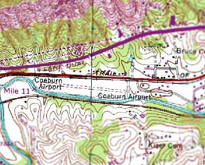
The 1991 USGS topo map depicted Coeburn Airport as having a single unpaved east/west unpaved runway.
Coeburn Airport was evidently closed (for reasons unknown) by 1994,
as it was no longer listed among active airfields in a 1994 airport directory (courtesy of Gwen Shafer).
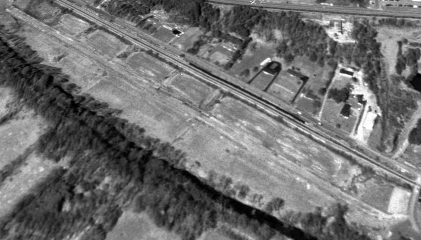
A 1998 USGS aerial view looking northwest showed Coeburn to have a single east/west runway,
but it did not show any sign of recent aviation usage.
A 2013 aerial view looking northwest showed that Coeburn Airport appeared to have a paved runway, which remained intact.
A single building sat just southeast of the runway.
A 2018 photo looking south showed the former Coeburn Airport paved paved runway (on the far side of the railroad tracks) remained intact.
As of 2023, road maps labeled the Coeburn Airport site as Twin River Raceway.
The site of Coeburn Airport is located southwest of the intersection of Route 813 & Route 658.
Thanks to Steve Matda for pointing out this airfield.
____________________________________________________
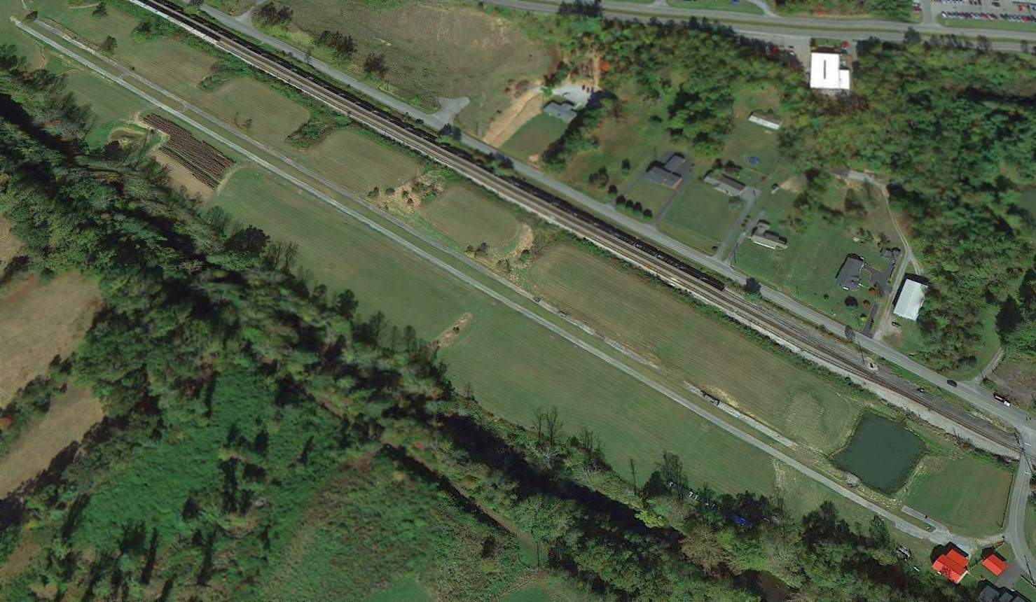
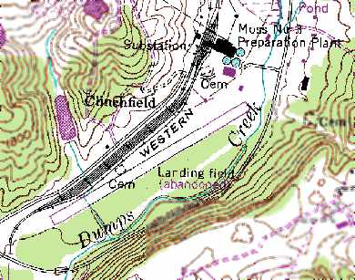
Clinchfield Airport, Clinchfield, VA
36.952, -82.186 (Southwest of Richmond, VA)
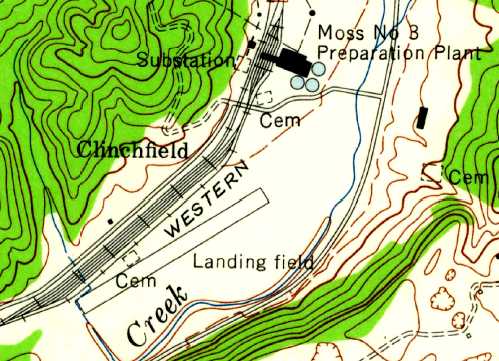
Clinchfield Airport, as depicted on the 1958 USGS topo map.
Photo of the airport while open has not been located.
No airfield was depicted at this location on the 1941 USGS topo map.
According to Steve Matda, the Clinchfield Airport “was constructed in the 1950s time frame
by Clinchfield Coal Company on the site of its Moss #3 Preparation Plant,
which at the time was the world's largest coal preparation facility.
Also nearby was Clinchfield's Central Shop, Central Laboratory, Company Store,
and Moss #2 Mine as well as the Appalachian Power Company's Clinch River Generating Plant.
It was paved.”
According to Steve Matda, “I asked my dad (Frank Matda) about it (he worked for Clinchfield for 38 years).
He said that small twin-engine planes used it regularly.”
Frank Matda recalled, “It was built when AEP built the Clinch River Powerplant for primarily for their own use shortly before 1956.
It was built on Clinchfield Coal Company property, located just below the Moss #3 Preparation Plant.
The lower end runway stopped just short of the concrete bridge that crossed over the railroad & creek.
I thought that I was going to hit a plane that was taking off as it just cleared the bridge, on my way home one day.
I believe Clinchfield also used the strip occasionally."
The 1958 USGS topo map depicted Clinchfield as having a single 2,000' northeast/southwest paved runway, labeled simply as “Landing Field”.
Clinchfield Airport was not yet depicted on the June 1958 Winston-Salem Sectional Chart.
The earliest aeronautical chart depiction which has been located of Clinchfield Airport was on the January 1959 Winston-Salem Sectional Chart.
It depicted Clinchfield as a private airfield having a 2,000' paved runway.
According to Frank Matda, the Clinchfield Airport was abandoned sometime around 1962.
The 1971 USGS topo map showed that the northeast end of Clinchfield's runway had been lengthened at some point between 1958-71,
to a total length of 3,300'.
The 1974 USGS topo map depicted the airfield in an unchanged fashion.
Clinchfield Airfield was evidently abandoned at some point between 1974-78,
as it was labeled “Landing Field (Abandoned)” on the 1978 USGS topo map.
Frank Matda recalled, “There were rumors that the FAA stopped them from using it.
After it was abandoned, Clinchfield used it as a storage facility.
I have spent many many man-hours driving up & down its entire length looking for material & supplies."
The 1989 USGS topo map labeled the field as “Landing field (abandoned)”.
It depicted Clinchfield Airport as having a single 3,100' northeast/southwest paved runway,
with the buildings of the “Moss #3 Preparation Plant” on the northeast side of the field.
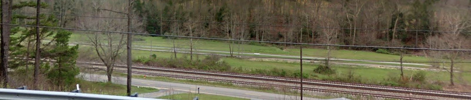
In the 1998 USGS aerial photo, the southwestern half of the runway pavement remained intact,
but the northeastern half of the strip had been covered by coal.
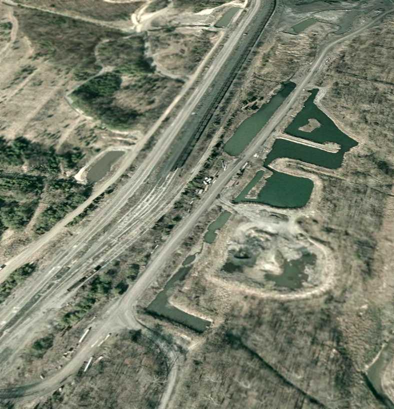
A 2/1/07 aerial view looking northeast showed the field remaining in the same condition as depicted in 1998,
with the southwestern half of the runway pavement still remaining intact.
Steve Matda reported of the Clinchfield Airport in 2007, “It hasn't been used in at least 30 years.
The north end is now covered by a coal stockpile.”
According to Frank Matda, “At the present time I don't know if it is still used or reclaimed."
The site of the Clinchfield Airport is located northeast of the intersection of Route 615 & Route 616.
Thanks to Steve Matda for pointing out this airfield.
____________________________________________________
(Original) Lee County Airport / Pennington Gap Airport, Pennington Gap, VA
36.745, -83.038 (Southwest of Richmond, VA)
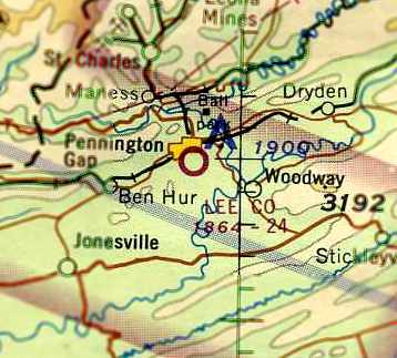
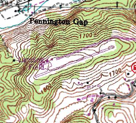
The original Lee County Airport, as depicted on the March 1966 Winston-Salem Sectional Chart (courtesy of Chris Kennedy).
The original Lee County Airport was located just southwest of Pennington Gap.
It was evidently established at some point between 1964-66,
as it was not yet depicted on the 1949 USGS topo map nor on the April 1964 Winston-Salem Sectional Chart (according to Chris Kennedy).
The earliest depiction which has been located of the Lee County Airport
was on the March 1966 Winston-Salem Sectional Chart (courtesy of Chris Kennedy).
It depicted Lee County as having a 2,400' unpaved runway.
The Lee County Airport was evidently improved with a paved runway at some point within the next year,
as that is how it was described in the 1967 AOPA Airport Directory (according to Chris Kennedy).
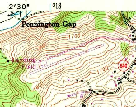
The 1969 USGS topo map depicted the original Lee County Airport as having a single northeast/southwest paved runway,
with a small parking ramp with several small buildings on the northwest side.
It was labeled simply as “Landing Field”.
David Hensley recalled, “The old Pennington Gap airport... I did one of my solo cross-country flights there back in the late 1970s / early 1980s.
I had a little trouble finding it; I had to get my location using dual VORs & then followed the railroad tracks.
I was used to flying out of a 5,000' runway & had never been into a runway that short (2,200’) before.”
Lee County was still described as a public-use airfield in the 1986 Flight Guide (according to Chris Kennedy).
The 1991 USGS topo map depicted the original Lee County Airport as having a single northeast/southwest paved runway,
with a small parking ramp with several small buildings on the northwest side.
It was labeled simply as “Landing Field”.

A 1994 airport directory (courtesy of Gwen Shafer) depicted the original Lee County Airport as having a single 2,262' paved Runway 7/25
with a small parking ramp with several small buildings on the northwest side.
The earliest photo which has been located of the original Lee County Airport was the 1995 USGS aerial photo.
It depicted the airfield as having a single paved Runway 7/25,
with a small parking ramp with several small buildings on the northwest side.
No aircraft were visible on the field.
A replacement Lee County Airport (with a longer runway)
was constructed several miles to the southwest in Jonesville, and opened in 2002.
The original airport did not immediately close, though,
and evidently stayed open for some period of time as a private airfield.
The December 2003 Cincinnati Sectional Sectional Chart (courtesy of Chris Kennedy)
depicted the field as “Pennington Gap”, a private airfield.
It was described as having a single 2,200' east/west paved runway.
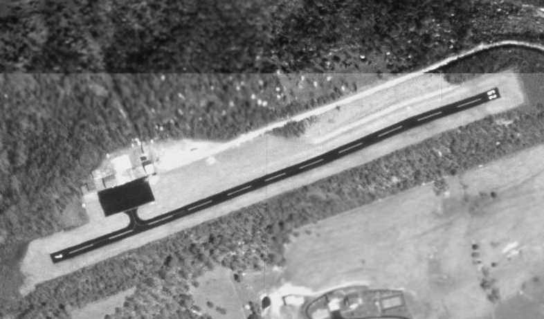
The Pennington Gap Airport evidently closed at some point between 2003-2005,
as a September 22, 2005 aerial photo showed the runway as being marked with 3 closed-runway “X” symbols.
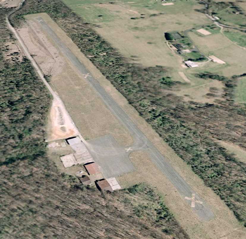
A February 1, 2007 aerial view looking east at Pennington Gap showed the runway as being marked with 3 closed-runway “X” symbols.
However, the field was still completely intact, with the runway, ramp, and hangars all remaining at the site.
The original Lee County Airport is located at the western terminus of Route 1122.
Thanks to Kyle Rodgers for pointing out this airfield.
____________________________________________________
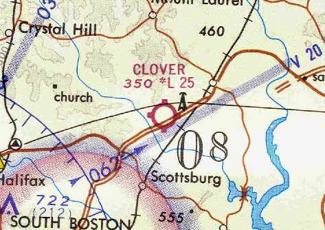
36.804, -78.772 (Southwest of Richmond, VA)
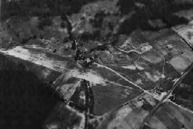
A 1936 aerial view looking northeast at the single runway of Clover Airport.
The Clover Airport was established in 1936, according to the book "Virginia Airports" by Vera Rollo & Norman Crabill (published by the VAHS).
It was also reportedly known as “W.W. Edmonson's Airport”, and served as a “private-commercial field”.
According to Shirley Sadler Bowen, “I am the great-neice of J.B. & Woodrow Edmondson & my father is Frank Sadler.
We have an old article that states that this airport was the 1st licensed airport in the state of Virginia.
My uncle was Woodrow Edmondson & J. B. Edmondson. They owned the Clover Airport back in 1936.
A plane named 'Little Butch' was flown there a long time ago & is now in the Smithsonian Museum in Washington, DC.”
The earliest depiction of Clover Airport which has been located was a 1936 aerial view,
which depicted the field as having a single unpaved northwest/southeast runway.
Clover Airport was not yet depicted on the June 1937 Winston-Salem Sectional Chart.
The Airport Directory Company's 1937 Airport Directory (courtesy of Bob Rambo)
listed a “Halifax” private airfield, 3 miles west of Clover, bordered by U. S. Highway 360 on the south.
The field was said to have a single 1,800' sod north-northwest/south-southeast runway.
The field was said to have a hangar, and to offer service during the daytime.
A November 1938 aerial photo in the book "Virginia Airports" (published by the VAHS)
depicted Clover Airport as having 2 sod runways: 2,020' north/south & 1,175' northwest/southeast.
The field was said to be owned by J.B. & S.S. Edmonson, and the lessee & manager was listed as L.R Petus.
The earliest aeronautical chart depiction which has been located of Clover Airport
was on the December 19378 Winston-Salem Sectional Chart.
The April 1944 US Army/Navy Directory of Airfields (courtesy of Ken Mercer) described the Clover Airport as being located 3 miles southwest of Clover,
and listed the field as having a 2,000' unpaved runway.
A 1951 aerial photo depicted Clover as having 2 unpaved runways, with a T-hangar & another small building at the southeast corner.
Nothing was depicted at the site of the Clover Airport on the 1954 USGS topo map.
The July 1961 Winston-Salem Sectional (courtesy of Harold Schaffer) depicted Clover as a public-use airport with a single 2,500' unlighted turf runway.
The field was said to offer fuel & major repairs.
The 1962 AOPA Airport Directory described the Clover Airport as having 2 turf runways: 2,500' Runway 13/31 & 1,700' Runway 4/22.
The operator was listed as Frank Sadler (the nephew of Clover Airport founder Woodrow Edmondson).
According to Shirley Sadler Bowen, “The reason it was unable to go on as an official airport was that between 1962-65
Highway 360 was made a dual lane highway & the powers-at-be declared that since it had been shortened
the airport runway could not officially be an airport for taking off & landings.”
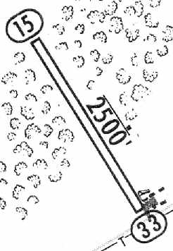
The 1965 Jeppesen Airway Manual (courtesy of Chris Kennedy) depicted Clover Airport as having a single 2,500' unpaved Runway 15/33.
A single small building was depicted on the east side of the runway, and a cluster of small buildings was depicted on the southeast side as well.
The manager was listed as Frank Sadler.
A 1967 aerial photo depicted Clover Airport as having 2 unpaved runways, with 3 T-hangars & 2 other small buildings at the southeast corner.
Harold Schaffer recalled of the Clover Airport, “I do remember during the late 1960s during my travels up U. S. 360 that the field was open & operating.”
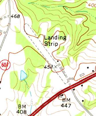
The 1968 USGS topo map still depicted a single northwest/southeast unpaved runway at Clover, labeled simply as “Landing Strip”,
along with a single small building on the east side of the runway.
According to the book "Virginia Airports" (published by the VAHS), Clover Airport operated as a “private-commercial field” until 1968.
However, Clover was still depicted as an active airfield on the April 1969 Washington Sectional Chart (courtesy of Chris Kennedy).
It depicted Clover as a public-use airport having a 2,500' unpaved runway.
Clover Airport evidently closed at some point between 1969-70,
as it was no longer depicted at all on the February 1970 Cincinnati Sectional Chart (according to Chris Kennedy).
In 1970 a license was applied for to operate Clover as a private field (according to the book "Virginia Airports"),
but this license was canceled in 1972.
It was “used for aircraft storage” in 1974, but reported as not active in 1975.
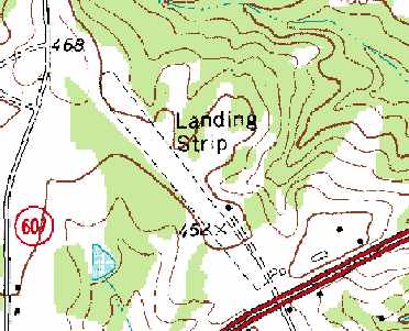
The 1989 USGS topo map still depicted a single northwest/southeast unpaved runway at Clover, labeled simply as “Landing Strip”,
along with a single small building on the east side of the runway.
Harold Schaffer reported in 2005, “I came by the old site yesterday on U.S. 360.
The place is, of course, all grown up & the trees down the old turf runway are very tall now.
The old pole with the skeleton of the windsock is still in place if one looks very carefully for it.
The old hangar building is still there also.”
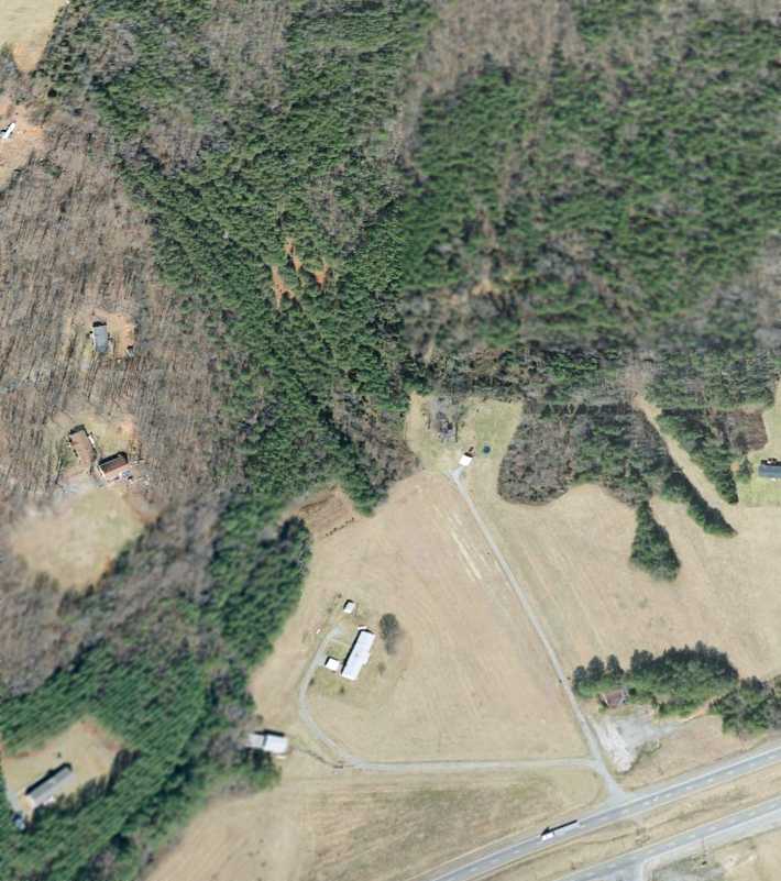
A 2007 aerial view looking north showed the outline of the northwest/southeast runway at Clover was still recognizable,
even though the majority of it had been overgrown.
What appeared to be the remaining hangar is on the east side of the runway.
Shirley Sadler Bowen reported in 2013, “There is a group of pilots & enthusiasts who are working on a possible small renovation of what’s left of the airport
along with some type of museum being placed there.”
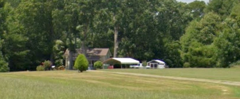
A 2022 photo looking northwest at the former hangar on the east side of the Clover Airport site.
The site of Clover Airport is located northwest of the intersection of Route 360 & Piney Creek Road.
Thanks to Harold Schaffer for pointing out this airfield.
____________________________________________________
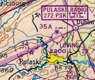
Pulaski Intermediate Field / Loving Field (PSK), Pulaski, VA
37.087, -80.779 (Southwest of Richmond, VA)
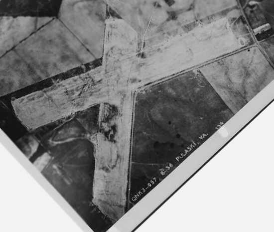
An August 1936 aerial view of Loving Field.
Pulaski Intermediate Field was established as the Commerce Department's network
established for the emergency use of commercial aircraft flying between major cities.
Pulaski Intermediate Field may have been established at some point between 1930-31,
as it was not yet listed in the 1930 Commerce Department Airway Bulletin (according to Mike Denja).
The earliest reference which has been located of Pulaski Field was in the Commerce Department's 1931 Airway Bulletin (courtesy of Mike Denja).
It described Pulaski as Site 33B along the Nashville-Washington Airway.
It described Pulaski as a sod field having 2 runways in a cross shape: 2,750' northeast/southwest & 2,300' north/south.
Pulaski Intermediate Field was not yet depicted on the 1935 Winston-Salem Airway Chart.
The earliest depiction which has been located of Pulaski Intermediate Field was an August 1936 aerial photo.
It depicted Pulaski Intermediate Field as having 2 grass runways, but did not appear to depict any buildings at the field.
The Airport Directory Company's 1937 Airport Directory (courtesy of Bob Rambo)
described Pulaski as the Commerce Department's Intermediate Field #33A, along the Nashville-Washington Airway.
It described Pulaski as consisting of 2 runways in a cross shape: 2,750' east/west & 2,300' north/south.
It was still described as the Department of Commerce's Intermediate Field #33A
in The Airport Directory Company's 1941 Airport Directory (according to Chris Kennedy).
At some point within the next year, the field's designation was evidently slightly changed, to Intermediate Field 33B,
as that is how it was depicted on the August 1942 Winston-Salem Sectional Chart (courtesy of Chris Kennedy).
Within the next 2 years the field's designation was changed once again, to Intermediate Field 35A,
as that is how it was depicted on the April 1944 Winston-Salem Sectional Chart (courtesy of Chris Kennedy).
The 1944 US Army/Navy Directory of Airfields (courtesy of Ken Mercer)
described Pulaski as the Department of Commerce's Intermediate Field #35A along the Nashville-Washington Airway.
It described the field as having a 2,800' unpaved runway.
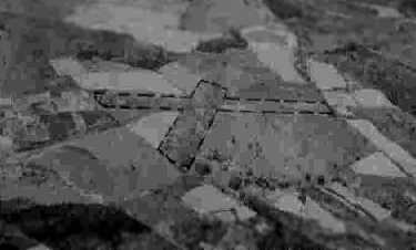
A circa 1942-45 aerial view looking north at the “Pulaski Intermediate Field” from the 1945 AAF Airfield Directory (courtesy of Scott Murdock)
depicted the field as having 2 grass runways.
The directory described Pulaski as a 70-acre cross-shaped field within which were 2 sod runways, measuring 2,650' northeast/southwest & 2,300' NNE/SSW.
The field was said to have a single 40' square wood & metal hangar,
to be privately owned, but operated by the Civil Aeronautics Administration.
Pulaski Field was not depicted at all on the 1945 USGS topo map.
The Haire Publishing Company's 1945 Airport Directory (courtesy of Chris Kennedy)
once again listed the Pulaski airfield as the "CAA Intermediate Field Site #33B" (which may have been erroneous).
It was described as a "class 1" airfield, owned by the City & operated by the CAA (Civilian Aeronautics Administration).
The field was said to have 2 sod runways in an "X" shape:
2,650' northeast/southwest & 2,300' north-northeast/south-southwest.
The manager was listed as M. Lawley.
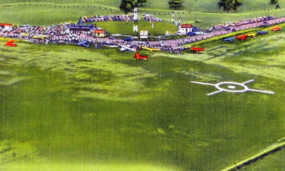
An undated aerial view by David Kent looking southeast at “Pulaski Municipal Airport” from a postcard (courtesy of Don Elmore),
showing a total of 12 aircraft on the field, with a large crowd, presumably at the airport for some kind of event.
At some point between 1945-48 the field gained a new name, Loving Field,
as that is how it was labeled on the October 1948 Winston-Salem Sectional Chart (courtesy of Chris Kennedy).
It was also labeled as Site 35A,
and was described as having a 2,800' unpaved runway.
An operating license for Loving Field was applied for on 1/11/49,
according to the book "Virginia Airports" (published by the VAHS).
The license was granted on 8/23/49 to Porter Ham, as a commercial, turf field.
A 1949 aerial view showing 3 or 4 aircraft parked at Loving Field.
Carl Bryant recalled of Loving Field, “I had my 1st plane ride there in the 1950s.”
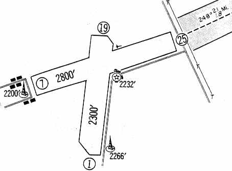
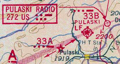
A 1960 approach plate (courtesy of Lester Hollans) depicted Loving Field
as having 2 unpaved runways: 2,800' Runway 7/25 & 2,300' Runway 1/19.
A tower was depicted right at the very end of Runway 25,
which must have made operations from that runway somewhat interesting.
A beacon & 2 small buildings were depicted just southeast of the runway intersection.
It also indicated that Loving Field served as the FAA's Site #35A, along the Nashville-Washington Airway.
According to the book "Virginia Airports" (published by the VAHS),
the operating license for Loving Field was canceled on 11/21/60, at the Town of Pulaski's request.
Loving Field was closed by 1960, as it was no longer listed in the 1960 Jeppesen Airway Manual (according to Chris Kennedy).
It was eventually replaced by the much larger New River Valley in nearby Dublin, which was dedicated in 1962.
Carl Bryant recalled, “In the early 1960s the county built a brand new hard-surfaced airport in Dublin
to promote economic growth & Piedmont Airlines was soon flying Martin 404s into Pulaski County.
When the lights were finally turned out at Loving Field
the complex was quickly overtaken by wildlife & local urchins like myself.
It was a special treat to have our own airport to play with.
I grew up playing on its 2 abandoned airstrips in the 1960s, only a mile or so from my house.”
The 1965 USGS topo map depicted a unpaved runways, labeled as “Landing Field”.
The 1971 USGS topo map depicted the airfield in an unchanged fashion.
The 1978 USGS topo map no longer depicted any airport features at the site of Loving Field.
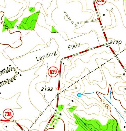
The 1999 USGS aerial photo showed the outlines of the 2 former runways at Loving Field as still quite recognizable,
even though several baseball diamonds had been built over the center of the former airfield.
There were a few small buildings just southeast of the runway intersection which could possibly date from the site's days as an airfield.
As of 2004, the site of the former Loving Field is in use as the Loving Sports Complex,
which consists of 162 acres, 30 of which have been redeveloped into baseball/softball fields).
Some 90 acres are leased to a local farmer, while the remaining is undeveloped, open space.
As of 2004, it appears as if there still may be some aviation use of Loving Field,
as an ultralight aircraft operator mentions flying from the site.
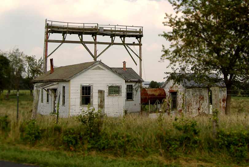
A 2005 photo by Carl Bryant of airfield buildings which remain standing at the site of Loving Field.
“Actually in pretty good shape considering they've been unoccupied for almost 45 years.”
Carl Bryant reported in 2005, “Loving Field is owned by the town of Pulaski & is currently being used as a sports complex.
A number of softball diamonds have been built onto the north end of the north/south runway
and the east end of the east/west runway.
The southern half of the north/south strip is still open grass & is used by local ultralight enthusiasts.
A road runs along the southern edge of the old airport
and 3 original buildings still stand at the intersection of the 2 runways.
There was once a hangar, large enough for 2 aircraft,
about 50 yards east of the 3 remaining buildings & across the road from the softball field parking lot.
The thing I found most unusual about this airport was the fact that all the buildings were across the road from the grass runways.
Planes in the hangar actually had to be pushed across the road & through the grass parking lot to get to the field!
When the airport closed a local farmer used the hanger to store hay
and perhaps this is why it soon fell apart & had to be scrapped.
The tower depicted on the 1960 approach plate on the southeast end of the north/south runway
is a large farm building, a silo I think.
The tower shown at the west end of the east/west runway is a church.”
A 2007 aerial view looking north showed the outlines of the 2 former Loving Field runways were still quite recognizable,
even though several baseball diamonds had been built over the center of the former airfield.
There were a few small buildings just southeast of the runway intersection which could possibly date from the site's days as an airfield.
A 2012 photo looking east at the former airfield buildings on the southeast side of the Loving Field site.
The radio antenna wooden structure seen in the 2005 photo was evidently removed at some point between 2005-2012.
The site of Loving Field is located west of the intersection of Alum Spring Road & Loving Field Road, appropriately enough.
Thanks to Lester Hollans for pointing out this airfield.
____________________________________________________
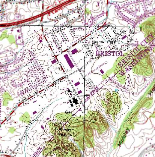
Harkrader-Kilgore Airport / Bristol Airport, Bristol, VA
36.62, -82.126 (Northwest of Charlotte, NC)
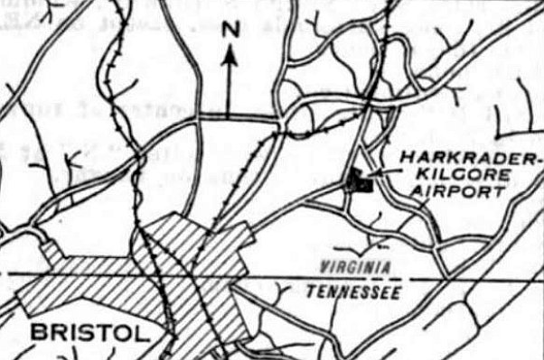
Harkrader-Kilgore Airport, as depicted on the 1/10/30 Commerce Department Airway Bulletin (courtesy of Mike Denja).
According to the website of the present-day Tri-Cities Regional Airport,
"Bristol’s airport got its start in 1923, when Charles Harkerader, owner of the Bristol Herald Courier,
and another local businessman opened a landing field 2 miles east of Bristol, Virginia.
Known simply as the Bristol Airport, the field had 2 grass runways & a metal hangar.
The privately-owned airport usually had 8-10 based aircraft at any one time."
According to the website of the present-day Tri-Cities Regional Airport, "About 1930, the owners of the Bristol Airport started a flying business
in the hopes of generating some commercial activity at the field.
They bought 2 airplanes & hired a pilot, but customers were scarce during the depression.
Charles Harkerader knew that 19-year old Jane Dulaney was interested in flying & decided that teaching her would stimulate business.
Jane jumped at the chance. She quickly soloed & earned her license.”
The earliest depiction which has been located of Bristol's airport was on the 1/10/30 Commerce Department Airway Bulletin (courtesy of Mike Denja),
which listed it as Harkrader-Kilgore Airport.
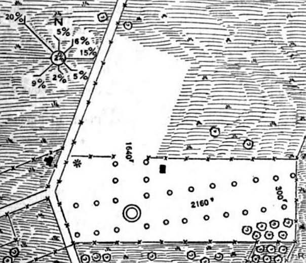
The 1/10/30 Commerce Department Airway Bulletin (courtesy of Mike Denja) described Harkrader-Kilgore Airport as a municipal airport, owned & operated by the City of Bristol.
It was said to consist of a 85 acre L-shaped “chert soil” field measuring 2,160' east/west & 1,640' northeast/southwest.
One small building was depicted northeast of the runway intersection.
According to the website of the present-day Tri-Cities Regional Airport, "It was 1933 before Bristol was officially designated on the nation's aviation map.
An airline known as the Ludington Line, which operated passenger service between Washington D.C. & New York City
was exploring the possibility of opening mail routes in the south.
A route from D.C. to Nashville with stops at Kingsport & Knoxville was considered.
By the spring of 1933, Eastern Air Transport purchased the Ludington Line & carried through on the plan.
Eastern made several test flights to Bristol to determine local interest before adding the city to its mail route known as 'CAM-23'.
The local backing was there, and the Tri-Cities area received its 1st air service through the Bristol Airport."
According to the website of the present-day Tri-Cities Regional Airport, "In February of 1934 the government canceled all airline mail contracts due to a bidding controversy.
President Roosevelt turned the air mail business over to the Army. It was a disastrous decision.
Army pilots, unfamiliar with the routes, flew open-cockpit planes during one of the worst winters in years.
In the 1st week, plane crashes killed five pilots & 6 were critically injured.
There was an immediate public outcry & Roosevelt conceded that the idea had been a mistake.
New airline bids were called for & by mid-May the airlines returned to flying the mail.
The route Eastern had previously flown through Bristol to Nashville was won by American,
which continued the service flying Stinson 'Model A' Tri-Motors.
It was during this period that a well-known local aviator named Louis Hilbert
established Appalachian Flying Service at the Bristol Airport.
It would become one of the oldest continuously-operated FBOs in Tennessee.”
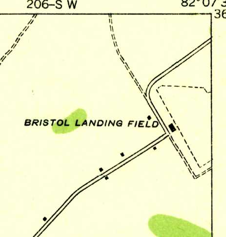
The earliest topo map depiction which has been located of Bristol Airport was on the 1934 USGS topo map.
It depicted Bristol Landing Field as an irregularly-shaped outline with a single building at the west side.
According to the website of the present-day Tri-Cities Regional Airport,
"By the mid-1930s Kingsport & Johnson City were trying to obtain their own air service.
Johnson City’s privately owned airfield was not large enough to be practical.
A grass airstrip in the Lovedale section of Kingsport was also too small & lacked public support for expansion."

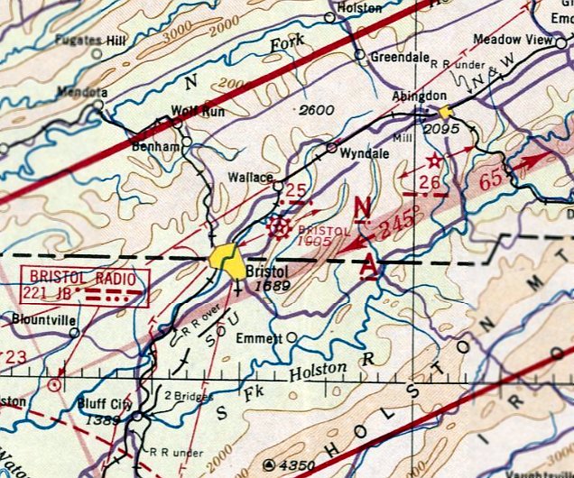
The earliest aeronautical chart depiction which has been located of Bristol Airport was on the March 1935 Winston-Salem Sectional Chart.
It depicted Bristol as a commercial/municipal airport.
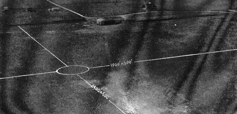
The 1/1/36 Department of Commerce Airway Bulletin described Bristol as a municipal airport as a commercial field, consisting of an irregularly-shaped sod field.
It was said to have 2 runways: 2,400' northeast/southwest & 1,900 northwest/southeast.
A hangar was said to be marked with “Bristol Airport” on its roof.
The field was said to offer facilities for servicing aircraft, day only.
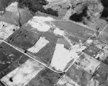
An August 1936 aerial view looking east depicted Bristol Airport as consisting of a rectangular grass field.
An aerial photo looking southwest at the Bristol Airport from The Airport Directory Company's 1937 Airports Directory (courtesy of Bob Rambo).
The field was described as having 2 sod runways, with the longest being the 2,400' northeast/southwest strip.
A single hangar depicted in the aerial photo in the directory was said to have "Bristol" marked on the roof.
According to the website of the present-day Tri-Cities Regional Airport,
"The dilemma was eventually solved when all 3 cities cooperated with Sullivan County
to build a regional airport equidistant between them.
When the new airport opened in 1937, the facility in Bristol reverted to private flying.”
Universal Aircraft reportedly produced 19 L-7 liaison aircraft in Bristol, VA during WW2, at a facility with a USAAF plant code of “UN”.
The L-7s were Monocoupe 90AFs which were delivered to the USAAF & used in France.
The last aeronautical chart depiction which has been located of Bristol Airport was on the January 1942 Winston-Salem Sectional Chart.
It depicted Bristol as a commercial/municipal airport.
Bristol Airport was evidently closed (for reasons unknown) at some point int 1942,
as it was no longer depicted on the August 1942 Winston-Salem Sectional Chart.
The 1960 USGS topo map continued to depict “Bristol Landing Field” as an irregularly-shaped outline with a single building at the west side.
The 1962 USGS topo map no longer depicted Bristol Airport,
instead showing several streets having been built through the site.
According to Shawn Carver, the site of the Bristol Airport "is located on Old Airport Road near I-81.
I believe it was located on the site of what is now an industrial warehouse area.
The 1st place I ever lived in (until I was 1 year old) is directly behind this site.
I have always been told that the warehouse area is the site of the old Bristol Airport.”
The 1981 USGS topo map also still depicted an "Airway Beacon" on a hill just to the south of the site of the former airport,
but did not depict any other traces of the former airport.
The 1991 USGS topo map still depicted an "Airway Beacon" on a hill just to the south of the site of the former airport.
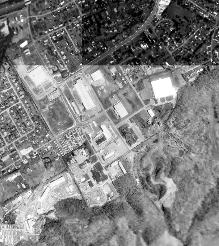
As seen in the 1997 USGS aerial photo of the site of Bristol Airport,
Shawn Carver pointed out that "there appears to be at least one Quonset hut style building
which might just be one of the original airport buildings."
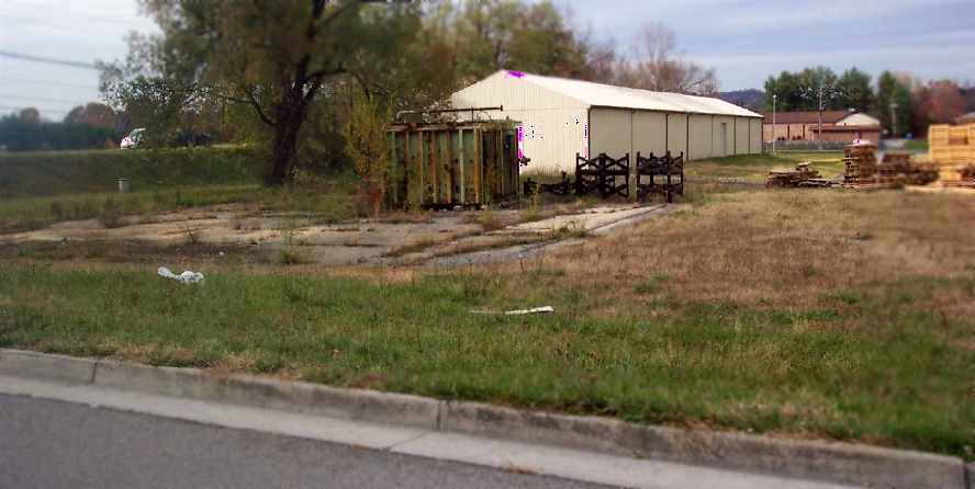
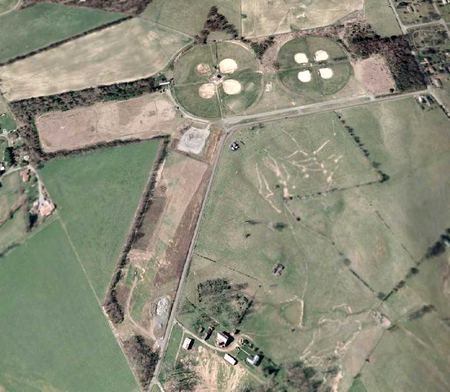
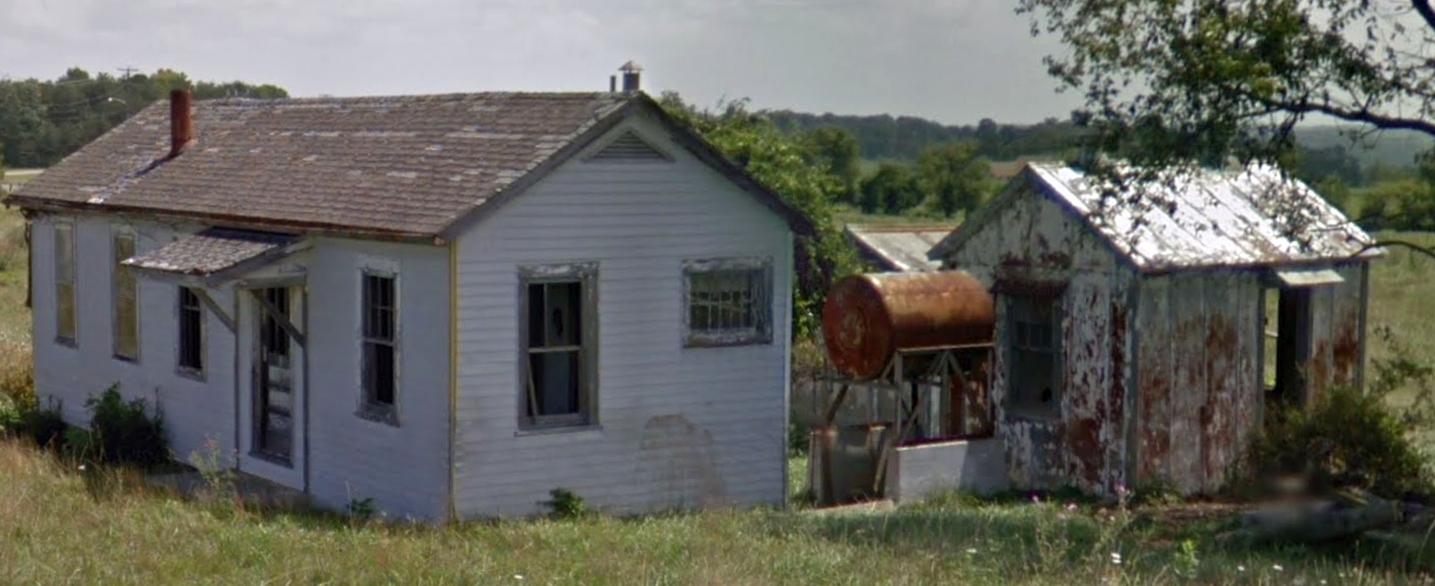
A 2007 photo by Steve Matda looking northwest at the foundation of the Bristol Airport hangar.
Steve reported, “Bonham Road is to the left on the embankment & runs behind the trees & tan warehouse.
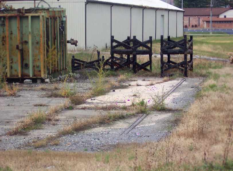
A 2007 closeup photo by Steve Matda looking northwest at the foundation of the Bristol Airport hangar,
“showing metal channel in concrete for the hangar door.”
____________________________________________________
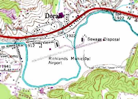
Richlands Municipal Airport (7A4), Richlands, VA
37.09, -81.836 (Southwest of Roanoke, VA)
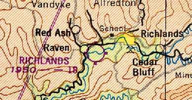
Richlands Airport, as depicted on the 1949 Winston-Salem Sectional Chart (courtesy of Chris Kennedy).
According to the book "Virginia Airports" by Vera Rollo & Norman Crabill (published by the VAHS),
an operating license for Richlands Airport was applied for in 11/14/44 by Hubert Altizer of "Clinch Valley Airways".
The license was granted on 2/5/43 [which doesn't make sense, as it was 'applied for' in 1944],
and was later transferred to John Mullins & George Fitch.
According to an article in a 1992 issue of the Richlands News Press (courtesy of Frank White),
“The Richlands Airport was begun on 3/22/45, by Herbert Altizer & Grady Dalton on the Davis-Smith property.”
From 1945-52 the Richlands Airport operator & owner was Grady Dalton.
The earliest depiction of Richlands Municipal Airport which has been located
was on the 1949 Winston-Salem Sectional Chart (courtesy of Chris Kennedy).
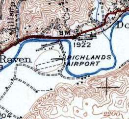
The 1950 USGS topo map depicted Richlands Airport as having a single unpaved northeast/southwest runway.
According to Frank White (who learned to fly, and made his 1st Solo from Richlands Airport in 1976),
the original Richlands Airport "was a grass strip located just across the Clinch River, to the west of the [current paved runway] airport.
In fact, one could stand on the end of the paved Runway 8, and almost throw a rock to the east end of the old grass runway, which is now a subdivision."
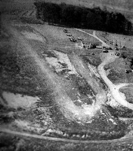
A undated (circa 1950s?) aerial view from an article in a 1992 issue of the Richlands News Press,
looking west-northwest at the original unpaved Richlands runway (courtesy of Frank White).
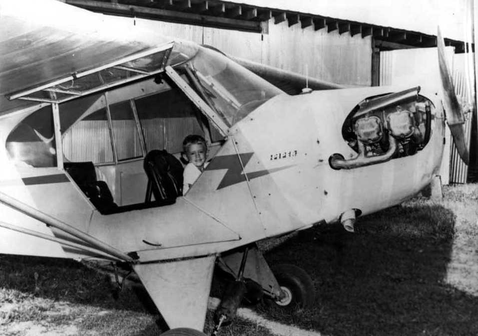
The earliest photo which has been located showing an aircraft at the Richlands Airport was a late 1950s photo of Buster Roisch in a Piper Cub.
In the words of Frank Grose, "The old airport (west of the river) was still in operation in 1961 or 1962.
I got my 1st airplane ride from there in a Cherokee 140,
from some fellow by the name of Shultz, who had dreams of starting an FBO there.
My 2nd ride was also from that field in Grady Dalton's Super Cub with Fleet Underwood (a Hellcat pilot in the Pacific during WW2).
He let me do most of the flying. That was the 1st time I'd touched the controls of an airplane, but I recall it like it was yesterday.
We took off west, and made a tear-drop turn back toward the airfield.
Fleet gave me the controls as we approached the airport. It felt good!
My inner voice said to me, 'This is what you HAVE to do.' That was the moment I became a pilot.
By the time I started taking lessons in the early summer of 1963, the new airport had been opened.
And it was still 'new' that summer. Later, Bob Mullens got Bill Haymaker to come to be the instructor.
I flew with him a couple of times in a Cessna 150 in 1964."
The 1967 Shell Airport Directory (courtesy of Kevin Walsh) depicted Richlands Municipal Airport
as having a single paved 2,000' Runway 8/26.
Richlands Municipal Airport was listed in the 1968 VA Airport Directory as Richlands Flying Service,
with a single 1,900' sod Runway 9/27.
According to Chris Kennedy, the 1971 Flight guide described Richlands Airport as having an 1,800' unpaved runway.
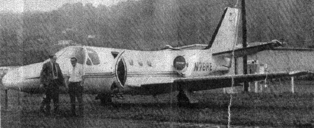
A Fall 1974 photo of Charles Toman & James Hackman in front of the Reliance Electric Company Cessna Citation they had just landed at Richlands.
Jim Hackman recalled, “It was probably part of a multi-stop day.
The Citation replaced a B90 King Air & we had a lot of small short places to accommodate.
The water across the Richlands runway also occurred on our visit.
After we landed it rained & the drainage ditch visible on the drawing rose over the runway.
There was room to rotate before the flooded spot & in case of a rejected takeoff the water would have slowed us down.”
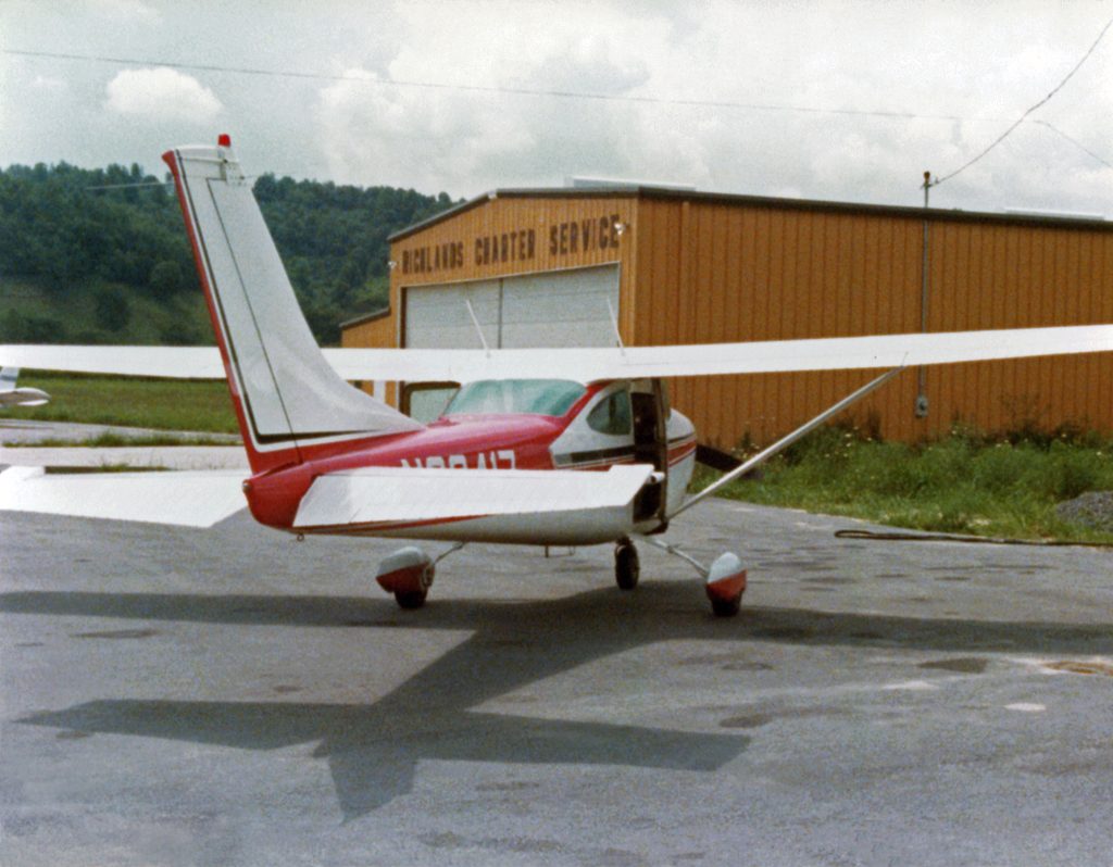
An 8/12/77 photo By Kenneth Keeton of a Cessna 1982 in front of the Richlands Charter Service hangar.
The 1978 USGS topo map depicted Richlands Municipal Airport as having a single paved runway,
which had evidently replaced the grass runway at some point between 1971-78.
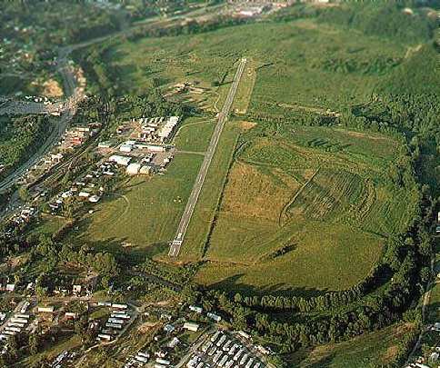
A 1981 aerial photo by Frank White looking east at Richlands Municipal Airport, while the airport was still open.
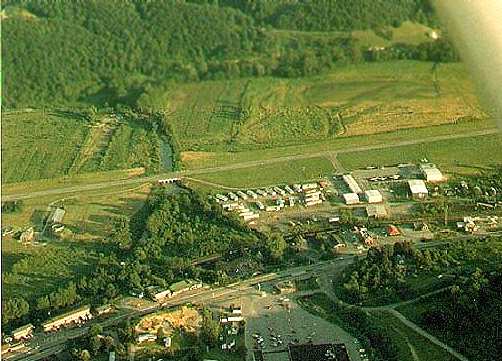
A 1981 aerial photo by Frank White looking south at Richlands Municipal Airport,
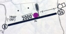
showing the bridge (center-left of photo) which carried the runway over the Clinch River.
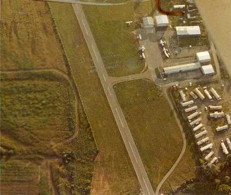
A 1981 closeup by Frank White of the ramp at Richlands Municipal Airport.
Frank observed, “Looking at this picture, I can still smell the fresh-cut grass as if it were this morning sometime."
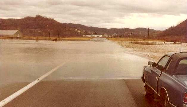
A 1981 photo by Frank White of floodwaters over the runway at Richlands Municipal Airport.
"Here's what typically happened on the runway after a couple days of rain! Yikes!
…the results of the wondrous idea of building an airport OVER a flood prone river,
in a flood prone river basin."
The paved runway extended further to the east, being carried by a bridge across the Clinch River.
However, even that was apparently not enough to handle the water,
as Frank White recalled "whenever it rained a lot, the airport would have to close because of flooding."
By the time of the 1982 AOPA Airport Directory (courtesy of Ed Drury),
the airfield consisted of a single 3,427' asphalt Runway 8/26.
Frank White added, "An interesting story surrounds the old airport.
In the early 1960s, a banker in Richlands [Grady Dalton] organized a Civil Air Patrol detachment,
and was able to acquire a Super Cub, under some kind of state grant, for use with the CAP.
When the airport moved across the river, the CAP detachment dissolved,
and the banker stored the Cub in a small makeshift hangar
(which was actually someone's garage at the edge of the airport property).
Well, Virginia never came & picked up the airplane, and there it sat for years & years.
I remember going over to that old building,
crawling up & looking through the little window on the side of the building to see the dust covered Cub, rotting away inside."
Frank continued, "No one in the State was aware of the airplane during the years it sat in that little building
because the paperwork had obviously fell through the cracks,
so theoretically, it didn't belong to anyone from the time the CAP disbanded until Mr. Dalton passed away."
Around 1987, after the Banker died, the record of it finally came to light & the State came & reclaimed the airplane."
Mike Hoover reported that he landed at Richlands in 1989, and that there was an FBO & fuel.
According to Frank White, Richlands Municipal Airport officially closed on 6/2/92,
after having been replaced by the new Tazewell County Airport, a few miles to the southeast.
A 2/1/07 aerial view looking east at the site of the original Richlands Municipal Airport showed the runway remained intact, with some markings still visible.
The ramp appeared to be used for storage.
Richlands Municipal Airport is located on the south side of Route 460, 1 mile west of the town of Richlands.
____________________________________________________
Since this site was first put on the web in 1999, its popularity has grown tremendously.
If the total quantity of material on this site is to continue to grow,
it will require ever-increasing funding to pay its expenses.
Therefore, I request financial contributions from site visitors,
to help defray the increasing costs of the site
and ensure that it continues to be available & to grow.
What would you pay for a good aviation magazine, or a good aviation book?
Please consider a donation of an equivalent amount, at the least.
This site is not supported by commercial advertising –
it is purely supported by donations.
If you enjoy the site, and would like to make a financial contribution,
you
may use a credit card via
![]() :
:
Please consider checking the box to make a monthly donatation.
For a mailing address to send a check, please contact me at: paulandterryfreeman@gmail.com
If you enjoy this web site, please support it with a financial contribution.
please contact me at: paulandterryfreeman@gmail.com
If you enjoy this web site, please support it with a financial contribution.
____________________________________________________
This site covers airfields in all 50 states.