Abandoned & Little-Known Airfields:
Virginia: Southern Richmond area
© 2002, © 2023 by Paul Freeman. Revised 5/27/23.
____________________________________________________
Please consider a financial contribution to support the continued growth & operation of this site.
Berkeley Field (revised 5/27/23) - Colonial Heights Airport (revised 8/11/19) - Fort Lee AAF (revised 5/27/23)
Hopewell Airport (revised 4/14/21) - Parnell Airport (revised 12/1/21)
____________________________________________________
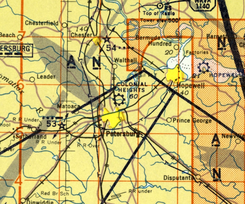
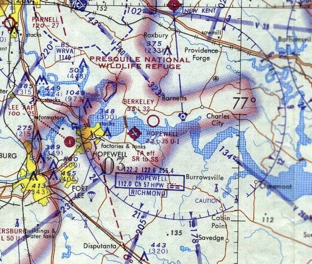
Fort Lee Army Airfield, Petersburg, VA
37.284, -77.345 (South of Richmond, VA)
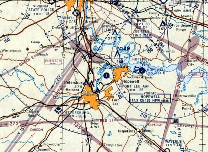
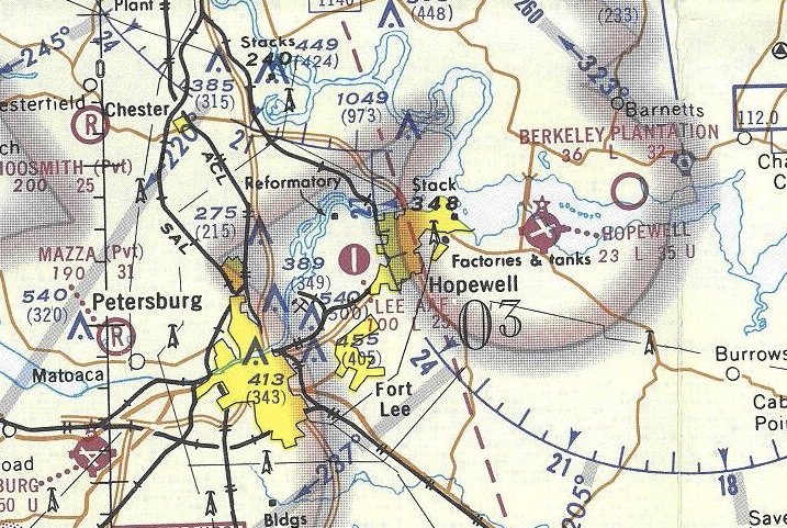
Fort Lee AAF, as depicted on the January 1960 Norfolk Sectional Chart.
The Fort Lee AAF was apparently built at some point between 1959-60,
as it was not depicted on the 1955 USGS topo map, a 1955 aerial photo, or the July 1959 Norfolk Sectional Chart.
The earliest depiction of Fort Lee AAF which has been located was on the January 1960 Norfolk Sectional Chart.
It depicted Fort Lee AAF as having a single 2,500' asphalt runway & its own control tower.
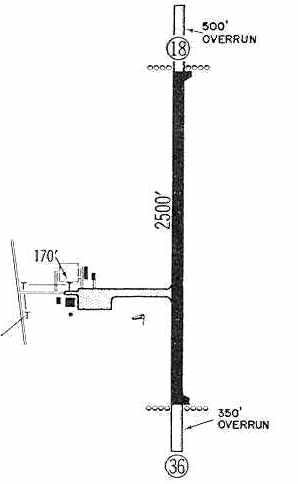
The 1960 Jeppesen Airway Manual (courtesy of Chris Kennedy) depicted Ft Lee AAF as having a single 2,500' paved Runway 18/36,
with a 500' overrun on the north end & a 350' overrun on the south end.
A taxiway led to a ramp on the west side of the runway with several small buildings (hangars?).
Bill Drumright recalled that the Fort Lee Airfield "was built by diverting funds approved by Congress
for barracks, sidewalks, etc. on Fort Lee to the airfield project.
A Fort Lee Commander had requested the airfield be built, but was turned down by the Pentagon/Congress.
In addition to being told no to funding, the FAA had conducted a site review
and found the proposed location had flight restrictions which made it unsuitable,
mainly I believe the problem of one of the approaches being directly over the Federal Penitentiary & water tower."
Drumright continued, "I first heard of the 'Infamous' airfield when I was stationed at Fort Lee in the 1970s.
I was attending a government (read Army) contracting officer course at the Army Logistics Management Center located on Fort Lee.
The instructors used the incident of the Airfield as a teaching tool because it showed so many violations of contracting law.
Everything from diverting funding approved by Congress for specific construction
to undue Commander influence being placed on the Contracting Officer involved to falsify contracts & 'make it happen'.
The last time I was there, there still existed a permanent, brick I believe, barracks building in the shape of an 'L'.
The barracks was suppose to be in the shape of a 'U'.
The missing wing in the 'L' shaped one happened because the money for that wing was used in building the unauthorized airfield."
Drumright continued, "As to why the Commander wanted an airfield,
I can only relate to you what I was told during the contracting officer class.
At the time it was built, Army Aviation was the up & coming thing in the Army,
and more as a status symbol than anything else,
one of the 'requirements' of a Commanding General was to have an airfield.
It also seems to me that the General lost his Legion of Merit award & was forced to retire."
Fort Lee AAF was still depicted on the 1965 Norfolk Sectional Chart (courtesy of John Voss),
but it evidently no longer had an operating control tower.
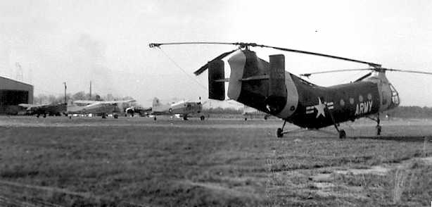
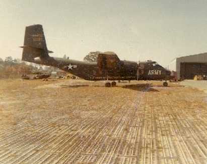
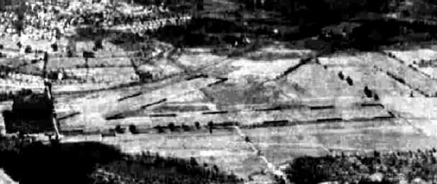
The earliest photo which has been located of Ft. Lee AAF was a January 1965 photo by Steve Yannone,
showing an Army CH-21 helicopter on the grass in front of several L-19s, Beavers, Caribous, and a hangar.
Steve recalled, “Ft Lee VA... where I was stationed in the Army 1964-66.
I was the crew chief on this CH-21 helicopter, the only helicopter stationed there.
Notice they have me parked as far from the hangar as possible off the ramp on planked steel planking, I wonder why.
There was just one hangar with a small supply building behind it.
The tower was just either walking out of operations building attached to the hangar or looking out the window, no real tower.
We did jump hundreds of riggers & the sport parachute team from Ft Lee, even the Army's Golden Knights while they were there testing some new chutes.
We also flew in several air shows at some small local airfields.
There were several Army fixed-wings: L-19s, Beavers, and one Caribou.
The Air Force had a couple Beavers but not as permanent station; there was a communications center at Lee that they brought people in for a few days at a time.
The prison off the end of the runway... we were to turn out to the East as soon as possible to avoid direct flight over it.”
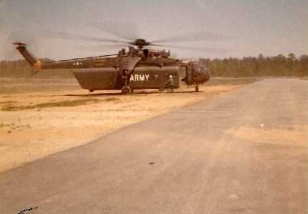
A May 1965 photo by Steve Yannone of an Army Sikorsky CH-54 Tarhe Skycrane with an underslung cargo pod at Fort Lee AAF.
Steve recalled, “I sure wanted to take a ride in this flying crane!”
A May 1965 photo by Steve Yannone of an Army Cessna O-1 Bird Dog & a De Havilland CV-2 Caribou on pierced steel planking in front of Fort Lee AAF's hangar.
Steve recalled of the Caribou, “Slow, low and reliable!”
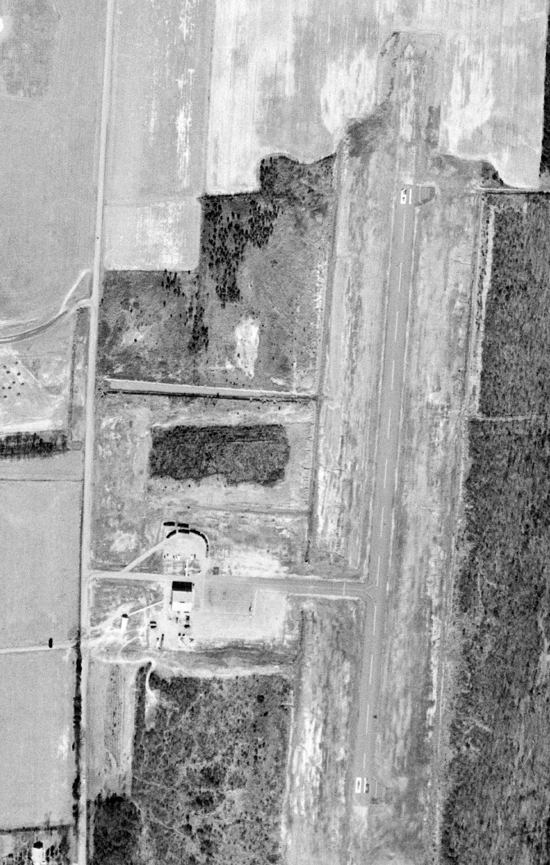
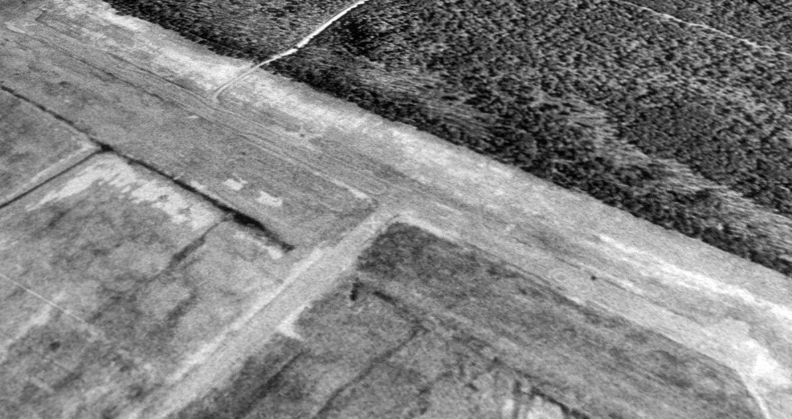
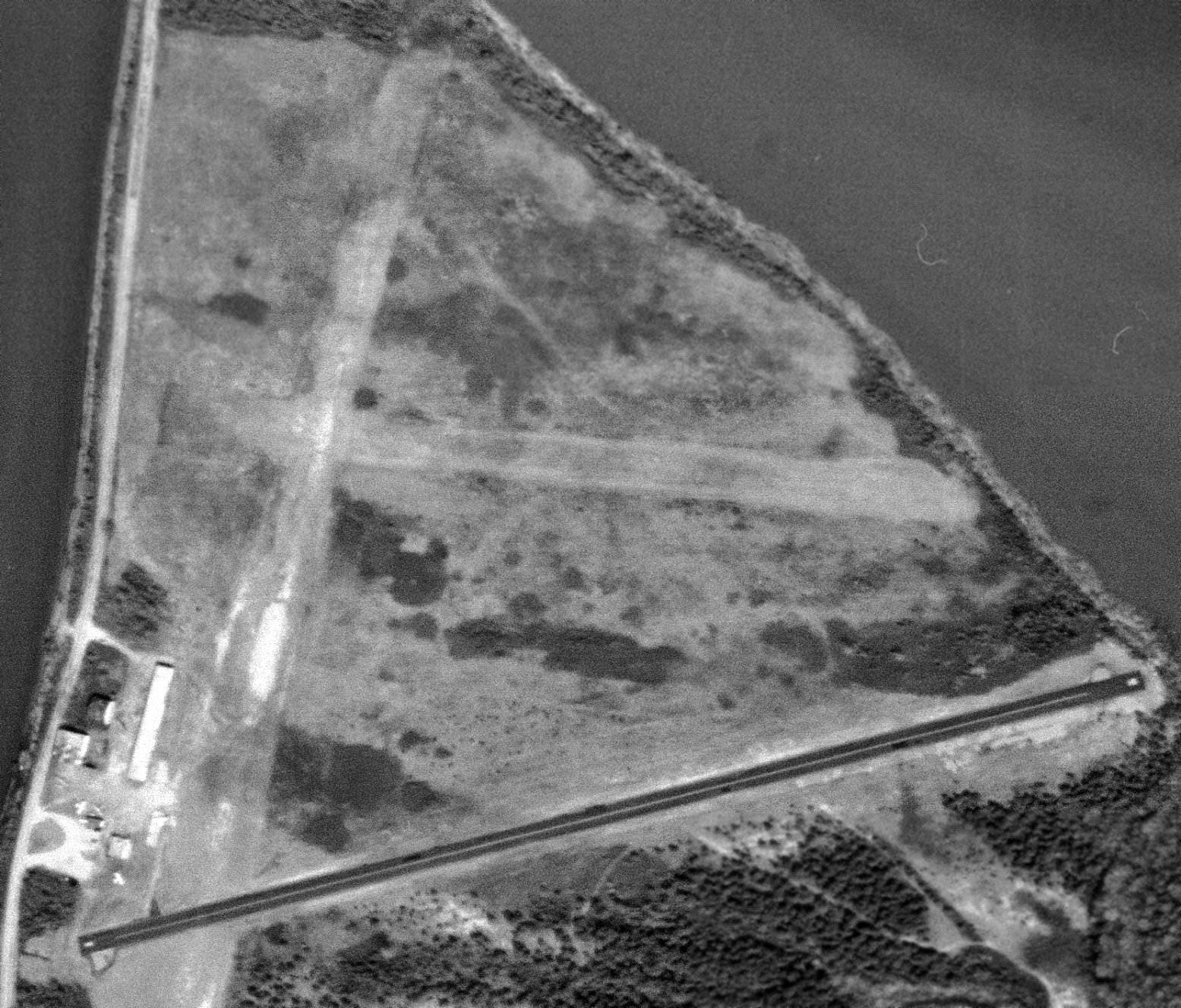
The earliest photo which has been located of Ft. Lee AAF was a 2/25/68 USGS aerial view.
It depicted Ft. Lee AAF as consisting of a single asphalt Runway 1/19,
with a paved taxiway leading to a single building on the west side.
Ken Pepper recalled, “When I returned from Vietnam in mid 1968 I was assigned to Lee AAF.
As I recall there was no tower. All communication was done from the office, manned by SSgt Wayne Redmond.
I also don't remember any running water at the airfield.
My MOS was 67B20 crew chief O-1 Birdogs. There were none of these at the airfield.
We did have a Ping Pong table in the hangar & played many a heated game there.
I left the Army in Sept 1969; several years later I went back & there was no buildings left standing, just the floor tiles that spelled Lee AAF.”
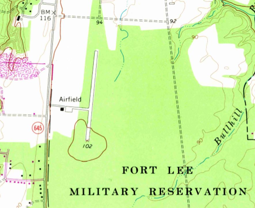
The 1969 USGS topo map depicted the Ft. Lee “Airfield” as having a single paved north/south runway,
with a taxiway, ramp, and a single building on the west side.
The last aeronautical chart depiction which has been located of Fort Lee AAF was on the 1971 Norfolk Sectional Chart,
which depicted Ft Lee AAF as having a single paved 2,500' north/south runway.
The Fort Lee Airfield was apparently closed at some point between 1971-72,
as it was not depicted at all (not even as an abandoned airfield)
on the 1972 Washington Sectional Chart (courtesy of Mike Keefe).
Steve Yannone recalled of Ft. Lee AAF, “I went back somewhere around 1975 & the buildings were gone, even the windsock.”
The Ft. Lee runway was still depicted on the 1981 USGS topo map, but it was labeled simply as "Airfield".
According to Robert Lee, “the Mid-Virginia Radio Control Club has had a year-to-year agreement with the Army to use a grass area west of the paved strip” since the 1980s.
A 1994 USGS aerial view looking northeast showed the Ft Lee AAF runway still existed in relatively good condition.
The runway was still depicted on the 1996 USGS topo map, but it was labeled simply as "Airfield".
Bill Drumright recalled in 2003, "The airfield was never really used as an airfield.
Someone blew the whistle on the scandal before it became fully operational.
I know from having lived in that area off and on for the last 20+ years
that it has been used as a Drop Zone by the parachute riggers,
who were trained by the Quartermaster School at Fort Lee, and a few times I have noticed model airplanes using it.
The last I heard, it is still on government property.
The hangars were removed years ago & I don't think the fuel storage tanks are still in place."
Peter Hantelman reported in 2006, “A sectional chart shows only a parachute drop zone
(for the parachute riggers, which they never use), but no airfield, not even abandoned.
I have driven by the field several times, and it's in great shape!
I've seen active fields that are in poorer condition, and this one absolutely doesn't look like it was last used in the 1960s.
All that's left is a small windsock, one set of bleachers, and a dumpster.”
Virgil Hill reported in 2007, “I am a pilot in the Virginia Army National Guard at Richmond International Airport.
I fly Blackhawks for the 2/224th Aviation Battalion. The old Ft. Lee strip is used very often by our unit.
We do training there probably 3 times a week, including roll-on landings.
The Army uses the site to teach sling-load rigging to AIT students.
My unit will fly in & let them hook up a water blivet, which we will fly for a moment & set it back down again.
We spend a lot of time there.”
Robert Lee reported in 2013, “I retired from Ft. Lee in 2005 and in fact, it was used as a drop zone for for many years until 2010,
when a parachutist was blown into power lines on the west edge of the drop zone & was killed.
Because of the cost that would be involved in burying or rerouting the power lines, parachute training has been moved to Ft. Pickett, Va.
The airstrip is used frequently by military helicopters for training & on some weekends, as a driver training site.
In the past 16 years, because of the stigma attached to it, no maintenance of any kind has been performed on the paved strip.
It might not have been authorized, but it was well built!
I'm the Secretary/Treasurer of the Mid-Virginia Radio Control Club,
which has had a year-to-year agreement with the Army to use a grass area west of the paved strip for more than 30 years.
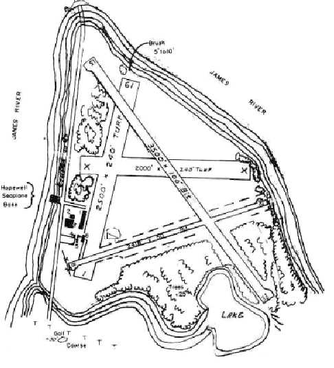
You can see our parking area & 500' x 80' [grass] runway directly west of the north end of the paved strip.”
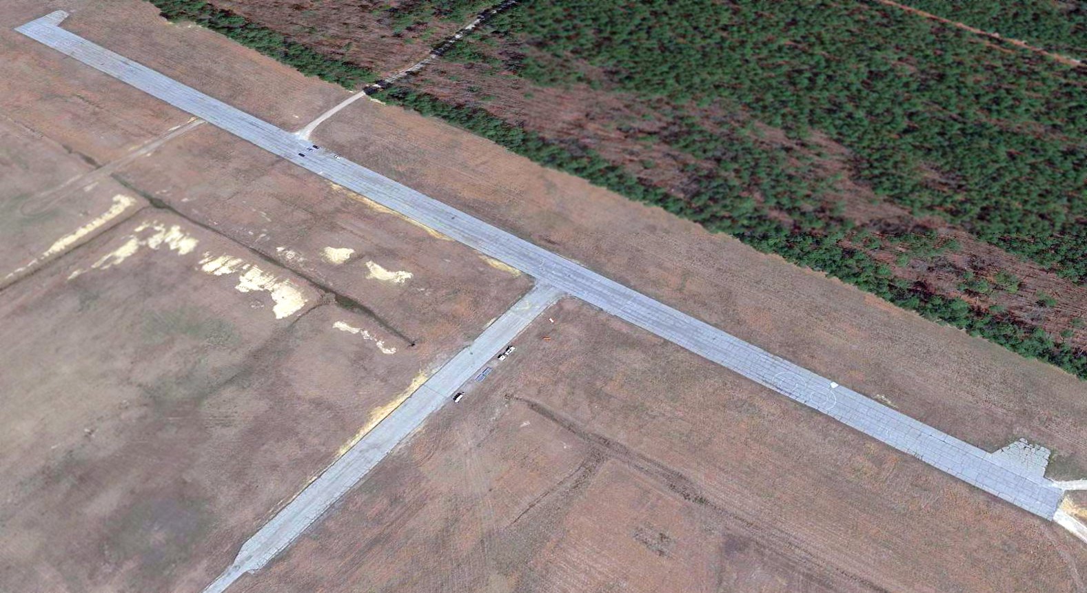
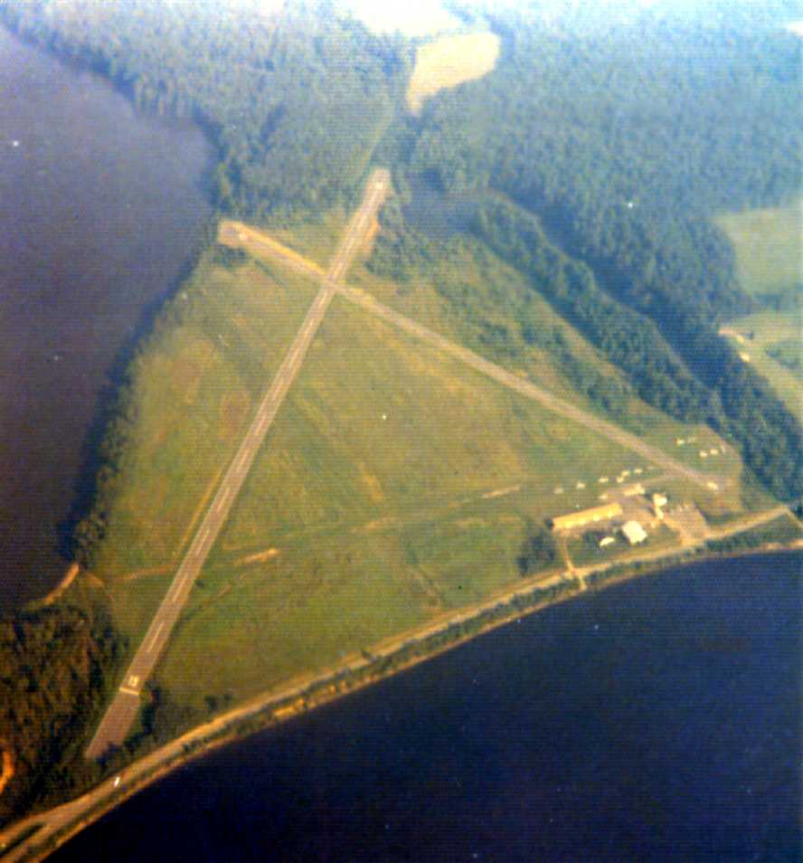
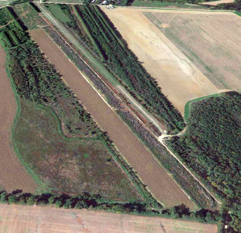
A 2017 USGS aerial view looking northeast showed the Ft Lee AAF runway remained intact, although markings appeared to have been added for some kind of vehicle course.
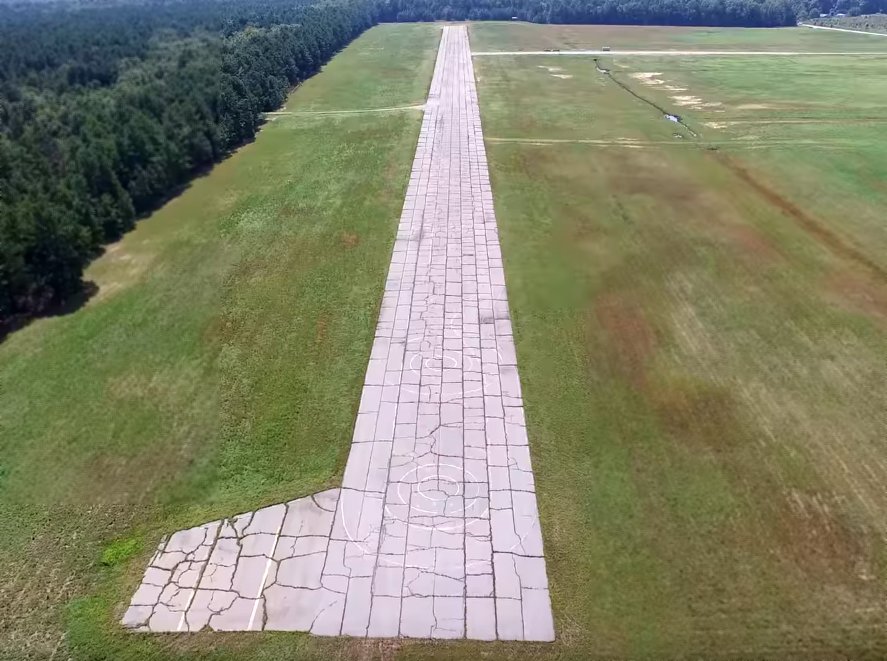
A still looking south at the Ft. Lee airfield from a drone video by Jack Fessler, showing the Ft. Lee runway remains intact though heavily cracked.
Robert Lee reported in 2017, “Ft. Lee Air Field... Our flying club, the Mid-Virginia Radio Control Club,
just renewed our license to fly in that area for 2018 - we have been flying there for more than 40 years.
We used to fly off the strip, but the firing ranges were expanded & put it in the small arms impact area, so we moved northwest to be able to fly when live fire was being conducted.”
However, Robert Lee reported a sad turn of events in 2020: “After 40-plus years, the Mid-Virginia Radio Control Club closed its flying field at the infamous Ft. Lee Airfield.
As as a knee-jerk reaction to the unsafe & illegal operation elsewhere of drones by a few unregulated fliers,
the Department of Defense banned all operation of privately-owned radio-controlled aircraft from military installations.
Although we never had a complaint, flew no camera-equipped aircraft & remained in our designated area, we got evicted nonetheless.
Was a sad day as we left one of the best radio-controlled fields on 31 December.”
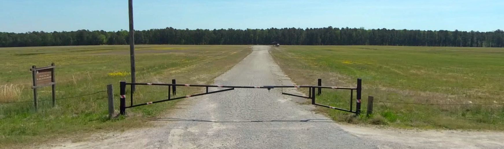
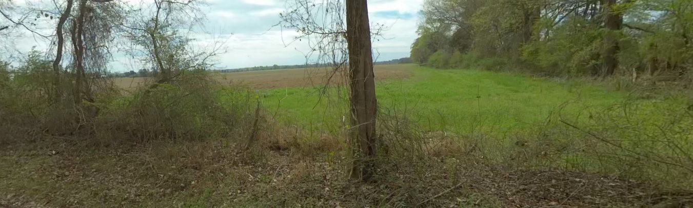
A 2022 photo looking east at the Ft. Lee airfield.
____________________________________________________
Colonial Heights Airport, Colonial Heights, VA
37.248, -77.391 (Southeast of Richmond, VA)
Colonial Heights Airport, as depicted on the March 1943 Norfolk Sectional Chart.
This small general aviation airport may have been established at some point between 1941-43,
as it was yet depicted on the July 1941 Norfolk Sectional Chart.
Colonial Heights Airport was not depicted on USGS topo maps from 1942, 1944, 1945, or 1946.
The earliest depiction which has been located of Colonial Heights Airport was on the March 1943 Norfolk Sectional Chart.
It depicted Colonial Heights as a commercial/municipal airport.
The earliest photo which has been located of Colonial Heights Airport
was a 9/10/43 aerial view looking west from the 1945 AAF Airfield Directory (courtesy of Scott Murdock).
It depicted Colonial Heights as having 2 unpaved runways.
The 1945 AAF Airfield Directory (courtesy of Scott Murdock) described Colonial Heights Airport
as a 140 acre irregularly-shaped property having 2 sod runways, measuring 2,500' northeast/southwest & 2,000' north/south.
The field was said to not have any hangars, and to be owned & operated by private interests.
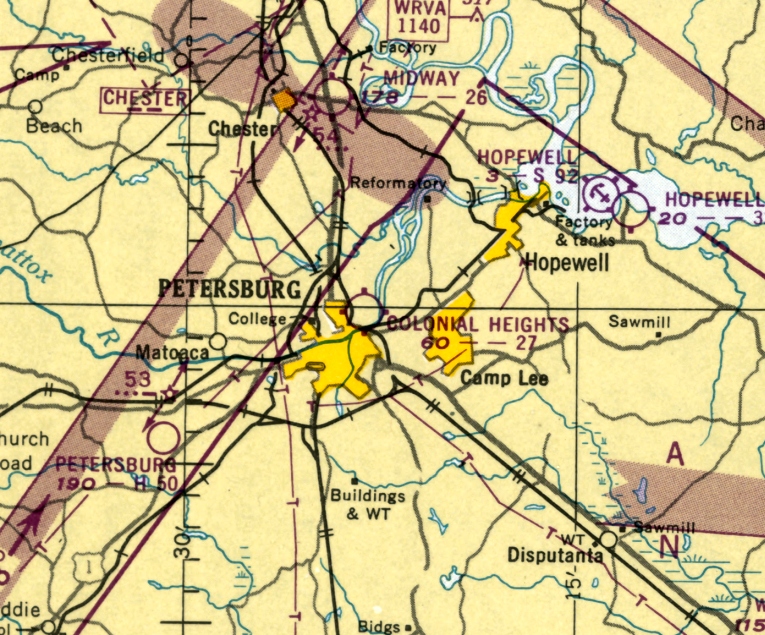
The 1945 AAF Airfield Directory (courtesy of Scott Murdock) described Hopewell Airport
as a 194 acre irregularly-shaped property within which were 3 sod runways, the longest being a 2,400' northwest/southeast strip.
The field was said to have a single 66' x 60' wood & steel hangar,
to be owned by the City of Hopewell, and to be privately operated.
According to the book "Virginia Airports" by Vera Rollo & Norman Crabill (published by the VAHS),
“Colonial Heights Airport... private-commercial operation with 2 turf strips.
Application for license applied for 12/28/45; granted 2/28/46.”
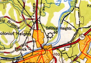
The last depiction which has been located of Colonial Heights Airport was on the 1949 USGS topo map.
It depicted Colonial Heights as a commercial/municipal airport.
According to the book "Virginia Airports" by Vera Rollo & Norman Crabill (published by the VAHS),
“Colonial Heights Airport... license canceled 6/6/49, as operator W.T. Combs moved to operate the Harkrader-Kilgore Airport.”
The last aeronautical chart depiction which has been located of Colonial Heights Airport was on the January 1950 Norfolk Sectional Chart.
It depicted Colonial Heights as having a 2,700' unpaved runway.
Colonial Heights Airport was no longer depicted on the 1952 USGS topo map nor on the 1954 Norfolk Sectional Chart.
A 1955 aerial photo showed 2 unpaved runways, but no aircraft were seen.
The 1959 USGS topo map presumably showed another reason for the closure of Colonial Heights Airport:
the western portion of the airfield property had been covered by the new Interstate 95.
A 1968 aerial photo showed what appeared to be the outline of the former north/south runway, adjacent to the east side of Interstate 95.
A 1994 USGS aerial photo showed that commercial buildings had covered the site, erasing any trace of Colonial Heights Airport.
A 10/21/12 aerial view did not show any trace of Colonial Heights Airport.
The site of Colonial Heights Airport is located northeast of the intersection of Interstate 95 & Southpark Boulevard.
____________________________________________________
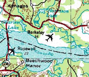
Hopewell Airport (W89), Hopewell, VA
37.306, -77.22 (Southeast of Richmond, VA)
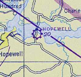
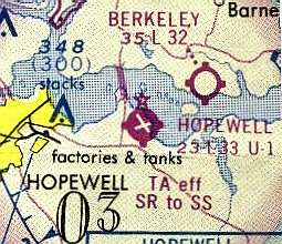
Hopewell Airport, as depicted on the March 1935 Norfolk Sectional Chart..
This small former airport was located on Jordan Point, which juts from the southern shore of the James River.
Jordan Point was named after Samuel Jordan, who lived there in 1619. It was acquired by Theodorick Bland in 1656.
In 1671 Richard Bland I inherited the plantation, then Richard Bland II in 1720.
According to the book "Virginia Airports" by Vera Rollo & Norman Crabill (published by the VAHS),
an operating license for a "City of Hopewell Municipal Airport" was applied for on 4/18/28,
and was granted on 6/15/31 [even back then the bureaucracy took three years to approve an application!].
The earliest directory reference to the airfield which has been located
was in The Airport Directory Company's 1933 Airport Directory (courtesy of Chris Kennedy).
It described Hopewell as a municipal airport, consisting of a triangular 194 acre sandy clay field,
measuring 3,150' northwest/southeast, 2,700' northeast/southwest, and 2,550' east/west.
A seaplane ramp was said to adjoin the airport.
The 1934 Department of Commerce Airfield Directory (according to Chris Kennedy)
described Hopewell Airport as being a triangular sandy clay field, measuring 2,200' north/south x 1,800' east/west.
A seaplane ramp was said to adjoin the airport.
The earliest depiction of the Hopewell Airport which has been located was on the March 1935 Norfolk Sectional Chart.
It depicted Hopewell as a commercial/municipal airport with an adjacent seaplane base.
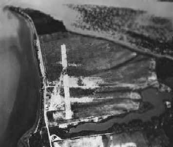
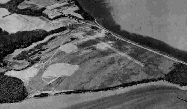
The earliest photo of Hopewell Airport which has been located was a 1936 aerial view, looking north at the field.
It depicted Hopewell Airport as having a single north/south runway.
An aerial view of Hopewell Airfield from the Airport Directory Company's 1937 Airports Directory (courtesy of Bob Rambo).
The directory described Hopewell Airport as having a single 2,000' gravel northeast/southwest runway, and a seaplane ramp adjoining the airport.
The first airmail was flown from Hopewell on 5/20/38, according to the book "Virginia Airports".
During WW2 an airplane factory was reportedly built at Hopewell Airport (by whom, and for what type of aircraft?),
but was abandoned as the war ended, according to the book "Virginia Airports".
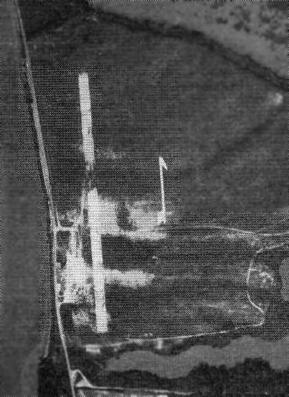
A circa 1942-45 aerial view looking southwest at Hopewell Airport from the 1945 AAF Airfield Directory (courtesy of Scott Murdock)
depicted the field as having several grass runways.
In 1944, the airport was purchased by the city from Herbert Powell.
Hopewell was depicted as a commercial or municipal airport on the April 1945 Norfolk Sectional Chart (courtesy of Chris Kennedy).
The 1945 AAF Airfield Directory (courtesy of Scott Murdock) described Hopewell Airport
as a 194 acre irregularly-shaped property within which were 3 sod runways, the longest being a 2,400' northwest/southeast strip.
The field was said to have a single 66' x 60' wood & steel hangar, to be owned by the City of Hopewell, and to be privately operated.
The July 1953 Chesapeake Bay USAF World Aeronautical Chart (courtesy of Chris Kennedy)
depicted Hopewell as having a 2,800' hard surface runway.
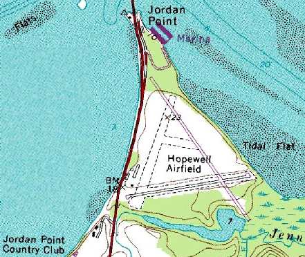
The 1953 USGS topo map depicted Hopewell Airfield
as having a single northeast/southwest runway & several buildings & a seaplane ramp along the west side.
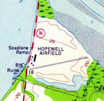
Hopewell Airfield was depicted on the 1960 USGS topo map with a single east/west runway,
a single hangar at the west end of the runway,
and a seaplane ramp on the opposite side of Route 156.
The 1961 Norfolk Sectional Chart (courtesy of Chris Kennedy)
depicted Hopewell as having a 2,400' paved runway, oriented northeast/southwest,
as well as an adjacent seaplane base.
A 3/30/63 USGS aerial view depicted Hopewell Airport as having an asphalt northeast/southwest runway & 2 grass runways.
Two light single-engine aircraft were parked near a few small hangars on the southwest side.
The Aerodromes table on the 1965 Norfolk Sectional Chart (courtesy of John Voss)
described the field as having three runways, with the primary being a 2,418' asphalt strip.
The only runway depicted on the chart itself was the east/west runway.
In 1968, Hopewell Airport was operated by Dr. Daugherty & Jay Ipson.
Don Cummins was an instructor at Hopewell, and he had a 7AC Champ on floats on the river.
Hopewell was depicted as an active airfield on the 1970 Washington Sectional Chart (courtesy of John Clifford),
with two paved runways (the longest being 3,500').
The 1970 VA Airport Directory (courtesy of Stephen Mahaley) described Hopewell Airport
as having two paved runways (with the longest being the 3,500' Runway 15/33) and 2 turf runways.
Two hangars, a shop, and an office were depicted along the west side of the field, and the Hopewell Seaplane Base was depicted on the opposite side of the road.
The airport was said to offer flight instruction, charter, and maintenance.
It listed the operator as Americana Aviation, and the manager was listed as J. M. Ipson.
William Drumright recalled, "In the 1972-74 time frame, I flew with the Civil Air Patrol Squadron based in Hopewell.
For most of that period, we used the Hopewell Airfield.
It was from this field that we made at least one flight up to the State Police field on the outskirts of Richmond.
That flight was part of a training exercise with the scenario being that we were to land,
pickup some urgently needed blood in containers, and fly them to the desired location.
Our flight was conducted in a former Air Force L-19."
A 9/8/73 aerial view by Kenneth Keeton looking southeast at Hopewell Airport.
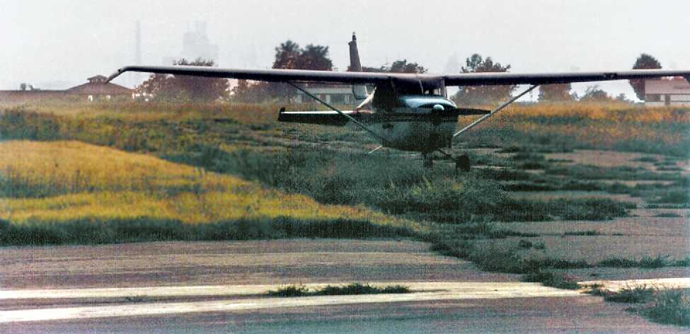
An undated photo by Kenneth Keeton of his 1962 Cessna 172C N8249X at Hopewell Airport.
Hopewell Airport, as depicted on the 1975 Washington Sectional Chart (courtesy of Ed Drury).
The last aeronautical chart depiction which has been located of Hopewell Airport was on the March 1981 Washington Sectional Chart (courtesy of Ron Plante).
It depicted Hopewell Airport as having 2 paved runways, with the longest being 3,300'.
Hopewell was described in the 1982 AOPA Airport Directory (courtesy of Ed Drury)
as having two asphalt runways: 3,345' Runway 15/33 & 2,405' Runway 8/26.
According to the book "Virginia Airports", a 1982 article described how the Hopewell Airport
would be used as an ultralight flight park, "Virginia Wings Ultra Flight Park".
It was planned to be open to the public in 1983,
but it has not been determined if these plans were ever realized.
William Drumright recalled, "The last time I was at the Hopewell Airport was just after it had been declared closed
and the construction was beginning on the subdivision which replaced it.
The old hangar was still standing & it was being used for a rather unusual event.
There was a small circus in town, but the weather was wet & windy
and led to cancellation of all but the 'Main Attraction'.
The Main Attraction was the performer named 'Tiny Tim' of ukulele & the Johnny Carson Tonight Show fame.
It was cold & windy inside the hangar, but his show did happen."
Hopewell Airport was apparently closed prior to 1989,
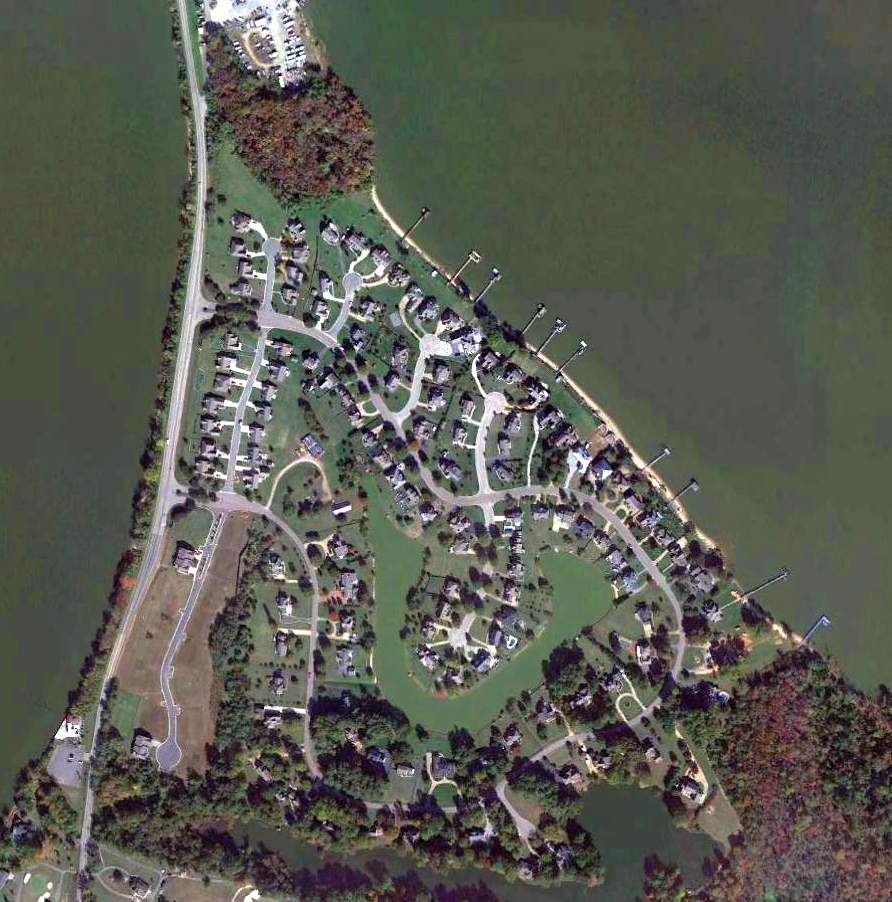
as a 1989 aerial photo showed that the property had been redeveloped as a housing development, Jordan on the James,
with not a trace remaining of the former airport.
Hopewell Airport was no longer depicted at all (not even as an abandoned airfield)
on the 1991 Washington Sectional Chart (courtesy of Mike Keefe).
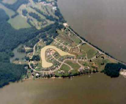
A 1995 aerial view looking southwest at the site of Hopewell Airport
showed that the property had been redeveloped as a housing development,
with not a trace remaining of the former airport.
This is a perfect example of why you can’t always trust maps - this is the USGS topo map from 1996.
The 1996 map still depicted the Hopewell Airfield,
even though pictures from 2 years prior showed that it had already been replaced by a housing development.
A 10/21/12 aerial photo showed that no trace of Hopewell Airport remains.
The site of Hopewell Airfield is located east of Route 156, along the south bank of the James River.
____________________________________________________
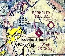
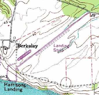
Berkeley Field (7W5), Charles City, VA
37.318, -77.172 (Southeast of Richmond, VA)
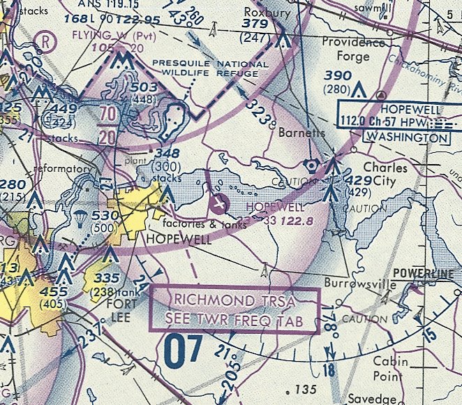
Berkeley Field, as depicted on the 1970 Washington Sectional Chart.
This small airfield on the north shore of the James River was evidently established at some point between 1965-70,
as it was not yet depicted on a 1963 aerial photo, the Septemer 1966 Norfolk Sectional Chart, or the 1967 USGS topo map.
It sits adjacent to Berkeley Plantation, the birthplace of President William Harrison.
The earliest depiction which has been located of Berkeley Field was on the 1970 Washington Sectional Chart.
It depicted Berkley as having a 3,200' unpaved runway.
Ron Plante recalled that Berkeley Field was "where I learned to fly in 1970-71 while stationed at Ft Lee.
It was a grass strip with Runway 6/24.
Jay Ipson owned Americana Aviation, which had a trailer & gas pumps.
I flew both Cessna 150s & the 172 but not the high-performance single (Mooney?)."
Richard Anderson recalled, “I learned to fly there in June 1972 with a dozen other Civil Air Patrol cadets
who attended the 1972 Virginia Wing Cadet Solo Encampment.
We lived in the barracks at Ft. Lee for 2 weeks
and were bused back & forth to Berkeley Plantation Airport (in fact, I was the bus driver at the ripe old age of 17!).
We had a huge graduation ceremony on 7/1/72 at the southwest corner of the runway
at a memorial erected by the American Legion in commemoration of the writing of the song 'Taps' on the very site of the airport.
The airport was operated by Jay Ipson, who is the same Jay Ipson who ran Americana Aviation at the Hopewell Airport.
He was the Cadet Solo Encampment commander in 1972 when I learned to fly.”
The 1972 USGS topo map ironically depicted Berkley Field with the symbol of a 4-engine swept-wing airplane -
not very appropriate for a tiny grass-runway airfield.
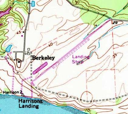
The 1974 USGS topo map depicted Berkeley Field as a single unpaved northeast/southwest runway, labeled simply as "Landing Strip".
Berkeley Field, as depicted on the 1975 Washington Sectional Chart (courtesy of Ed Drury).
The 1975 USGS topo map depicted Berkeley Field as having a single unpaved northeast/southwest runway, labeled simply as “Landing Strip”.
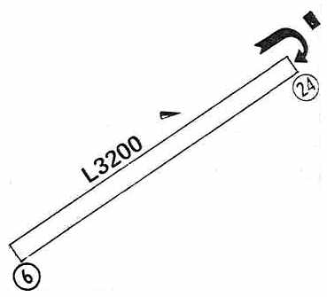
"Berkeley Plantation" Airport was depicted in the 1979 Flight Guide (courtesy of Chris Kennedy)
as having a single 3,200' unpaved Runway 6/24,
with a single building at the northeast corner of the field.
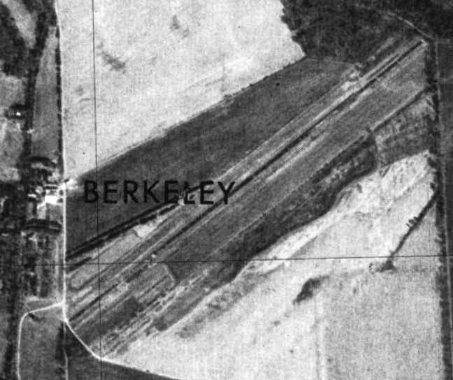
The earliest photo which has been located of Berkeley Field was a 3/13/79 USGS aerial view.
It depicted Berkeley as having a single northeast/southwest grass runway.
"Berkeley Plantation" Airfield was listed in the 1982 AOPA Airports USA Directory (courtesy of Ed Drury),
and was described as having a single 3,200' turf Runway 6/24.
The single runway of Berkeley Field was still depicted on the 1984 USGS topo map,
but it was labeled merely as "Landing Strip",
which most likely means that the airfield was closed by that point.
Berkeley Field was definitely closed by 1991,
as it was no longer depicted at all on the 1991 Washington Sectional Chart (courtesy of Mike Keefe).
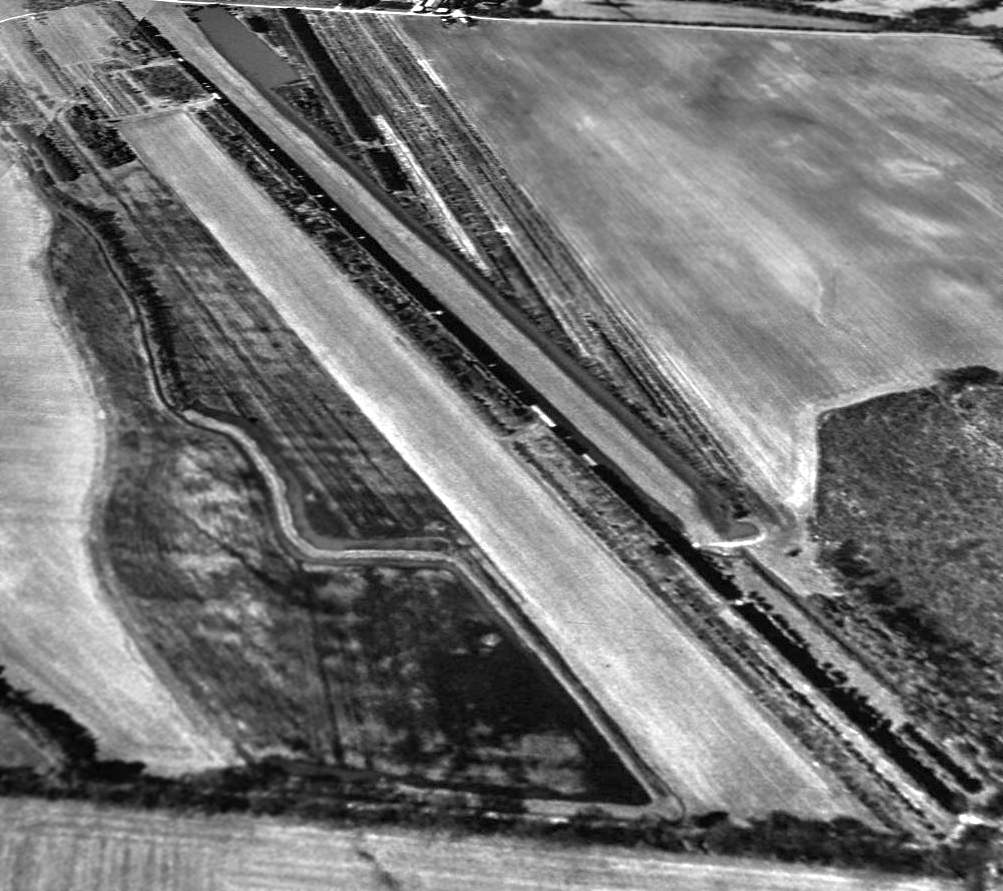
A 3/11/94 USGS aerial view looking west depicted Berkeley's single grass runway as remaining intact & in serviceable condition,
but there did appear to be any buildings, aircraft, or sign of any recent usage.
The single runway of Berkeley Field was still depicted on the 1996 USGS topo map,
but it was labeled merely as "Landing Strip".
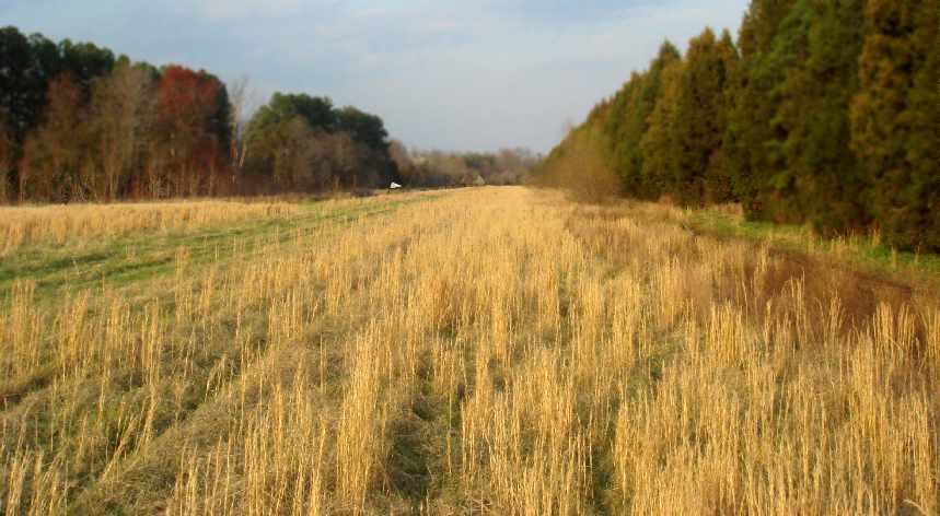
A 2007 photo by Richard Anderson looking northeast along Berkeley's former Runway 6.
Richard reported, “On 3/23/07 I drove to Berkeley Plantation Airport & walked the runway for the first time in 35 years.
The runway is now overgrown with a foot of grass & tall trees now encroach along both sides of the runway.
In an emergency, an airplane could probably land there to this day.
My walk down that runway late on the afternoon of 3/23/07, just before dark & all alone,
made me long for a simpler day in the life of general aviation in America.
The memories were thick as flies & would have been impossible to brush away.”
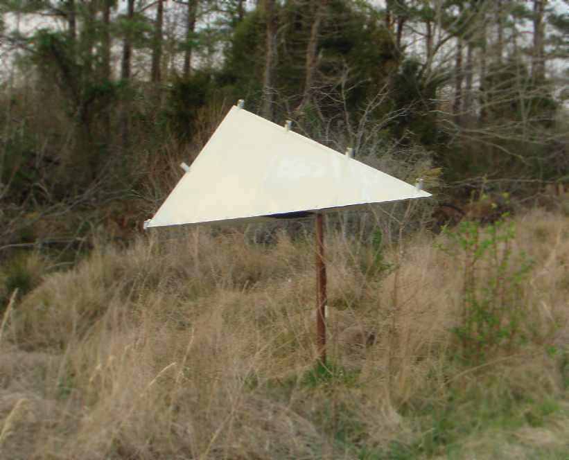
A 2007 photo by Richard Anderson, who observed, “Amazingly, the wind T still stands halfway down the runway & freely swings on its stand.”
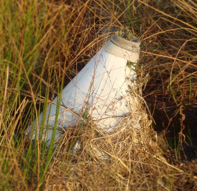
A 2007 photo by Richard Anderson, who observed, “Remnants of the runway lighting cones still exist in shallow standing water along the runway edge
and are almost covered by tall grass.”
A 10/21/12 aerial view looking west showed Berkeley's single grass runway appeared to remain intact & in serviceable condition.
A 2022 photo looking southeast shows Berkeley Field remains clear.
The site of Berkeley Airport is located at the southern end of Harrison Landing Road (where it ends at the James River).
____________________________________________________
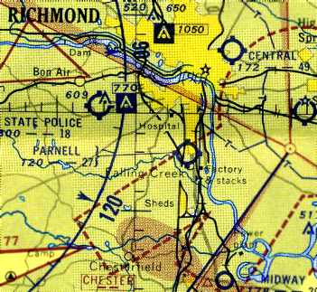
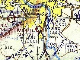
37.47, -77.454 (South of Downtown Richmond, VA)
Parnell Airport, as depicted on the April 1947 Norfolk Sectional Chart.
According to the Richmond Times-Dispatch, Parnell Airport opened in March of 1946.
According to an undated [presumably 1946] newspaper article in the VAHS collection (courtesy of Lyle Browning),
“A former beautician & a prominent lawyer, both of whom were bitten by the aviation bug are now partners in Sky Service Corp.,
and operators of Parnell Airfield at Stop 12 on the Petersburg Pike.
Thurmond (Herman) Hedgepeth is the ex-beautician & Pinckney Sowers is rapidly becoming known around legal circles in Richmond as the 'Flying Lawyer'.
Sowers & the late Clarence Parnell were partners in an aviation venture at Midway Field near Chester in 1941.
Parnell Airfield is located 3 blocks to the right of the Petersburg Pike, going toward Petersburg.
It was opened in May & has 2 runways: 2,800' northwest/southeast & 1,500' east/west.
The field was zoned by the Chesterfield Board of Supervisors as a permanent airport.
At the present there is 1 large cinderblock hangar, office & a pilot lounge.
Six more private hangars will be erected as soon as materials become available.
Melvin Williams, a former Glenn L. Martin employee who holds a CAA certificate & engine rating, heads the maintenance shop at Parnell.”
Parnell Airport was not yet depicted on the October 1946 Norfolk Sectional Chart.
The earliest depiction which has been located of Parnell Airport was on the April 1947 Norfolk Sectional Chart.
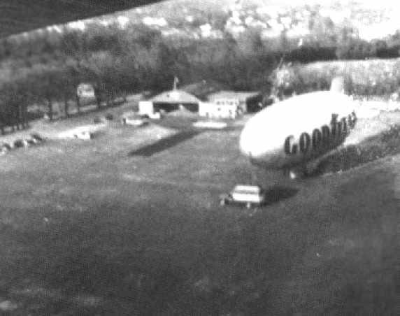
The earliest photo which has been been located of Parnell Airport circa late-1940s aerial view
of a Goodyear blimp moored next to an arch-roof hangar.
According to a 1/2/50 Richmond News Leader article (courtesy of Lyle Browning),
“Parnell Airport... has 85 acres of cleared land, 3 dirt runways, one of which is 2,800' long,
a cinderblock building for pilots & offices, a hangar for the storage of 9 planes & 10 T-hangars.
The business is a joint venture of Pinckney Sowers, an attorney, and Thurmond Hedgepeth.
About 200 students have been taught to fly at Parnell, which also charters flights & services small planes.”
Parnell was later operated by well-known Richmond area aviation personalities Hunter & Sherry Jones,
according to the book "Virginia Airports".
The July 1953 Chesapeake Bay USAF World Aeronautical Chart (courtesy of Chris Kennedy)
depicted Parnell as having a 2,700' unpaved runway.
The July 1954 Norfolk Sectional Chart (courtesy of Chris Kennedy)
depicted Parnell Airport as having a 2,700' unpaved runway.
A 1955 aerial photo depicted Parnell Airport as an irregularly-shaped grass airfield, with 3 hangars & 3 light single-engine aircraft on the northeast side.
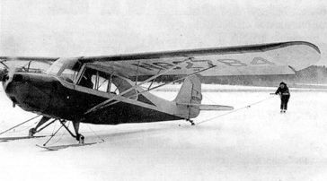
A January 1957 photo of Mrs. Hunter Jones being towed behind a ski-equipped Aeronca which was visiting Parnell Airport.
The earliest topo map depiction which has been located of Parnell Airport was on the 1959 USGS topo map.
It depicted Parnell Airport as an irregularly-shaped property outline, with a few buildings along the northeast side.
Charles Redman recalled, “In 1959 when I was 10 years old, a school buddy & I visited Parnell Airport & played around the perimeter of the field.
One of the mechanics came outside & said, 'Boys, you may stay here in the hangar area or on the outside edges of the field,
but do not under any circumstances walk into or across the field.'”
According to the Richmond Times-Dispatch, at its peak Parnell Airport was home to as many as 30 aircraft.
A series of photos in the book "Virginia Airports" documented how quadriplegic pilot Sammy Gregorio was able to fly a specially modified Ercoupe from Parnell Airport.
He had been instructed by Hunter Jones, who was shown lowering Gregorio into the Ercoupe with the assistance of his wife Sherry Jones.
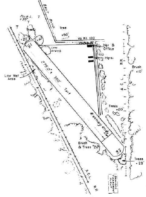
The Aerodromes table on the 1965 Norfolk Sectional Chart (courtesy of John Voss) described Parnell as having a single 2,750' turf runway.
Philip Smith recalled, “I learned to fly from Cherrie Jones at Parnell in the winter of 1966/67.”
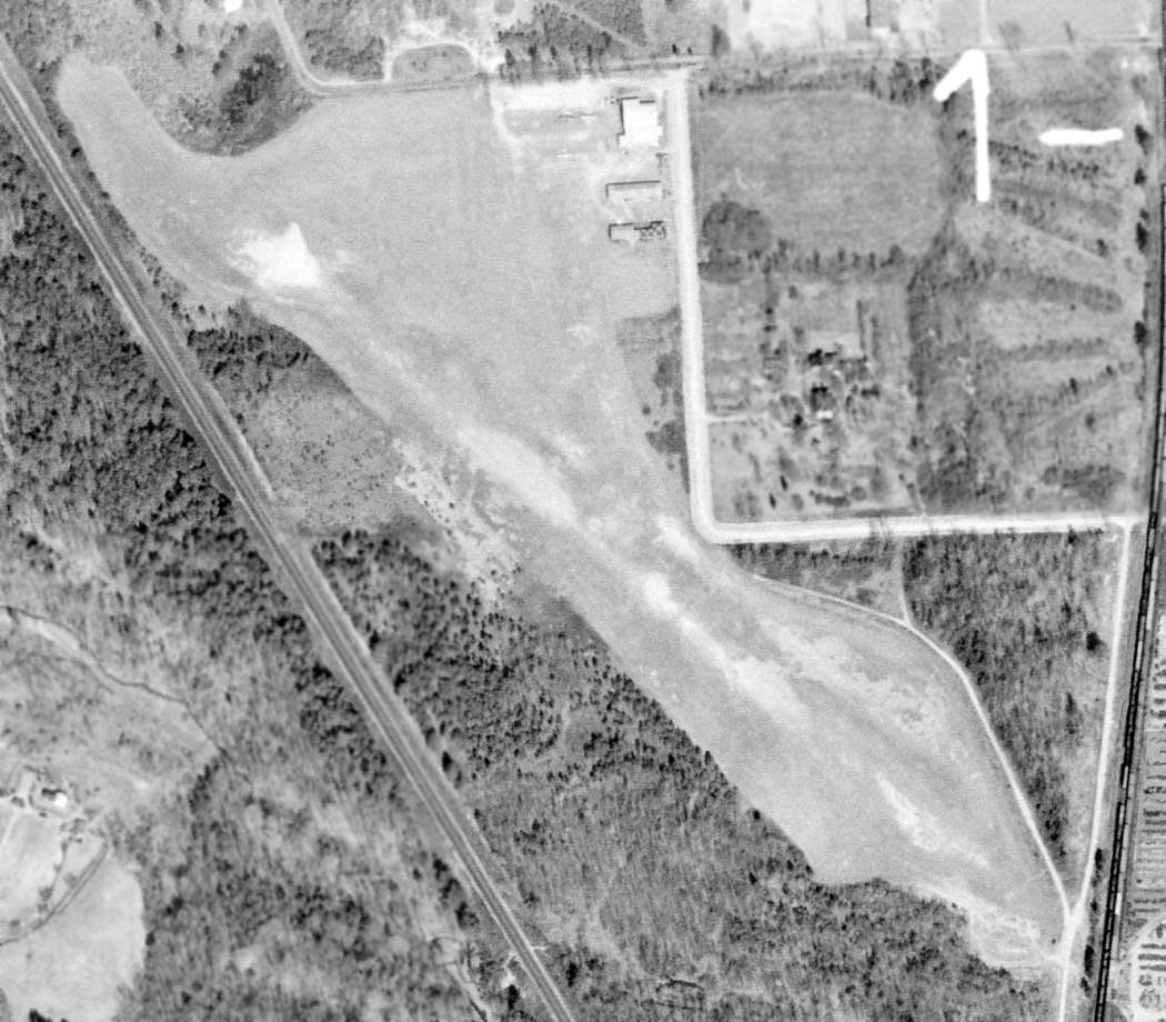
The last photo which has been located showing Parnell Airport in operation was a 2/25/68 USGS aerial view.
It depicted the field as having a single northwest/southeast grass runway, with 3 hangars & 3 light aircraft on the northeast corner.
The 1970 VA Airport Directory (courtesy of Stephen Mahaley)
depicted Parnell Airport as consisting of a single 2,750' turf Runway 15/33.
A hangar & office and another 2 hangars were depicted on the northeast side of the runway.
The field was said to offer flight instruction, charter, and maintenance.
The operator & manager were listed as D. H. Jones.
The 1971 USGS topo map depicted Parnell Airport as having a single unpaved northwest/southeast runway.
Parnell Airport was still depicted as an active airfield
on the 1972 Washington Sectional Chart (courtesy of Mike Keefe).
According to the Richmond Times-Dispatch, Parnell Airport closed in 1972.
The last depiction which has been located of Parnell Airport was in the 1974 Flight Handbook (courtesy of Jonathan Westerling),
even though it had reportedly been closed for 2 years by that point.
Parnell Airport was was no longer depicted on the March 1974 Washington Sectional Chart (courtesy of Jonathan Westerling).
Strangely the 1976 USGS topo map still depicted the title “Parnell Airport”, although it also showed several large buildings having been built over the airport site.
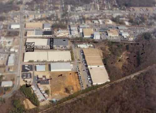
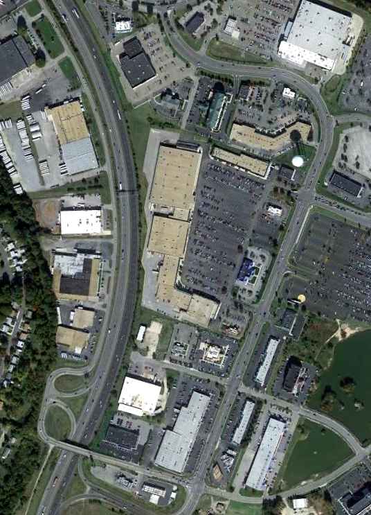
The site of Parnell Airport was covered with several large buildings at some point between 1972-92,
as a 1992 aerial view looking east at the site showed that not a trace appeared to remain of the former airport.
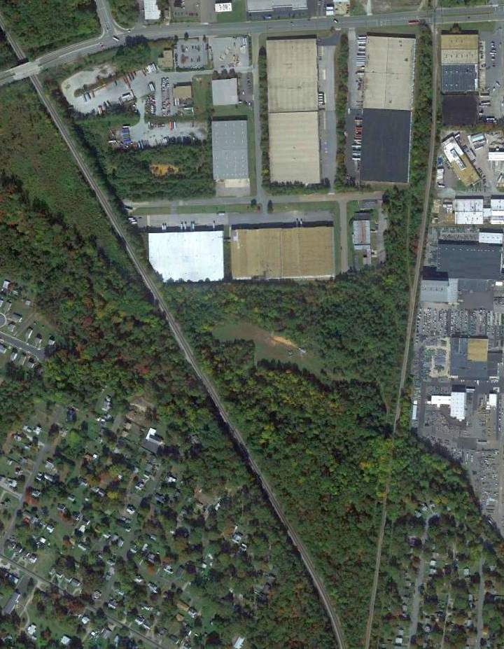
A 10/21/12 aerial photo showed no trace appears to remain of Parnell Airport.
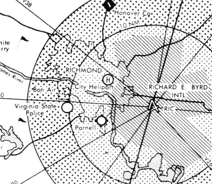
The site of Parnell Airport is located south of the intersection of East Belt Boulevard & Bells Road.
____________________________________________________
Since this site was first put on the web in 1999, its popularity has grown tremendously.
If the total quantity of material on this site is to continue to grow,
it will require ever-increasing funding to pay its expenses.
Therefore, I request financial contributions from site visitors,
to help defray the increasing costs of the site
and ensure that it continues to be available & to grow.
What would you pay for a good aviation magazine, or a good aviation book?
Please consider a donation of an equivalent amount, at the least.
This site is not supported by commercial advertising –
it is purely supported by donations.
If you enjoy the site, and would like to make a financial contribution,
you
may use a credit card via
![]() :
:
Please consider checking the box to make a monthly donatation.
For a mailing address to send a check, please contact me at: paulandterryfreeman@gmail.com
If you enjoy this web site, please support it with a financial contribution.
please contact me at: paulandterryfreeman@gmail.com
If you enjoy this web site, please support it with a financial contribution.
____________________________________________________
This site covers airfields in all 50 states.