Abandoned & Little-Known Airfields:
Texas: Northeastern Corpus Christi area
© 2002, © 2023 by Paul Freeman. Revised 7/25/23.
This site covers airfields in all 50 states: Click here for the site's main menu.
____________________________________________________
Please consider a financial contribution to support the continued growth & operation of this site.
Aloe AAF / Victoria County Airport (revised 7/24/23) - Aloe Aux AAF #10 (revised 5/3/19) - American Liberty Oil Company Airport / Aransas National Wildlife Refuge Airport (revised 5/7/16)
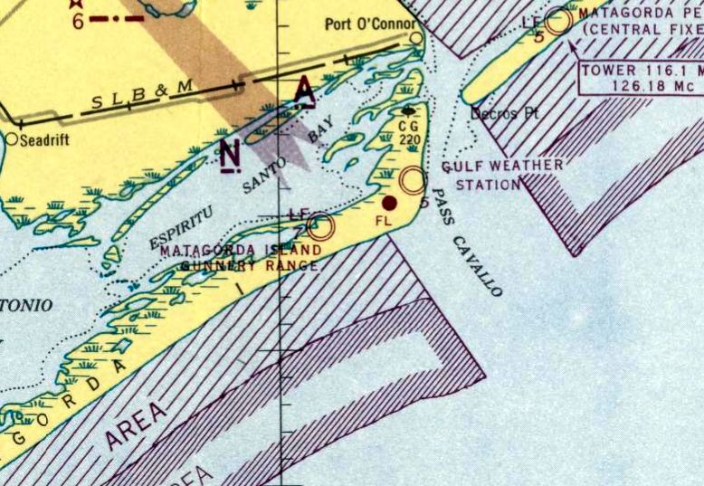
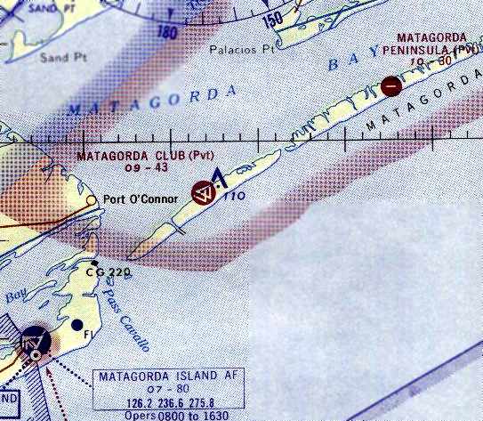
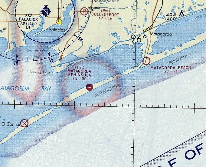
Aransas Pass Municipal (revised 3/4/31) - Barksdale (Gunnery Camp) Army Aux Airfield / Matagorda Peninsula AAF / Matagorda Club Airfield / Pierce Field (revised 7/25/23)
Matagorda Island Gunnery Range AAF / Matagorda Island AFB (revised 7/25/23) - Matagorda Peninsula Airport (revised 3/4/31)
Nursery Field / Foster Aux AAF #4 (revised 5/3/19) - Port Aransas Airport (1st location) (added 1/1/20) - Port Aransas Airport (2nd location) (added 1/1/20)
Victoria Municipal Airport (original location) / Ball Airport (revised 3/4/31) - Worsham Field (revised 3/4/31)
____________________________________________________
Port Aransas Airport (1st location), Port Aransas, TX
27.847, -97.052 (Northeast of Corpus Christi)
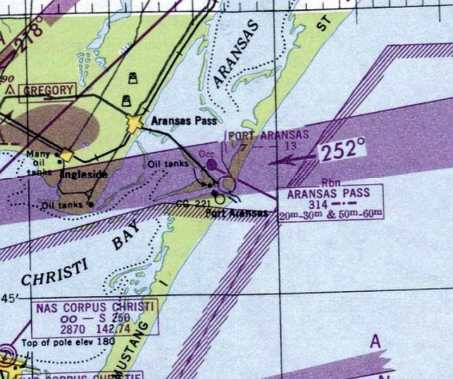
Port Aransas Airport, as depicted on the February 1949 Corpus Christi Sectional Chart.
Photo of the airport has not been located.
The short-lived first location of Port Aransas Airport was on the southwest end of San Jose Island, across the Aransas Channel from the town of Port Aransas.
The first location of Port Aransas Airport was evidently established at some point between 1948-49,
as it was not yet depicted on the July 1948 Corpus Christi Sectional Chart.
The earliest depiction which has been located of Port Aransas Airport was on the February 1949 Corpus Christi Sectional Chart.
It depicted Port Aransas Airport as having a mere 1,300' unpaved runway.
The August 1949 Corpus Christi Sectional Chart depicted Port Aransas Airport in an unchanged fashion.
At some point between 1949-50, Port Aransas Airport was evidently relocated to a 2nd location,
2 NM to the southwest, adjacent to the southwest side of the town of Port Aransas.
That it where it was depicted on the February 1950 Corpus Christi Sectional Chart.
Nothing recognizable as a former airfield was depicted at the 1st location of Port Aransas Airport on a 1951 aerial photo
nor on the 1954 USGS topo map
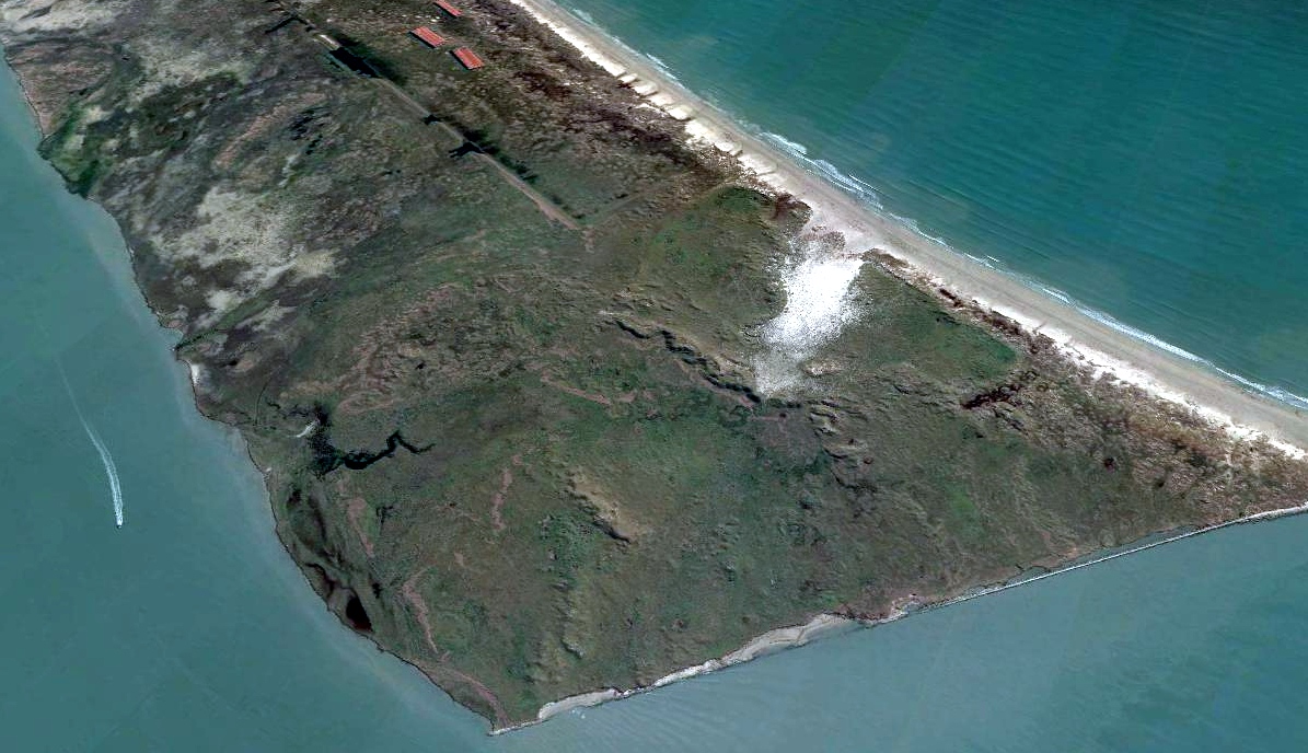
A 2017 aerial view looking northeast at the site of the 1st location of Port Aransas Airport showed no trace of the airfield.
____________________________________________________
Port Aransas Airport (2nd location), Port Aransas, TX
27.828, -97.073 (Northeast of Corpus Christi)
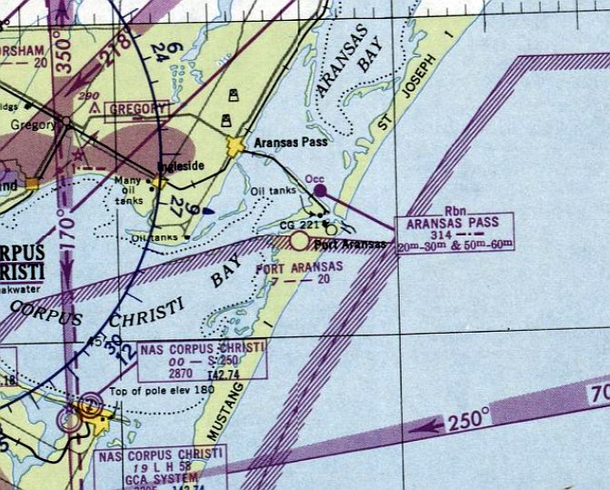
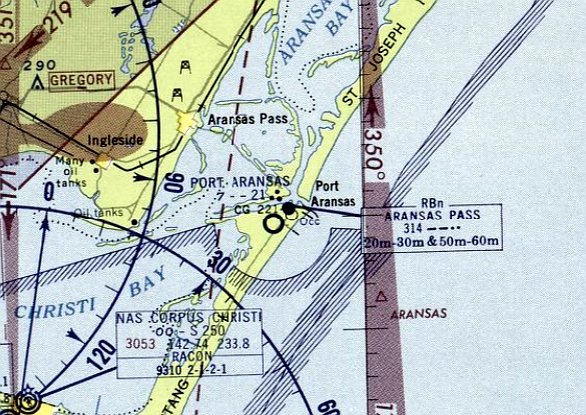
Port Aransas Airport, as depicted on the February 1950 Corpus Christi Sectional Chart.
Photo of the airport while in use has not been located.
At some point between 1949-50, the 1st location of Port Aransas Airport (on the southwest end of San Jose Island)
was evidently replaced by a 2nd location, adjacent to the southwest side of the town of Port Aransas.
That it where it was depicted on the February 1950 Corpus Christi Sectional Chart.
It depicted Port Aransas Airport as having a 2,000' unpaved runway.
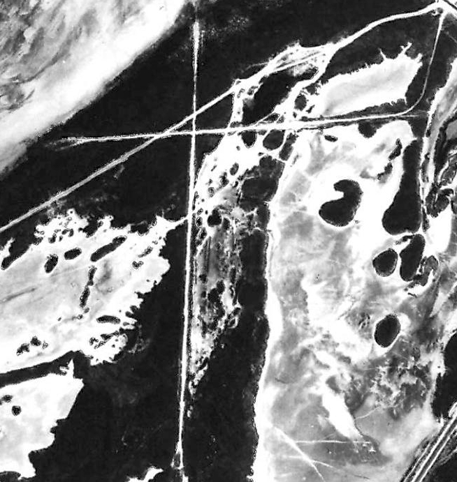
The earliest photo which has been located of Port Aransas Airport was a 1951 USGS aerial view.
It depicted 2 unpaved runways, with water all around, and no buildings or other airport improvements.
There were no aircraft visible on the field.
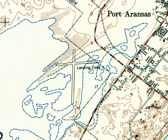
The 1954 USGS topo map depicted the Port Aransas Airport as having 2 runways, labeled generically as “Landing Field”.
There were no buildings or other airport improvements depicted.
The earliest photo which is available of Port Aransas Airport was a 1955 TX General Land Office aerial view.
It depicted 2 unpaved runways, with water all around, and no buildings or other airport improvements.
There were no aircraft visible on the field.
The last aeronautical chart depiction which has been located of Port Aransas Airport was on the August 1957 Corpus Christi Sectional Chart.
It depicted Port Aransas Airport as having a 2,100' unpaved runway.
Port Aransas Airport was evidently abandoned (for reasons unknown) at some point between 1957-58,
as it was no longer depicted on the February 1958 Corpus Christi Sectional Chart.
In 1965, Mustang Beach Airport was established a mile to the southwest of the site of Port Aransas Airport.
A 1967 USGS aerial photo of the site of Port Aransas Airport showed the north/south runway was still intact,
but the east/west runway was deteriorated & eroded.
A 1979 TX General Land Office aerial view of the site of Port Aransas Airport showed the north/south runway was still intact,
but the east/west runway was deteriorated & eroded.
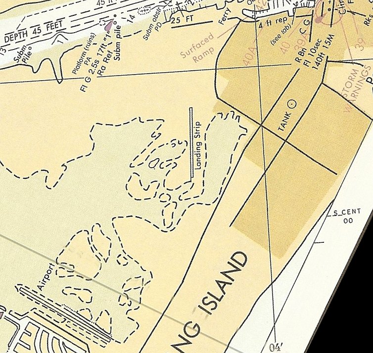
A 1987 nautical chart (courtesy of Bill Hoglan) depicted 1 north/south runway at the location of the former Port Aransas Airport, labeled generically as “Landing Strip”.
Note that it also depicted Mustang Beach Airport a mile to the southwest, labeled as “Airport”.
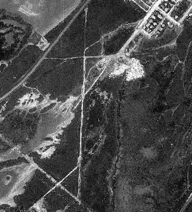
A 1995 aerial photo showed no trace of Port Aransas Airport, with streets & houses having been built over the northern portion.
A 2017 aerial view of the site of the 2nd location of Port Aransas Airport showed streets & houses over the northern portion,
and the faintest trace still recognizable of the north/south runway.
The site of the 2nd location of Port Aransas Airport is located at the southwestern terminus of 6th Street.
Thanks to Bill Hoglan for pointing out this airfield.
____________________________________________________
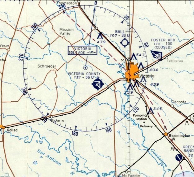
(Original) Victoria Municipal Airport / Ball Airport, Victoria, TX
28.12, -96.8 (Northeast of Corpus Christi)
The original Victoria Municipal Airport, as depicted on the March 1940 San Antonio Sectional Chart.
The original airport for the town of Victoria was located northwest of the town.
No airfield was depicted at this location on the 1934 San Antonio Sectional Chart.
According to Lester Giese, “Ball Airport... originated about 1937.
It was owned & operated by Warren Ball. It was a grass landing field.”
No airfield was depicted at this location on the June 1939 San Antonio Sectional Chart.
The earliest depiction which has been located of this field was on the March 1940 San Antonio Sectional Chart.
It depicted Victoria Airport as a commercial/municipal airport.
The 1945 AAF Airfield Directory (courtesy of Scott Murdock) described Victoria Municipal Airport as a 148 acre irregularly-shaped property
having 3 sod, sand, and loam runways, the longest measuring 2,500' north/south.
A single 83' x 35' wood hangar was depicted along with some other small buildings on the east side.
The field was said to be owned & operated by private interests.
The July 1945 San Antonio Sectional Chart depicted the original Victoria Municipal Airport as a commercial/municipal airport.
According to an obituary, in the late 1940s “Joe [Canion] crop-dusted for Warren Ball at Ball Airport.”
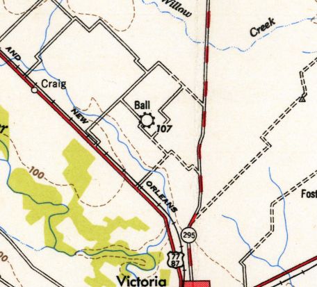
The 1953 USGS topo map shows the airport having been renamed Ball Airport,
after the much larger Foster AAF to the east of the town was vacated by the military & reused as the new Victoria Airport.
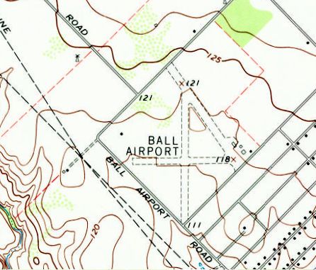
The 1963 USGS topo map shows Ball Airport to have 3 unpaved runways, with a few small buildings on the east side.
An 11/11/79 aerial photo shows Ball Airport to have 3 unpaved runways, with a few small buildings on the east side.
According to Lester Giese, “Ball Airport... was operated after his [Warren Ball's 1993] death by his daughter Dolores Ball Kenne & her husband.”
The only photo which has been located showing aircraft at Ball Airport was a 1995 aerial view looking northwest,
which showed 2 or 3 light single-engine aircraft parked on the east side.
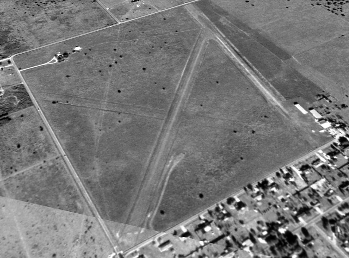
A 2005 aerial view showed the Ball Airport property remained intact, but the runways were somewhat less distinct,
and there were no aircraft visible on the field.
According to Lester Giese, “Ball Airport... closed in 2007.”
A 2008 aerial view showed no change at the site of Ball Airport.
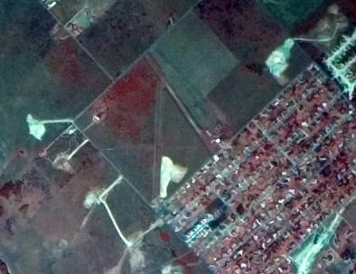
A 2009 aerial view showed that a large building had been constructed over the west side of Ball Airport,
but the 3 hangars remained intact on the east side.
A 2011 aerial view showed that a street had been constructed over the southern portion of the Ball Airport site.
A 2013 aerial view looking northwest at the site of Ball Airport showed the southern portion had been covered with houses,
but amazingly traces were still recognizable of 2 runways at the northern end of the property,
and 1 former hangar remained standing on the east corner of the airport site.
The site of Ball Airport is located north of the intersection of Malette Drive & Ball Airport Road, appropriately enough.
Thanks to Lester Giese for pointing out this airfield.
____________________________________________________
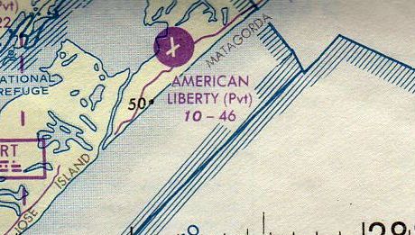
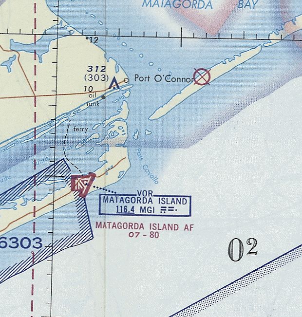
American Liberty Oil Company Airport / Aransas National Wildlife Refuge Airport (XS10), Matagorda Island, TX
28.12, -96.8 (Northeast of Corpus Christi)
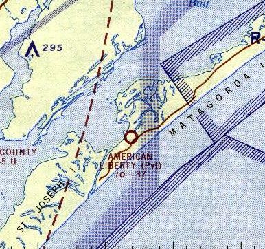
American Liberty Oil Company Airport, as depicted on the 1964 San Antonio Sectional Chart.
The date of establishment of this airfield has not been determined.
According to Bill Hedrick, “Even FDR landed there & visited during WWII.”
However, this airfield was not yet depicted on the 1960 USGS topo map
or the February 1961 San Antonio Sectional Chart.
The earliest depiction which has been located of the American Liberty Oil Company Airport
was on the 1964 San Antonio Sectional Chart.
It depicted American Liberty as a private airfield with a 3,700' unpaved runway.
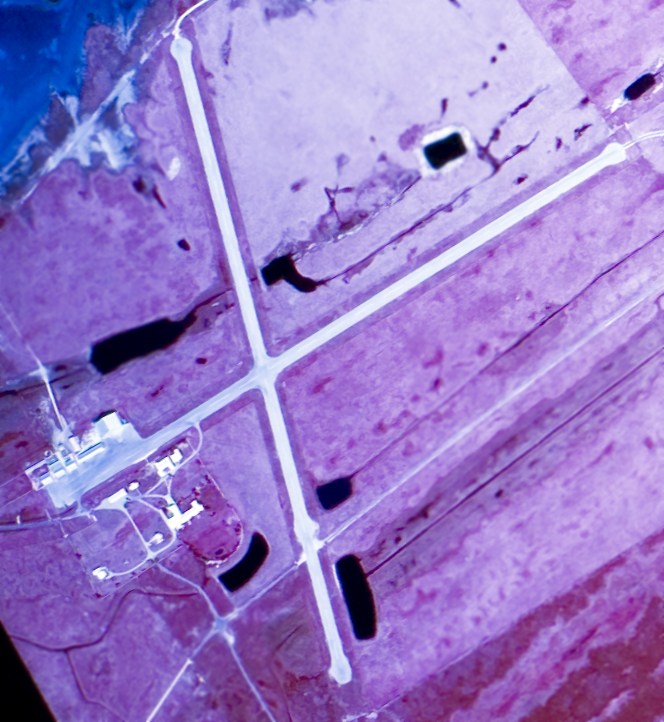
The earliest photo which has been located of the American Liberty Oil Company Airport was on a 10/1/72 USGS aerial view,
which depicted the field as having 2 paved runways & a ramp & a cluster of buildings on the west side.
The airfield had presumably been built as a retreat/resort for the oil company.
The 1973 USGS topo map depicted the American Liberty Oil Company Airport as having 2 paved runways, with a ramp & several buildings on the west side.
The last aeronautical chart depiction which has been located of the American Liberty Oil Company Airport
was on the 1976 Brownsville Sectional Chart (courtesy of Jim Hackman).
It depicted American Liberty as a private airfield having 2 paved runways, with the longest being 4,600'.
According to Bill Hedrick, “In 1981, David Hannah II, the Houston real estate developer who organized Space Services, Inc.,
got with one of his major investors, Toddie Lee Wynne (owner of American Liberty Oil)
and Wynne agreed to have the operation moved to his estate at the western (southwestern) end of Matagorda Island, about 34 miles down the coast.
The Percheron rocket exploded on the launch pad during an engine test in 1981 (on Wynne estate, Matagorda Island) and the company regrouped with another plan.
Wynne had his own airport (now referred to as Aransas National Wildlife Refuge Airport) at his estate,
complete with a luxurious Convair (had DC-3 before that) and this airport was used to bring in people & supplies to the estate, which was quite luxurious.
In 1982, it was a busy airport with scores of planes & helicopters landing there.
Deke Slayton would also fly his own Cessna there & was known to put on a show at times... much to the chagrin of FAA officials onsite at the time.
There was also a boat port there at the estate connecting with Rockport, Texas.”
Bill continued, “The remains of the Percheron pad are located about 3.98 miles northeast of the center of the existing runway(s) up the road that runs the length of the island.
The platform is on the north side of the road & there is a small (square) pond opposite it on the south side of that road.
After the explosion, Space Services & Gary Hudson parted ways & SSI hired Deke Slayton, former astronaut, to head the program.
They decided to go with a solid-fueled rocket this time (Percheron was liquid-fueled) and successfully launched Conestoga I the next year in 1982 from a different site.
This new pad was the opposite direction from the runway, a little over 3 miles southwest of the runway.
There are actually 2 visible ruins there... one is the ruins of the rocket assembly building (2.8 miles from runway) and the other is the concrete pad itself (3.98 miles).
Both are visible on [aerial photos].”
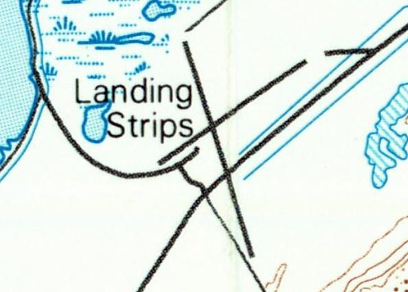
The 1983 USGS topo map still depicted American Liberty as having 2 paved runways,
but it was labeled generically as “Landing Strips”, which may indicate that the airport was closed by that point.
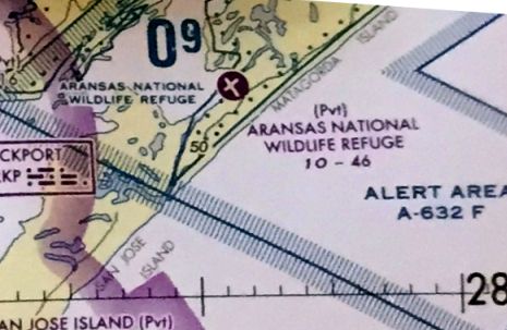
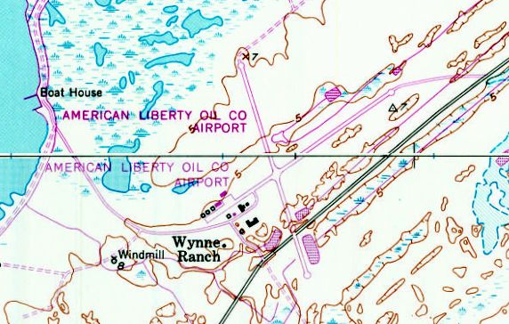
At some point between 1983-2009 the airfield was evidently renamed as the Aransas National Wildlife Refuge Airfield,
as that is how it was labeled on the 2009 Brownsville Sectional Chart.
It was depicted as having 2 paved runways, with the longest being 4,600'.
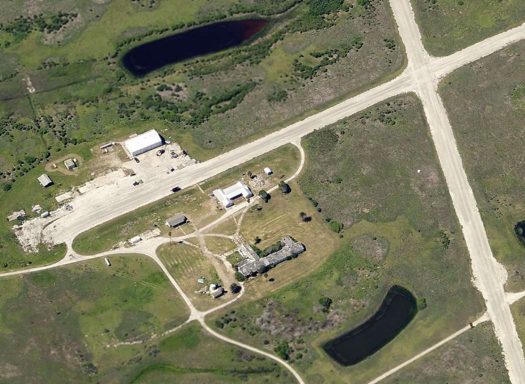
A circa 2010 aerial view looking north at the hangar & other buildings on the west side of the Aransas National Wildlife Refuge Airfield.
A 2013 aerial view looking northeast at the Aransas National Wildlife Refuge Airfield
showed the runways & buildings to remain intact, though deteriorated.
As of 2014, road maps showed the Aransas National Wildlife Refuge Airfield to be within the bounds of the Matagorda Island Wildlife Refuge.
The Aransas National Wildlife Refuge Airport was evidently closed at some point between 2009-2014,
as 2014 aeronautical charts depicted it as an abandoned airfield.
Bill Hedrick reported in 2015, “Matagorda Island is now federal land under the US Fish & Wildlife Department & a special permit to visit the island is required & access is by boat only.
They do NOT allow landings at the old Wynne airport.”
____________________________________________________
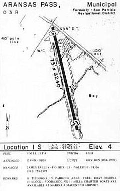
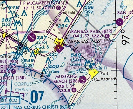
Aransas Pass Municipal Airport (O3R), Aransas Pass, TX
27.886, -97.15 (Northeast of Corpus Christi)
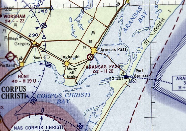
Aransas Pass Municipal Airport, as depicted on the February 1965 Corpus Christi Sectional Chart.
This general aviation airport was evidently built at some point between 1960-63,
as it was not yet depicted on a 1955 USGS aerial photo, and a 1960 aerial photo showed the beginnings of construction of the runway.
Aransas Pass Municipal Airport was not yet depicted on the February 1961 Corpus Christi Sectional Chart.
The earliest reference which has been located of Aransas Pass Airport was in the 1963 TX Airport Directory,
which described the field as having a 2,000' hard-surface runway.
The manager was listed as Paul Lomax, of the First State Bank.
The earliest depiction which has been located of Aransas Pass Airport was on the February 1965 Corpus Christi Sectional Chart.
It depicted Aransas Pass Airport as having a 2,000' paved runway.
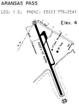
By 1970, the Aransas Pass runway had been slightly lengthened, as the 1970 TX Airport Directory (courtesy of Ray Brindle)
depicted Aransas Pass as having a 3,200' asphalt Runway 15/33, as well as a parallel taxiway & a ramp area on the northeast side of the runway.

The 1975 USGS topo map depicted Aransas Pass Municipal Airport as having a single northwest/southeast paved runway, with a taxiway & ramp on the northeast side.
The July 1979 Brownsville Sectional Chart (courtesy of Jim Hackman)
depicted Aransas Pass Municipal Airport as having a single northwest/southeast paved 3,300' runway.
The only photo which has been located showing aircraft on Aransas Pass Municipal Airport was a 3/5/85 aerial view looking southwest.
Three light aircraft were visible on the ramp on the northeast side of the field.
The 1985 TX Airport Directory (courtesy of Steve Cruse) depicted the runway configuration as basically unchanged.
The last aeronautical chart depiction which has been located of Aransas Pass Municipal Airport
was on the June 1993 Brownsville Sectional Chart (courtesy of Ron Plante).
It depicted Aransas Pass Municipal Airport as having a single northwest/southeast paved 3,200' runway.
According to local pilot Jeffery Sternberg, Aransas Pass Airport was still an active municipal airport up to 1996.
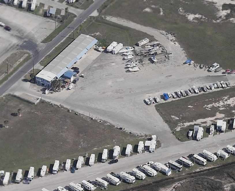
It was closed sometime after that, and the runway is now completely lined with trailer homes.
Aransas Pass was depicted as an abandoned airfield on the 1998 World Aeronautical Chart.
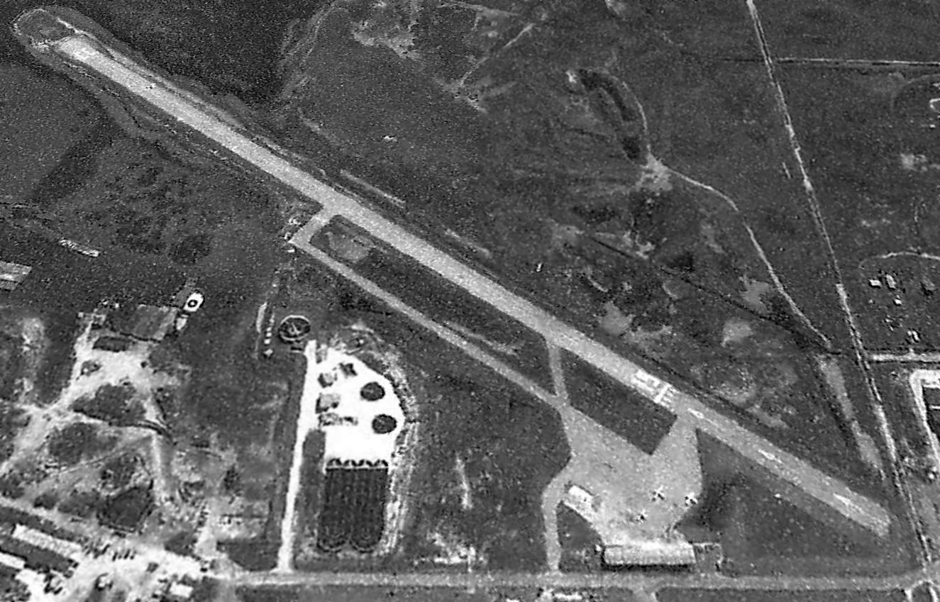
A circa 2001-2005 aerial view looking east at the former terminal building / hangar on the ramp of the former Aransas Pass Airport.
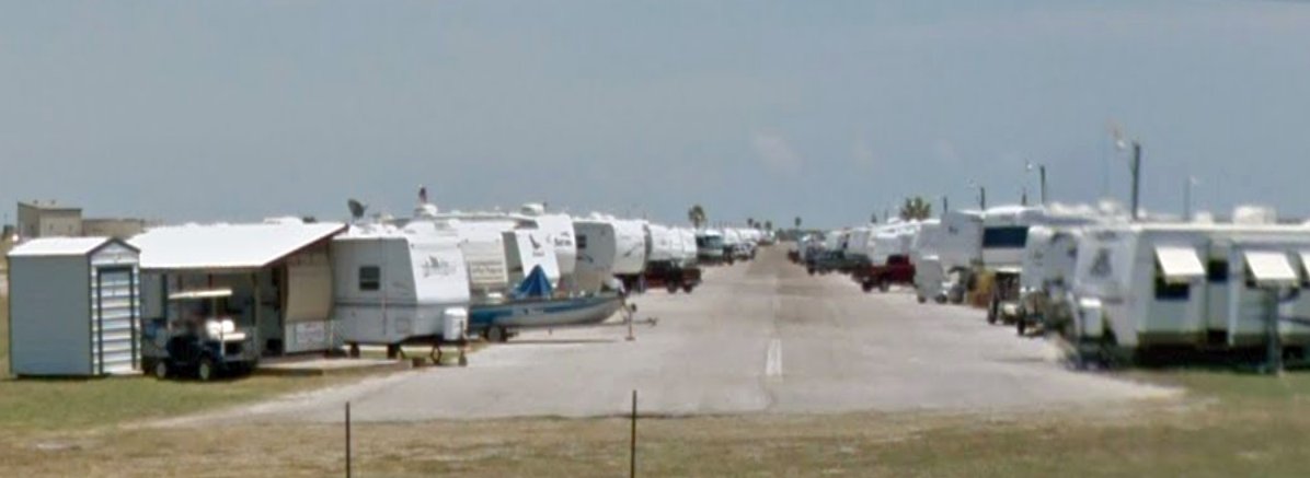
A July 2011 photo looking southeast along the former Aransas Pass Airport Runway 15, now filled with recreational vehicles.
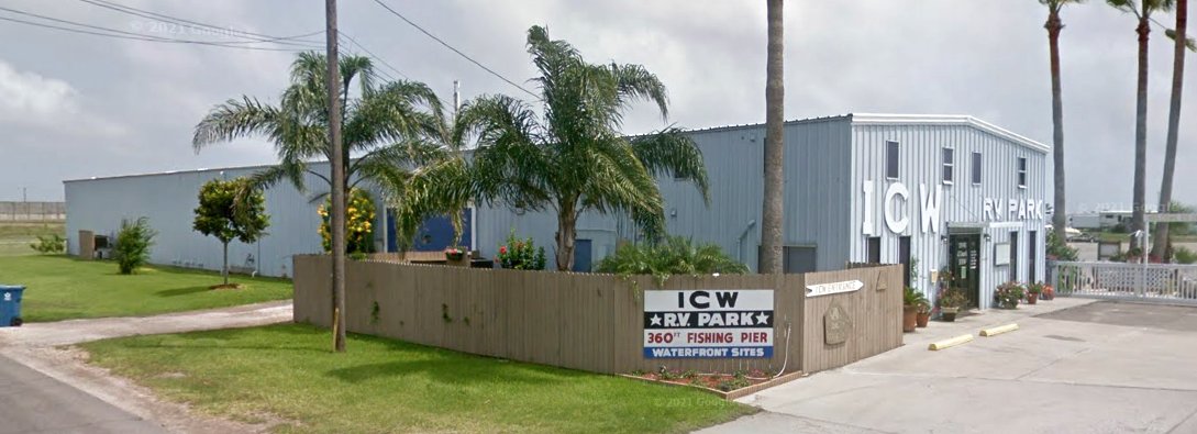
A May 2016 photo looking south at the former Aransas Pass Airport terminal building / hangar, now reused by the ICW Recreational Vehicle Park.
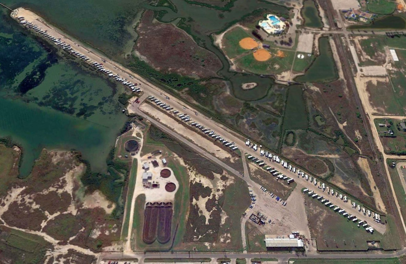
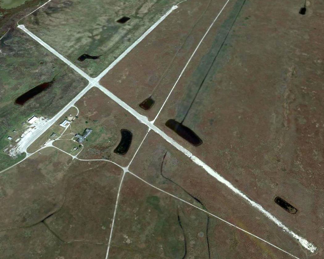
A 2017 aerial view looking southwest at the former Aransas Pass Airport showed the runway remained completely intact, lined with trailers.
____________________________________________________
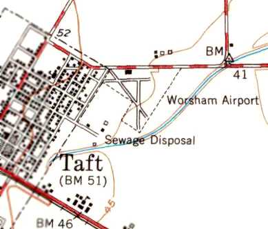
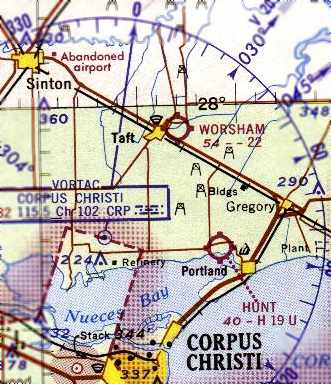
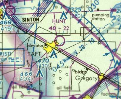
Worsham Field / Hunt Dusting Service Field (90R), Taft, TX
27.98, -97.38 (Northeast of Corpus Christi, TX)
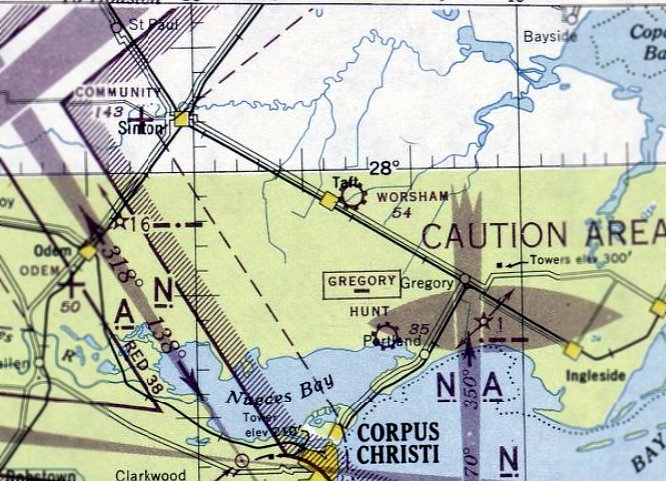
Worsham Field, as depicted on the July 1945 Corpus Christi Sectional Chart.
This small general aviation airport was evidently established at some point in 1945
(like hundreds of other small airports in the American post-WW2 aviation boom),
as it was not yet depicted on the January 1945 Corpus Christi Sectional Chart.
The earliest depiction of Worsham Field which has been located was on the July 1945 Corpus Christi Sectional Chart.
Michael Morgan recalled “the old Worsham Field in Taft... I lived in Taft 1946-54 & it was quite active.
Aeronca sales, flight training, and a sizable crop dusting operation.”
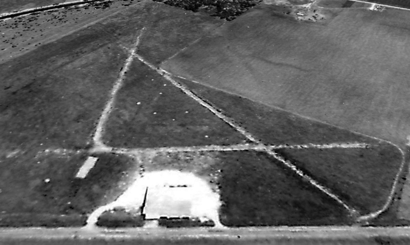
The earliest photo which has been located of Worsham Airport was a 1949 TX General Land Office aerial view looking south.
It depicted the field as having 3 unpaved runways, with a hangar on the north side.
No aircraft were visible on the field.
The 1951 USGS topo map depicted Worsham Airport as having 3 runways, with a hangar on the north side.
A 1961 aerial view depicted Worsham Airport in an unchanged manner, but with one single-engine aircraft visible near the hangar.
The Aerodromes table on the 1964 Corpus Christi Sectional Chart described Worsham as having 3 unpaved runways,
with the longest being a 2,200' turf strip.
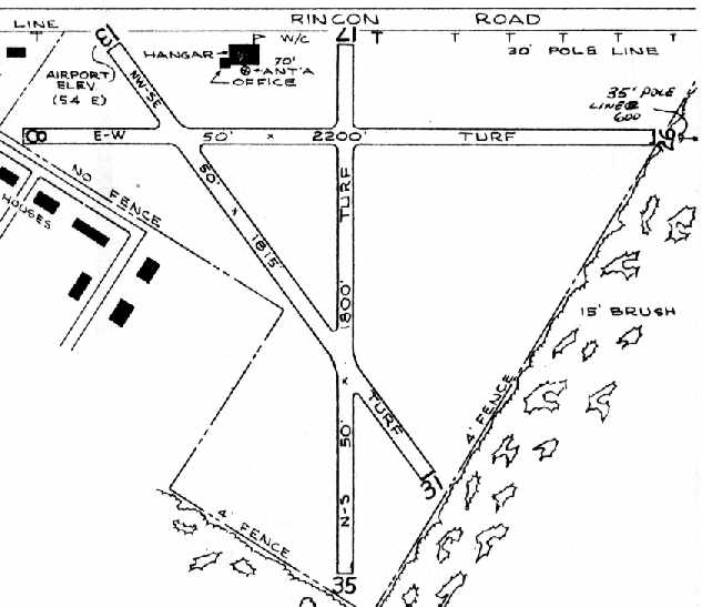
The 1966 TX Airport Directory (courtesy of David Brooks) depicted Worsham Field as having 3 turf runways,
with the longest being the 2,200' Runway 8/26.
A hangar with attached office was depicted on the north side of the field.
The field was said to offer minor repairs & fuel.
The operator was listed as the Worsham Dusting Service, and the manager was listed as D.E. Montgomery.
The 1973 Brownsville Sectional Chart (courtesy of David Brooks) depicted Worsham Field as having a 2,200' unpaved runway.
At some point between 1973-75 the field was evidently renamed “Hunt”,
as that is hot it was depicted on the 1975 Brownsville Sectional Chart (courtesy of David Brooks).
It depicted Hunt as having a 2,200' unpaved runway.
The 1977 TX Airport Directory (courtesy of David Brooks) depicted the “Hunt Dusting” Airfield as having 3 turf runways,
with the longest being the 2,500' Runway 13/31.
A single building was depicted on the north side of the field.
The manager was listed as J.M. Hunt.
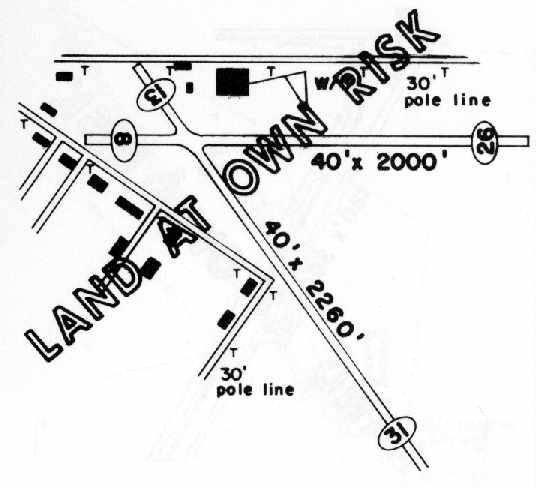
The 1984 TX Airport Directory (courtesy of David Brooks) depicted the Hunt Dusting Service Airfield as having 2 runways:
2,260' Runway 13/31 & 2,000' 8/26.
The former Runway 17/35 had apparently been abandoned at some point between 1977-84.
Three buildings were depicted on the north side of the field.
The field was prominently labeled as “Land at own risk.” The manager was listed as J.M. Hunt.
The last aeronautical chart depiction which has been located of Hunt Field
was on the 1985 Brownsville Sectional Chart (courtesy of David Brooks).
It depicted Hunt as having a 2,200' unpaved runway.
Hunt Field may have been closed (for reasons unknown) at some point between 1985-86.
Michael Morgan recalled, “I went back once, in 1986,
and the field was abandoned with only the hangar still standing.”
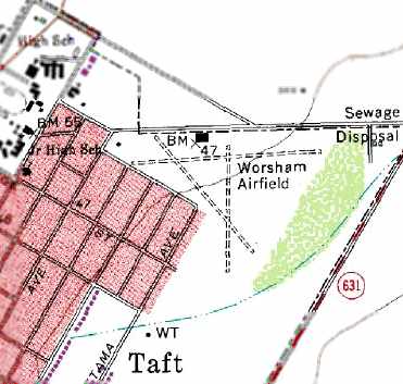
The 1989 USGS topo map still depicted “Worsham Airfield” as having 3 unpaved runways,
with the hangar on the north side of the field.
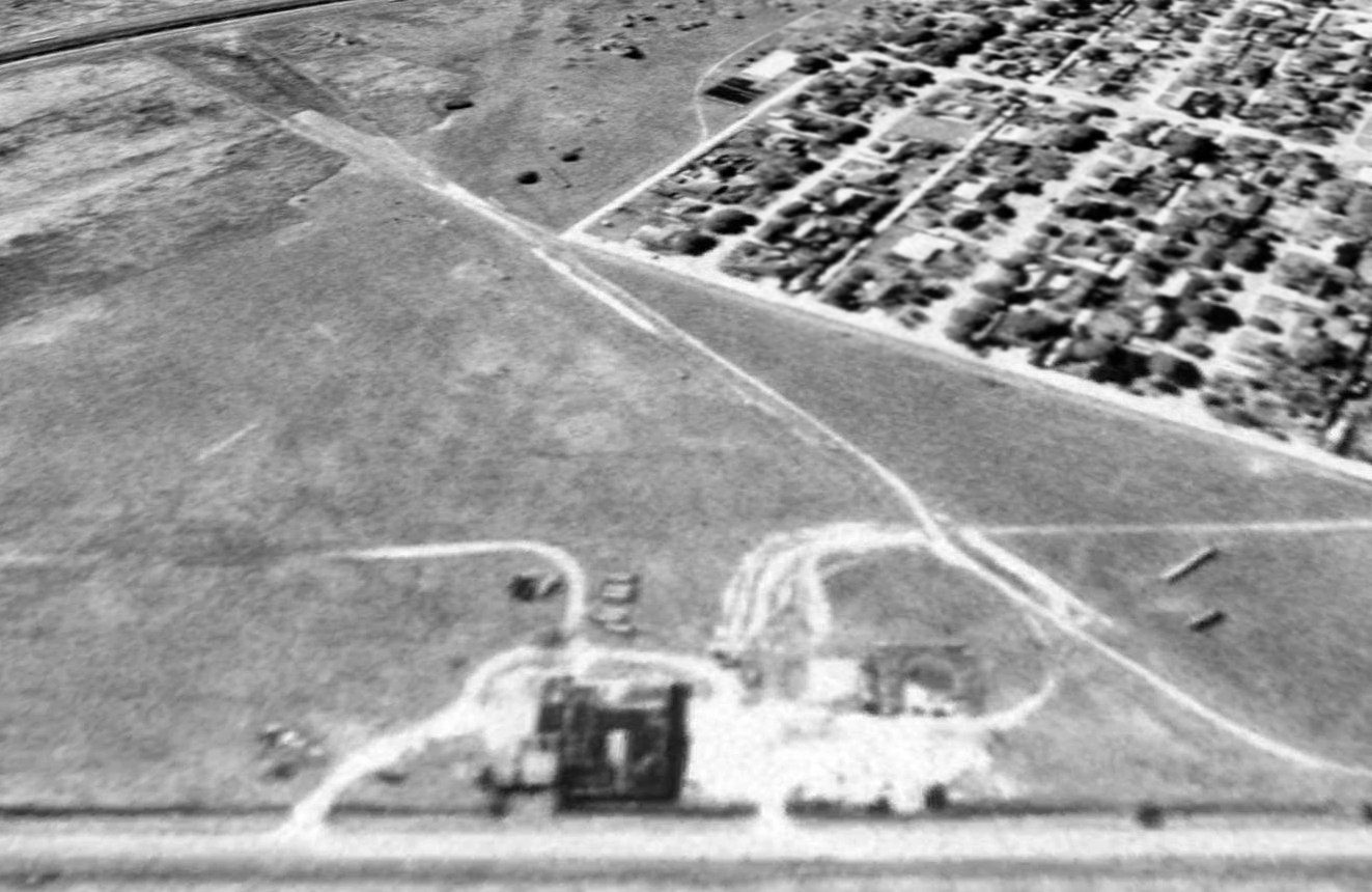
A 1995 USGS aerial view looking south at the site of Worsham, Field showed the 3 former runways still remained recognizable,
and the hangar on the north side of the field remained standing as well.
Houses had been built adjacent to the southwest of the airfield.
A 3/31/08 aerial view showed that the Worsham Field hangar had been removed at some point between 1995-2008.
A 2014 aerial view looking south showed the ghosted path of the 3 Worsham Field runways was still plainly recognizable in the still-clear grass field,
and the foundation of the hangar remained on the north side.
A 2016 photo looking south at the hangar foundation at the site of Worsham Field.
The site of Worsham Field is located southeast of the intersection of Rincon Road & Tutt Avenue.
____________________________________________________
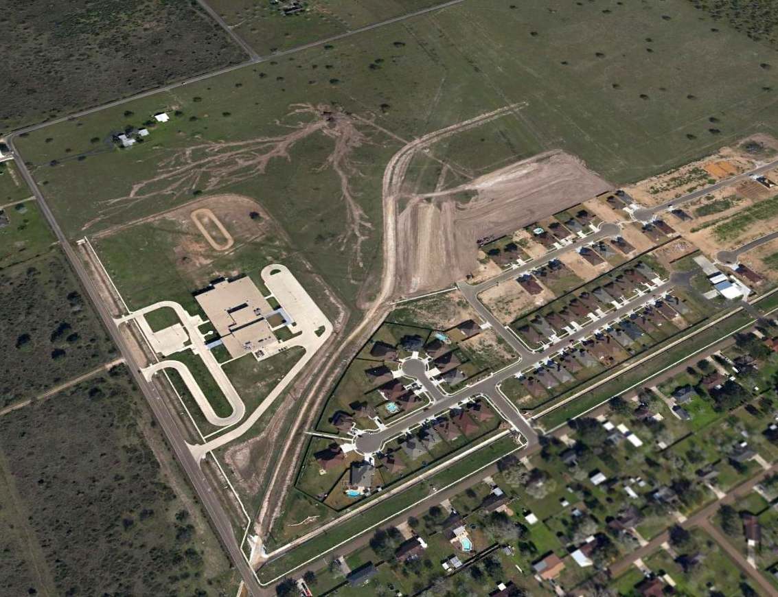
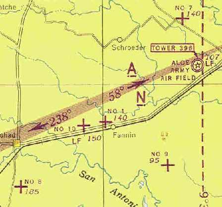
Aloe Army Airfield / Victoria County Airport, Aloe, TX
28.78, -97.09 (Southwest of Houston, TX)
No airfield was depicted at this location on the April 1942 San Antonio Sectional Chart (courtesy of Ron Plante).
Aloe Army Air Field, an advanced single-engine training field for fighter pilots,
was opened in 1943 on a 1,909-acre tract 5 miles southwest of Victoria.
A 5/15/43 AAF list of airfields of the Gulf Coast Training Center (courtesy of Ron Plante)
described Aloe Field as having 4 concrete runways, with the longest being the 5,600' north/south strip.
It listed Aloe as having 5 satellite fields: Auxiliary Field #1,
Aloe Aux #7 (7.6 miles northwest of Victoria), of which no trace remains,
Aloe Aux #8 (4.2 miles south of Goliad), of which no trace remains,
Aloe Aux #9 (15 miles southwest of Victoria), of which no trace remains,
and Aloe Aux #10 (7.2 miles ENE of Goliad).
Aloe became the new home of the Lake Charles Army Flying School, which relocated from Lake Charles, LA.
Using the North American AT-6 Texan & Curtis P-40, cadets were schooled in flying & in ground & aerial gunnery.
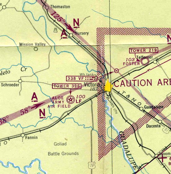
Aloe AAF, as depicted on the 1943 San Antonio Sectional Chart (courtesy of Chris Kennedy).
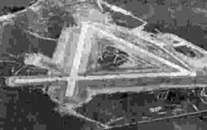
A 10/25/43 aerial view looking north at Aloe Army Airfield from the 1945 AAF Airfield Directory (courtesy of Scott Murdock).
The July 1945 San Antonio Sectional Chart (courtesy of Chris Kennedy) depicted Aloe AAF as having its own control tower.
Soon after V-J Day the government made plans to reassign the field as a subpost of Foster Army Air Field (a larger installation northeast of Victoria),
but both Aloe & Foster were closed in 1945.
Aloe AAF was declared surplus by the War Department in 1946 & turned over to the War Assets Administration for disposal.
Aloe Field, with its 304 buildings, was transferred to Victoria County in 1948,
after which the site became Victoria County Airport.
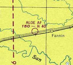
The 1949 San Antonio Sectional Chart (courtesy of Chris Kennedy) described Victoria County Airport
as having a 5,600' hard-surface runway.
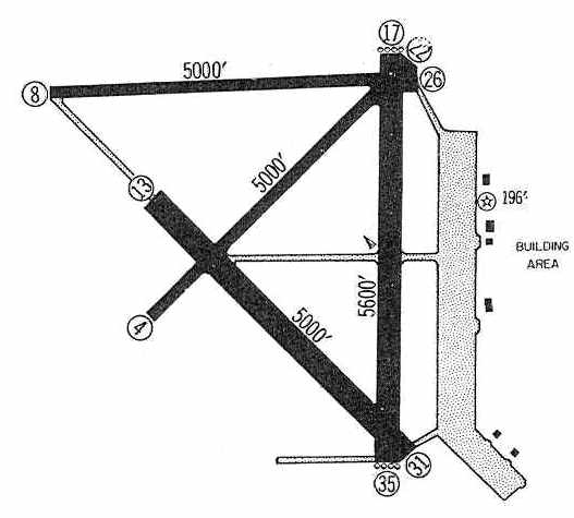
The Victoria County Airport was depicted in the 1960 Jeppesen Airway Manual (courtesy of Chris Kennedy)
as having four 5,000' paved runways, as well as a very large ramp with numerous buildings on the east side of the field.
In 1960 the County Airport was moved to Foster Field, and Aloe Field was closed.
The last aeronautical chart depiction which has been located showing Victoria County Airport in operation was on the February 1961 San Antonio Sectional Chart.
It depicted Victoria County Airport as having 4 paved runways, with the longest being 5,600'.
Victoria County returned Aloe Field back to the Federal Government in 1961.
The base was declared surplus by the General Services Administration in 1962 & offered for sale.
The land was broken into parcels & sold in April 1963.
A portion of the former airfield was purchased in 1963 by a local businessman,
who leased a runway on a year-to-year basis to the “Rod Benders”, a hot rod club, to use the runway for drag races.
The club could not make any permanent improvements at the property. They named the facility “Six Flags Drag Way”.
Aloe Field was still depicted on the 1964 San Antonio Sectional Chart (courtesy of Bill Suffa), although it was labeled "closed".
The Aerodromes table on the chart described Aloe as having a total of 4 runways, with the longest being a 5,655' concrete runway.
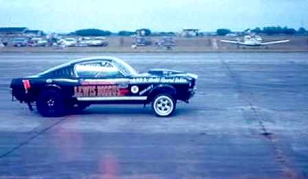
An undated (circa 1960s?) photo of a 1960s-era Mustang competing in a drag race on an Aloe runway.
Note the hangar in the background at left, and a Piper or Beechcraft on the right.
In 1968 G.A. Kupfernagel purchased the property which had been used for drag racing, and named it “Six Flags Raceway Park”.
In 1973 Kupfernagel sold the land & equipment.
The new owner continued to operate races at the airfield until the end of 1975, when he sold the land to a developer.
The west side of the airfield (including the runways) has become an industrial park.
The east side has become a housing development.
The remaining runways of the former Aloe airfield were not depicted at all on the 1987 USGS topo map,
just several buildings on the east side of the field.
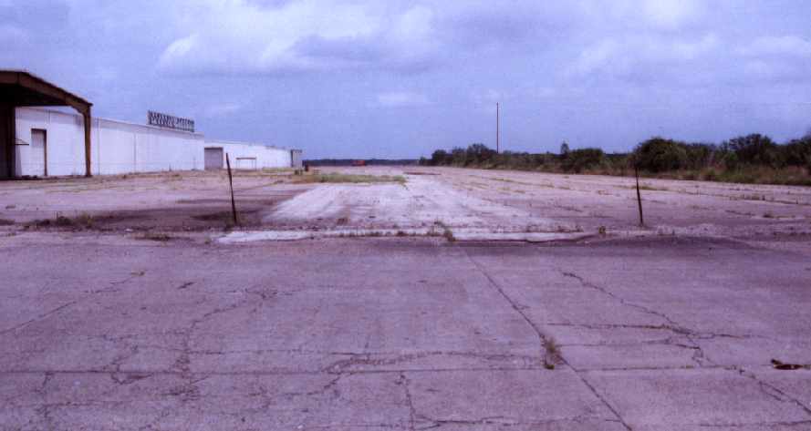
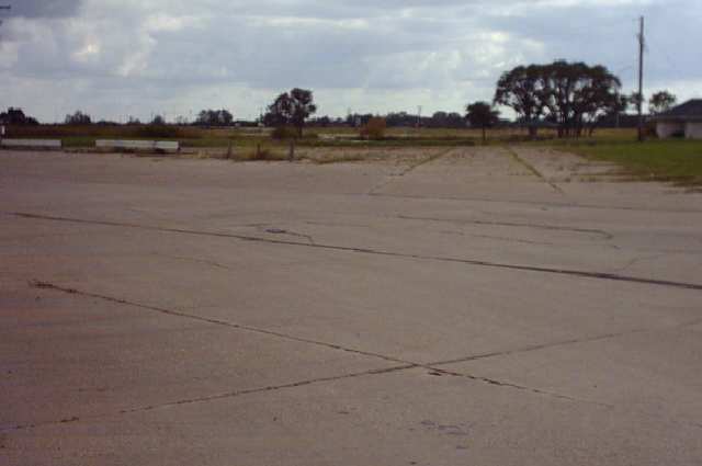
A 1990 photo by John Voss of hangars & the ramp of the former Aloe AAF.
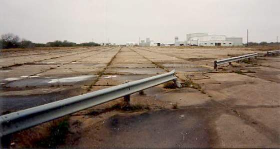
A 1994 photo by Scott Murdock of pavement of a former runway at Aloe AAF.
As seen in a 1995 USGS aerial view looking west, the Aloe airfield consisted of 4 concrete runways (the largest is 5,800' long), taxiways & a large ramp, the vast majority of which still existed.
Industrial buildings had been built on the southern end of the north/south runway, and a railroad yard had been built on the southern end of the ramp.
According to Mike Erwin (who visited the site in 1997), remnants of the control tower were still visible.
Aloe was not depicted at all (even as an abandoned airfield) on either recent aeronautical charts, which is unusual for such a large airfield.
A 2005 aerial view showed that Route 463 had been constructed at some point between 1995-2003 right through the center of the former airfield.
But large portions of 4 runways & the extensive ramp still remained intact.
Navy flight instructor Michael Strobach reported in 2003, "I, too, was surprised that the field was not depicted on the sectional.
It's been industrialized, but the field is clearly visible even from far away.
One difference I noticed between [the above] 1995 picture & today
is that a north/south road has been constructed that runs right through the middle of the field."
Scott reported that the site of Aloe AAF "looked much as it did on my first visit in 1994."
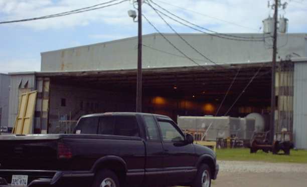
A 2003 photo by Erik Vela of a former Aloe hangar, now reused for fuel storage.
A 2003 photo by Erik Vela, looking west along the former Runway 27.
A 2003 photo by Erik Vela, looking southwest along Aloe's former ramp.
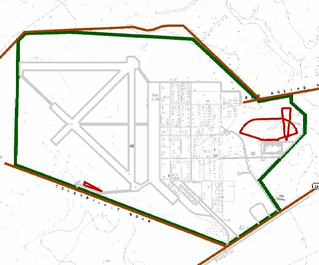
A 2003 Army Corps of Engineers diagram of the WW2-era boundaries of Aloe AAF.
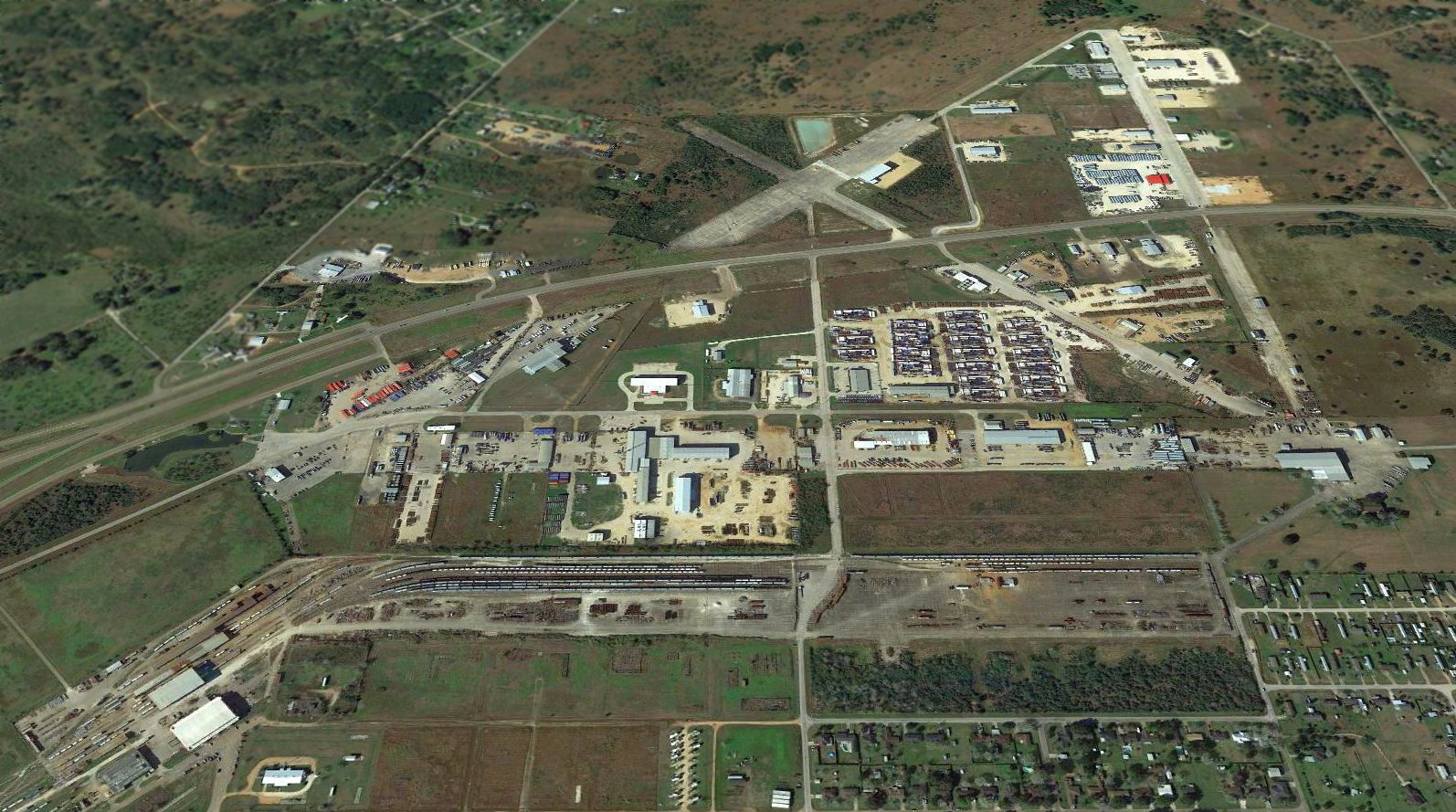
A 2016 aerial view looking west showed that the vast majority of the Aloe airfield still remained intact, even after being bisected by a highway.
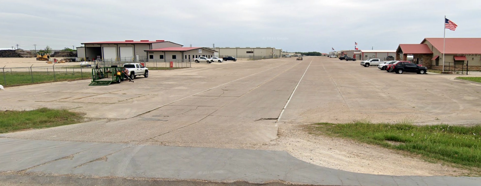
A 2023 photo looking west along the former Aloe AAF Runway 26, reused as Enterprise Drive.
The site of Aloe AAF is located on Route 59, near Route 175.
See also:
The Handbook of Texas History Online.
A 1996 Army Corps of Engineers Report.
____________________________________________________
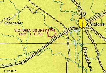
Aloe Auxiliary Army Airfield #10, Fannin, TX
28.7, -97.28 (West of Victoria, TX)
A 10/25/43 aerial view looking north at Aloe Army Airfield Auxiliary #10 from the 1945 AAF Airfield Directory (courtesy of Scott Murdock).
This field was used during WW2 as one of 5 satellite fields for Aloe AAF (12.4 miles east-northeast),
which was a center for advanced flight training in single engine aircraft.
Aloe Aux #10 was evidently built at some point in 1943,
as it was not depicted at all on the 1943 San Antonio Sectional Chart (courtesy of Chris Kennedy),
but it was depicted on a 1943 AAF map of Foster Field & surrounding airfields.
A 5/15/43 AAF list of airfields of the Gulf Coast Training Center (courtesy of Ron Plante)
described Aloe Auxiliary Field #10 as having 3 asphalt 4,000' runways.
The 1945 AAF Airfield Directory (courtesy of Scott Murdock) described Aloe Army Auxiliary Airfield #10
as a 943 acre “quadrangular” property having 3 concrete 4,000' runways.
The field was said to not have any hangars,
to be owned by the U.S. Government, and operated by the Army Air Forces.
The earliest aeronautical chart depiction which has been located of Aloe Aux #10
was on the July 1945 San Antonio Sectional Chart (courtesy of Chris Kennedy).
It depicted “#10” as an auxiliary airfield.
The last aeronautical chart depiction which has been located of this airfield as active
was on the 1949 San Antonio Sectional Chart (courtesy of Chris Kennedy).
But it was somewhat confusingly labeled "Aloe AF", and described as having a 4,000' hard-surface runway.
The earliest photo which has been located of Aloe Aux #10 was a 10/1/59 USGS aerial view.
It depicted Aloe Aux #10 as having 3 paved runways, taxiways, and a paved ramp on the northeast side.
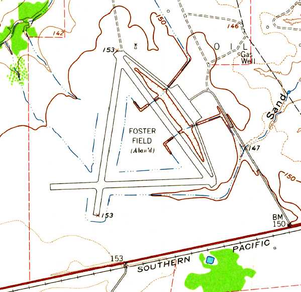
Aloe Aux #10 was abandoned at some point between 1949-62, as it was labeled "Foster Field (Aban'd)" on the 1962 USGS topo map.
That name may have been erroneous, as this airfield was an auxiliary of Aloe AAF, not Foster AAF.
It was labeled "Aband arpt" on the 1964 San Antonio Sectional Chart (courtesy of Bill Suffa).
It was labeled "Foster Air Force Auxiliary #2" on the 1978 USGS topo map,
but according to other sources, that field was located elsewhere (18 miles NNW of Victoria).
The 1987 USGS topo map labeled the field as “Foster Field (Aban'd)”,
and depicted it as having 3 paved runways, taxiways, and a paved ramp on the northeast side.
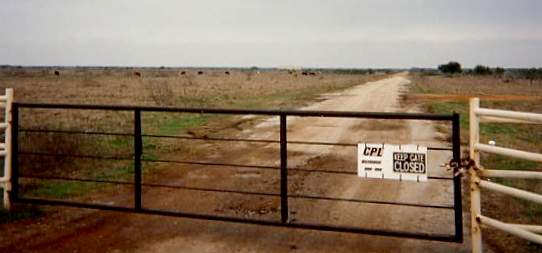
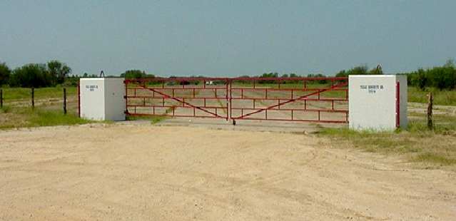
A 1994 photo by Scott Murdock of the gate leading to Aloe Aux #10.
As of 1994, the runways were being reused for open storage of industrial equipment.
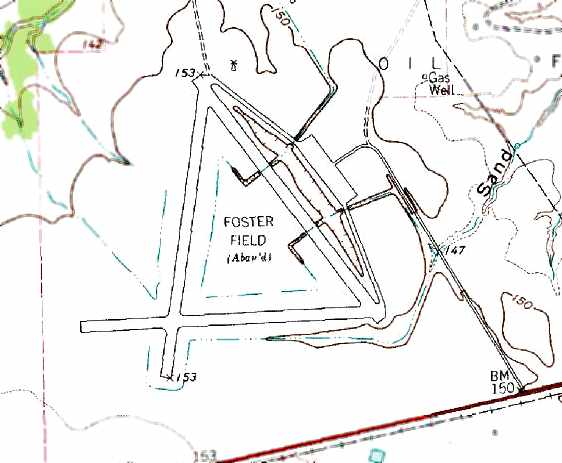
The 1995 USGS aerial photo showed the Aloe Aux #10 airfield to remain intact,
with three 4,000' paved runways, taxiways & a ramp.
A single building was on the ramp, presumably of post-war (civilian) construction.
Aloe Aux #10 was still depicted as an abandoned airfield on 2003 aeronautical charts.
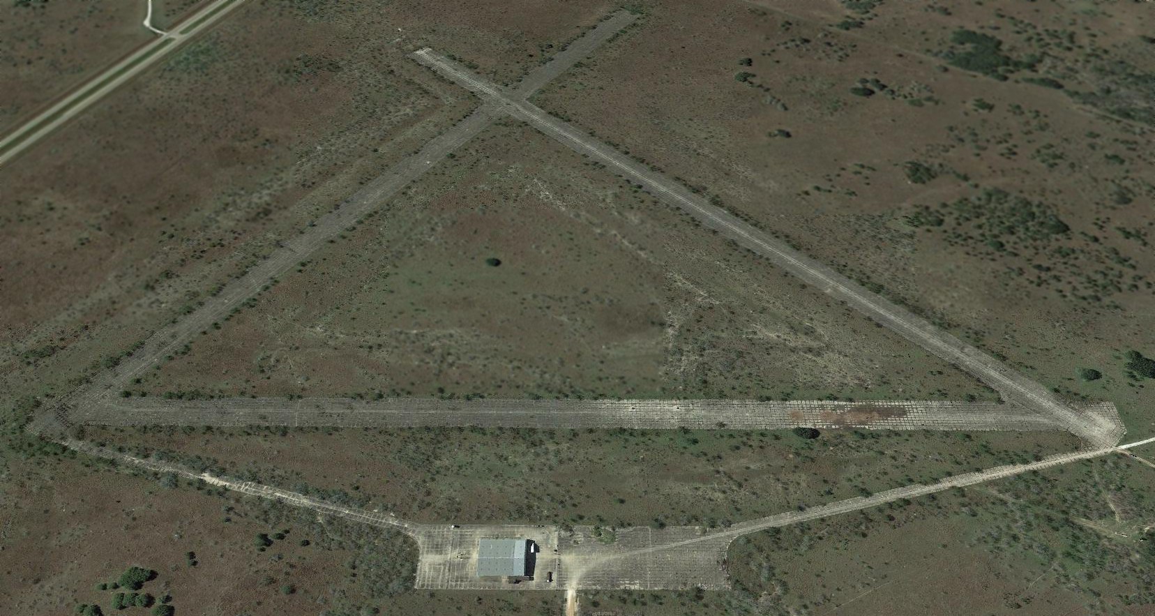
A 2016 aerial view looking southwest depicted Aloe Aux #10 to remain unchanged as seen in 1995.
Aloe Aux #10 is located on the north side of Route 59, 7 miles east-northeast of Goliad, TX.
____________________________________________________
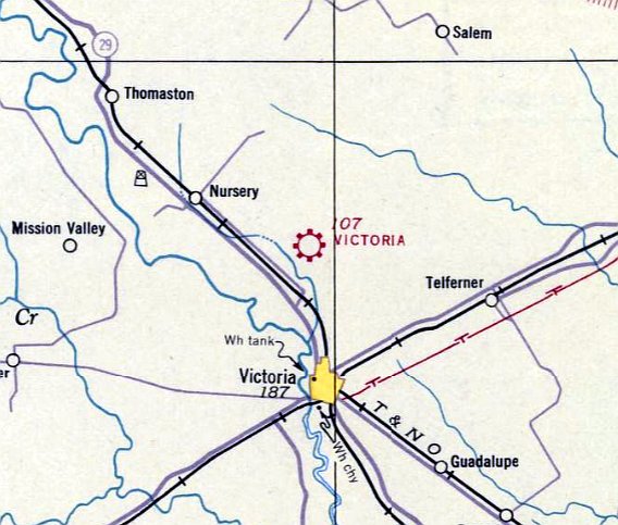
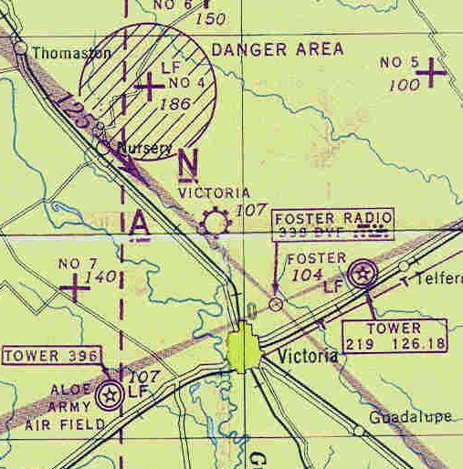
Nursery Field / Foster Auxiliary Army Airfield #4, Thomaston, TX
28.97, -97.06 (North of Victoria, TX)
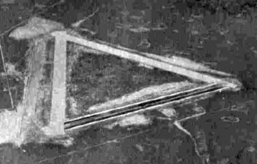
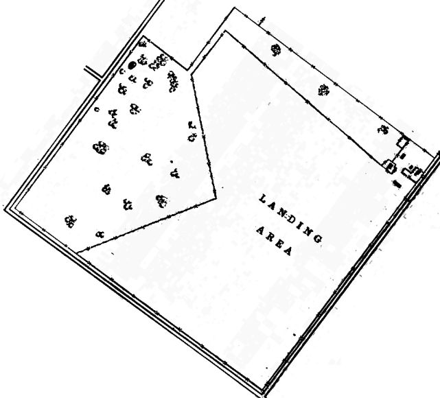
A 10/25/43 aerial view looking north at “Foster Field Auxiliary #4 (Nursery Field)” from the 1945 AAF Airfield Directory (courtesy of Scott Murdock).
This field was used during WW2 as one of 4 satellite fields for Foster AAF (13 miles southeast),
which was a center for advanced flight training in single engine aircraft.
The date of construction of Nursery Aux AAF has not been determined.
It was evidently built at some point in 1943,
as it was not depicted at all on the 1943 San Antonio Sectional Chart (courtesy of Chris Kennedy),
but it was depicted on a 1943 AAF map of Foster Field & surrounding airfields.
The military property at Nursery consisted of a total of 472 acres.
A 5/15/43 AAF list of airfields of the Gulf Coast Training Center (courtesy of Ron Plante)
described Foster Auxiliary #4 as having 3 bitulithic runways, with the longest being the 5,540' northeast/southwest strip.
The earliest aeronautical chart depiction which has been located of Foster Auxiliary Airfield #4
was on the July 1945 San Antonio Sectional Chart (courtesy of Chris Kennedy).
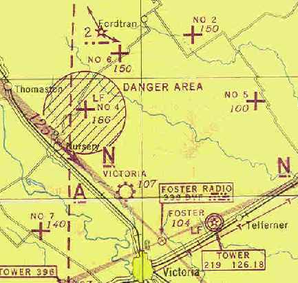
It depicted “#4” as an auxiliary airfield, around which was a circular “Danger Area”.
What was that for? Was this field also used as a target for gunnery or bombing?
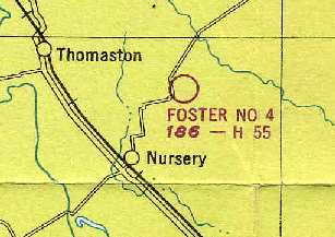
The Nursery airfield was labeled as "Foster #4" on the 1949 San Antonio Sectional Chart (courtesy of Chris Kennedy),
and described as having a 5,500' hard-surface runway.
It may have been abandoned at some point between 1949-52,
as Scott Murdock said that Nursery Airfield was brought back into service
as Foster AF Auxiliary Field #1 (2129) from about 1952-58.
The Nursery airfield was apparently abandoned again at some point between 1958-63,
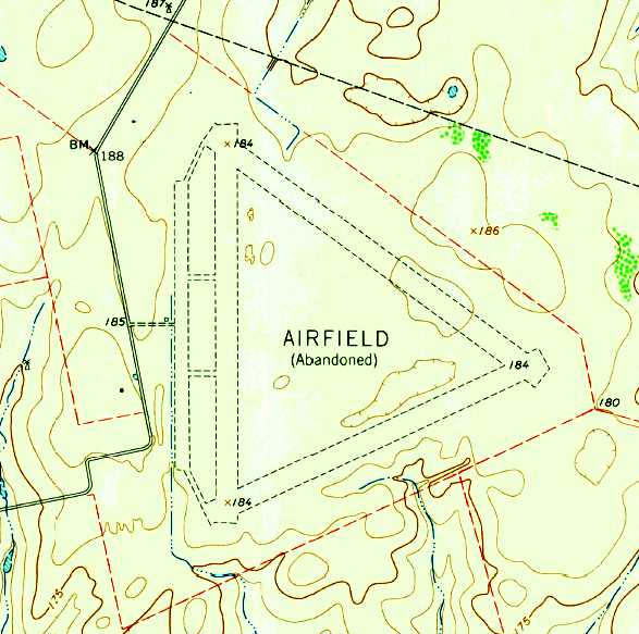
as it was labeled "Airfield (Abandoned)" on the 1963 USGS topo map.
The Nursery airfield was not depicted at all (not even as an abandoned airfield)
on the 1964 San Antonio Sectional Chart (courtesy of Bill Suffa).
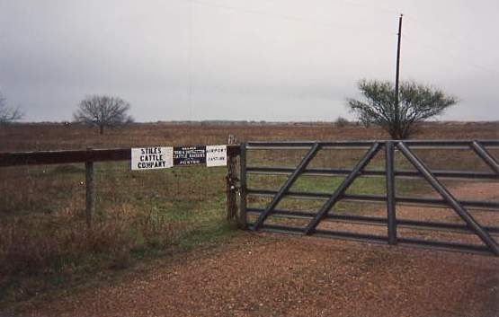
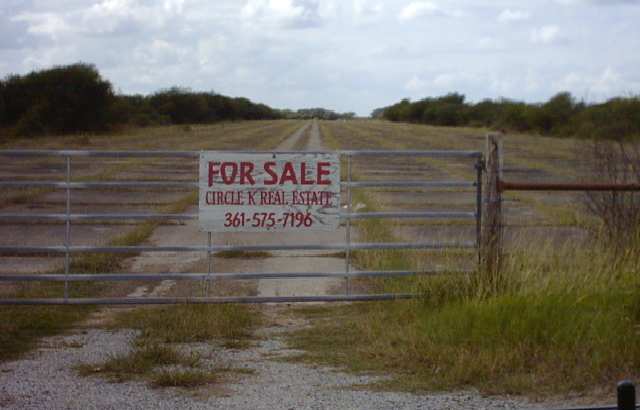
A 1994 photo by Scott Murdock of the gate which leads to the former Nursery Field.
Note the sign which still says "Airport Pasture".
As of 1994, the Nursery Field property was being used as a cattle feedlot.
Giving a clue to its former life, the access gate is still marked "Airport Pasture."
As of a 1995 USGS aerial view looking east, Nursery Field consisted of 3 runways (the largest is 5,400'), taxiways & a ramp.
The 2 diagonal runways were barely visible, and may have been plowed over.
The north/south runway was in much better condition, and may have remained in use at a later date than the other two.
Nursery AAF was depicted as an abandoned airfield on recent Sectional aeronautical charts,
and was depicted (but labeled simply "Airfield (Abandoned)" on recent USGS topo maps.
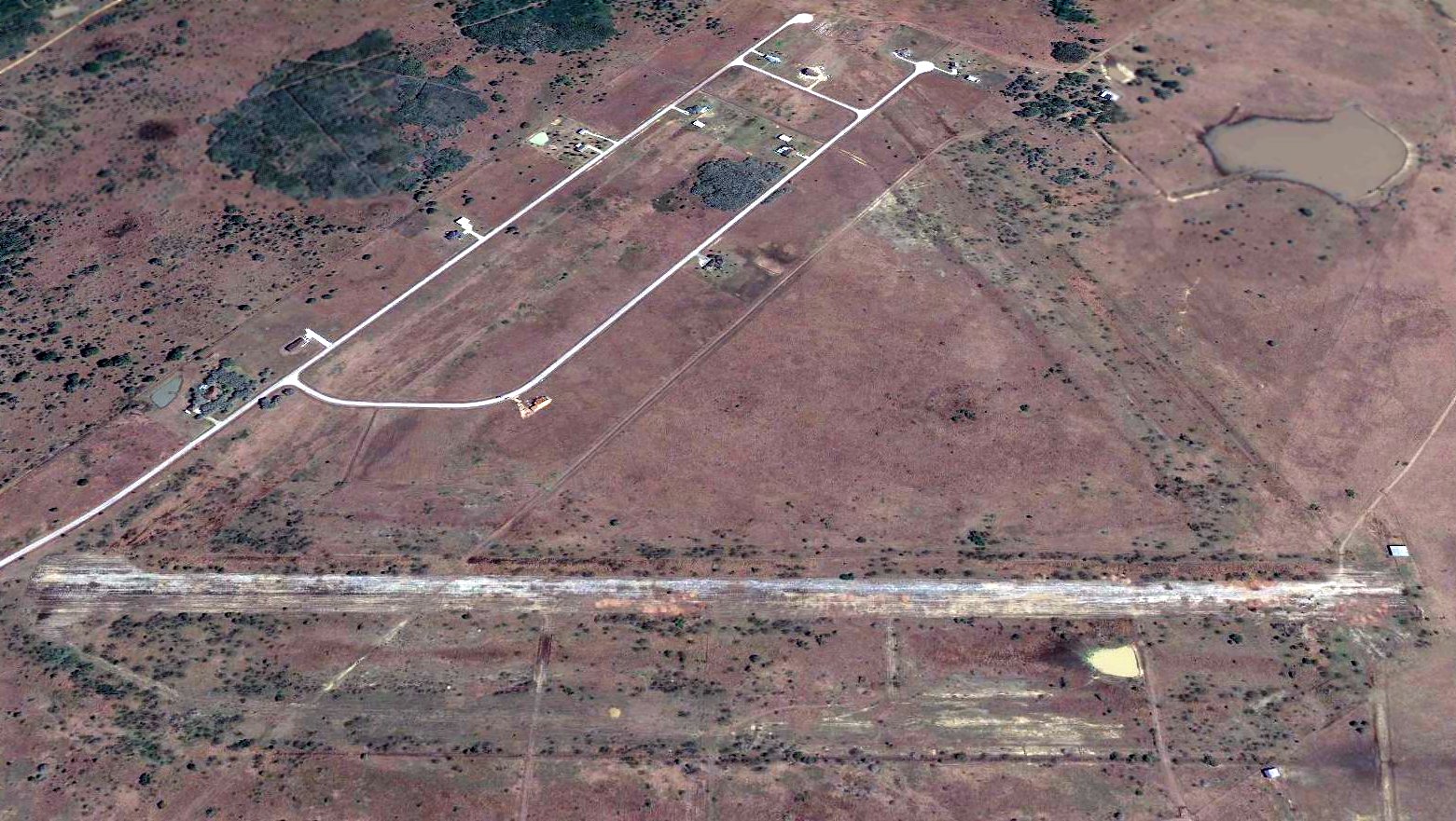
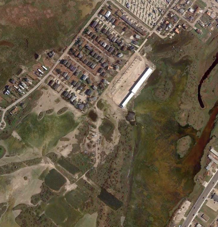
A 2017 aerial view looking east showed Nursery Field's northwest/southeast runway had been completely removed, and replaced by several streets & houses.
Traces of the southwest/northeast runway were only barely recognizable.
The site of Nursery Field is located on Route 87, near Route 447, 12.5 miles north-northwest of Victoria, TX.
____________________________________________________
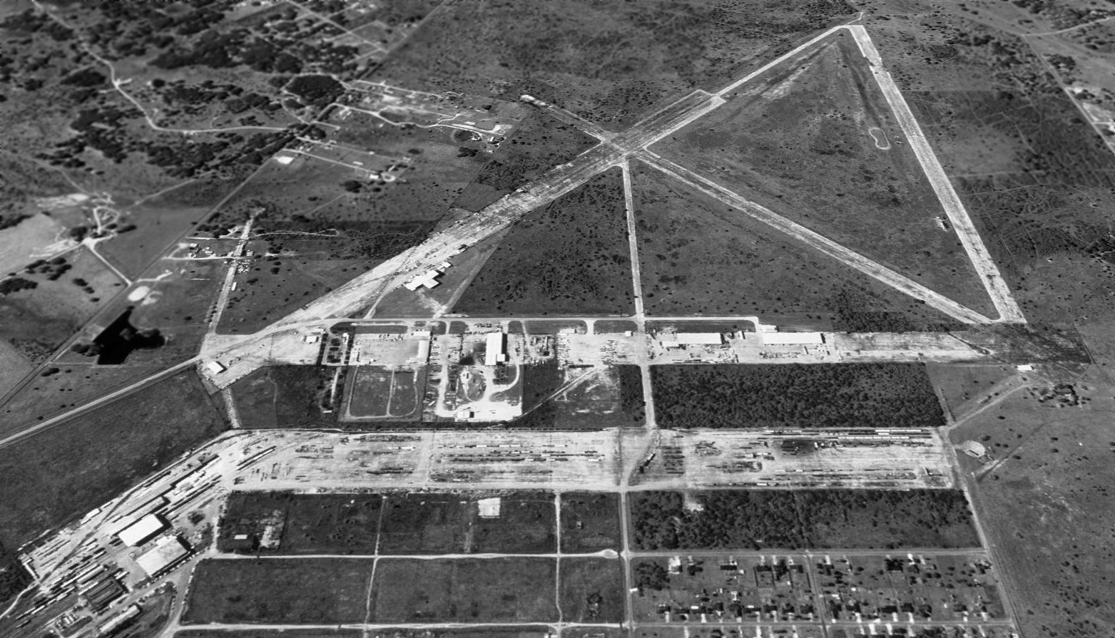
Matagorda Island Gunnery Range Army Airfield / Matagorda Island AFB, Matagorda Island, TX
28.325, -96.463 (Northeast of Corpus Christi, TX)
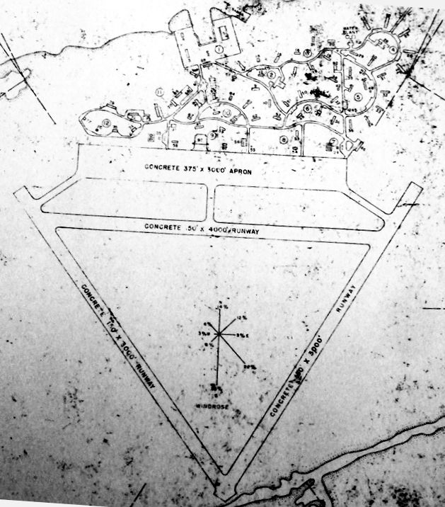
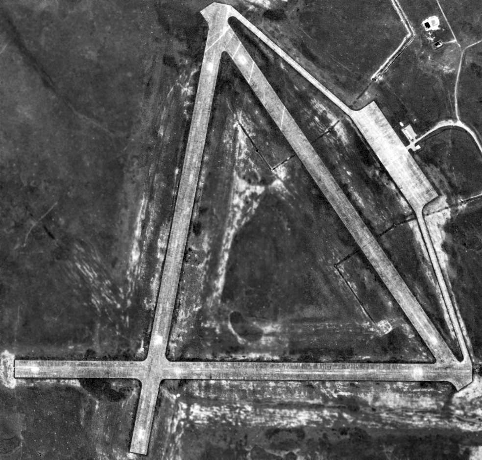
A 1942 depiction of the planned Matagorda Island Army Airfield (from the TX State Archives, courtesy of Ron Plante).
No airfield was depicted at this location on the September 1942 San Antonio Sectional Chart.
The earliest depiction which has been located of this military airfield built on a narrow barrier island on the Gulf of Mexico
was a 1942 depiction (from the TX State Archives, courtesy of Ron Plante), which evidently depicted plans for the yet-unbuilt airfield.
It depicted 3 concrete runways, with the east/west runway being labeled as 4,000', whereas the other 2 runways were labeled as only 3,000'.
Note that this is geometrically impossible for the depicted equilateral triangle shape.
A complex set of curved roads was depicted on the north side of the large concrete apron.
Matagorda Island Army Airfield was built to support the surrounding 50,825 acre Matagorda Island Bombing Range,
which conducted air-to-air & air-to-ground gunnery training.
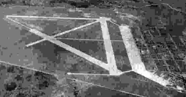
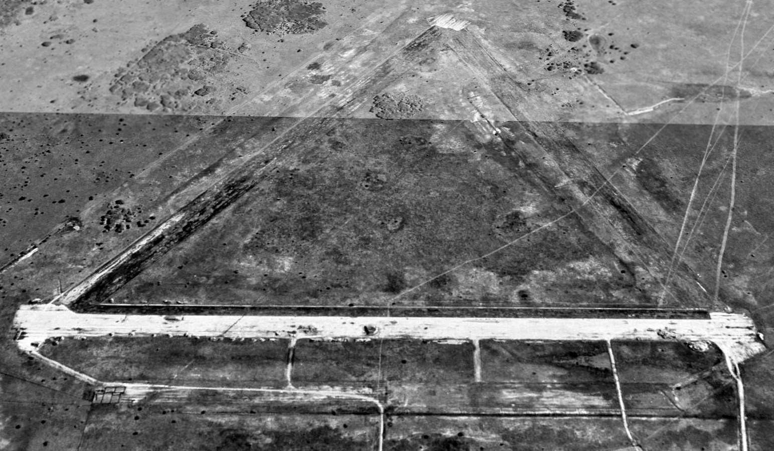
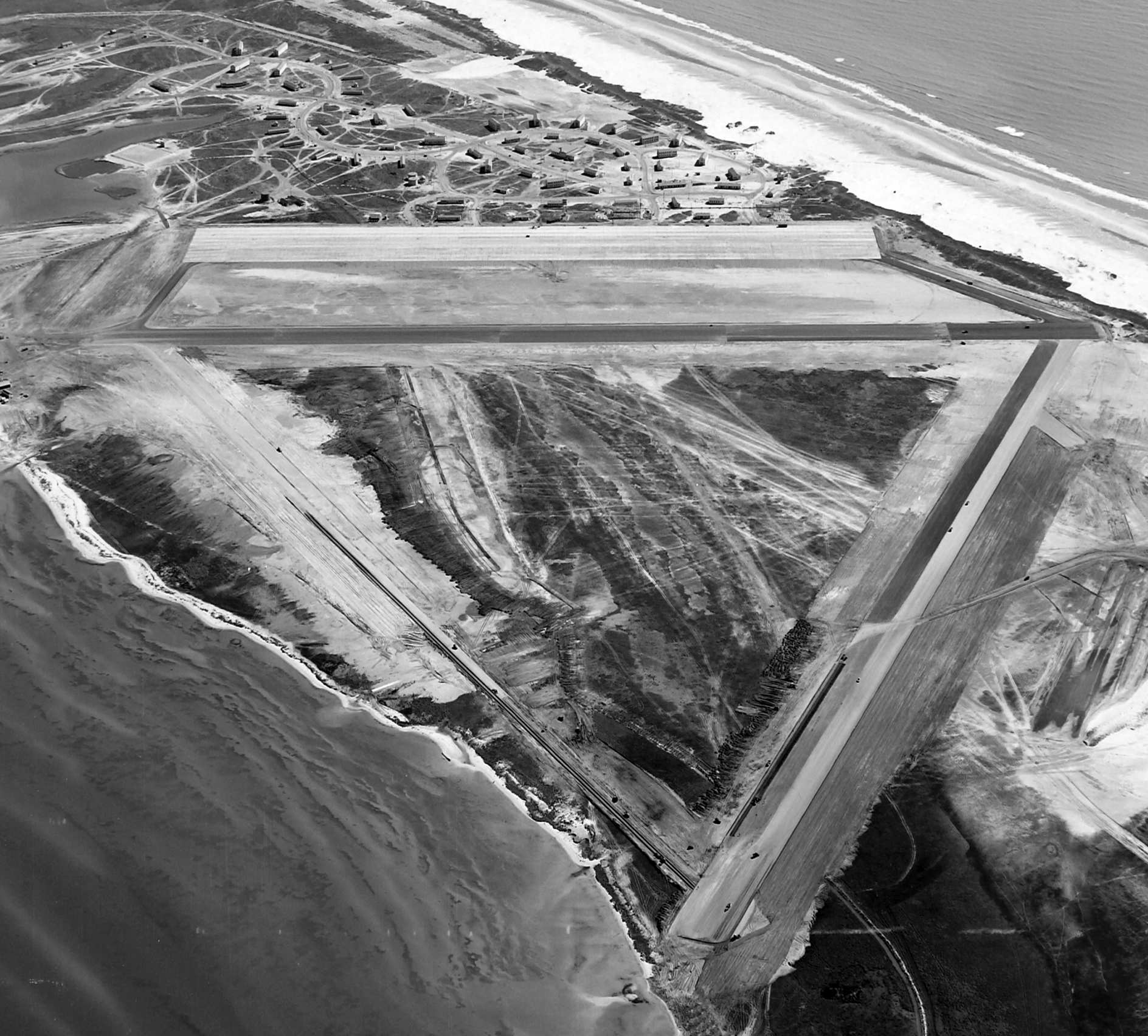
The earliest photo which has been located of Matagorda Island AAF was an 11/13/42 aerial view looking north (from the National Archives, courtesy of Brian Rehwinkel).
Brian Rehwinkel noted the photo “shows the field early in its life. The original field consisted of three 4,000' x 150' runways.
Notice the busy field... 49 aircraft on the runways & the apron.”
A 5/15/43 AAF list of airfields of the Gulf Coast Training Center (courtesy of Ron Plante)
described Matagorda Island as having 3 asphalt runways, with the longest being the 4,000' northeast/southwest & northwest/southeast strips.
The airfield was labeled as "Matagorda Island Gunnery Range" on the 1943 San Antonio Sectional Chart (according to Chris Kennedy).
The earliest aeronautical chart depiction which is available of this airfield was on the January 1944 San Antonio Sectional Chart.
It depicted “Matagorda Island Gunnery Range” as a military airfield.
Brian Rehwinkel noted, “I believe the two additional runways were added in early 1944.”
The airfield was reactivated as an Air Force Base for the Strategic Air Command in 1949.
The 1949 San Antonio Sectional Chart (according to Chris Kennedy) described "Matagorda Island (Army)" as having a 4,000' paved runway.
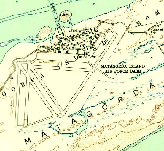
The 1952 USGS topo map depicted Matagorda Island AFB as having 6 paved runways, with numerous taxiways,
a large ramp, and a large number of streets & buildings.
In addition to the number of runways doubling since the 1942 depiction, the northeast/southwest runway had been extended to almost double its length.
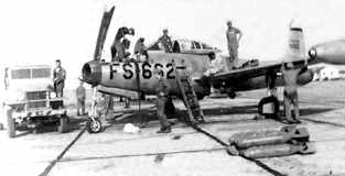
A circa 1950s picture captioned “Engineering personnel perform maintenance on the F-84G at Matagorda Island”,
from “The Story of the 184th/127th Kansas Air National Guard, 1941-86" (courtesy of Todd Greenberg).
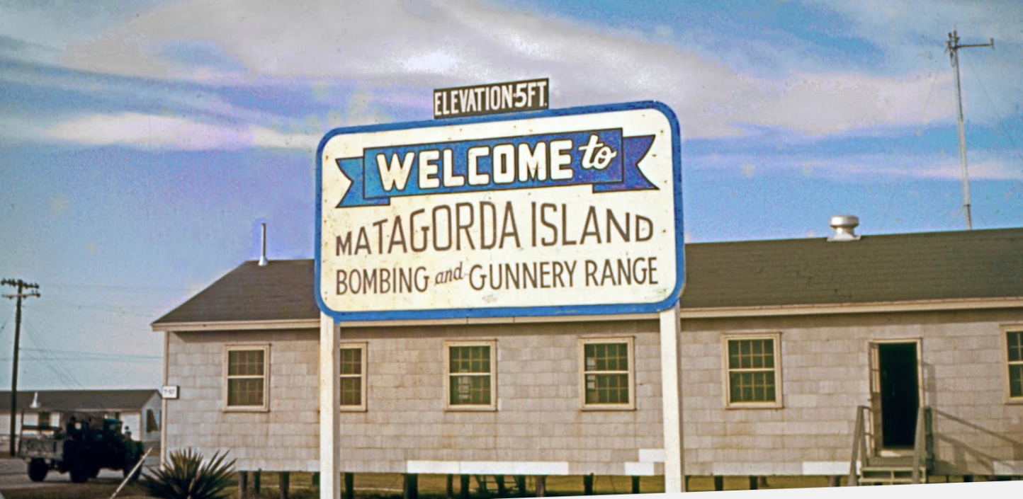
A 1957 photo by Norman Foote of the welcome sign for Matagorda Island Bombing & Gunnery Range.
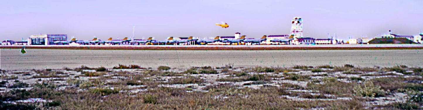
A 1957 photo by Norman Foote of 11 Air Force McDonnell F-101A (or 101C) Voodoos on the Matagorda Island ramp for gunnery practice,
and a rescue helicopter (model unidentified) in flight above them.
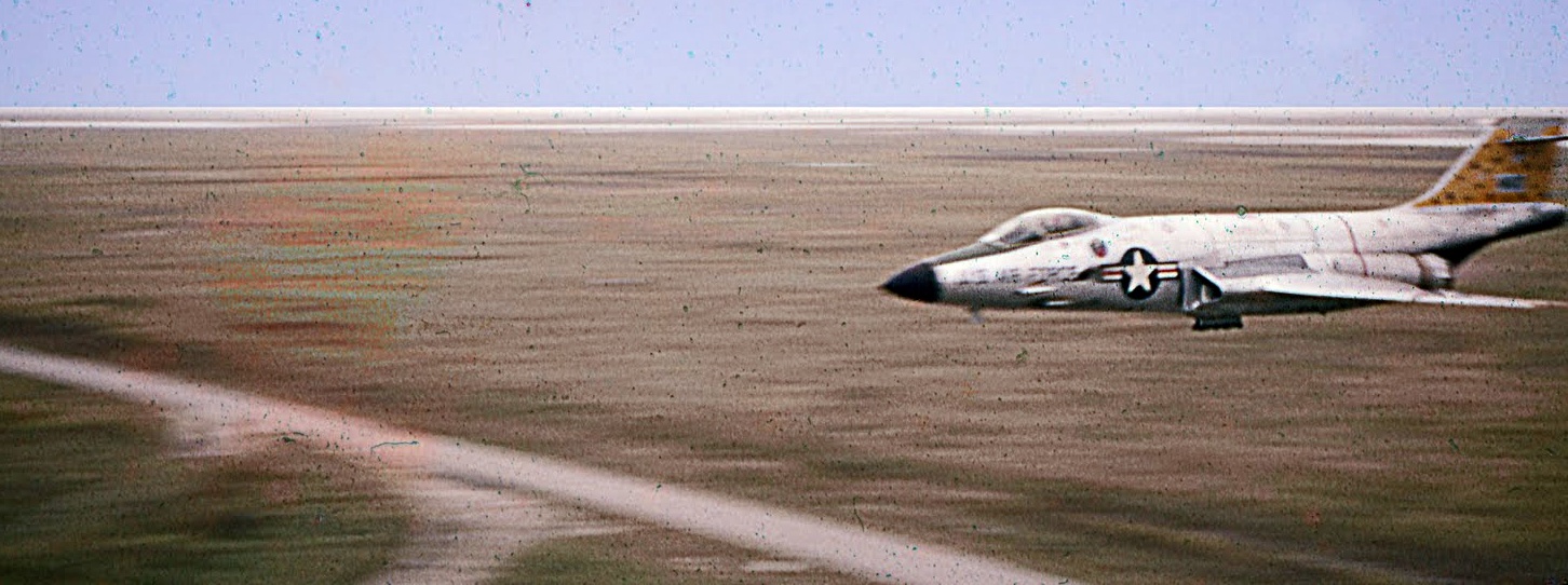
A 1957 photo by Norman Foote of an Air Force McDonnell F-101A (or 101C) Voodoo fighter making a high speed pass below the top of the Matagorda Island's range control tower.
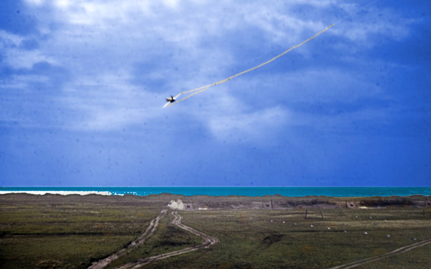
A 1957 photo by Norman Foote of an Air Force McDonnell F-101A (or 101C) Voodoo pulling up after a strafing run at Matagorda Island.
Note the dust still in the air behind the target immediately below the fighter.
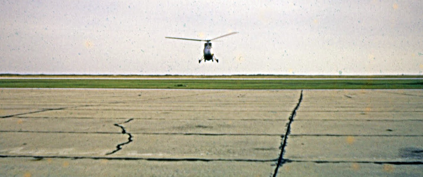
A 1957 photo by Norman Foote of an Air Force Sikorsky (model unidentified) landing at Matagorda Island Bombing & Gunnery Range to take him back to Foster AFB.
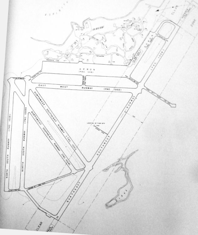
A circa 1960 plan of Matagorda Island AFB (from the TX State Archives, courtesy of Ron Plante)
shows that the northeast/southwest runway had been extended again (this time to the southeast) at some point between 1952-60.
The Matagorda Island Bombing Range was controlled at one time or another by Foster Field, Randolph AFB,
Carswell AFB, Bergstrom AFB, Chennault AFB, and Barksdale AFB.
Matagorda Island AFB was depicted as an active airfield on the 1964 San Antonio Sectional Chart (courtesy of Bill Suffa).
It was depicted as having a total of 6 paved runways (the longest being 8,000'),
its own control tower, VOR beacon, and NDB beacon.
The last aeronautical chart depiction which has been located of "Matagorda Island AF" was on the September 1970 Housoun Sectional Chart.
It depicted Matagorda as having 6 paved runways, with the longest being 8,000'.
Matagorda Island AFB was deactivated in 1975.
At some point after 1975 the Matagorda Island AFB property became a federal wildlife refuge.
In the 1980s & 1990s, Matagorda Island was used as a location for the Tethered Aerostat Radar System.
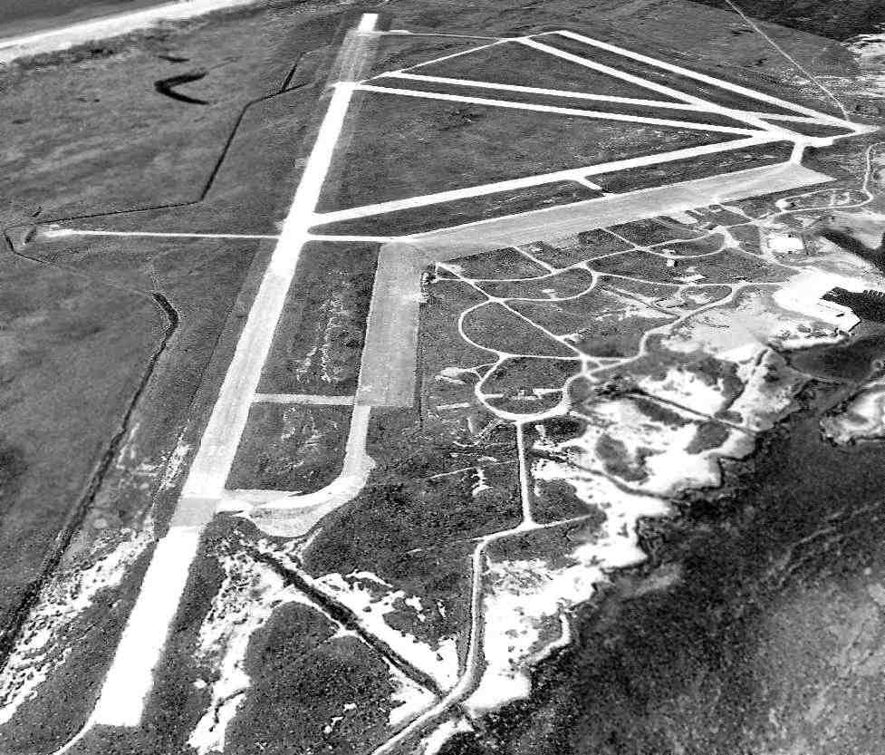
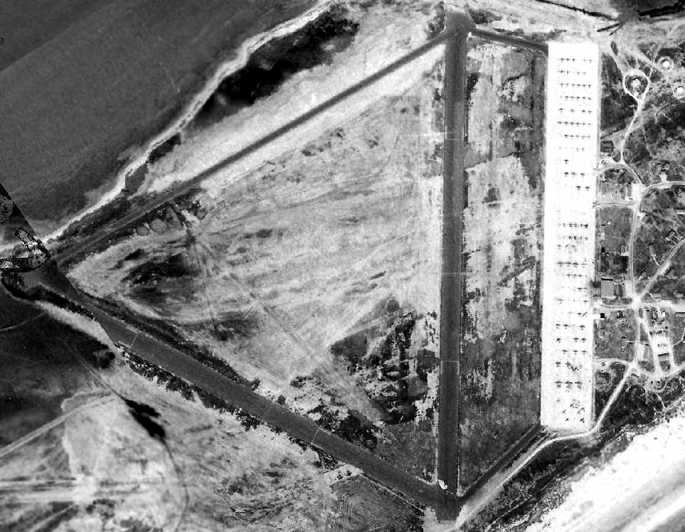
The earliest photo which has been located of the entire Matagorda airfield was a 1990 USGS aerial view looking southwest.
Note that runway numbers had been painted at some point on Runway 2/20, but then closed-runway X symbols had been added.
Short portions appeared to have been repaved with asphalt at either end of that runway, of which the total length of the paved surface is 10,800'.
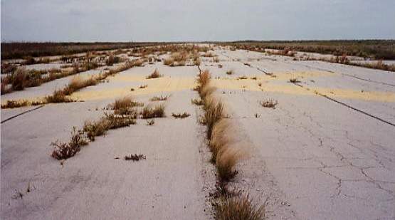
A series of 1994 photos by Scott Murdock of the remains of the Matagorda runways.
A 1994 photo by Scott Murdock of the remaining military buildings at Matagorda.
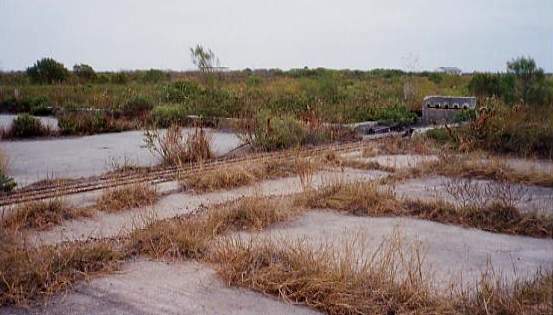
A 1994 photo by Scott Murdock of the foundation of a former hangar at Matagorda.
The March 1999 Houston Sectional Chart depicted the “Matagorda Island” airfield as “Closed”.
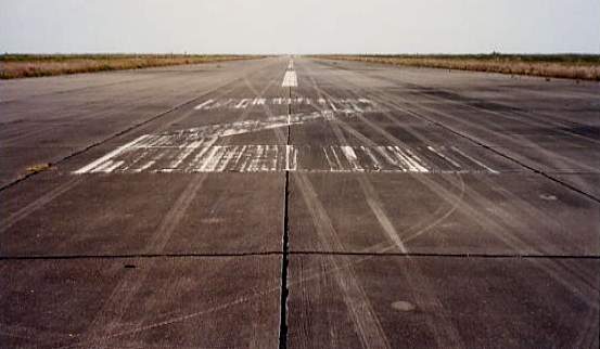
According to Jason Knutson (who visited the Matagorda Island AFB site in 2002),
"The longest runway still has visible markings on it & is in relatively good condition.
The tarmac & taxiways also still exist but have weeds growing everywhere.
There are also foundations remaining from some of the hangars."
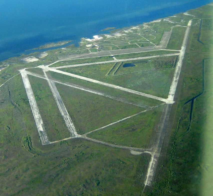
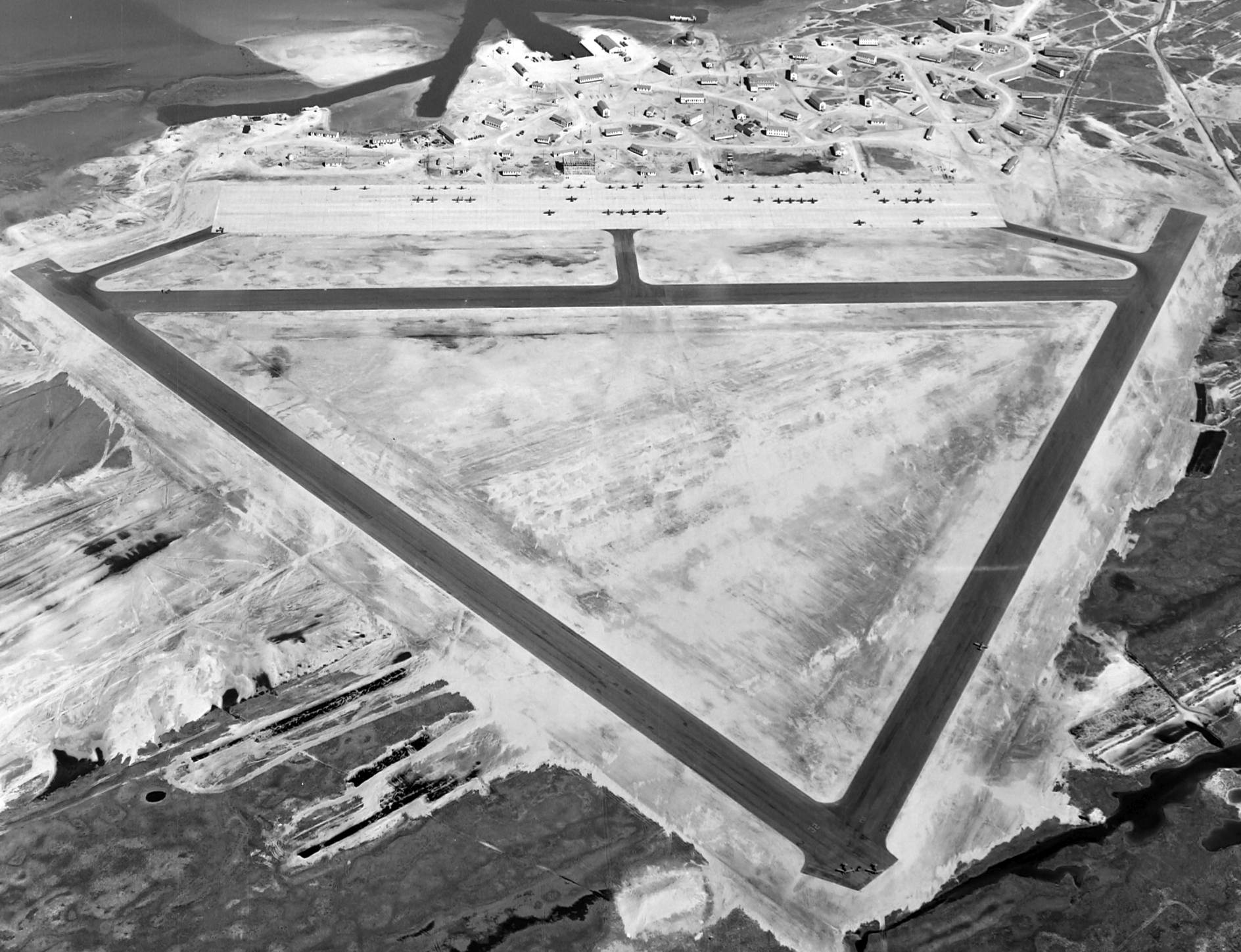
A 2009 aerial view looking north at the massive Matagorda AFB airfield by Hector Zuniga.
Hector reported, “The aerial views of the base plus the amazing weather & visibility were more than worth the 2 hour outward leg & return flight.”
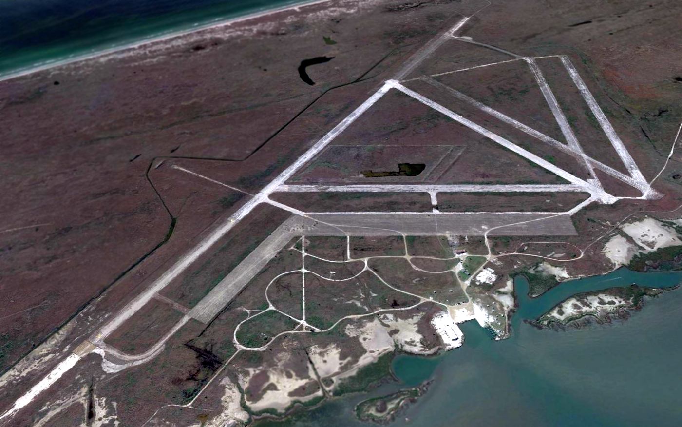
A 2013 aerial view looking south shows the massive Matagorda Island AFB remains intact though deteriorated.
See also: The Handbook of Texas Online
____________________________________________________
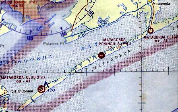
Barksdale (Gunnery Camp) Army Auxiliary Airfield / Matagorda Peninsula Army Airfield /
Matagorda Matagorda Club Airfield / Pierce Field (72TA), Matagorda Peninsula, TX
28.46, -96.29 (Northeast of Corpus Christi, TX)
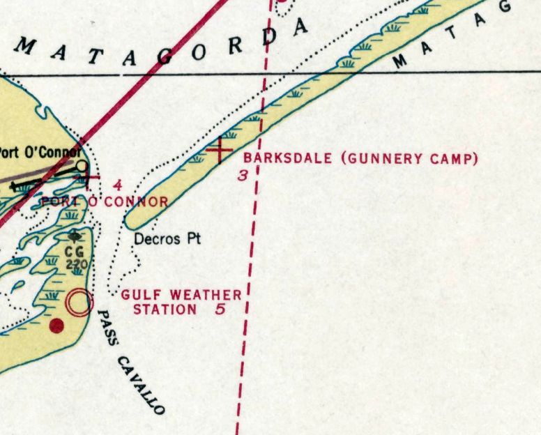
“Barksdale (Gunnery Camp)” Army Auxiliary Airfield, as depicted on the October 1938 San Antonio Sectional Chart.
No airfield was depicted at this location on the December 1936 San Antonio Sectional Chart.
This military airfield was constructed along a narrow island on the Gulf of Mexico.
According to Joe Benson, it was built during WW2 to support the Matagorda Bombing Range to the west, and was a sub-base of Foster AAF.
The earliest depiction which has been located of this airfield was on the October 1938 San Antonio Sectional Chart.
It depicted “Barksdale (Gunnery Camp)” as an auxiliary airfield.
It continued to be labeled “Barksdale (Gunnery Camp)” on the April 1942 San Antonio Sectional Chart (courtesy of Ron Plante).
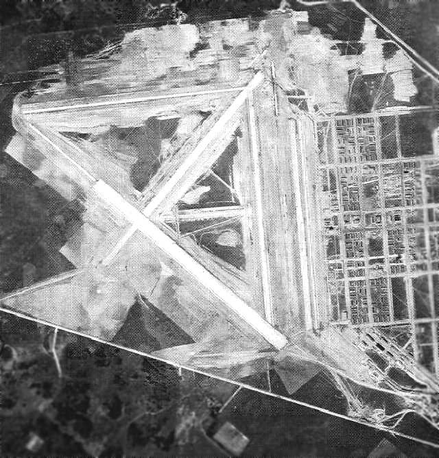
The earliest photo which has been located of Matagorda Peninsula AAF was an 11/13/42 aerial view (from the National Archives, courtesy of Brian Rehwinkel) taken during construction.
Brian Rehwinkel noted, “The island airfield was substantially complete at this time, but the paving is taking place. It looks like the cantonment area seems to be mostly ready.
The runways under construction are 4,000' x 150' & seem to stretch from the Gulf to the bay.”
A 5/15/43 AAF list of airfields of the Gulf Coast Training Center (courtesy of Ron Plante)
described Matagorda Peninsula as having 2 asphalt 4,000' runways.
The 1943 San Antonio Sectional Chart (according to Chris Kennedy)
labeled the airfield as "Matagorda Peninsula (Central Fixed Gunnery School)".
A 3/5/43 aerial view depicted over 100 aircraft on the Matagorda Peninsula AAF ramp.
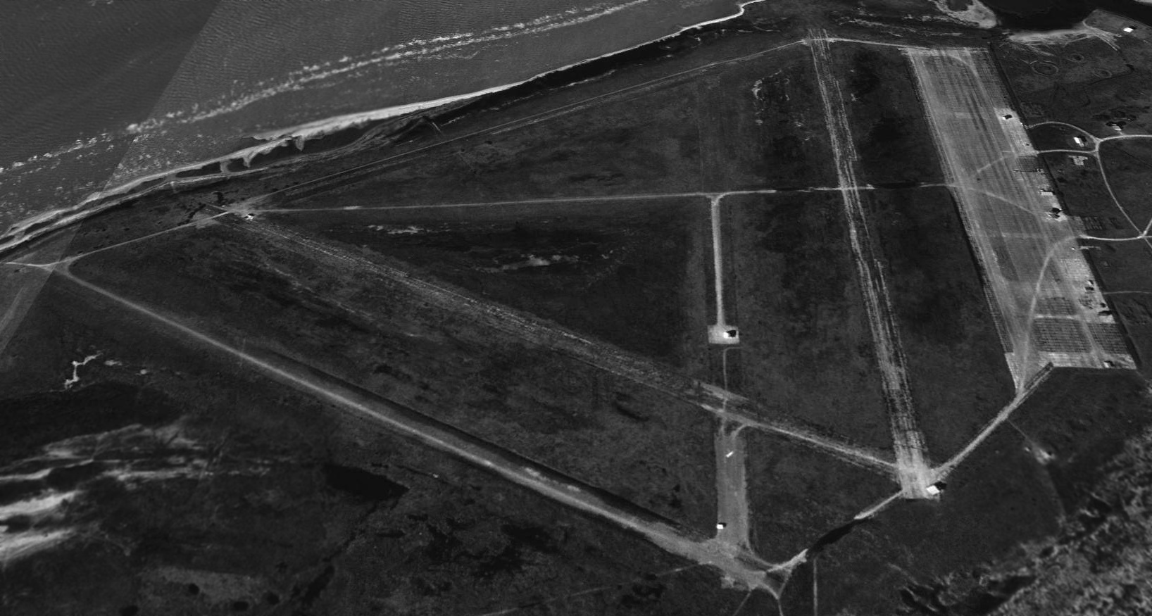
A 3/5/43 aerial view depicted Matagorda Peninsula AAF in its original configuration, with only 2 asphalt runways connected by a taxiway.
A large concrete ramp on the east side held an amazing array of over 100 aircraft.
A series of curved roads on the east side had dozens of buildings.
At some point after 1943 the airfield gained 3 more runways, bringing the total up to 5 runways.
The January 1947 Edwards Plateau WAC Chart depicted “Matagorda” as an auxiliary airfield.
The 1964 San Antonio Sectional Chart (courtesy of Bill Suffa) depicted "Matagorda Club" as a private airfield, with a total of 5 runways, the longest being a 4,285' asphalt runway.
According to Bill Hedrick, “From a conversation with 'Captain' Pierce, owner, there was apparently a plan to develop that area as an exclusive resort (prior to the 1980s)
that had a golf course & hotel but the developer apparently lost investors & abandoned the project around the mid-1970s.”
Matagorda Island was also one of the early NASA considerations for a launch site,
before they settled on Cape Canaveral.
According to Bill Heddrick, “In 1981, Space Services began setting up operations at the Pierce Field location & had built the launch pad [shown in the photo below].
The rocket itself (Percheron) was being built in California by a company called GHC, owned by Hudson.
But before the rocket was delivered, local residents around Pierce Field (Matagorda Peninsula Airport at that time)
learned about what was being planned & decided they did not want a rocket launched in their back yards & began the process of seeking an injunction.
Rather than fight it, David Hannah II, the Houston real estate developer who organized Space Services, Inc.,
got with one of his major investors, Toddie Lee Wynne (owner of American Liberty Oil)
and Wynne agreed to have the operation moved to his estate at the western (southwestern) end of Matagorda Island, about 34 miles down the coast.”
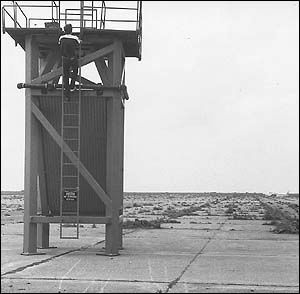
A circa 1981 photo of a Space Services Inc. employee climbing the Percheron rocket launch tower on the Matagorda Peninsula ramp.
After his 1982 retirement from NASA, astronaut Deke Slayton became president of Space Services Inc.,
a Houston-based company which used Matagorda Peninsula as a launch site for their commercial space rockets.
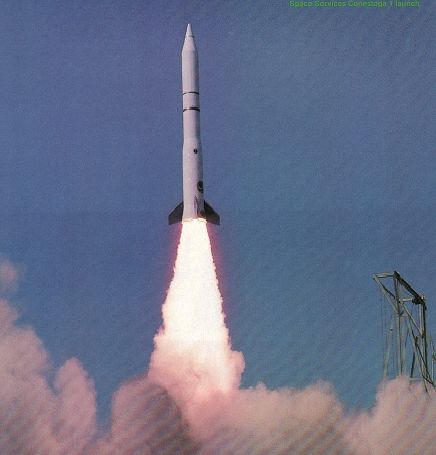
A 9/9/82 photo of the historic Conestoga rocket launch from Matagorda Peninsula -
the world's first privately funded mission to reach space.
No active airfield was listed at the site in the 1982 AOPA Airport Directory.
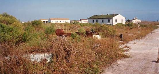
According to Bill Heddrick, “Pierce Field is owned by Aaron Pierce - His family has owned the facility since the mid-1980s.”
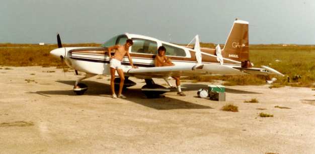
A 1984 photo by Frank Henderson of his friends in front of their Tiger,
after landing at the abandoned Matagorda Peninsula AAF.
He flew in "to spend the day on the beach.
It turned out to be one of the most enjoyable days of my life.
The airport was still very usable at the time,
although it may take an adventurous spirit to try landing there -
cowpatties & weeds were littering the surface."
He said that they had the beach to themselves - "Blue water, white sand... nice."
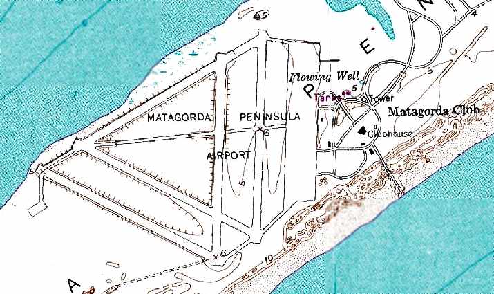
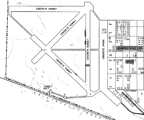
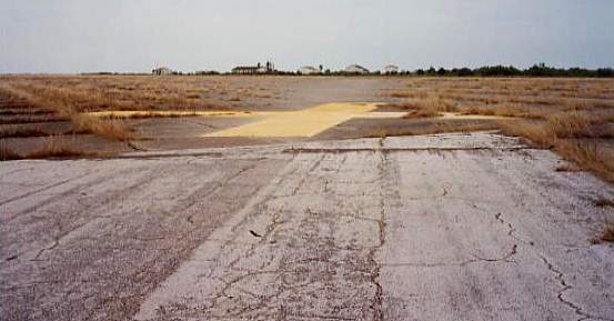
The 1989 USGS topo map depicted the “Matagorda Peninsula Airport”
as having a total of 5 paved runways, with a large paved ramp on the east side.
The property adjacent to the east side of the airfield was labeled as the “Matagorda Club”.
As seen in a 1995 USGS aerial view looking north, the former Matagorda Peninsula AAF includes 5 concrete runways, taxiways & a large ramp.
From at least 1998-2002, the airfield has been reused as a private airfield, Pierce Field.
Two runways were still maintained (the longest, 6/24, is 6,000').

The March 1999 Houston Sectional Chart (courtesy of Ron Plante) depicted Peirce Field as a private airfield having 2 paved runways,
with the longest being 6,000'.
A 2003 aerial view by Robert Laird looking northwest at several houses built on stilts over the western edge of the Pierce Field ramp.
Navy flight instructor Michael Strobach reported in 2003,
"I've flown over this field many times, and more than once I've seen Cessnas parked there.
The field looks in very bad shape, so whoever lands there is a true cowboy.
Today, I noticed a new-looking windsock."
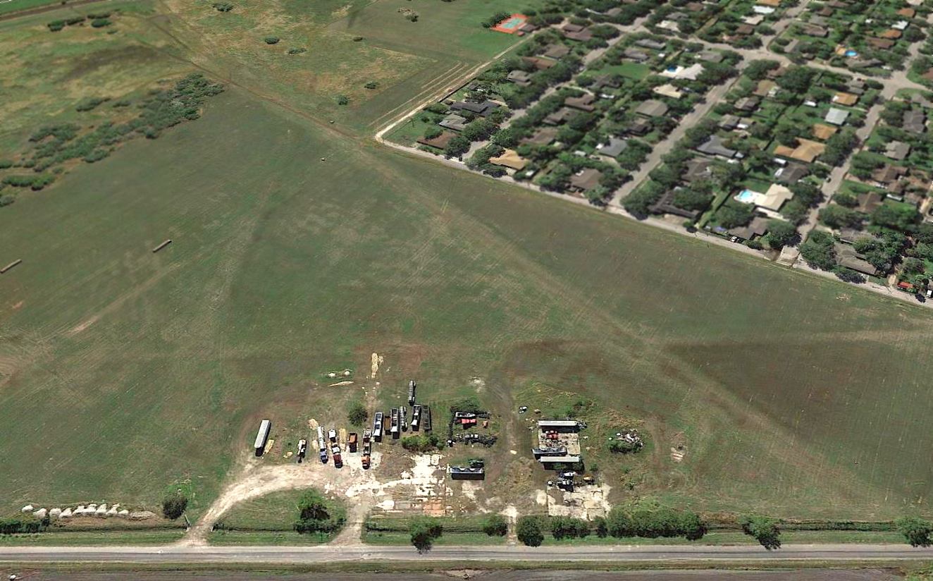
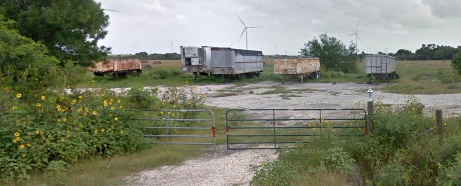
Hector Zuniga overflew Pierce Field in 2009, and reported, “Poor Pierce field, it seems that most of the runways & taxiways have been taken over by settlers or squatters
as structures that appear to be RVs & trailer homes are spaced out evenly among all of them.
Only the tarmac seems to be clear of them & in good shape, its concrete is nearly ash black with age however.
I saw no buildings in the way of hangars, towers, water towers or other 'military' looking structures left at all.
I could not even make up any of their possible bases or foundations.”
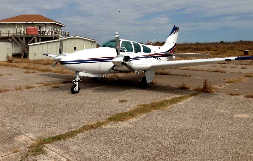
A 2012 photo by James Adams of his Beech Baron at Matagorda / Pierce Field.
James reported, “I landed there late last year. Privately owned but land owners are selling undivided interests in acreage.
The runways are quite overgrown but the main apron is in good shape - which is where most land.”
Bill Heddrick reported in 2015, “Pierce Field is owned by Aaron Pierce who lives in Kemah, TX.
It is a private facility & permission is required to land there.
Most people (with prior permission) land on the apron but he said one of the other runways is also in pretty good shape as well.”
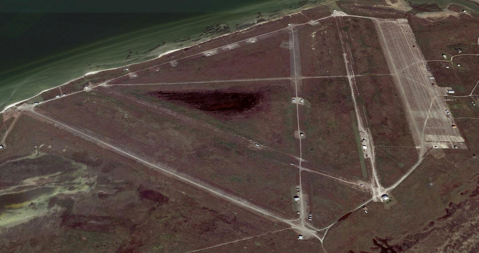
A 2018 aerial view looking north showed the remains of Pierce Field's 5 runways, taxiways & large ramp.
____________________________________________________
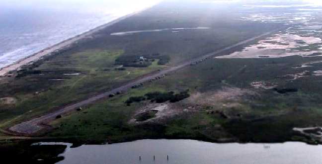
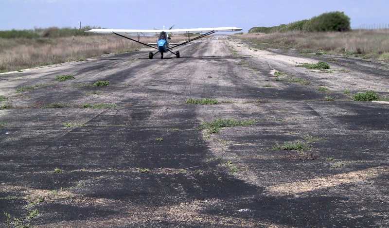
Matagorda Peninsula Airport (XS09), Matagorda Peninsula, TX
28.54, -96.12 (Northeast of Corpus Christi, TX)
Matagorda Peninsula Airport, as depicted on the 1964 San Antonio Sectional Chart (courtesy of Bill Suffa).
This airfield is located along a narrow island on the Gulf of Mexico.
Matagorda Peninsula Airport was apparently built at some point between 1961-64,
as it was not depicted at all on a 1943 aerial photo nor on the February 1961 San Antonio Sectional Chart.
The earliest depiction which has been located of Matagorda Peninsula Airport
was on the 1964 San Antonio Sectional Chart (courtesy of Bill Suffa).
It depicted Matagorda Peninsula as a private airfield with a single 3,000' asphalt runway.
The September 1970 Houston Sectional Chart (courtesy of Ron Plante) depicted Matagorda Peninsula Airport as a private airfield having a single 3,000' paved east/west runway.
The 1980 USGS topo map depicted Matagorda Peninsula Airport as a single east/west runway, labeled simply as “Landing Strip”.
Matagorda Peninsula was listed as a private airfield in the 1982 AOPA Airport Directory (courtesy of Ed Drury),
and it was described as having a single 5,100' asphalt Runway 8/26.
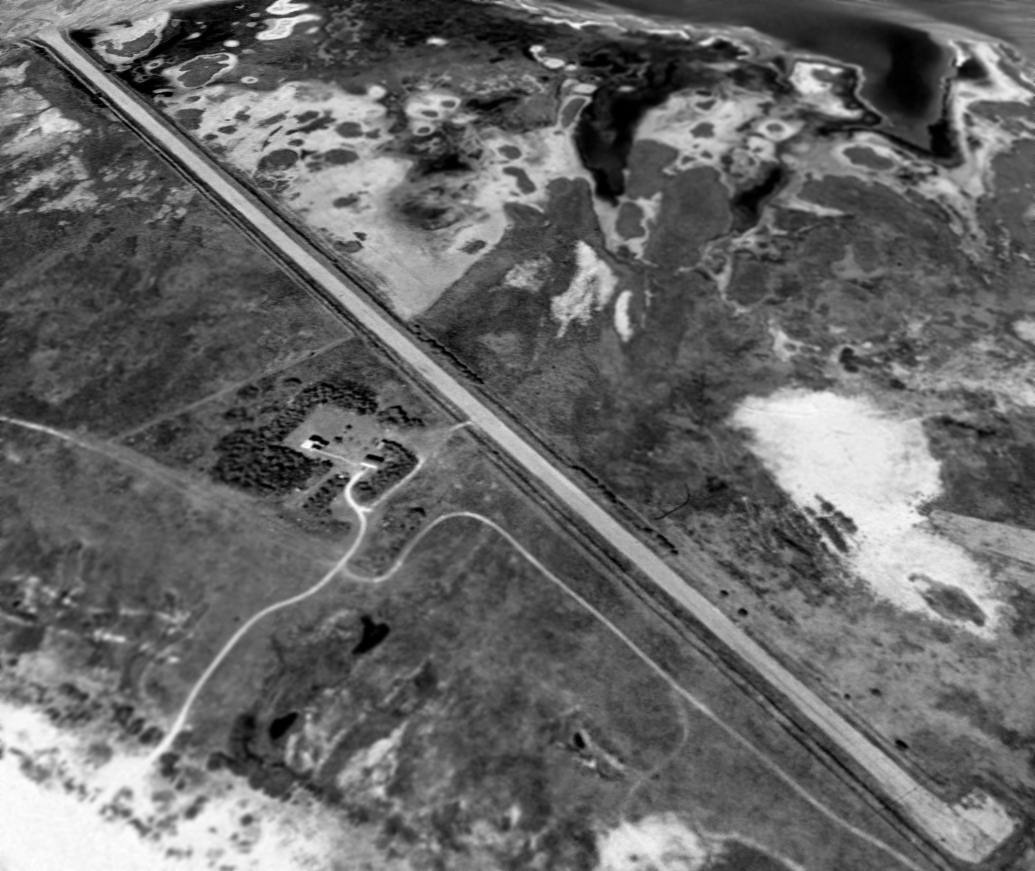
A 1995 USGS aerial view looking northwest showed Matagorda Peninsula Airport
to consist of a single 5,100' asphalt runway & a small ramp area with 2 small buildings.
According to George Horn (a TX state pilot), Matagorda Peninsula Airport (XS09) has been a private strip
owned by the Cullen family (a wealthy Houston oil family) for many decades.
Horn landed at Matagorda Peninsula in the late 1990s during acquisition talks.
Matagorda Peninsula Airport was depicted as an abandoned airfield on the March 1999 Houston Sectional Chart (courtesy of Ron Plante).
An April 2002 aerial view by Robert Laird looking southwest at Matagorda Peninsula Airport.
An April 2002 photo by Robert Laird of an ultralight after landing at Matagorda Peninsula Airport.
Navy flight instructor Michael Strobach reported in 2003,
"I flew over Matagorda Peninsula Airport. This field looks like it's in very good shape."
A 3/25/13 aerial view looking northwest showed the Matagorda Peninsula Airport to remain intact.
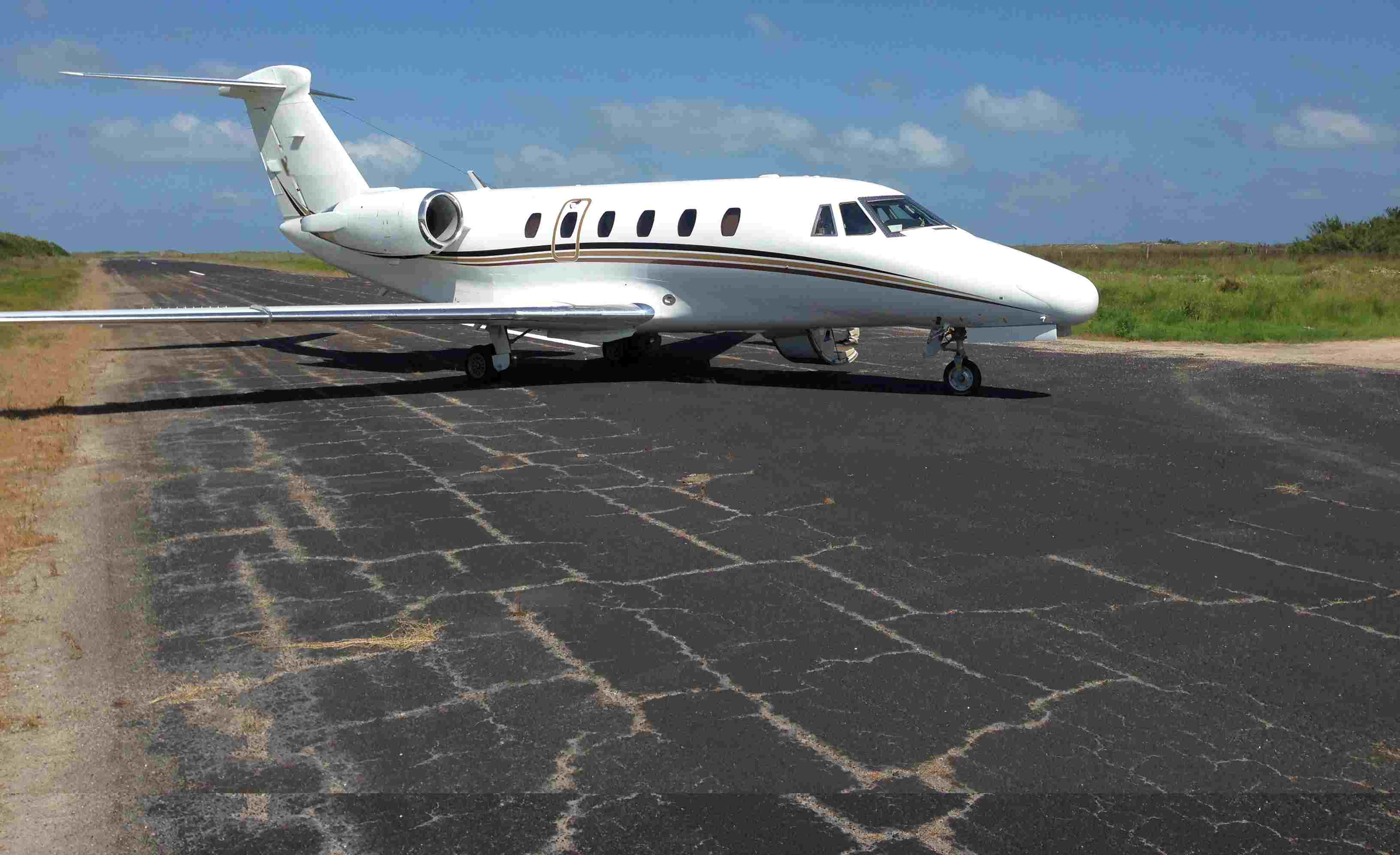
A 6/18/14 photo of a Cessna Citation VII on Matagorda Peninsula Airport.
A 1/15/15 aerial view by Trevor Mitchell looking southeast at Matagorda Peninsula Airport.
Trevor noted, “I noticed that the Matagorda Peninsula Airport had been recently repaved & given fresh markings.
It's still marked as abandoned on the sectional charts, however.”
A TX pilot reported in 2016 of Matagorda Island Airport, “It is privately owned & operated.”
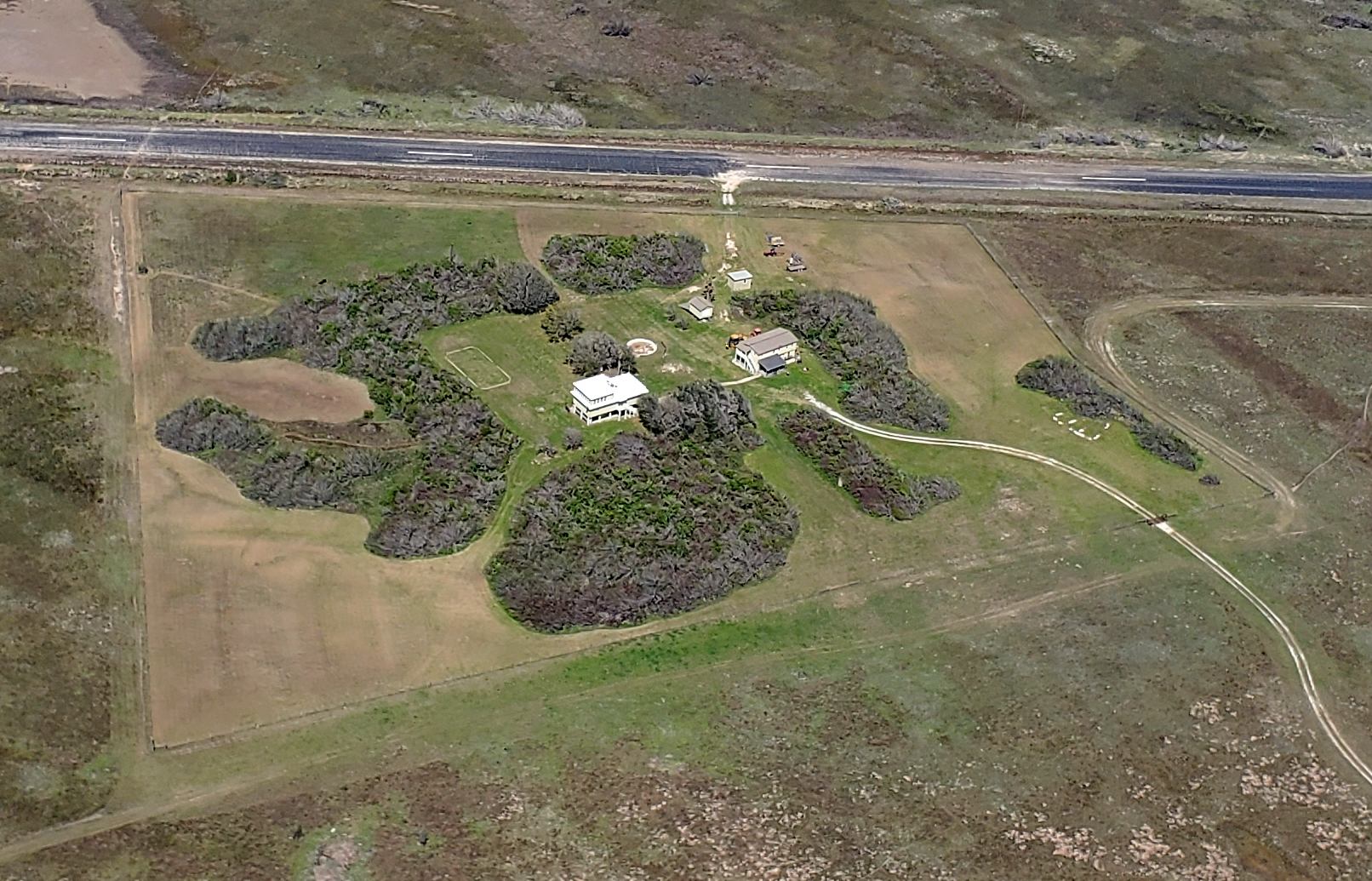
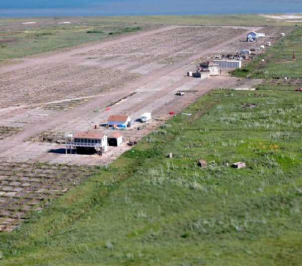
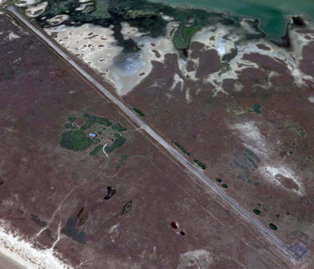
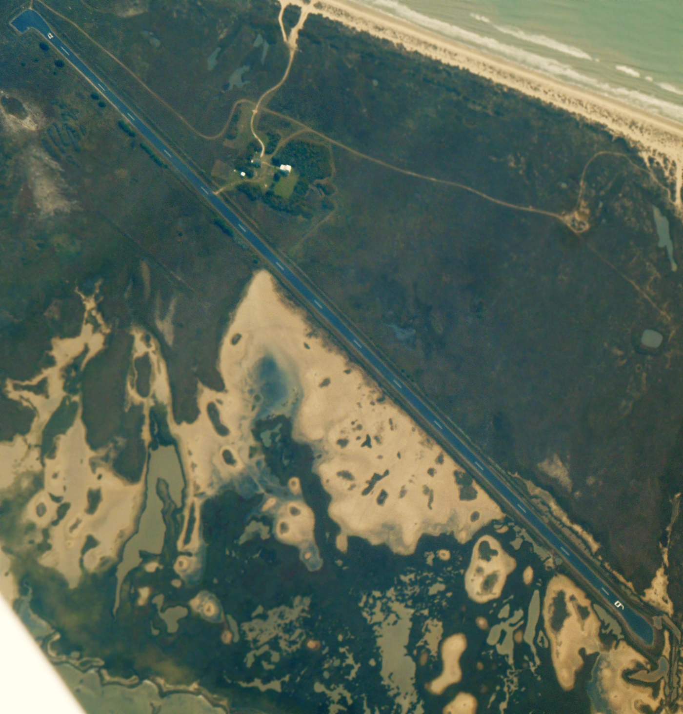
A 3/4/23 aerial view by Landon Kruse looking northeast at the buildings on the south side of Matagorda Peninsula Airport.
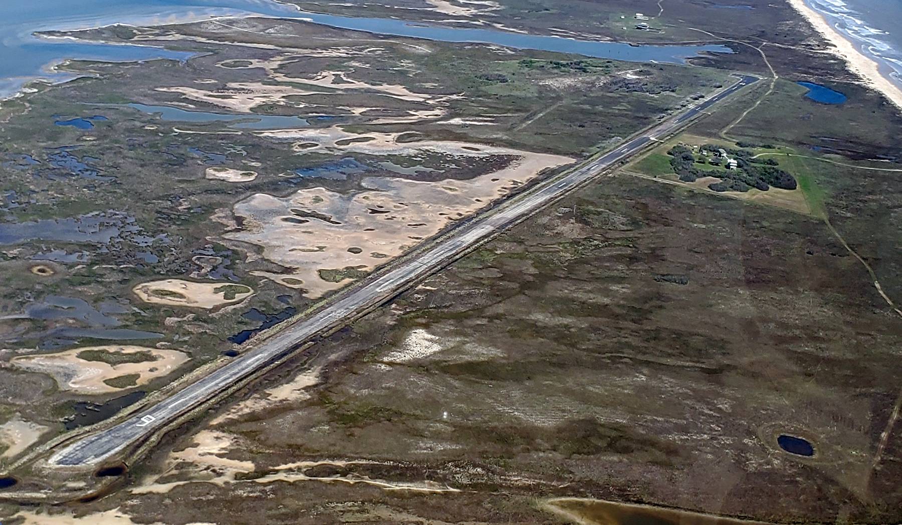
A 3/4/23 aerial view by Landon Kruse looking east at Matagorda Peninsula Airport.
____________________________________________________
Since this site was first put on the web in 1999, its popularity has grown tremendously.
If the total quantity of material on this site is to continue to grow,
it will require ever-increasing funding to pay its expenses.
Therefore, I request financial contributions from site visitors,
to help defray the increasing costs of the site
and ensure that it continues to be available & to grow.
What would you pay for a good aviation magazine, or a good aviation book?
Please consider a donation of an equivalent amount, at the least.
This site is not supported by commercial advertising –
it is purely supported by donations.
If you enjoy the site, and would like to make a financial contribution,
you
may use a credit card via
![]() :
:
Please consider checking the box to make a monthly donatation.
For a mailing address to send a check, please contact me at: paulandterryfreeman@gmail.com
If you enjoy this web site, please support it with a financial contribution.
please contact me at: paulandterryfreeman@gmail.com
If you enjoy this web site, please support it with a financial contribution.
____________________________________________________
This site covers airfields in all 50 states.