Abandoned & Little-Known Airfields:
New York State: Albany area
© 2002, © 2024 by Paul Freeman. Revised 1/13/24.
This site covers airfields in all 50 states: Click here for the site's main menu.
____________________________________________________
Please consider a financial contribution to support the continued growth & operation of this site.
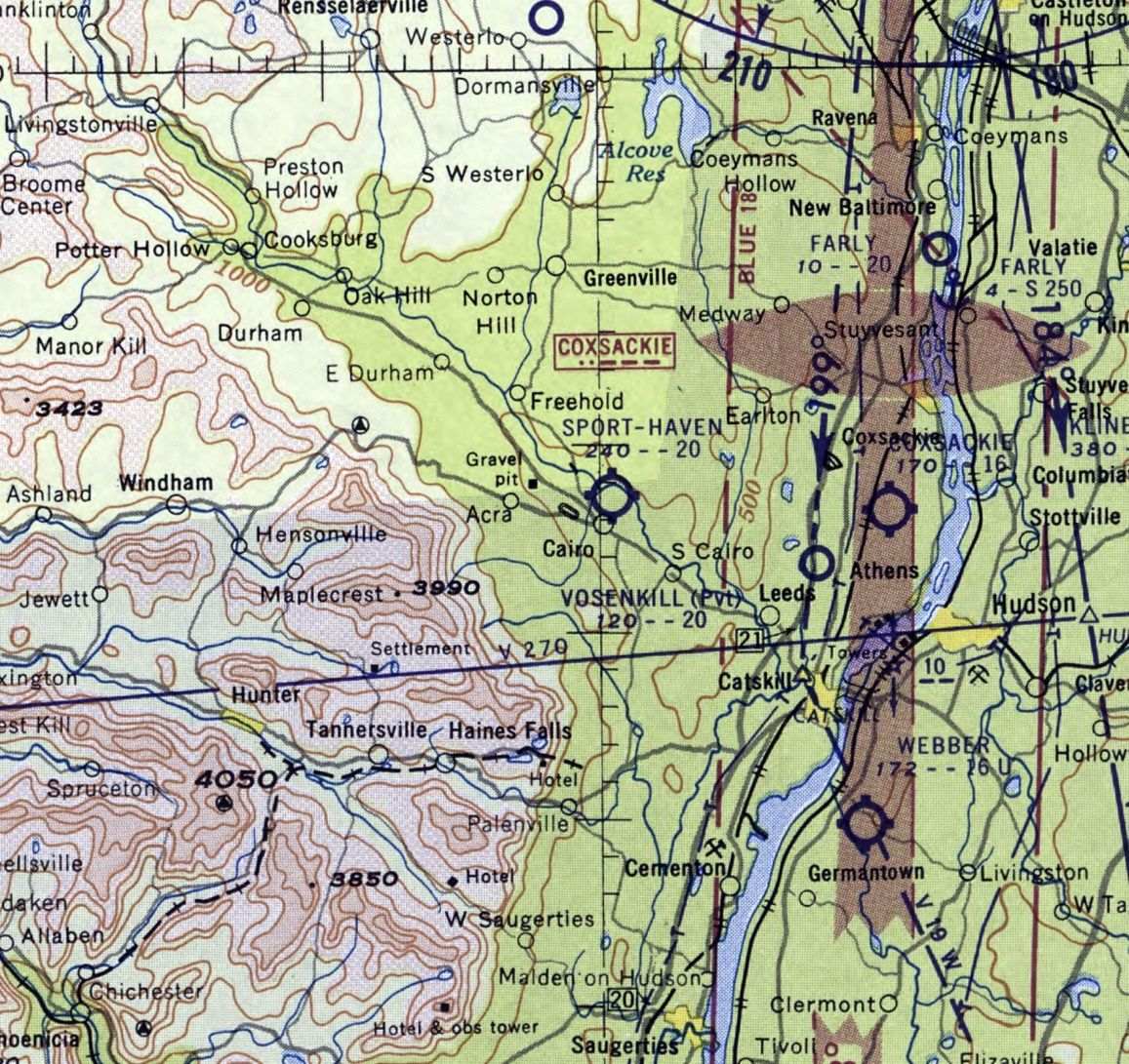
Catskill Airport / Catskill Valley Airport (revised 6/15/19) - East Greenbush Airport (revised 10/13/18) - Farlys Airpark / Farley's Air Park / Farly Airpark (revised 4/14/18)
Glens Falls Airport / (Original) Floyd Bennett Field (revised 5/29/17) - Keyes Oneonta Airport (revised 10/31/22)
Kingston Airways Airport / Kingston Auxiliary Field / Kingston Airport (revised 1/13/24)
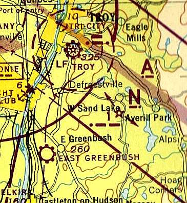
Loudon Airport (revised 5/29/17) - Sport Haven Airport (revised 1/17/17) - Troy Airport (revised 6/27/22) - Westerlo Airport (revised 1/13/24)
____________________________________________________
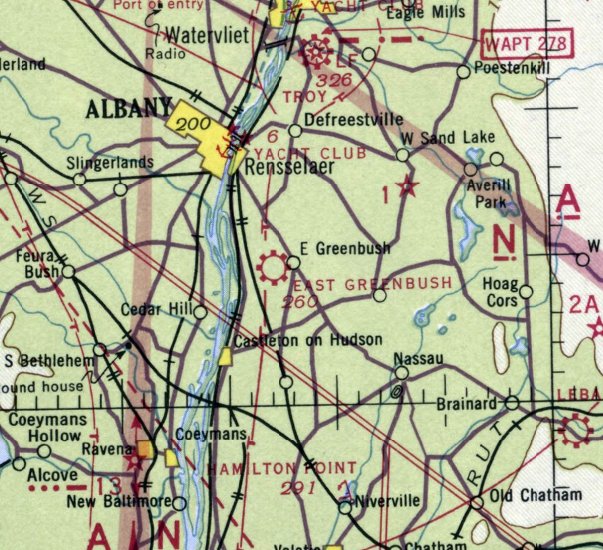
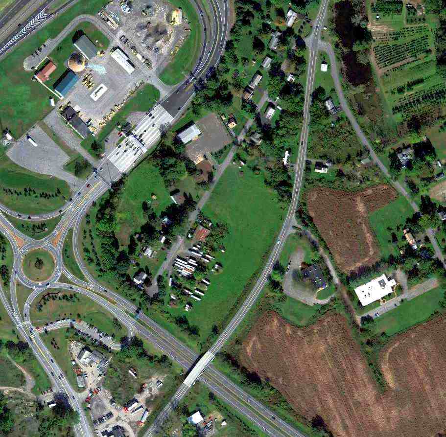
Westerlo Airport, Westerlo, NY
42.521, -74.029 (South of Albany, NY)
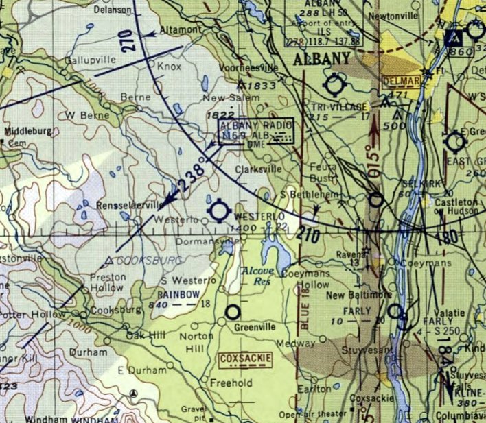
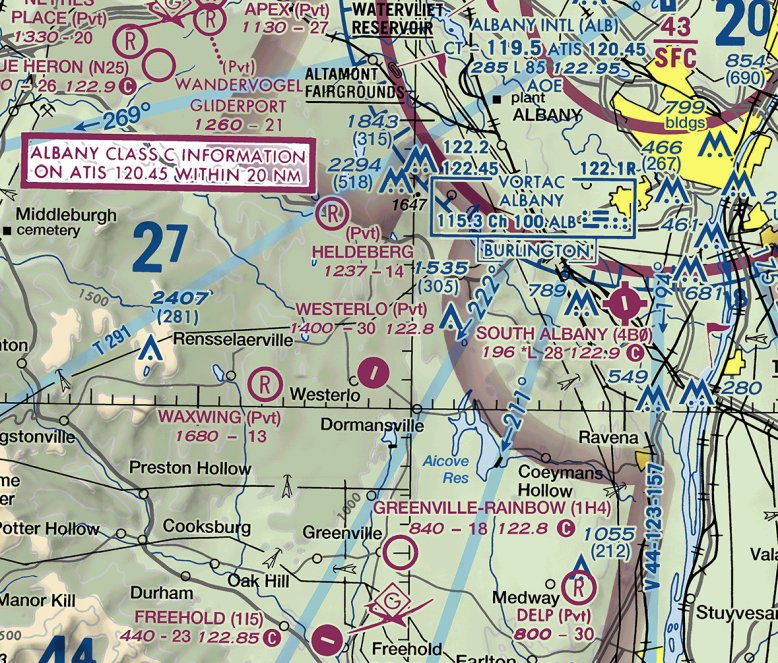
Westerlo Airport, as depicted on the November 1955 Albany Sectional Chart.
This small general aviation airport was evidently established at some point in 1955,
as it was not yet depicted on a 1952 aerial photo nor on the May 1955 Albany Sectional Chart.
The earliest depiction which has been located of Westerlo Airport was on the November 1955 Albany Sectional Chart.
It depicted Westerlo Airport as having a 2,200' unpaved runway.
The January 1973 Albany Sectional Chart (courtesy of Ron Plante) depicted Westerlo Airport as having a 3,000' unpaved runway.
The earliest photo which has been located of Westerlo Airport was a 1986 aerial view.
It depicted Westerlo Airport as having a single asphalt northeast/southwest runway, with 1 hangar on the northeast side.
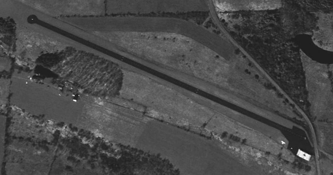
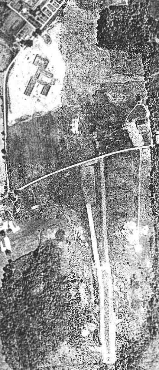
The earliest photo which is available of Westerlo Airport was a 1995 USGS aerial view looking southwest.
It depicted Westerlo Airport as having a single asphalt northeast/southwest runway, with 1 light plane & 1 hangar on the northeast side.
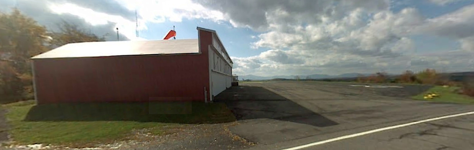
The last photo which has been located showing an aircraft at Westerlo Airport was a 2007 photo looking south.
One light single-engine plane was visible parked on the ramp south of the hangar.
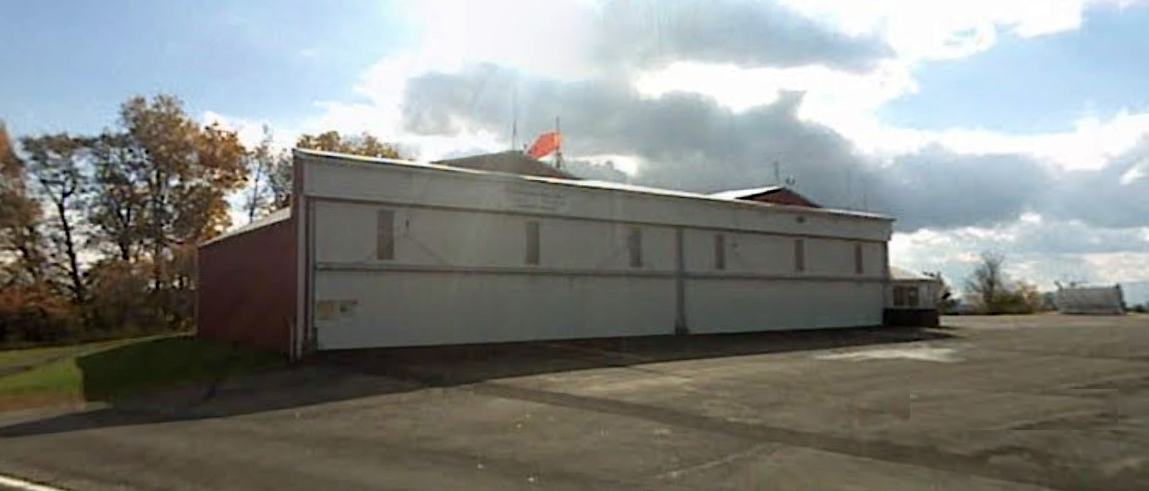
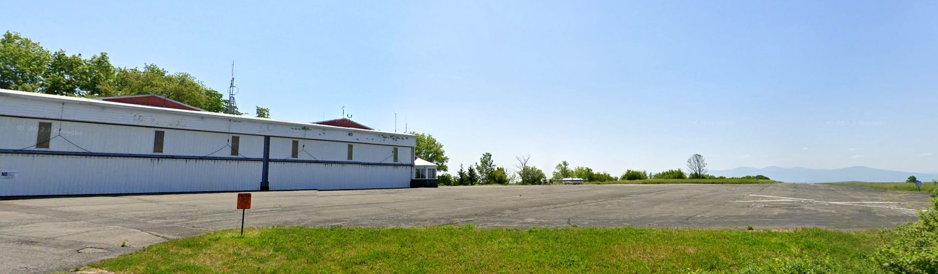
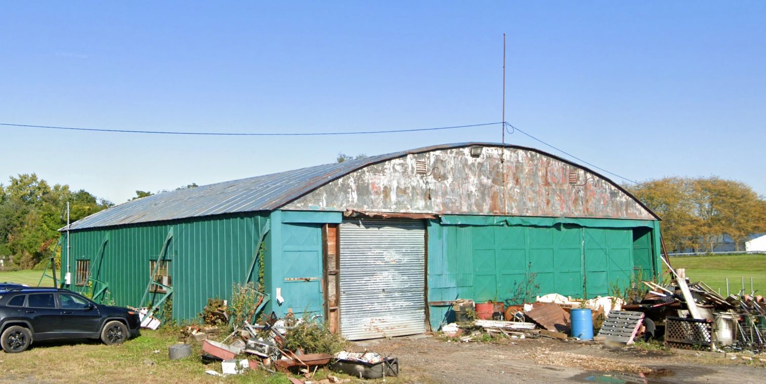
A 2007 photo looking southeast at the Westerlo Airport hangar.
The last aeronautical chart depiction which has been located of Westerlo Airport was on the April 2016 NY Sectional Chart (courtesy of Ron Plante).
It depicted Westerlo Airport as a private airfield having a 3,000' paved northeast/southwest runway.
Westerlo Airport was evidently closed at some point between 2016-2017,
as it was depicted as an abandoned airfield on the 2017 NY Sectional Chart (courtesy of Ron Plante).
Robert Cook recalled, “Westerlo Airport closed when the owner passed away & his family had no interest in it. The owner was the owner of Hanney reel company.”
A 2022 aerial view by Robert Cook looking east at the Westerlo Airport hangar.
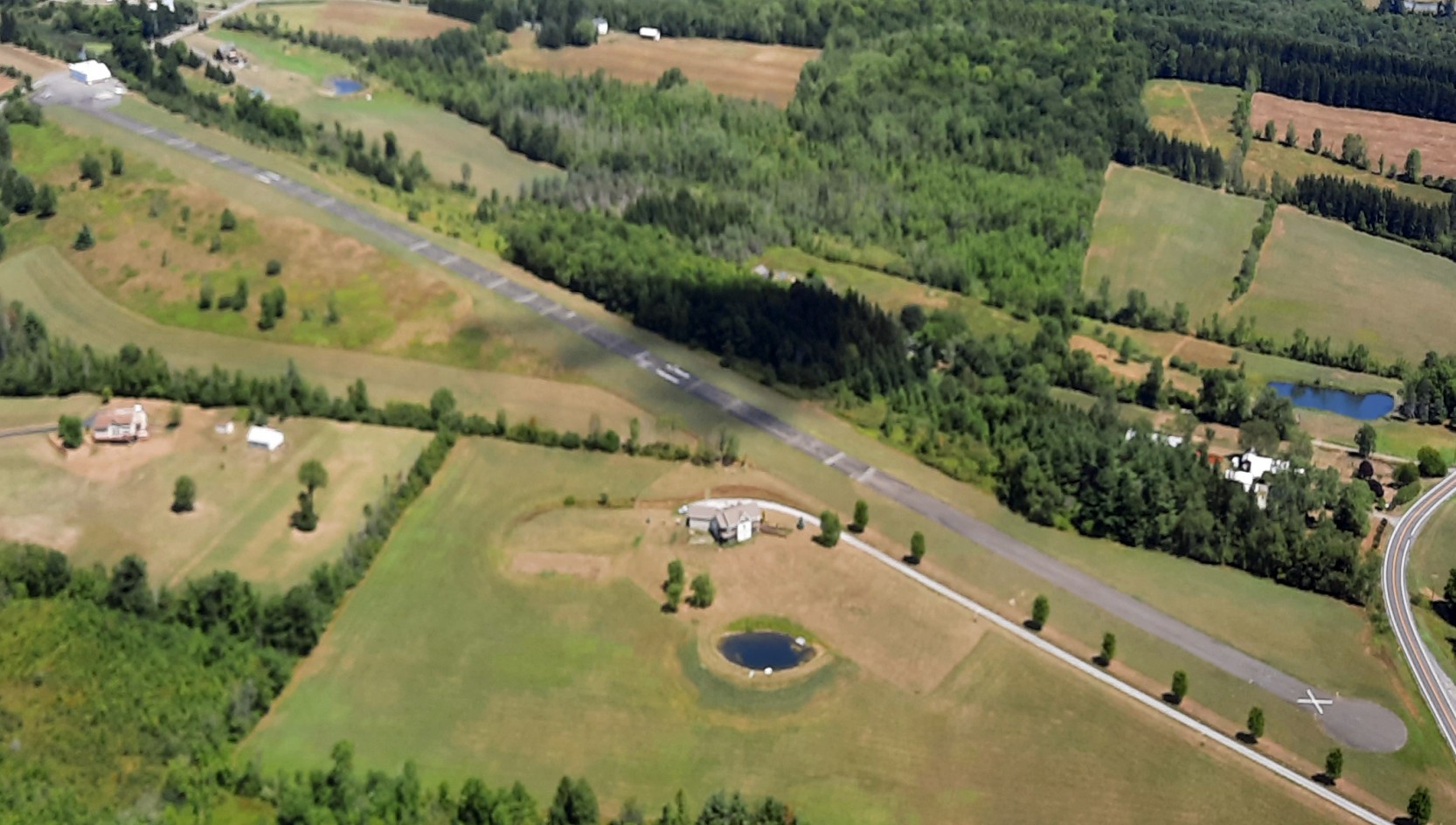
A 2022 aerial view by Robert Cook looking northeast at Westerlo Airport.
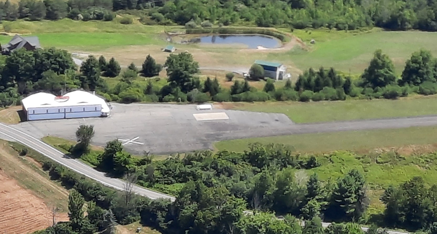
A 2022 aerial view by Robert Cook looking north at Westerlo Airport.
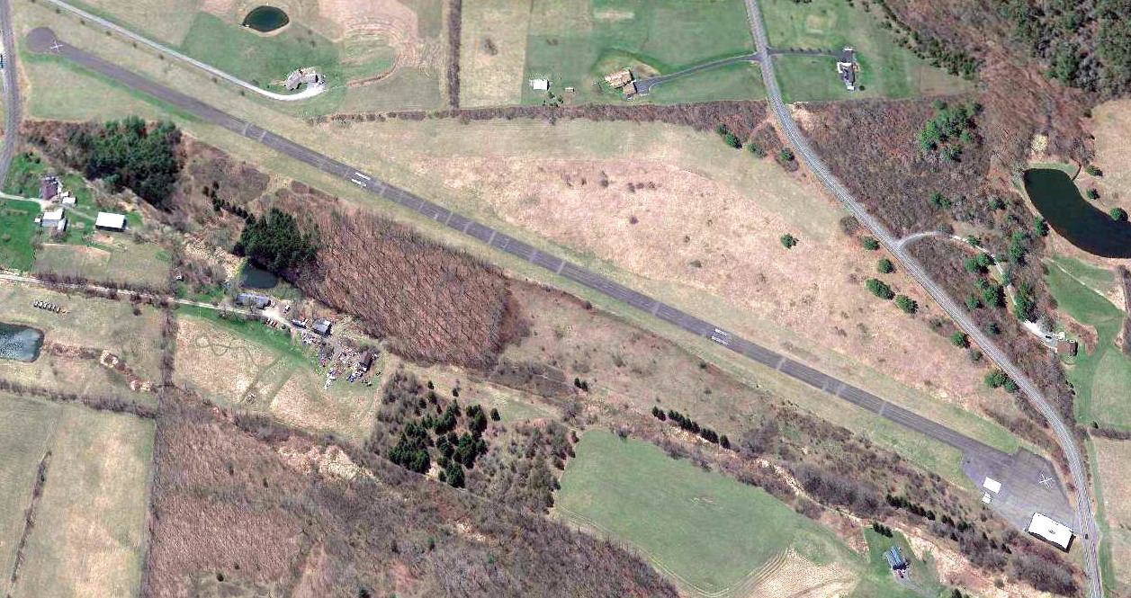
A 2022 aerial view looking southwest at Westerlo Airport.
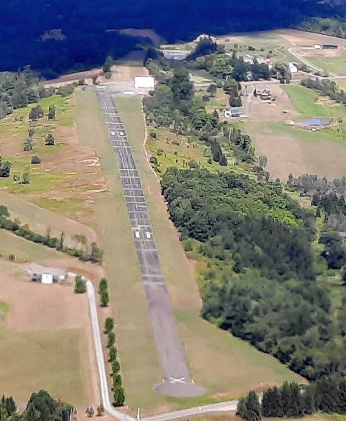
A 2023 photo looking south at the Westerlo Airport hangar & runway marked with a white closed-runway “X” symbol.
Thanks to Robert Cook for pointing out this airfield.
____________________________________________________
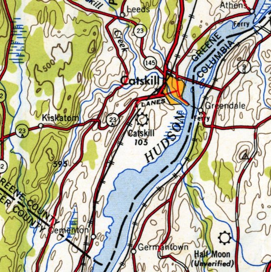
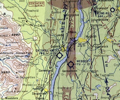
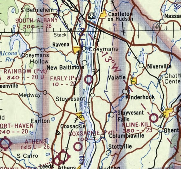
Catskill Airport / Catskill Valley Airport, Catskill, NY
42.197, -73.888 (South of Albany, NY)
Catskill Valley Airport, as depicted on the July 1946 Albany Sectional Chart.
This small general aviation airport was evidently established at some point between 1945-46 (like hundreds of other small American airports in the post-WW2 general aviation boom),
as it was not yet depicted on the November 1945 Albany Sectional Chart.
The earliest depiction which has been located of Catskill Valley Airport was on the July 1946 Albany Sectional Chart.
It depicted Catskill Valley as a commercial/municipal airport.
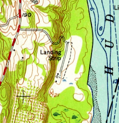
The 1948 USGS topo map depicted it simply as “Catskill” Airport.
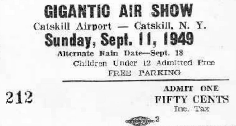
An advertisement for a 9/11/49 “Gigantic Air Show” at Catskill Airport (courtesy of Marc Cramer).
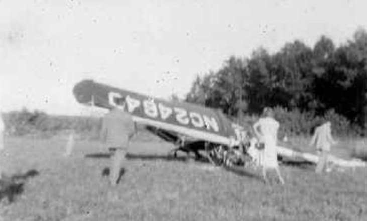
A 9/11/49 photo captioned “Catskill Airshow disaster” (courtesy of Marc Cramer), showing the wreckage of an unidentified light single-engine aircraft.
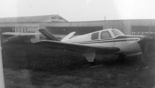
A 1950 photo of a V-tail Beechcraft Bonanza in front of hangars at Catskill Airport (courtesy of Dave DiBiase).
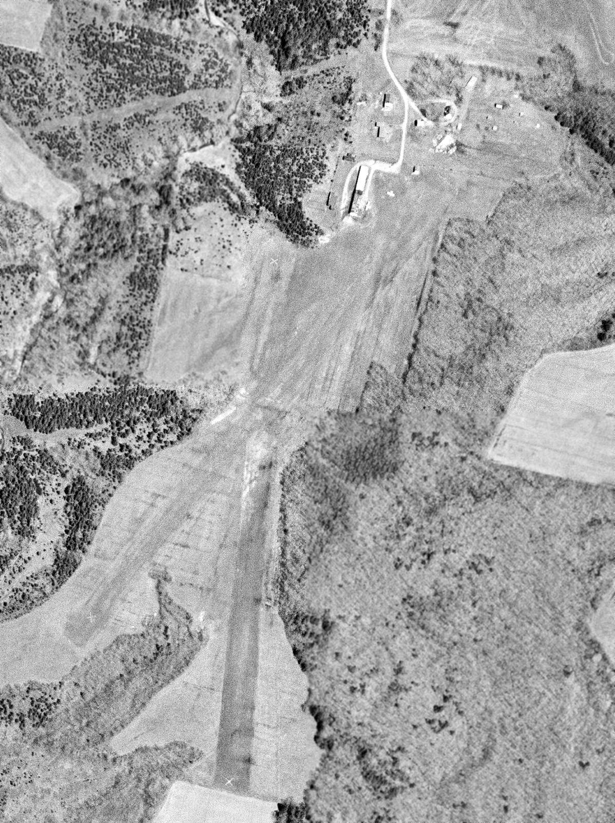
The last photo which has been located showing Catskill Valley Airport in operation was a 5/1/56 USGS aerial view.
It depicted Catskill Valley as having 2 grass runways (each marked with closed-runway “X” symbols),
yet 2 light single-engine aircraft were parked near a few small hangars on the north end.
The last aeronautical chart depiction which has been located of Catskill Valley Airport was on the May 1957 NY Sectional Chart (courtesy of Ron Plante).
It depicted Catskill Valley as having a 2,600' unpaved runway.
Catskill Valley Airport was evidently closed (for reasons unknown) at some point between 1957-60,
as it was no longer depicted on the May 1960 Albany Sectional Chart.
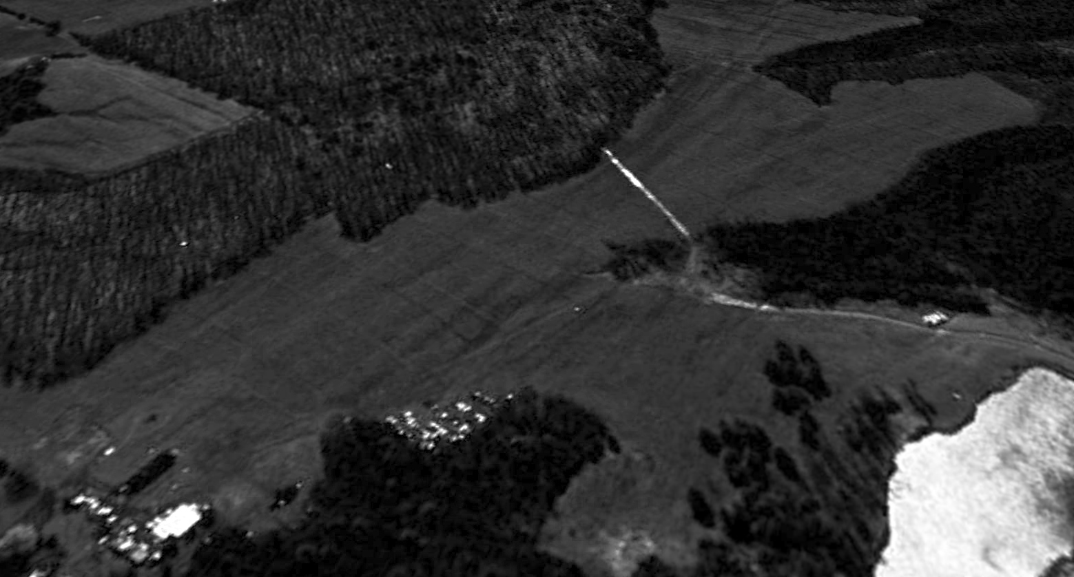
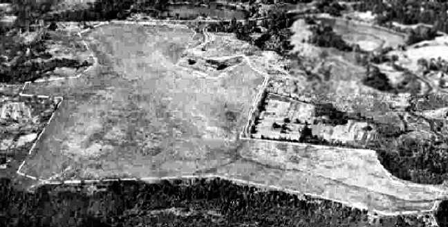
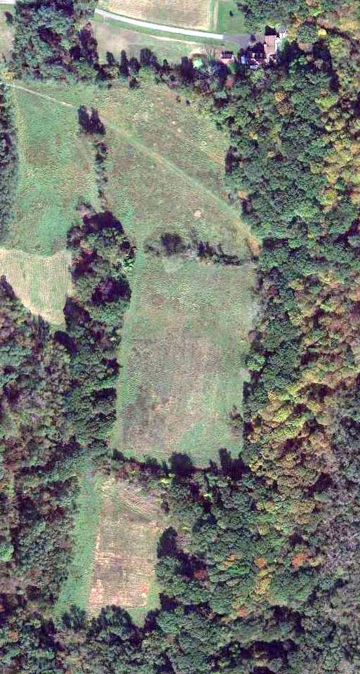
A 1994 aerial view looking south at the site of Catskill Valley Airport showed the property remained clear, and the hangars remained intact, but the runways were no longer recognizable.
A 2013 aerial view showed crops had been planted on the middle of the former Catskill Valley Airport runway.
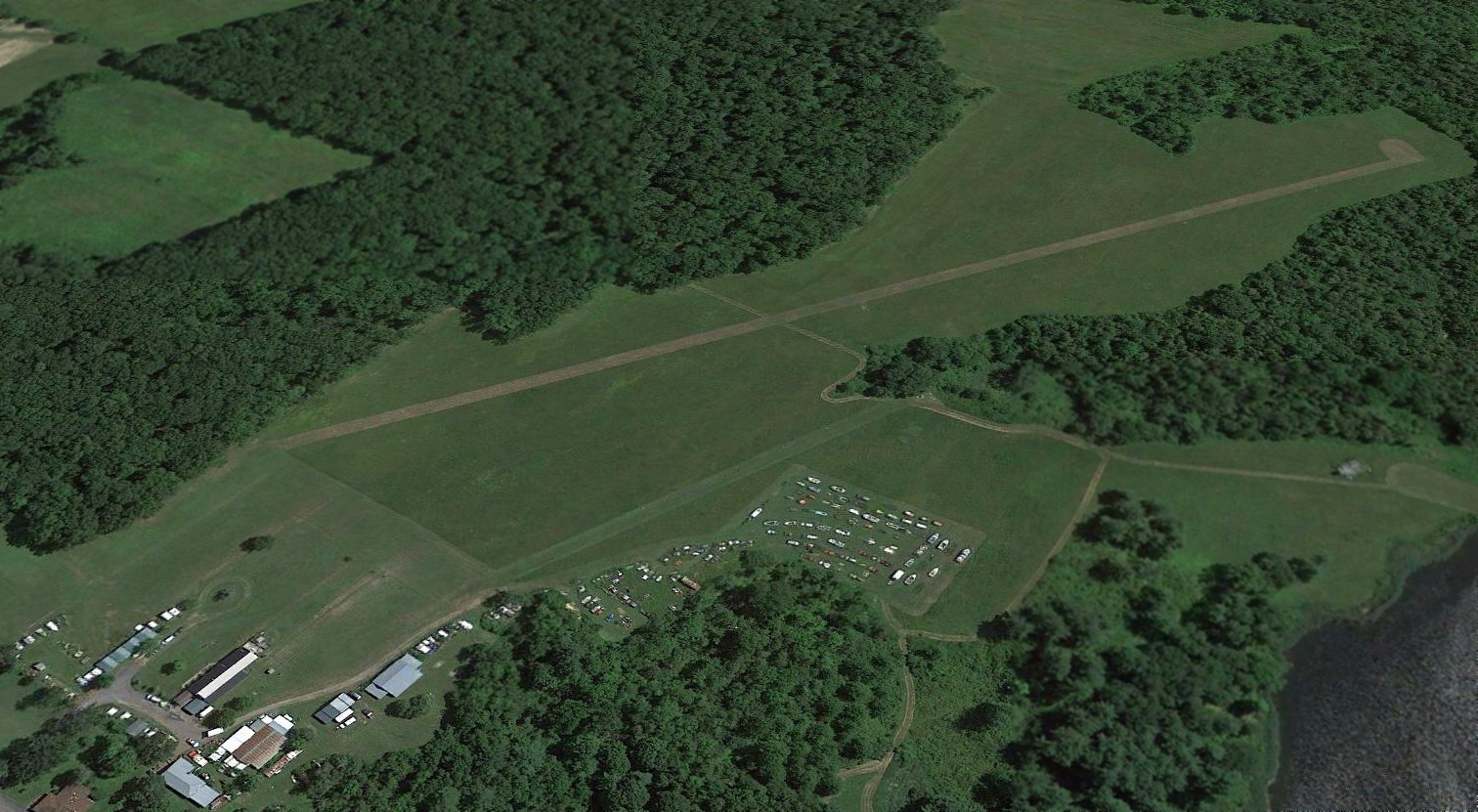
A 2015 aerial view looking south at the site of Catskill Valley Airport showed what appeared to be a new runway was established at some point between 2013-2015,
so it is possible the airport has a new lease on life.
A 2023 aerial photo of Catskill Airport no longer showed the runway seen in the 2015 photo.
The site of Catskill Airport is located at the southern terminus of Landon Avenue.
Thanks to Marc Cramker for pointing out this airfield.
____________________________________________________
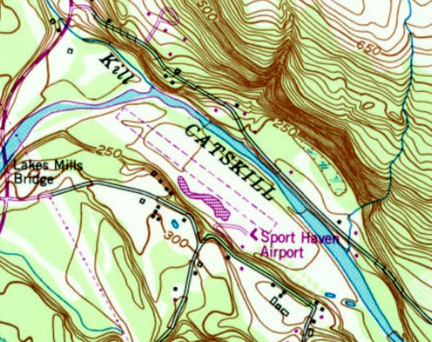
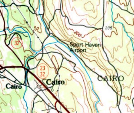
Sport Haven Airport, Cairo, NY
42.314, -73.986 (Southwest of Albany, NY)
Sport Haven Airport, as depicted on the May 1960 Albany Sectional Chart.
Photo of airport while in use has not been located.
This small general aviation airport was evidently established at some point between 1957-60,
as it was not yet depicted on a 1952 aerial photo nor on the May 1957 Albany Sectional Chart.
The earliest depiction which has been located of Sport Haven Airport was on the May 1960 Albany Sectional Chart.
It depicted Sport Haven as having a 2,000' unpaved runway.
The last May 1970 Albany Sectional Chart depicted Sport Haven Airport's runway length had increased slightly to 2,600'.
Ted Sandomenico recalled, “In 1971 my friends & I camped at Creekside Campgrounds (Sport Haven Airport).
It was owned by a nice couple named Al & Patty.”
The 1980 USGS topo map depicted Sport Haven Airport as having an unpaved northwest/southeast runway,
with one small building on the south side.

The last aeronautical chart depiction which has been located of Sport Haven Airport was on the June 1981 NY Sectional Chart (courtesy of Ron Plante).
The earliest photo which has been located of Sport Haven Airport was a 1985 aerial view.
It depicted a single unpaved northwest/southeast runway, with a small building on the southeast side.
Ted Sandomenico recalled, “Around the mid- to late-1980s Al [Sport Haven Airport owner] was killed in a plane crash & the campground [& presumably the airport] was closed.”
According to NTSB records, this crash was on 5/26/86.
The last depiction which has been located of Sport Haven Airport was on the 1989 USGS topo map.
Sport Haven Airport was no longer depicted on the December 1993 NY Sectional Chart (courtesy of Ron Plante).
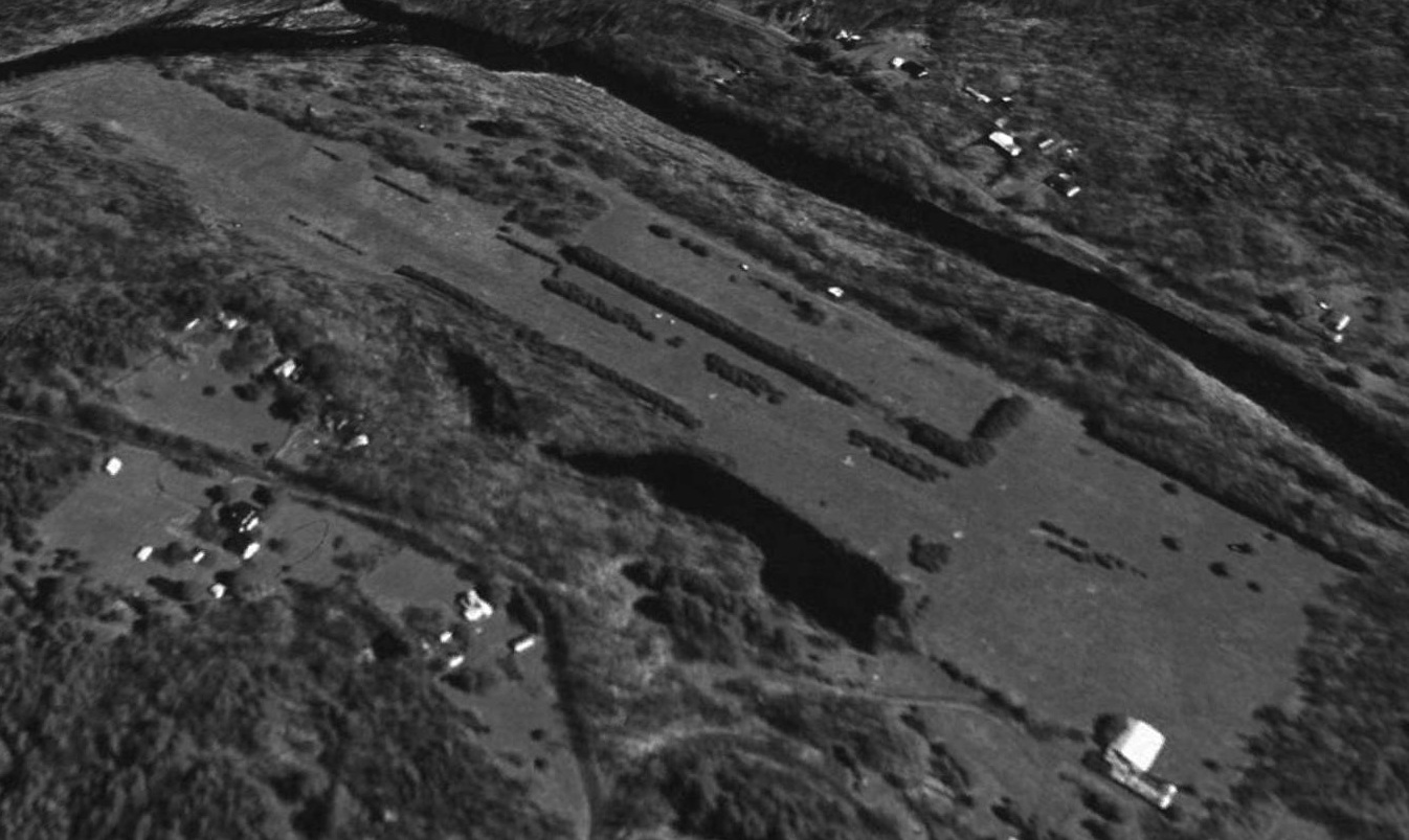
The earliest photo which has been located of Sport Haven Airport was a 1995 USGS aerial view looking north.
It depicted Sport Haven Airport as having a grass northwest/southeast runway, with one small building (hangar?) on the south side.
A 2015 aerial view looking north at the site of Sport Haven Airport showed that crops had been planted on the southeast half of the runway.
The site of Sport Haven Airport is located at the end of Abandoned Airport Road – pretty clever, eh?
____________________________________________________
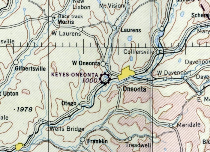
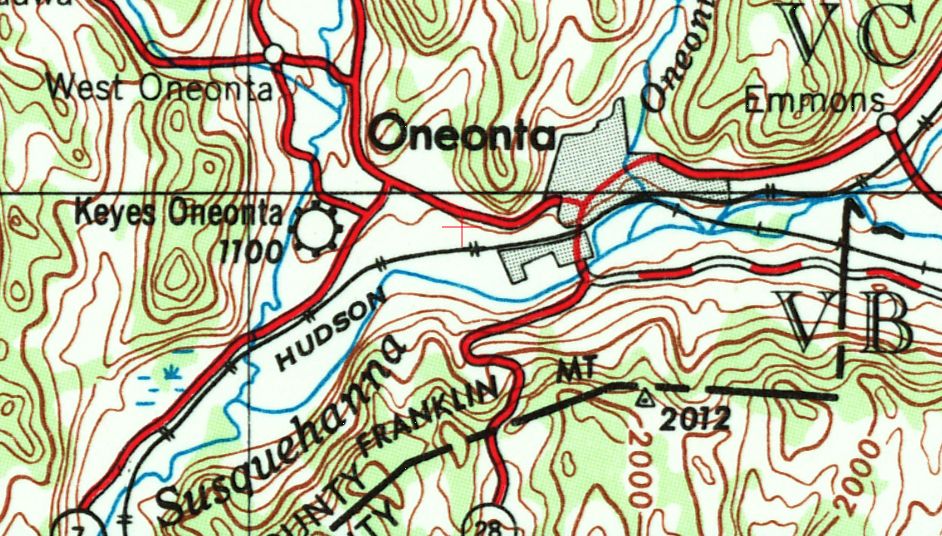
Keyes Oneonta Airport, Oneonta, NY
42.451, -75.109 (Southwest of Albany, NY)
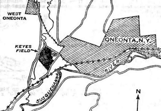
Keyes Field, as depicted on the 7/24/30 Commerce Department Airway Bulletin (courtesy of Mike Denja).
According to “Images of America: Oneonta”, D.F. Keyes built 3 runways on 190 acres of land.
According to “Oneonta” by Gene Milener, “D.F. Keyes converted part of the Oneonta Union Agricultural Society's land at the Oneonta Plains to a landing strip.
The first flight from Keyes' Airport was on 5/1/27.”
The earliest depiction which has been located of Keyes Airport was on the 7/24/30 Commerce Department Airway Bulletin (courtesy of Mike Denja).
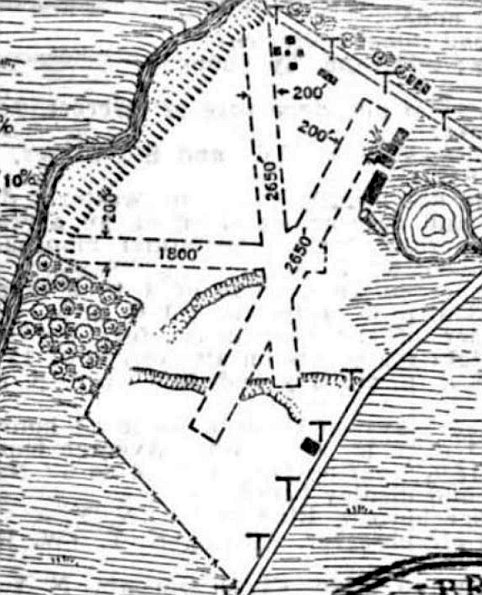
The 7/24/30 Commerce Department Airway Bulletin (courtesy of Mike Denja) described Keyes Field as a commercial airport
owned by Keyes Oneonta Field Inc. & operated by Carlton Hinman.
It was said to consist of a 200 acre rectangular gravel field, having 3 runways, the longest measuring 2,650' north/south & northeast/southwest.
Several buildings were depicted on the northeast side.

The earliest aeronautical chart depiction which has been located of Keyes Airport was on the June 1933 Albany Sectional Chart (courtesy of Mike Denja).
It depicted Keyes Airport as a commercial/municipal airport.
Keyes Airport may have been temporarily closed during WW2 (like many other small civilian airports near the coasts),
as it was not depicted on the July 1942 Albany Sectional Chart.
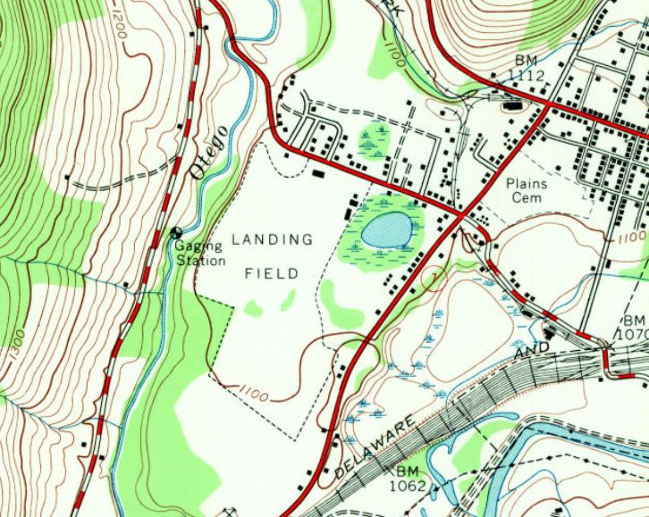
The earliest topo map depiction which has been located of Keyes Oneonta Airport was on the 1943 USGS topo map,
which depicted an irregularly-shaped property outline on the west side of the town, labeled simply as “Landing Field”.
The 1945 USGS topo map depicted Keyes Airport in an unchanged fashion.
The May 1945 Albany Sectional Chart depicted Keyes-Oneonta as a commercial/municipal airport.
The 1948 USGS topo map depicted Keyes Oneonta Airport as a commercial/municipal airport.
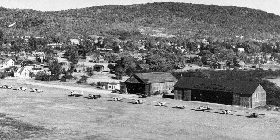
The only photo which has been located of Keyes-Oneonta Airport was a circa 1948 postcard photo (courtesy of Andreas Svrakov).
It depicted 13 light single-engine aircraft parked in front of 2 wooden hangars, on the edge of a grass airfield.

The last aeronautical chart depiction which has been located of Oneonta Airport was on the May 1955 Albany Sectional Chart.
It depicted Oneonta Airport as having a 2,600' unpaved runway.
Keyes Oneonta Airport was evidently closed (for reasons unknown) at some point between 1955-57,
as it was no longer depicted on the May 1957 Albany Sectional Chart.
According to “Images of America: Oneonta”, Oneonta Airport operated until D.F. Keyes sold the acreage to NYSEG in 1960.
A 5/4/60 USGS aerial view was presumably taken after Keyes Oneonta Airport had closed.
It depicted an open grass field, with possibly 2 unpaved runways, and some small buildings on the north side.
The 1963 USGS topo map continued to depict Keyes Oneonta Airport in an unchanged fashion.
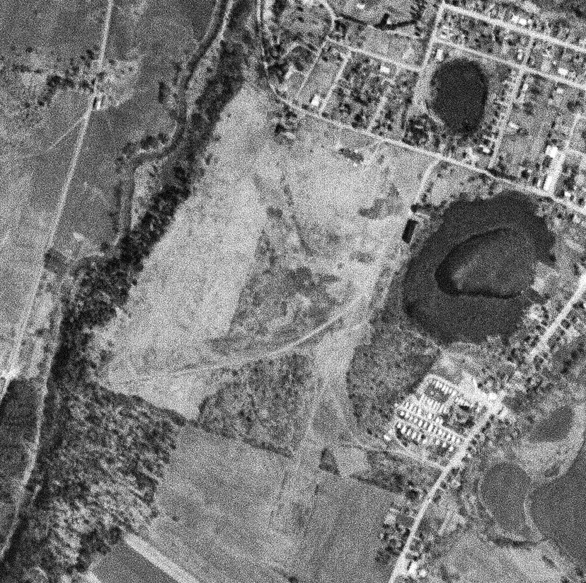
The 1982 USGS topo map showed several buildings had been built on the site of Keyes Oneonta Airport.
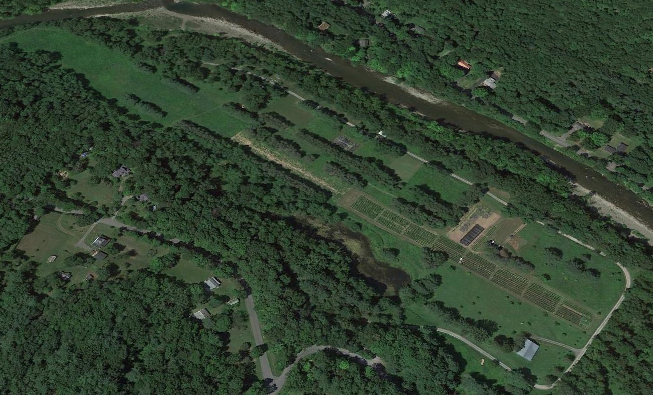
A 1997 aerial photo showed no recognizable trace remaining of Keyes Oneonta Airport.
A 2015 aerial photo showed no recognizable trace remaining of Keyes Oneonta Airport.
The site of Keyes Oneonta Airport is located south of the intersection of Country Club Road & Brown Street.
____________________________________________________
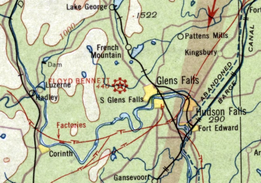
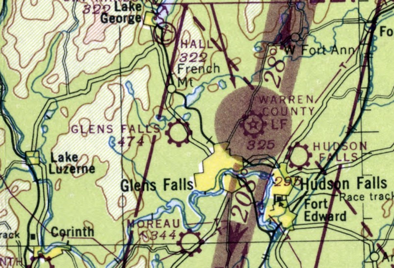
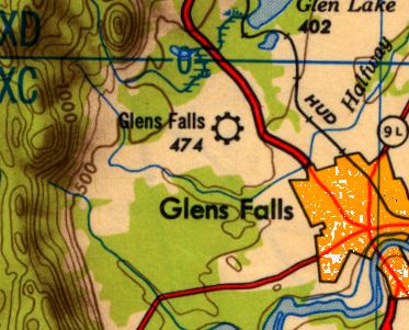
Glens Falls Airport / (Original) Floyd Bennett Field, Glens Falls, NY
43.332, -73.692 (Northeast of Albany, NY)
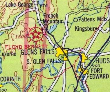
Floyd Bennett Field, as depicted on a 1930 Airways Chart (courtesy of Brian).
The original airport for the town of Glens Falls was located on the northwest side of the town.
According to Brian, “The original airport was opened in 1918.
It was built on Miller Hill (named for the Millers, a local family).
It was dedicated to Floyd Bennett in 1928. Floyd Bennett was a local boy.”
The earliest depiction which has been located of Floyd Bennett Field was on a 1930 Airways Chart (courtesy of Brian).
Confusingly, in 1930 a much better-known “Floyd Bennett Field” was established in New York City.
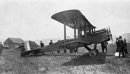
An undated photo of an unidentified biplane at Glens Falls Floyd Bennett Field (courtesy of Brian).
Floyd Bennett Field, as depicted on the June 1933 Albany Sectional Chart.
Brian recalled, “My Uncle Johnny…. was taking lessons before he went into the Army [1942]
and, of course, was learning at the old airport.
He had soloed but hadn't finished his license when he entered the service. His flight instructor was a man named Pop Pease.
When Mom told me that, I had a vague recollection of having heard the name before.
At the next Glens Falls Pilots Association meeting, I went up to the oldest member there & asked if he knew Pop Pease?
'Oh, sure, I knew Pop! He was a great guy! He'd been a Marine sergeant & he was a helluva pilot & a helluva teacher but he sure was a taskmaster!'”

The earliest aerial photo which has been located Floyd Bennett Field was a 9/29/42 USGS aerial view.
It depicted Floyd Bennett as having 3 asphalt runways, and an asphalt taxiway leading to a hangar on the southeast side, with one single-engine aircraft parked on the ramp.
A larger Floyd Bennett Field was built to the northeast of Glens Falls was built in 1946,
but the original field evidently remained open for at least another year.
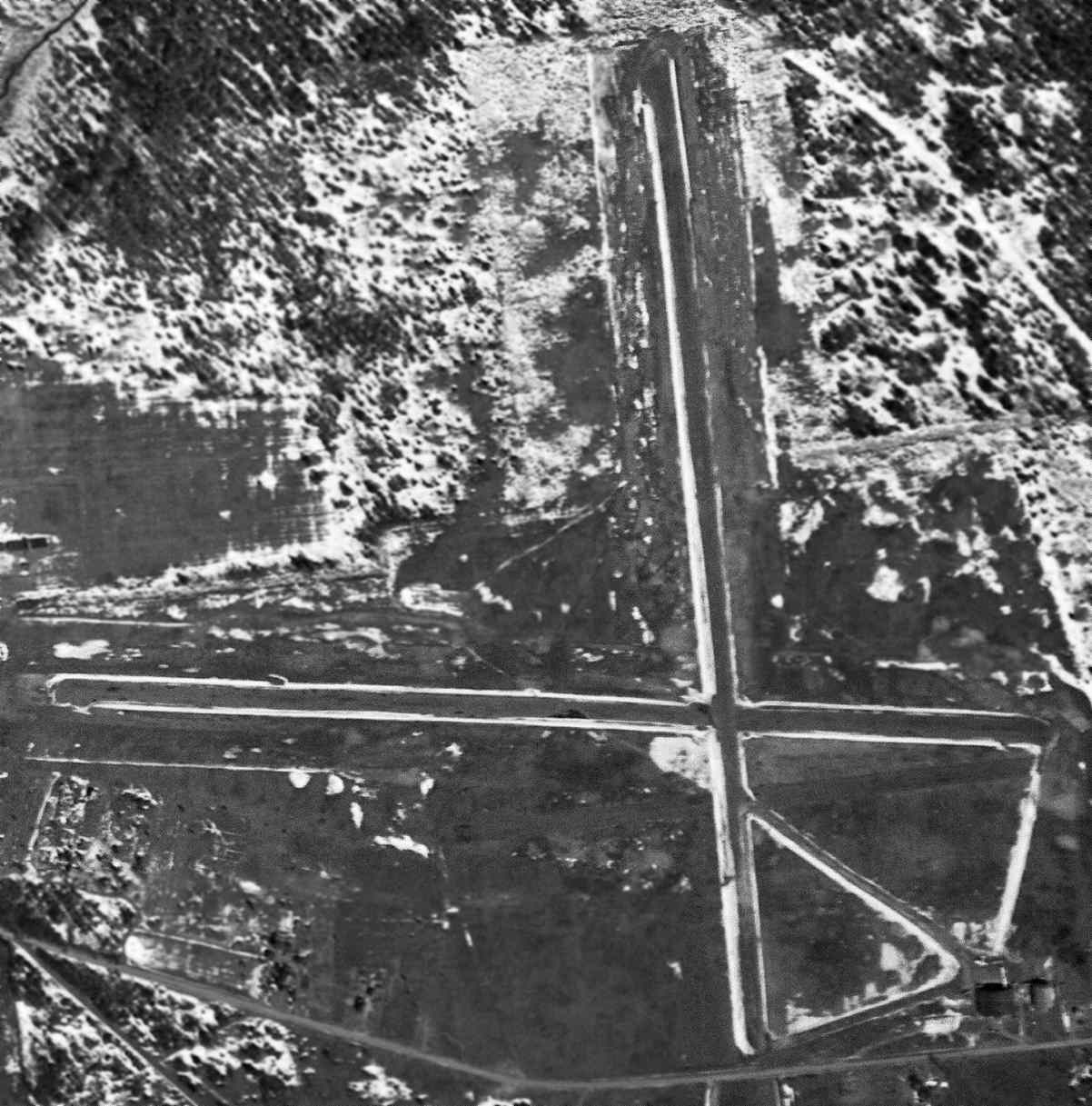
The last depiction which has been located showing Floyd Bennett Field in operation was a 4/3/47 USGS aerial view.
A second building (another hangar?) had been added at some point between 1942-47,
and 1 aircraft was visible parked outside the hangar on the southeast side.
The last aeronautical chart depiction which has been located of the original Glens Falls Airport in operation was on the January 1948 Albany Sectional Chart.
The airport was still depicted, labeled “Glens Falls”, on the 1950 USGS topo map.
According to a member of the Glens Falls Pilots Association, upon the closure of the original Glens Falls Airport,
several of its hangars were relocated to the current Glens Falls Airport.
The original Glens Falls Airport / Floyd Bennett Field was evidently closed at some point between 1947-50,
as it was no longer depicted on the January 1950 Albany Sectional Chart.

The original Glens Falls Airport / Floyd Bennett Field was labeled “Airport (Abandoned)” on the 1955 USGS topo map.
The 3 runways were still depicted, but Queensbury High School had been on the site of the hangars, to the southwest of the runways.
Brian recalled, “As a child in the 1950s, I have vague memories of my mother taking all 5 of us kids up to that airport to watch small planes.
My mother & my older sister & brother confirm this.
It would have been around 1957, I think, so there must have been at least some activity still going on even if the airport was technically abandoned.”
The last photo which has been located showing Floyd Bennett Field's runways still remaining mostly intact was a 4/29/65 USGS aerial view.
A replacement Queensbury High School had been built to the southwest of the runways,
and the school on the southeast part of the airport site had become Queensbury Middle School.
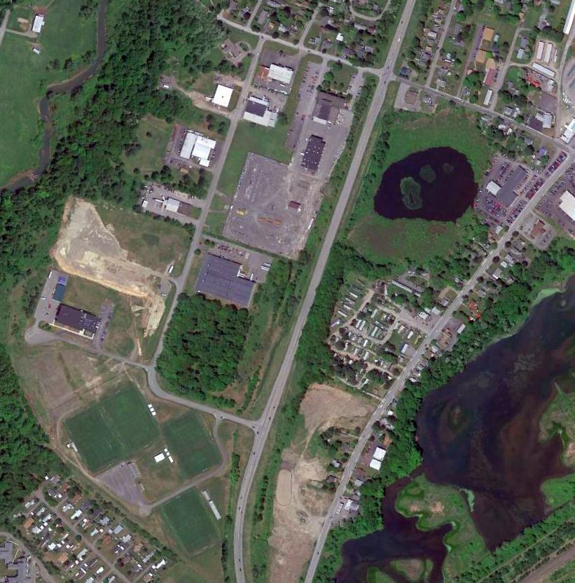
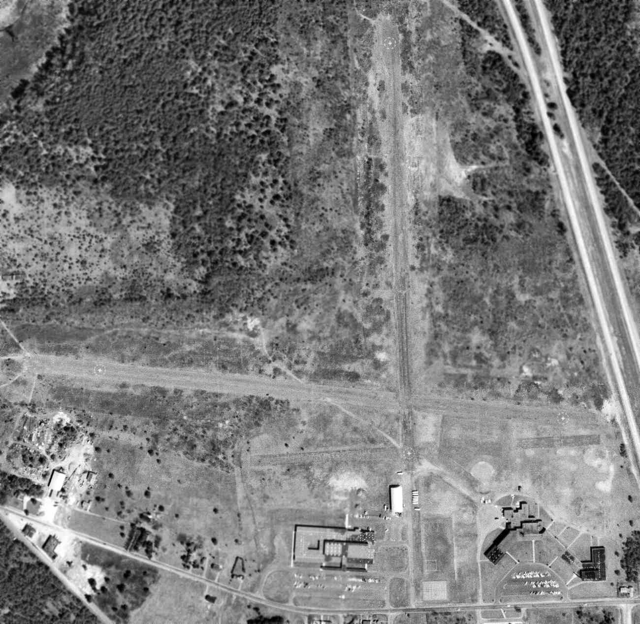
A 2004 aerial view showed that school athletic fields had covered almost all of the airfield site,
with only a small clearing still remaining of the outline of the western portion of the east/west runway.
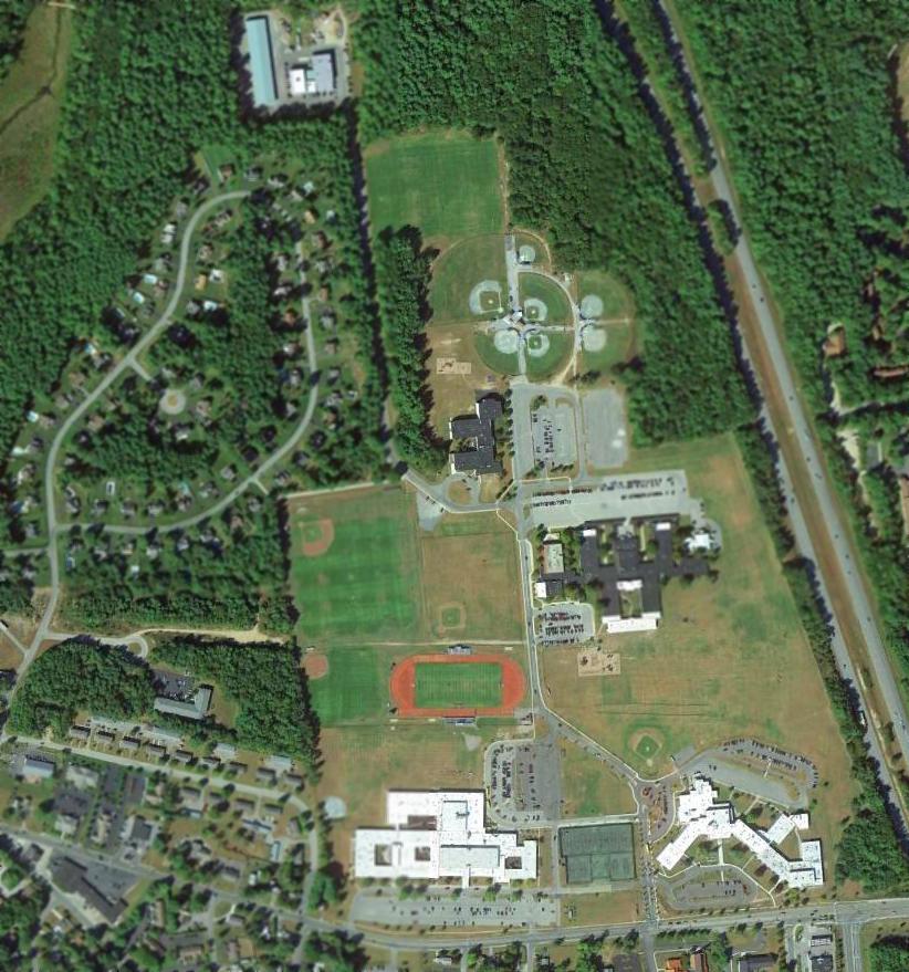
A 2013 aerial photo showed the only trace remaining of the original Floyd Bennett Field was a small clearing of the outline of the western portion of the east/west runway.
Brian reported in 2015, “The site is now the Queensbury school.
If you go out back of the school, you can still cuts in the trees made for the runway, almost 70 years after it closed.”
The site of the original Floyd Bennett Field is located northwest of the intersection of Interstate 87 & Aviation Road, appropriately enough.
Thanks to Brian for pointing out this airfield.
____________________________________________________
42.798, -73.728 (Northeast of Albany, NY)
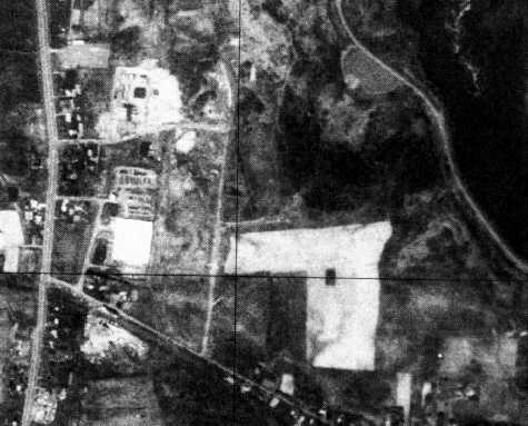
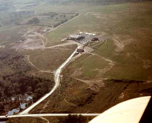
A 4/16/52 USGS aerial view of Loudon Airport.
Much of the following material about Loudon Airport comes from Ed Chevrette, whose book “Wings of Fortune” describes the field in great detail.
Loudon Airport was not yet depicted on the 1949 USGS topo map.
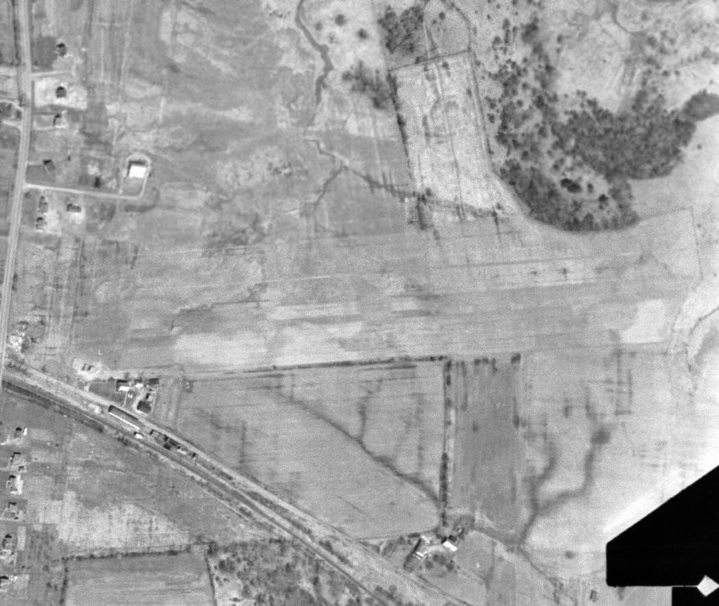
The earliest depiction which has been located of Loudon Airport was a 4/16/52 USGS aerial photo,
which depicted the field as having 2 perpendicular grass runways, with several small buildings on the southwest & south sides.
According to Ed Chevrette, “Loudon Airport... was officially opened in 1954.”
Loudon Airport was not yet depicted on the 1956 USGS topo map or the May 1957 Albany Sectional Chart.
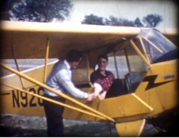
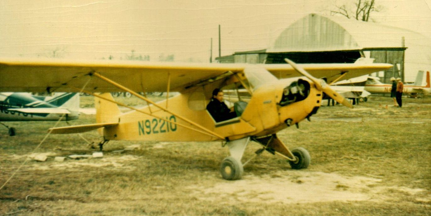
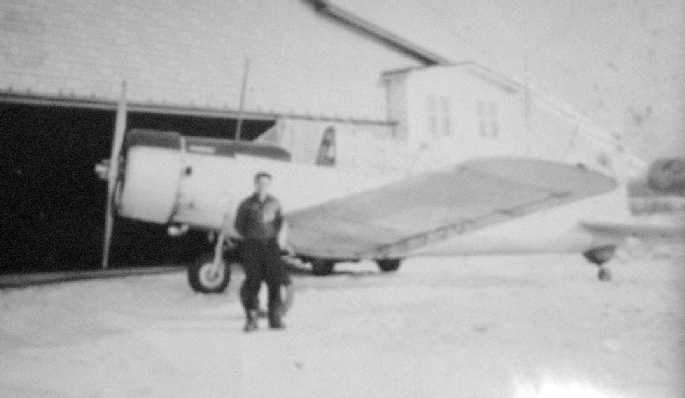
A 9/20/59 photo of Ed Chevrette being congratulated by his flight instructor on the occasion of his 1st solo flight, in a Piper Cub at Loudon Airport.
The photo is on the cover of Ed's book “Wings of Fortune”.

Another 9/20/59 photo of Ed Chevrette taxiing a Piper Cub at Loudon Airport for his 1st solo flight.
The earliest aeronautical chart depiction which has been located of Loudon Airport was on the May 1960 Albany Sectional Chart.
It depicted Loudon as having a 2,200' unpaved runway.
Jim Thayer recalled, “I soloed a Cessna 172 in 1961 at Loudon Airport. I knew well the guys there - Ed Chevrette was my instructor for a bit.
Don Harrigan owned the place & Len Alexander was my usual instructor.”
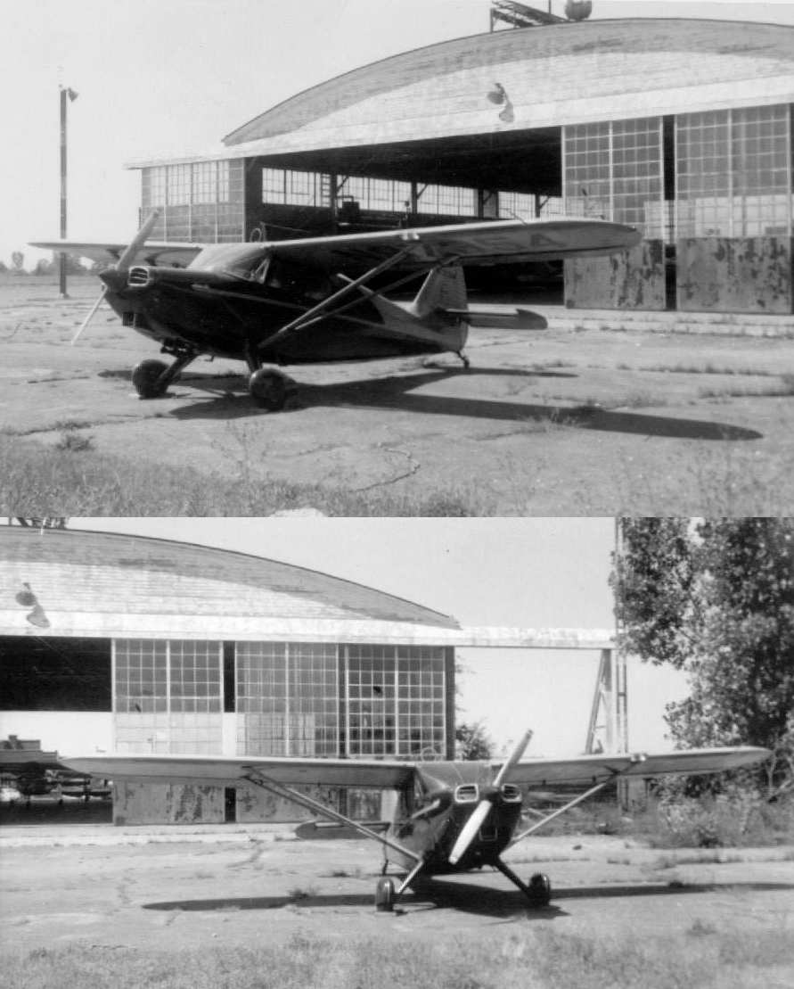
The last photo which has been located showing Loudon Airport in operation was a Fall 1964 photo by Ed Chevrette of a Piper Cub,
which Ed recalled was “one of the Cubs I flew out of Loudon Airport. I took my Private Flight Test in this one.
The young pilot inside is one of the pilots I was reunited with after reading my book. We had the same Flight Instructor.”
The last aeronautical chart depiction which has been located of Loudon Airport was on the July 1965 Albany Sectional Chart.
It depicted Loudon as having a 2,100' unpaved runway.
Loudon Airport was not depicted on the 1965 USGS topo map.
Loudon Airport was no longer depicted on the July 1968 Albany Sectional Chart.
According to Ed Chevrette, “Loudon Airport... was closed in 1969.”
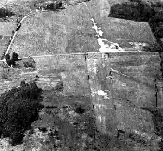
A 1978 aerial photo depicted the site of Loudon Airport with a road going across the western portion.
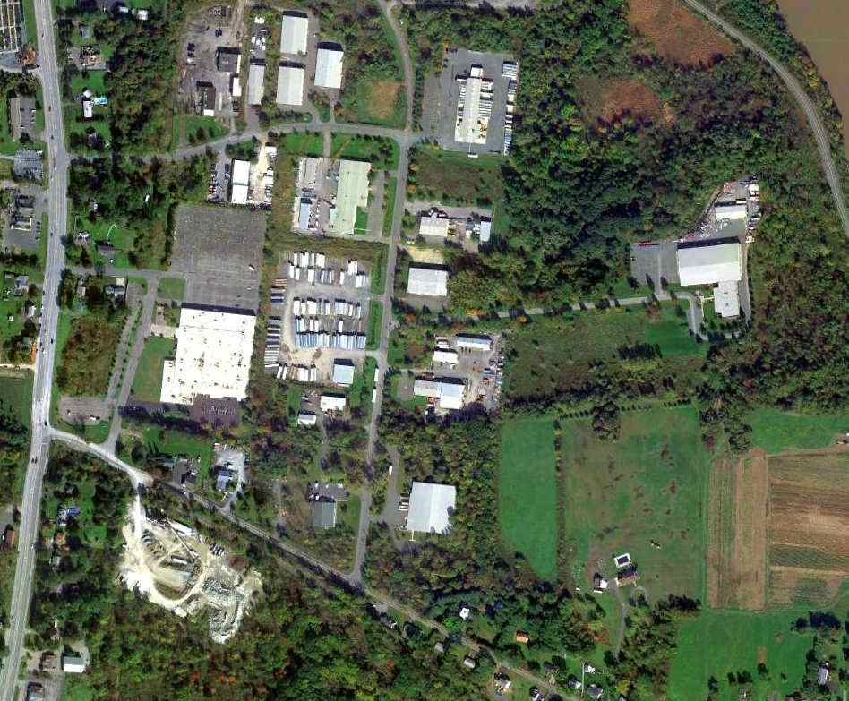
A 10/8/11 aerial photo shows that there does not appear to be any trace remaining of Loudon Airport.
The site of Loudon Airport is located northeast of the intersection of Fonda Road & Loudon Road, appropriately enough.
____________________________________________________
East Greenbush Airport, East Greenbush, NY
42.588, -73.712 (Southeast of Albany, NY)
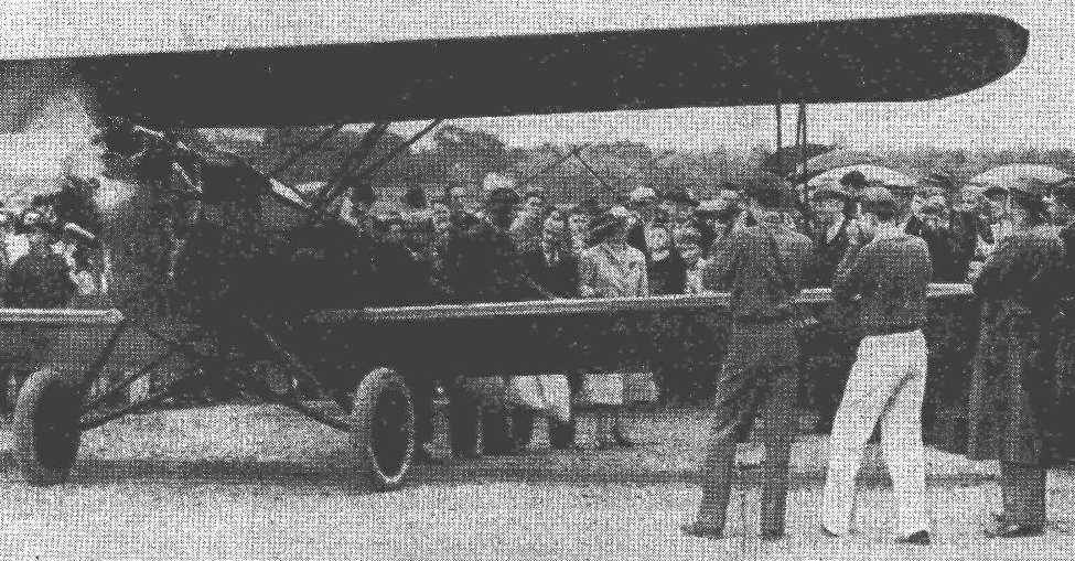
A 5/19/38 photo of George Canady in an unidentified biplane performing what he claimed to be the shortest flight in airmail history, across the river to Albany Airport,
commemorating the 20th anniversary of airmail service (courtesy of Paul Fulenwider).
The East Greenbush Airport was built by pilot George Canady & his brother in 1937, according to an article (courtesy of Paul Fulenwider).
The East Greenbush Airport was not yet depicted on the January 1940 Albany Sectional Chart.
The earliest aeronautical chart depiction which has been located of East Greenbush Airport was on the September 1940 Albany Sectional Chart.
A July 1942 photo of Robert Smith & William Drisenstock wheeling out the remains of a Cub after a fire at East Greenbush Airport,
which caused $35,000 in damage (courtesy of Paul Fulenwider).
An 8/18/42 aerial view looking north from the 1945 AAF Airfield Directory (courtesy of Scott Murdock)
depicted East Greenbush Airport as having a single unpaved north/south runway on the south side of Hays Road.
The clearing north of Hays Road was not delineated as being part of the airport.
The 1945 AAF Airfield Directory (courtesy of Scott Murdock) described East Greenbush Airport
as a 138 acre rectangular property having a single sand & sod 4,000' north/south runway.
The field was said to have 2 wood & metal hangars (the largest measuring 100' x 80'),
and was said to be owned & operated by private interests.
A circa 1940s/1950s photo of an unidentified man in front of a BT-13 & the East Greenbush hangar (courtesy of Paul Fulenwider).
A circa 1940s/1950s photo of 2 taildraggers outside the East Greenbush hangar (courtesy of Paul Fulenwider).
Note the Cub stored on its nose barely visible inside the hangar.
A circa 1940s/1950s photo looking northeast at a PT-22 at East Greenbush Airport (courtesy of Paul Fulenwider).
A circa 1940s/1950s photo of 2 Army L-4s at East Greenbush Airport (courtesy of Paul Fulenwider).
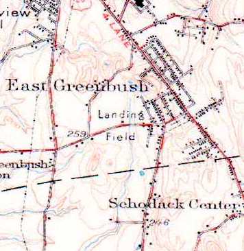
The East Greenbush Airport was labeled simply as "Landing Field" on the 1950 USGS topo map,
on both the north & south sides of Hays Road.
A 1950s photo of Bill Miller on a biplane at East Greenbush Airport.
Bill recalled, “Dad & Grandad flew out of this field. We owned a Cub Cruiser, Taylorcraft BC12 and a Piper Vagabond.
As a airport brat I got rides in the Stearman, Staggerwing and an RCAF Harvard. Great memories.”
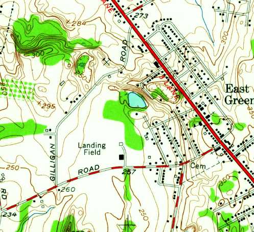
The 1953 USGS topo map only depicted the area on the north side of Hays Road as a "Landing Field".

A circa 1950s photo of several planes outside the East Greenbush hangar
(courtesy of Keith Campbell, who received the photo from the bus transportation supervisor whose office occupies the airport site).
Keith reported, “The flight school that's shown in the photo (Ferry Flying School)... Dick Ferry, who flew DC-3s during WW II, ran a flight school out of this hangar in the 1950s.
It was located where the present-day East Greenbush Central School Bus Barn facility is now.”
According to Paul Fulenwider, “East Greenbush Airport... Even though it was 'private' (no advertised services)
it was quite active in the 1950s when I was a kid & lived nearby.
The field consisted of a north/south turf 4,300' runway & a large hangar.
They had quite an array of aircraft then, including 2 Stearmans, 4 J-3 Cubs, 2 7-AC Champs,
a Waco UPF-7, a Fleet 16-B inch, a Fairchild PT-19, and for a time, a Jacobs 245 Beech Staggerwing.
There were at least 3 other partially disassembled aircraft & they had a large, attached rebuild shop.
They did a lot of flight instruction year-round & banner towing in the summer.
For several years, as a young kid in love with airplanes & aviation, I was part of the airport 'crew',
helping out wherever they would let me, during my summer school breaks, and boy, did I love it! I got paid in stick time!
The airport was a big part of my life between 1953-60.
The airport was reduced to the south side only after Canaday sold the north side to the County sometime around 1960.
The County... then built a school & school bus complex, and he retained the southern half
to which he added a hangar for himself & a couple of friends, for his Bonanza & their light plane, for flight instruction!”
The last aeronautical chart depiction which has been located of East Greenbush Airport was on the May 1957 Albany Sectional Chart.
It depicted East Greenbush Airport as having a 4,300' unpaved runway.
The East Greenbush Airport was no longer depicted on the May 1960 Albany Sectional Chart.
A circa 1960s aerial view showed the runway on the south side of Hays Road,
and showed that a school had been constructed on the northwest corner of the site (courtesy of Paul Fulenwider).
A 1978 USGS aerial photo showed the north/south runway on the south side of Hays Road,
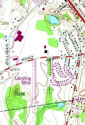
The 1980 USGS topo map only depicted an unpaved north/south "Landing Strip” on the south side of Hays Road.
Robert Cook reported, “When I got my license in 1984 I was in Schodsck Aviation & we had a Cessna 172 & 150 at East Greenbush Airport.”
The last photo which has been located showing East Greenbush Airport remaining intact was a 1986 aerial view.
The runway remained intact, along with a building on the northeast side.
Robert Cook reported, “East Greenbush closed in the late 1980s. Jimmy Fiel was a good friend & he flew the Piper Twin out in the late 1980s.”
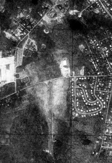
A 1995 aerial view showed that houses had been built over the north side of East Greenbush Airport.
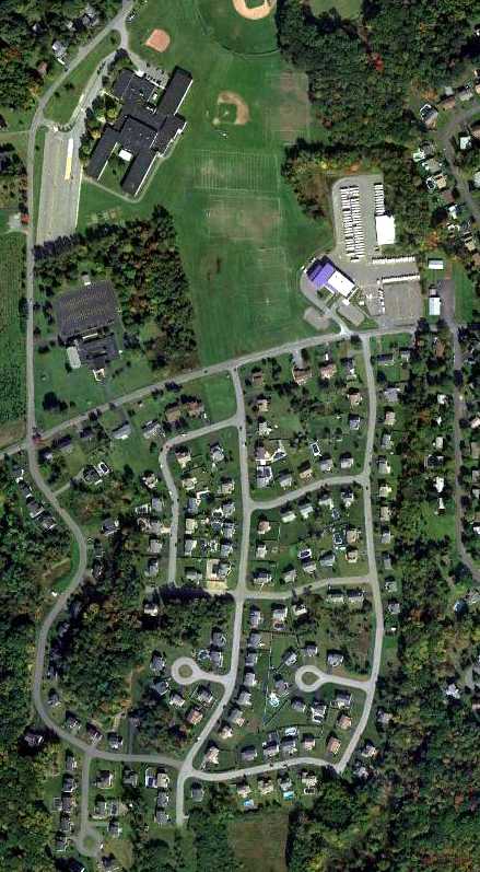
A 10/8/11 aerial photo shows that there does not appear to be any trace remaining of the East Greenbush Airport.
The site of the East Greenbush Airport is located northeast of the intersection of Hays Road & Gilligan Road.
____________________________________________________
42.703, -73.677 (Southeast of Albany, NY)

Troy Airport as depicted on the November 1931 NYC-Albany Air Navigation Map.
The original Troy Airport was located on the south edge of the town.
The date of construction of the Troy Airport has not been determined.
The earliest depiction which has been located of the Troy Airport was on the November 1931 NYC-Albany Air Navigation Map.
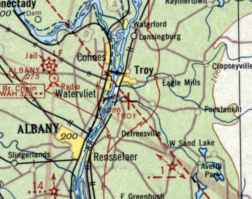
The June 1933 Albany Sectional Chart depicted Troy as an auxiliary airfield
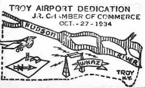
A postmark commemorated the 10/27/34 Troy Airport Dedication (courtesy of Mark Hess).
It's somewhat inexplicable that the airport was “dedicated” 3 years after it had already been depicted on aeronautical charts.
Mike Bronk (who "hung around the airport from 1953-57")
recalled that "I remember seeing a marker on the [administration] building
indicating that it (I assume the entire airport) was a Works Progress Administration project with a 1930's date."
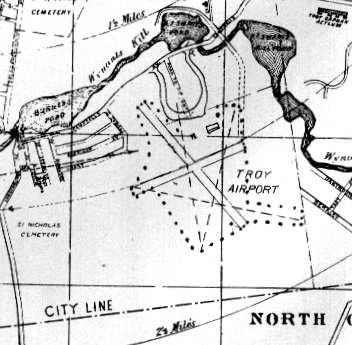
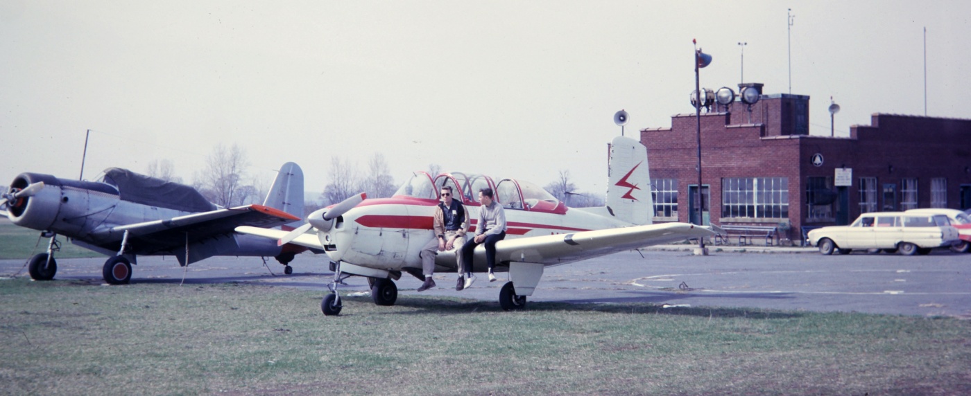
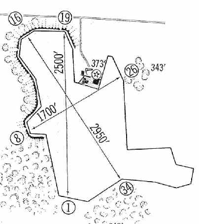
The airfield layout of Troy Municipal Airport, from The Airport Directory Company's 1937 Airports Directory (courtesy of Bob Rambo).
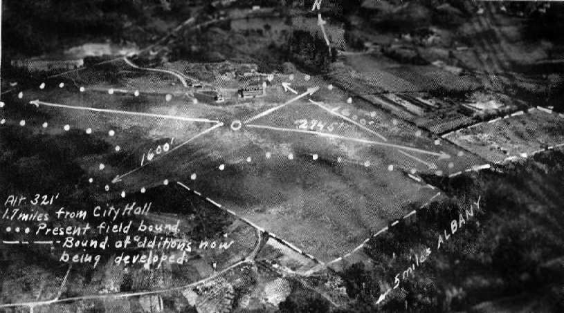
The earliest photo which has been located of Troy Municipal Airport was an undated aerial view looking north
from The Airport Directory Company's 1937 Airports Directory (courtesy of Bob Rambo).
The directory described the Troy Airport as having 2 grass runways, with the longest runway being a 2,745' northwest/southeast strip.
However, it pointed out that the field was being expanded, with a 3,100' landing/takeoff area to be available.
A single brick, steel, and concrete hangar was pictured at the north side of the airfield. The manager was listed as Robert Aldrich.
Jack Young recalled, "I was told that pilot training was conducted there in WW2.
I always assumed that was CPT training [Civilian Pilot Training], and not military training."
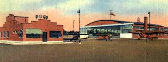
A 1942 postcard (courtesy of Mark Hess) depicted Troy Airport as having an office building & a hangar.
According to Mark Hess, “During the Summer of 1942, a Civil Air Patrol Squadron was started at Troy Airport, called the Troy Squadron.”
A 10/2/42 aerial view looking north from the 1945 AAF Airfield Directory (courtesy of Scott Murdock)
depicted Troy Airport as an irregularly-shaped grass area with a hangar on the north side.
The 1944 US Army/Navy Directory of Airfields (courtesy of Ken Mercer) indicated that Navy flight operations were conducted from the Troy Airport.
It described the field as having a 3,000' unpaved runway.
Gail Holcomb Willsey recalled, “My father, George Holcomb, took flying instruction at Troy Airport in 1944-45.
His first logbook entry was dated 9/17/44 & the aircraft was Luscombe 37098.
My dad had taken off from Troy Airport & logged 30 minutes of 'straight & level medium turns.'
His certified instructor was Edward French C-38513. There are several other entries all dating back from 9/22/44-4/29/45, all logged from Troy Airport.”
According to Keith Slupski, "Any use of this airfield for military flight training
was most likely associated with the Navy V-12 program
(accelerated college level technical schooling for military personnel - primarily officer candidates)
at Rensselaer Polytechnic Institute (RPI) during WW2.
The November 1945 Albany Sectional Chart (courtesy of Jim Stanton) depicted Troy as a commercial/municipal airport.
The 1945 AAF Airfield Directory (courtesy of Scott Murdock) described Troy Airport
as a 135 acre irregularly-shaped property having 4 sod runways, with the longest being the 2,950' NNW/SSE strip.
The field was said to have a 120' x 87' brick & steel hangar,
to be owned by the City of Troy, and operated by private interests.
A 1940s aerial view looking southeast at Troy Airport,
showing a hangar marked “Troy” with 4 single-engine aircraft parked on the ramp.
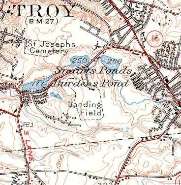
Troy Airport was labeled simply as "Landing Field" on the 1950 USGS topo map.
No runways were depicted, just the airfield boundary.
The May 1951 Albany Sectional Chart (courtesy of Paul Fulenwider) depicted Troy Airport as having a 3,000' unpaved runway.
Mike Bronk (who "hung around the airport from 1953-57")
recalled that "The administration building had a Link Trainer [an early flight simulator] installed,
which later went to the local CAP Squadron,
which was located in a building just outside the airfield gate, about 200 feet away from the administration building.
There were provisions for runway lights, but they were inoperable by the 1950s.
The CAP's building was a former military structure, lending credence to the military's use of the facility during WW2."
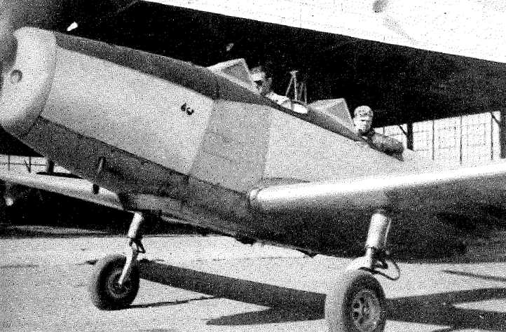
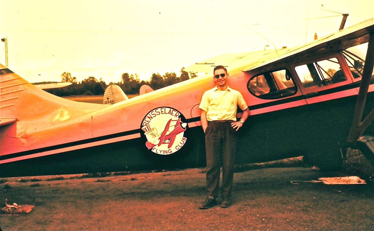
An undated photo from the 1952 RPI (courtesy of Austin Rivera)
of Dick Colgan & Warren Trott on Dick's checkout in a PT-19 in front of a Troy Airport hangar.
According to Austin Rivera, in the 1950s the Rensselaer Polytechnic Institute Aeronautical Federation
kept a Stinson Station Wagon & one other aircraft at Troy Airport.
Austin reported, "The airport was just on the south edge of Troy, not far from the RPI [Rensselaer Polytechnic Institute] campus.
The RPI flying club was based there & very active while I was there.
They had at least one Stinson Station Wagon,
and I remember a Cessna 195 & several other airplanes were also based there.
The airport was a large grass field with a northwest/southeast runway delineated by embedded white painted tires.
There may also have been a crosswind landing area but it was not marked as a runway, as I remember."
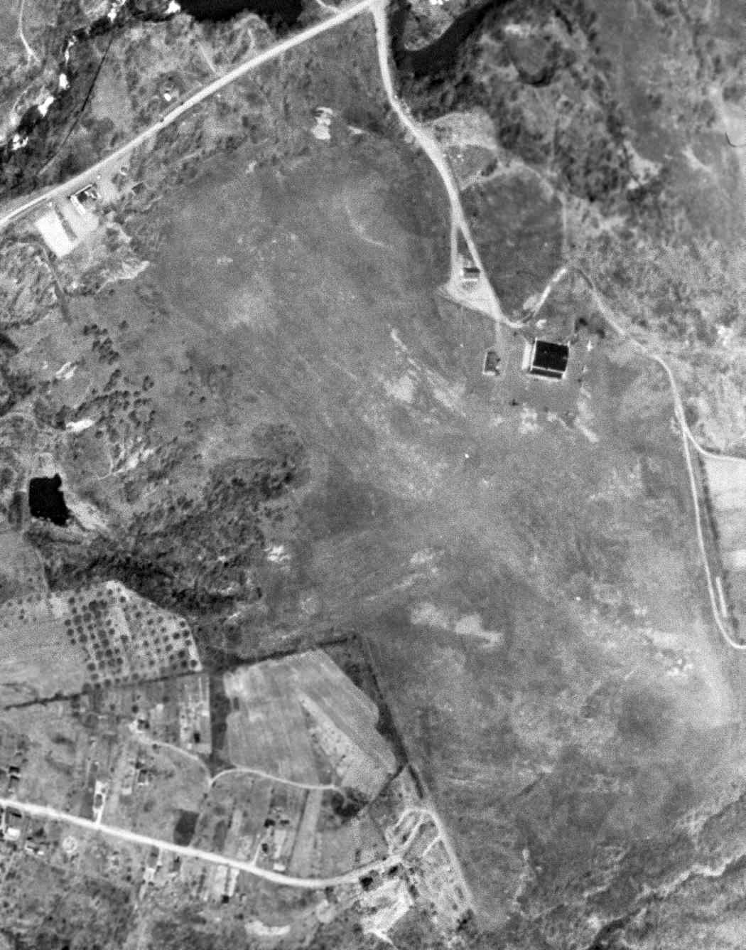
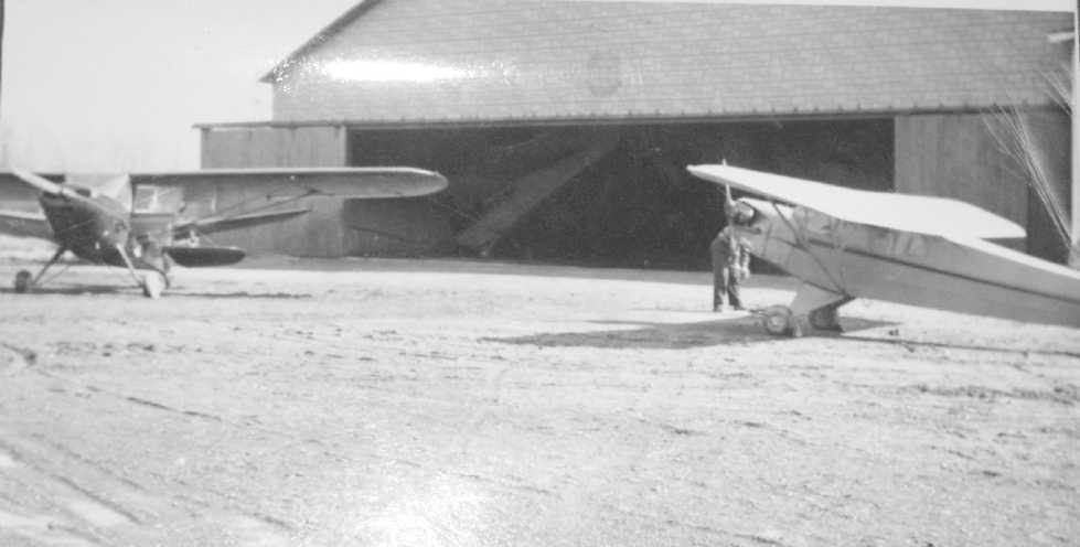
A 4/16/52 USGS aerial view of Troy Airport showed at least 3 single-engine aircraft parked near the hangar on the northeast side.
A circa 1957 photo by Ken Magill of an RPI Stinson, with the Troy Airport administration building in the background.
Ken recalled, “I started hanging around the Troy Airport in early 1957. My log book first entry was 6/22/57. My first ride was in the RPI Stinson.
I was 13 years old - I spent the next 5 years of my life there living & breathing airplanes, it was in my blood.
I was the airport gas boy that worked mowing the airport grass with an old jeep pulling a mower for flight time in the airport Cubs, Aeroncas and Stinsons.
A 1958 photo of Peter Morton & the RPI Flying Club Stinson at Troy Airport.
Peter recalled, “I was president of the RPI Flying Club in my senior year 1958. We had a Luscombe which would be on skis in the winter, and a Stinson that had been fully metalized [above].
We participated in the Association of Northeastern College Flying Clubs air meets, did spot landings and toilet paper cutting.
In the latter you unroll the first few feet of a roll of toilet paper & throw it out the window. Folks on the ground time how long it takes to cut it 3 times with your airplane; shortest time is winner.
The maneuver starts at 3,000' AGL. It resulted in neighbor complaints that we were TPing the town!
I had lovely adventures with both airplanes!”
A circa 1959-60 photo by Ken Magill (in the gray sweater) of the Beech T-34 he had flown to Troy Airport from the Hanscom Field Air Force Aero Club,
with the Troy Airport administration building in the background.
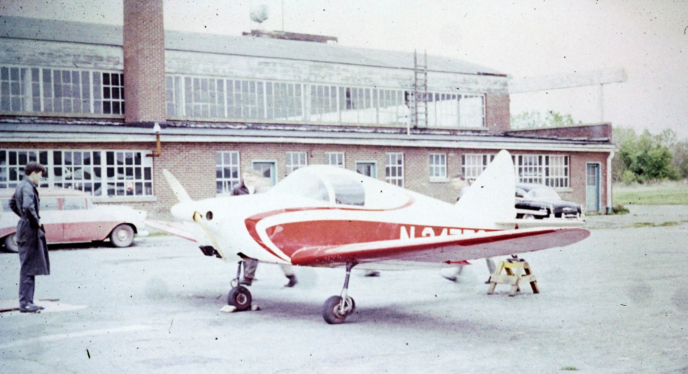
A circa 1959-60 photo by Ken Magill of a Culver Cadet on the side of the Troy Airport hangar closest to the in-ground gas pump.
The 1960 Jeppesen Airway Manual (courtesy of Chris Kennedy) depicted the Troy Airport as consisting of an irregularly-shaped grass area,
with the longest dimension being 2,950' northwest/southeast.
A few small buildings & a beacon were depicted on the north side of the field.
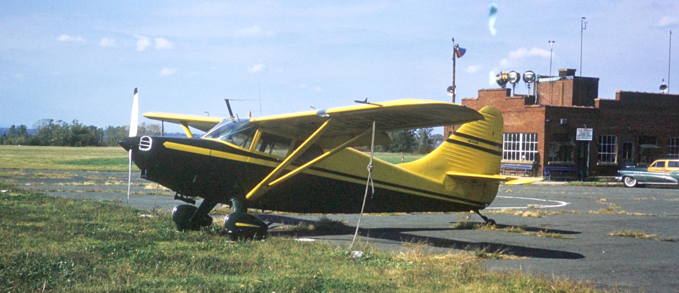
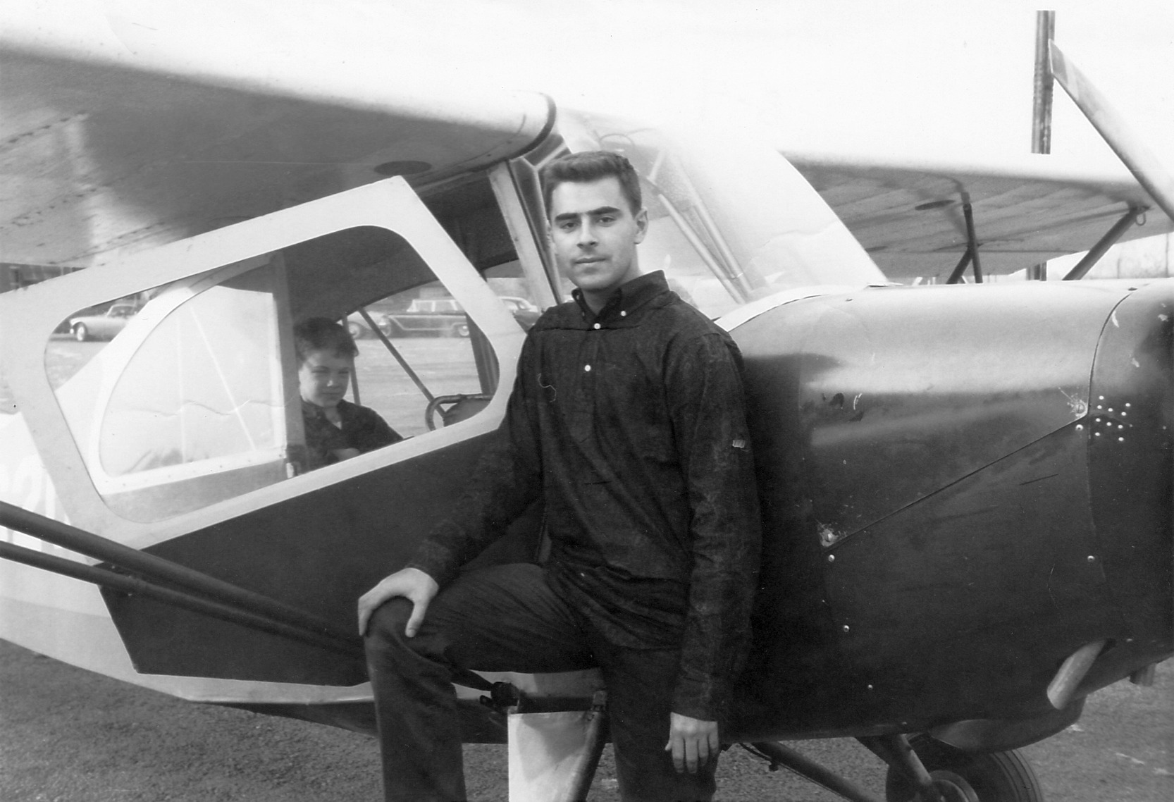
Two 1960 photos by Jack Young of his first airplane, a 1946 Stinson 108 Voyager, N97354, taken in front of the hangar of the Troy Airport.
Jack took these photos of his Stinson "when I was flying it out of the Troy Airport in the summer of 1960.
I acquired it there in the spring that year & operated there until I left the area in early 1961.
The hangar shown was one of 2 buildings on the airport,
the other being a red brick administration building, visible in the photo through the hangar door."
An undated photo from the 1961 RPI Yearbook (courtesy of Austin Rivera)
of members of the RPI flying club in front of their Stinson 108-3 & a Troy Airport hangar.
According to club member Henry Gurshman, “The 2nd person from the left in the rear line is Russ Haas, RPI Class of 1963.
Also in the rear line are Ray Cavicchio (5th or 6th from the left) & Sam Smith (7th from left).
George Johnson recalled, “Troy... I had taken an hour of dual [instruction] in a J-3 Cub from Bill McGrath on 4/23/62
when I was working on my Flight Instructor certificate.
The N number of the Cub was 98173 and his pilot # was 64644. It was a neat old airport then.”
The 1962 AOPA Airport Directory described Troy Airport as having 2 sod runways:
3,000' Runway 13/31 & 2,500' Runway 18/36.
The operator was listed as "Airport Operator of Troy, New York, Inc." - how creative!
Henry Gurshman recalled, “I joined the Rennselaer Flying Club in 1962 at the beginning of my sophomore year at RPI.
At that time Troy Airport was managed by Bill McGrath, with his sister assisting behind the counter.
At least one of them was a heavy smoker, and the office frequently had a cloud of smoke in it.
When I joined the flying club, it had 2 airplanes: a Stinson 108-3 Station Wagon & an Aeronca 7AC Champion.
Fred 'Sandy' Sandberg was our most frequent instructor.”
Henry continued, “When I flew there, only the longest runway (3,000' northwest/southeast) was used.
In the winter we put the Aeronca on skis; some effort was made to plow or flatten the snow on the runway,
but this meant that when the spring thaw came the runway was a sea of mud & unusable for several days until it dried out.
There were no lights, and remember illuminating the runway with my car's headlights one night in 1964
so that Russ Haas, who came back for a brief visit in his Luscombe 8E or 8F, could take off after sunset.”
Henry continued, “The field was also used for training a police motorcycle unit.
The motorcycles were left in the hangar, and some of us discovered that the ignition locks were so worn
that any key small enough to fit the ignition keyway could be used to turn the ignition on.
I learned to ride a motorcycle there, although not on a 'borrowed' police Harley-Davidson;
it was an Indian owned by a local attorney & pilot, Andy Dwyer.”
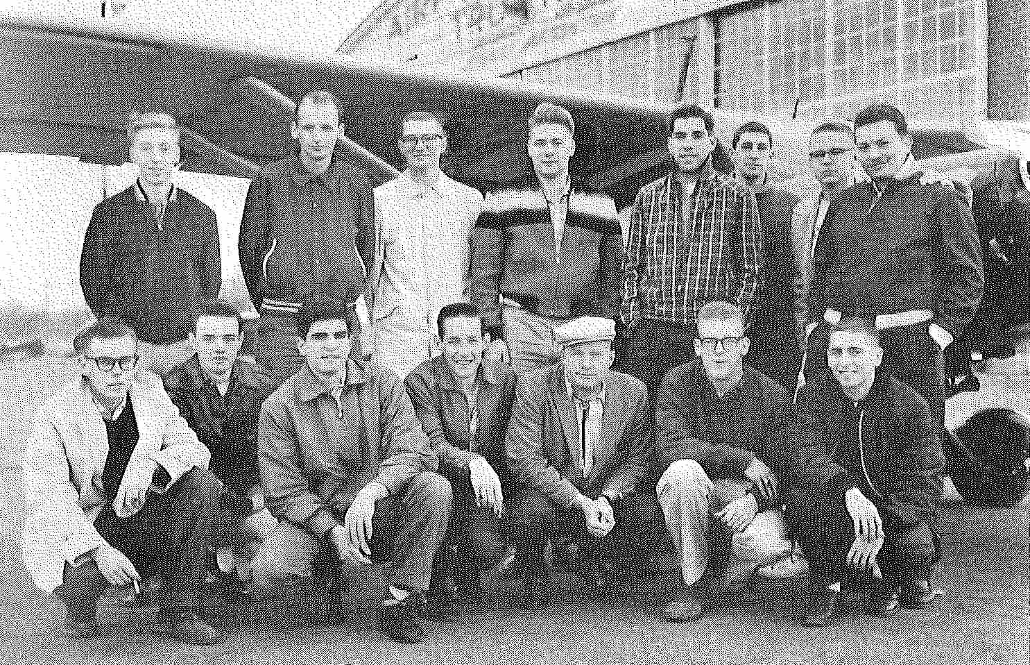
A 1963 photo of Norm Wainer (courtesy of Henry Gurshman) with an RPI Flying Club Aeronca at Troy Airport.

A 1963 photo of Dave Brown on Dave Willie's BT-13 at Troy Airport (courtesy of Henry Gurshman).
Henry Gurshman recalled, “”Dave Willie's BT-13... I got a ride in it one fall day when the heater was inoperative;
it was the noisiest aircraft I ever flew in (and of course I had no headphones, since there was no radio in it).”
Henry Gurshman recalled, “In 1963 or 1964, the club sold the Stinson & Aeronca & purchased a Piper Colt.”
Gail Holcomb Willsey recalled, “I remember my sister & I going on a plane ride at Troy Airport in the mid-1960s.
It was a fundraising event for a local charity & various pilots donated their planes, their time, and their flying expertise to offer rides to the general public for only a penny a pound.
I think it cost my dad less than 2 bucks for both my sister & myself to fly.
We were small enough for the both of us to buckle up in the 1 passenger seat right next to the pilot.
It was our first plane ride & it was very exciting & thrilling.”
The 1964 Albany Sectional Chart depicted Troy Airport as having a 2,900' unpaved runway.
According to Bob Bogash, RPI Flying Club President Norman Wainer took off from Troy Airport in the Flying Club's Piper Colt N5442Z on 5/31/64, “the last operational day for Troy Airport.”
By the time of the June 1965 Albany Sectional Chart, Troy Airport was no longer depicted.
According to Mike Bronk, "The initial use of the former airport was for the Hudson Valley Community College campus."
Jack Young recalled, "The land eventually became the site of a housing development."
By 1974, the USGS topo map showed that the original Troy Airport was gone by then,
after having been replaced by the Rensselaer Airpark, three miles to the east.
A 1994 USGS aerial photo showed the western portion of the Troy Airport property had been covered by a housing development,
while an industrial park had been built over the eastern portion.
Not a trace of the airport appeared to remain.
A 2015 aerial photo showed no trace remaining of Troy Airport.
The site of the Troy Airport is located south of the intersection of Campbell's Avenue & Industrial Park Road.
____________________________________________________
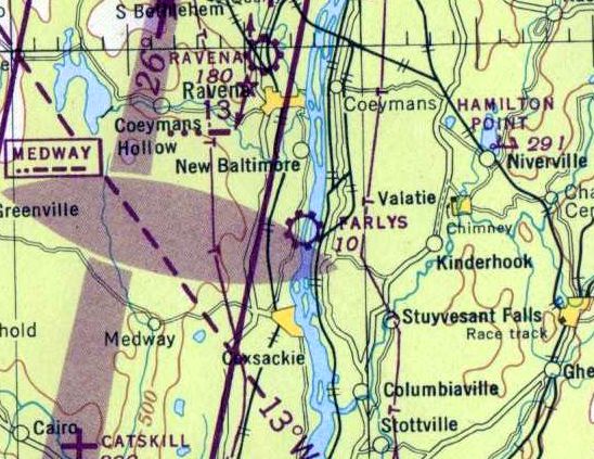
Farlys Airpark / Farley's Air Park / Farly Airpark, New Baltimore, NY
42.42, -73.788 (South of Albany, NY)
Farlys Airpark, as depicted on the November 1945 Albany Sectional Chart.
This small general aviation airport was evidently established immediately after WW2
(like many other small civilian airports in the postwar aviation boom),
as it was not listed among active airfields in the 1945 AAF Airfield Directory (courtesy of Scott Murdock)
nor depicted on the May 1945 Albany Sectional Chart.
The earliest depiction which has been located of Farlys Airpark was on the November 1945 Albany Sectional Chart,
which depicted Farlys as a commercial/municipal airport.
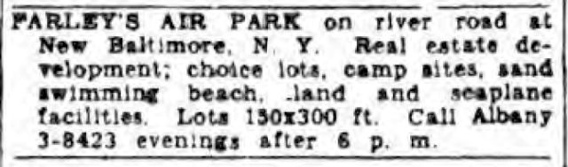
A 1/2/46 classified ad from Albany's Knickerbocker News (courtesy of Micheal McMurtrey) described lots for sale on the Farley's Air Park property,
which was also said to have seaplane facilities.
Farley's Airpark was listed as the owner of Cessna Bobcat NC60068 (MSN 2754), according to Michael McMurtrey.
John Granito recalled, “I learned to fly in 1951 at Farley's Airpark.
It was owned & run by John Bartell, who had returned as a pilot in the Spanish Civil War with enough money to purchase the facility -
dirt strip on the Hudson River, several hangars & a 'coffee shop'.
Land & sea - he was my instructor & also the flight examiner!
For $300 I got a Private Pilot's License & half interest in an old Porterfield on Edo floats - took a long time to get it off the water!”
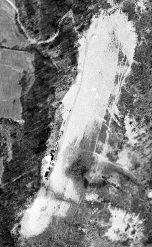
The only photo which has been located of Farley's Airpark was a 4/16/52 USGS aerial view,
which depicted 6 light aircraft & a few small hangars on the west side of a northeast/southwest unpaved runway.
The only topo map depiction which has been located of Farley's Airpark was on the 1953 USGS topo map,
which depicted a single northeast/southwest unpaved runway, labeled simply as “Landing Strip”, with 3 small buildings on the southwest side.
The last aeronautical chart depiction which has been located of Farly Airpark was on the July 1965 Albany Sectional Chart,
which depicted “Farly” as a private airfield with a 2,000' unpaved runway & an adjacent seaplane base.
Farley's Airpark continued to be depicted in an unchanged manner on the 1966 USGS topo map.
Farley's Airpark was evidently closed (for reasons unknown) at some point between 1965-68,
as it was no longer depicted on the July 1968 Albany Sectional Chart.
The 1981 USGS topo map only depicted an unlabeled clearing at the former location of Farley's Airpark.
A 1994 USGS aerial photo still depicted the clearing of Fairly Airpark,
but the buildings had been removed at some point between 1952-94.
A 10/17/11 aerial view showed no trace remaining of Farley's Airpark.
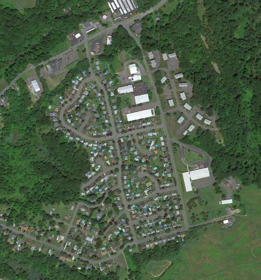
The site of Farley's Airpark is located southeast of the intersection of River Road & Kings Road.
Thanks to Micheal McMurtrey for pointing out this airfield.
____________________________________________________
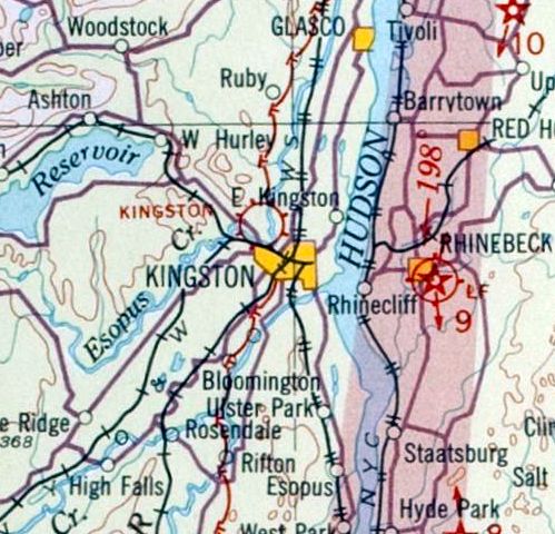
Kingston Airways Airport / Kingston Auxiliary Field / Kingston Airport, Kingston, NY
41.944, -74.027 (North of New York, NY)
Kingston Airport as depicted on the November 1931 NYC-Albany Air Navigation Map.
The date of establishment of this small airport has not been determined.
The earliest reference which has been located of this airport was on the 1929 Rand McNally Airport Directory (courtesy of Chris Kennedy).
It described the Kingston Airways Airport as a commercial airfield having a 1,800' x 1,200' landing area.
The earliest depiction which has been located of Kingston Airport was on the November 1931 NYC-Albany Air Navigation Map.
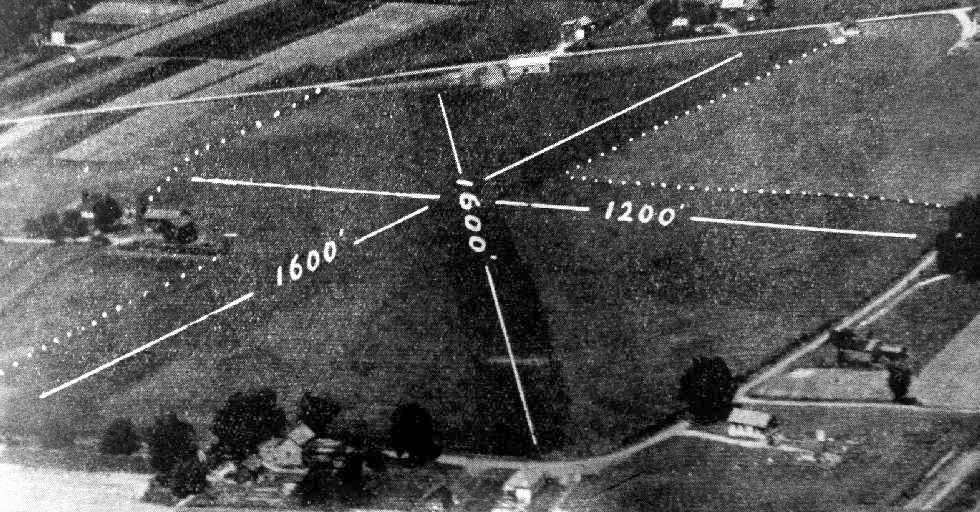
The earliest photo which has been located of Kingston Airport
was an undated aerial view from the Airport Directory Company's 1937 Airports Directory (courtesy of Bob Rambo).
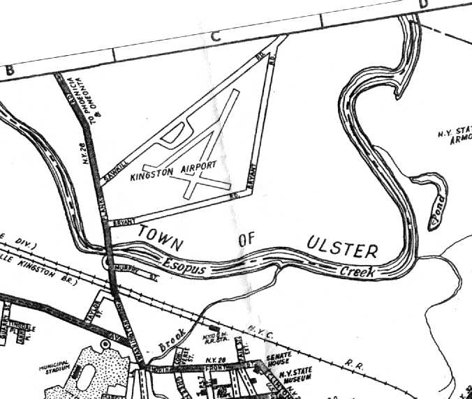
The directory described Kingston as a commercial airport consisting of an irregularly-shaped sod field with the longest dimension being 1,600'.
A hangar was said to be marked with the field's name.
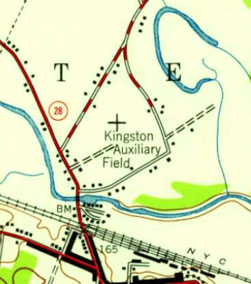
The 1942 USGS topo map depicted Kingston Auxiliary Field as an open area with several small buildings around its periphery.
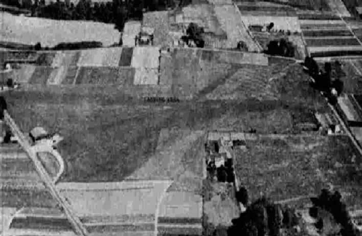
The only photo which has been located showing Kingston Airport while in operation was a 10/2/42 aerial view
from the 1945 AAF Airfield Directory (courtesy of Scott Murdock).
It depicted Kingston as having 3 grass runways & a single hangar.
The 1945 AAF Airfield Directory (courtesy of Scott Murdock) described Kingston Airport
as a 50 acre irregularly-shaped property having 3 sod runways, with the longest being a 1,900' northeast/southwest strip.
The field was said to have a single 60' x 60' steel hangar, and to be owned & operated by private interests.
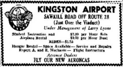
A 1946 advertisement for Kingston Airport (courtesy of Pierre Angiel)
described the operation as under the management of Larry Lyons,
and described the flying instruction, airplane rental, hangar space, repairs, and Aeronca sales offered.
A circa 1940s photo of Bill Scott at Kingston Airport (courtesy of Cheryl Nekos).
Cheryl Nekos recalled, “Kingston Airport... my dad [Bill Scott] ran a flight school there in the 1940s.”

A circa 1940s photo of a surplus Vultee BT-13 & an Aeronca at Kingston Airport (courtesy of Cheryl Nekos).

A circa 1940s photo of the Texaco windsock on top of the Kingston Airport hangar (courtesy of Cheryl Nekos).
The last aeronautical chart depiction which has been located of Kingston Airport was on the January 1949 Albany Sectional Chart.
It depicted Kingston as an auxiliary airfield.
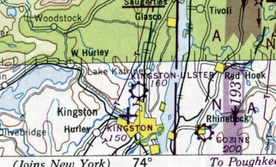
Note that it also depicted the nearby Kingston Ulster Airport to the northeast.
Kingston Airport was evidently closed at some point in 1949,
as it was no longer depicted on the July 1949 Albany Sectional Chart or subsequent aeronautical charts.
The 1950 USGS topo map continued to depict Kingston Auxiliary Field as an open area with several small buildings around its periphery.
A 1951 map (courtesy of Cheryl Nekos) depicted Kingston Airport as having 3 runways.
A 1963 aerial photo showed that Interstate 587 & Sawkill Road had been built through the center of the airport property.
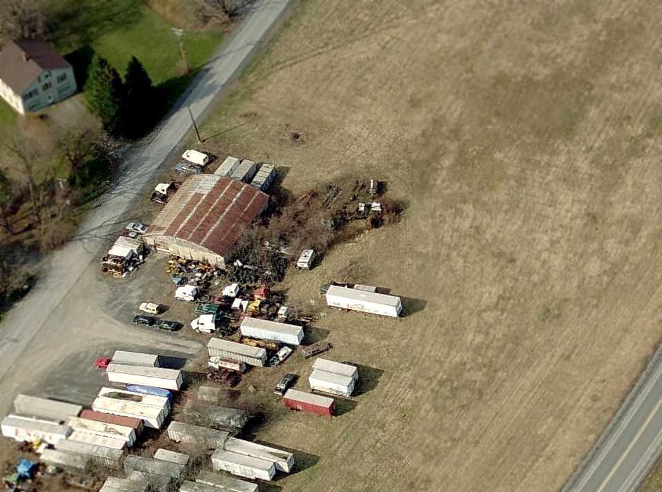
A circa 2011 aerial view looking north showing the Kingston hangar.
A 10/7/11 aerial view showed the former hangar in the center of the photo, but no other remaining recognizable trace of Kingston hangar.

A 3/17/13 photo by Randy Angiel (courtesy of Pierre Angiel) looking northeast at the former Kingston Airport hangar.
A 2023 photo looking northeast at the former Kingston Airport hangar.
The site of Kingston Airport is located north of the intersection of Interstate 587 & Sawkill Road.
Thanks to Pierre Angiel for pointing out this airfield.
____________________________________________________
Since this site was first put on the web in 1999, its popularity has grown tremendously.
If the total quantity of material on this site is to continue to grow,
it will require ever-increasing funding to pay its expenses.
Therefore, I request financial contributions from site visitors,
to help defray the increasing costs of the site
and ensure that it continues to be available & to grow.
What would you pay for a good aviation magazine, or a good aviation book?
Please consider a donation of an equivalent amount, at the least.
This site is not supported by commercial advertising –
it is purely supported by donations.
If you enjoy the site, and would like to make a financial contribution,
you
may use a credit card via
![]() :
:
Please consider checking the box to make a monthly donatation.
For a mailing address to send a check, please contact me at: paulandterryfreeman@gmail.com
If you enjoy this web site, please support it with a financial contribution.
please contact me at: paulandterryfreeman@gmail.com
If you enjoy this web site, please support it with a financial contribution.
____________________________________________________
This site covers airfields in all 50 states.