
Abandoned & Little-Known Airfields:
Northeastern Missouri
© 2002, © 2023 by Paul Freeman. Revised 10/6/23.
This site covers airfields in all 50 states: Click here for the site's main menu.
The MO pages of this website are sponsored by the Missouri Aviation Historical Society:
____________________________________________________
Please consider a financial contribution to support the continued growth & operation of this site.
Columbia Municipal Airport (revised 10/6/23) - E W Cotton Woods Memorial Airport (revised 10/6/23) - Haerr Field (revised 10/6/23)
Kratz Field / Suburban Airport (revised 10/6/23) - Lake Winnebago Municipal Airport (revised 10/4/23) - Marceline Municipal Airport (revised 10/6/23)
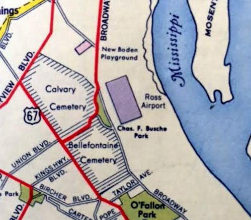
Ross Airport (revised 9/28/21) - St. Charles Municipal Airport (revised 10/6/23)
____________________________________________________
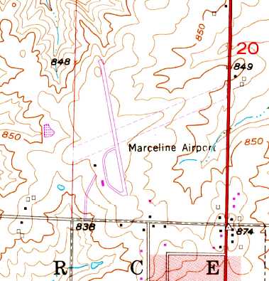
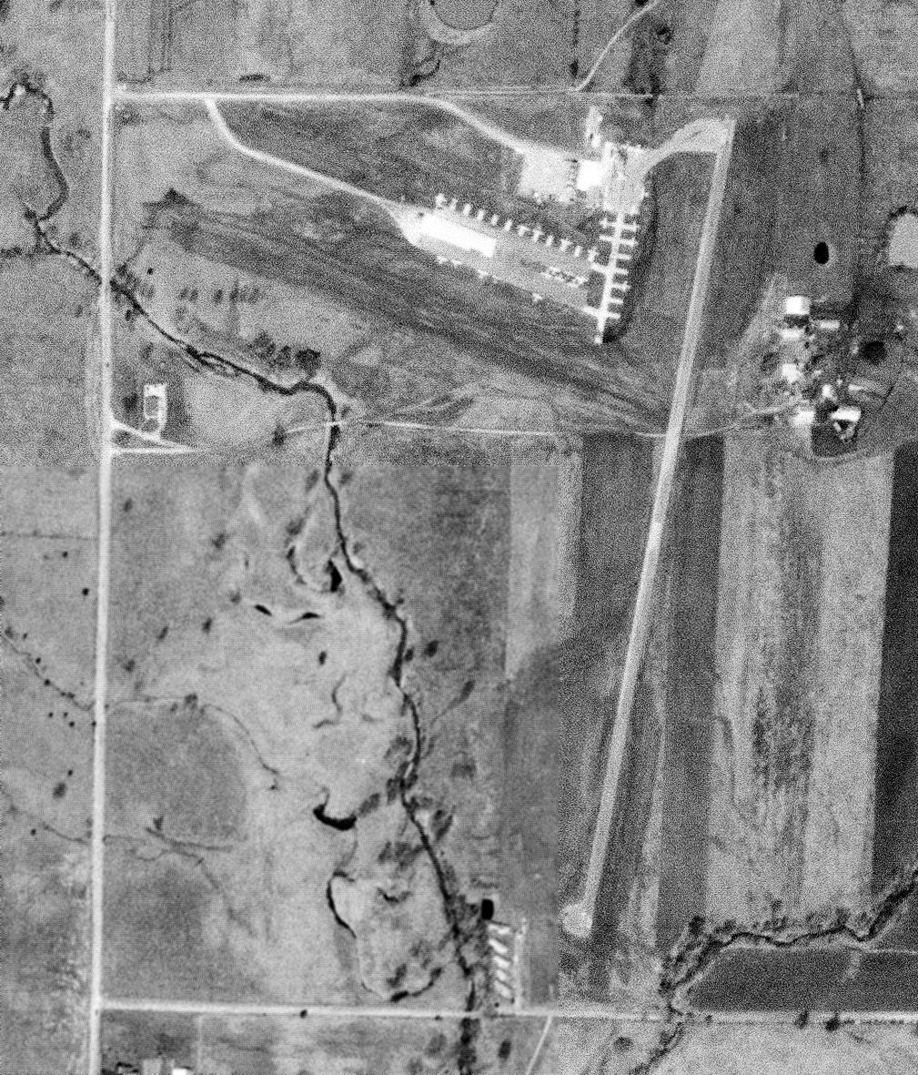
Marceline Municipal Airport, Marceline, MO
39.734, -92.949 (Northwest of St. Louis, MO)
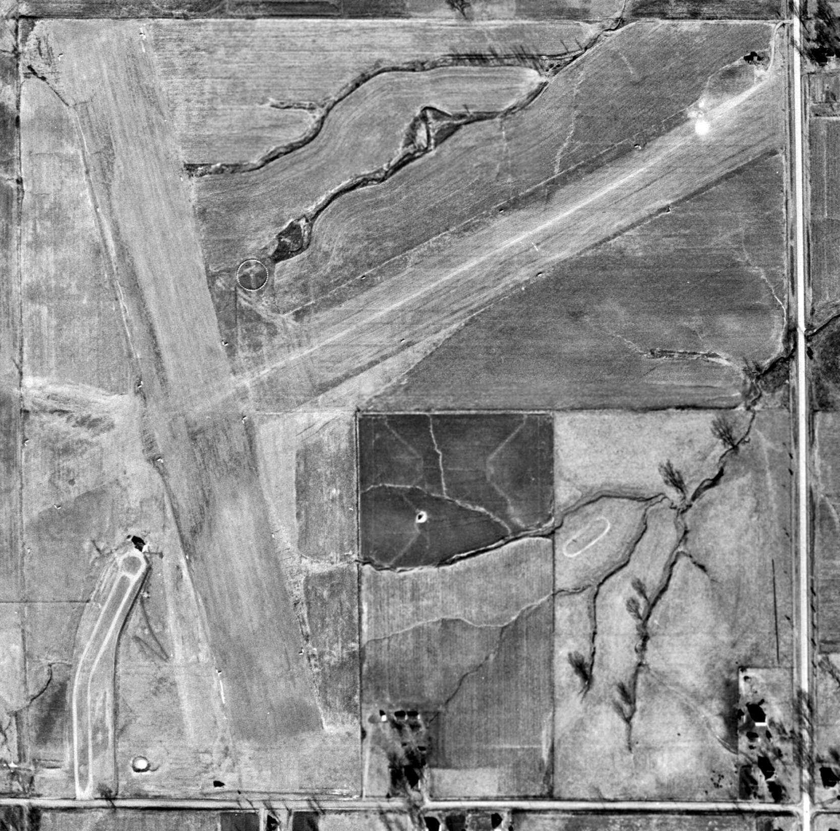
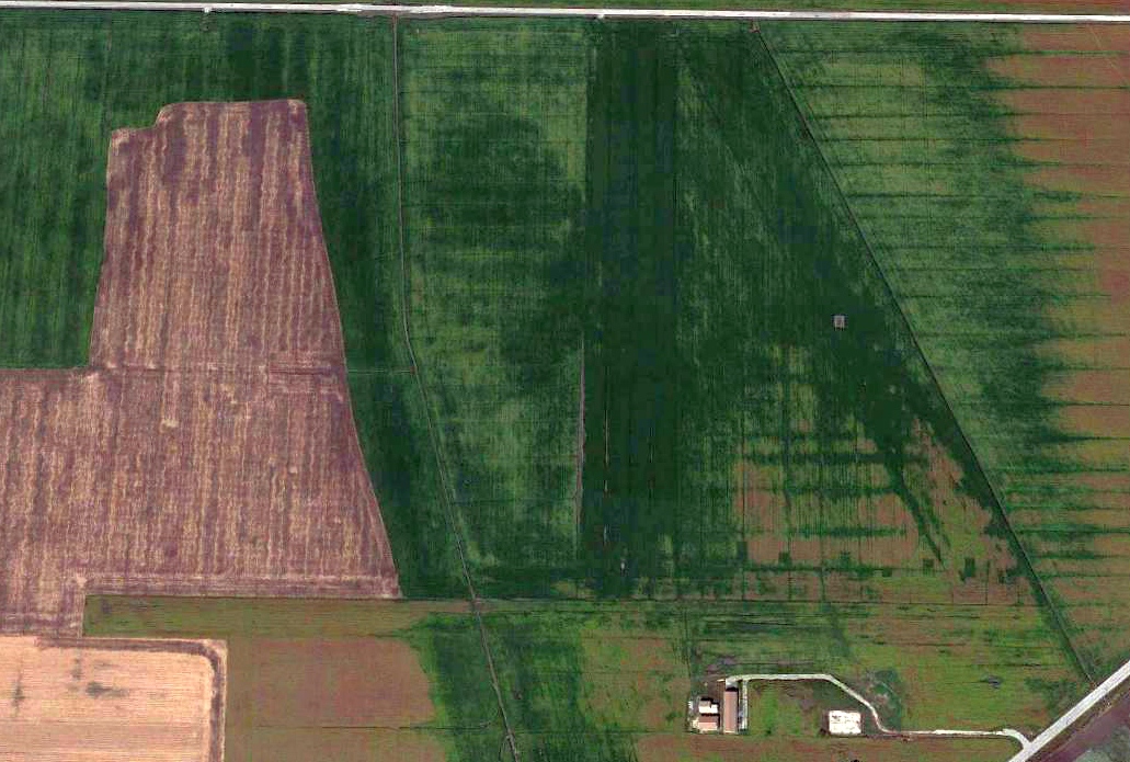
Marceline Airport, as depicted on a 12/24/59 USGS aerial photo.
This general aviation airport was evidently established at some point between 1945-49,
as it was not yet depicted on the March 1944 Kansas City Sectional Chart (courtesy of Ron Plante)
nor in the 1945 AAF Airfield Directory (courtesy of Scott Murdock).
The earliest depiction which has been located of Marceline Airport was a 12/24/49 USGS aerial photo.
It depicted the field as having 2 perpendicular unpaved runways, with a single small building southwest of the runway intersection.
There were no aircraft visible on the field.

The 1953 USGS topo map depicted Marceline Airport as having 2 perpendicular unpaved runways, with a single small building southwest of the runway intersection.
Marceline's northwest/southeast runway was evidently paved at some point between 1953-79,
as that is how the field was depicted on the 1979 USGS topo map.
It also had a paved taxiway leading to a 2nd building on the southwest side.
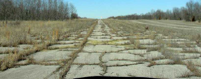
The last photo which has been located showing Marceline Airport while open was a 2/23/95 USGS aerial view looking northeast.
There were several hangars & T-hangar on the southwest side, but no aircraft were visible.
According to Ken Jay, the “reason for closure of this airport (and the nearby Brookfield Airport)
was a cooperative agreement between Brookfield & Marceline that provided for the construction & operation
of a regional airport with a much longer runway & greater utility.
The closure of the two airports was a requirement of that agreement & also the sale of the Brookfield airfield property was part of this agreement as well.”
The North Central MO Regional Airport in Brookfield opened in 2002,
which is presumably the point at which the Marceline Airport was closed.
According to Floyd Taber, “When I was last in Marceline [2006] the runway had been ground up & was being used as fill
and I got to see a Beech Bonanza do a low pass over what used to be the airport runway.”
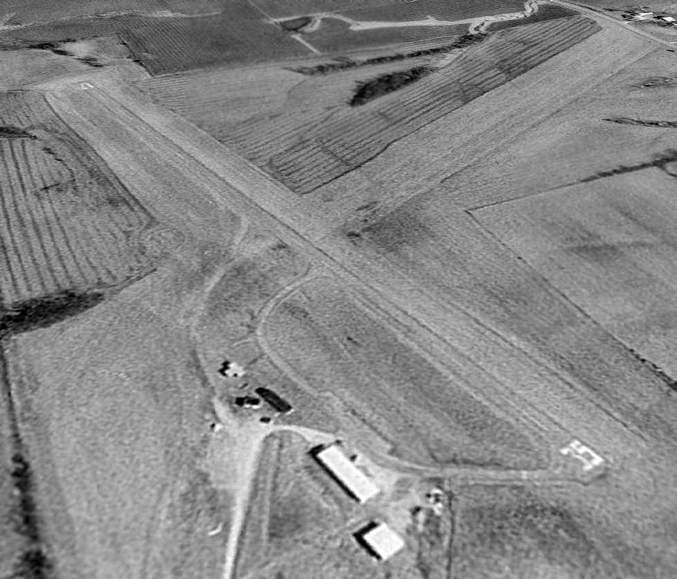
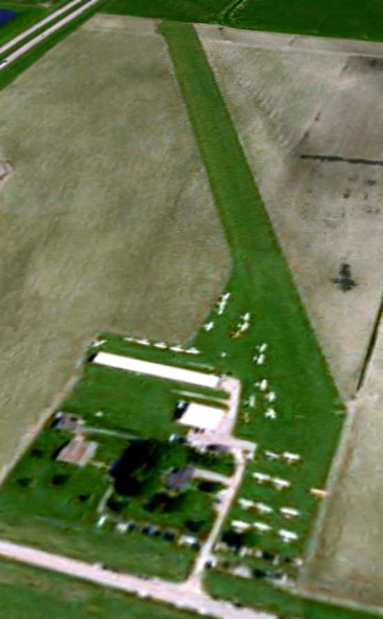
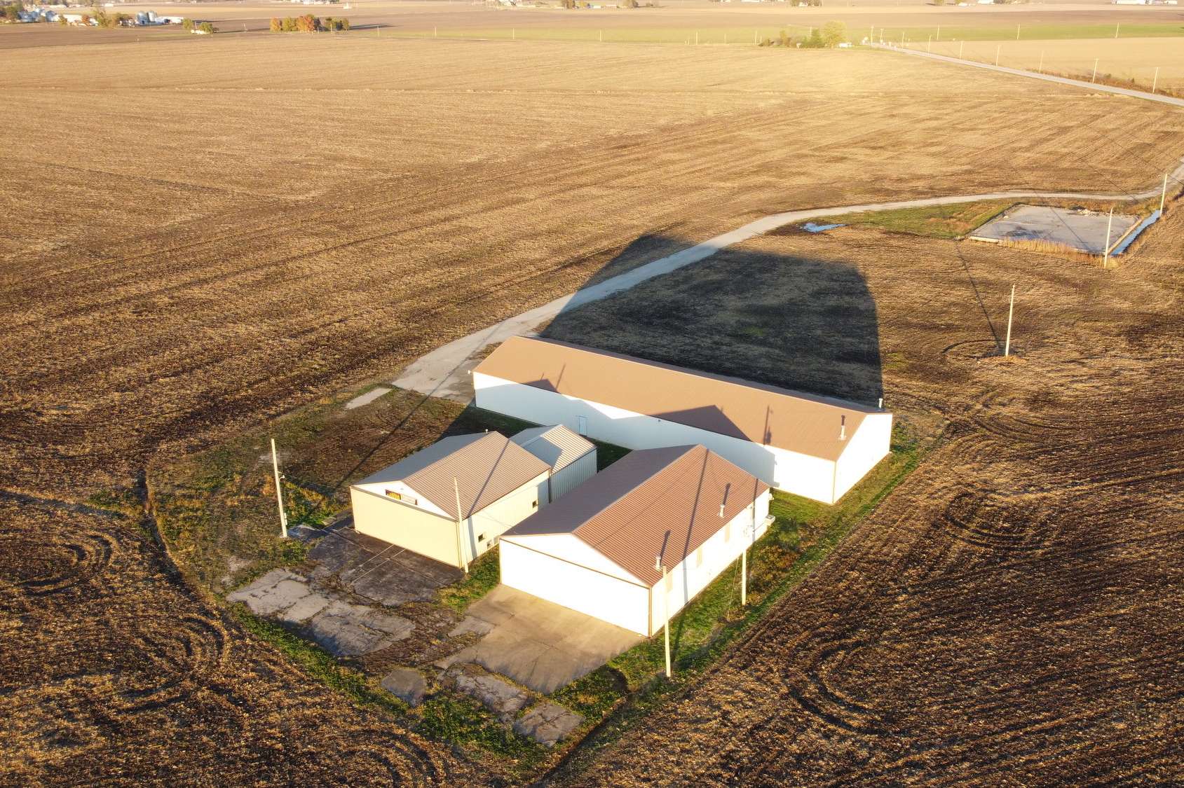
A 6/16/09 aerial view looking northeast showed that the majority of Marceline Airport remained intact,
with the exception of some pavement on the south end of Runway 35.
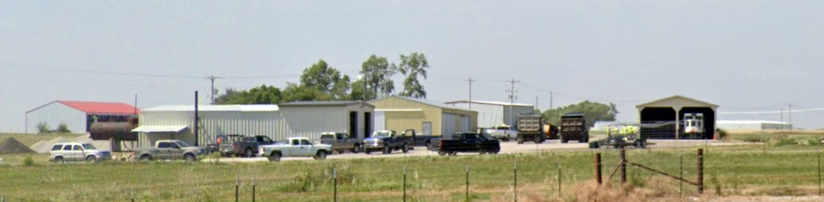
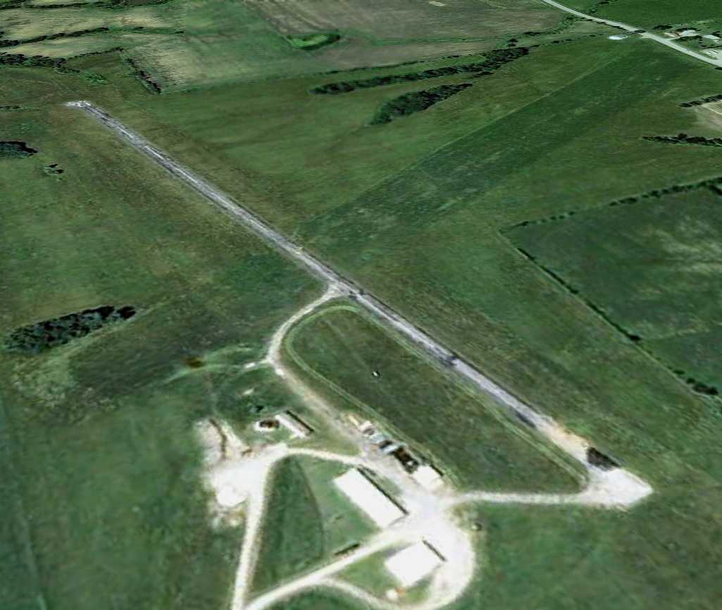
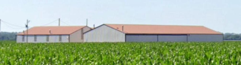
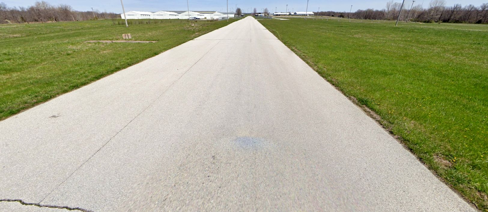
A 2023 photo looking north at the former Marceline Airport hangars.
The site of Marceline Airport is located northwest of the intersection of North Broadway Street & Route 5.
____________________________________________________
Haerr Field (MO14), Taylor, MO
39.94, -91.51 (Northwest of St. Louis, MO)
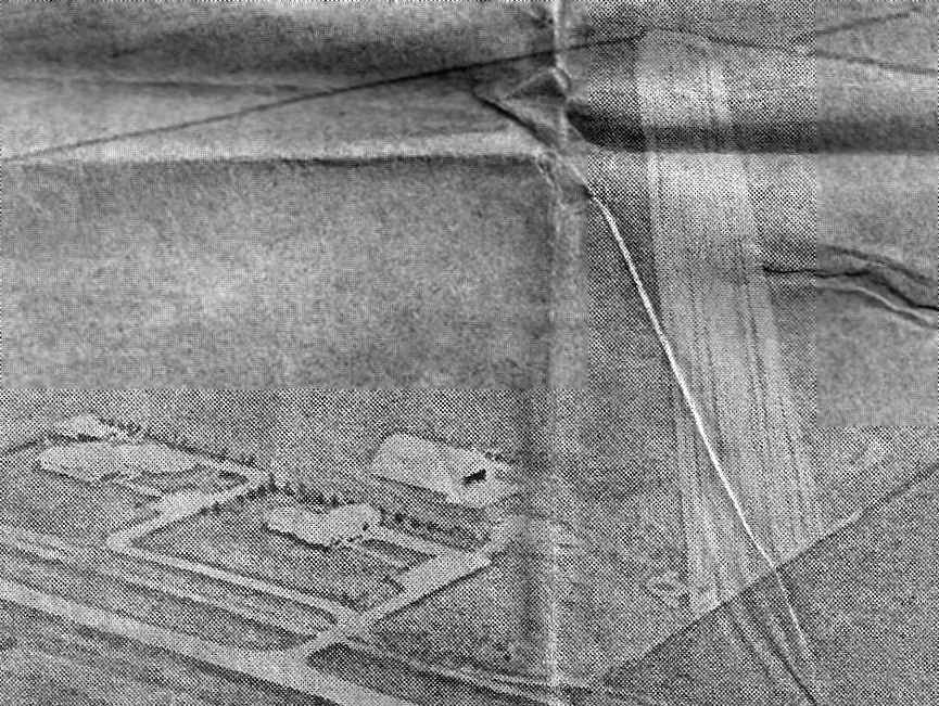
A circa 1960s aerial view looking northwest at Haerr Field (courtesy of Jon Ferguson).
According to Jon Ferguson, Haerr Field was built by Norman Haerr in 1966.
The earliest depiction which has been located of Haerr Field
was a circa 1960s aerial view looking northwest at Haerr Field (courtesy of Jon Ferguson).
A 3/21/69 USGS aerial view depicted Haerr Field as having a single unpaved northwest/southeast runway & a cluster of buildings at the southwest end.
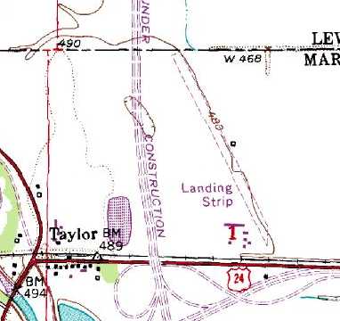
The earliest topo map depiction which has been located of Haerr Field was on the 1975 USGS topo map.
It depicted a single unpaved northwest/southeast runway, labeled simply as “Landing Strip”,
with a cluster of buildings at the southwest end.
Jon Ferguson recalled, “We moved to the airport at Taylor in 1983 & would stay until 1988.
I remember being very excited for this new adventure. My parents had taken on management of this small Fixed Base Operator.
I look back on this time as the very highlight of my childhood. Little did I know that our time at Taylor would be the airport's heyday.
Haerr Field (MO14) had a 2,865' grass Runway 15/33 with sidelong taxiway.
It still has the large Quonset-style hangar & a number of T-hangars.
The site had a small building with large windows that acted as our Operations building.”
Jon continued, “My parents went to great lengths to make the place profitable.
The place never made us any money when we ran it & my folks tried everything.
The best we could hope for is to break even.
We held a few air shows & a number of pancake breakfasts. We tried offering skydiving.
They gave flying lesson's there. In fact many of you may have learned to fly at our little airport.
It was here that I would be steeped in aviation & it would remain in my blood forever.
Unfortunately try as they might my folks just couldn't seem to make the place profitable.
I remember vividly them putting on air shows & these were great fun
but an alarming number of people would park just outside the airport grounds along the road & watch the show for free.
It would be my first lesson in business: even good people will not buy the cow if they can get the milk for free.”
Jon continued, “My parent's called our little slice of aviation Mecca 'Taylor Aviation'.
The place was paradise for a number of kind pilots who would come by daily.
Many of those guys were WWII, Korea, and the more recent Vietnam veterans.
My childhood favorite was a fellow named Harry (Windy) Windgerter.
A kind old man who always took the time teach an adolescent boy important things.
When my time on this Earth is done & I pass on to the next place Windy will be one of the first people I look up.
Incidentally nobody called him Harry because he was completely bald!”
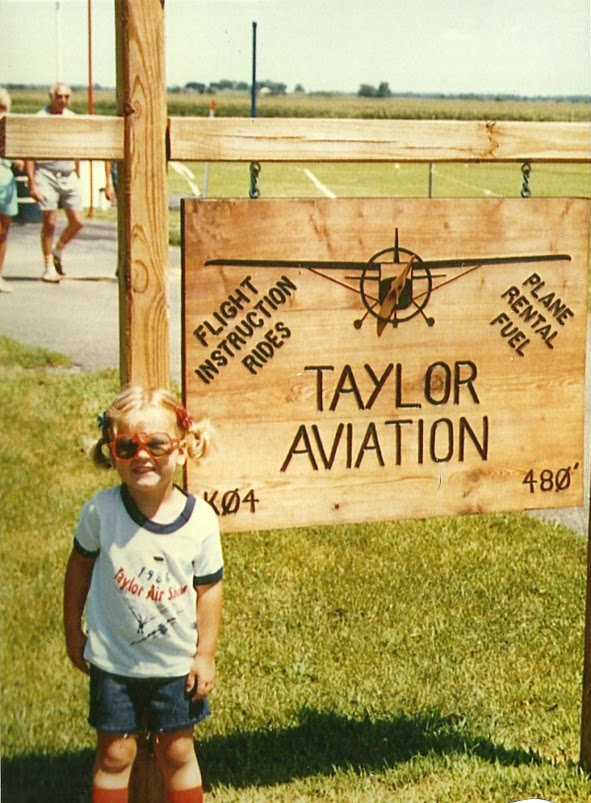
A 1986 photo by Jon Ferguson of the sign for Taylor Aviation.
Jon Ferguson recalled, “Another who made his stamp on our little airfield was Darwin McClure.
Darwin was head pilot for the Mormons Feed company & privately owned a Piper J-3 Cub.
During airshows Darwin could be counted upon to do his Maude act.
The old guy would dress up as an old lady that we called Maude.
The announcers would say that Maude had one free plane ride & my Dad would be the pilot.
Dad would wear a ball cap & put 'Maude' into the back seat & he would climb into the front seat.
He would rev the motor & his hat would 'blown' out of the window.
So he would jump out & leave Maude unattended in a running airplane & fetch his hat.
This is when Darwin dressed in drag as Maude would gun the engine & fly off leaving the crowd of spectators stunned.
The PA commentators would have a thrilling narrative about the perils of the flight & how we should all pray for Maude to return safely to Earth.
They would try to tell Maude how to fly & guide her back to the runway.
Whilst this was going on Darwin would give us a great air show, he would loop & roll & buzz the runway.
He had found a slight depression in a nearby cornfield & he found that he could dive out of view & then pop out right in front of everybody.
Of course Darwin would eventually land & come out of the plane & we would be told that Maude was actually stunt pilot Darwin McClure.”
Jon continued, “In our last years of ownership we rented out one of the T-hangars to a family friend named Roger Geers.
He moved his R/C hobby shop into the T-hangar & sold radio-controlled model planes & one could often see folks flying them just outside the T-hangar.
Though our airport couldn't seem to stay afloat the hobby shop did very well.
Roger would in the end manage the airport after we packed up & left [1988].
Most websites still have Roger listed as airport manager so he was still running the place well into the age of the Internet.”
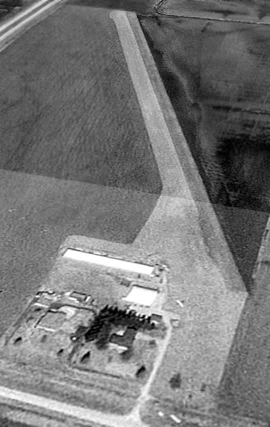
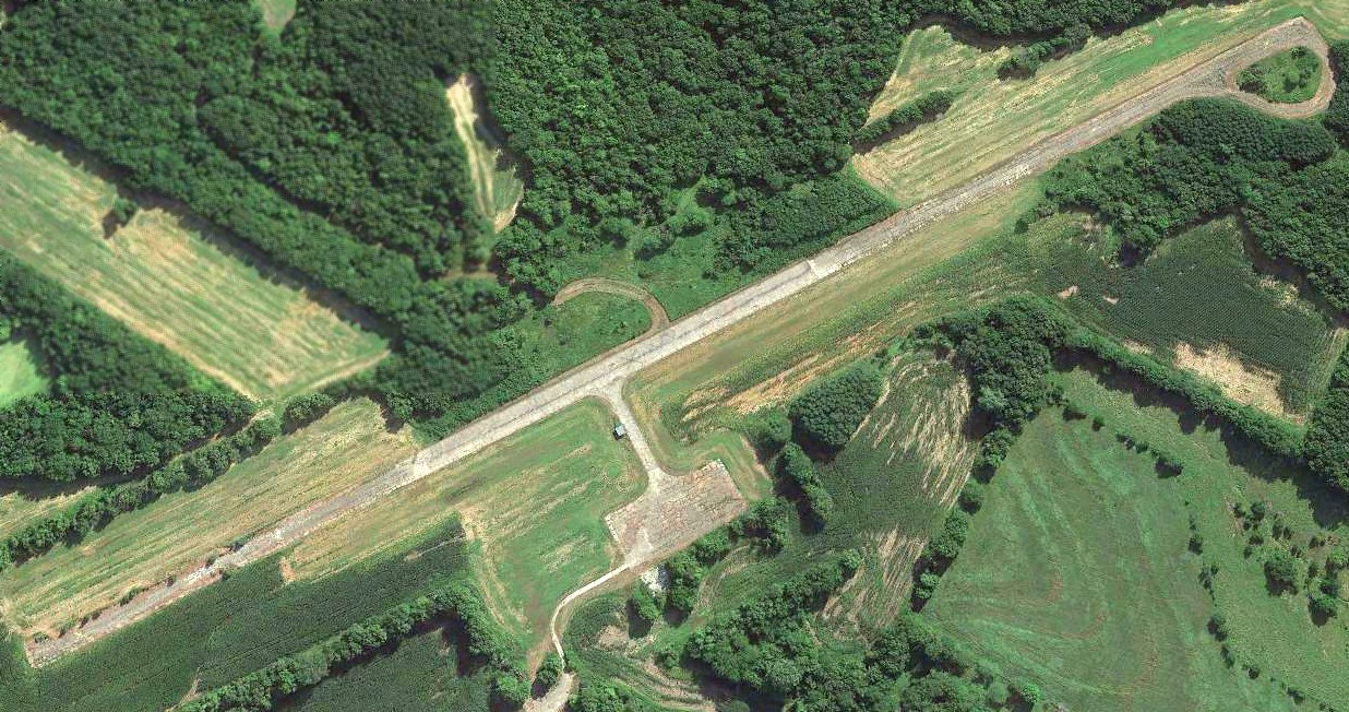
A 2/26/95 USGS aerial view looking northwest showed Haerr Field to have a single grass runway,
with a cluster of buildings at the southwest end, near which was visible a single aircraft.
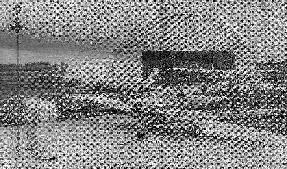
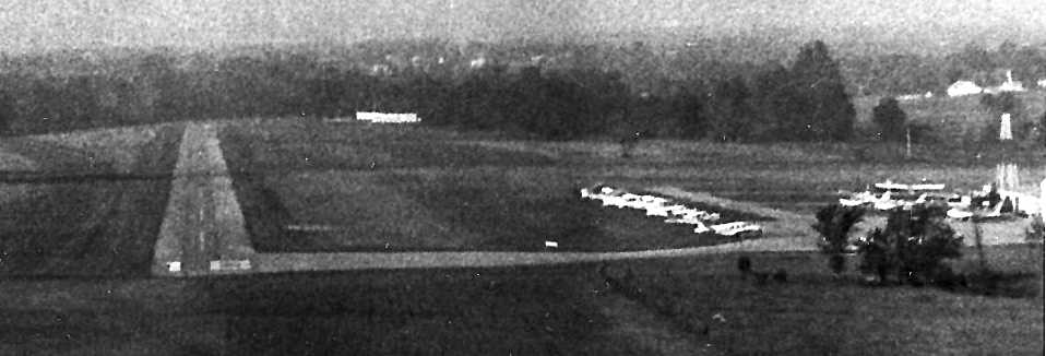
The heyday of Haerr Field was depicted by a 1/1/03 aerial view looking northwest, showing no less than 32 aircraft gathered at the field,
filling nearly every available parking spot, perhaps for some kind of fly-in?
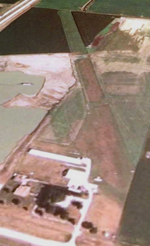
The last photo which has been located showing any aircraft at Haerr Field was a 6/15/05 aerial view looking northwest, showing a single aircraft.
Note that the property adjacent to the west side of the runway had started to be used at some point between 2003-2005
for some sort of surface mining or dredging.
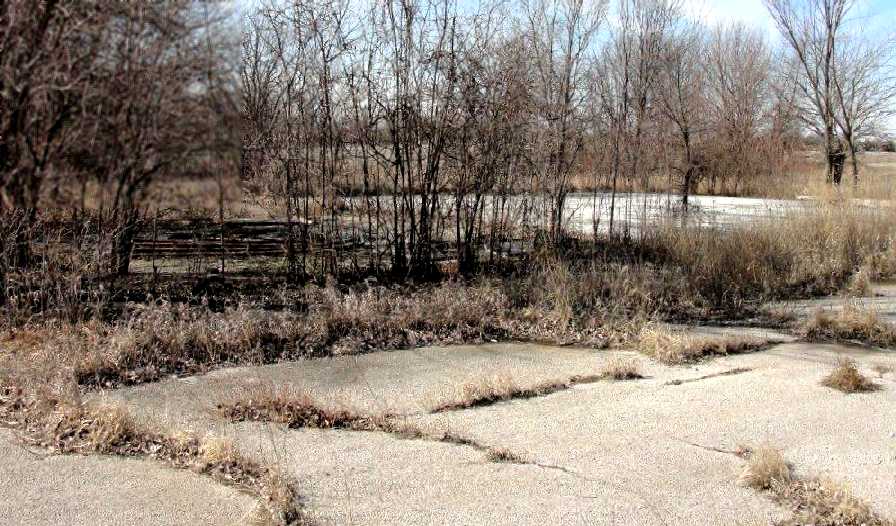
According to Jon Ferguson, “Norman Haerr... had to shut the airport down in 2009 because the insurance was just getting too expensive.”
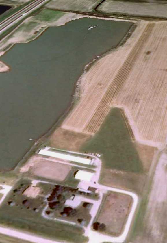
A 6/16/09 aerial view looking northwest showed that the dredging pond had expanded to take over the northern portion of the former Haerr Field runway,
but the hangars remained standing.
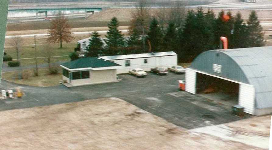
Jon Ferguson reported in 2012, “Nowadays the airport is pretty much gone.
The hangars remain but I am told that the place is a horseback riding school now.”
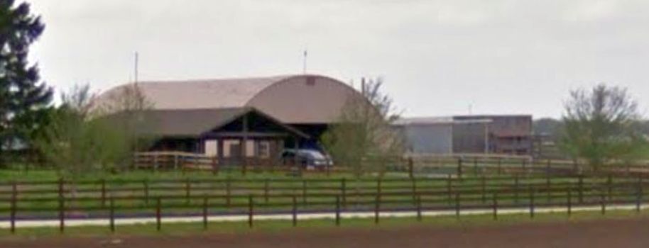
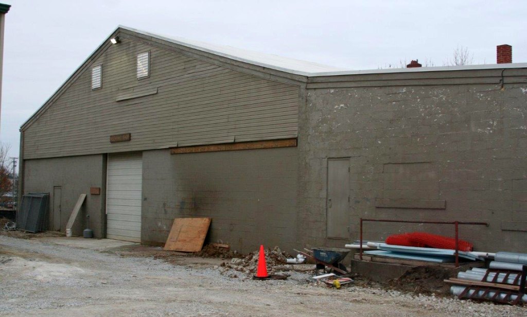
A 2018 photo looking northwest at the former Haerr Field hangars.
The site of Haerr Field is located northeast of the intersection of Route 61 & Route 24.
____________________________________________________
38.703, -90.224 (Northwest of Downtown St. Louis, MO)
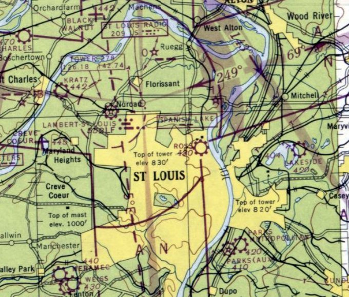
Ross Airport, as depicted on the September 1946 Kansas City Sectional Chart.
The date of establishment of Ross Airport has not been determined.
The adjacent St. Louis Car Company (a manufacturer of railway cars & streetcars) produced various aircraft under license & of its own design starting in 1915.
St. Louis Car eventually joined with Huttig Sash & Door Company to form the St. Louis Aircraft Corporation.
Ross Airport was not yet listed among active airfields in The Airport Directory Company's 1937 Airport Directory (courtesy of Bob Rambo)
nor depicted on the 1940 USGS topo map.
According to an article by Frederick Roos in the 2/98 Gateway News,
“St. Louis Aircraft developed & flew in 1940 the PT-LM-4, a sleek, low-wing, all-metal primary trainer with a Ranger in-line engine.
Although tested by NACA, the Army, and in Canada, the PT-LM-4 was not put into production.
Instead, the Army gave St. Louis Aircraft production contracts for the similar Fairchild-designed PT-19 trainer.”
St. Louis Aircraft also developed the XCG-5 troop-carrying glider starting in 1941, and flew it from Lambert Field in 1942.
It is not known if the XCG-5 ever operated from Ross Airport as well.
Ross Airport was not depicted on the 1942 / 1944 / 1945 / March 1946 Kansas City Sectional Charts.
According to an article by Frederick Roos in the 2/98 Gateway News,
“During 1942-44, St. Louis Aircraft built & delivered 350 of the PT-LM-4 primary trainers, in 2 versions:
the PT-19A, with a Ranger in-line engine, and PT-23/PT-23A, with a Continental radial.
These trainers were all test-flown at St. Louis Aircraft's own flying field, adjacent to the St. Louis Car factory on North Broadway in St. Louis
(this field was operated as a private airfield, Ross Airport, for a time after WW2).”
Ross Airport was not listed among active airfields in the 1945 AAF Airfield Directory (courtesy of Scott Murdock).
The earliest depiction which has been located of Ross Airport was on the September 1946 Kansas City Sectional Chart.
It depicted Ross as commercial/municipal airport.
The earliest photo which has been located of Ross Airport was an undated aerial view looking southeast from the 1947 MO Airport Directory (courtesy of Joe Gurney).
The directory described Ross as “municipally & privately owned”, managed by Walter Ross.
It was said to have 2 runways: 3,000' northwest/southeast oiled & 2,850' north/south turf.
A single hangar was pictured at the north end.
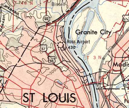
Ross Airport, as depicted on the 1947 USGS topo map.
The last aeronautical chart depiction which has been located of Ross Airport was on the May 1950 Kansas City Sectional Chart.
It depicted Ross as having a 2,300' paved runway.
Ross Airport was evidently closed (for reasons unknown) at some point in 1950,
as it was no longer depicted on the December 1950 Kansas City Sectional Chart.
A 1952 road map (courtesy of Kevin Walsh) depicted Ross Airport as a rectangular property outline.

The 1954 USGS topo map depicted Ross Airport as having 2 runways in an X-shape, with one small building on the northwest side.
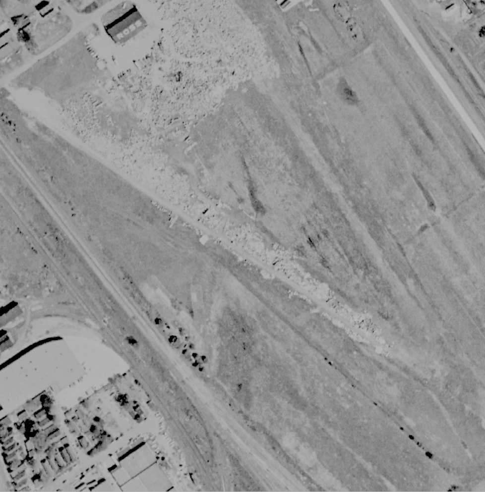
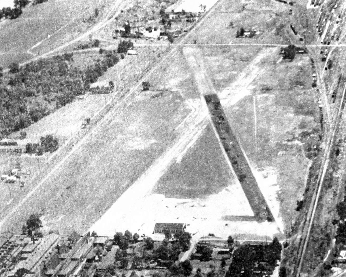
The last photo which has been located of Ross Airport was a 1958 aerial view (courtesy of Albert Stix).
Traces of the 2 runways were still apparently, one of which was being used to store unidentified items.
A single hangar was located on the north end of the field, marked with “Ross” on its roof.
A 1991 USGS aerial view showed no trace remaining of Ross Airport, with the site covered by various industrial buildings.
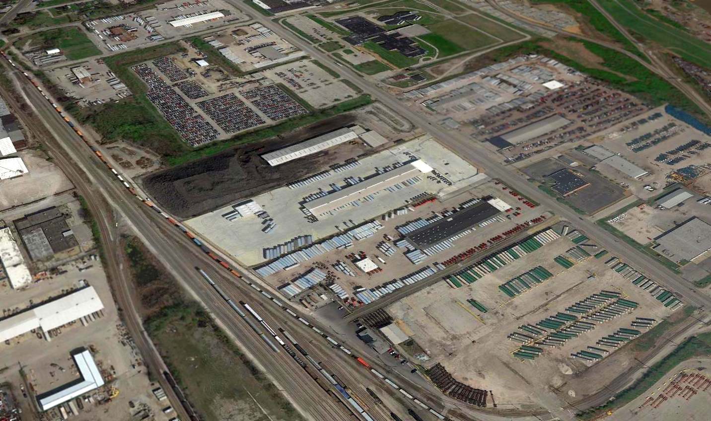
A 2016 aerial view looking north showed no trace remaining of Ross Airport, with the site covered by various industrial buildings.
The site of Ross Airport is located south of the intersection of Thatcher Avenue & Hall Street.
Thanks to Albert Stix for pointing out this airfield.
____________________________________________________
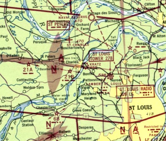
Kratz Field / Suburban Airport, St. Charles, MO
38.78, -90.45 (Northwest of St. Louis, MO)
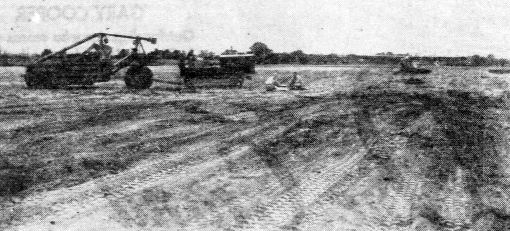
An undated photo from the 7/15/40 St Louis Post-Dispatch (courtesy of Jack Abercrombie) showing construction for Kratz Field, with one single-engine aircraft already on the field.
An article entitled “Field to Train Flyers to be Ready July 15” in the 6/27/40 St Louis Post-Dispatch (courtesy of Jack Abercrombie) described,
“An airport where Jefferson college students will be trainer under the Government's summer flying training program
is being acquired in St Louis County by the St. Louis School of Aeronautics.
The field, rectangular in shape, lies between St. Charles Road & the Wabash right-of-way, just east of the Missouri River.
There will be about 140 acres.
David Kratz, Vice President of the flying school, said he expected to have the field in condition for training use July 15.”
The earliest photo which has been located of Kratz Field was an undated photo from the 7/15/40 St Louis Post-Dispatch (courtesy of Jack Abercrombie)
showing construction for Kratz Field, with one single-engine aircraft already on the field.
Mike Kratz recalled, “My dad had St Louis Flying Service at Lambert Field.
When the war [WW2] broke out he got a contract to teach new pilots.
The city of St Louis asked him not to teach at Lambert because of the amount of traffic it would bring.
So dad went flying to find a place to train pilots. He found the space which became Kratz Field.
It was an easy drive from Kratz to Lambert where he had a maintenance training [operation] also.”
Kratz Field was not yet depicted on the January 1942 Kansas City Sectional Chart.
Jack Taylor recalled that he learned to fly in 1942 in Piper Cubs at Kratz Field as part of the Navy's V-5 Aviation Cadet training program.
The earliest aeronautical chart depiction which has been located of Kratz Field was on the May 1942 Kansas City Sectional Chart.
It depicted Kratz as a commercial/municipal airport.
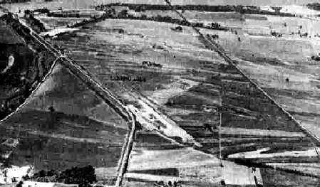
A 10/9/43 aerial view looking north at Kratz Field, from the 1945 AAF Airfield Directory (courtesy of Scott Murdock).
It depicted the field as having an open grass landing area.
The 1945 AAF Airfield Directory (courtesy of Scott Murdock) described Kratz Field
as a 120 acre irregularly-shaped property having a single 2,700' cinder northwest/southeast runway
within a sod all-way landing area, with the longest dimension being 3,000' northeast/southwest.
The field was said to have 2 concrete block hangars, the largest being quite substantial at 324' x 80'.
Kratz Field was described as being owned & operated by private interests.
Mike Kratz recalled, “After the war [WW2] dad... sold the airfield to a lumber company.”
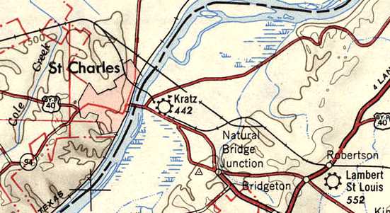
Kratz Field, as depicted in the 1947 USGS topo map.
Note the proximity of St. Louis Lambert Field, which would undoubtedly play a role of the demise of Kratz Field.
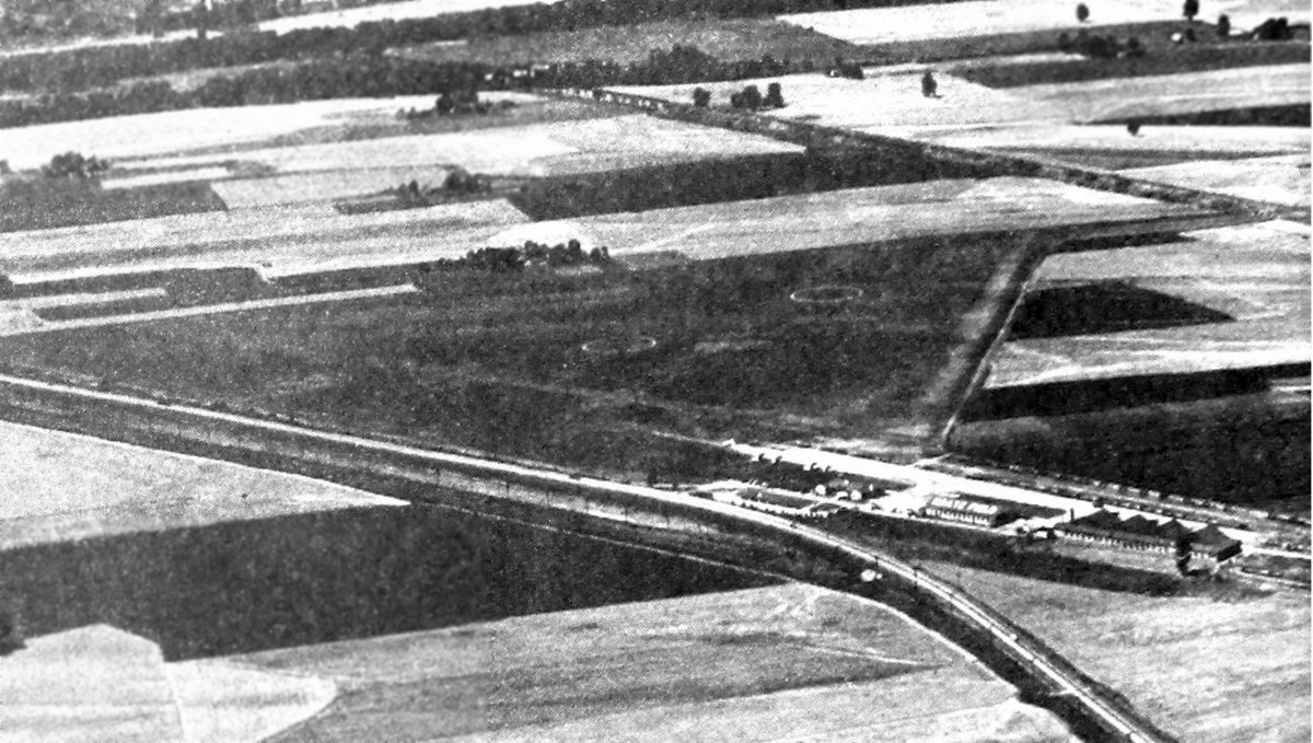
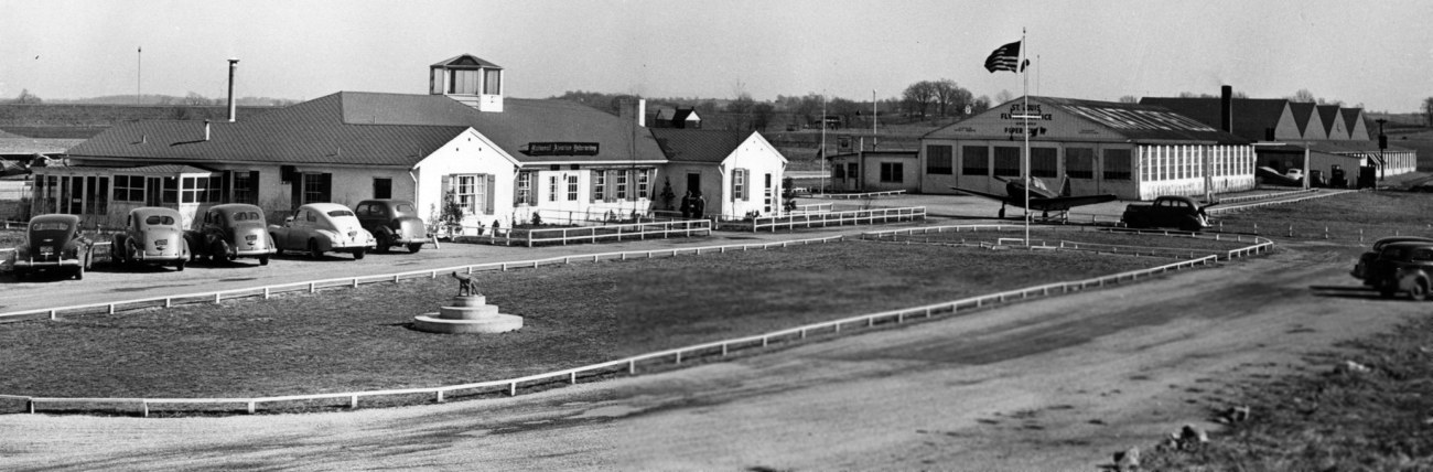
An undated aerial view looking northeast at Kratz Airport from the 1947 MO Airport Directory (courtesy of Joe Gurney).
The directory described Kratz as privately owned, managed by Carl Henke.
It was said to have 3 all-way turf strips, with the longest measuring 3,000' northeast/southwest.
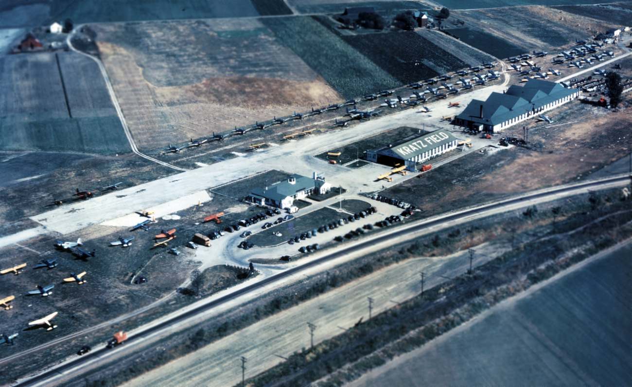
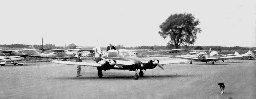
A circa 1940s aerial view looking east at Kratz Field ( from the Greater St. Louis Air & Space Museum archives, courtesy of Jack Abercrombie),
, showing an amazing number of military surplus aircraft, including a B-25 Mitchell bomber.
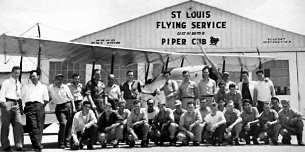
A circa late 1940s / early 1950 picture of Aloys Suhling & fellow students in front of the hangar of St. Louis Flying Service at Kratz Field (courtesy of James Suhling).
James Suhling recalled, “My dad [Aloys Suhling] was a B-17 waist gunner & went to mechanic's school on the G.I. Bill at Kratz.
He graduated from mechanic's school in 1950. The photo is of his class & a Jenny the students worked on.
He always referred to that field as Kratz Flatts. We lived in St. Charles & he drove by that field everyday most of his working life.”
A circa 1940s photo looking east at the buildings of Kratz Field (from the Greater St. Louis Air & Space Museum archives, courtesy of Jack Abercrombie).
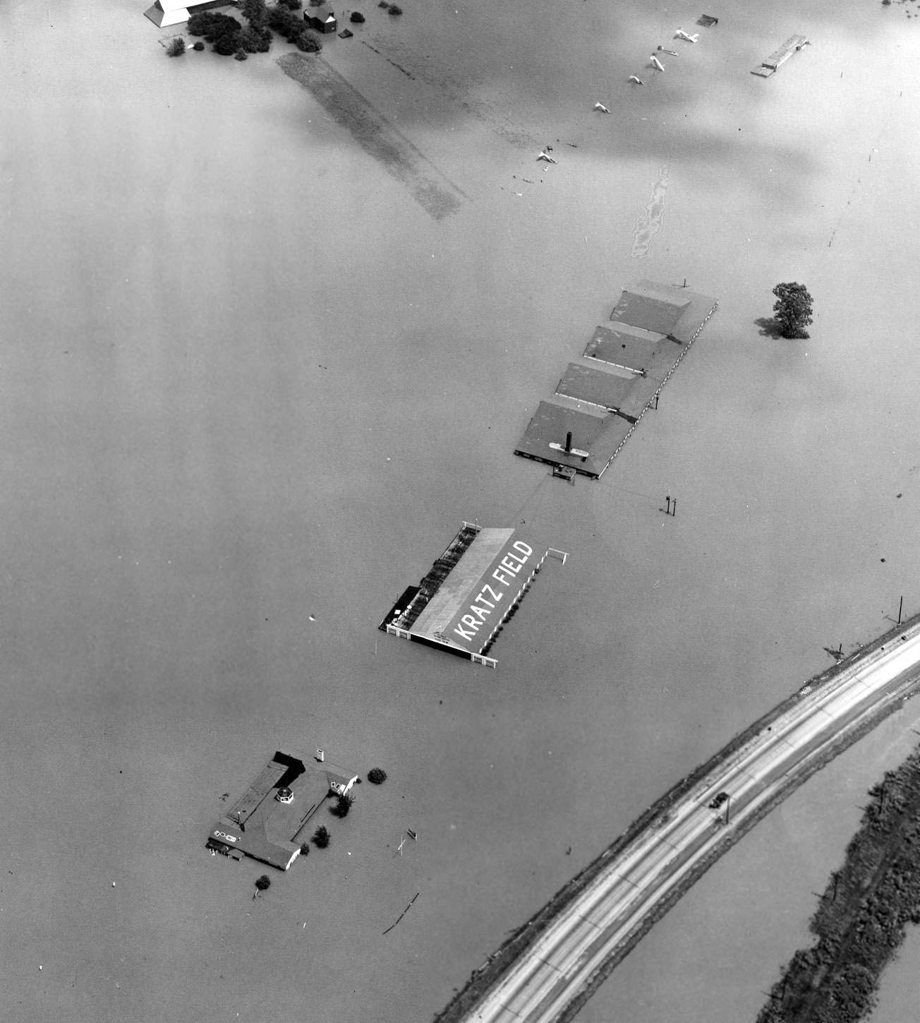
A 1951 aerial view looking east at the flooded Kratz Field (from the Greater St. Louis Air & Space Museum archives, courtesy of Jack Abercrombie).
Jack Abercrombie observed, “Although most of the airplanes got out before a levy break during the Flood of 1951,
there were some remaining on the field in the northeast corner - mostly covered by water.”
A 2/18/54 aerial view looking west at Kratz Field (from the Greater St. Louis Air & Space Museum archives, courtesy of Jack Abercrombie).
Jack Abercrombie observed, “The airport still had not recovered by early 1954.”
The 1954 USGS topo map appeared to depict Kratz Field as having 2 unpaved runways (with a road bisecting the northwest/southeast runway),
and 3 buildings along the south side.
It was still depicted as Kratz Field on the December 1955 Kansas City Sectional Chart.
Kratz Field was evidently renamed Suburban Airport at some point between 1955-56,
as that is how it was labeled on the June 1956 Kansas City Sectional Chart.
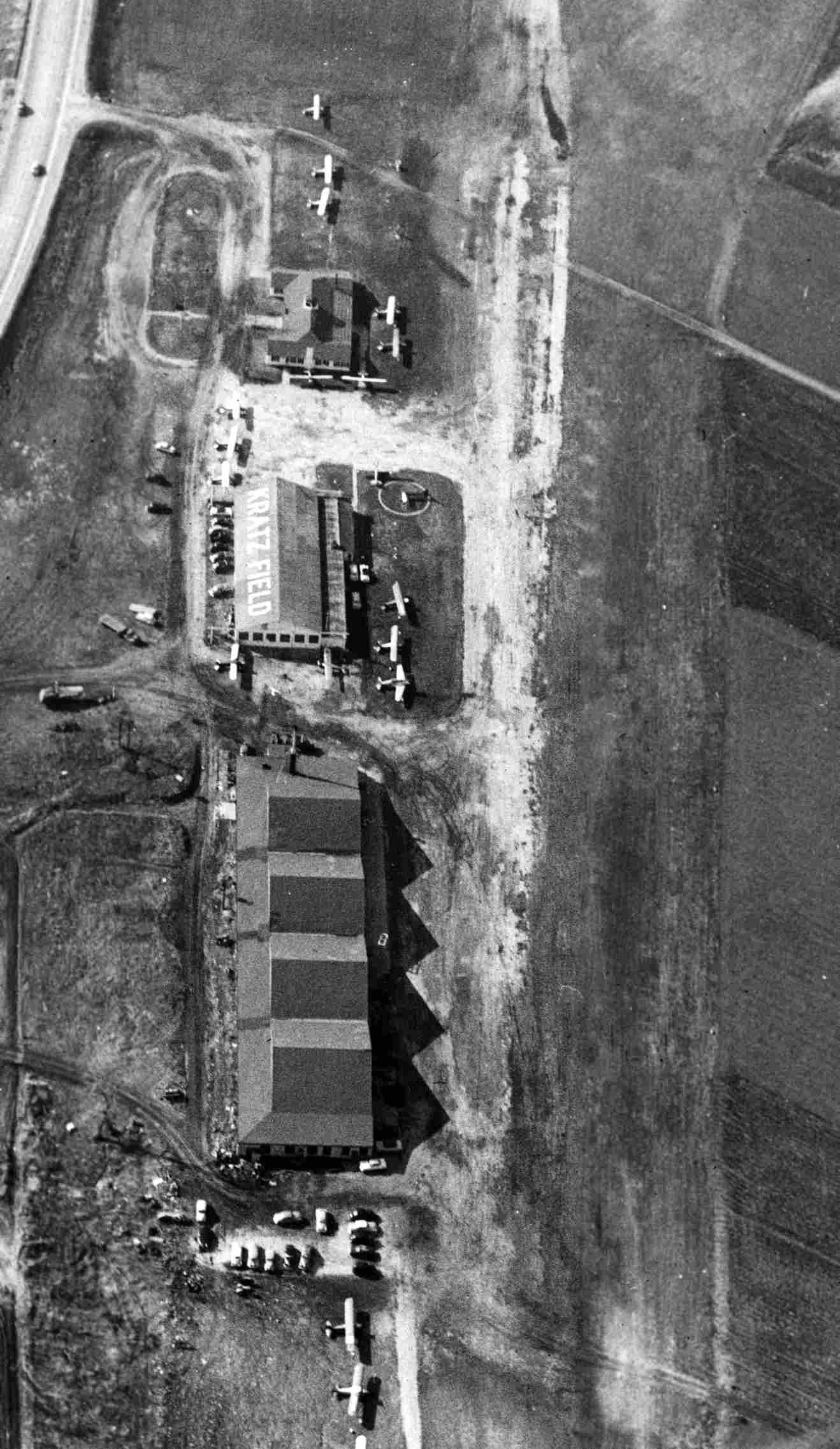
The last photo which has been located of Kratz Field / Suburban Airport was a 1958 aerial view.
It depicted Suburban as having 2 grass runways, with a total of 18 single-engine aircraft parked on the southeast corner.
A complex of buildings was located adjacent to the southeast side, which presumably would have included the large hangars described in the 1945 airfield directory,
but as of 1958 these buildings did not seem to be associated with the airfield.
The last aeronautical chart depiction which has been located of Suburban Airport was on the December 1960 Kansas City Sectional Chart.
It depicted Suburban as a private airfield having a 3,000' unpaved runway.
Suburban Airport was evidently closed (for reasons unknown) at some point between 1960-65,
as it was no longer depicted on the February 1965 Kansas City Sectional Chart or the 1969 USGS topo map.
A 1971 aerial photo shows that several large industrial buildings had covered the Kratz Field site.
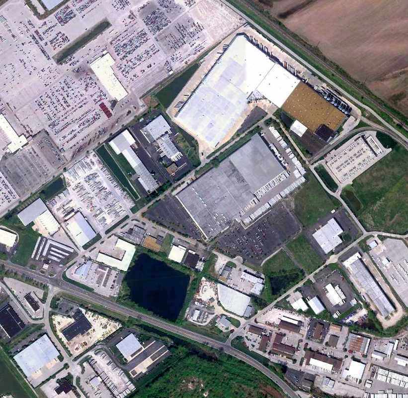
A 4/10/10 aerial view showed several buildings covering the site of Kratz Field, but several hangars remained along the southeast side.
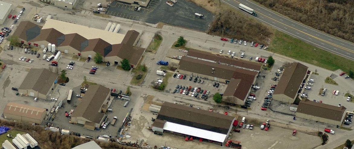
A circa 2010 aerial view looking southeast showed the distinctive 4-peaked roof hangar (also seen in the 1940s photo above) & another adjacent hangar
still remain on the southeast side of the Kratz Field site.
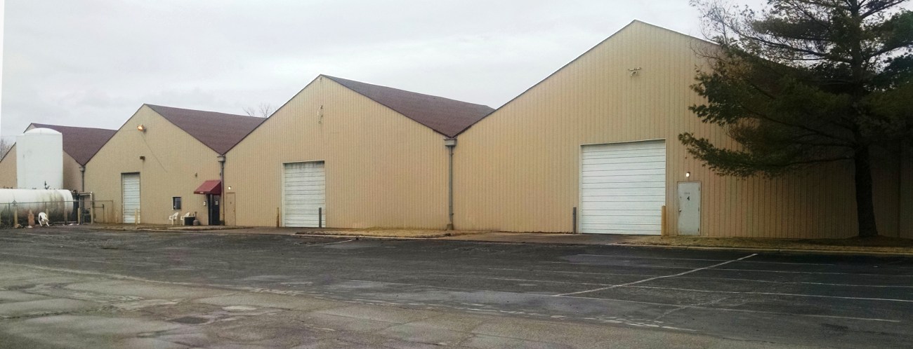
A 2/14/15 photo by Jack Abercrombie looking south at the distinctive 4-peaked roof hangar which remains on the southeast side of the Kratz Field site.
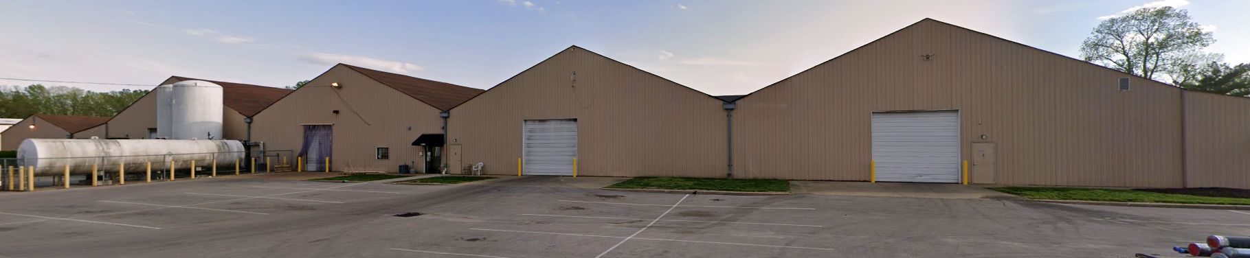
A 2019 photo looking south at the distinctive 4-peaked roof hangar which remains on the southeast side of the Kratz Field site.
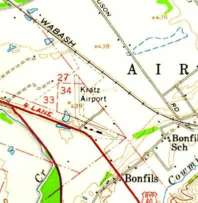
The site of Kratz Field is located north of the intersection of St. Charles Rock Road & Northwest Industrial Court.
Thanks to Albert Stix for pointing out this airfield.
____________________________________________________
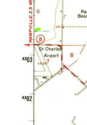
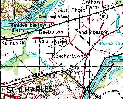
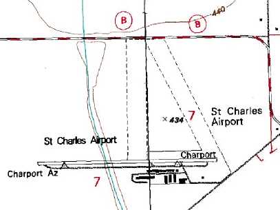
St. Charles Municipal Airport, St. Charles, MO
38.85, -90.5 (Northwest of St. Louis, MO)
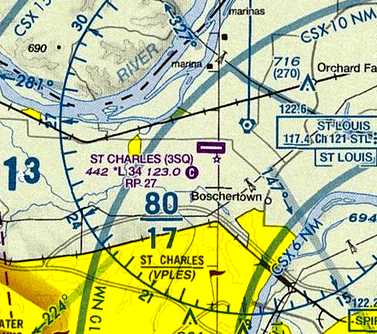
St. Charles Airport, as depicted on the May 1942 Kansas City Sectional Chart.
According to its FAA Airport/Facility Directory data, St. Charles Municipal Airport was established in September 1941.
St. Charles Airport was not yet depicted on the January 1942 Kansas City Sectional Chart.
The earliest depiction which has been located of St. Charles Municipal Airport was on the May 1942 Kansas City Sectional Chart.
It depicted St. Charles as an auxiliary airfield.
The earliest photo which has been located of the St. Charles Municipal Airport
was a 10/9/43 aerial view looking north from the 1945 AAF Airfield Directory (courtesy of Scott Murdock).
It depicted the field as having 2 grass runways with several buildings along the south side.
The 1945 AAF Airfield Directory (courtesy of Scott Murdock) described the St. Charles Municipal Airport
as an 86 acre irregularly-shaped property containing 3 sod runways, the longest being a 3,000' northwest/southeast strip.
The field was said to have 2 hangars, the largest being a 160' x 80' structure.
St. Charles Municipal Airport was described as being owned & operated by private interests.
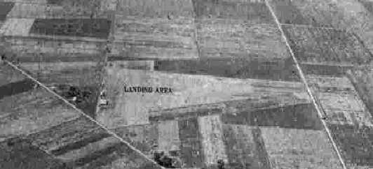
An undated aerial view looking northwest at St. Charles Airport from the 1947 MO Airport Directory (courtesy of Joe Gurney).
The directory described St. Charles Airport as privately owned, managed by Clarence McGarvey.
It was said to have 2 turf strips, measuring 2,850' north/south & 2,060' east/west.
Several hangars & light aircraft were pictured on the south end.
The earliest topo map depiction which has been located of St. Charles Airport was on the 1954 USGS topo map,
which depicted 2 runways & a few small buildings on the southeast side.
The August 1965 Kansas City Sectional Chart (courtesy of Ron Kunse) depicted St. Charles Airport as having a single paved 2,000' east/west runway.
St. Charles Municipal Airport, as depicted in the 1969 USGS topo map.
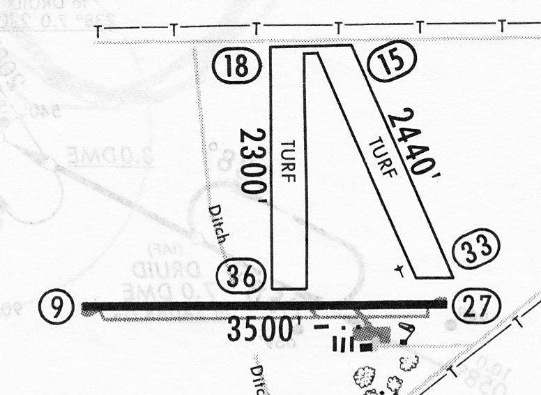
A 12/31/82 airport directory (courtesy of John Kielhofer) depicted St. Charles Municipal Airport as having a single 3,500' paved Runway 9/27, along with 2 grass runways,
and 8 small buildings & a ramp on the southeast side.
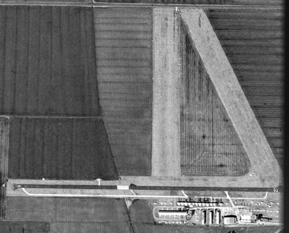
The 2/20/90 USGS aerial view showed St. Charles Municipal Airport as having gained a paved runway at some point between 1945-90,
with the field having a single paved Runway 9/27, along with 2 grass runways.
A large number of hangars & light aircraft were visible on the southeast side of the field,
and one aircraft is visible on short final for Runway 9.
The 1994 USGS topo map depicted St. Charles Municipal Airport as having a single paved Runway 9/27, along with 2 grass runways.
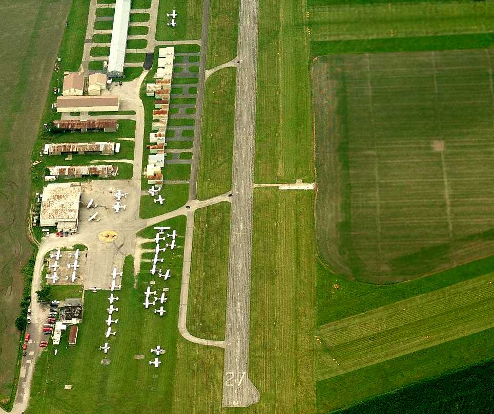
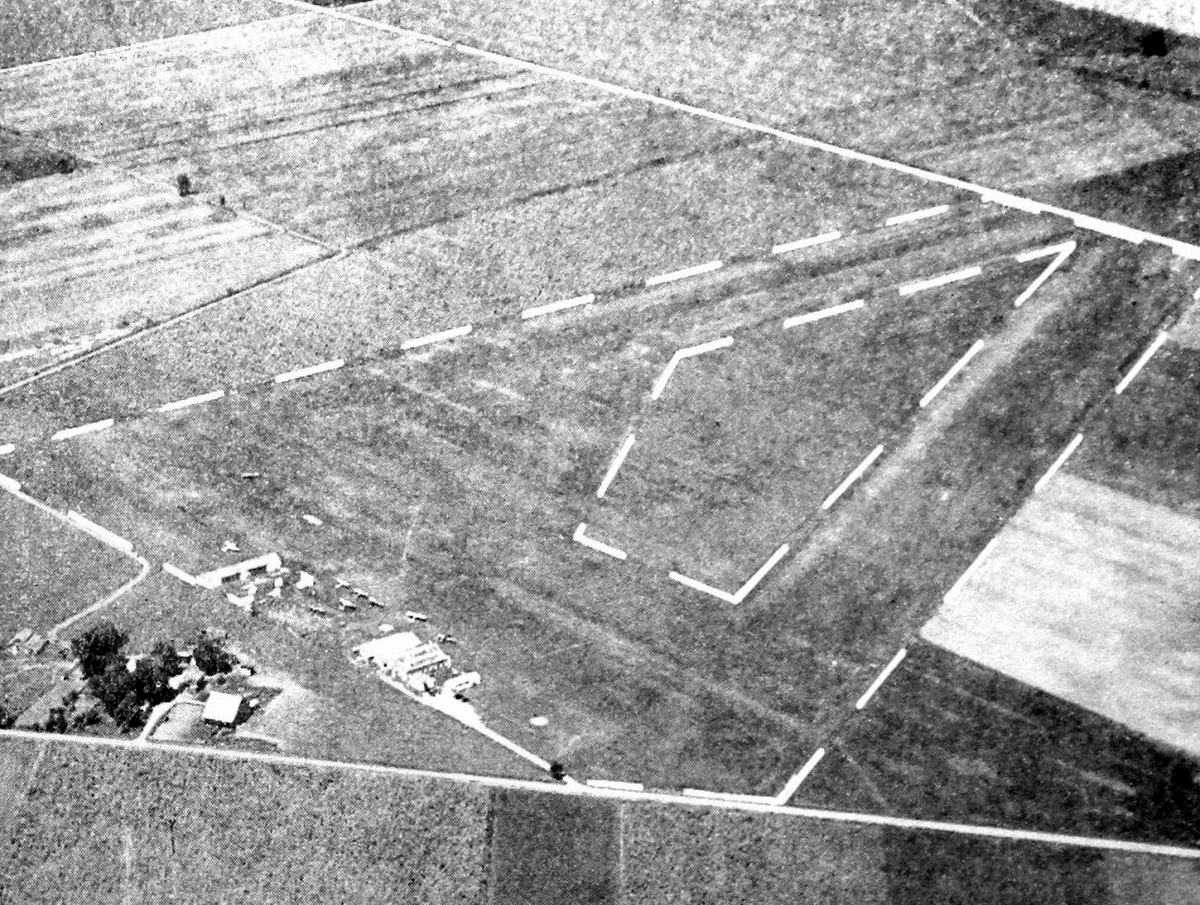
A circa 2000s aerial view looking west along St. Charles' Runway 27 depicted a large number of light aircraft on the field.
A 4/10/10 aerial view depicted St. Charles Municipal Airport in a declining state of health, with only 7 light aircraft visible on the field.
The 2 grass runways were still largely intact, but portions had been reused for some undetermined purpose.
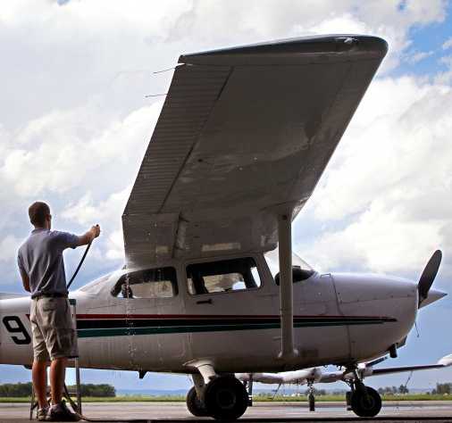
A 5/3/10 photo by Christian Gooden of Chris Langenderfer, a line serviceman at St. Charles Municipal Airport, washing a Cessna 172.
The July 2010 St. Louis Terminal Aeronautical Chart depicted St. Charles Municipal Airport as having a single paved east/west 3,400' runway.
In its last year of operation (2010), the FAA Airport/Facility Directory data
listed a total of 60 aircraft as being based at the St. Charles Municipal Airport,
and described the field as conducting an average of 100 takeoffs or landings per day.
The owner was listed as PFA Associates, with the manager as Dennis Bampton.
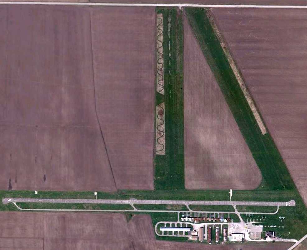
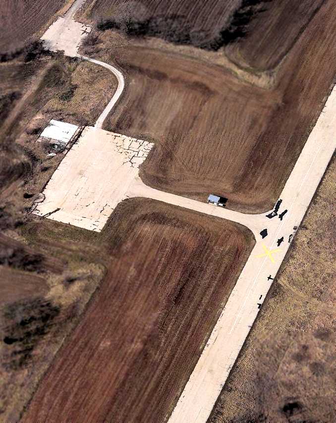
A 6/23/10 aerial view depicted yellow closed-runway “X” symbols on all 3 runways at St. Charles Municipal Airport,
and only 1 light single-engine aircraft still visible on the field.
St. Charles Municipal Airport closed 6/29/10.
According to AOPA, “AOPA had worked with the Airport Support Network volunteer
and talked to the state & local fixed-base operator, St. Charles Flying Service, to try to save the field.
However, the privately owned, public-use airport had no federal or state grants that would have obligated it to remain open.
According to the FAASTeam, St. Charles Flying Service will relocate to St. Charles Smartt Field.”
"As of midnight tonight, the airport is officially closed," said the airport manager, Dennis Bampton.
According to a 6/30/10 St. Louis Today article, “Per federal regulations,
giant 10' x 60' white X's have been painted onto the airport's lone asphalt runway
to ward off landings by pilots who for some reason might not have heard about the shutdown.
Large yellow nylon X's are affixed to Municipal's 2 grass runways.
Bampton said a majority of the 90 or so small planes based at Municipal have moved to Smartt Field,
the county-owned airport a few miles to the northeast, over the past few weeks.
The others have found new homes at other general aviation airports across the metro area.
The ex-Municipal contingent at Smartt includes 22 planes associated with Bampton's St. Charles Flying Service -
a flight school & fueling & maintenance operation that just completed its move on Tuesday.
By Wednesday afternoon, Bampton said, only 2 planes remained on Municipal property.
Their owners plan to fly out before midnight, he said.
Bampton said he still has not been told about plans for the land by the site's owner -
a company made up of St. Louis County businessman Robert Baudendistel & family members.
The family also owns about 1,200 nearby acres, much of it in the Mississippi River flood plain.
Municipal has been the subject of development rumors for years because of its proximity to Highway 370 just west of the St. Charles city limits.”
A 2011 aerial view showed most of St. Charles Municipal Airport's hangars had been removed.
A 2012 aerial view showed the runway pavement of the former St. Charles Municipal Airport Runway 9/27 had been removed.
A 2019 aerial view shows the St. Charles Municipal Airport paved Runway 9/27 had been removed, along with most of the hangars.
Traces of the 2 former grass runways were still recognizable.
A 10/31/20 aerial view looking northeast by Pierre Moser showed the former hangars which remained at the site of St. Charles Municipal Airport.
Behind the hangars, there is only the faintest trace of the 3 former runways.
A 2022 photo looking northwest at the former hangars which remained at the site of St. Charles Municipal Airport.
The site of St. Charles Municipal Airport is located west of the intersection of New Town Boulevard & State Highway B.
____________________________________________________
E W Cotton Woods Memorial Airport (K24), Columbia, MO
39, -92.3 (West of St. Louis, MO)
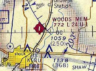
Woods Memorial Airport, as depicted on the July 1973 Kansas City Sectional Chart (courtesy of Chris Kennedy).
No airfield was yet depicted at this location on the February 1969 Kansas City Sectional Chart.
Woods Memorial Airport was built by Nancy Woods Badger, opening the field on 6/15/71 (according to Eli Hoff).
According to Andy Kendig, after the Columbia Municipal Airport closed in the 1970s,
an FBO owner opened Cotton Woods airport to have a general aviation-friendly airport
located closer to town than the new Regional Airport 13 miles out.
The earliest depiction which has been located of Woods Memorial Airport was on the July 1973 Kansas City Sectional Chart (courtesy of Chris Kennedy).
It depicted Woods Memorial Airport as having a single 2,400' paved north/south runway.
The earliest photo which has been located of Woods Memorial Airport was a 3/26/74 USGS aerial view.
It depicted Woods Memorial Airport as having a paved northeast/southwest runway, a grass northwest/southeast runway,
and a large number of aircraft parking spots & aircraft on the northwest side.
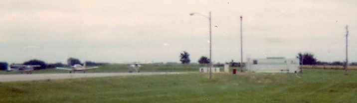
A 1976 aerial view looking south at Cotton Woods Airport while on approach to Runway 18.
A 1978 photo of Cotton Woods Airport by Rick Morgan.
The Piper Warrior is sitting in front of the FBO, which was on the northwest corner of the field.
A 1978 photo of Cotton Woods Airport by Rick Morgan.
The time exposure shows an aircraft taking off to the south, towards Columbia.
Dean Cook recalled, “E.W. Cotton Wood Memorial Airport... I worked for the Fixed Base Operator company,
Columbia Flying Service, from 1979-82 as a lineman. My brother also worked there in 1978-79.
Columbia Flying Service was a thriving company during the mid-1970s
offering flight training, aircraft maintenance, fuel sales, charter flights & running a Piper Aircraft dealership.
The company was owned by a group of medical doctors & at least one PHD from the University of MO.
At some point just prior to when I was hired in late 1979, the Piper dealership was shut down but the other activities continued despite a gradual decline in business.”
Dean continued, “At the time I worked there, the company still owned & operated 4 Cherokee 140s & a Piper Arrow IV for flight training.
Also available for rent were several leaseback aircraft including an Archer, another Arrow, a Cherokee 6, a Lance, and a Seneca.
There were also 15-20 other based aircraft including a small university flying club.”
Dean continued, “As a low-level employee I was not privy to the exact details but the company was struggling to stay afloat in 1980-81.
There were occasions we would run short on fuel & be unable to afford to purchase another truckload
and I think on a few occasions some of the owners had to pony up for company expenses out of their own pocket.
During this time, there was an attempt to extend the runway from 2,400’ to around 4,000’.
The landowner already owned the land to the north of the runway needed to make this expansion but it was not zoned for commercial use.
In the 10 year existence of the airport, the city of Columbia had substantially expanded
and the airport which had once sat a couple of miles north of the nearest edge of the city was now surrounded by housing.
The attempt to re-zone the land for the runway extension failed.”
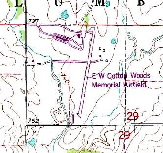
The 1981 USGS topo map depicted EW Cotton Woods Memorial Airfield as having a paved northeast/southwest runway,
and several small buildings on the northwest & northeast sides.
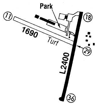
E W Cotton Woods Memorial Airport was listed in the 1982 AOPA Airport Directory (courtesy of Ed Drury).
It described the field as 2,400' asphalt Runway 18/36 & a 1,800' turf Runway 10/28.
The operator was listed as Columbia Flying Service.
Dean Cook recalled, “Columbia Flying Service made a final attempt to stay in business by moving its operations to Columbia Regional Airport in 1982.
After the departure of the FBO from Cotton Wood, a few aircraft remained based at the field despite the lack of available fuel or any maintenance to the field.
There was one attempt to run an FBO by a local cropduster sometime in 1983 or 1984.
After that, the former head Airframe & Powerplant mechanic for Columbia Flying Service returned to the field, partnered with a flight instructor.”
Cotton Woods Memorial Airport was still depicted as an active airport in the 1986 Flight Guide (courtesy of Chris Kennedy).
Brian Bowman recalled, "I had a Taylorcraft based there from 1985-90.
The gentleman that ran the FBO & was the A&P there had a fatal accident in his Citabria [on 10/14/87, according to the NTSB].
Apparently the elevator cable was able to contact one of the posts of the battery terminal & spot-welded itself in a frozen position.
The plane crashed & a big fire ensued. The pilot (and I seem to remember a passenger?) perished.
No one else wanted to run the place I guess,
and the City of Columbia / County of Boone was looking for a new fairground site since the old site had been swallowed up by suburbia."
The Cotton Woods Memorial Airport was evidently closed in 1990.
In the words of Rick Morgan, "This was a really pleasant little airport- it's a shame its gone now."
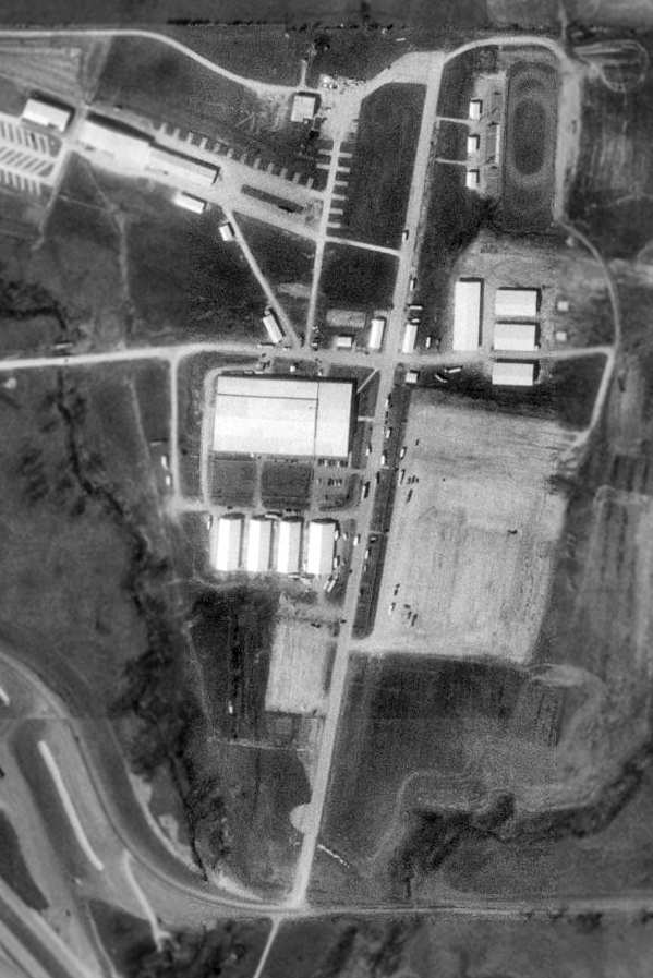
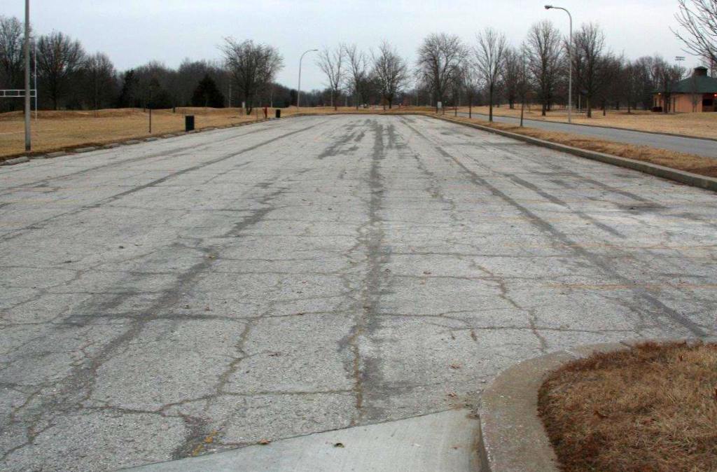
As seen in the 1995 USGS aerial photo, the site of Woods Airport has been reused as the county fairgrounds.
The paved runway still existed, and has been reused as a road. The beacon & hangars also remained.
A circa 2006 aerial view looking north at the site of the Woods Airport showed that the hangars had been removed at some point between 1996-2006.
The runway pavement, ramps, and hangar foundations still remained though.
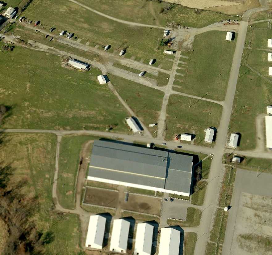
A 2022 photo looking northeast along the former Woods Airport Runway 36, now reused as a street in the Northeast Events Center.
The site of Woods Airport is located northeast of the intersection of Route 63 & East Starke Avenue.
____________________________________________________
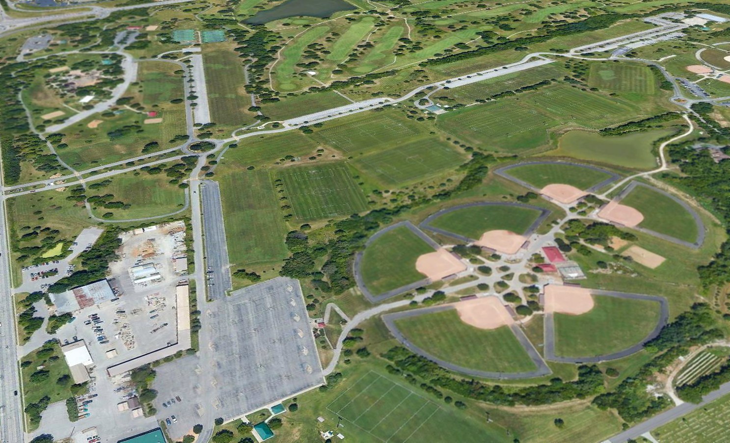
Lake Winnebago Municipal Airport (MO8), Lake Winnebago, MO
38.81, -94.31 (Southeast of Kansas City, MO)
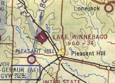
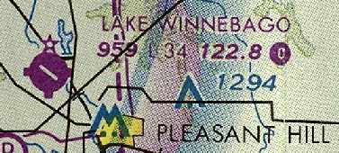
Lake Winnebago Airport, as depicted on the August 1967 Kansas City Sectional Chart (courtesy of Chris Kennedy).
Photo of the airport while open has not been located.
Tom Reardon recalled, "My father, Joe Reardon, was the city engineer & director of public works
for the Village of Lake Winnebago from 1963-70.
The airport property runs adjacent to the rock quarry
and was originally purchased from them in 1964 by Robert Steinhilber (the developer) to build the airport.
The airport planning & approval was done in 1965 with construction beginning in 1966.”
Lake Winnebago Airport was not yet depicted on the February 1967 Kansas City Sectional Chart.
Tom Reardon recalled, "The city always owned the airport & leased facilities to Midwest Executive Aircraft.
The project was completed in mid 1967 with great fanfare.”
Robert Steinhilber recalled, “I have an 8mm film of the landing & takeoff of the first plane to do so at the airport - the pilot was my wife, Joan.
She secretly got her pilot's license while I was busy with the airport construction & other Lake Winnebago work,
and I did not know about it until just before we completed the airport.
When I found out, I made arrangements for her to be the first to land & take-off.”
Tom Reardon recalled, "“It should be noted that this airfield was lighted, well planned, state of the art & built to last.
A lot of thought went into the project.
As you drove into the entrance from Highway BB, you were greeted by the official Lake Winnebago stone gates.
There was a long sweeping drive up to the parking lot. From the parking lot, a service drive took you to the ramp.
We had a small 40 foot mobile home set up at the southwest corner of the ramp as our operations center.
The trailer was formerly a General Electric show unit to display the latest in home lighting.
It worked great for our needs. Just west of the office was a pump island for 80 & 100 octane fuel.
There were about 20 tiedown spots available & at that time we had about a dozen aircraft based there.
Piper was the most dominant model with several Cherokees & Comanche's on chains.
I recall a TriPacer, Stinson & a couple of Skyhawks based with us."
The earliest depiction of the Lake Winnebago Municipal Airport which has been located
was on the August 1967 Kansas City Sectional Chart (courtesy of Chris Kennedy).
It depicted the field as having a single 3,400' paved runway.
Tom Reardon continued, "General aviation was booming back in the late 1960's
and those building in the exclusive Village of Lake Winnebago had the means to own & operate aircraft.
As I recall there were several TWA pilots who had just built homes & moved into the community
as well as a couple of players for the Chiefs."
A 1969 photo of Lake Winnebago Airport by Tom Reardon.
"Here Max is heading back to the office after greeting an arrival."
Tom Reardon continued, "During the summer of 1969, a builders strike crippled lake home development.
I worked with my dad that summer at the airport helping out where I could.
I was 11 & had a terrific summer as a line boy & gofer.
I recall that we had a fly-in that summer & it attracted a lot of attention.
Our airport dog, Max greeted the arrivals
and we always had sodas, candy bars & ham sandwiches available for the hungry traveler.
For a little podunk airport, we kept pretty busy in those days."
A late 1970 photo of Lake Winnebago Airport by Tom Reardon.
"You can make out the trailer, gas pumps, and beacon."
Tom Reardon recalled, "The future looked very bright for this airport when we moved on in 1970."
The 1982 AOPA Airport Directory (courtesy of Ed Drury)
described the Lake Winnebago Municipal Airport as having a single 3,400' asphalt Runway 11/29,
and listed the operator as Midwest Executive Aircraft Inc.
The last aeronautical chart depiction which has been located of Lake Winnebago Airport was on the July 1989 Kansas City Sectional Chart (courtesy of Timothy Aanerud).
It depicted Lake Winnebago Airport as having a single 3,400' paved runway.
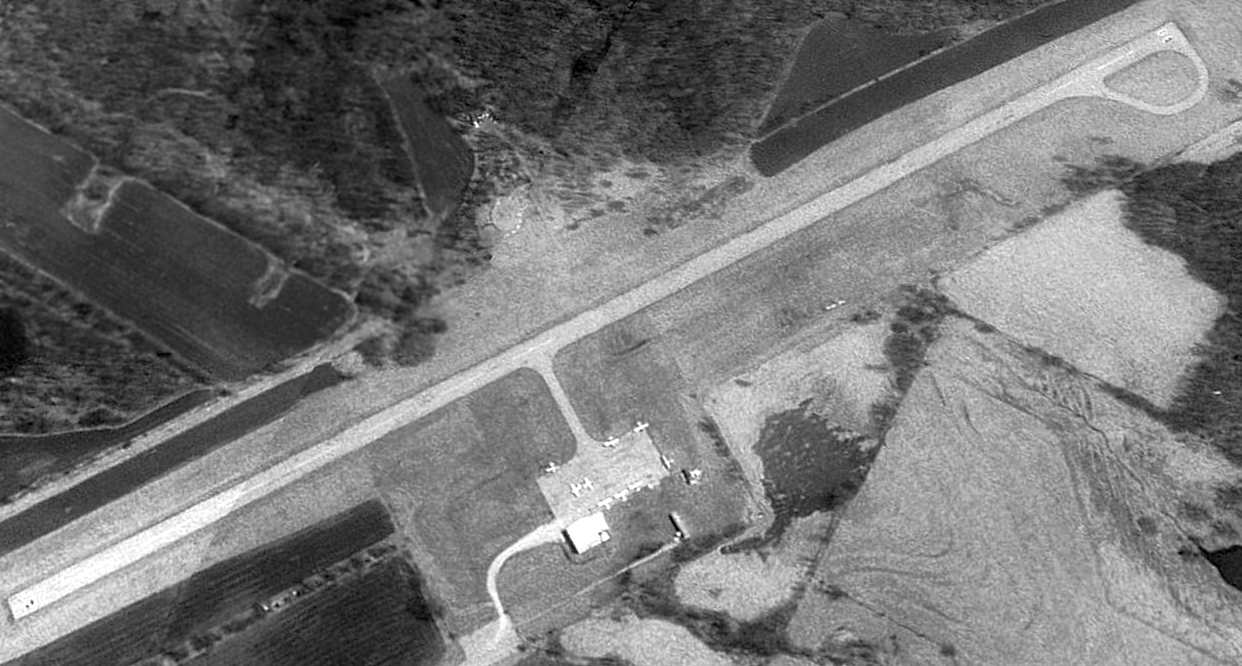
The last photo which has been located showing Lake Winnebago Airport still open was a 1990 USGS aerial view looking northeast.
It showed the little airport to be quite popular, with 9 light single-engine aircraft parked on the ramp.
According to Tom Reardon, “Around 1994, Lake Winnebago sold the property back to Martin Marietta Aggregates.”
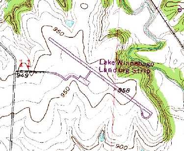
The 1995 USGS topo map depicted “Lake Winnebago Landing Strip” as having a single paved northwest/southeast runway, with a ramp on the south side.
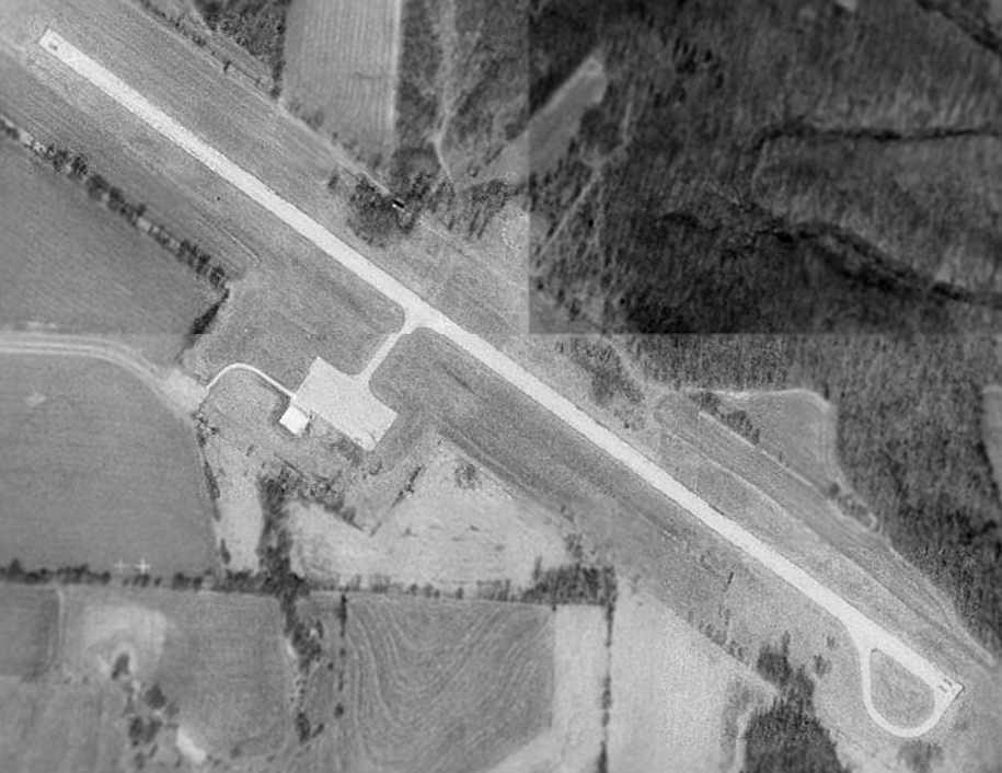
Lake Winnebago Airport was evidently closed at some point between 1990-96,
as a 1996 USGS aerial photo showed the runway numbers had been painted out, and a closed-runway "X" was faintly visible on the northwest end of the runway.
The hangar had also been removed, but the paved runway & ramp remained otherwise intact.
Lake Winnebago Municipal Airport was not listed among active airfields in the 2000 AOPA Airport Directory,
and it was depicted as an abandoned airfield on the 2003 Sectional Aeronautical Chart.
Tom Reardon continued, "I am not sure what led to the closing of the airport.
I understand from locals in the Lee's Summit area that the City sold the property to a private party
to spare the town the expense of maintaining the field.
This makes sense if it closed in the early 1990's as the recession pretty much crushed most small operators.
A municipal airport with no commercial or industrial value would have been an expensive & unused liability
to a struggling community the size of Lake Winnebago.
This experience led me into my 20 plus year career in General Aviation.
I owe a lot to that little airport, my dad & the experience.
Hopefully, someday, someone will see the value in reopening it to the public."
Robert Steinhilber recalled, “What happened to the airport & industrial park is disgusting,
and you can thank a couple of disgraceful federal judges & their favorable attorneys for that.”
Noah Dunker reported in 2004, "I called Midwest Executive Aircraft [former operator of the airport] to inquire about the airfield site.
They've since moved a few miles away to Lee's Summit, but the lady there informed me that they sold it to the city,
which she believes in turn sold it to a rock quarry company."
Tom Reardon reported in 2005, “I visited the site & found the original stone gates, less signage & lights,
with an added iron gate marked 'Private - No Trespassing'.
The area has overgrown with brush & looks sad. Very heavy mining activity is just northwest of the site.
I have no idea the condition of the airport but it will most likely fall victim to the earth movers if it hasn't already.
Too bad about the airport. Sounds like the rock it was built on has more value today.
It is a strange world we live in these days.
It was a great idea & would have survived if the halcyon days of affordable flying were still with us.”
A circa 2006 aerial view looking west at the remains of the Lake Winnebago Airport runway, ramp, and a building foundation.
A 2/12/12 photo by Floyd Taber looking along the remains of the Lake Winnebago runway.
Floyd observed, “I couldn’t stand not driving back there & seeing the place. It seemed so surreal to be there.
A 4 inch overlay of asphalt & we would be back in business.
All the infrastructure has been removed right down to the poles that supplied electricity to the place.
Looks like its being used for an ultralight plane now & then.”
A 2/12/12 photo by Floyd Taber of the remains of a Lake Winnebago ramp or foundation.
In contradiction to earlier reports, a 2019 aerial view looking northeast showed the former Lake Winnebago Municipal Airport has remained basically unchanged for at least 23 years, with no redevelopment,
making one wonder why the airport ever had to be closed in the first place.
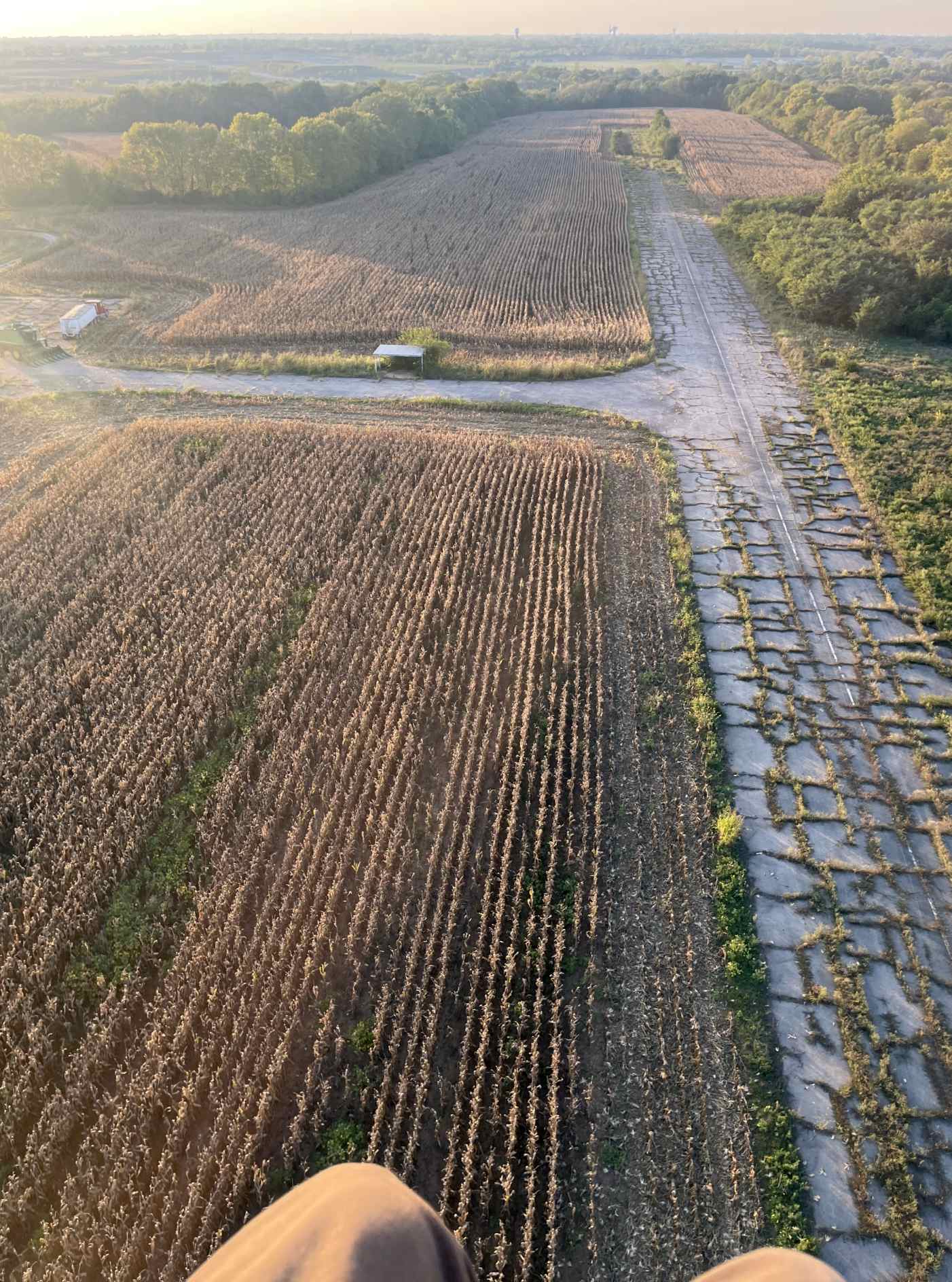
A 10/1/23 aerial view by Thor Shelton looking northwest from his paramotor at the remains of the Lake Winnebago Airport runway, ramp, and a small building.
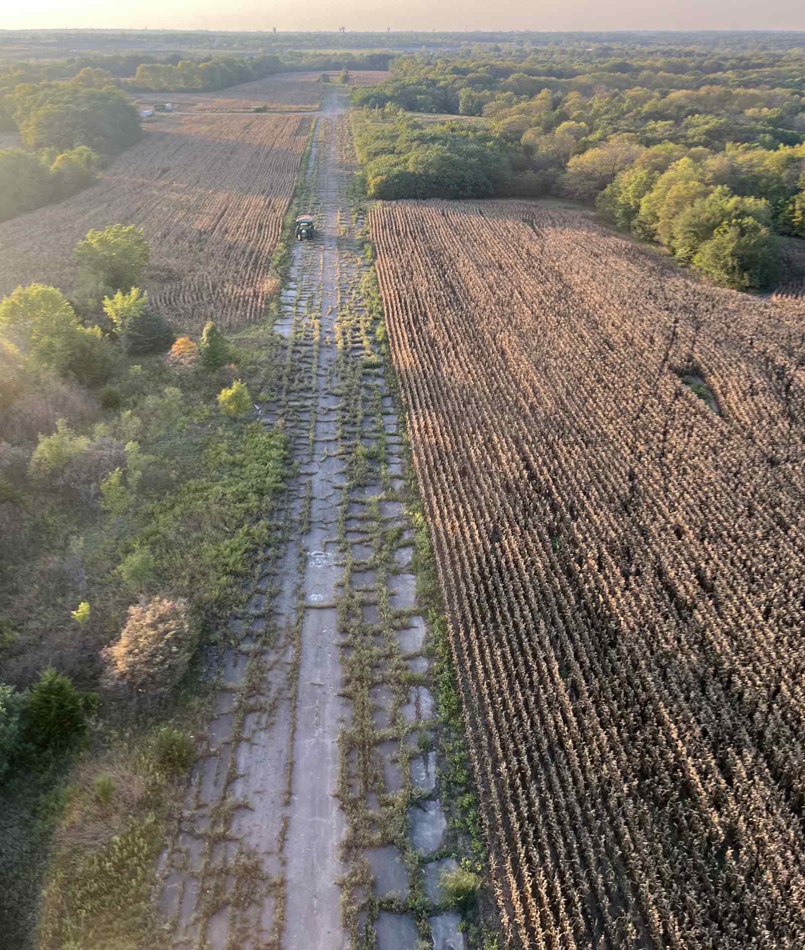
A 10/1/23 aerial view by Thor Shelton looking northwest from his paramotor at the remains of the Lake Winnebago Airport runway.
The Lake Winnebago Municipal Airport is located southeast of the intersection of East 163rd Street & Airport Road (appropriately enough).
Thanks to Chris Kennedy for pointing out this former airfield.
____________________________________________________
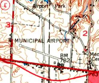
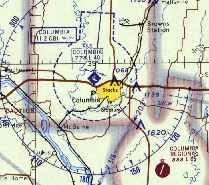
Columbia Municipal Airport (CBI), Columbia, MO
38.97, -92.36 (West of St. Louis, MO)
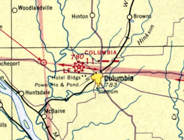
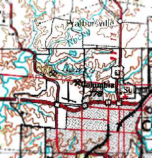
Columbia Airport, as depicted on the May 1939 Kansas City Sectional Chart.
This municipal airport on the northwest side of Columbia was evidently established at some point between 1932-39,
as it was not yet depicted on the June 1932 Kansas City Sectional Chart.
The earliest reference which has been located to Columbia Municipal Airport
was in The Airfield Directory Company's 1938 Airports Directory (according to Chris Kennedy).
The earliest depiction which has been located of Columbia Airport was on the May 1939 Kansas City Sectional Chart.
According to connectmidmissouri.com, Stephens College offered a flying school at Columbia Airport starting in the 1940s.
A view looking southwest at Columbia Airport from the 1947 MO Airport Directory (courtesy of Stephen Mahaley).
The field was described as having 3 runways: an east/west 3,300' macadam runway, a north/south 3,100' macadam runway,
and a northeast/southwest 1,600' sod strip.
At least 2 fairly substantial hangars were pictured in the 1947 photo. The manager was listed as Robert Selfridge.
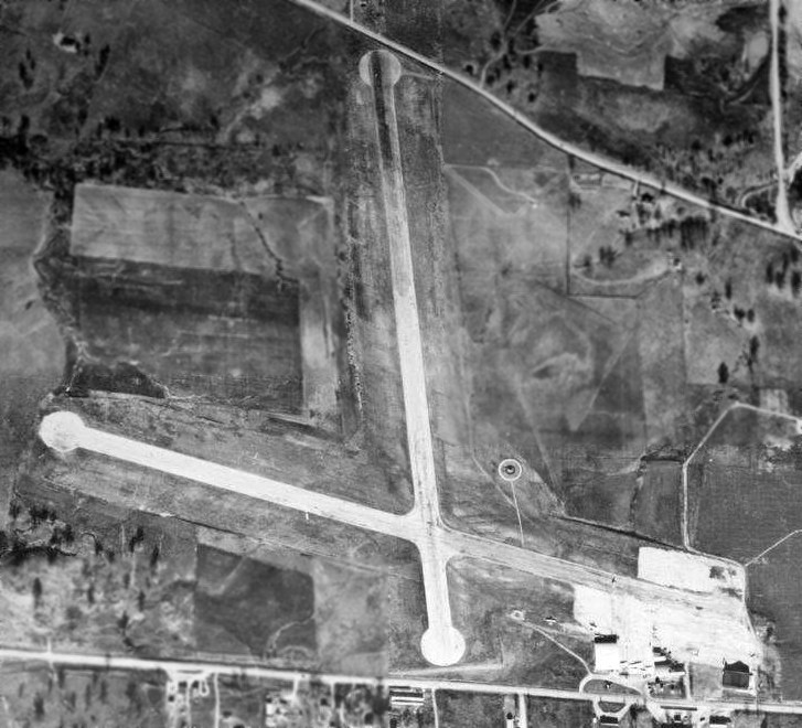
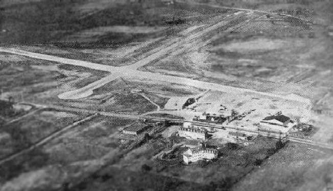
A circa 1940s aerial view of Columbia Municipal Airport showed 2 paved runways, and 3 light aircraft near the hangars on the southeast side.
The picture was found by David Brooks in 2014 on the wall of the offices of the Columbia Parks Department, which occupies the airport site.
The 1948 Kansas City Sectional (according to Chris Kennedy) described Columbia as having a 3,300' unpaved runway.
The 1948 USGS topo map depicted Columbia Municipal Airport as having 2 paved runways
and a ramp with a few small buildings at the southeast corner of the field.
Chuck Crisler recalled “visits to Columbia when I was a kid in the 1950s & early 1960s.
My grandfather would take us out to visit his old buddies. One of those buddies was Cotton Woods at the old airport.
I have an image of him in my head wearing coveralls & having his arms up to the elbows covered in grease, stopping what he was doing to visit with us.
The smell was probably the lacquer they used to coat the fabric on the wings of postwar Piper Cubs.
My first airplane trip was also out of there on an Ozark DC-3 headed to a connection in St Louis, likely in the early 1960s.
I remember being shocked at how steep the aisle was getting up to my seat.
The
stewardess handed out gum & watermelon-flavored candies to the
passengers to help pop your ears from the unpressurized cabin.
As
an impressionable kid, those kinds of things stuck in mind, and later
led to getting a private pilots license & owning light
single-engine aircraft later in life.”
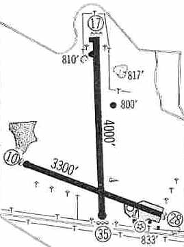
The 1960 Jeppesen Airway Manual (courtesy of Chris Kennedy) depicted Columbia as having 2 paved runways: 4,000' Runway 17/35 & 3,300' Runway 10/28.
A ramp with a few small buildings was at the southeast corner of the field.
By the time of the 1962 AOPA Airport Directory the field consisted of 2 bituminous runways: 4,000' Runway 17/35 & 3,300' Runway 10/28.
The operator was listed as Columbia Air Service.
Chuck Crisler recalled “I returned to Columbia in 1966 as a college freshman at the university.
By
then the busy road out front was expanded & you could already
feel the commercial encroachment.”
According to former MO resident Rick Morgan, Ozark Airlines moved their service from Columbia Municipal Airport
to the new larger Columbia Regional Airport October 1968.
"CBI's short runways was why they kept DC-3s in service up to that date. I'm not sure it stayed open much longer."
According to connectmidmissouri.com, Stephens College ended their flying school at Columbia Airport in the 1960s.
The last aeronautical chart depiction which has been located of Columbia Airport was on the February 1969 Kansas City Sectional Chart.
It depicted Columbia Airport as having 2 paved runways, with the longest being 4,000'.
Columbia Municipal was still depicted as an active airport on the 1970 USGS topo map, with 2 runways.
According to Andy Kendig, Columbia Municipal Airport was closed in the early 1970s.
The 1980 USGS topo map depicted the site of Columbia Municipal Airport as a park,
and no longer depicted the former runways at all.
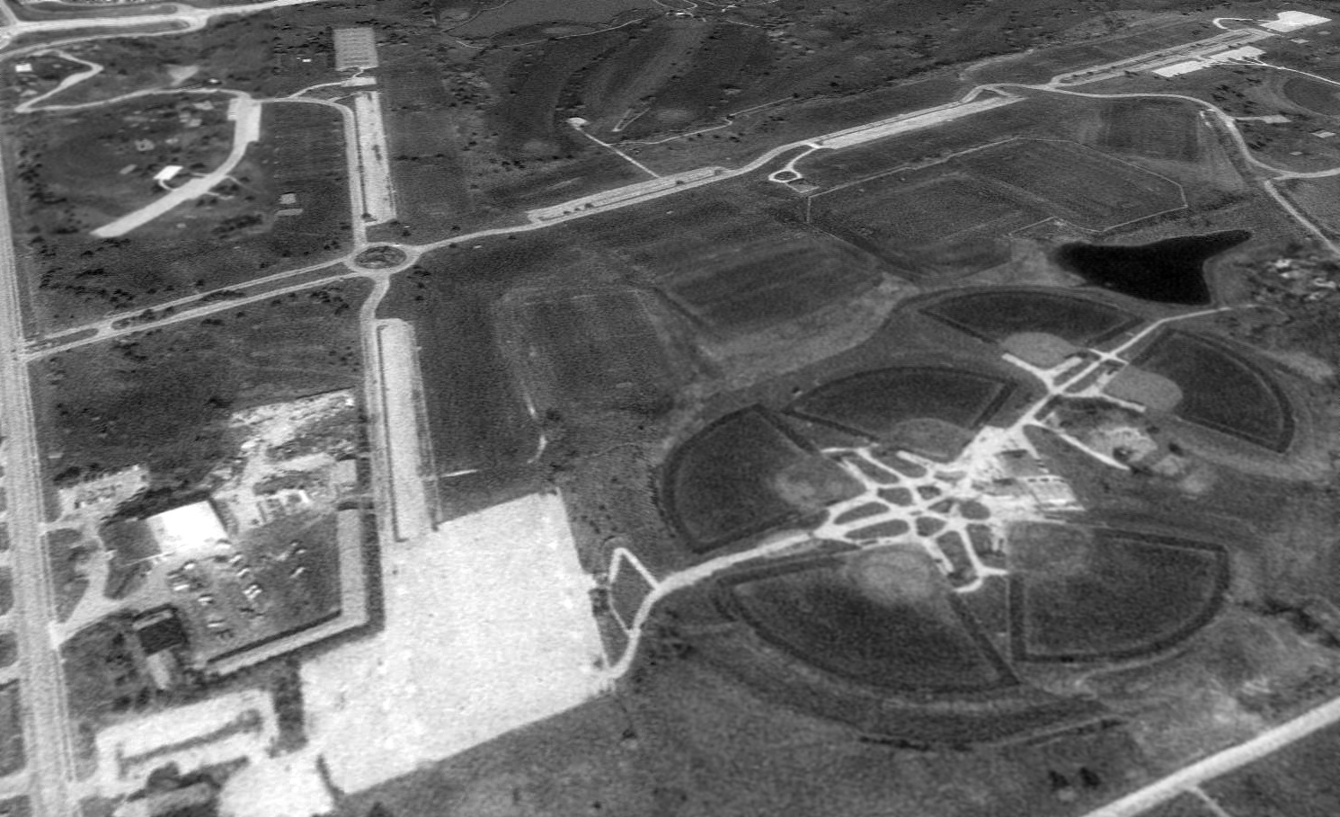
A 1995 USGS aerial view looking northwest showed the former Columbia Municipal Airport runways were largely still intact,
having been reused as parking lots for the Columbia Cosmopolitan Recreation Area.
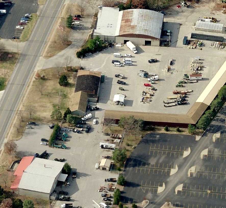
A circa 2006 aerial view looking west at 2 former hangars (top-center & bottom-left of photo)
which remain standing at the southeast corner of the site of the Columbia Municipal Airport.
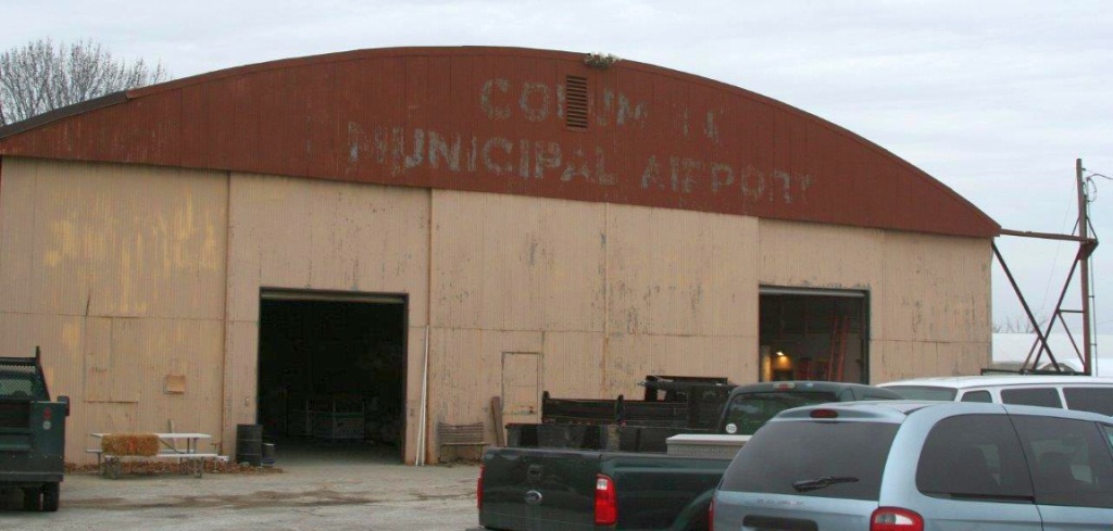
A January 2014 photo by Dick Merrill showing the former hangar which still bears the lettering “Columbia Municipal Airport”.
A January 2014 photo by Dick Merrill showing a former hangar at the site of Columbia Municipal Airport.
A January 2014 photo by Dick Merrill showing “the remains of the north/south runway” at the site of Columbia Municipal Airport.
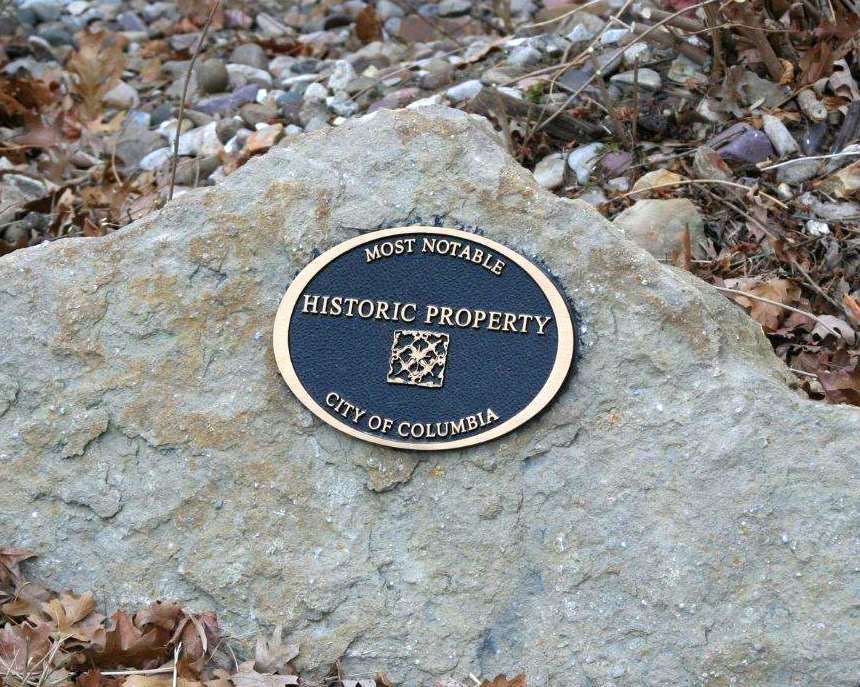
A January 2014 photo by Dick Merrill of a plaque commemorating a “Most notable historic property” at the site of Columbia Municipal Airport.
![]()
A January 2014 photo by Dick Merrill of a rotating beacon tower at the site of Columbia Municipal Airport.
David observed, “I was surprised to see they still had a rotating beacon.
The site is now the offices of the Columbia Parks Department & some of the personnel there told me the beacon was a recent addition
that had been move there from the old Cottonwood Airport that is now the fairgrounds.
The beacon light was missing the lenses & internal bulbs.”
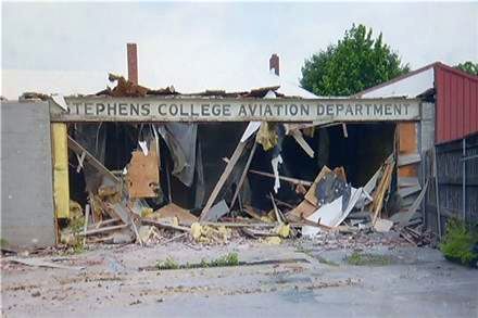
A June 2014 photo (courtesy of Herman Lueckenotte) of a 43' wide steel sign for the "Stephens College Aviation Department"
found hidden by behind some bricks during demolition of a building at the site of Columbia Municipal Airport.
City leaders are working with Stephens College officials to figure out where they want to display the sign.
Columbia Public Works spokesman Steve Sapp said, “Stephens College may have a building coming up where they could repurpose it into that building.
There’s been a lot of talk about either a remodel of the current Columbia Regional Airport terminal or a new terminal.
It could perhaps become an element of the terminal renovation or new terminal.”
City officials hired a tow truck company to move the sign to a maintenance facility building at the Columbia Regional Airport.
The sign is outside and wrapped in a tarp. City officials plan to move the sign indoors sometime next week as they decide on a permanent location.
A 2017 aerial view looking northwest showed the former Columbia Municipal Airport runways remained recognizable.
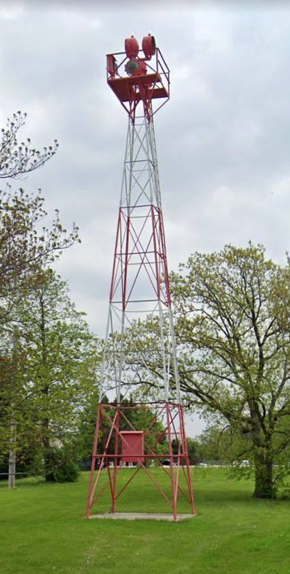
A 2022 photo looking west at the rotating beacon tower which remains on the southern edge of the Columbia Municipal Airport site.
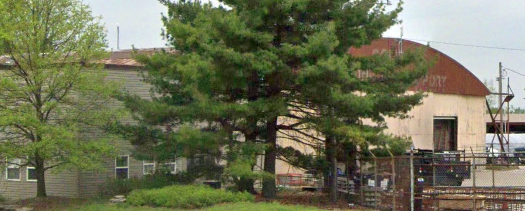
A 2022 photo looking northwest at the former hangar which still bears the lettering “Columbia Municipal Airport”.
The site of Columbia Municipal Airport is located northwest of the intersection of Interstate 70 & Schwabe Lane.
Thanks to Andy Kendig for pointing out this former airfield.
____________________________________________________
Since this site was first put on the web in 1999, its popularity has grown tremendously.
If the total quantity of material on this site is to continue to grow,
it will require ever-increasing funding to pay its expenses.
Therefore, I request financial contributions from site visitors,
to help defray the increasing costs of the site
and ensure that it continues to be available & to grow.
What would you pay for a good aviation magazine, or a good aviation book?
Please consider a donation of an equivalent amount, at the least.
This site is not supported by commercial advertising –
it is purely supported by donations.
If you enjoy the site, and would like to make a financial contribution,
you
may use a credit card via
![]() :
:
Please consider checking the box to make a monthly donatation.
For a mailing address to send a check, please contact me at: paulandterryfreeman@gmail.com
If you enjoy this web site, please support it with a financial contribution.
please contact me at: paulandterryfreeman@gmail.com
If you enjoy this web site, please support it with a financial contribution.
Or if you prefer to contact me directly concerning a contribution (for a mailing address to send a check),
please contact me at: paulandterryfreeman@gmail.com
If you enjoy this web site, please support it with a financial contribution.
____________________________________________________
This site covers airfields in all 50 states.